Characteristics and Factors Influencing the Hysteresis of Water Area–Stage Curves for Poyang Lake

Abstract
1. Introduction
2. Materials and Methods
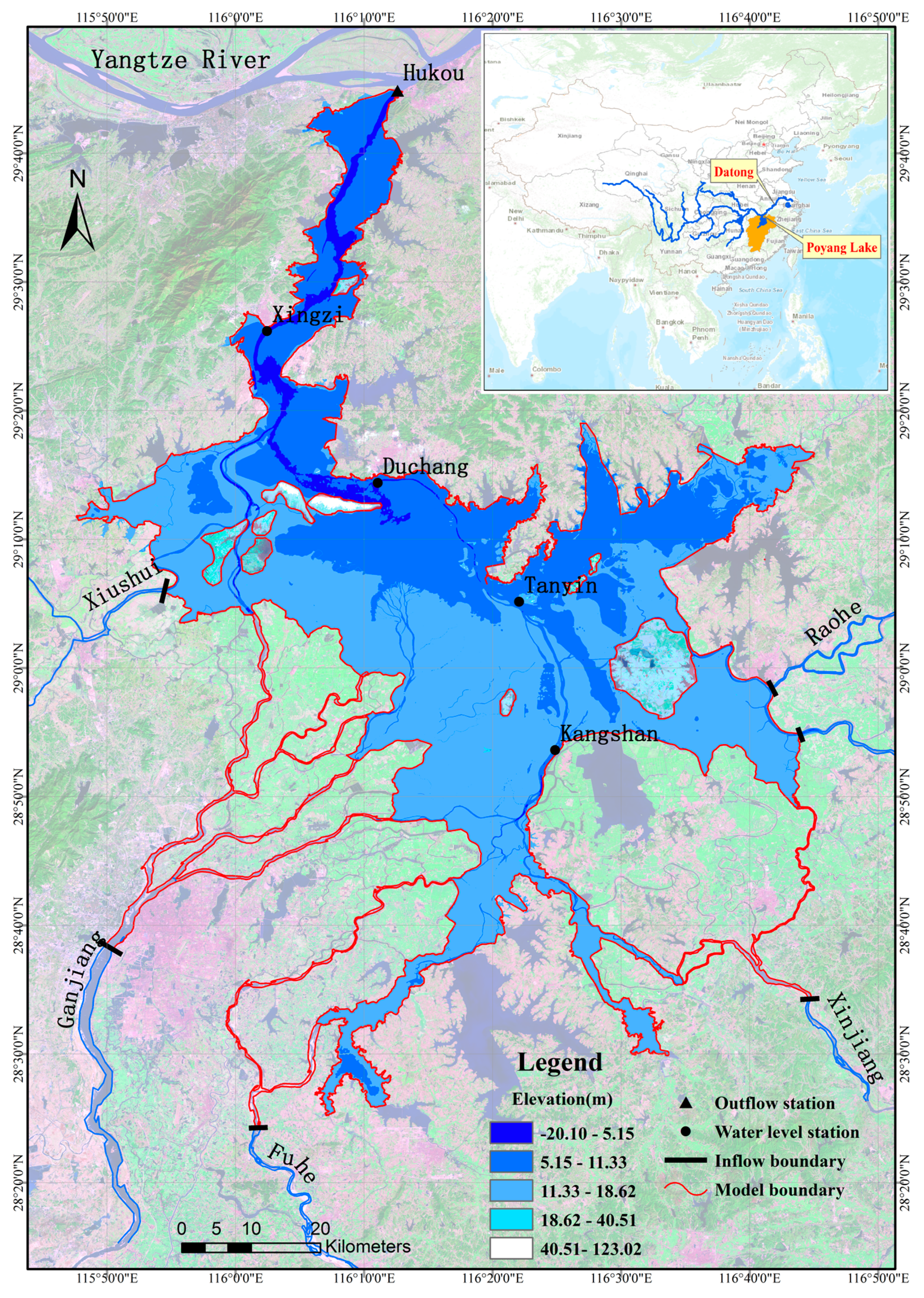
2.1. Study Area
2.2. Model Description
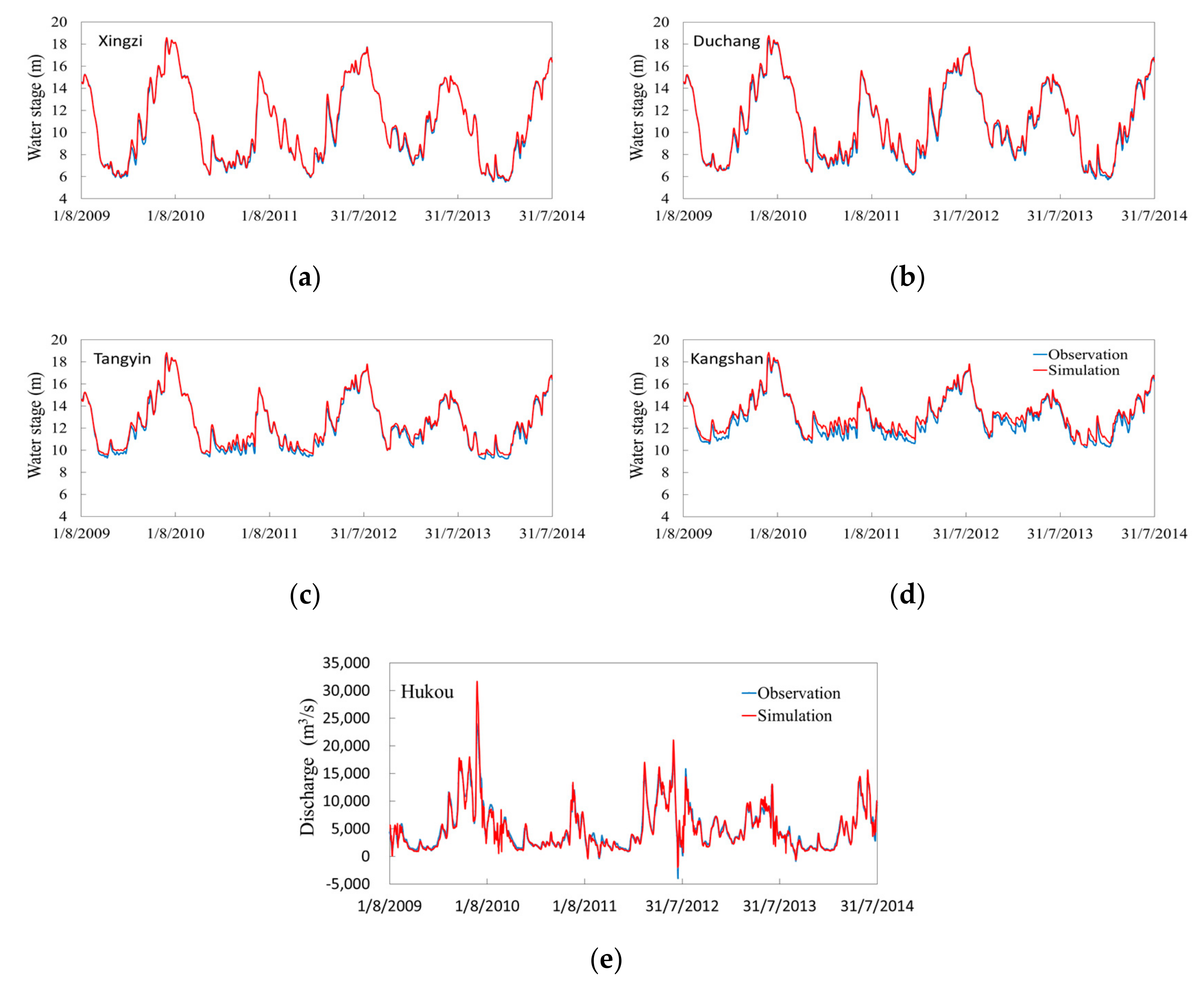
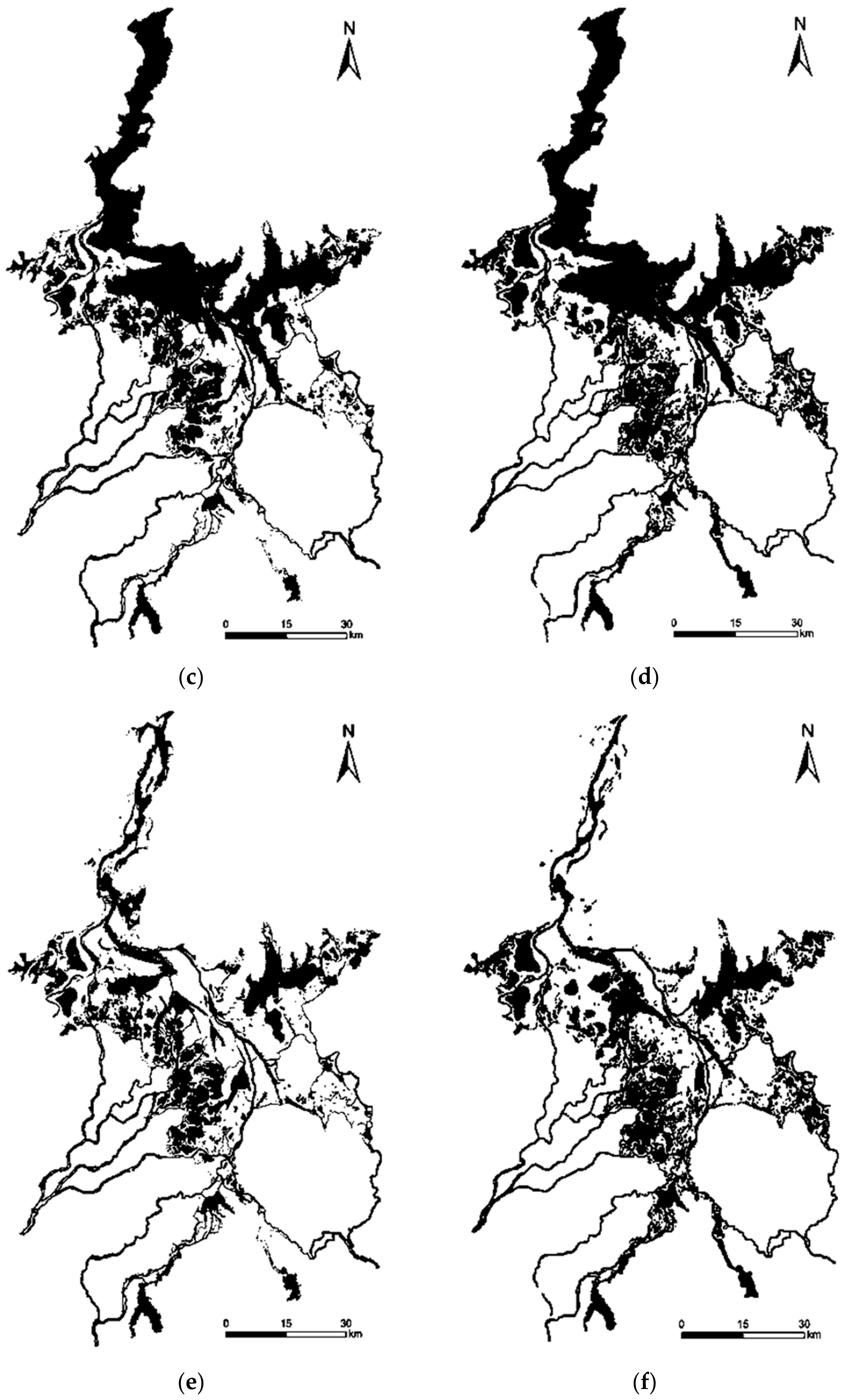
2.3. Model Calibration and Validation
2.4. Recognition of Influencing Factors
2.5. Setting of Computational Scenarios
3. Results
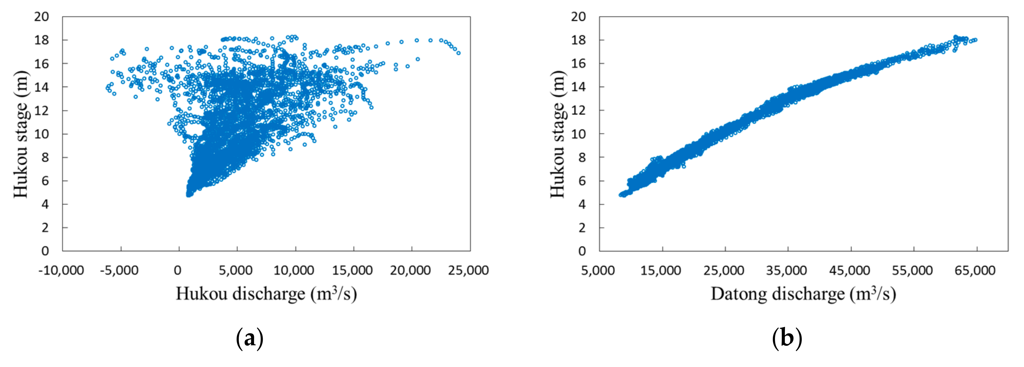
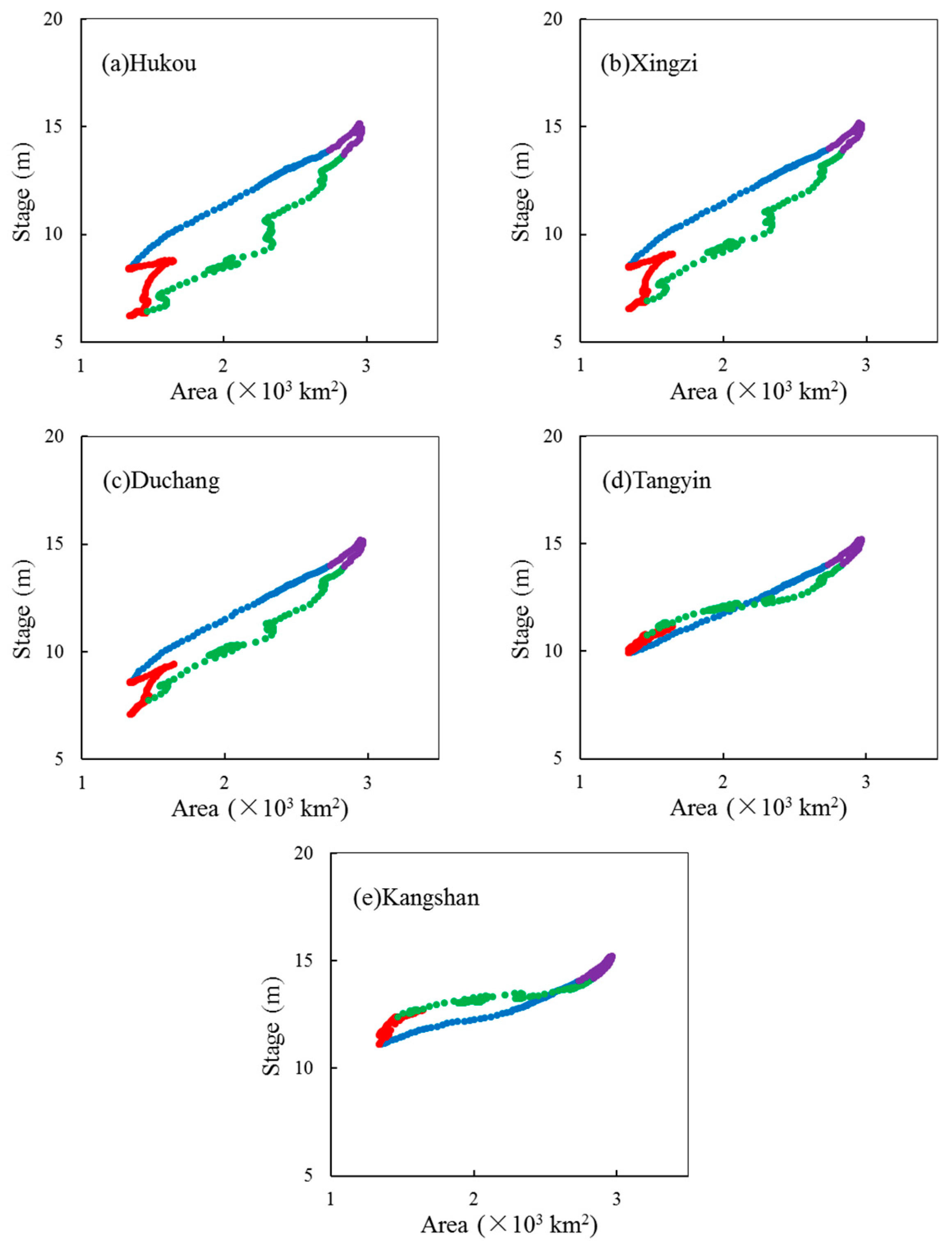
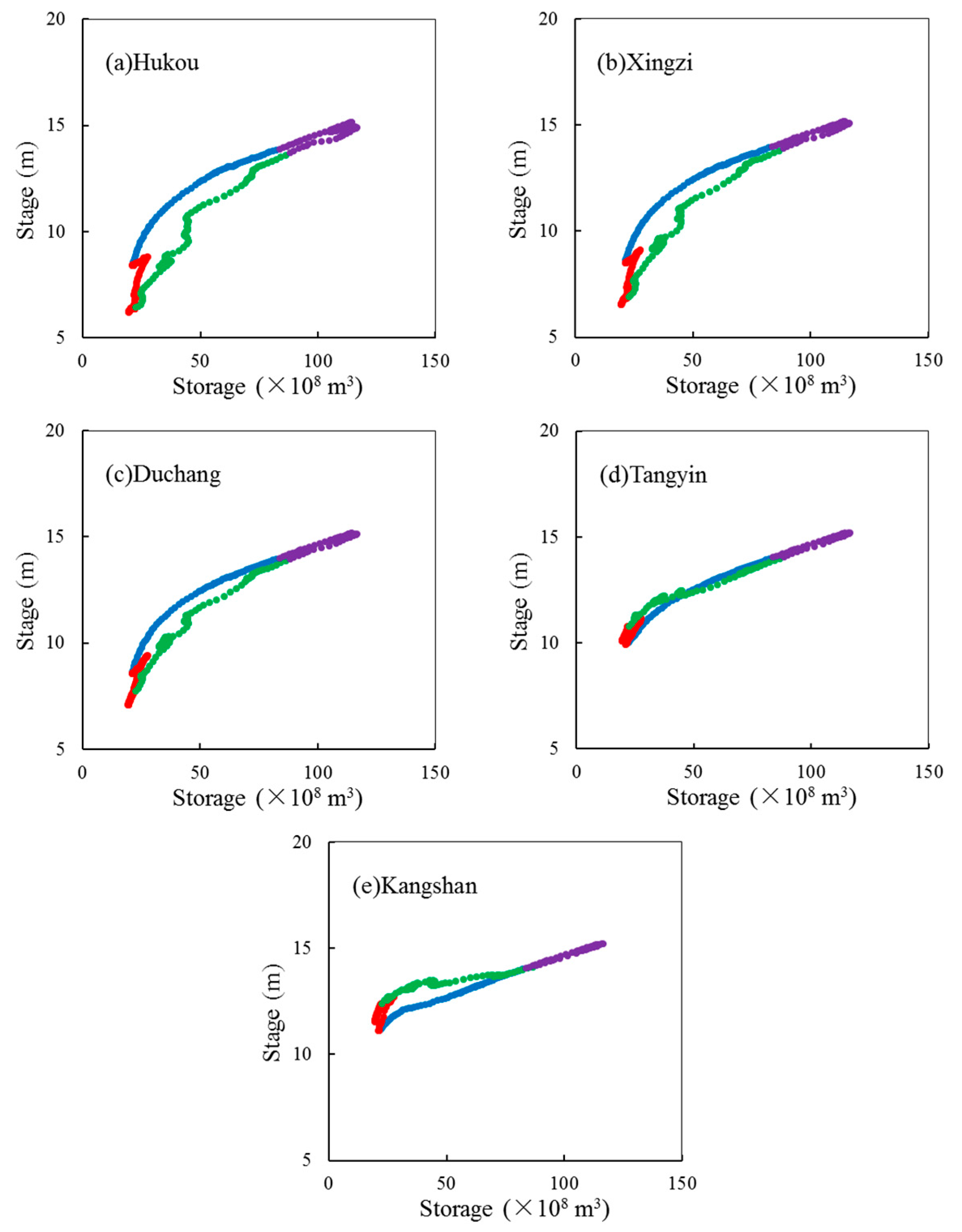
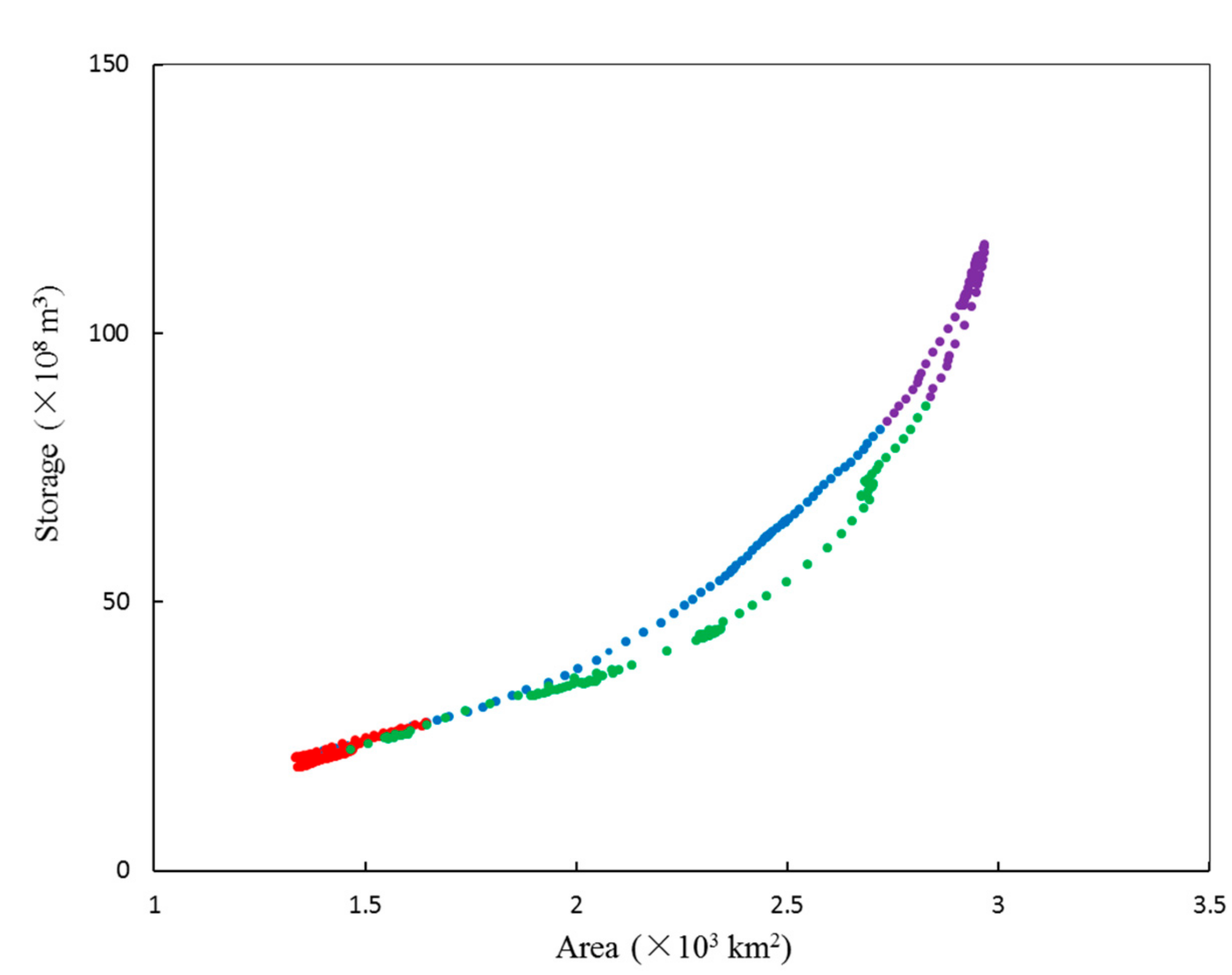
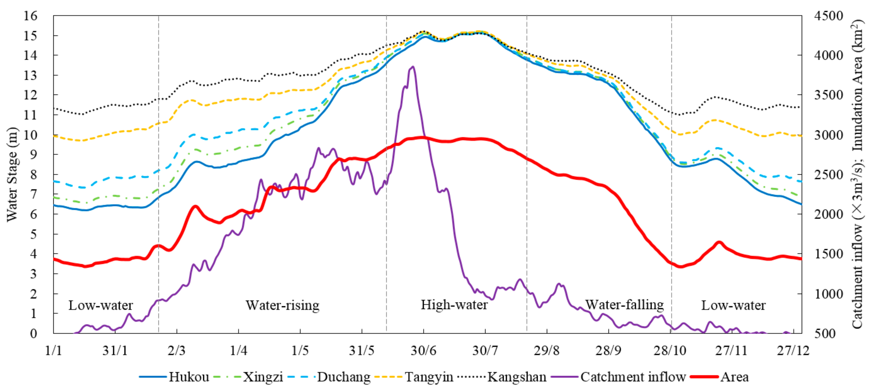
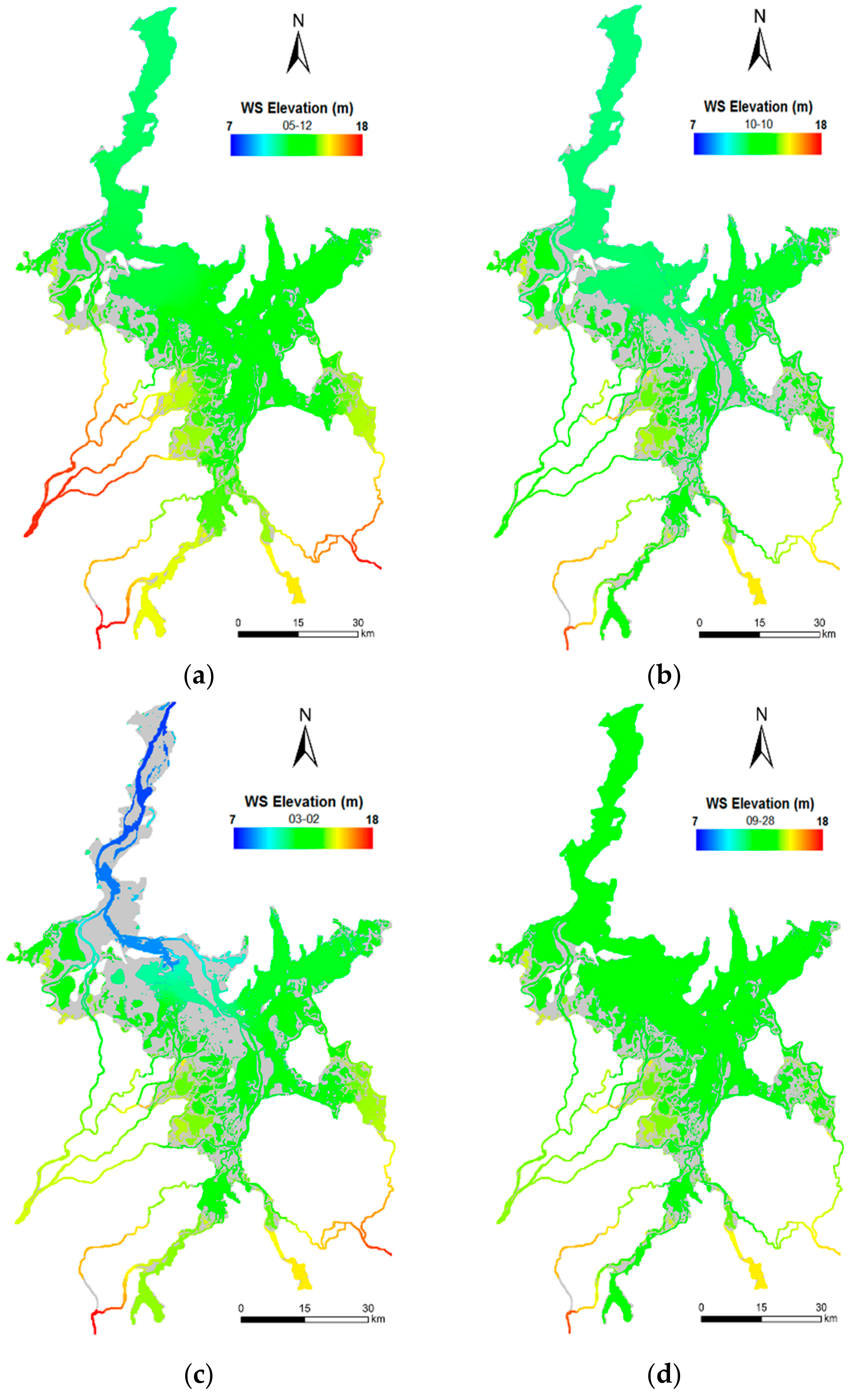
3.1. Characteristics of Hysteretic Relationships
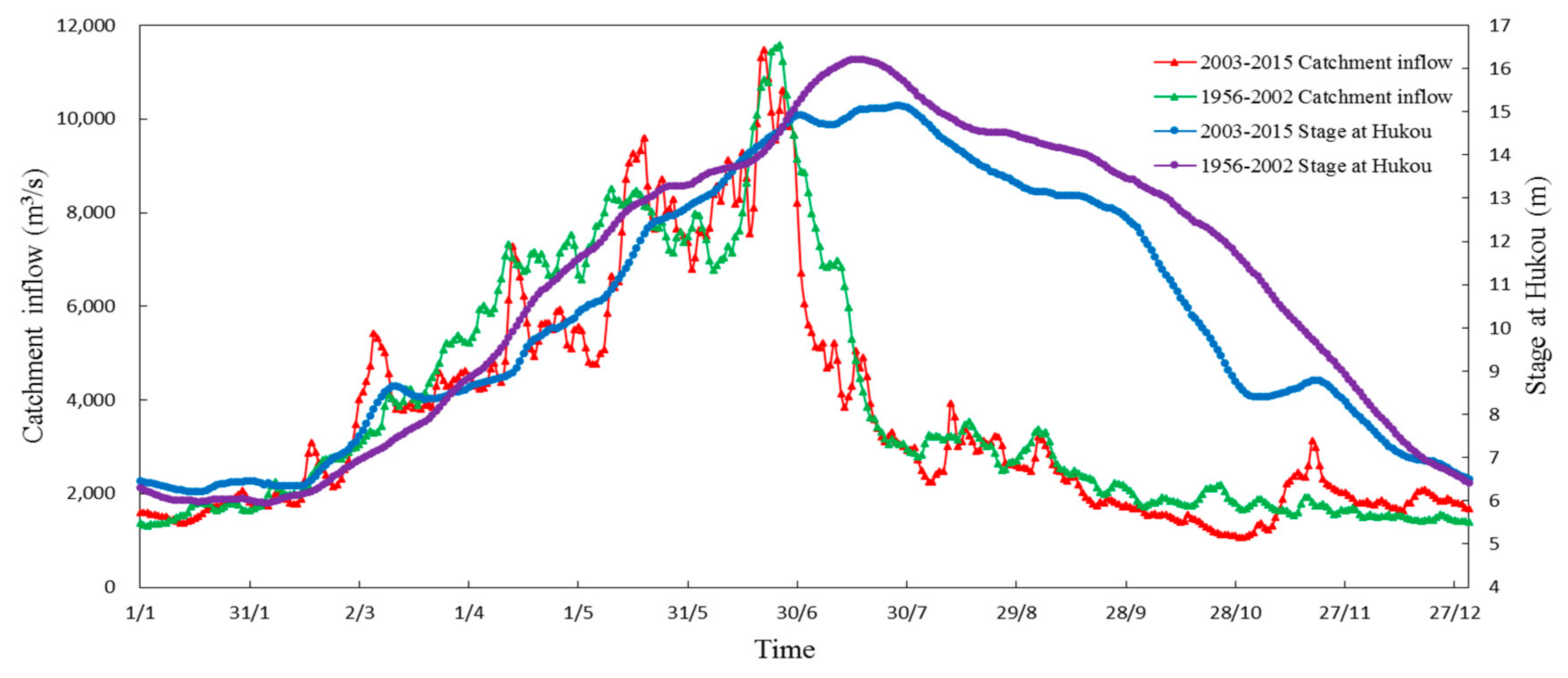
3.2. Impacts of Catchment Inflows and Yangtze River Flows
4. Discussion
5. Conclusions
Acknowledgments
Author Contributions
Conflicts of Interest
References
- Zhang, L.X.; Sergio, U.; Yang, Z.F. Emergy evaluation and economic analysis of three wetland fish farming systems in Nansi Lake area, China. J. Environ. Manag. 2011, 92, 683–694. [Google Scholar] [CrossRef] [PubMed]
- Arnesen, A.S.; Silva, T.F.; Hess, L.L.; Novo, E.M.; Rudorff, C.M.; Chapman, B.D.; McDonald, K.C. Monitoring flood extent in the lower Amazon River floodplain using ALOS/PALSAR ScanSAR images. Remote Sens. Environ. 2013, 130, 51–61. [Google Scholar] [CrossRef]
- Ogilvie, A.; Belaud, G.; Delenne, C.; Bailly, J.S.; Bader, J.C.; Oleksiak, A.; Ferry, L.; Martin, D. Decadal monitoring of the Niger Inner Delta flood dynamics using MODIS optical data. J. Hydrol. 2015, 523, 368–383. [Google Scholar] [CrossRef]
- Carroll, M.L.; Townshend, J.G.; Dimiceli, C.M.; Loboda, T.; Sohlberg, R.A. Shrinking lakes of the Arctic: Spatial relationships and trajectory of change. Geophys. Res. Lett. 2011, 38, 4–16. [Google Scholar] [CrossRef]
- Tian, H.F.; Li, W.; Wu, M.Q.; Huang, N.; Li, G.; Li, X.; Niu, Z. Dynamic Monitoring of the Largest Freshwater Lake in China Using a New Water Index Derived from High Spatiotemporal Resolution Sentinel-1A Data. Remote Sens. 2017, 9, 521. [Google Scholar] [CrossRef]
- Bryant, M.D. Global climate change and potential effects on Pacific salmonids in freshwater ecosystems of southeast Alaska. Clim. Chang. 2009, 95, 169–193. [Google Scholar] [CrossRef]
- Stevenson, J.; Siringan, F.; Finn, J.; Madulid, D.; Heijnis, H. Paoay Lake, northern Luzon, the Philippines: A record of Holocene environmental change. Glob. Chang. Biol. 2010, 16, 1672–1688. [Google Scholar] [CrossRef]
- Ma, R.; Duan, H.T.; Hu, C.M.; Yang, G.S. A half-century of changes in China’s lakes: Global warming or human influence? Geophys. Res. Lett. 2010, 37. [Google Scholar] [CrossRef]
- Tao, S.L.; Fang, J.Y.; Zhao, X.; Guo, Q.H. Rapid loss of lakes on the Mongolian Plateau. Proc. Natl. Acad. Sci. USA 2015, 112, 2281–2286. [Google Scholar] [CrossRef] [PubMed]
- Li, M.; Zhang, Q.; Li, Y.; Tan, Z. Inter-annual variations of Poyang Lake area during dry seasons: Characteristics and implications. Hydrol. Res. 2016, 47, 40–50. [Google Scholar] [CrossRef]
- Rudorff, C.M.; Melack, J.M.; Bates, P.D. Flooding dynamics on the lower Amazon floodplain: 1. Hydraulic controls on water elevation, inundation extent, and river-floodplain discharge. Water Resour. Res. 2014, 50, 619–634. [Google Scholar] [CrossRef]
- O’Kane, J.P. Hysteresis in hydrology. Acta Geophys. 2005, 53, 373–383. [Google Scholar]
- Phillips, R.W.; Spence, C.; Pomeroy, J.W. Connectivity and runoff dynamics in heterogeneous basins. Hydrol. Process. 2011, 25, 3061–3075. [Google Scholar] [CrossRef]
- Wolfs, V.; Willems, P. Development of discharge-stage curves affected by hysteresis using time varying models, model trees and neural networks. Environ. Model. Softw. 2014, 55, 107–119. [Google Scholar] [CrossRef]
- Sproles, E.A.; Leibowitz, S.G.; Reager, J.T.; Wigington, P.J.; Famiglietti, J.S. GRACE storage-runoff hystereses reveal the dynamics of regional watersheds. Hydrol. Earth Syst. Sci. 2015, 19, 3253–3272. [Google Scholar] [CrossRef]
- Boyer, M.C. Streamflow measurement. In Handbook of Applied Hydrology; Chow, V.T., Ed.; McGraw-Hill: New York, NY, USA, 1964; Chapter 15. [Google Scholar]
- Shankman, D.; Keim, B.D.; Song, J. Flood frequency in China’s Poyang Lake region: Trends and teleconnections. Int. J. Climatol. 2006, 26, 1255–1266. [Google Scholar] [CrossRef]
- Feng, L.; Hu, C.; Chen, X.; Zhao, X. Dramatic inundation changes of China’s two largest freshwater lakes linked to the Three Gorges Dam. Environ. Sci. Technol. 2013, 47, 9628–9634. [Google Scholar] [CrossRef] [PubMed]
- Zhao, X. Monitoring the dynamics of wetland inundation by random sets on multi-temporal images. Remote Sens. Environ. 2011, 115, 2390–2401. [Google Scholar] [CrossRef]
- Han, X.; Chen, X.; Feng, L. Four decades of winter wetland changes in Poyang Lake based on Landsat observations between 1973 and 2013. Remote Sens. Environ. 2015, 156, 426–437. [Google Scholar] [CrossRef]
- Huang, C.; Chen, Y.; Zhang, S.Q.; Liu, R. Surface Water Mapping from Suomi NPP-VIIRS Imagery at 30 m Resolution via Blending with Landsat Data. Remote Sens. 2016, 8, 631. [Google Scholar] [CrossRef]
- Chen, L.; Jin, Z.Y.; Michishita, R.; Xu, B. Dynamic monitoring of wetland cover changes using time-series remote sensing imagery. Ecol. Inform. 2014, 24, 17–26. [Google Scholar] [CrossRef]
- Feng, L.; Hu, C.; Chen, X.; Cai, X.; Tian, L. Assessment of inundation changes of Poyang Lake using MODIS observations between 2000 and 2010. Remote Sens. Environ. 2012, 121, 80–92. [Google Scholar] [CrossRef]
- Mei, X.; Dai, Z.; Fagherazzi, S.; Chen, J. Dramatic variations in emergent wetland area in China’s largest freshwater lake, Poyang Lake. Adv. Water Resour. 2016, 96, 1–10. [Google Scholar] [CrossRef]
- Zhang, Q.; Werner, A.D. Hysteretic relationships in inundation dynamics for a large lake-floodplain system. J. Hydrol. 2015, 527, 160–171. [Google Scholar] [CrossRef]
- Guo, H.; Hu, Q.; Zhang, Q.; Feng, S. Effects of the Three Gorges Dam on Yangtze River flow and river interaction with Poyang Lake, China: 2003–2008. J. Hydrol. 2012, 416, 19–27. [Google Scholar] [CrossRef]
- Sun, S.L.; Chen, H.S.; Ju, W.M.; Song, J.; Li, J.J.; Ren, Y.J.; Sun, J. The past and future changes of streamflow in Poyang Lake Basin, Southeastern China. Hydrol. Earth Syst. Sci. 2012, 16, 2005–2020. [Google Scholar] [CrossRef]
- Leauthaud, C.; Belaud, G.; Duvail, S.; Moussa, R.; Olivier, G.; Albergel, J. Characterizing floods in the poorly gauged wetlands of the Tana River Delta, Kenya, using a water balance model and satellite data. Hydrol. Earth Syst. Sci. 2013, 17, 3059–3075. [Google Scholar] [CrossRef]
- Aires, F.; Papa, F.; Prigent, C.; Cretaux, J.F.; Nguyen, M.B. Characterization and Space–Time Downscaling of the Inundation Extent over the Inner Niger Delta Using GIEMS and MODIS Data. J. Hydrometeorol. 2014, 15, 171–192. [Google Scholar] [CrossRef]
- Wang, P.; Lai, G.; Li, L. Predicting the Hydrological Impacts of the Poyang Lake Project Using an EFDC Model. J. Hydrol. Eng. 2015, 20, 05015009. [Google Scholar] [CrossRef]
- Lai, X.; Huang, Q.; Zhang, Y.; Jiang, J. Impact of lake inflow and the Yangtze River flow alterations on water levels in Poyang Lake, China. Lake Reserv. Manag. 2014, 30, 321–330. [Google Scholar] [CrossRef]
- Gao, J.H.; Jia, J.; Kettner, A.J.; Xing, F.; Wang, Y.P.; Xu, X.N.; Yang, Y.; Zhou, X.Q. Changes in water and sediment exchange between the Changjiang River and Poyang Lake under natural and anthropogenic conditions, China. Sci. Total Environ. 2014, 481, 542–553. [Google Scholar] [CrossRef] [PubMed]
- Hu, Q.; Feng, S.; Guo, H.; Chen, G.; Jiang, T. Interactions of the Yangtze River flow and hydrologic processes of the Poyang Lake, China. J. Hydrol. 2007, 347, 90–100. [Google Scholar] [CrossRef]
- Wu, N.H.; You, L.; Liu, T.H.; Huang, Z.W. Experimental study on the effect of the Three Gorges Project on water level in Lake Poyang. J. Lake Sci. 2014, 26, 522–528. (In Chinese) [Google Scholar]
- Qi, H.; Lu, J.; Sauvage, S.; Sanchez, J.M. Water age prediction and its potential impacts on water quality using a hydrodynamic model for Poyang Lake, China. Environ. Sci. Pollut. Res. 2016, 23, 13327–13341. [Google Scholar] [CrossRef] [PubMed]
- Hamrick, J.M. A Three-Dimensional Environmental Fluid Dynamics Computer Code: Theoretical and Computational Aspect; Virginia Institute of Marine Science, College of William and Mary: Gloucester Point, VA, USA, 1992. [Google Scholar]
- Li, L.; Lai, G.Y.; Wang, P. Study on the dynamic correlation between water-level and reservoir capacity of Poyang Lake based on EFDC. J. Appl. Sci. Eng. 2016, 19, 413–428. [Google Scholar]
- Feng, L.; Hu, C.M.; Chen, X.L.; Li, R.F.; Tian, L.Q.; Murch, B. MODIS observations of the bottom topography and its inter-annual variability of Poyang Lake. Remote Sens. Environ. 2011, 115, 2729–2741. [Google Scholar] [CrossRef]
- Mishra, S.K.; Seth, S.M. Use of hysteresis for defining the nature of flood wave propagation in natural channels. Hydrol. Sci. J. 1996, 41, 153–170. [Google Scholar] [CrossRef]
- Xiong, J.; Lai, G.; Peng, X.; Sheng, Y. Poyang Lake area estimation based on EFDC model. J. Nanjing Univ. Inf. Sci. Technol. 2016, 8, 56–63. (In Chinese) [Google Scholar]


| Station | Mean Absolute Error | Mean Relative Error | Root-Mean-Square Error | Nash–Sutcliffe Model Efficiency Coefficient |
|---|---|---|---|---|
| Water stage validation | ||||
| Xingzi | 0.138 | 1.310 | 0.205 | 0.996 |
| Duchang | 0.242 | 2.267 | 0.305 | 0.990 |
| Tangyin | 0.230 | 1.917 | 0.292 | 0.981 |
| Kangshan | 0.365 | 2.851 | 0.434 | 0.931 |
| Discharge validation | ||||
| Hukou | 518.079 | 10.867 | 746.029 | 0.933 |
| Time | Water Level at Xingzi (m) | Area Derived from Remote Sensing Images (km2) | Area Derived from the Simulated Model (km2) | Absolute Error (km2) | Relative Error (%) |
|---|---|---|---|---|---|
| 20 July 2014 | 16.473 | 3065.349 | 3016.505 | −48.844 | −1.593 |
| 5 October 2013 | 11.562 | 1769.924 | 1865.009 | 95.086 | 5.372 |
| 22 November 2013 | 7.094 | 1158.844 | 1288.094 | 129.249 | 11.153 |
| Item | S1 | S2 | S3 | S4 | S5 | S6 | S7 |
|---|---|---|---|---|---|---|---|
| Catchment inflow | Daily mean for 2003 to 2015 | Average of S1 | Increase by 20% of S1 | Decrease by 20% of S1 | Same as S1 | Same as S1 | Same as S1 |
| Hukou stage | Daily mean for 2003 to 2015 | Same as S1 | Same as S1 | Same as S1 | Average of S1 | Increase by 20% of S1 | Decrease by 20% of S1 |
| Item | Hukou | Xingzi | Duchang | Tangyin | Kangshan |
|---|---|---|---|---|---|
| Area and stage | 0.230 | 0.195 | 0.162 | 0.089 | 0.118 |
| Storage and stage | 0.126 | 0.102 | 0.084 | 0.048 | 0.075 |
| Item | Catchment Inflow | Hukou Stage | ||||
|---|---|---|---|---|---|---|
| S2 | S3 | S4 | S5 | S6 | S7 | |
| Hukou | −89% | 16% | −19% | - | −57% | 73% |
| Xingzi | −94% | 12% | −13% | −48% | −52% | 48% |
| Duchang | −97% | 8% | −12% | −37% | −47% | 33% |
| Tangyin | −84% | 1% | −1% | −38% | −52% | 5% |
| Kangshan | −82% | 34% | −10% | −59% | −33% | 47% |
| Average | −89% | 14% | −11% | −46% | −48% | 41% |
| Period | Hukou | Xingzi | Duchang | Tangyin | Kangshan |
|---|---|---|---|---|---|
| Water-rising | 1.00 | 0.97 | 0.83 | 0.55 | 0.41 |
| Water-falling | 1.00 | 1.00 | 0.98 | 0.76 | 0.59 |
© 2017 by the authors. Licensee MDPI, Basel, Switzerland. This article is an open access article distributed under the terms and conditions of the Creative Commons Attribution (CC BY) license (http://creativecommons.org/licenses/by/4.0/).
Share and Cite
Huang, A.; Peng, W.; Liu, X.; Du, Y.; Zhang, S.; Wang, S.; Du, F.; Dong, F. Characteristics and Factors Influencing the Hysteresis of Water Area–Stage Curves for Poyang Lake. Water 2017, 9, 938. https://doi.org/10.3390/w9120938
Huang A, Peng W, Liu X, Du Y, Zhang S, Wang S, Du F, Dong F. Characteristics and Factors Influencing the Hysteresis of Water Area–Stage Curves for Poyang Lake. Water. 2017; 9(12):938. https://doi.org/10.3390/w9120938
Chicago/Turabian StyleHuang, Aiping, Wenqi Peng, Xiaobo Liu, Yanliang Du, Shijie Zhang, Shiyan Wang, Fei Du, and Fei Dong. 2017. "Characteristics and Factors Influencing the Hysteresis of Water Area–Stage Curves for Poyang Lake" Water 9, no. 12: 938. https://doi.org/10.3390/w9120938
APA StyleHuang, A., Peng, W., Liu, X., Du, Y., Zhang, S., Wang, S., Du, F., & Dong, F. (2017). Characteristics and Factors Influencing the Hysteresis of Water Area–Stage Curves for Poyang Lake. Water, 9(12), 938. https://doi.org/10.3390/w9120938