Article

Spatial and Temporal Variation in Local Stormwater Infrastructure Use and Stormwater Management Paradigms over the 20th Century

Department of Biological Sciences, Idaho State University, 921 South 8th Avenue, Stop 8007, Pocatello, ID 83209-8007, USA
Water 2016, 8(7), 310; https://doi.org/10.3390/w8070310
Submission received: 17 June 2016 / Revised: 11 July 2016 / Accepted: 14 July 2016 / Published: 22 July 2016
(This article belongs to the Special Issue Urban Drainage and Urban Stormwater Management)

Abstract

:
Stormwater management has significant consequences for urban hydrology, water quality, and flood risk, and has changed substantially over history, but it is unknown how these paradigm shifts play out at the local scale and whether local changes in stormwater infrastructure use follow similar trajectories across cities. This research addressed: (1) How does current infrastructure use and past infrastructure transitions vary across three cities with similar biophysical and climatic contexts but different development histories? and (2) How did stormwater and flood management paradigms change from early urbanization to current day in a single city? The use of storm sewers, detention basins, and canals for stormwater management was quantified for three cities in Utah, USA, over the 20th century. Stormwater management paradigms were quantified using media content analysis of newspaper articles from historic and recent periods in Salt Lake City. Results suggest that stormwater infrastructure development is decoupled from imperviousness across cities, and that newer and smaller cities follow different trajectories of stormwater management over time. This research highlights that there is no single model of urban hydrology and that heterogeneity in urban water management over time and space reflects shifting priorities and social learning.

1. Introduction

Urbanization has tremendous consequences for hydrological processes through the alteration of land cover [1], burial of streams [2], creation and destruction of lakes [3], re-plumbing of watersheds with stormwater infrastructure [4,5], and restoration and redesign of streams [6]. Depending on design, stormwater infrastructure can exacerbate or mitigate the effects of urbanization on the transport of water, nutrients, and other pollutants from urban watersheds [5,6,7,8,9,10]. Social consequences of stormwater infrastructure design include risk of exposure to flooding and water pollution [11], as well as benefits derived from multiuse infrastructure [12]. Information on stormwater infrastructure is important for understanding variation in the effects of urbanization on hydrological patterns across cities [13]. Therefore, knowledge about the locations, designs, and timing of stormwater infrastructure use is necessary to understand variation in the current and past patterns of urban hydrology, water quality, and flood risk across cities, as well as the consequences of climate change for those outcomes [11,14,15].
How urban hydrologic landscapes are designed and the objectives they are meant to address have changed over time at large [16,17,18] and local scales [4,5,19]. Much of the urban stream and urban hydrology literature assumes that all urban systems follow the same trajectory of change from no infrastructure, to centralized storm sewer systems, to decentralized systems and the use of green infrastructure [12,17,18,20,21], leading to relatively homogenous current conditions across cities [3,22]. A further assumption in this literature is that approaches and lessons about sustainable stormwater management are transferable across cities [21]. Yet we know from studies of other urban processes such as land cover change and urban metabolism that trajectories of urban structure and function can vary substantially across cities [23,24], and a recent review by Parr et al. [25] details why stormwater (and other water) infrastructure is likely to vary across cities based on current and historical paradigms and the stage, trajectory, intensity, and configuration of urban development. This suggests that spatial and temporal variation in urban stormwater infrastructure is likely more complex than current conceptual models suggest. Much of the previous research has focused on large, older cities that are more likely to have followed similar trajectories and to be subject to similar regulations and patterns of growth [20,22,26], but there is reason to believe that patterns may differ in smaller and new cities. As of the 2010 Census, 86% of urban clusters had populations of less than 50,000 and those represented 12% of the urban population and 18% of the urban land area in the United States. Small and mid-sized cities together, those with populations under 200,000 accounted for 95% of urban clusters, 24% of the urban population, and 35% of urban land area [27]. Thus small and mid-sized cities represent a significant contingent of urban systems in the United States. Incorporating information on stormwater management from small and mid-sized cities, which includes younger cities, is an important next step in developing a more complete understanding of cities beyond what we have learned from older and larger urban systems.
This research addresses two key unknowns about current and past stormwater and flood management. The first is to what degree cities follow the same trajectories. This is especially important to understand for newer and smaller cities. Can we apply the same models that we use to understand urban hydrology in older and larger cities, or are new models required? The second unknown is whether large scale paradigm shifts are relevant at the local scale. Much of the previous research assumes that local scale patterns will mirror national-level trends, but it is unknown to what extent local management goals are responsive to local conditions as well. This becomes particularly important for the consideration of future trajectories of change. I address two specific research questions:
(1)
How does current infrastructure use and past infrastructure transitions vary across 3 cities with similar biophysical and climatic contexts but different development stages and histories?
(2)
How did stormwater and flood management paradigms change from early urbanization to current day in a single city?

2. Materials and Methods
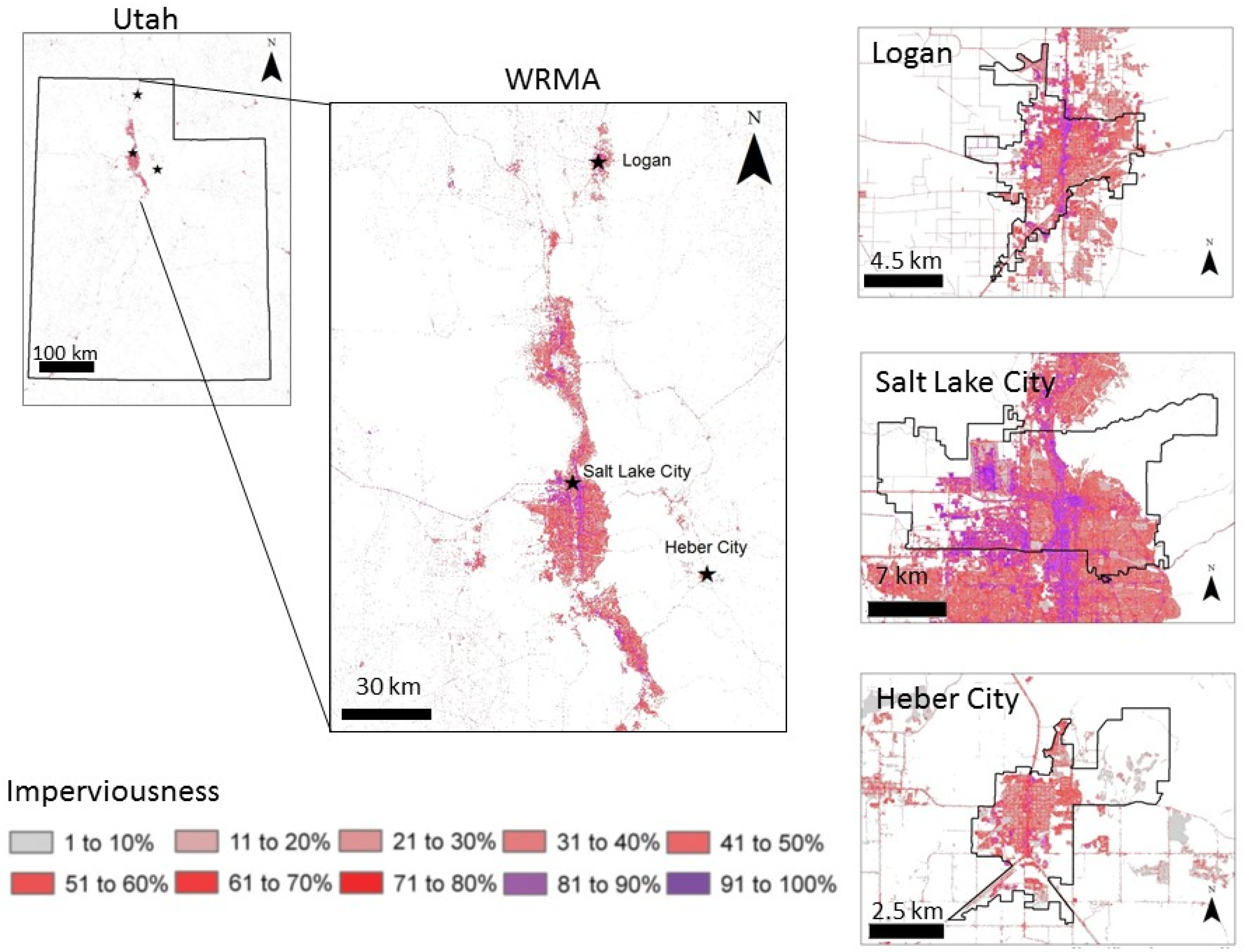
2.1. Study Sites

To address the first question, I focused on three small and mid-sized cities along the urbanizing Wasatch Range in northern Utah, Salt Lake City, Logan, and Heber City, UT (Figure 1). Question 2 addressed only Salt Lake City. As of 2010, the Wasatch Range Metropolitan Area (WRMA) had a population of approximately 2.4 million people, making it home to 86% of Utah’s population. The region is rapidly growing, and population is expected to double by 2060 [28]. The climate across the WRMA is semi-arid. Precipitation falls predominantly as snow during cold winters, while summers are hot and dry. All three study cities are located at mountain fronts. Rivers and streams carry snowmelt from adjacent mountains through urban areas, which can cause substantial flooding problems during spring snowmelt season. All three study cities have strong agricultural legacies. A key component of these legacies is the use of irrigation canals to move water across the landscape. These canals continue to be used to deliver irrigation water, as well as to drain groundwater and floodwaters from urban areas [29].
The three study cities have similar biophysical contexts and agricultural legacies, but they have each followed different growth trajectories. Salt Lake City is the largest and oldest city in Utah, though it is still mid-sized, was settled in 1847, underwent the most rapid population growth from 1880 to 1890 (11.5% annually) and 1900–1910 (7% annually), and has a current population of 191,180 (Table 1). Logan, UT is a small city with a population of 48,913. Population growth in Logan accelerated in the 1950s and population increased by 2%–3% annually from 1970 to 2000. Heber City is the smallest of the three cities, with a current population of 12,911. Population growth in Heber has only occurred recently, but since 1990, population has been increasing 5%–6% annually. Note that political, rather than morphological, boundaries were chosen for this study since decisions about stormwater infrastructure are made at the municipal level. While land use data are not available for the three study cities, it is likely that Salt Lake City, as an older city and as an urban hub for the region, has a larger proportion of commercial and industrial land area than the other two study cities.

2.2. Reconstructing Infrastructure Use

The current and historical use of infrastructure in each of the study cities was reconstructed using historic public records and satellite imagery. Shapefiles of stormwater infrastructure were obtained for Salt Lake City from the Salt Lake County Flood Control District, for Logan from Logan City Public Utilities, and for Heber from the City Engineering department. Data on the locations of retention and detention basins was available for Logan and Heber but not for Salt Lake City. The locations of basins in Salt Lake City were identified manually using LiDAR data and aerial imagery, following the methods of Hale et al. [5]. The current density of each type of stormwater infrastructure for each city was calculated as the total length (for storm sewers and channels) or the total area (for retention and detention basins) of infrastructure divided by the total area of built parcels for the city. Parcel data for each city, including the date of parcel construction were obtained from the county assessor’s offices in Salt Lake, Wasatch, and Cache Counties. Information on infrastructure construction dates was not readily available, so dates of infrastructure construction were estimated using parcel data. Stormwater infrastructure was assigned the age of the nearest parcel [5].
To compare trajectories of infrastructure use with changes in imperviousness, parcel and impervious land cover data were used to reconstruct imperviousness over the study period. The impervious surface cover dataset for 2011 from the National Land Cover Database [30,31] was used to calculate imperviousness for each parcel in each of the three cities. Assuming that imperviousness for each parcel has not changed since the parcel was originally built up, the construction dates associated with each parcel were used to calculate the average % impervious surface cover (as a percent of the area of built parcels as of 2010) for each city and each year from 1900 to 2010.

2.3. Defining Management Paradigms: Media Content Analysis

Stormwater and flood control management paradigms were assessed using content analysis of historic and current media. Media content analysis is a useful tool for understanding how environmental problems and solutions are framed [32]. The media provides a higher temporal resolution data source than management documents, such as stormwater master plans, which are updated infrequently, and additionally provides more detail on public discourse surrounding management decisions, including perspectives from business owners and urban residents. Management paradigms were defined as conceptual models of stormwater management, including: what disturbances or problems management aims to address, what the causes of those problems are, what the solutions are to those problems, what external and local constraints or drivers hinder or accelerate changes.
Historic newspaper articles were obtained from the Utah Digital Newspaper Archive [33] by searching for “flood” “stormwater” “storm water”. Because of the small number of articles available for early years and the uneven availability of different newspapers, articles were collected from three different local Salt Lake City newspapers: Deseret News, Salt Lake Telegram, and Salt Lake Tribune. More recent newspaper articles, for 2004 to 2013 were obtained by searching the ProQuest Newsstand database using the search terms “flood”, “stormwater”, and “storm water”. Articles were then read to determine relevance. Overall, 50 articles were coded for the historic period of 1900 to 1940, and 46 articles were coded for the recent period of 2004 to 2013 (see paragraph below on codebook). The historic period was a significant period of growth for Salt Lake City: imperviousness increased from nearly 0% to 10%, the population tripled to nearly 150,000 and the area of developed parcels increased to over 1300 ha. Although population growth was much lower in the recent period (population increased by 5000 from 2000 to 2010), the additions of impervious area and developed parcels were similar to those during the historic period (7% increase in imperviousness and 750 new ha of developed parcels). Fewer news articles on flooding and stormwater were published during the early period, an average of 1.2 articles per year, compared to 5.1 articles per year during the recent time period. Despite a larger volume of media on flooding and stormwater in the second period, only one specific flood event was reported, compared to 19 unique flood events in the early period. Thus, while there were fewer flooding events in the second period, there was substantially more media coverage of flooding and stormwater issues.
The codebook for the content analysis was developed iteratively through reading a subset of the sample articles. Suites of statements were developed for each the following aspects of management paradigms: problems caused by flooding or stormwater, causes of flooding or stormwater problems, solutions to address flooding or stormwater problems, and constraints or top-down factors that limit or require implementation of solutions. For each statement in the codebook, an article was coded 0 if there was nothing mentioned related to the code, 1 if the statement was found in the article. For analysis, counts of the coded results for each statement were summed by year, decade, or period depending on the analysis and divided by the total number of articles for that period to obtain the proportion of articles that mentioned each statement for each period. This normalized the frequency of statements by the frequency of articles for each time period and allowed comparisons across periods. Note that, because each article could have multiple ideas and coded statements were not mutually exclusive, proportions across statements can add up to less than or greater than 1.

3. Results

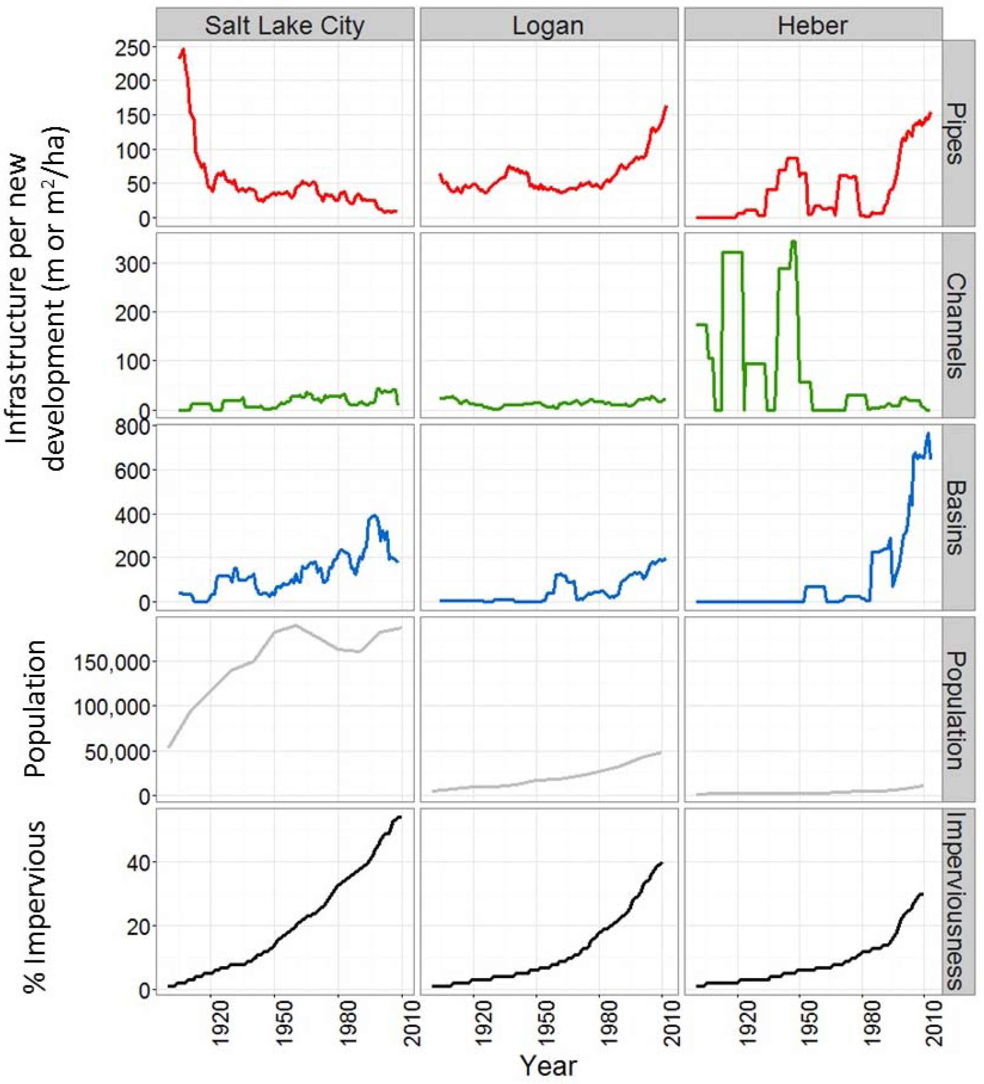
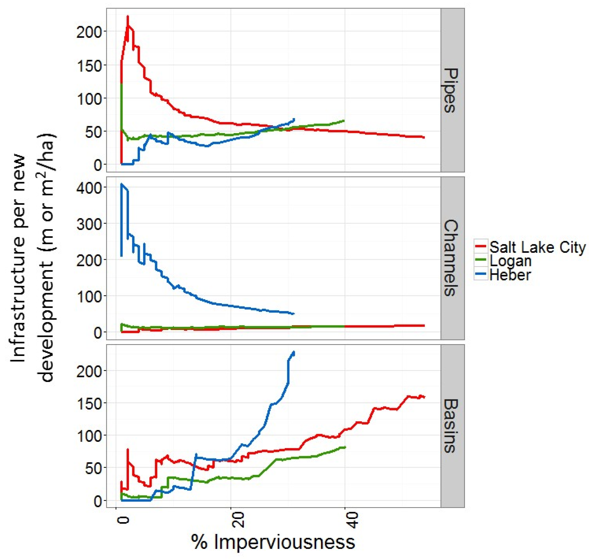
3.1. Research Question 1: Infrastructure Use across Cities

The overall patterns of infrastructure density—length or area of infrastructure normalized by impervious surface area or total area of developed parcels—were very different across the three study cities. As of 2010, pipe density was lowest in Salt Lake City (41 m/ha built parcels), highest in Heber (69 m/ha built parcels), the newest and smallest city, and intermediate in Logan (65 m/ha built parcels). Channel density was by far the highest in Heber (50 m/ha built parcels), more than double the density of channels in Logan (15 m/ha built parcels) and Salt Lake City (18 m/ha built parcels). In all three cities, these channels are irrigation canals that double as conveyance for stormwater and groundwater [29]. Heber had the highest density of basins (225 m2/ha built parcels). Salt Lake City had a lower density of retention and detention basin structures (158 m2/ha of built parcels) and the density of basin structures was lowest in Logan (81 m2/ha built parcels).
In terms of transitions in infrastructure use over time, Salt Lake City differed from Logan and Heber, the smaller study cities (Figure 2). The use of storm sewer pipes in Salt Lake City was highest in the early 1900s, when the use of other infrastructure was low. In the late 1970s, the use of retention and detention basins dramatically increased, responding to the establishment of a detention requirement for new development in 1978. The use of channels in Salt Lake City, primarily irrigation canals that double as stormwater conveyance channels, did not change substantially over the study period (Figure 2).
The use of infrastructure in Logan and Heber followed a different trajectory than Salt Lake City. In both of these cities, the use of all types of infrastructure was low at the beginning of the century relative to new development, but infrastructure use accelerated in the 1980s (Figure 2). The exception was the high use of channels in Heber from 1900 to 1950. Like the other cities, these channels are irrigation and drainage ditches that are legacies from previous agricultural land use. In Heber, the primary land use in the first half of the study period was agricultural, and these canals were likely constructed to deliver irrigation water and drain the young town from stormwater, snowmelt, and high groundwater.
At any given point in time, the three cities were using different combinations of infrastructure. However, these cities are at very different stages, and potentially paths, of development in terms of population and impervious surfaces. To address the question of whether these three cities are following similar paths relative to development (i.e., % imperviousness), it is useful to plot infrastructure density against % impervious surface cover—a proxy for urbanization (Figure 3). If the three cities are following the same trajectory, we would expect that for any given level of development (measured as the proportion of impervious cover for the city), the density of infrastructure at that point would be the same for each city. An alternative hypothesis is that cities follow different trajectories depending upon when they began urbanizing due to changes in the standards for stormwater management over time. In fact, the data show that some general patterns of these trajectories of infrastructure densities across these cities are similar, but with important variations (Figure 3). For pipe infrastructure, Salt Lake City had the highest density of pipe infrastructure at low impervious surface cover (~4% imperviousness), and the density of storm sewer pipes has been declining steadily over time as new development occurs without major increases in pipes. In contrast, pipe density in Logan and Heber has been increasing steadily as development has progressed. Rather than converging on a single density of pipes, the three cities appear to be diverging, with Heber increasing pipe density at the greatest rate, Logan increasing at a lower rate, and Salt Lake City declining (Figure 3).
Patterns of channel density over time were also highly variable across the three cities (Figure 3). Heber had by far the highest density of channels during early development, but that density has declined rapidly as new development occurs in areas with fewer legacy agricultural canals and no new canals are built. The density of canals in both Logan and Salt Lake City appear to be relatively stable over time, perhaps because there were no concentrated areas of canals or drainage ditches in these cities during early development. The use of retention and detention basins follows the most consistent pattern across the three cities (Figure 3). Basin density increased in all three cities at low levels of imperviousness and has increased steadily in all cities. The density of basins increased at similar rates in Logan and Salt Lake City but much more rapidly in Heber.

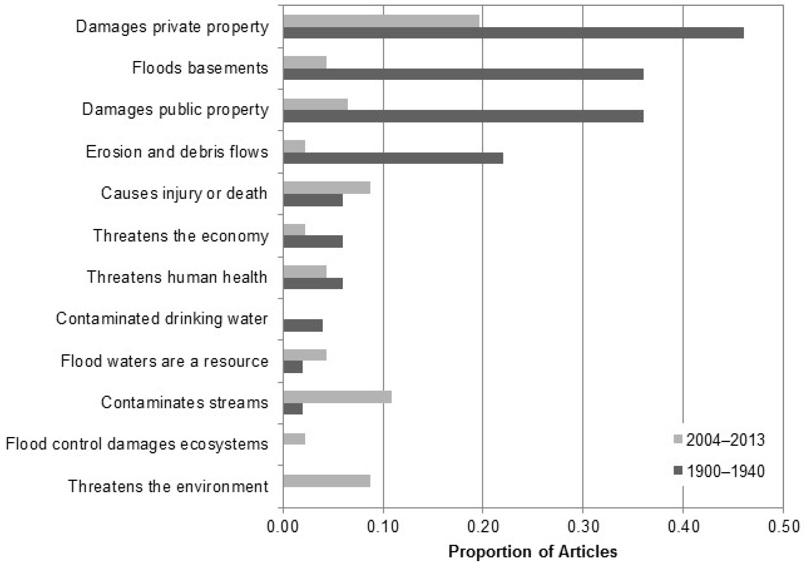
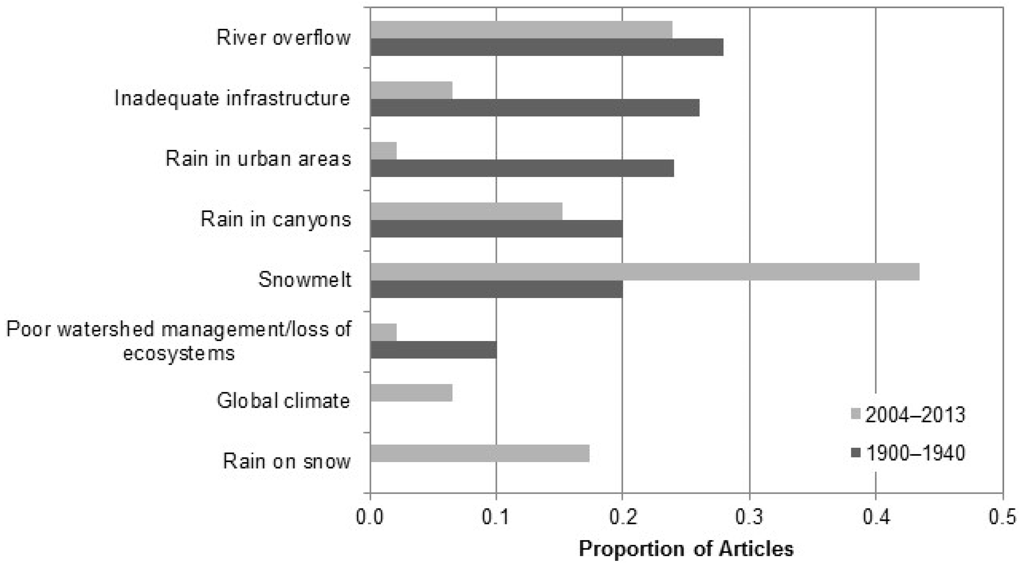
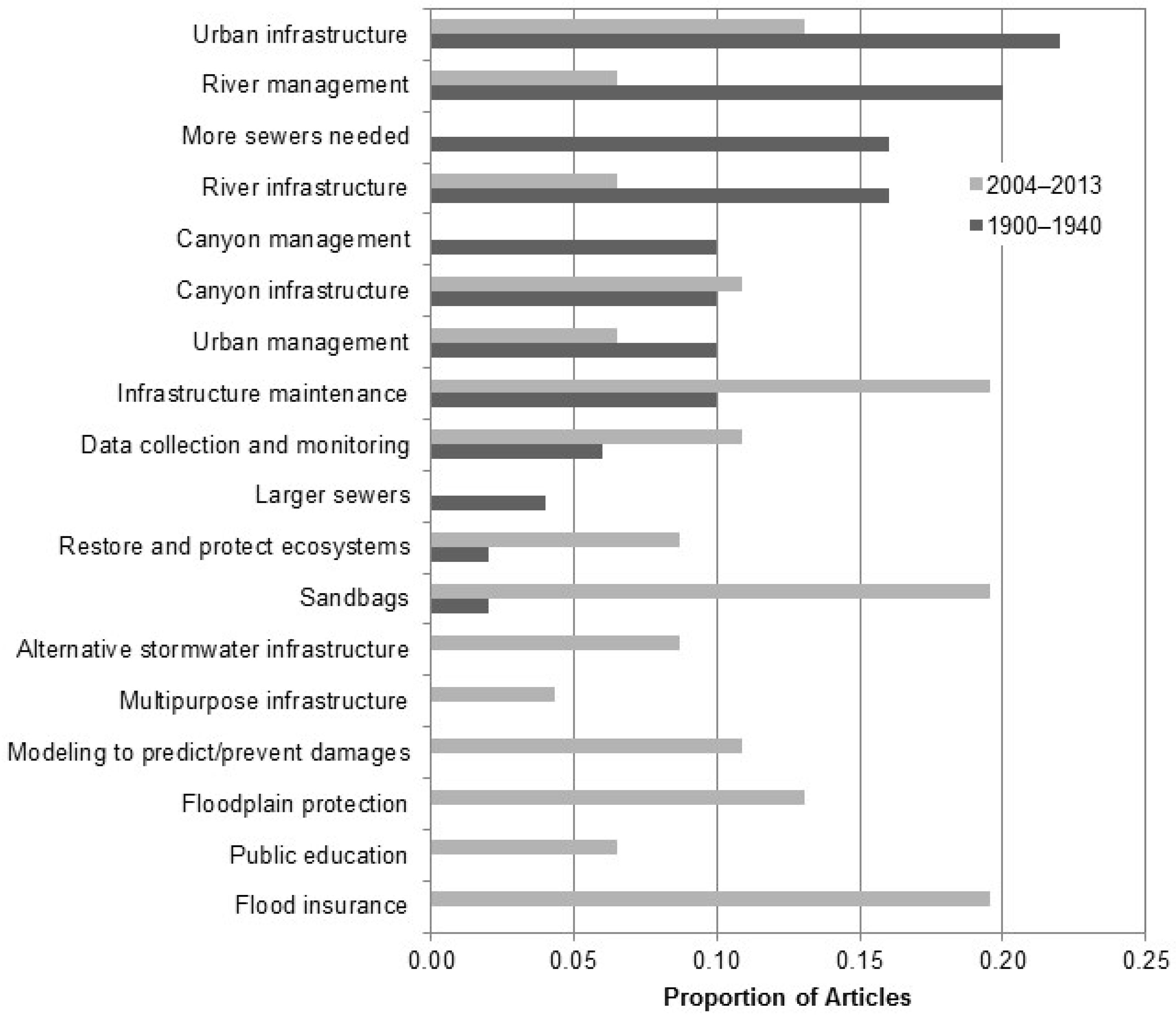
3.2. Research Question 2: Stormwater Management Paradigms in Salt Lake City

The media content analysis identified major shifts in problem definition, attributed causes of flooding and stormwater problems, solutions to address those problems, and constraints faced by Salt Lake City from the early 20th century to the early 21st century. How problems associated with flooding and stormwater were discussed in the media shifted from the early period to the more recent period (Figure 4). In the early period, from 1900 to 1940, 66% of coded articles discussed problems associated with flooding and stormwater, whereas only 44% of articles from the more recent period, 2004 to 2013, mentioned problems. The types of problems mentioned also differed between the two study periods (Figure 4). In the early period, the most frequently mentioned problems were that flooding and stormwater caused damages to private property (46%), flooded basements (36%), damages to public property (36%), and erosion and debris flows (22%). In contrast, news articles in the more recent period did not mention problems as often, yet there was a wider variety of problems mentioned compared to the early period. The most frequent problem mentioned remained damages to private property (20%). The other most frequently mentioned problems with flooding in the recent period was that it contaminated streams (11%), threatened the environment (9%), and caused injury or death (9%) (Figure 4).
The attribution of causes of flooding and stormwater problems also shifted over the study period (Figure 5). More articles in the first period discussed causes (76%) compared to the later period (54%). The most frequently mentioned causes in first period were river overflow (28%), inadequate infrastructure (26%), rain in urban areas (24%), rain in canyons (20%), and snowmelt (20%). Additionally mentioned was poor watershed management (10%). Early citations of poor watershed management were related to a recurring flood issues that caused mud and debris flows in the foothills of Salt Lake City in the early 1900s. These mud flows were particularly bad because of a combination of overgrazing and fire in the watershed above the city. In the more recent period, the most frequently mentioned cause of flooding was snowmelt (44%), followed by river overflow (24%), rain on snow (17%), and rain in canyons (15%).
Most of the articles in both periods (62% in the early period and 91% in the recent period) discussed solutions to address flooding and stormwater management problems in Salt Lake City (Figure 6). In the early period, the most frequently mentioned solutions to address flooding and stormwater were urban infrastructure (22%), river management (20%), more storm sewers (16%), and river infrastructure (16%). During this period, urban infrastructure included a centralized storm sewer system, and river management included the building of levees and dams to reduce river overflows. In the more recent period, the most frequently mentioned solutions included infrastructure maintenance (20%), largely preventing leaves and debris from clogging urban storm sewer intakes, the use of sandbags to protect private and public property (20%), and suggested changes to public behavior, such as the idea that businesses and homeowners should purchase flood insurance to protect their properties (20%). Other new solutions included the use of modeling to predict and prevent damages (10%) and protecting floodplains from development (13%, Figure 6).
Constraints were the least discussed category in both time periods, only 32% of articles in the early period and 28% of articles in the recent period mentioned constraints. In both periods, funding was the most commonly-mentioned constraint, 20% and 15% in the early and recent periods, respectively. However, conflicts over funding (e.g., funding sources, levels of funding) were rarely mentioned, only 2% and 7% of articles in the two periods. Issues with liability or jurisdiction were mentioned in 10% and 11% of articles in the two time periods. These included instances where jurisdiction over flood and stormwater management was unclear. Finally, about 4% of the articles in the first period and 2% of articles in the second time period mentioned inertia in changing stormwater and flood management in Salt Lake City. For example, a Salt Lake Telegram article in 1912 noted, “The question of storm sewers has been agitated for several years” [34].

4. Discussion

4.1. Moving to a More Nuanced Understanding of Urban Water Management Trajectories

Most importantly, the current pattern of infrastructure use across the three cities suggests that impervious surface area and stormwater infrastructure are decoupled across cities. Infrastructure is designed to manage runoff from impervious surfaces, so it might be expected that infrastructure density would be positively correlated with imperviousness across cities. However, I found that infrastructure density was consistently highest in the smallest, least impervious city. Therefore, studies that focus only on imperviousness are missing a critical component of urban hydrology, one that is not necessarily correlated with development. Although imperviousness is well correlated with hydrologic alteration in some studies [1,35,36,37], it may not be an effective predictor of urban hydrology across a wider range of urban contexts. This is particularly important for studies that forecast hydrologic implications of urbanization and interactions with climate change [38,39], as well as for understanding cross city variation [13].
There are several reasons why a smaller, younger city may have higher densities of stormwater infrastructure compared to an older, more established city. For one, newer cities with less impervious area may face fewer spatial constraints to implementing infrastructure projects. Retrofitting an area for infrastructure is likely to be more costly than implementing infrastructure during initial development, especially if installing storm sewer systems in an area that is already built up. Retrofitting an area with green infrastructure or detention basins is likely to be even more difficult because it essentially involves a land-use change [40,41] since existing infrastructure (including impervious surfaces) must be removed and space for retention-based infrastructure may not exist in already developed areas [12]. In addition to physical barriers, there may also be institutional barriers to infrastructure retrofits. Often changes in stormwater management infrastructure also require new regulatory and management frameworks [12,40,41], which might be more difficult to change in older more established cities than newly urbanizing areas. Indeed, variation in the density of detention basins across the three cities is likely related to differences in drainage standards for new development across the three cities. Logan and Salt Lake have the same standard: New development must not produce more than 0.2 cubic feet per second (cfs) of runoff per acre. In contrast, Heber has a stricter requirement of less than 0.1 cfs per acre. The importance of institutional barriers is particularly relevant within the context of broader frameworks for sustainable urban water management, which often suggest that management or infrastructure approaches are transferable across urban contexts. In Utah, strong prior appropriations law limits the use rainwater harvesting for either water reuse or reducing stormwater flow downstream [42,43]. As a result, forward-thinking frameworks, e.g., as mentioned in Reference [21], also need to evaluate the feasibility of proposed approaches across a wide range of cities.
In addition to current patterns of infrastructure, trajectories of infrastructure use varied across the three study cities. In particular, there were two distinct transition patterns, one followed by Salt Lake City, and a second followed by the two newer cities. Salt Lake City followed a characteristic transition that has been observed in other cities: the centralized storm sewer was developed in early city development followed by a shift to decentralized practices in the 1970s. This trajectory matches well with patterns observed in specific cities [5,20] and general descriptions of paradigm shifts [12,17,18,21]. Patterns of infrastructure use in the newer cities, however, did not fit this model. These cities had no need for extensive stormwater infrastructure in early 1900s; they were largely agricultural areas with limited development. In fact, these cities appeared to follow multiple paradigms at once. When these cities were reaching “urban” levels of imperviousness, the use of decentralized stormwater infrastructure, particularly detention basins, had become standard practice. Rather than transitioning from centralized to decentralized, these cities made use of both the current and older paradigms, combining decentralized detention basins and swales with storm sewers. As a result, Logan and Heber showed increase in all forms of infrastructure with urbanization. Again, this is critically important for understanding variations across cities and for making predictions about urban watershed function into the future. These results suggest that urbanization of small- and mid-sized cities in the United States could have very different consequences for hydrology and downstream ecosystems compared to current paradigms of urban hydrology [20,36] and urban streams [25,37] that are based on older and larger cities.
Earlier work has suggested that the time of urbanization is an important determinant of the type of stormwater infrastructure used in a particular location within a city [5,9,18]. However, the different trajectories followed by these three cities suggests that the time of urbanization for the city as a whole, rather than locations within a city, could determine the trajectory of infrastructure use. This is important because it presents a much more complex and nuanced picture of urban change than previous reviews which suggest that cities all follow similar or identical paths [17,18,20]. We know from urban metabolism studies that cities can follow different trajectories [23,44], yet it is particularly important to understand how and why stormwater infrastructure trajectories vary across cities. In a study of three older East-coast cities, Hopkins et al. [13] found that development intensity during peak growth was the best predictor of hydrologic changes due to urbanization and hypothesize that the period of peak urbanization controls hydrologic changes particularly by setting the dominant stormwater infrastructure and road network. As a result, infrastructure use trajectories can lend insight into not only structural but also functional variation across cities today.

4.2. Paradigm Shifts in Stormwater Management

The media content analysis revealed shifts in all aspects of management paradigms that paralleled observed shifts in infrastructure use in Salt Lake City. Problems shifted from a focus on property damage to more emphasis on environmental damage and an increased focus on water quality rather than just quantity. The causes of stormwater and flood problems cited in the news media also changed over time, shifting from rainfall and the lack of urban infrastructure to the dominance of snowmelt as a source of flooding. Similarly, range of solutions mentioned in the media broadened from the first to second period, with a shift from more structural solutions to behavioral (e.g., flood insurance, sandbags, modeling floods) and ecological (e.g., floodplain protection) solutions. Finally, in terms of constraints, the emergence of federal regulations, largely related to the Clean Water Act, was a major development by the second period that likely influenced other aspects of stormwater and flood management paradigms. These changes in management paradigms paralleled the trajectory of infrastructure use in Salt Lake City. Early focus on flood management and water quality in the early period was matched with use of storm sewers to remove flood and storm waters from the urban area. In the more recent period, the focus on water quality and discussion of more ecological and alternative solutions for stormwater management was matched by the dramatic increase in the use of detention and retention basins in the city.
While the analysis presented here does not address the causes of these changes, three general processes are suggested by the results and the existing literature. The first is that local scale paradigms mirror larger scale (e.g., national) trends, the second that the problems and solutions for stormwater management shifted because early problems were successfully addressed, and the third is that these changes were in response to local flooding events between the two study periods which catalyzed a paradigm shift. In reality, the changes documented here are likely due to a combination of these three processes.
The paradigm shifts observed in Salt Lake City mirror the larger trends in stormwater management presented in earlier studies. Other authors have noted that for stormwater management and urban hydrology in general, the problems and objectives of management have shifted over time, in particular from a single focus on reducing urban flooding to the inclusion of water quality and the effects of stormwater on the environment [12,17,18,20]. The solutions available for stormwater management have also changed at broad scales. Authors have noted shifts from conveyance to retention-based infrastructure and the use of infrastructure that meets broader sets of objectives, including recreation, pollution abatement, and sustainability, in addition to flood control [12,17,18,21,45]. The emergence of regulations, notably the EPA’s Phase I and II stormwater permit rules in 1990 and 1999, have been cited as a major driver of changes in the objectives of stormwater management, particularly the relatively recent focus on water quality [12,46]. For several reasons, it is to be expected that local paradigms of stormwater management should reflect broader scale patterns. Cities do not exist as independent entities; they exist within social and technological networks across which information flows are substantial [47]. Indeed, similarities in paradigm shifts across cities have been observed for other water management issues [48]. Furthermore, cities are subject to similar cross scale drivers; in the United States, federal requirements are an important example [12,47]. Yet other socioeconomic drivers can be important as well. For example, a major argument advanced for the development of the centralized storm sewer system in Salt Lake City was that it would provide work for the many men who were unemployed due to the Great Depression (e.g., [49]). The same processes occurred in Kansas City, where infrastructure projects, including for stormwater and flood control, were used as a stimulus measure [50]. Similarly, large scale social shifts may also be important, such as normative shifts in how people value the environment, which can shape the development of new technologies and vice versa [45,51].
The second potential processes driving changes in management paradigms in Salt Lake City could be that flooding problems declined due to the effectiveness of existing management and infrastructure, leading to the decline in the perception of flooding as a problem. It is likely that successful infrastructure improvements have lowered incidences of flooding. However, according to the NOAA National Climate Data Center Storm Event Database [52], flood damages in Salt Lake County from 1997 to 2014 totaled $5.8 million, suggesting that this problem has not been eliminated. As a result, it seems unlikely that major changes in the occurrence of hydrologic floods changed perceptions of flooding as a problem. Instead, what may have changed is the social construction of flooding. Previous work has shown that flood risk perceptions can change without any changes in physical risk due to political and economic processes [53]. In Quebec, Canada, Castonguay [53] documented increases in social perceptions of vulnerability to floods over time, as elites needed public support to regulate the river for industrial purposes. It is possible that the inverse process occurred in Salt Lake City. More in line with the directionality of my findings, Brugger and Crimmins [54] found a similar pattern in perceptions of climate change, notably, a shift from trying to “overcome” climate change to “living with the climate”. This approach of acknowledging environmental processes and the potential for hazards but approaching through adaptation rather than control, has parallels with perspectives in Salt Lake City. In particular, the use of models and sandbags to predict flooding and prevent damages, in combination with encouragement of residents and businesses to purchase flood insurance, suggest a more adaptive and accepting approach of living with flooding, rather than trying to control it.
Finally, paradigm shifts may also have been driven by local, rather than external, processes. In particular, management approaches may have changed in response to several large flooding events that occurred during the time between these two study periods. Major flooding events occurred in 1952, 1963, 1982, and 1983. Much research has been devoted to understanding responses to major floods and other hazards [55,56,57], and a key hypothesis in policy change is that major events or crises can create windows of opportunity for policy and institutional change [58,59,60]. Because this analysis is focused on two distinct periods before and after these floods, more research is needed to understand the dynamics of paradigm transitions in the interim period. The likelihood is that the paradigm shifts observed here were due to the individual and interactive effects of many social, physical, and technological processes at local to global scales.

5. Conclusions

Even across three cities with similar social and ecological context, stormwater infrastructure use, in terms of design and density, was variable across cities and within cities over time. A clear understanding of the factors driving variation in stormwater infrastructure use is lacking, highlighting the need for similar studies with large sample sizes. However, it is clear from these three cities that land cover change and hydrologic engineering are not parallel processes and that the ways in which cities are drained need to be taken into account in order to accurately understand and make predictions about urban hydrology. Future studies are needed to link spatiotemporal patterns of infrastructure use with analysis of drivers (e.g., planning policies) and hydrologic outcomes to design our cities to be resilient and adaptable to climate change and population growth.
It is clear from this and previous work that the paradigms that guide decision-making about urban infrastructure have changed significantly over the past 100 years, with major shifts in the goals and solution space for stormwater management. Importantly, local paradigm shifts are variable, but they are certainly linked to larger scale trends. For example, the emergence of federal regulations can change local dialogue about problems and solutions. This highlights the importance of understanding historical context of each individual city, as well as the difficulty in projecting or predicting future changes in urban infrastructure. Our decisions about how to manage our cities in the future may be based on novel paradigms that we may or may not be able to anticipate. Importantly, while there is evidence that larger scale trends influence local paradigms, there remains the variation in infrastructure trajectories across these three study cities. This suggests that overall, broad paradigms seem influence all three cities, but newer cities follow different trajectories. In this case, there is some evidence for the idea of leap-frog development, where newer cities skip initial development stages, and yet there is also evidence that new cities are also playing catch up—building conveyance as well as retention infrastructure—and borrowing from multiple paradigms. Future work is needed to explore the dynamics of management paradigms in these newer cities. Ultimately, how cities are designed, including urban infrastructure, is a reflection of how humans see the world: What problems are being addressed and what the best available solutions are. There have been major changes over time in how urban problems are defined and addressed, and these changes have created heterogeneity within and across cities as cities develop.

Acknowledgments

This work was supported by the National Science Foundation under EPSCoR grant IIA 1208732 awarded to Utah State University, as part of the State of Utah EPSCoR Research Infrastructure Improvement Award. I especially want to thank Diane Pataki for providing feedback on this work throughout the research process, Salt Lake County, the City of Logan, and Heber City for sharing data on stormwater infrastructure, and Salt Lake, Wasatch, and Cache Counties for sharing parcel data. This manuscript was greatly improved with comments from Meghan Avolio, Elizabeth Cook, and four anonymous reviewers.

Conflicts of Interest

The author declares no conflict of interest.

References

  1. Arnold, C.L.; Gibbons, C.J. Impervious surface coverage—The emergence of a key environmental indicator. J. Am. Plan. Assoc. 1996, 62, 243–258. [Google Scholar] [CrossRef]
  2. Elmore, A.J.; Kaushal, S.S. Disappearing headwaters: Patterns of stream burial due to urbanization. Front. Ecol. Environ. 2008, 6, 308–312. [Google Scholar] [CrossRef]
  3. Steele, M.K.; Heffernan, J.B.; Bettez, N.; Cavender-Bares, J.; Groffman, P.M.; Grove, J.M.; Hall, S.; Hobbie, S.E.; Larson, K.; Morse, J.L.; et al. Convergent surface water distributions in U.S. cities. Ecosystems 2014, 17, 685–697. [Google Scholar] [CrossRef] [Green Version]
  4. Hopkins, K.G.; Bain, D.J.; Copeland, E.M. Reconstruction of a century of landscape modification and hydrologic change in a small urban watershed in Pittsburgh, PA. Landsc. Ecol. 2014, 29, 413–424. [Google Scholar] [CrossRef]
  5. Hale, R.L.; Turnbull, L.; Earl, S.R.; Childers, D.L.; Grimm, N.B. Stormwater infrastructure controls runoff and dissolved material export from arid urban watersheds. Ecosystems 2015, 18, 62–75. [Google Scholar] [CrossRef] [Green Version]
  6. Johnson, T.A.N.; Kaushal, S.S.; Mayer, P.M.; Grese, M.M. Effects of stormwater management and stream restoration on watershed nitrogen retention. Biogeochemistry 2014, 121, 81–106. [Google Scholar] [CrossRef]
  7. Hatt, B.E.; Fletcher, T.D.; Walsh, C.J.; Taylor, S.L. The influence of urban density and drainage infrastructure on the concentrations and loads of pollutants in small streams. Environ. Manag. 2004, 34, 112–124. [Google Scholar] [CrossRef] [PubMed]
  8. Larson, E.K.; Grimm, N.B. Small-scale and extensive hydrogeomorphic modification and water redistribution in a desert city and implications for regional nitrogen removal. Urban Ecosyst. 2012, 15, 71–85. [Google Scholar] [CrossRef]
  9. Meierdiercks, K.L.; Smith, J.A.; Baeck, M.L.; Miller, A.J. Analyses of urban drainage network structure and its impact on hydrologic response. J. Am. Water Resour. Assoc. 2010, 46, 932–943. [Google Scholar] [CrossRef]
  10. Paul, M.J.; Meyer, J.L. Streams in the urban landscape. Annu. Rev. Ecol. Syst. 2001, 32, 333–365. [Google Scholar] [CrossRef]
  11. Ashley, R.M.; Balmforth, D.J.; Saul, A.J.; Blanskby, J.D. Flooding in the future-predicting climate change, risks and responses in urban areas. Water Sci. Technol. 2005, 52, 265–273. [Google Scholar] [PubMed]
  12. Roy, A.; Wenger, S.; Fletcher, T.; Walsh, C.; Ladson, A.; Shuster, W.; Thurston, H.; Brown, R. Impediments and solutions to sustainable, watershed-scale urban stormwater management: Lessons from Australia and the United States. Environ. Manag. 2008, 42, 344–359. [Google Scholar] [CrossRef] [PubMed]
  13. Hopkins, K.G.; Morse, N.B.; Bain, D.J.; Bettez, N.D.; Grimm, N.B.; Morse, J.L.; Palta, M.M. Type and timing of stream flow changes in urbanizing watersheds in the Eastern U.S. Elem. Sci. Anthr. 2015, 3, 56. [Google Scholar] [CrossRef]
  14. Denault, C.; Millar, R.; Lence, B. Assessment of possible impacts of climate change in an urban catchment. J. Am. Water Resour. Assoc. 2006, 42, 685–697. [Google Scholar] [CrossRef]
  15. Forsee, W.; Ahmad, S. Evaluating Urban Storm-Water Infrastructure Design in Response to Projected Climate Change. J. Hydrol. Eng. 2011, 16, 865–873. [Google Scholar] [CrossRef]
  16. Burian, S.J.; Nix, S.J.; Pitt, R.E.; Durrans, S.R. Urban Wastewater Management in the United States: Past, Present, and Future. J. Urban Technol. 2000, 7, 33–62. [Google Scholar] [CrossRef]
  17. Chocat, B.; Krebs, P.; Marsalek, J.; Rauch, W.; Schilling, W. Urban drainage redefined: From stormwater removal to integrated management. Water Sci. Technol. 2001, 43, 61–68. [Google Scholar] [PubMed]
  18. Delleur, J.W. The Evolution of Urban Hydrology: Past, Present, and Future. J. Hydraul. Eng. 2003, 129, 563–573. [Google Scholar] [CrossRef]
  19. Brown, R.R.; Farrelly, M.A.; Loorbach, D.A. Actors working the institutions in sustainability transitions: The case of Melbourne’s stormwater management. Glob. Environ. Chang. 2013, 23, 701–718. [Google Scholar] [CrossRef]
  20. Kaushal, S.S.; McDowell, W.H.; Wollheim, W.M.; Johnson, T.A.N.; Mayer, P.M.; Belt, K.T.; Pennino, M.J. Urban Evolution: The Role of water. Water 2015, 7, 4063–4087. [Google Scholar] [CrossRef]
  21. Wong, T.H.F.; Brown, R.R. The water sensitive city: Principles for practice. Water Sci. Technol. 2009, 60, 673–682. [Google Scholar] [CrossRef] [PubMed]
  22. Groffman, P.M.; Cavender-Bares, J.; Bettez, N.D.; Grove, J.M.; Hall, S.J.; Heffernan, J.B.; Hobbie, S.E.; Larson, K.L.; Morse, J.L.; Neill, C.; et al. Ecological homogenization of urban USA. Front. Ecol. Environ. 2014, 12, 74–81. [Google Scholar] [CrossRef]
  23. Kennedy, C.; Cuddihy, J.; Engel-Yan, J. The changing metabolism of cities. J. Ind. Ecol. 2007, 11, 43–59. [Google Scholar] [CrossRef]
  24. York, A.M.; Shrestha, M.; Boone, C.G.; Zhang, S.; Harrington, J.A.; Prebyl, T.J.; Swann, A.; Agar, M.; Antolin, M.F.; Nolen, B.; et al. Land fragmentation under rapid urbanization: A cross-site analysis of Southwestern cities. Urban Ecosyst. 2011, 14, 429–455. [Google Scholar] [CrossRef]
  25. Parr, T.B.; Smucker, N.J.; Neale, M.W.; Bentsen, C.N. Potential roles of past, present, and future urbanization characteristics in producing varied stream responses. Freshw. Sci. 2016, 35, 436–443. [Google Scholar] [CrossRef]
  26. Brown, L.R.; Cuffney, T.F.; Coles, J.F.; Fitzpatrick, F.; McMahon, G.; Steuer, J.; Bell, A.H.; May, J.T. Urban streams across the USA: Lessons learned from studies in 9 metropolitan areas. J. N. Am. Benthol. Soc. 2009, 28, 1051–1069. [Google Scholar] [CrossRef]
  27. US Census Bureau 2010 Census Urban and Rural Classification and Urban Area Criteria. Available online: https://www.census.gov/geo/reference/ua/urban-rural-2010.html (accessed on 15 July 2016).
  28. Governor’s Office of Planning and Budget, 2012 Baseline Projections. Available online: http://gomb.utah.gov/wp-content/uploads/sites/7/2013/08/Population-by-Age-and-Area.xlsx (accessed on 15 July 2016).
  29. Armstrong, A. Organizational Adaptation in Local Stormwater Governance. Ph.D. Thesis, Utah State University, Logan, UT, USA, 2015. [Google Scholar]
  30. Xian, G.; Homer, C.; Dewitz, J.; Fry, J.; Hossain, N.; Wickham, J. Change of impervious surface area between 2001 and 2006 in the conterminous United States. Photogramm. Eng. Remote Sens. 2011, 77, 758–762. [Google Scholar]
  31. Homer, C.G.; Dewitz, J.A.; Yang, L.; Jin, S.; Danielson, P.; Xian, G.; Coulston, J.; Herold, N.D.; Wickham, J.D.; Megown, K. Completion of the 2011 National Land Cover Database for the conterminous United States—Representing a decade of land cover change information. Photogramm. Eng. Remote Sens. 2015, 81, 345–354. [Google Scholar]
  32. Crawley, C.E. Localized Debates of Agricultural Biotechnology in Community Newspapers: A Quantitative Content Analysis of Media Frames and Sources. Sci. Commun. 2007, 28, 314–346. [Google Scholar] [CrossRef]
  33. Utah Digital Newspapers-Home. Available online: http://digitalnewspapers.org/ (accessed on 15 July 2016).
  34. Unusual Rainfall Hits City. Available online: https://newspapers.lib.utah.edu/pdfjs/web/viewer.html?file=/udnfiles/fe/c3/fec3e97622dc6aee592e2f956b652926036aeb9e.pdf (accessed on 20 July 2016).
  35. Schueler, T.R.; Fraley-McNeal, L.; Cappiella, K. Is Impervious Cover Still Important? Review of Recent Research. J. Hydrol. Eng. 2009, 14, 309–315. [Google Scholar] [CrossRef]
  36. Shuster, W.D.; Bonta, J.; Thurston, H.; Warnemuende, E.; Smith, D.R. Impacts of impervious surface on watershed hydrology: A review. Urban Water J. 2005, 2, 263–275. [Google Scholar] [CrossRef]
  37. Walsh, C.J.; Roy, A.H.; Feminella, J.W.; Cottingham, P.D.; Groffman, P.M.; Morgan, R.P. The urban stream syndrome: Current knowledge and the search for a cure. J. N. Am. Benthol. Soc. 2005, 24, 706–723. [Google Scholar] [CrossRef]
  38. Knouft, J.H.; Chu, M.L. Using watershed-scale hydrological models to predict the impacts of increasing urbanization on freshwater fish assemblages. Ecohydrology 2015, 8, 273–285. [Google Scholar] [CrossRef]
  39. Nelson, K.C.; Palmer, M.A.; Pizzuto, J.E.; Moglen, G.E.; Angermeier, P.L.; Hilderbrand, R.H.; Dettinger, M.; Hayhoe, K. Forecasting the combined effects of urbanization and climate change on stream ecosystems: From impacts to management options. J. Appl. Ecol. 2009, 46, 154–163. [Google Scholar] [CrossRef] [PubMed]
  40. Brown, R.; Farrelly, M. Challenges ahead: Social and institutional factors influencing sustainable urban stormwater management in Australia. Water Sci. Technol. 2009, 59, 653–660. [Google Scholar] [CrossRef] [PubMed]
  41. Keeley, M.; Koburger, A.; Dolowitz, D.P.; Medearis, D.; Nickel, D.; Shuster, W. Perspectives on the Use of Green Infrastructure for Stormwater Management in Cleveland and Milwaukee. Environ. Manag. 2013, 51, 1093–1108. [Google Scholar] [CrossRef] [PubMed]
  42. Findlay, D. Rainwater collection, water law, and climate change: A flood of problems waiting to happen. NC J. Law Technol. 2008, 10, 74. [Google Scholar]
  43. Cummings, K. Adapting to Water Scarcity: A Comparative Analysis of Water Harvesting Regulation in the Four Corner States. J. Environ. Law Litig. 2012, 27, 539. [Google Scholar]
  44. Decker, E.H.; Elliott, S.; Smith, F.; Blake, D.R.; Rowland, F.S. Energy and material flow through the urban ecosystem. Annu. Rev. Energy Environ. 2000, 25, 685–740. [Google Scholar] [CrossRef]
  45. Brown, R.R.; Keath, N.; Wong, T.H.F. Urban water management in cities: Historical, current and future regimes. Water Sci. Technol. J. Int. Assoc. Water Pollut. Res. 2009, 59, 847–855. [Google Scholar] [CrossRef] [PubMed]
  46. National Research Council (NRC). Urban Stormwater Management in the United States; National Academies Press: Washington, DC, USA, 2008. [Google Scholar]
  47. Ernstson, H.; van der Leeuw, S.E.; Redman, C.L.; Meffert, D.J.; Davis, G.; Alfsen, C.; Elmqvist, T. Urban Transitions: On Urban Resilience and Human-Dominated Ecosystems. Ambio 2010, 39, 531–545. [Google Scholar] [CrossRef] [PubMed]
  48. Durand, C.; Dagenais, M. Cleaning, Draining, and Sanitizing the City: Conceptions and Uses of Water in the Montreal Region. Can. Hist. Rev. 2006, 87, 621–651. [Google Scholar]
  49. City Prepares for Work on Storm Sewer. Available online: https://newspapers.lib.utah.edu/pdfjs/web/viewer.html?file=/udnfiles/a1/ed/a1ed3770fca69712be40d91873fd72132c537bd5.pdf (accessed on 20 July 2016).
  50. Driever, S.L.; Vaughn, D.M. Flood Hazard in Kansas City since 1880. Geogr. Rev. 1988, 78, 1–19. [Google Scholar] [CrossRef]
  51. Frantzeskaki, N.; Loorbach, D. Towards governing infrasystem transitions: Reinforcing lock-in or facilitating change? Technol. Forecast. Soc. Chang. 2010, 77, 1292–1301. [Google Scholar] [CrossRef]
  52. NCDC Storm Events Database-Data.gov. Available online: https://catalog.data.gov/dataset/ncdc-storm-events-database (accessed on 15 July 2016).
  53. Castonguay, S. The Production of Flood as Natural Catastrophe: Extreme Events and the Construction of Vulnerability in the Drainage Basin of the St. Francis River (Quebec), Mid-Nineteenth to Mid-Twentieth Century. Environ. Hist. 2007, 12, 820–844. [Google Scholar] [CrossRef]
  54. Brugger, J.; Crimmins, M. The art of adaptation: Living with climate change in the rural American Southwest. Glob. Environ. Chang. 2013, 23, 1830–1840. [Google Scholar] [CrossRef]
  55. Buckland, J.; Rahman, M. Community-based disaster management during the 1997 Red River Flood in Canada. Disasters 1999, 23, 174–191. [Google Scholar] [CrossRef] [PubMed]
  56. Hearne, R.R. Evolving water management institutions in the Red River basin. Environ. Manag. 2007, 40, 842–852. [Google Scholar] [CrossRef] [PubMed]
  57. Simonovic, S.P.; Carson, R.W. Flooding in the Red River Basin–Lessons from Post Flood Activities. Nat. Hazards 2003, 28, 345–365. [Google Scholar] [CrossRef]
  58. Baumgartner, F.R. Punctuated Equilibrium Theory and Environmental Policy. In Punctuated Equilibrium and the Dynamics of U.S. Environmental Policy; Yale University Press: New Haven, CT, USA, 2006; pp. 24–46. [Google Scholar]
  59. Meijerink, S. Understanding policy stability and change the interplay of advocacy coalitions and epistemic communities, windows of opportunity, and Dutch coastal flooding policy 1945–2003 1. J. Eur. Public Policy 2005, 12, 1060–1077. [Google Scholar] [CrossRef]
  60. Sabatier, P. An Advocacy Coalition Framework of Policy Change and the Role of Policy-Oriented Learning Therein. In Public Policy Theories, Models, and Concepts; Prentice Hall: Englewood Cliffs, NJ, USA, 1995; pp. 339–379. [Google Scholar]
Figure 1. Location and imperviousness of three study cities. Imperviousness data from 2011 National Land Cover Database [30].
Water 08 00310 g001
Figure 2. Annual infrastructure use (new infrastructure normalized by new development), population, and imperviousness (%) for Salt Lake City, Logan, and Heber City, UT from 1900 to 2010.
Water 08 00310 g002
Figure 3. Changes in infrastructure density with % imperviousness (a proxy for urbanization) in Salt Lake City, Logan, and Heber City, UT.
Water 08 00310 g003
Figure 4. Problems associated with flooding and stormwater during two periods as mentioned in the Salt Lake City news media.
Water 08 00310 g004
Figure 5. Causes of flooding and stormwater problems during two periods as mentioned in the Salt Lake City news media.
Water 08 00310 g005
Figure 6. Solutions proposed to address flooding and stormwater during two periods as mentioned in the Salt Lake City news media.
Water 08 00310 g006
Table 1. Characteristics of three study cities.
CharacteristicsSalt Lake CityLoganHeber City
Population (2013)191,18048,91312,911
First settled184718591859
Average Annual Population Growth˗˗˗
1900 to 19504.80%4.18%1.40%
1950 to 20000.00%3.08%2.96%
2000 to 20140.14%0.14%1.43%
Decade with fastest growth rate1900 (73%)1950 (42%)2000 (56%)
City stormwater managementPublic UtilitiesPublic WorksCity Engineering
Impact fees for stormwater (per single family unit)$374$306$0
Impervious surface (%, 2011)544031

