
Modeling Typhoon‐Induced Alterations on River Sediment Transport and Turbidity Based on Dynamic Landslide Inventories: Gaoping River Basin, Taiwan


Abstract
:
1. Introduction
2. Materials and Methods
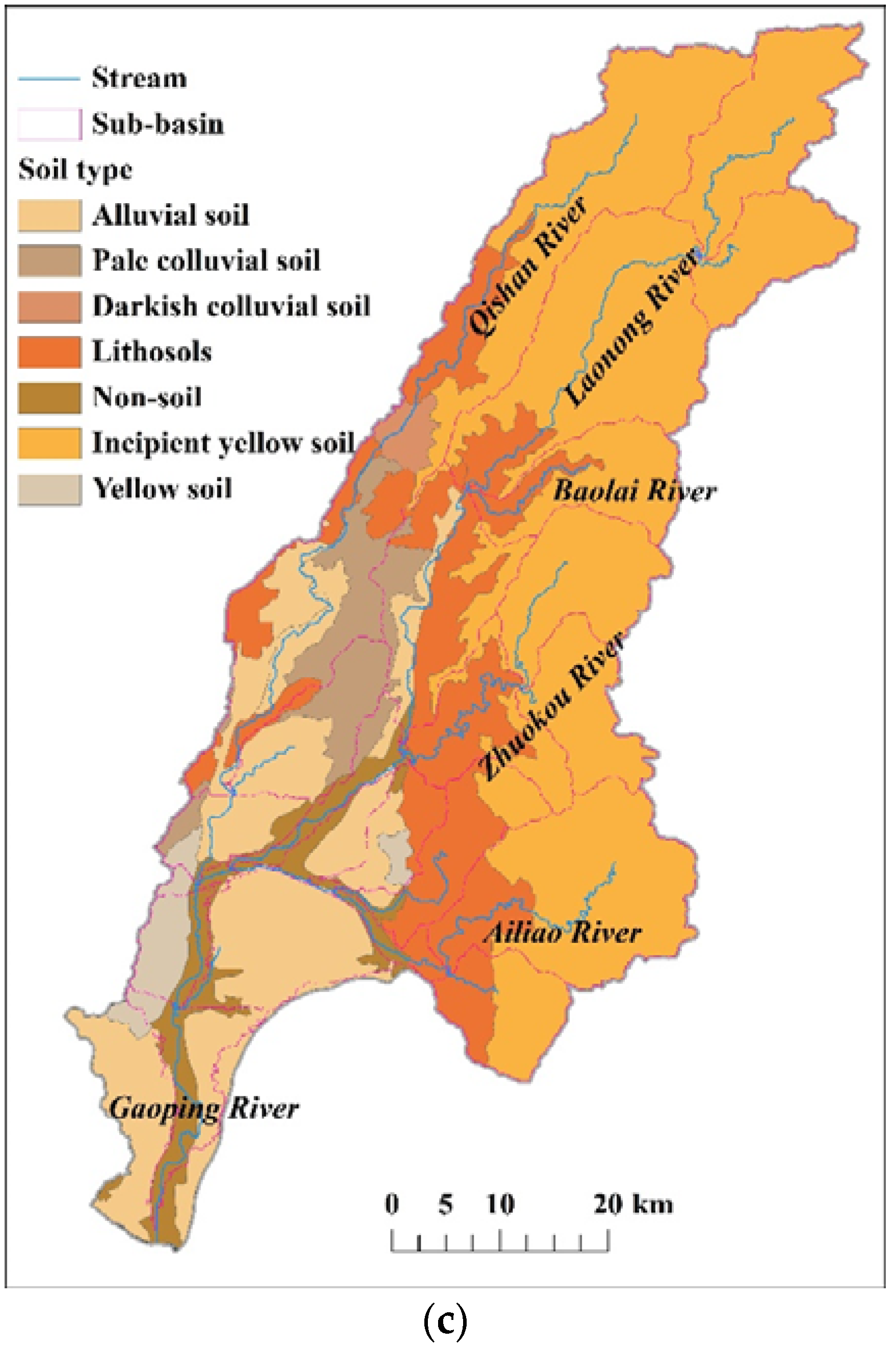
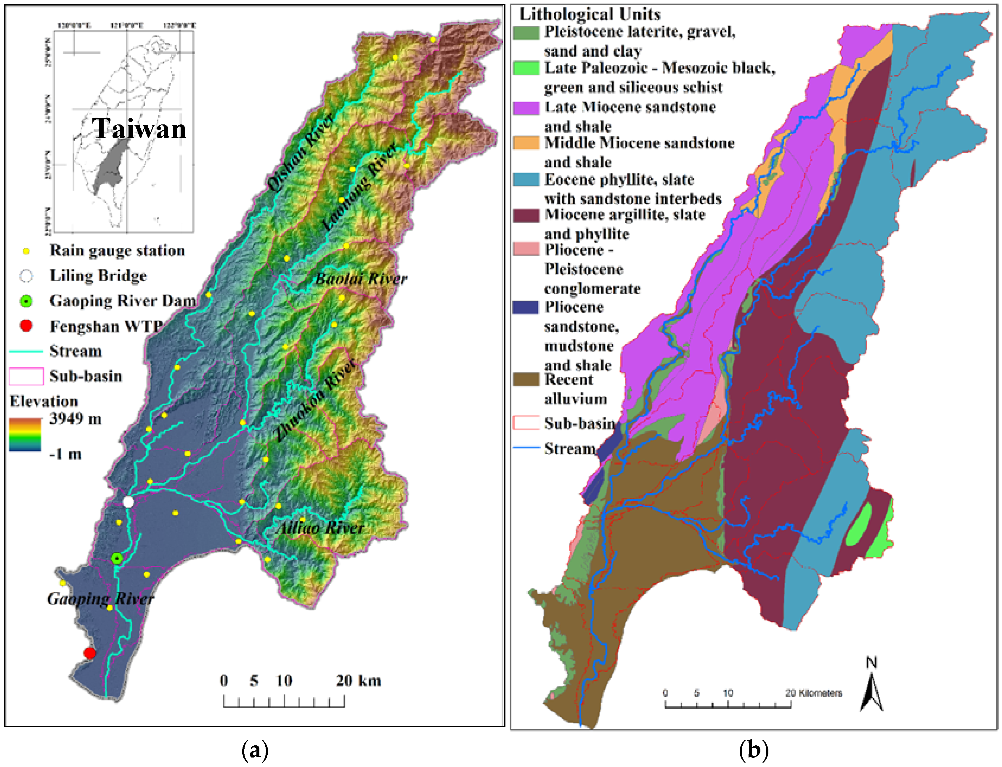
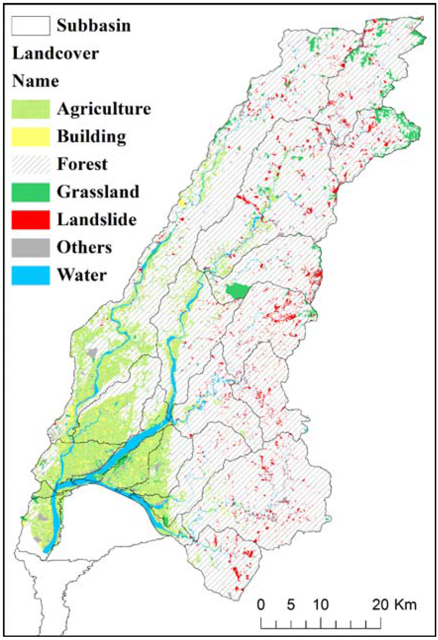
2.1. Study Area

2.2. Data Collection
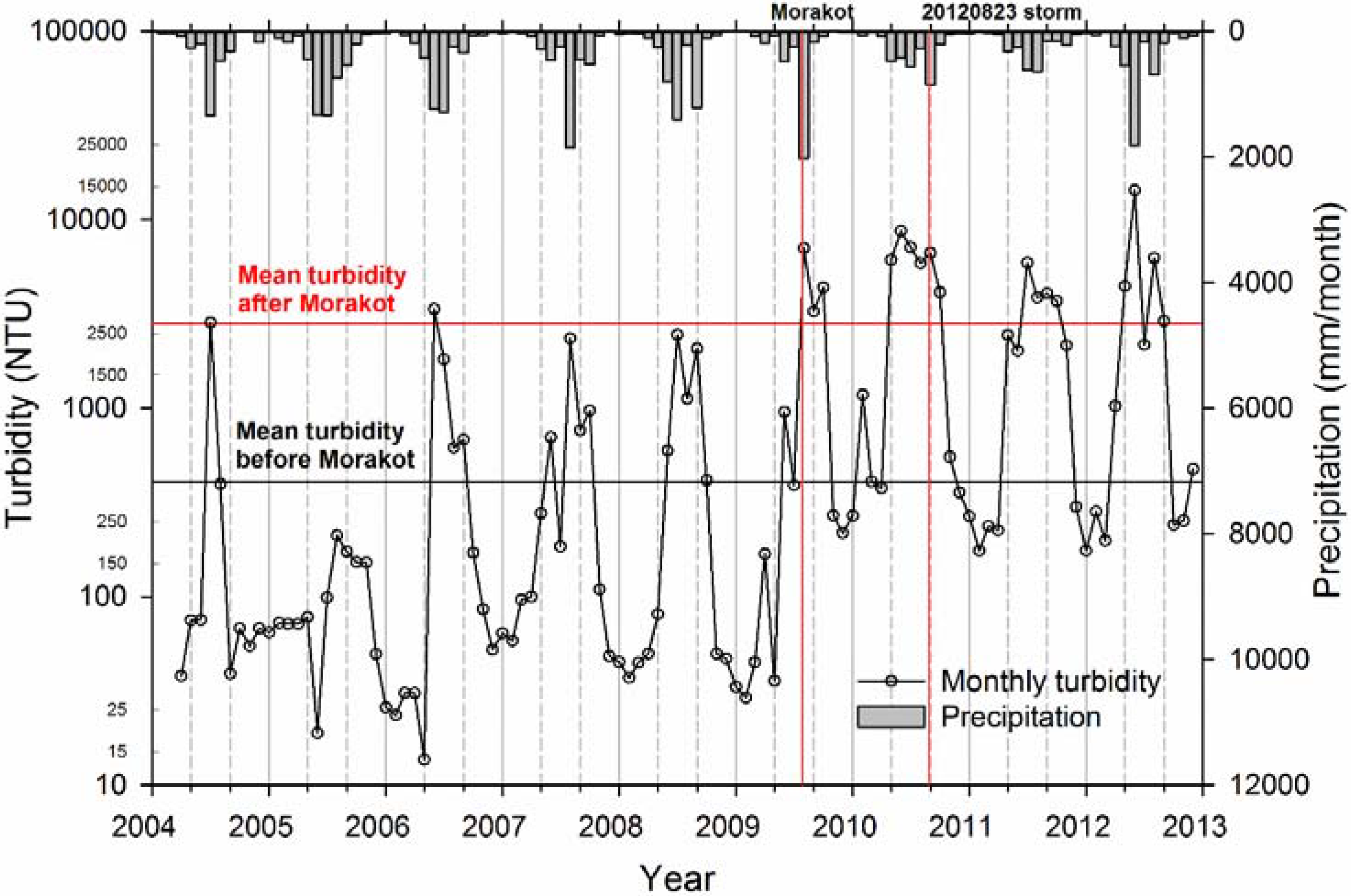
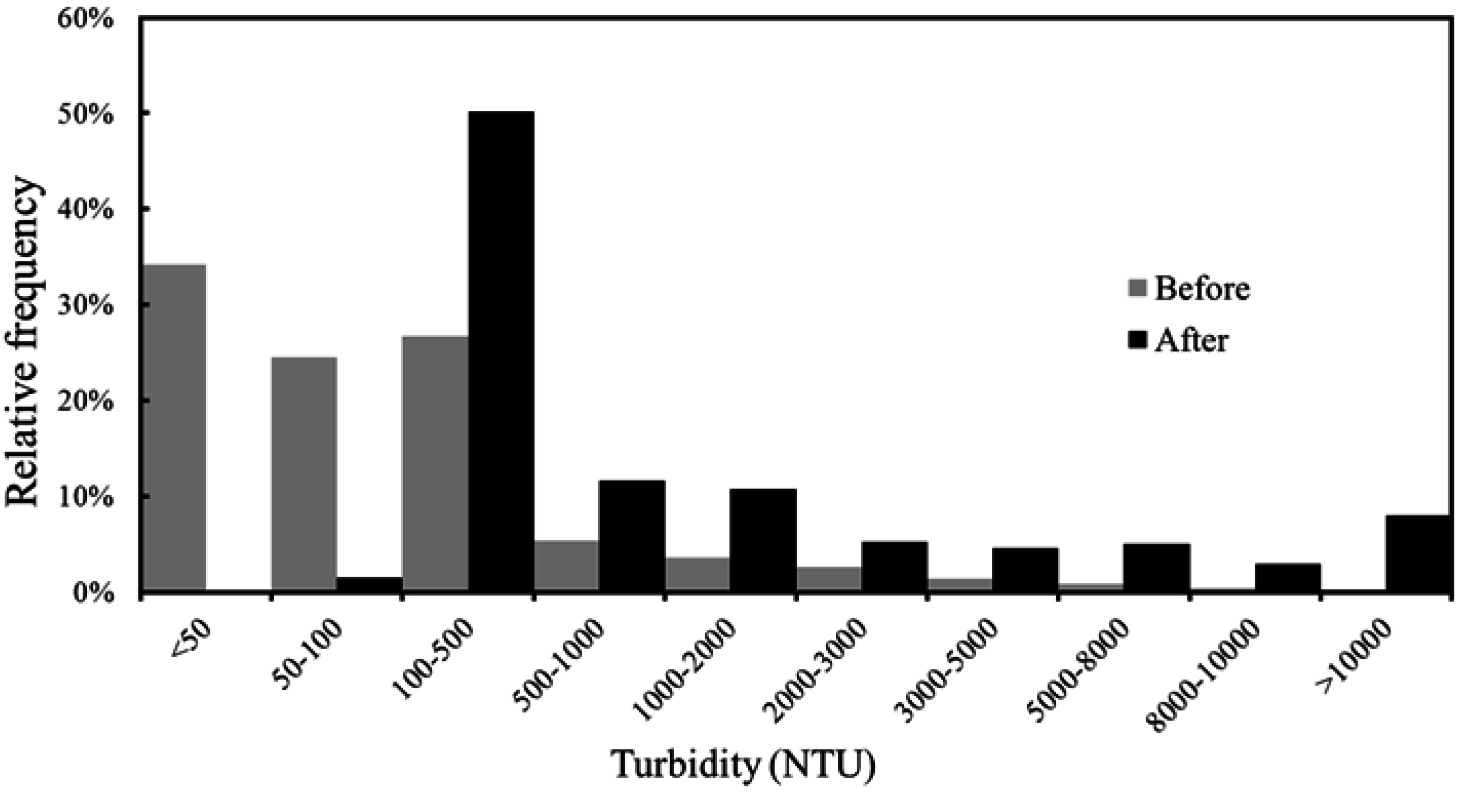
2.2.1. Turbidity
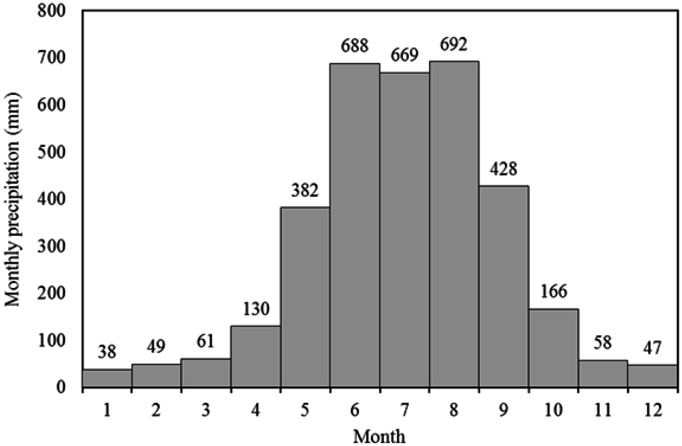
2.2.2. Precipitation

| Year | Precipitation (mm) | Land Cover Ratio (%) | ||||||
|---|---|---|---|---|---|---|---|---|
| Forest | Agriculture | Grassland | Water | Building | Landslide | Others | ||
| 1998 | 3388 | * | ||||||
| 1999 | 3030 | |||||||
| 2000 | 2986 | |||||||
| 2001 | 4133 | |||||||
| 2002 | 2015 | |||||||
| 2003 | 2101 | |||||||
| 2004 | 2960 | 70.8 | 14.5 | 2.1 | 4.7 | 3.1 | 2.5 | 2.3 |
| 2005 | 5069 | 70.3 | 14.5 | 2.0 | 4.7 | 3.1 | 3.2 | 2.2 |
| 2006 | 3965 | 70.2 | 14.5 | 2.0 | 4.7 | 3.1 | 3.4 | 2.1 |
| 2007 | 4110 | 70.2 | 14.5 | 2.0 | 4.7 | 3.1 | 3.3 | 2.2 |
| 2008 | 4325 | 70.0 | 14.5 | 2.0 | 4.6 | 3.1 | 3.5 | 2.3 |
| 2009 | 3406 | 70.4 | 14.5 | 2.0 | 4.7 | 3.1 | 3.0 | 2.3 |
| 2010 | 3074 | 66.2 | 14.3 | 1.4 | 4.5 | 3.1 | 8.2 | 2.3 |
| 2011 | 2550 | 67.6 | 14.4 | 1.6 | 4.5 | 3.1 | 6.5 | 2.3 |
| 2012 | 3989 | 67.9 | 14.4 | 1.7 | 4.5 | 3.1 | 6.2 | 2.2 |
| Average | 3407 | 69.3 | 15.1 | 1.9 | 4.6 | 3.1 | 4.4 | 0.8 |
2.2.3. River Discharge and Suspended Sediment Load
2.2.4. Inventory of Landslides
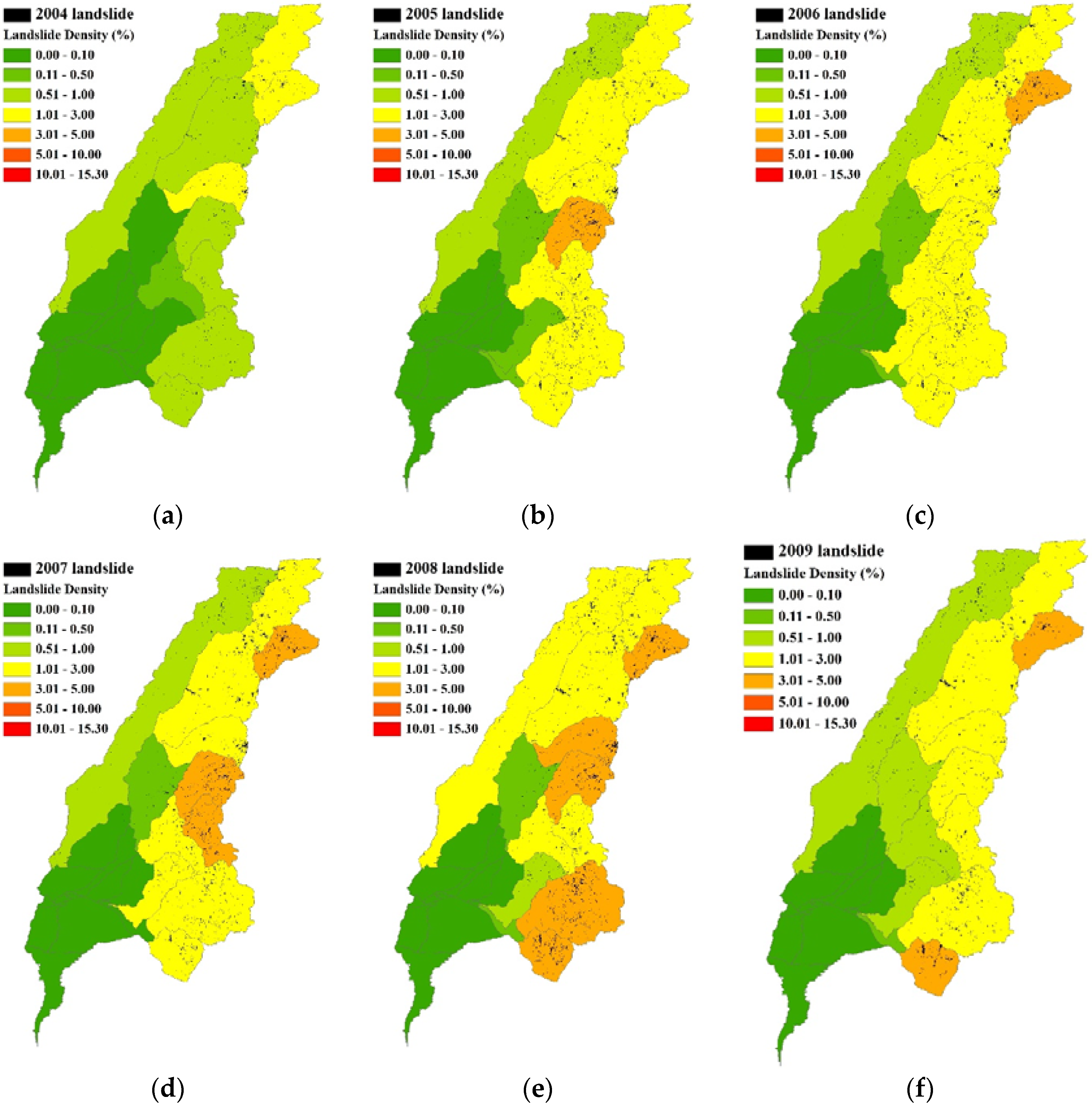

2.3. Landslide Updating
2.4. SWAT
| Sensitivity Ranking | Parameter | Process | Recommended Range | Values Calibrated by NSCE | Values Calibrated by Log-RMSE | Parameter Description |
|---|---|---|---|---|---|---|
| 1 | SPCON | Sediment from channels | 0.0001–0.01 | 0.002 | 0.009 | Linear parameter for calculating the maximum amount of sediment that can be re-entrained during channel sediment routing (Equation (2)) |
| 2 | PUSLE | Sediment from landscape | 0–1 | 0.846 | 0.966 | USLE equation support practice factor (Equation (1)) |
| 3 | CH_N(2) | Channel flow | 0.025–0.15 | 0.048 | 0.065 | Manning coefficient for the main channel |
| 4 | CN2 | Surface runoff | ±25% | ±0.81% | ±2.54% | Tuning range for the compensation of initial curve number settings at moisture condition II |
| 5 | SURLAG | Surface runoff | 0–10 | 0.623 | 3.31 | Surface runoff lag coefficient |
| 6 | Slope | Sediment from landscape | ±25% | ±0% | ±0% | Range for the fluctuation of initial average slope steepness (m/m) |
| 7 | SPEXP | Sediment from channels | 1.0–2.0 | 1.113 | 1.732 | Exponent parameter for calculating sediment re-entrained in channel sediment routing (Equation (2)) |
2.5. Objective Functions
3. Results and Discussion
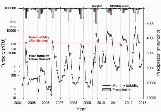
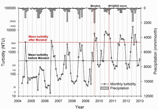
3.1. The Alterations in Turbidity and Sediment Regimes after Typhoon Morakot
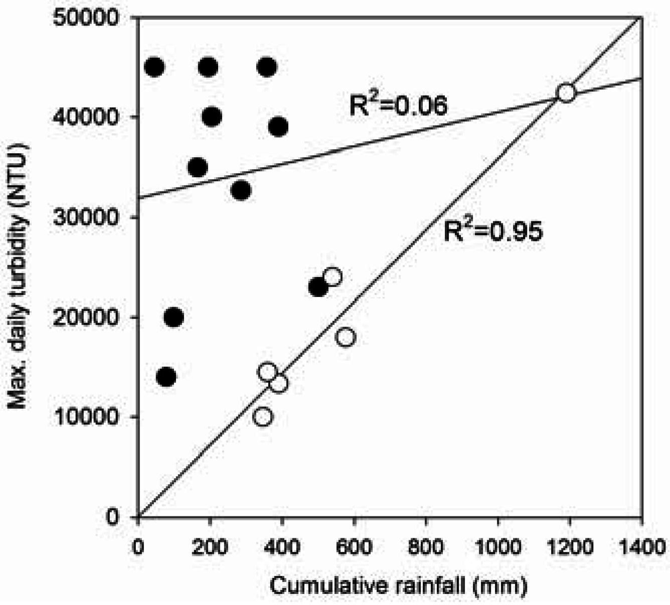
3.1.1. Turbidity
| Event | Date * | Cumulative Rainfall (mm) | Duration (Day) | Max. 24-h Rainfall (mm) | Max. Daily Turbidity (NTU) |
|---|---|---|---|---|---|
| Talim | 21 June 2012 | 644 | 7 | 358 | 45,000 |
| 0726 storm | 29 July 2010 | 569 | 10 | 194 | 45,000 |
| 0522 storm | 24 May 2010 | 133 | 5 | 45 | 45,000 |
| Morakot | 9 August 2009 | 2489 | 7 | 1190 | 42,400 ** |
| 0829 storm | 30 August 2011 | 450 | 5 | 204 | 40,000 |
| 0610 storm | 13 June 2012 | 1366 | 8 | 389 | 39,000 |
| 0529 storm | 30 May 2010 | 334 | 4 | 165 | 35,000 |
| 0719 storm | 19 July 2011 | 643 | 6 | 286 | 32,700 |
| Kalmaegi | 18 July 2008 | 1043 | 3 | 540 | 24,000 |
| Fanapi | 21 September 2010 | 524 | 2 | 501 | 23,000 |
| 0803 storm | 6 August 2010 | 158 | 3 | 98 | 18,500 |
| Mindulle | 4 July 2004 | 1667 | 6 | 577 | 18,000 |
| Sepat | 19 August 2007 | 1032 | 6 | 360 | 14,500 |
| Tembin | 29 August 2012 | 165 | 5 | 78 | 14,000 |
| 0609 storm | 10 June 2006 | 1063 | 9 | 390 | 13,360 |
| Fungwong | 29 July 2008 | 525 | 2 | 347 | 10,000 |
| Event | Date | Cumulative Rainfall (mm) | Duration (Day) | Max. 24-h Rainfall (mm) | Peak Daily Discharge (CMS) | Contribution Ratio * (%) |
|---|---|---|---|---|---|---|
| Morakot | 9 August | 2489 | 7 | 1190 | 15,252 | 93 |
| Haitang | 5 July | 1574 | 4 | 616 | - | 47 |
| Mindulle | 4 July | 1667 | 6 | 577 | 10,007 | 80 |
| Talim | 5 September | 619 | 2 | 560 | - | 20 |
| Kalmaegi | 8 July | 1043 | 3 | 540 | 2850 | 48 |
| Fanapi | 10 September | 524 | 2 | 501 | 2832 | 55 |
| Bilis | 6 July | 697 | 4 | 476 | - | 68 |
| 0914 storm | 8 September | 656 | 5 | 445 | 5075 | 40 |
| 0609 storm | 6 June | 1063 | 9 | 390 | - | 18 |
| 0610 storm | 12 June | 1366 | 8 | 389 | 6499 | 55 |
| 0813 storm | 7 August | 836 | 9 | 367 | 5505 | 70 |
| Sepat | 1032 | 6 | 360 | 6364 |
3.1.2. Sediment Load
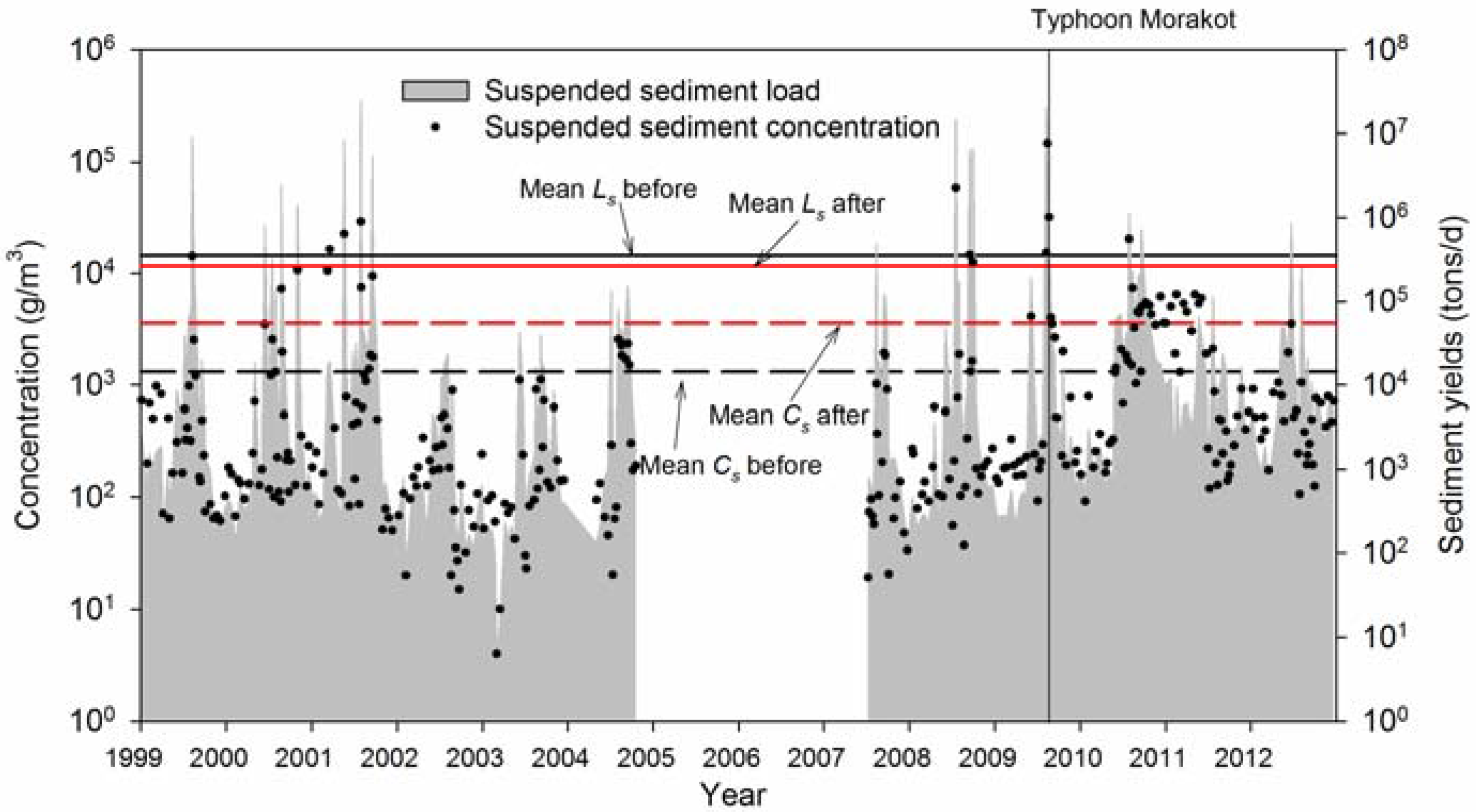
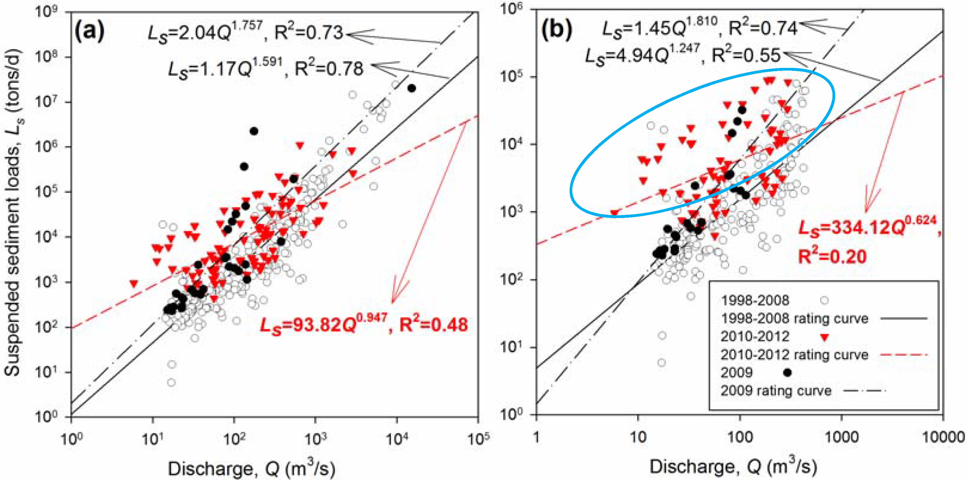
3.1.3. Sediment Rating Curve

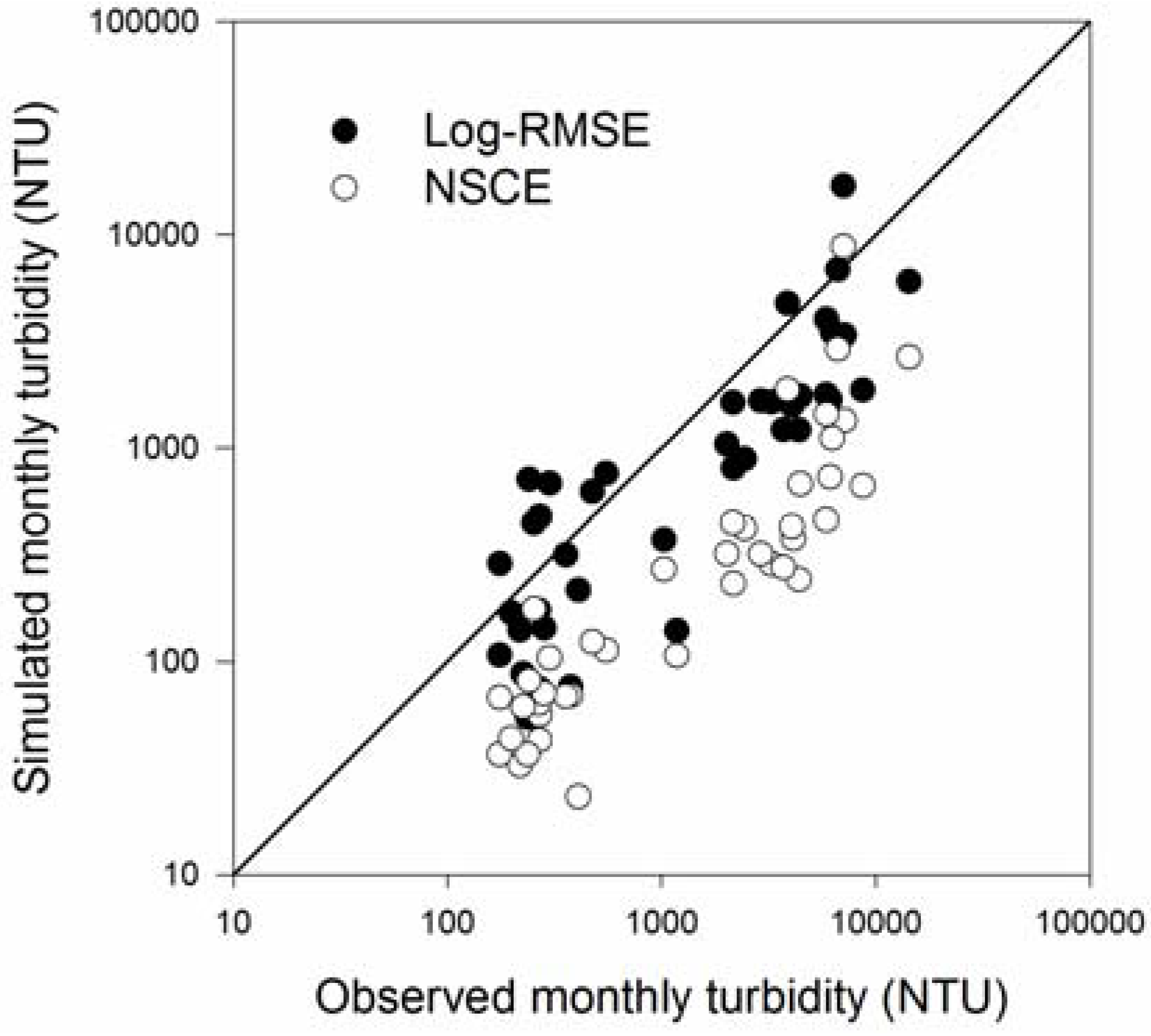
3.2. Simulation of River Flow, Sediment Loads and Turbidity Using SWAT
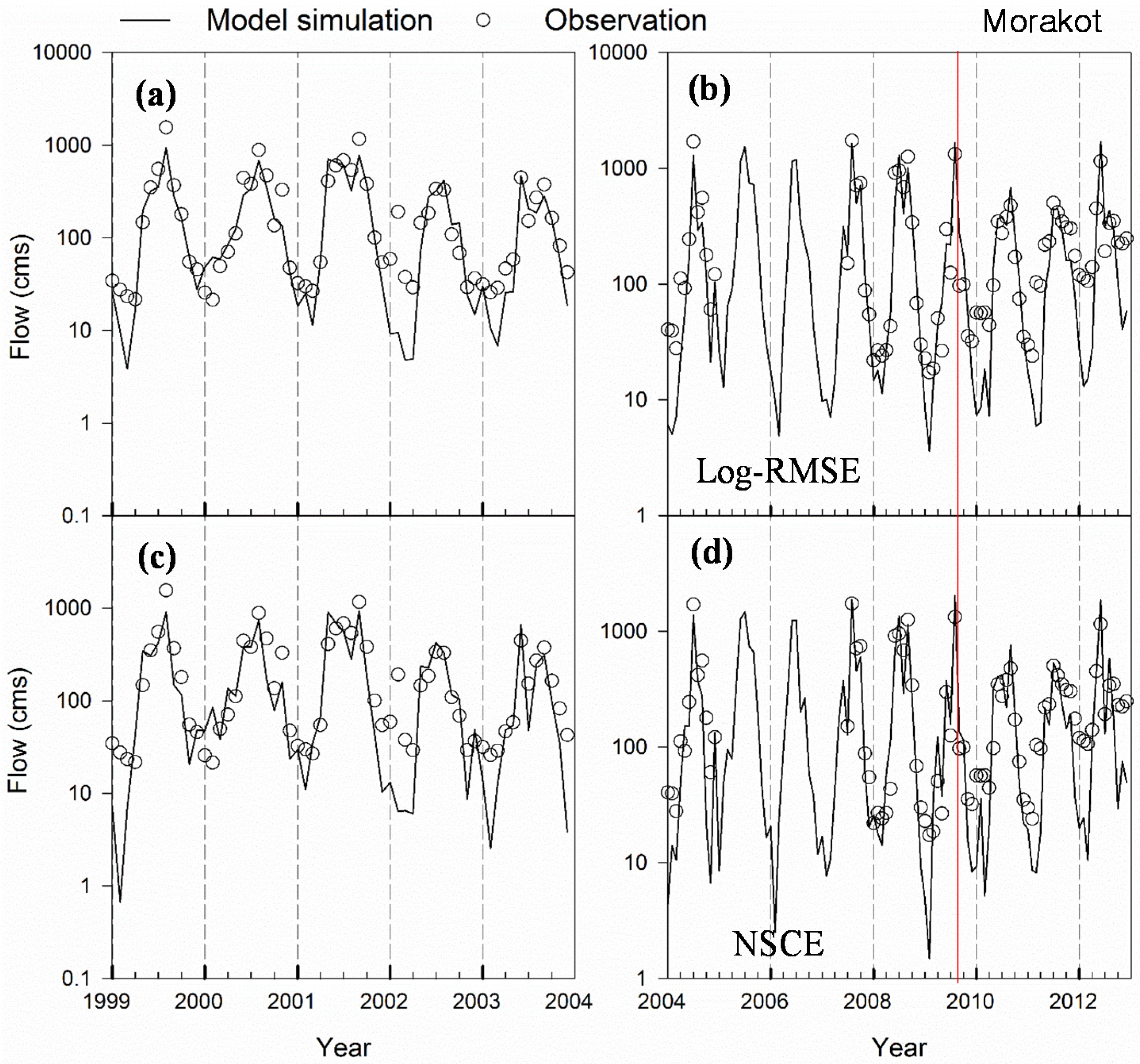
3.2.1. River Flow Simulation

| Time Periods | Simulation of River Discharge with Landslide Updating | Simulation of Suspended Sediment Load with Landslide Updating | ||||||
|---|---|---|---|---|---|---|---|---|
| NSCE Based Calibration | Log-RMSE Based Calibration | NSCE Based Calibration | Log-RMSE Based Calibration | |||||
| NSE | R2 | NSE | R2 | NSE | R2 | NSE | R2 | |
| 1999–2003 (Calibration) | 0.752 | 0.768 | 0.814 | 0.858 | 0.888 | 0.898 | −16.614 | 0.903 |
| 2004–2008 (Pre-Morakot validation) | 0.897 | 0.913 | 0.897 | 0.920 | 0.669 | 0.688 | −10.839 | 0.751 |
| 2009–2012 (Post-Morakot validation) | 0.503 | 0.901 | 0.734 | 0.901 | 0.937 | 0.993 | −0.862 | 0.976 |
| 2004–2012 (overall validation) | 0.789 | 0.852 | 0.855 | 0.873 | 0.884 | 0.909 | −2.831 | 0.845 |
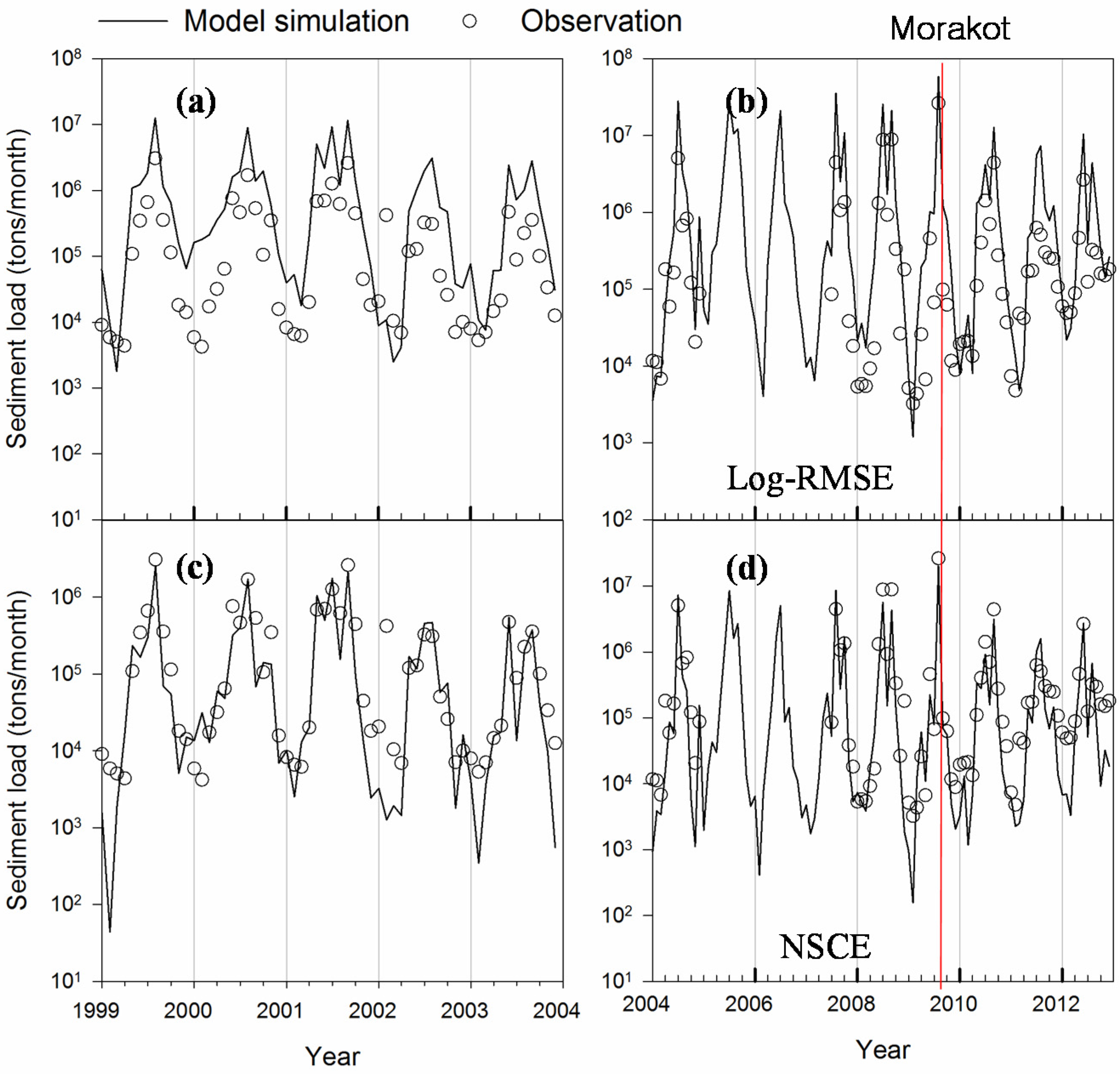
3.2.2. Sediment Load Simulation

3.2.3. Turbidity Simulation
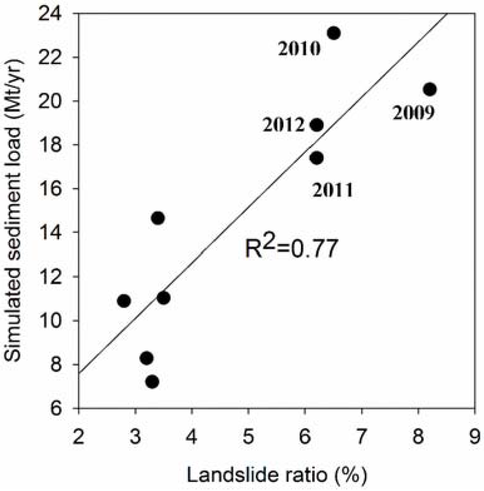
3.3. Modeling the Effects of Landslides on Annual Sediment Yields
3.3.1. Comparison between SWAT Modeling Results with and without the Use of Landslide Updating
| Year | Landslide Ratio (%) | Observed Ls (Mt/yr) | NSCE Simulated Ls (Mt/yr) | Log-RMSE Simulated Ls (Mt/yr) | The Effect of LU Updating on Ls (%) | Difference in Landslide Ratio * (%) | ||
|---|---|---|---|---|---|---|---|---|
| January–July | August–December | Without Updating | With Updating | With Updating | ||||
| 2004 | 2.5 | 3.2 | 7.23 | 8.47 | 8.28 | 35.2 | −2.3 | −0.1 |
| 2005 | 3.2 | 3.4 | - | 14.66 | 14.65 | 62.3 | −0.1 | +0.1 |
| 2006 | 3.4 | 3.3 | - | 7.18 | 7.20 | 30.7 | +0.2 | 0 |
| 2007 | 3.3 | 3.5 | - | 10.94 | 11.03 | 50.0 | +0.8 | +0.2 |
| 2008 | 3.5 | 3.0 | 20.54 | 10.88 | 10.89 | 52.7 | +0.1 | −0.5 |
| 2009 | 3.0 | 8.2 | 27.01 | 17.46 | 20.53 | 63.1 | +17.6 | +4.9 |
| 2010 | 8.2 | 6.5 | 7.53 | 4.40 | 4.99 | 23.1 | +13.4 | +3.2 |
| 2011 | 6.5 | 6.2 | 2.50 | 2.91 | 3.22 | 17.4 | +10.7 | +2.9 |
| 2012 | 6.2 | 4.60 | 3.61 | 3.98 | 18.9 | +10.2 | +2.9 | |
3.3.2. Integration of Landslide Updating and SWAT Modeling
4. Conclusions and Summary
Acknowledgments
Author Contributions
Conflicts of Interest
References
- Chai, B.H.T. Structure and tectonic evolution of Taiwan. Am. J. Sci. 1972, 272, 389–422. [Google Scholar] [CrossRef]
- Li, Y.H. Denudation of Taiwan Island since Pliocene Epoch. Geology 1976, 4, 105–108. [Google Scholar] [CrossRef]
- Kao, S.J.; Milliman, J.D. Water and sediment discharge from small mountainous rivers, Taiwan: The roles of lithology, episodic events, and human activities. J. Geol. 2008, 116, 431–448. [Google Scholar] [CrossRef]
- Hsu, S.M.; Wen, H.Y.; Chen, N.C.; Hsu, S.Y.; Chi, S.Y. Using an integrated method to estimate watershed sediment yield during heavy rain period: A case study in Hualien County, Taiwan. Nat. Hazards Earth Syst. Sci. 2012, 12, 1949–1960. [Google Scholar] [CrossRef]
- Hovius, N.; Stark, C.P.; Chu, H.T.; Lin, J.C. Supply and removal of sediment in a landslide-dominated mountain belt: Central Range, Taiwan. J. Geol. 2000, 108, 73–89. [Google Scholar] [CrossRef] [PubMed]
- Kao, S.J.; Chan, S.C.; Kuo, C.H.; Liu, K.K. Transport-dominated sediment loading in Taiwanese rivers: A case study from the Ma-an Stream. J. Geol. 2005, 113, 217–225. [Google Scholar] [CrossRef]
- Dadson, S.J.; Hovius, N.; Chen, H.G.; Dade, W.B.; Hsieh, M.L.; Willett, S.D.; Hu, J.C.; Horng, M.J.; Chen, M.C.; Stark, C.P.; et al. Links between erosion, runoff variability and seismicity in the Taiwan orogen. Nature 2003, 426, 648–651. [Google Scholar] [CrossRef] [PubMed]
- Lin, G.-W.; Chen, H.; Petley, D.N.; Horng, M.-J.; Wu, S.-J.; Chuang, B. Impact of rainstorm-triggered landslides on high turbidity in a mountain reservoir. Eng. Geol. 2011, 117, 97–103. [Google Scholar] [CrossRef]
- Harris, P.T.; Hughes, M.G.; Baker, E.K.; Dalrymple, R.W.; Keene, J.B. Sediment transport in distributary channels and its export to the pro-deltaic environment in a tidally dominated delta: Fly River, Papua New Guinea. Cont. Shelf Res. 2004, 24, 2431–2454. [Google Scholar] [CrossRef]
- Wass, P.D.; Marks, S.D.; Finch, J.W.; Leeks, G.J.L.; Ingram, J.K. Monitoring and preliminary interpretation of in-river turbidity and remote sensed imagery for suspended sediment transport studies in the Humber catchment. Sci. Total Environ. 1997, 194, 263–283. [Google Scholar] [CrossRef]
- Chuang, S.C.; Chen, H.; Lin, G.-W.; Lin, C.W.; Chang, C.P. Increase in basin sediment yield from landslides in storms following major seismic disturbance. Eng. Geol. 2009, 103, 59–65. [Google Scholar] [CrossRef]
- Aksoy, H.; Kavvas, M.L. A review of hillslope and watershed scale erosion and sediment transport models. Catena 2005, 64, 247–271. [Google Scholar] [CrossRef]
- Pratt, B.; Chang, H.J. Effects of land cover, topography, and built structure on seasonal water quality at multiple spatial scales. J. Hazard. Mater. 2012, 209, 48–58. [Google Scholar] [CrossRef] [PubMed]
- Bathurst, J.C.; Moretti, G.; El-Hames, A.; Moaven-Hashemi, A.; Burton, A. Scenario modelling of basin-scale, shallow landslide sediment yield, Valsassina, Italian Southern Alps. Nat. Hazards Earth Syst. Sci. 2005, 5, 189–202. [Google Scholar] [CrossRef]
- Czaplewski, R.L. Multistage remote sensing—Toward an annual national inventory. J. For. 1999, 97, 44–48. [Google Scholar]
- Liu, C.-C.; Shieh, C.-L.; Lin, J.-C.; Wu, A.-M. Classification of non-vegetated areas using Formosat-2 high spatiotemporal imagery: The case of Tseng-Wen Reservoir catchment area (Taiwan). Int. J. Remote Sens. 2011, 32, 8519–8540. [Google Scholar] [CrossRef]
- Lin, G.-W.; Chen, H. Recurrence of hyper-concentration flows on the orogenic, subtropical island of Taiwan. J. Hydrol. 2013, 502, 139–144. [Google Scholar] [CrossRef]
- Dadson, S.; Hovius, N.; Pegg, S.; Dade, W.B.; Horng, M.J.; Chen, H. Hyperpycnal river flows from an active mountain belt. J. Geophys. Res. Atmos. 2005, 110. [Google Scholar] [CrossRef]
- Hu, C.Y.; Lo, S.L.; Chang, C.L.; Chen, F.L.; Wu, Y.D.; Ma, J.L. Treatment of highly turbid water using chitosan and aluminum salts. Sep. Purif. Technol. 2013, 104, 322–326. [Google Scholar] [CrossRef]
- Kobiyama, M.; Mota, A.D.A.; Grison, F.; Giglio, J.N. Landslide influence on turbidity and total solids in Cubato do Norte River, Santa Catarina, Brazil. Nat. Hazards 2011, 59, 1077–1086. [Google Scholar] [CrossRef]
- Huang, M.Y.F.; Montgomery, D.R. Altered regional sediment transport regime after a large typhoon, southern Taiwan. Geology 2013, 41, 1223–1226. [Google Scholar] [CrossRef]
- Nash, J.E.; Sutcliffe, J.V. River flow forecasting through conceptual models part I—A discussion of principles. J. Hydrol. 1970, 10, 282–290. [Google Scholar] [CrossRef]
- Chung, H.W.; Liu, C.C.; Chiu, Y.S.; Liu, J.T. Spatiotemporal variation of Gaoping River plume observed by Formosat-2 high resolution imagery. J. Mar. Syst. 2014, 132, 28–37. [Google Scholar] [CrossRef]
- Chen, C.Y.; Chen, L.K.; Yu, F.C.; Lin, S.C.; Lin, Y.C.; Lee, C.L.; Wang, Y.T. Landslides affecting sedimentary characteristics of reservoir basin. Environ. Earth Sci. 2010, 59, 1693–1702. [Google Scholar] [CrossRef]
- Dadson, S.J.; Hovius, N.; Chen, H.; Dade, W.B.; Lin, J.C.; Hsu, M.L.; Lin, C.W.; Horng, M.J.; Chen, T.C.; Milliman, J.; et al. Earthquake-triggered increase in sediment delivery from an active mountain belt. Geology 2004, 32, 733–736. [Google Scholar] [CrossRef]
- Taiwan Forestry Bureau (TWFB). Applying Satelliet Images in Taiwan Landslide Interpretation and Disaster Damage Analysis Project; Forest Bureau, Council of Agriculture Executive Yuan: Taipei, Taiwan, 2012. (in Chinese) [Google Scholar]
- Stark, C.P.; Barbour, J.R.; Hayakawa, Y.S.; Hattanji, T.; Hovius, N.; Chen, H.G.; Lin, C.W.; Horng, M.J.; Xu, K.Q.; Fukahata, Y. The climatic signature of incised river meanders. Science 2010, 327, 1497–1501. [Google Scholar] [CrossRef] [PubMed]
- Comber, A.; Fisher, P.; Wadsworth, R. What is land cover? Environ. Plan. B 2005, 32, 199–209. [Google Scholar] [CrossRef]
- Introduction to NLSC Affairs: National Land Surveying and Mapping Program. Available online: http://www.nlsc.gov.tw/En/MakePage/166?level=166 (accessed on 28 August 2015).
- Neitsch, S.L.; Arnold, J.G.; Kiniry, J.R.; Williams, J.R. Soil and Water Assessment Tool Theoretical Documentation Version 2009; Texas Water Resources Institute: College Station, TX, USA, 2011. [Google Scholar]
- Williams, J.R.; Berndt, H.D. Sediment yield prediction based on watershed hydrology. Trans. ASAE 1977, 20, 1100–1104. [Google Scholar] [CrossRef]
- Van Griensven, A.; Bauwens, W. Multiobjective autocalibration for semidistributed water quality models. Water Resour. Res. 2003, 39. [Google Scholar] [CrossRef]
- Van Griensven, A.; Meixner, T.; Grunwald, S.; Bishop, T.; Diluzio, A.; Srinivasan, R. A global sensitivity analysis tool for the parameters of multi-variable catchment models. J. Hydrol. 2006, 324, 10–23. [Google Scholar] [CrossRef]
- Du, J.K.; Rui, H.Y.; Zuo, T.H.; Li, Q.; Zheng, D.P.; Chen, A.L.; Xu, Y.P.; Xu, C.Y. Hydrological simulation by SWAT model with fixed and varied parameterization approaches under land use change. Water Resour. Manag. 2013, 27, 2823–2838. [Google Scholar] [CrossRef]
- Efstratiadis, A.; Koutsoyiannis, D. One decade of multi-objective calibration approaches in hydrological modelling: A review. Hydrol. Sci. J. 2010, 55, 58–78. [Google Scholar] [CrossRef]
- Bekele, E.G.; Nicklow, J.W. Multi-objective automatic calibration of SWAT using NSGA-II. J. Hydrol. 2007, 341, 165–176. [Google Scholar] [CrossRef]
- Arnold, J.G.; Williams, J.R.; Maidment, D.R. Continuous-time water and sediment routing model for large basins. J. Hydraul. Eng. ASCE 1995, 121, 171–183. [Google Scholar] [CrossRef]
- Wang, F.; Mu, X.; Hessel, R.; Zhang, W.; Ritsema, C.J.; Li, R. Runoff and Sediment load of the Yan River, China: Changes over the last 60 yr. Hydrol. Earth Syst. Sci. 2013, 17, 2515–2527. [Google Scholar] [CrossRef]
© 2015 by the authors; licensee MDPI, Basel, Switzerland. This article is an open access article distributed under the terms and conditions of the Creative Commons by Attribution (CC-BY) license (http://creativecommons.org/licenses/by/4.0/).
Share and Cite
Chang, C.; Harrison, J.F.; Huang, Y. Modeling Typhoon‐Induced Alterations on River Sediment Transport and Turbidity Based on Dynamic Landslide Inventories: Gaoping River Basin, Taiwan. Water 2015, 7, 6910-6930. https://doi.org/10.3390/w7126666
Chang C, Harrison JF, Huang Y. Modeling Typhoon‐Induced Alterations on River Sediment Transport and Turbidity Based on Dynamic Landslide Inventories: Gaoping River Basin, Taiwan. Water. 2015; 7(12):6910-6930. https://doi.org/10.3390/w7126666
Chicago/Turabian StyleChang, Chih‐Hua, John F. Harrison, and Yu‐Chi Huang. 2015. "Modeling Typhoon‐Induced Alterations on River Sediment Transport and Turbidity Based on Dynamic Landslide Inventories: Gaoping River Basin, Taiwan" Water 7, no. 12: 6910-6930. https://doi.org/10.3390/w7126666
APA StyleChang, C., Harrison, J. F., & Huang, Y. (2015). Modeling Typhoon‐Induced Alterations on River Sediment Transport and Turbidity Based on Dynamic Landslide Inventories: Gaoping River Basin, Taiwan. Water, 7(12), 6910-6930. https://doi.org/10.3390/w7126666