Article

Smart Technological Urban Flood Management Strategies Are “Must-Do” Approaches: The Case of Chinese Coastal Megacity, Ningbo, East Coast of China


1
School of Geographical Sciences, Faculty of Science and Engineering, University of Nottingham Ningbo China, Ningbo 315100, China
2
School of Geography, University of Leeds, Leeds LS2 9JT, UK
3
Ningbo Water Conservancy & Hydropower Planning and Design Institute Co., Ltd., Ningbo 315100, China
4
Key Laboratory of Urban Environment and Health, Institute of Urban Environment, Chinese Academy of Sciences, Xiamen 361021, China
5
School of Mathematical Sciences, Faculty of Science and Engineering, University of Nottingham Ningbo China, Ningbo 315100, China
*
Authors to whom correspondence should be addressed.
Water 2026, 18(3), 427; https://doi.org/10.3390/w18030427
Submission received: 14 December 2025 / Revised: 14 January 2026 / Accepted: 20 January 2026 / Published: 6 February 2026

Abstract

Ningbo (NGB), a major port city on China’s east coast, is defined by a network of over 100 rivers across three major catchments. From the 1970s to the 2000s, extensive engineering, including channelisation and embankment construction, was used to manage flood risk during rapid urbanisation. Since the 2010s, however, the city has shifted towards smart flood management. The Ningbo government and Water Bureau have deployed digital twins and technologies like 3D flood mapping and real-time monitoring, significantly improving precision. Our study demonstrated that this smart technology performed effectively during recent extreme events, namely typhoons In-Fa (2021) and Muifa (2022), helping the Municipal Bureau to safeguard public safety. This success strengthens municipal and national commitments to climate resilience. Nevertheless, further advancement of the digital twin platform is required. Key priorities include boosting computational capacity, improving cross-departmental coordination, establishing open data sharing, and integrating artificial intelligence (AI) to enhance decision-making during future climate extremes.

1. Introduction

1.1. Increasing Flood Hazards

China is the country that has been the global champion of urbanisation, with an average urbanisation rate of over 64% [1]. China’s rapid urban growth has resulted in dense, disorderly cities. This sprawl has degraded urban ecosystems and harmed residents’ physical and mental health [2] and their social well-being. Chinese coastal provinces like Zhejiang, Fujian, and Guangdong are the frontlines of climate risk. Their exposure to frequent typhoons, combined with rapid urbanisation across flat, low-lying land, creates a severe and growing threat of flooding [3].
In response to these challenges, the Central National Government (CNG) launched the “Sponge City Programme” (SCP) in 2013 [4,5]. The SCP is a policy instrument, conceptually similar to Nature-based Solutions (NBSs) [6], yet it is operationalised within China’s specific planning and jurisdictional systems and it is designed to advance the national goals of “ecological civilisation” and green urban development.
The SCP addresses substantial urban stormwater problems like surface flooding and pollution by prioritising the implementation of blue-green infrastructure (BGI) over reliance on conventional “grey” drainage systems [7]. The SCP moves beyond traditional greenery (e.g., parks, forests) to deliver multiple benefits by integrating “blue” elements (e.g., ponds, wetlands) and “green” infrastructure (e.g., swales, rain gardens) with bioretention functions [8]. Ultimately, this infrastructure serves multiple purposes: it purifies and mitigates stormwater pollution and provides resilient water storage to help cities cope with both floods and droughts throughout the year in both wet and dry seasons [9].
Over the last decade, the SCP has progressively retrofitted 30 pilot cities with blue-green infrastructure. This integration is designed to enhance urban liveability, resilience, and sustainability, and is applicable in the retrofitting of old towns and the planning of novel developments. There is widespread use of bioretention infrastructure in Sponge Cities in Cicheng, an old district of Ningbo. Here, an artificial wetland park treats residential stormwater by removing pollutants like suspended solids, nitrogen, and phosphorus [10].
For example, the urban park design in the SCP is equipped with its extensive reedbeds and native vegetation. That provides substantial stormwater storage while also serving as a recreational space with trails and functioning as a playground. This purpose exemplifies how bioretention infrastructure in new developments can improve stormwater management by reducing runoff and peak discharge while also enhancing the urban hydrological cycle, fostering public engagement [11,12].
Despite the SCP’s adoption, the increasing frequency of extreme climate events presents a major challenge. Climate change projections indicate, for example, that rising sea temperatures in the West Pacific will likely intensify future tropical cyclones, testing the programme’s resilience [2]. This will impact the deltaic region of the Yangtze River and the Pearl River, two of the most important economic centres and logistic hubs in southeast China, where many major cities like Ningbo, Shanghai, Hong Kong, Shenzhen, and Guangzhou are located, which will be significant [13]. This trend is evidenced by data from the Hong Kong Observatory, which recorded over 40 typhoons in the Pearl River Delta region in recent decades [14]. The agency further projected that typhoons, storm surges, and intense rainstorms will become more frequent in the coming years. As a result, we witnessed the compound urban flood consequences that occurred in Ningbo during 2022 and 2021 after typhoons Muifa and In-Fa [15].

1.2. The Importance of Smart Technological Approaches

The probability of urban surface flooding in southeastern China’s coastal cities is rising due to a confluence of factors: more frequent, intense rainstorms that overwhelm drainage systems; seawater backlash and direct inundation from storm surges; and the compounding effects of these events [16]. This risk is amplified by long-term sea-level rise. Global projections estimate a rise of 0.2–0.4 m in the next 50 years, potentially reaching 1.2–1.8 m by 2100 [17]. Locally, the Hong Kong Observatory and China’s State Ocean Bureau have recorded an annual rise of 2.1–2.3 mm since the 1950s [18], a trend consistent with projections from Shanghai authorities [19]. Together, these intensifying hydrological pressures and rising seas present a formidable dual challenge to urban flood governance [20].
To address these escalating climate risks, the Ningbo Water Bureau is leveraging advanced technology. It is implementing a “digital twin” and large-data numerical modelling, and potentially artificial intelligence systems to simulate complex hydrological scenarios more effectively, such as by providing more accurate scenario analyses, helping stakeholders to enhance predictive capabilities, optimising real-time responses to storm surges and extreme rainfall, and directly informing and adapting the city’s Sponge City infrastructure.
This paper investigates the role of smart water management technologies (e.g., digital twins) in enhancing urban resilience, using Ningbo’s response to typhoons such as typhoons “In-Fa” (2021) and “Muifa” (2022) as examples. We illustrate how these digital twin and technologically driven strategies minimise the impacts of floods and climate risk (e.g., injury and damage). This study provides transferable lessons for flood governance in other vulnerable coastal cities. The study was guided by three specific objectives:
  • To assess how smart technologies have improved climate-resilient practice in Ningbo.
  • To analyse the role and implications of smart technologies in enhancing climate resilience.
  • To identify the current challenges and propose recommendations for strengthening future climate-resilience practice.

2. Methods
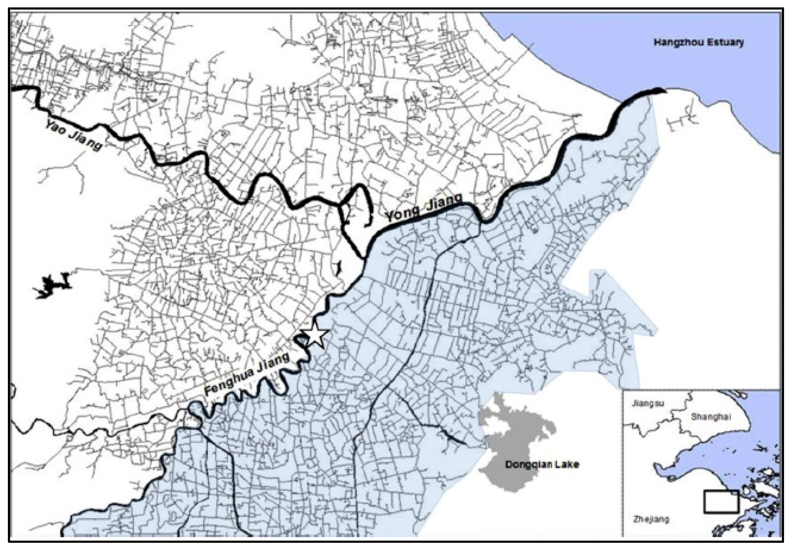
The study area, Ningbo, is a coastal city on China’s east coast with a land area of 9816 km2 (Figure 1). Its hydrology is defined by pronounced seasonality, with approximately 750 mm of its 1500 mm mean annual rainfall concentrated in the June–October typhoon season, compared to 250–300 mm in the November–February dry season. Water resources management thus prioritises both flood prevention through reservoir infrastructure and dry-season provisioning [21]. Geographically, the majority of the city lies on flat land (2–10 m above sea level), within a tidal range of 1.6–5.8 m. Ningbo’s traditional land drainage system is designed for relatively frequent rainfall events, with a capacity for storms with a 1- to 5-year return period. This leaves the city highly vulnerable during typhoons, as intense stormwater cannot be discharged quickly. The problem is exacerbated by the three tidal rivers (Yao, Fenghua, and Yong), where concurrent storm surges elevate water levels, drastically reducing the system’s runoff capacity. Typhoons have inflicted severe costs on Ningbo, with 50 events and CNY 93 billion in losses since the 1950s [22].
Facing ongoing risks from surges and tides, the city joined the Sponge City Programme (SCP) in 2015 [23]. This commitment aims to upgrade stormwater protection to a 1-in-30-year standard and transform 80% of the urban area with retrofitted drainage and integrated green–blue infrastructure by 2030 [24].
Ningbo’s subtropical monsoon climate brings highly concentrated rainfall, with 65.6% of the 1457 mm annual total falling between May and September. This pattern, compounded by typhoons, creates a high risk of concurrent flooding, waterlogging, and tidal inundation—the so-called “triple impact.” Analysis of 35 years of rainfall data (1981–2015) showed that to achieve an 80% annual runoff control rate in Ningbo requires infrastructure designed for a 24.7 mm rainfall event.
Figure 1. Location of Ningbo City, Zhejiang Province, southeast China (shaded area indicates modelled drainage network and indicates location of rainfall and canal-level gauge data) (Source: approved to use by Griffiths, Chan [25]).
Water 18 00427 g001
However, typhoons frequently exceed this capacity. For instance, in September 2022, typhoon Muifa delivered over 292.6 mm in 24 h at Cicheng, reaching a 1-in-100-year event that far surpasses the SCP’s 1-in-30-year design standard [26] (see Figure 2). That said, the SCP infrastructure can be overwhelmed during such extreme events.
The study area is characterised by a complex floodplain water network, featuring coastal waters, rivers, low-lying terrain, and dense river systems. Among the 56 distinct water systems, low flow velocity and poor self-purification capacity are common. Furthermore, the predominant silty clay soil exhibits poor permeability, with a coefficient ranging from 1.2 to 2 × 10⁻⁷ cm/s, which limits natural infiltration.
Cicheng, located in the Jiangbei district, exemplifies these challenges within an ageing urban fabric. The ancient town area has a high density, contains key cultural relics, and suffers from a low greening rate, poor water quality, and prominent combined sewer overflow (CSO) pollution, leading to frequent waterlogging [27].
In contrast, the new town area was planned with “water-sensitive” concepts, but suffered from long-term operational neglect of its existing facilities. Consequently, SCP interventions in Cicheng were tailored to these distinct contexts. In the ancient town, the focus was on mitigating the combined urban issues of waterlogging and CSO pollution. In the new town, the strategy centred on upgrading and repairing neglected SCP infrastructure while enforcing stricter planning controls on new developments [28].

2.1. Research Design—Qualitative Approach

This study focused on three connected SCP sites in Ningbo, where the recently built NBSs of urban stormwater designs aim to improve urban flood resilience and water quality and expand green and blue–green spaces.
The research methodology is qualitative, combining two primary data collection strategies: document analysis of relevant policies and semi-structured interviews (SSIs) with key stakeholders. Semi-structured interviews were chosen from the continuum of interview types (structured, semi-structured, unstructured) as they provide a flexible yet focused framework for exploring complex experiences and governance processes in depth.
Public perception and participation were assessed using structured interviews, characterised by a planned and rigorous set of identical questions for all participants [29,30]. This method was deployed in three Ningbo NBS case studies, situated in varied contexts. By comparing perceptions across different sites, we identified the patterns and variances that illuminate the current state of local community engagement in China’s SCP, as well as the underlying motivations for participation within the context of differing hydrogeographical and urban conditions, using the case of Ningbo.

2.1.1. Semi-Structured Interviews (SSIs)

Semi-structured interviews (SSIs) were conducted conversationally, allowing participants to elaborate on issues they deemed significant. This method is well-suited for exploring complex governance challenges; for instance, the SSI method is well-adopted by communities and stakeholders to identify barriers to urban flood and climate adaptation. In our study, this approach enabled an in-depth exploration of stakeholder perspectives of SCP implementation and digital water management strategies [31].
Data collection involved 11 semi-structured interviews, which were conducted from March to August 2025. Each interview lasted approximately 20 to 30 min. In adherence to ethical protocols, this study received approval from the University of Nottingham’s ethics committee. Before participation, all interviewees were briefed on the study’s aims and provided written informed consent. All of the data were anonymised to ensure participant confidentiality (see Table 1).
To ensure privacy, all responses were anonymised and any demographic details provided (e.g., occupation, age) were kept confidential. All of the data were stored securely and destroyed upon project completion, in full accordance with ethical research conduct under the ethics guidance from the university and to protect the privacy of all interviewees.

2.1.2. Data Analyses and Coding

For this study, we selected participants from two key groups to capture diverse perspectives: (1) stakeholders and governmental engineers with direct experience of flooding, particularly in areas like the Haizhu district, and (2) technical experts familiar with flood infrastructure and smart water management systems.
Additionally, to understand institutional and policy dimensions, we conducted interviews with officials from relevant administrative bodies. This included personnel from the Ningbo Water Bureau and the local Sponge City Office (SPO), who provided insights into current flood management strategies and SCP implementation from a governance perspective.
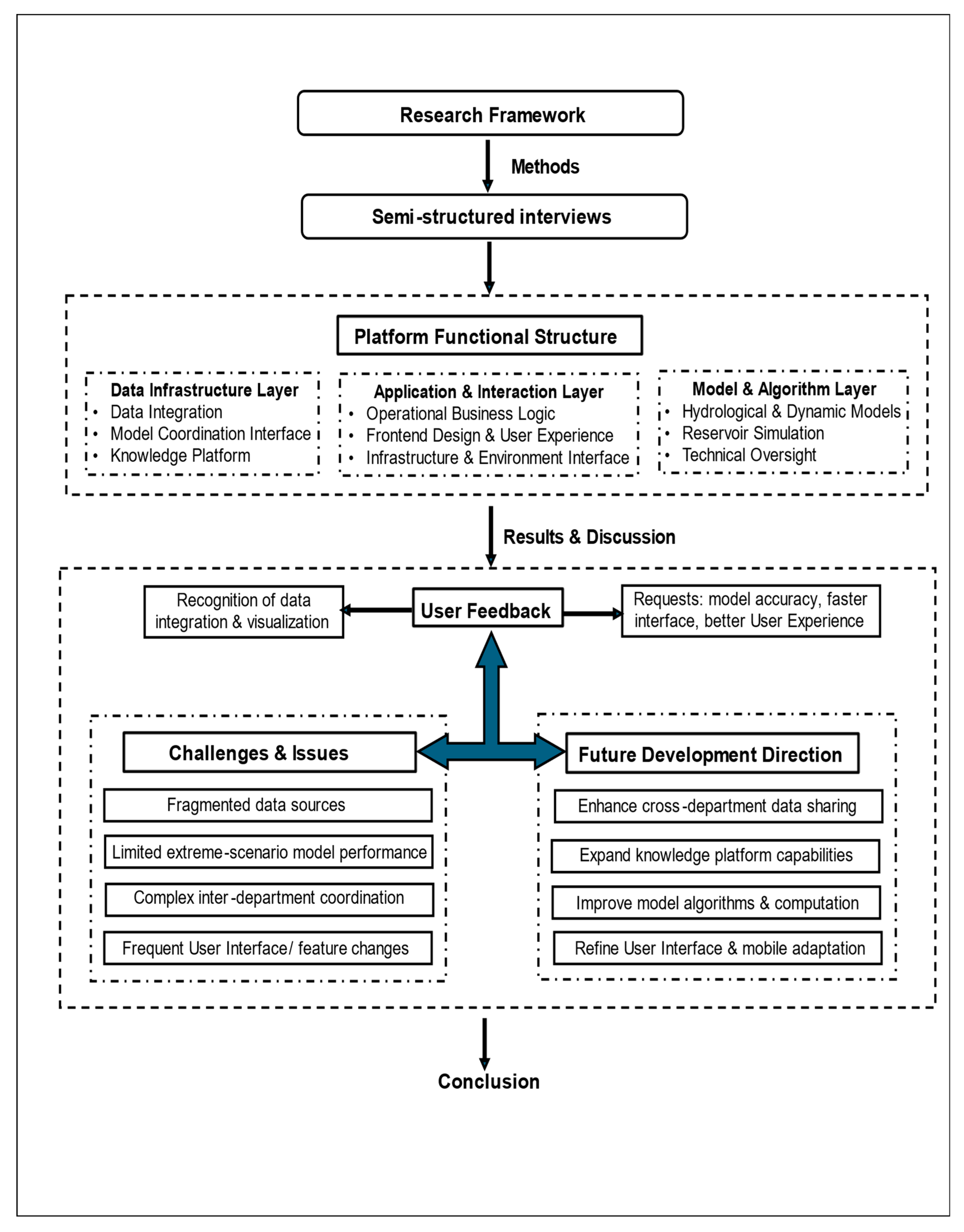
All interview data were transcribed, translated from Chinese to English, and analysed using thematic analysis. This involved iterative coding of the transcripts to identify key themes (see Figure 3). To ensure validity, the findings were triangulated with official government reports and documents (see Results and Discussion, Section 3).

2.2. Digital Twin Platform: Facts and Progress

China has moved forward with a “digital twin” (DT) for water resources management, which was initiated during the 14th Five-Year Plan period from 2021 to 2025 [32]. The Chinese National Government have systematically implemented digital twin systems in catchments according to water conservancy sectors and industries [33]. The country will speed up the development of the DT system to improve flood control and enhance water security. A DT is a data-driven digital representation of water bodies and water resources infrastructure, which can provide a more holistic picture of the real-time accurate changes in water resources, such as the water flow, discharge, and water levels of dams and rivers [34].
In recent years, China’s Ministry of Water Resources has systematically advanced the construction of smart water conservancy, with the concept and practice of a “digital twin” serving as a core driving force [35]. Starting from 2021, the Ministry formally proposed the construction of a “digital twin catchment”, leveraging advanced information technologies such as data, algorithms, and computing power to achieve intelligent simulation and refined decision support, thereby accelerating the establishment of a smart water conservancy system capable of forecasting, warning, simulation, and contingency planning.
This marked the official integration of digital twin technology with smart water conservancy. Building upon this foundation, the Ministry further clarified the overall framework for smart water conservancy in 2022, introducing the concepts of the “digital twin water conservancy project” and the “digital twin water network” and developed a corresponding top-level design. This led to the formation of the “digital twin smart water conservancy series,” which comprises three core components: the digital twin watershed, the digital twin water network, and the digital twin water conservancy project [36].
The three core components correspond to physical watersheds, physical water networks, and physical water conservancy projects, respectively, and are mapped into the digital space [37]. Their interrelationships are defined by the actual connections among these physical entities: the three physical entities are distinct yet interrelated, each with its own focus, relatively independent yet interconnected, and capable of sharing information. This ensures the organic integration of the three components, collectively supporting comprehensive perception, intelligent simulation, precise decision-making, and efficient operation in the field of water conservancy. China’s Ministry of Water Resources further elucidated the overall design and construction goals of the “Digital Twins of Water Resources System” [34].
Following the principles of “demand-driven, application-first, digital empowerment, and capability enhancement”, the initiative focuses on digitalisation, networking and intelligentisation. It aims to build digital twin river basins, conduct intelligent simulations, and support precise decision-making for flood engineers and stakeholders. Efforts are being accelerated to build digital twins of water resources systems with the capabilities for forecasting, early warning, simulation and pre-planning. The “Digital Twins of Water Resources System” was officially proposed in China as a key pathway for improving water resources management [32,36].
The National Water Bureau set priorities to build digital twins across the regional and local river basins and catchments that influence water resources allocation, urban and rural water supply, flood control and drainage, water ecological protection, and smart water networks. The National Government established the Technical Outline for the Development of Digital Twins of River Basins. It established the digital twins of water resources system as a new type of infrastructure that takes physical basins as quantitative units by using spatial–temporal data that combines hydrological models, meteorological information (e.g., rainfall, humidity, wind direction, etc.), and water resources information (river and dam water depth and volume, discharge, etc.) from all of the elements of physical river basins [38,39].
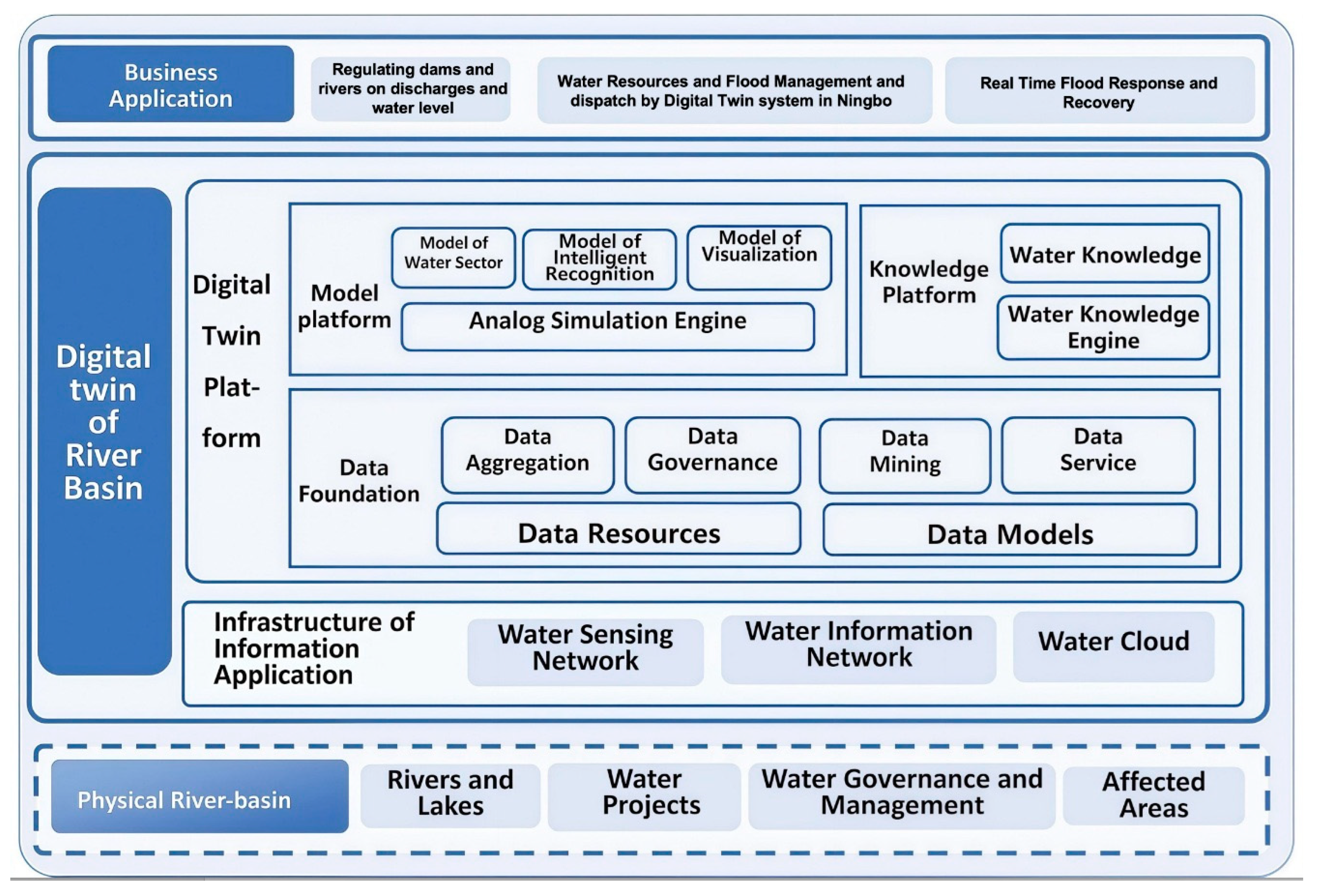
For example, we adopted the DT framework by Peng [34] in the case of Ningbo, which enables intelligent simulations, disaster response operations, and operations in synchronous simulation with physical basins, an empowering interaction between the virtual and the physical that allows iterative optimisation. This allows for real-time monitoring, problem identification, and optimised scheduling of physical river basins (see Figure 4).
The DT platform in Ningbo adopts a four-layer architecture to ensure comprehensive perception and intelligent decision-making. The information infrastructure layer integrates traditional and new water conservancy monitoring networks, which cover hydrology, engineering safety, water quality, and safety monitoring, and relies on water conservancy information networks, government affairs networks, and the Internet of Things for data transmission.
The Twin Data Foundation encompasses geospatial information (DEM, orthophoto, oblique photography), BIM models, underwater topographic data, water conservancy project information, socio-economic data, and historical typhoon or flood databases.
The model platform layer adopts a reusable component-based model framework and an integrated hydrologic–hydrodynamic model system, supplemented by parallel solvers and online model computing services.
The Business Application Layer focuses on the “Four Preparations” (forecasting, early warning, simulation, and planning) for reservoir flood control, with the ability to intelligently answer questions, operate reservoirs based on knowledge management, and provide warnings through the risk early warning module. The comprehensive decision-making level integrates cross-departmental data and supports collaborative decision-making through a shared knowledge base.
The DT platform adopts a component-based generalisation approach, abstracting hydrological and hydrodynamic processes into five core components: hydrological model components, river network model components, 2D model components, coupled model components, and artificial structures.
The key modelling methods include:
(1)
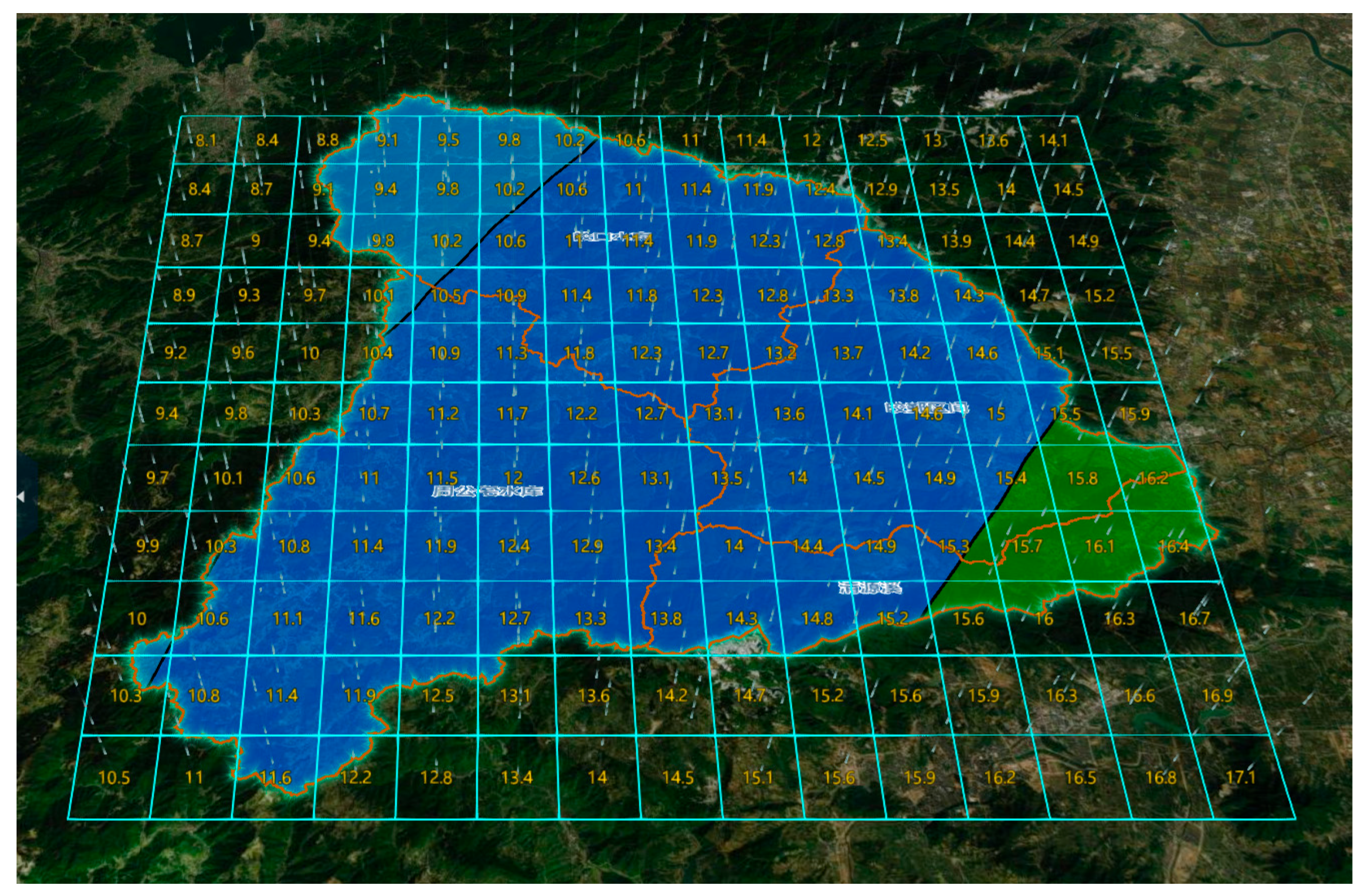
A regional refined rainfall interpretation model, which converts meteorological numerical forecast data (stored in GRIB format) into hourly rainfall processes for sub-watersheds (See Figure 5);
(2)
Runoff and confluence models, including a Xinanjiang model, an initial loss-later loss method, a unit hydrograph, and a linear reservoir;
(3)
A reservoir operation model, which simulates water level and outflow under multi-scenario conditions to support flood control, water supply, and power generation;
(4)
Flood routing models, both 1D and 2D, using finite difference and finite volume methods to find numerical solutions, with a 2D grid division (25 m/50 m precision) covering floodplains;
(5)
Integrated coupled models, including vertical/lateral coupling of hydrological–hydrodynamic models and 1D–2D hydrodynamic models to realise flood interaction between rivers and floodplains.

3. Results and Discussion

In this study, we used a qualitative approach to obtain information via semi-structured interviews (SSIs). We obtained the primary data from the water and flood engineers, governmental officials, and scholars. We interpret the viewpoints from these stakeholders in the DT application and consider its operation in the case study of Ningbo, within the context of individuals with differing expertise and the real experience and challenges of their roles.
Consistencies and divergences in current DT development for water resources management and viewpoints on the challenges and opportunities of DTs are obtained. The results and discussion will illustrate the applications (Section 3.1), such as the functions and real applications of the DT and the implications for the DT platform (Section 3.2), as well as the challenges and future developments.

3.1. Application of the Digital Twin Platform

3.1.1. Data Sources and Application of the DT Platform

The stakeholders, such as governmental water and flood engineers, are the primary users of the DT system. Their viewpoints are essential for understanding current operations, system challenges, and concerns relevant to decision-making in planning and implementation. Through the SSIs, we examined key operational issues in operating the DT platform.
Data source
A central challenge concerns the reliability and accuracy of data input. In fact, of data source accessibility and operation. Data sources include real-time data (water level, discharge, rainfall from sensors, CCTV feeds), historical data (58 flood events during 2012–2023, including 9 typhoon-induced floods), spatial data (DEM, underwater terrain, cross-sectional data of dikes and sluices), and meteorological data (hourly rainfall processes from Ningbo Meteorological Observatory).
The monitoring network covers the Zhougongzhai–Jiaokou cascade reservoirs and their downstream impact areas, with key monitoring points at critical sections (Zhongjiatan, Dajiaocun, Hongshuiwan).
Engineer A stated that, “Large volumes of legacy drawings and reports normally need to be standardised before they can be double checked with the live sensor and CCTV feeds”. This reflects the necessity of validating real-time data (e.g., water levels, discharge patterns) against historical records to ensure accurate situational awareness, especially for protecting communities located adjacent to rivers in the flood-prone areas during the typhoon and rainstorm seasons (normally in the summer for Ningbo).
Visualisation and Intelligence
This reflects the workflow platform of the connection between visualisation and intelligent recognition in the water sector in general, or in a specific case. Another engineer also shared details of more technical operational patterns that we might not be aware of. Engineer D shared his experience on handling data information, “… I can confirm we have seriously handled all data sources carefully, for example, we assess to check the flood risk mapping on the water level of reservoirs, riverbanks and all monitoring sites with the videos and real-time water-level indications coherently.”
Knowledge Graphs and Mappings
The Ningbo case focuses on the coupled Zhougongzhai and Jiaokou reservoir system and their downstream influence zones. The digital twin model was constructed over the two reservoirs, their impoundment areas, and the affected downstream reaches. The input datasets included historical hydrology (precipitation, evaporation), reservoir levels, and operational logs; spatial data such as high-resolution DEM and bathymetry; and hydraulic infrastructure data (reservoir parameters, spillway capacities, river cross-sections, and levee characteristics).
Using these data, the watershed was divided into four production-runoff sub-basins, based on a digital elevation model (DEM) and land-cover features. Each sub-basin is connected via the model topology to the reservoir components and downstream river channels. The model network was assembled by linking these components in topological order and setting upstream boundaries at hierarchy level 0, with Zhougongzhai at level 2 and Jiaokou at level 3 (See Figure 6).
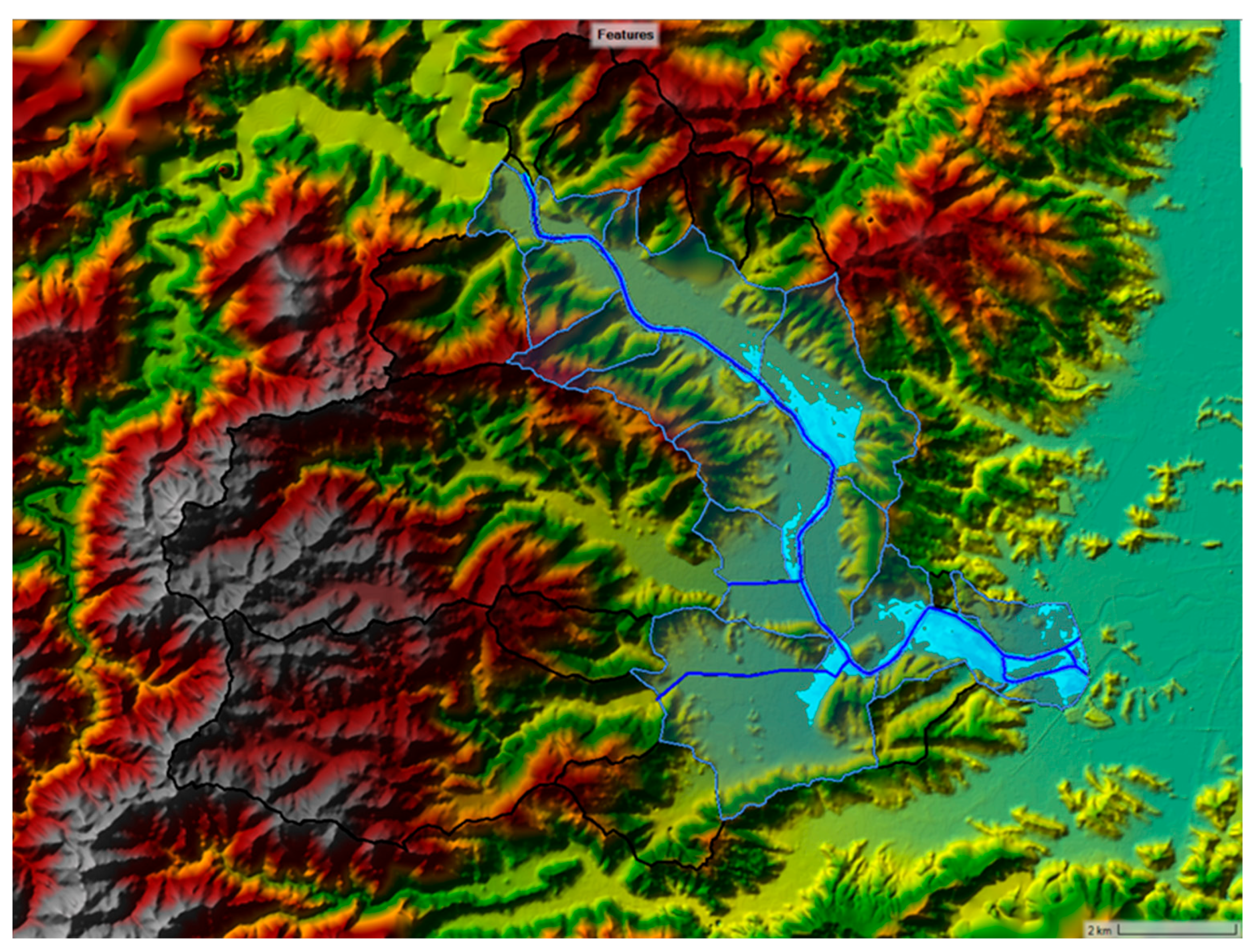
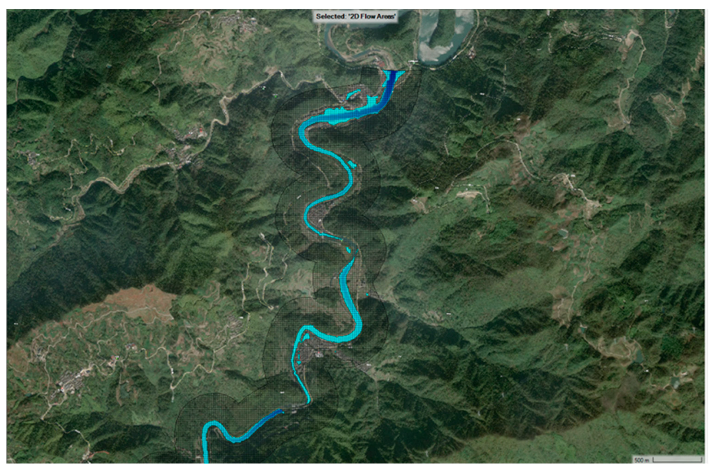
A high-resolution 2D floodplain mesh was generated as well: for the main Zhougong–Jiaokou reach, the floodplain extends ~300 m beyond the river centreline with 25 m grid cells (6103 cells total), while in the Jiaokou–downstream reach, the inundation zone uses 50 m cells (16,346 cells) to capture floodplain risk areas. The 1D river model contains the detailed channel network (see Figure 7).
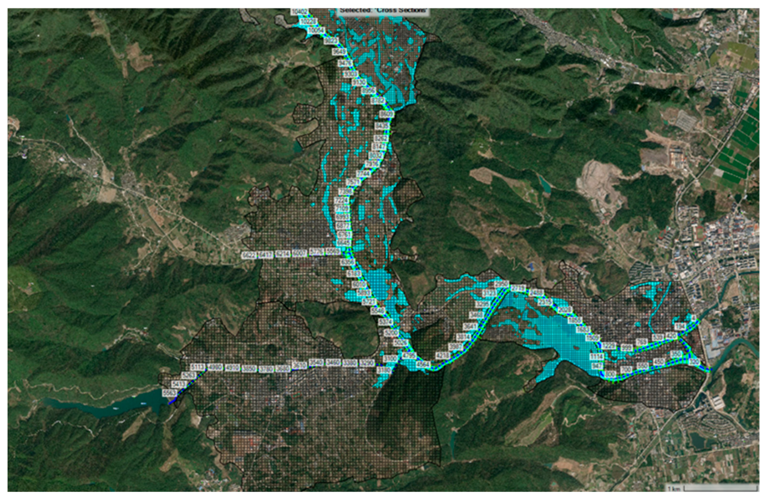
For example, the Zhougong–Jiaokou segment has 1 river reach, 112 cross-sections, and 2 storage zones; the Jiaokou downstream segment has 10 reaches, 420 cross-sections, and 19 storage zones. These 1D and 2D components were then coupled, enabling flood waves to transfer between rivers and the floodplain (see Figure 8).
Another engineer, H, echoed Engineer D to further illustrate the connection of the model platform with the knowledge platform in the DT system and stated that the key operation and connection of the hydrological model with the knowledge model is through use of the knowledge graphs, as detailed here: “…We have optimised the connection in the DT system between the hydrological model with the knowledge platform by using the knowledge graphs (KGs) to connect dispersed information and resources.” That process strengthens real-time interpretation of hydrological conditions, such as water discharge, water level, and projected flood dynamics under rainstorms and typhoons.
For example, the knowledge graph can support engineers to extract more precise information for flood forecasting and site locations with projected scenarios, such as showing if the water level exceeds the mean water level (i.e., exceeds 1–2 m) and the effects on the surrounding areas (e.g., potential flood impacts to roads and properties).

3.1.2. Challenges and Limitations of the DT Operation

The DT system has substantially enhanced the effectiveness and efficiency of flood and water resources management in Ningbo. Nevertheless, engineers identified several operational limitations that constrain its performance.
Imperfect model performance
Model accuracy can decline under extreme scenarios, for example, during typhoon conditions (e.g., typhoon Muifa in 2022). Engineer E explained that “We normally need to recalibrate some parameters due to the water discharge and sediment fluxes during the fast flow period in storms.” Such recalibration requires immediate intervention from engineers. Engineer E further noted the importance of routine maintenance and check-ups for the calibration of parameters: “With regular updates and check-ups, we can get hold of the accuracy of results.”
Topographical and Physical Constraints
Terrain characteristics also pose challenges in ensuring the accuracy and reliability of the system, one individual noted, “… In the mountainous regions, such as Siming Mountain in Ningbo, the basins with steep longitudinal hillslopes, geo-spatial settings and timing issues are especially sensitive.” These physical constraints complicate numerical modelling and simulation difficulties, particularly in areas with steep and complex topography.
Climatic extreme conditions
Storms and typhoon events diminish real-time model reliability. Engineer J mentioned that “During typhoon cases, scenario simulations are constrained by computational accuracy,” indicating that the DT system faces the challenges of providing baseline estimates, particularly during rainfall that exceeds the thresholds, which might have enhanced declines in precision and accuracy.
Graphics Processing Unit (GPU) capacity also restricts the system’s ability to simulate multiple concurrent extreme scenarios. As an engineer, I noted: “… Sometimes, we are lacking sufficient GPU capacity to expand simulations for multiple concurrent extreme scenarios.” In such cases, engineers must rely on professional judgement and experience: “This means our teams may have to rely on our experiences to make some judgements if the computational limitations happen when the storms and typhoons occur.”
Coordination and co-production
Effective DT operation during storms and typhoons depends heavily on coordination among the Water Bureau and other government departments. Engineer B commented, “…The (DT) system needs to get the approval from the frontline managers and the commanders at the same time; therefore, sometimes, because of differing priorities, it may slow down the decision-making processes.” Engineer D provided more details, here, “…for example, my role is to connect the model execution and the user interface. If the technical and operational teams and authorities are not aligned in the same direction, this may cause delays.” That said, good communication and understanding of the real-time conditions of the hydrological simulations is gained, and interpretations of the user interface and its priorities are the key to improving the efficiency of the system. Engineer H further explained another scenario on data access, “… some departments are reluctant to share raw data until official approval from the line manager is granted, which is sensible, but it could delay the decision or output for several hours.” Such delays could be crucial when issuing early warnings to authorities and communities.
Frequent modifications to the user interface can further reduce operational efficiency. Engineer C remarked, “…if these changes are too often, sometimes we may flatten the performance of the 3D model, and that may take more time to ensure the system runs smoothly as before.” That said, the operation teams have more time to adapt to the new changes on the user interface for the responses. Engineer A echoed and gave an example, “…if these features are relocated and renamed, staff may need to spend more time searching for the familiar operation and functions, for example, on flood analyses.” These frequent changes can disrupt workflow and reduce system productivity. Similar to this, engineer D expressed “frequent changes of user interface may cause instability because some staff may revert to the manual logging system and use manual operations.” These shortages could deflate the performance of the DT system in the long run.

3.2. Discussions

Implications for the DT Platform

Smart water discharge regulations
The DT system has space to improve, but it improves water resources and flood management effectively in Ningbo, according to the engineers in the Water Bureau. Ningbo is located on the east coast of China, and annual rainfall reaches more than 1800–2200 mm, and about 70–80% rainfall occurs in the summer season from May to September [22]. The rainfall is particularly intense during typhoon occasions, with more than 300 to 400mm of rainfall in a short time before and after the landfall of the cyclones [40]. That makes the Water Bureau and the authorities cautious of managing the water flow, level, and discharge of the whole river catchment, and the water level of the dams, which could potentially require releasing extra water to avoid overflow and outburst. Such a practice is common in coastal cities [41].
The chief engineer of the municipal authority stated that the DT system is important, especially for handling the causes of typhoons and extreme climate events. Chief engineer J stated, “During the typhoon and storm events, for instance, when 300–400 mm of rainfall is forecast, we work with the system and results from the simulation on getting the real-time data of water levels and discharge to determine whether pre-release is necessary to prevent flooding.” In fact, the function of reservoirs is to provide adequate freshwater storage for the local supply of freshwater and to generate hydropower to provide clean energy for the coastal cities. The regulations of the water level of dams are important, aiming to balance water storage and water supply and provide the function of flood control [36]. The engineer thus emphasised the importance of the case in Ningbo here, “This process serves the Zhougongzhai–Jiaokou Cascade Reservoir working well with the DT System in Ningbo. By supporting the real-time reservoir forecasting on water regulation.” This means the Water Bureau and authorities can understand the real-time discharge (including water flow and volume) on the reservoirs (e.g., Jiaokou Reservoir) precisely.
That capability has enhanced flood-response across the Fenghua River (one of the major rivers in Ningbo), and its sub-catchments in Ningbo (e.g., the Hongshuiwan and Sanxipu catchments). Because of the DT system, the stakeholder receives more accurate and precise information in all locations in the upper, middle, and lower parts of the catchment (or watershed). This information is vitally important to understand the potential impact of the water level of the river network, especially in the populous floodplain areas in Ningbo (e.g., Haishu Plain). Consequently, reservoir stakeholders can implement timely and adaptive discharge scheduling to regulate the water level, improving dam safety and reducing the likelihood of downstream flooding during extreme events.
Improvement in public safety
Scholar A agrees that the DT system is largely improving the water and flood management in Ningbo and noticed, “…the injuries and casualties in Ningbo during the storms and flood events have been largely reduced in recent years due to the Municipal Water Bureau adopted the system and everything is now running with digital.” Another scholar B agrees and stated, “the DT system can help the decision-maker to make the right choice such as for issuing the early warnings and taking the emergency response”. In recent years, such as during the typhoons In-Fa and Muifa in 2021 and 2022, Ningbo achieved zero fatalities and a marked reduction in injuries, demonstrating the effectiveness of DI-supported flood governance.
Chief engineer J also echoed that such victories are important and encouraged due to their investment and implementation of the DT system, and noticed, “… In Ningbo, injuries due to floods or mountain torrents have been virtually non-existent in recent years because we apply the platform across all stages of forecasting, warning, pre-simulation, and preplanning”. The key is the DT system and its operation has largely increased the effectiveness and safety of understanding the facts of water information of the dams, rivers and flood-prone areas, plus the real-time performance and status of the infrastructure, such as the riverbanks, river walls, dams and all related information of channels. These practices have largely improved the safety of communities.
Effective performance and prospects
On a national scale, the Chinese National Government has promoted the DT system in other Chinese cities through the outline of the National Water Network Development Plan, aiming to improve hydrological monitoring and forecasting, issue precise early warnings, and enhance flood preparedness among the public and communities [42]. For example, in northern China, the Yellow River Recourses Management Bureau adopted the DT system for the Dawen River Basin in April 2022 and it successfully supported improvement of the accuracy of rainfall monitoring, hydrological conditions, and meteorological data analysis from radar measurements of rainfall pattern, combined with data sources from local and regional rain gauges and hydrological stations. The DT system is powerful enough to provide high-frequency simulation and monitoring in real time, every 5 min, for water level, velocity, and flow discharge information, supporting flood forecasting up to 72 h in advance [34].
In Ningbo, engineers mentioned improved cross-sector cooperation, as the DT system enhanced the inter-network (within the catchments) between various sections of rivers and reservoirs and cooperation across teams and departments. Moreover, it has facilitated data sharing across catchments, supporting analyses related to water intrusion prevention, cybersecurity, and the continued development of hydrological models.
Looking ahead, the Ningbo authorities plan to integrate artificial intelligence (AI) to empower the hydrological and meteorological information platform, accelerate model outputs, and improve decision support during flood events. As engineer H stated, “The AI function could be very helpful and effective to consolidate the huge data sets and materials and organise this information for us to work on the hydrological models, particularly for providing faster outputs, for example, in the flood occurrence or event.” However, computational capacity remains a constraint: “The main challenge is the operational environment. Due to budget constraints, we only used a few RTX 4090 GPUs…” In response to growing data volumes, the Ningbo Water authorities are committed to improving the computational investment and power to install and implement more capable super-powered computational tools for producing graphics and ensuring model performance that can achieve the efficiency demands from flood and water resources management.

4. Conclusions

Ningbo (NGB), a major port city on China’s east coast, is defined by a network of over 100 rivers across three major catchments. From the 1970s to the 2000s, extensive engineering including channelisation and embankment construction was used to manage flood risk during rapid urbanisation. Since the 2010s, however, the city has shifted towards smart flood management. The Ningbo Government and Water Bureau have deployed digital twins and technologies like 3D flood mapping and real-time monitoring, significantly improving precision.
Our study demonstrates that this smart technology performed effectively during recent extreme events, namely typhoons In-Fa (2021) and Muifa (2022), helping the Municipal Bureau to safeguard public safety. This success strengthens municipal and national commitments to climate resilience. Nevertheless, further advancement of the digital twin platform is required. Key priorities include boosting computational capacity, improving cross-departmental coordination, establishing open data sharing, and integrating artificial intelligence (AI) to enhance decision-making during future climate extremes.
Looking ahead, there are some challenges and limitations for digital twin and technological developments, such as the demands of the current computational advancement and data access, plus intra-collaborations across departments and authorities to raise the effectiveness and efficiency of the practice. Thus, the National, Provincial, and Municipal Water Bureau and related authorities are actively devoted to establishing a DT system to support knowledge sharing and enhance inclusive cooperation and technological development. Without a doubt, the DT system creates cross-boundary links between local areas and cities and, in some catchments, provinces.
In conclusion, the escalating water challenges and flood risks in China’s coastal cities demand urgent, innovative, and collaborative solutions. As demonstrated in Ningbo, a strategic commitment to digital twin systems and advanced scientific management offers a transformative pathway. Therefore, we respond to our research objectives and argue that this approach, underpinned by the “Four Key Capabilities” and propelled by the “Six Pathways,” has strengthened water security and provided practical, scalable solutions. The Ningbo case thus serves as a powerful model for enhancing resilience in coastal cities across China and beyond.

Author Contributions

Conceptualisation, F.K.S.C.; methodology, F.K.S.C.; software, X.P. and Z.W.; validation, F.K.S.C.; formal analysis, F.K.S.C., X.P., Z.W., M.C., and Y.W.; investigation, F.K.S.C.; data curation, F.K.S.C., X.P., and Z.W.; writing—original draft preparation, F.K.S.C.; writing—review and editing, W.G., F.Z., X.P., Z.W., L.L., M.C., Y.W., W.Z., and Y.J.; visualisation, X.P. and Z.W.; supervision, F.K.S.C.; project administration, F.K.S.C., W.G., and F.Z.; funding acquisition, F.K.S.C., W.G., and F.Z. All authors have read and agreed to the published version of the manuscript.

Funding

This research was funded by the 2023 Ningbo Key Research and Development Programme; Project Name: “Research and System Development of Digital Twin Key Technologies for Reservoir Flood Control “Four Preparations” (Project code: 2023Z232).

Data Availability Statement

The data presented in this study are available on request from the corresponding author. The data are not publicly available due to privacy restrictions.

Acknowledgments

The authors would like to thank the anonymous reviewers for their comments and suggestions that improved this manuscript.

Conflicts of Interest

Authors Weiwei Gu; Fang Zhang; Weiguo Zhang; and Yutian Jiang are employed by the company Ningbo Water Conservancy & Hydropower Planning and Design Institute Co., Ltd., Ningbo, China. The remaining authors declare that the research was conducted in the absence of any commercial or financial relationships that could be construed as a potential conflict of interest.

Abbreviations

The following abbreviations are used in this manuscript:
DTDigital Twin
AIArtificial Intelligence
SCPSponge City Programme
NBSNature-Based Solutions
BGIBlue–Green Infrastructure
CNGCentral National Government
SSIsSemi-Structured Interviews

References

  1. Bates, P. Uneven burden of urban flooding. Nat. Sustain. 2023, 6, 9–10. [Google Scholar] [CrossRef]
  2. Chan, F.K.S.; Lu, X.; Li, J.; Lai, Y.; Luo, M.; Chen, Y.D.; Wang, D.; Li, N.; Chen, W.-Q.; Zhu, Y.-G.; et al. Compound flood effects, challenges and solutions: Lessons toward climate-resilient Chinese coastal cities. Ocean Coast. Manag. 2024, 249, 107015. [Google Scholar] [CrossRef]
  3. Church, J.; White, N. Sea-Level Rise from the Late 19th to the Early 21st Century. Surv. Geophys. 2011, 32, 585–602. [Google Scholar] [CrossRef]
  4. De Dominicis, M.; Wolf, J.; van Hespen, R.; Zheng, P.; Hu, Z. Mangrove forests can be an effective coastal defence in the Pearl River Delta, China. Commun. Earth Environ. 2023, 4, 13. [Google Scholar] [CrossRef]
  5. Dick, J.; Miller, J.D.; Carruthers-Jones, J.; Dobel, A.J.; Carver, S.; Garbutt, A.; Hester, A.; Hails, R.; Magreehan, V.; Quinn, M. How are nature based solutions contributing to priority societal challenges surrounding human well-being in the United Kingdom: A systematic map protocol. Environ. Evid. 2019, 8, 37. [Google Scholar] [CrossRef]
  6. Dorst, H.; van der Jagt, A.; Raven, R.; Runhaar, H. Urban greening through nature-based solutions-Key characteristics of an emerging concept. Sustain. Cities Soc. 2019, 49, 101620. [Google Scholar] [CrossRef]
  7. Fang, B.; Lu, M. Asia Faces a Growing Threat From Intraseasonal Compound Weather Whiplash. Earth’s Future 2023, 11, e2022EF003111. [Google Scholar] [CrossRef]
  8. Fang, J.; Lincke, D.; Brown, S.; Nicholls, R.J.; Wolff, C.; Merkens, J.L.; Hinkel, J.; Vafeidis, A.T.; Shi, P.; Liu, M. Coastal flood risks in China through the 21st century—An application of DIVA. Sci. Total Environ. 2020, 704, 135311. [Google Scholar] [CrossRef] [PubMed]
  9. Gong, Y.; Chen, Y.; Yu, L.; Li, J.; Pan, X.; Shen, Z.; Xu, X.; Qiu, Q. Effectiveness Analysis of Systematic Combined Sewer Overflow Control Schemes in the Sponge City Pilot Area of Beijing. Int. J. Environ. Res. Public Health 2019, 16, 1503. [Google Scholar] [CrossRef] [PubMed]
  10. Goodwin, S.; Olazabal, M.; Castro, A.J.; Pascual, U. Global mapping of urban nature-based solutions for climate change adaptation. Nat. Sustain. 2023, 6, 458. [Google Scholar] [CrossRef]
  11. Griffiths, J.; Chan, F.K.S.; Shao, M.; Zhu, F.F.; Higgitt, D.L. Interpretation and application of Sponge City guidelines in China. Philos. Trans. R. Soc. A-Math. Phys. Eng. Sci. 2020, 378, 20190222. [Google Scholar] [CrossRef]
  12. Guo, J.; Lv, Z. Application of Digital Twins in multiple fields. Multimed. Tools Appl. 2022, 81, 26941–26967. [Google Scholar] [CrossRef]
  13. HKO. Storm Surge Records in Hong Kong during the Passage of Tropical Cyclones—Database Record Since 1949. HKSAR Govt. 2013. Available online: https://www.hko.gov.hk/en/index.html (accessed on 10 June 2013).
  14. Jeffers, J.M. Integrating vulnerability analysis and risk assessment in flood loss mitigation: An evaluation of barriers and challenges based on evidence from Ireland. Appl. Geogr. 2013, 37, 44–51. [Google Scholar] [CrossRef]
  15. Kato-Huerta, J.; Geneletti, D. Environmental justice implications of nature-based solutions in urban areas: A systematic review of approaches, indicators, and outcomes. Environ. Sci. Policy 2022, 138, 122–133. [Google Scholar] [CrossRef]
  16. King, D. Controlling floods in megacities with no regrets. Nat. Water 2023, 1, 136–137. [Google Scholar] [CrossRef]
  17. Li, W.; Ma, Z.; Li, J.; Li, Q.; Li, Y.; Yang, J. Digital Twin Smart Water Conservancy: Status, Challenges, and Prospects. Water 2024, 16, 2038. [Google Scholar] [CrossRef]
  18. Li, X.; Luo, J.; Li, Y.; Wang, W.; Hong, W.; Liu, M.; Li, X.; Lv, Z. Application of effective water-energy management based on digital twins technology in sustainable cities construction. Sustain. Cities Soc. 2022, 87, 104241. [Google Scholar] [CrossRef]
  19. Liang, C.M.; Zhang, X.; Liu, J.; Liu, L.G.; Tao, S.Y. Determination of the cost-benefit efficient interval for sponge city construction by a multi-objective optimization model. Front. Environ. Sci. 2023, 10, 1072505. [Google Scholar] [CrossRef]
  20. Liu, W.; Lu, Z.X. Investigating the influences of concaved depths on stormwater runoff and pollution retention of urban grasslands. Water Sci. Technol. 2022, 86, 2441–2453. [Google Scholar] [CrossRef] [PubMed]
  21. Lu, L.-W.; Chan, F.K.S.; Zhu, F.-F.; Johnson, M.F.; Chen, W.-Q.; Xu, Y.-Y. Transforming stormwater management from Sponge City to Self-Purifying City. J. Environ. Sci. 2026, 161, 587–599. [Google Scholar] [CrossRef]
  22. Luo, P.P.; Zheng, Y.; Wang, Y.Y.; Zhang, S.P.; Yu, W.Q.; Zhu, X.; Huo, A.D.; Wang, Z.H.; He, B.; Nover, D. Comparative Assessment of Sponge City Constructing in Public Awareness, Xi’an, China. Sustainability 2022, 14, 11653. [Google Scholar] [CrossRef]
  23. Magnan, A.K.; Oppenheimer, M.; Garschagen, M.; Buchanan, M.K.; Duvat, V.K.E.; Forbes, D.L.; Ford, J.D.; Lambert, E.; Petzold, J.; Renaud, F.G.; et al. Sea level rise risks and societal adaptation benefits in low-lying coastal areas. Sci. Rep. 2022, 12, 10677. [Google Scholar] [CrossRef]
  24. Nicholls, R.J.; Church, J.A.; Woodworth, P.L.; Aarup, T.; Wilson, S. Understanding Sea-Level Rise and Variability. Adv. Earth Space Sci. 2010, 88, 43. [Google Scholar]
  25. Peng, J. Digital twin technology and its application in water governance: China’s practices and achievements. Int. J. Water Resour. Dev. 2025, 41, 974–989. [Google Scholar] [CrossRef]
  26. Ren, T.; Niu, J.; Liu, X.; Wu, J.; Lei, X.; Zhang, Z. An Efficient Model-Free Approach for Controlling Large-Scale Canals via Hierarchical Reinforcement Learning. IEEE Trans. Ind. Inform. 2021, 17, 4367–4378. [Google Scholar] [CrossRef]
  27. Scheiber, L.; David, C.G.; Jalloul, M.H.; Visscher, J.; Nguyen, H.Q.; Leitold, R.; Diez, J.R.; Schlurmann, T. Low-regret climate change adaptation in coastal megacities-evaluating large-scale flood protection and small-scale rainwater detentionmeasures for Ho Chi Minh City, Vietnam. Nat. Hazards Earth Syst. Sci. 2023, 23, 2333–2347. [Google Scholar] [CrossRef]
  28. Shang, Y.J.; Yang, Z.F.; Li, L.H.; Wang, S.J.; Chen, S.G. Scientific and engineering highlights of an 1171-year-old weir in Eastern China. Agric. Water Manag. 2006, 81, 371–380. [Google Scholar] [CrossRef]
  29. Shen, C.; Wang, Y. Citizen-initiated interactions in urban water governance: How public authorities respond to micro-level opinions related to nature-based solutions. J. Clean. Prod. 2023, 405, 137015. [Google Scholar] [CrossRef]
  30. Siehr, S.A.; Sun, M.M.; Nucamendi, J.L.A. Blue-green infrastructure for climate resilience and urban multifunctionality in Chinese cities. Wiley Interdiscip. Rev.-Energy Environ. 2022, 11, e447. [Google Scholar] [CrossRef]
  31. Sun, D.; Wang, H.; Huang, J.; Zhang, J.; Liu, G. Urban road waterlogging risk assessment based on the source–pathway–receptor concept in Shenzhen, China. J. Flood Risk Manag. 2023, 16, e12873. [Google Scholar] [CrossRef]
  32. Sun, X.; Robinson, J.M.; Delgado-Baquerizo, M.; Potapov, A.; Yao, H.; Zhu, B.; Tiunov, A.V.; Zhang, L.; Chan, F.K.S.; Chang, S.X.; et al. Unforeseen high continental-scale soil microbiome homogenization in urban greenspaces. Nat. Cities 2025, 2, 759–769. [Google Scholar] [CrossRef]
  33. Tao, F.; Qi, Q. Make more digital twins. Nature 2019, 573, 490–491. [Google Scholar] [CrossRef]
  34. Wang, J. China Advances Digital Twin Systems in Water Conservancy Sector. China SCIO. 2025. Available online: http://english.scio.gov.cn/pressroom/2025-09/30/content_118105716.html (accessed on 10 December 2025).
  35. Xiang, C.Y.; Liu, J.H.; Shao, W.W.; Mei, C.; Zhou, J.J. Sponge city construction in China: Policy and implementation experiences. Water Policy 2019, 21, 19–37. [Google Scholar] [CrossRef]
  36. Xie, X.H.; Qin, S.Y.; Gou, Z.H.; Yi, M. Engaging professionals in urban stormwater management: The case of China’s Sponge City. Build. Res. Inf. 2020, 48, 719–730. [Google Scholar] [CrossRef]
  37. Yang, Y.; Xie, C.; Fan, Z.; Xu, Z.; Melville, B.W.; Liu, G.; Hong, L. Digital twinning of river basins towards full-scale, sustainable and equitable water management and disaster mitigation. npj Nat. Hazards 2024, 1, 43. [Google Scholar] [CrossRef]
  38. Yang, Y.Y.; Li, J.; Huang, Q.; Xia, J.; Li, J.K.; Liu, D.F.; Tan, Q.T. Performance assessment of sponge city infrastructure on stormwater outflows using isochrone and SWMM models. J. Hydrol. 2021, 597, 126151. [Google Scholar] [CrossRef]
  39. Ye, Y.; Jiang, Y.; Liang, L.; Zhao, H.; Gu, J.; Dong, J.; Cao, Y.; Duan, H. Digital twin watershed: New infrastructure and new paradigm of future watershed governance and management. Adv. Water Sci. 2022, 33, 683–704. [Google Scholar] [CrossRef]
  40. You, X.; Li, Q.; Monahan, K.M.; Fan, F.; Ke, H.; Hong, N. Can collaborative innovation constrain ecological footprint? Empirical evidence from Guangdong-Hong Kong-Macao Greater Bay Area, China. Environ. Sci. Pollut. Res. Int. 2022, 29, 54476–54491. [Google Scholar] [CrossRef] [PubMed]
  41. Zeng, C.; Aboagye, E.M.; Li, H.J.; Che, S.R. Comments and recommendations on Sponge City-China?s solutions to prevent flooding risks. Heliyon 2023, 9, e12745. [Google Scholar] [CrossRef]
  42. Zhao, J.; Zhan, R.; Murakami, H.; Wang, Y.; Xie, S.-P.; Zhang, L.; Guo, Y. Atmospheric modes fiddling the simulated ENSO impact on tropical cyclone genesis over the Northwest Pacific. Npj Clim. Atmos. Sci. 2023, 6, 213. [Google Scholar] [CrossRef]
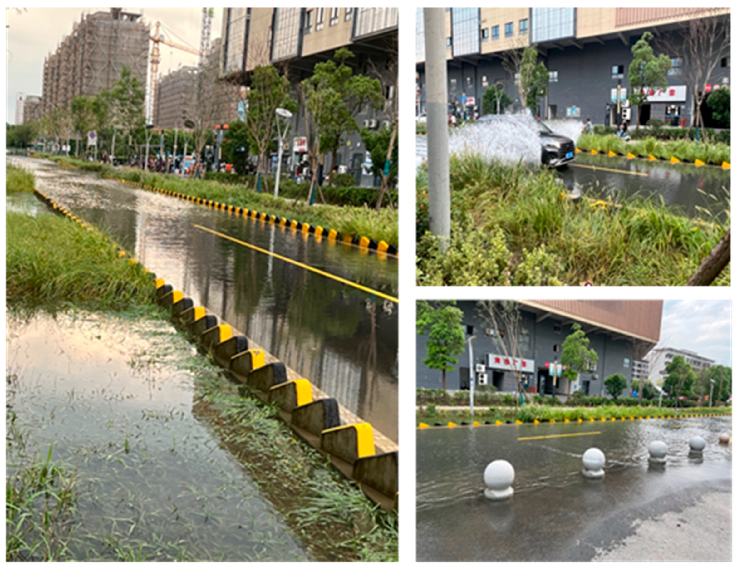
Figure 2. Flood occurrence after typhoon Muifa on 13 September and inundation of the swale. The Chinese characters on the photo means the company name only. Photo source: Lingwen Lu (approval given to use the photos).
Water 18 00427 g002
Figure 3. The flow chart of the methodology and coding of this study (Source: Xiaolei Pei and Faith Ka Shun Chan).
Water 18 00427 g003
Figure 4. Overall DT framework for the case of Ningbo, adopted by Peng [34].
Water 18 00427 g004
Figure 5. The regional refined rainfall interpretation data results of the Ningbo Meteorological Observatory, the Chinese terms in the diagram only means the districts of the catchment in Ningbo (source: authors).
Water 18 00427 g005
Figure 6. One-dimensional flood evolution model downstream of the reservoir (source: authors).
Water 18 00427 g006
Figure 7. Two-dimensional flood evolution model downstream of the reservoir, the blue colour shows the catchment and rivers of the area (source: authors).
Water 18 00427 g007
Figure 8. One-dimensional and two-dimensional flood coupling models downstream of the reservoir (source: authors).
Water 18 00427 g008
Table 1. The information of the interviewees (N = 11).
IntervieweeOccupation and CharacteristicsJob Nature
Engineer ASoftware Developer and System DesignerFocus on system architecture and software development, ensuring stable system design and scalable platform functions.
Engineer BLead on Core Business Logic and Operational SupportHandles business rule formulation, operational logic, and decision-support functions to align platform outcomes with real-world needs.
Engineer CFrontend Interface—User Experience and Functionality OptimisationResponsible for user-facing interface design, usability, and interaction workflows to ensure intuitive and efficient system operation
Engineer DBackend Developer—Model Integration and System CoordinationSpecialises in backend services, coordinating different models and ensuring smooth data exchange and system stability.
Engineer EHydrological and Hydrodynamic Modelling and Computational Core DeveloperWorks on hydrological and hydrodynamic model kernels, numerical solvers, and simulation engines for flood forecasting and water level prediction.
Engineer FHydrological and Hydrodynamic Modelling and Computational Core Developer (Hydrological Model)Focuses on hydrological modelling, operational rule simulation, and integrating reservoir management into system-wide hydrological forecasts.
Engineer JChief EngineerProvides overall technical oversight, ensures cross-team coordination, and manages strategic decision-making for system reliability.
Engineer HKnowledge Platform and Data System EngineerResponsible for knowledge management, data integration, and maintaining information-sharing systems within the platform.
Engineer IInfrastructure and Environmental System EngineerWorks on infrastructure-related models and environmental systems, ensuring the platform supports sustainable and resilient operations.
Scholar A


Scholar B
Dam and Water Scientist in Hydrology and Hydro-Ecology


Drainage and Flood Engineer
Responsible for the research of dams, water discharge and freshwater ecology
Responsible for drainage construction, modelling and flood management
Disclaimer/Publisher’s Note: The statements, opinions and data contained in all publications are solely those of the individual author(s) and contributor(s) and not of MDPI and/or the editor(s). MDPI and/or the editor(s) disclaim responsibility for any injury to people or property resulting from any ideas, methods, instructions or products referred to in the content.