Article

Enhanced Water–Root Coupling in Mongolian Pine Plantations Induced by Coal Mining Subsidence: A Comparative Study of Sand-Capped Loess and Sandy Soil


by
Yongjin Guo
1,2,†,
Haoyan Wei
2,†,
Jie Fang
2,3,*,
Min Li
2,
Zhenguo Xing
2,3 and
Da Lei
2,3
1
Shendong Coal Group of China Energy Co., Ltd., Shenmu 719315, China
2
State Key Laboratory of Water Resource Protection and Utilization in Coal Mining, Yulin 102209, China
3
National Institute of Clean-and-Low-Carbon Energy, Beijing 102211, China
*
Author to whom correspondence should be addressed.
These authors contributed equally to this work.
Water 2026, 18(2), 264; https://doi.org/10.3390/w18020264
Submission received: 22 December 2025 / Revised: 13 January 2026 / Accepted: 15 January 2026 / Published: 19 January 2026
(This article belongs to the Section Ecohydrology)

Abstract

Understanding the dynamics of soil water and root systems is essential for managing and restoring ecosystems impacted by coal mining subsidence. However, existing research treats soil and plant responses separately, also with limited comparisons across different soil types, which hampers our understanding of their coupled effects. We examined the distribution of plant roots, soil water content and stable isotopes within the root zone in the subsidence and non-subsidence plots located in mining areas with sand-capped loess and sandy soil. Our results show that coal mining subsidence induces cracks and fissures in both sand-capped loess and sandy soil, enhancing soil infiltration and increasing deep soil water (>1 m). The increase in deep soil water was more pronounced in sand-capped loess, where subsidence exhibited near-precipitation lc-excess values (−5.9‰ to −0.2‰) and also shifted the soil water infiltration mechanism from piston flow to preferential flow. Moreover, land subsidence provides a more suitable soil physical environment that supports the growth of deeper and more extensive plant roots. The coupling degree (D) between the soil water system and root system was significantly higher in subsidence areas (D > 0.4), indicating enhanced root water absorption. These changes benefit plant physiological activities and stress response, providing an adaptive mechanism for plants in subsidence regions. This study provides new insights into the effects of coal mining subsidence on the root-soil interface in Earth’s Critical Zones and serves as a foundation for ecological restoration and management in subsidence-impacted areas.

1. Introduction

Large-scale underground resource extraction generates sustained mechanical stress within overlying strata, culminating in land surface subsidence [1]. Beyond its visible topographic expression, this process fundamentally reorganizes the subsurface architecture of the Earth’s Critical Zone [2]. The resulting strain alters soil porosity, fractures bedrock, and disrupts established hydrological pathways [3]. In arid and semi-arid regions, where water is the primary limiting factor for ecosystem function, such perturbations can decisively shift the balance of water fluxes and reserves within the deep vadose zone [4].
The ecological consequences of these changes are mediated through the soil–plant continuum, specifically at the root–soil interface [5]. Here, two interdependent processes determine vegetation water status: the supply function, governed by soil hydraulic properties and water storage, and the acquisition function, determined by root system morphology and physiological activity [6,7]. Mining subsidence can potentially modify both: fracturing may enhance deep percolation [8], while compaction or shear could impede root growth [9]. Critically, the net outcome for plant water availability is not universal but is hypothesized to be contingent upon the intrinsic properties of the soil matrix, such as its texture and structure [10]. Fine-textured soils (e.g., loess) and coarse-textured soils (e.g., sand) differ dramatically in water retention, infiltration capacity, and mechanical resistance, likely engendering divergent ecosystem responses to the same subsidence stress [11].
Current understanding of subsidence impacts remains fragmented and often contradictory. Hydrological studies report conflicting results, from significant water table decline and surface drying to negligible changes in shallow soil moisture [12,13]. Similarly, vegetation responses range from widespread mortality to rapid recovery [6,7]. These inconsistencies may stem from two common methodological constraints. On the one hand, there is a deviation in shallow sampling, and the investigation is limited to the upper 1 m of the soil, overlooking the deep aeration zone that is crucial for the survival of trees [14,15]. On the other hand, the lack of soil science background and research conducted in a single soil type obscures the role of soil properties as key moderating variables [16]. More importantly, evaluating the effects of soil or vegetation individually will lead to an incomplete understanding of the ecosystem dynamics [17]. The coupling of soil water and root systems is widely recognized as a key characteristic of healthy, well-functioning ecosystems [18]. However, current research has largely overlooked the impacts of land subsidence on this soil water-root coupling.
Addressing this requires a comparative approach that holds climate constant while varying the soil substrate, thereby isolating the moderating effect of edaphic factors on the subsidence–ecosystem relationship. The Shendong Mining Area, straddling the margin of the Mu Us Sandy Land and the Loess Plateau, presents a unique natural experiment. The region experiences uniform climatic conditions but overlies two distinct Quaternary deposits: aeolian sands and loess [19]. This setting allows us to test the central hypothesis that soil type mediates the impact of mining subsidence on the deep root-zone water dynamics of woody vegetation. The objectives of this study were to (1) investigate the effects of coal mining-induced land subsidence on deep soil water; (2) examine how subsidence influences plant root growth; (3) assess the coupling effect of coal mining subsidence on soil water and root system. This would help to improve the knowledge of land subsidence impact and to provide a theoretical foundation for the development of ecological restoration strategies and vegetation management in coal mining subsidence areas.

2. Materials and Methods

2.1. Study Area

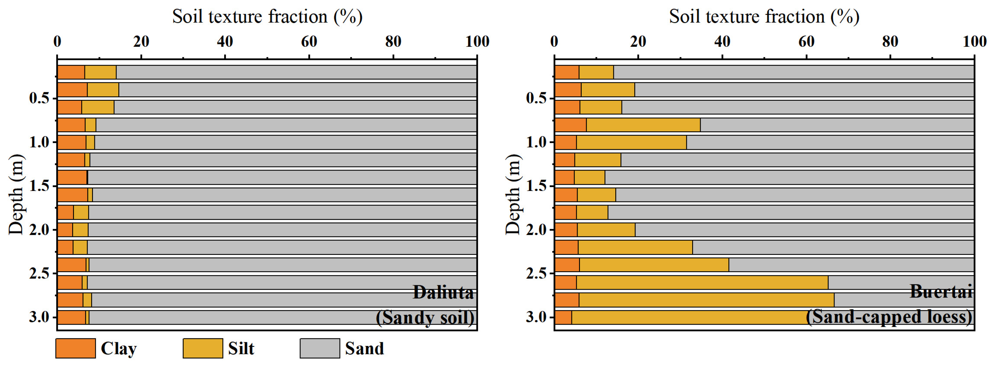
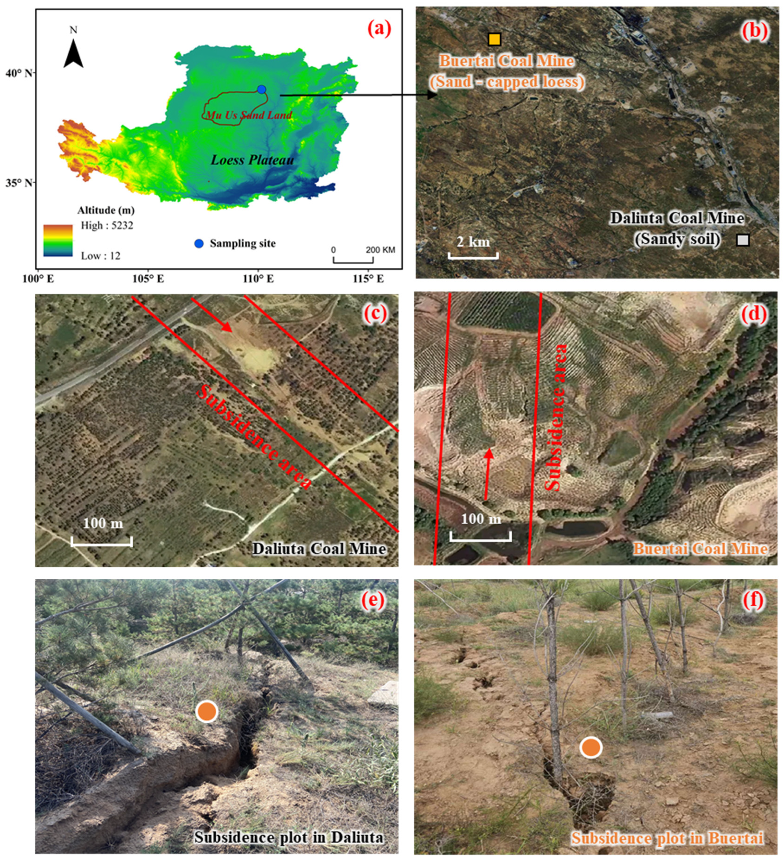
The study was conducted in the Shendong coal mining area (110.15° E, 39.23° N) at the border of Mu Us Desert and Loess Plateau, China. This region characterized by both wind and water erosion, representing a transitional zone from loess hilly areas to sandy regions (Figure 1a). Areas adjacent to the Mu Us Desert are predominantly characterized by homogeneous sandy soil, while in hilly regions, the surface is covered by a specific thickness of wind-blown sand overlying a loess layer, which is termed sand-capped loess [20,21]. This area experiences a temperate continental climate, marked by pronounced water deficit dynamics with annual precipitation below 400 mm, contrasting sharply against evaporation rates exceeding 1500 mm [7,22]. Daliuta Coal Mine and Buertai Coal Mine, located in sandy and hilly areas, respectively, were selected as two representative sampling areas (Figure 1b). Based on the United States Department of Agriculture texture classification [16], the soil profile in Daliuta Coal Mine (sandy soil) is highly uniform with depth. In contrast, for the soil profile in Buertai Coal Mine (sand-capped loess), the upper part is still dominated by sand, while the lower part has a lower sand content and a higher silt content (Figure 2). Both sampling zones have undergone significant underground coal extraction, leading to surface subsidence and visible cracks or fissures (Figure 1c–f).
In response to severe land desertification, large-scale afforestation efforts have been performed in the study area in recent decades [23]. Mongolian Pine (Pinus sylvestris var. mongolica), an evergreen conifer adapted to arid and semi-arid climates, is widely planted in northern China for afforestation purposes [19,22]. Thereby, the artificial Mongolian Pine plantations of the same stand age (6 years) in both subsidence and non-subsidence areas within the coal mine were selected in the two soil zones mentioned above, yielding four sampling plots. The subsidence sampling plots were selected within the subsidence area, characterized by visible ground fissures (Figure 1c–f). In contrast, non-subsidence plots were located outside the subsidence area but with consistent soil and vegetation, and within a distance of no more than 500 m (Figure 1c,d). The subsidence area has remained stable, with no new fractures or subsidence recorded in recent years. The trees at the different sampling sites were similar in height and diameter at breast height.

2.2. Root and Soil Sampling and Analysis

In each sampling area, three sub-sampling plots were strategically selected for root and soil sampling. For non-subsidence areas, three sub-sampling plots contained paired trees, and sampling locations were set at the midpoint between each pair of trees. This ensured consistent and representative selection across the entire undisturbed area. In contrast, for subsidence areas, stricter selection criteria were adopted to ensure that the collected soil profiles are clearly affected by subsidence disturbance. Besides following the midpoint selection criterion, the chosen location in each sub-plot must also intersect with ground fissures (Figure 1e,f). This approach enabled us to accurately capture the environmental changes directly resulting from subsidence, providing crucial insights into the impact of coal mining-induced land subsidence on soil and root systems. Root-soil samples were collected on 29 July 2024, using a 90 mm diameter soil auger at 20 cm intervals to a depth of 3 m, where root systems were sparse. A total of 180 root-soil samples were collected from 12 profiles. These samples were washed with tap water to separate roots from soil particles, with root collected using tweezers, scanned at 300 dpi, and processed using RhizoVision Explorer 2.0.3 to measure fine root length [24]. The root samples were then oven-dried at 60 °C for 72 h and weighed to determine the dry mass. Fine root length density (FRLD), representing the fine root length per unit soil volume (m m−3), and root mass density (RMD), representing the root dry weight per unit soil volume (g m−3).
To demonstrate temporal variability in soil water, soil samples were obtained on 29 July, 31 July, 2 August and 4 August 2024. These sampling campaigns encompassing two rainfall events with amounts of 33.6 mm and 64.7 mm, respectively, the data of which were derived from the nearby meteorological station. For each sampling event, three soil profiles were randomly drilled in each plot using a 60 mm diameter hand auger at 20 cm intervals down to 3 m layer depth. A portion of each sample was placed in an aluminum box and dried at 105 °C for 24 h to determine gravimetric soil water content (SWC), while the remaining portion was packed into 100 mL plastic bottles, and stored for isotopic analysis. Soil water was extracted using a vacuum condensation extraction system with a heating temperature of 205 °C and vacuum pressure below 1 Pa, ensuring a water recovery rate between 98% and 102%. Isotopic analysis of δ2H and δ18O was performed using an off-axis integrated cavity output spectroscopy water isotope analyzer (LWA-45EP, Los Gatos Research, Los Gatos, CA, USA). Measured values of δ18O and δ2H were expressed relative to Vienna Standard Mean Ocean Water (VSMOW).

2.3. Data Analysis

2.3.1. lc-Excess in Soil Water

lc-excess values were defined based on the local meteoric water line (LMWL) [25]:
lc e x c e s s = δ 2 H A δ 18 O B
where A and B are slope and intercept of LMWL, respectively. LMWL is δ2H = 7.67 δ18O + 5.91, R2 = 0.96 [26]. In general, negative lc-excess values indicate evaporative enrichment, with rainfall having an lc-excess of zero, and smaller lc-excess values reflecting greater evaporation influence.

2.3.2. Degree of Coupling Coordination Model

To evaluate the interaction between soil water and root system, the degree of coupling coordination model was applied. The model incorporates the degree of coupling (C), coordination index (T), and degree of coupling coordination (D). Because plant fine root length is the most effective indicator of plant root absorption capacity [27], using FRLD as the root system indicator. The key model indicators and formulas are as follows [18]:
C = { ( f s × f r ) / [ ( f s + f r ) / 2 ] 2 } 1 / 2
f s = w i s i
f r = w i r i
T = α 1 f s + α 2 f r
D = C × T
where C is the degree of coupling. fs and fr represent the comprehensive evaluation functions of SWC and FRLD, respectively. si and ri are the normalized values for the SWC and FRLD in layer i of soil, respectively, where wi is the weight. T denotes the coordination index. α1 and α2 are weighted coefficient, where soil water and root are assuming equally important for plant uptake, that is, α1 = α2 = 0.5. D is the degree of coupling coordination and ranges between 0 and 1. The higher the D value, the better is the coupling relationship of the soil water–root system. D values from 0 to 0.4 indicate the unbalanced development, 0.4 to 0.6 suggest transitional development, and 0.6 to 1.0 denote balanced development.

2.3.3. Statistical Analysis

The coefficient of variation (CV, %) was calculated to examine temporal changes in SWC and lc-excess values in soil water. Error propagation analysis was used to quantify uncertainty due to variability in SWC and FRLD data, impacting the D value. Paired t-tests were conducted to assess differences between subsidence and non-subsidence plots:
t = x ¯ y ¯ σ x 2 + σ y 2
where x ¯ and y ¯ are the means; and σ x and σ y are the standard errors of variables x and y, respectively. The statistical tests were considered significant when t > 1.96 (p < 0.05) and t > 2.58 (p < 0.01).

3. Results

3.1. Soil Water Content and lc-Excess Variations

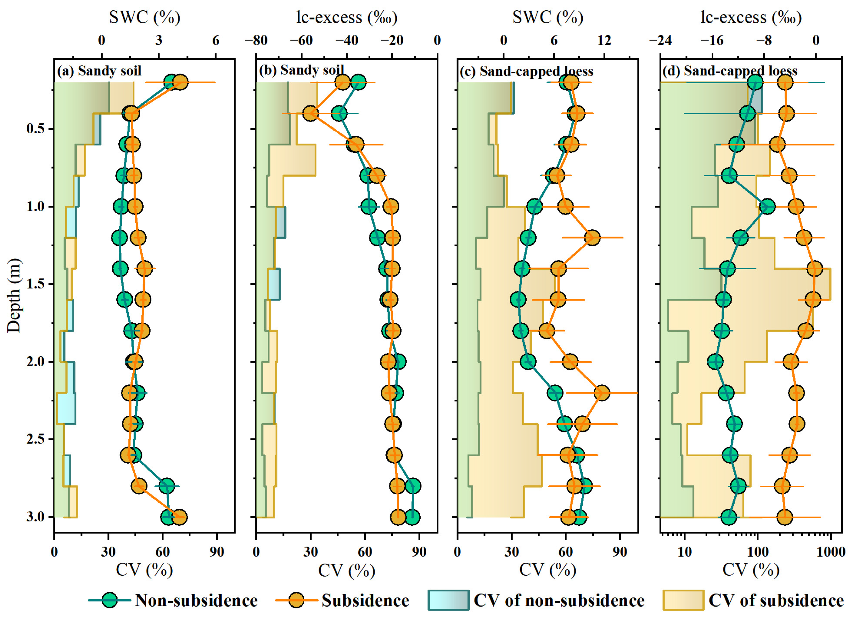
Distinct vertical and temporal patterns of soil water content (SWC) were observed between subsidence and non-subsidence plots, as well as across sandy soil and sand-capped loess zones (Figure 3a,c). In the sandy soil zone, SWC profiles were similar between subsidence and non-subsidence plots, with a statistically significant, but minimal-magnitude difference in the temporally averaged SWC within the 0.8–1.8 m layer. In contrast, the sand-capped loess zone exhibited a notable divergence: the non-subsidence plot had significantly lower SWC values (p < 0.05) in the 1.2–2.2 m layer compared to the subsidence plot. Temporal variability of SWC further differentiated the soil types. In the sandy soil zone, both plots exhibited similar coefficients of temporal variation (CV), with substantial fluctuations in the shallow layer (0–1 m, CV > 10%) and minimal variation in deeper layers (1–3 m, CV < 10%). In the sand-capped loess zone, the non-subsidence plot followed a comparable shallow-to-deep CV pattern, while the subsidence plot exhibited elevated CV values (22–54%) across all depths, indicating heightened temporal variability of SWC.
Similar patterns were observed for lc-excess (Figure 3b,d). In sandy soils, changes in lc-excess were comparable between subsidence and non-subsidence plots, with the greatest fluctuations in the shallow layer (0–1 m). As depth increased, temporal variability decreased, and values converged around −20‰ below 1 m, suggesting that hydrological processes in the deeper layers (1–3 m) remained largely unaffected by subsidence. In sand-capped loess zone, lc-excess values in the non-subsidence plot ranged from −15.5‰ to−7.5‰, with pronounced variability in the shallow soil and minimal changes at greater depths. In contrast, the subsidence plot exhibited near-precipitation lc-excess values (−5.9‰ to −0.2‰) with elevated CV across all depths, indicating a heightened sensitivity to precipitation infiltration. Notably, lc-excess values of approximately 0‰ at depth of 1.4–1.6 m in the subsided sand-capped loess zone suggest preferential flow reaching deeper soil layers. These findings highlight that subsidence-induced hydrological alterations, particularly enhanced the connectivity between precipitation and deep soil water, are strongly influenced by soil type.

3.2. Fine Root Length and Root Biomass Distribution

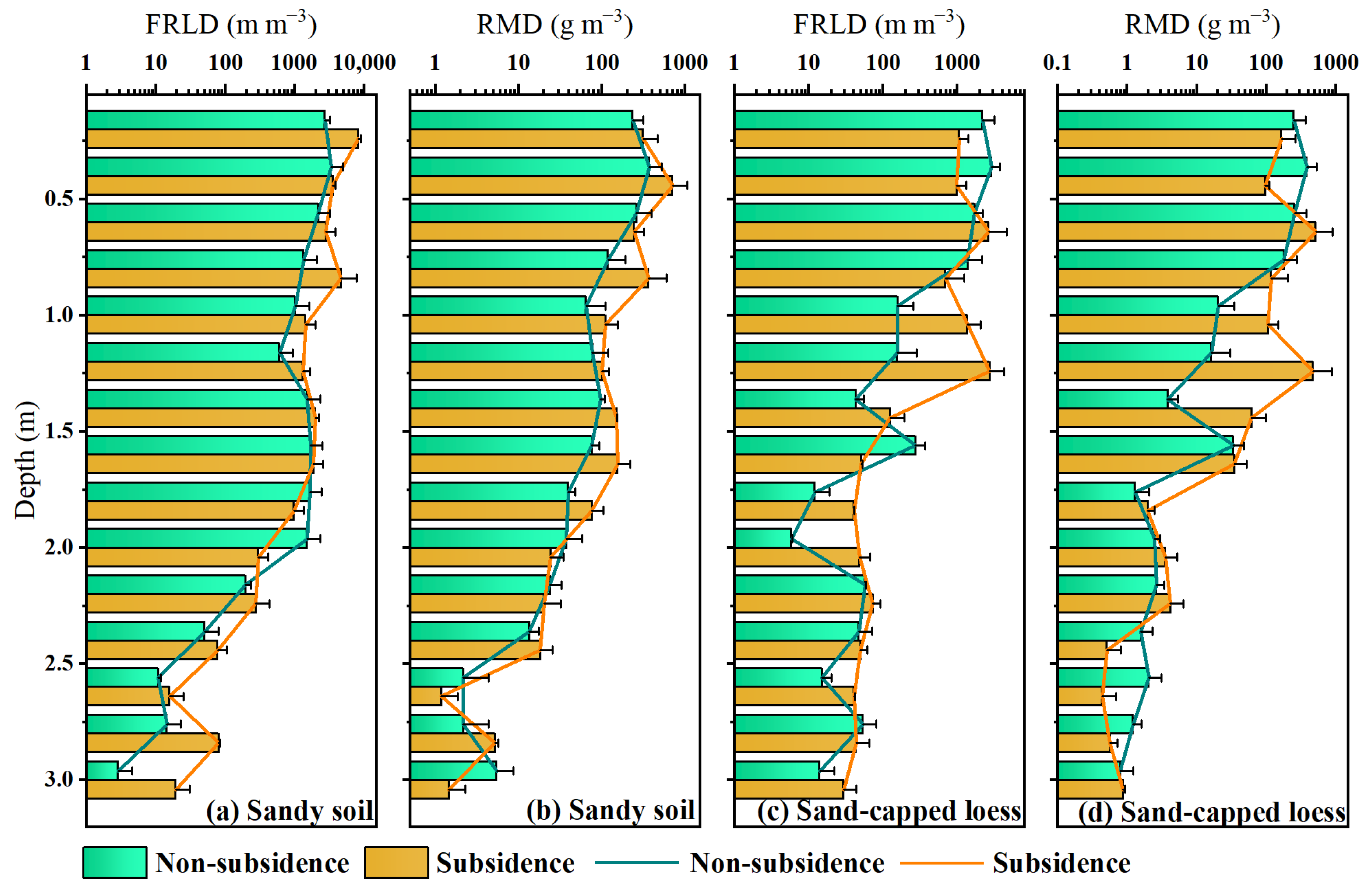
As shown in Figure 4, both fine root length density (FRLD) and root dry mass density (RMD) showed consistent decreasing trends with increasing soil depth in both subsidence and non-subsidence plots across the sandy soil and sand-capped loess regions. In the sandy soil region, the subsidence plot exhibited a slight increase in both FRLD and RMD, although these parameters remained generally similar to those in the non-subsidence plot. In contrast, the sand-capped loess region displayed more pronounced differences, with subsidence plots showing significantly higher FRLD and RMD values (p < 0.05) at certain depths (e.g., 1–1.5 m) compared to the undisturbed areas. This differential response between soil types underscores the crucial role of soil matrix characteristics in shaping root adaptation mechanisms following subsidence.

3.3. Soil Water-Root Degree of Coupling Coordination

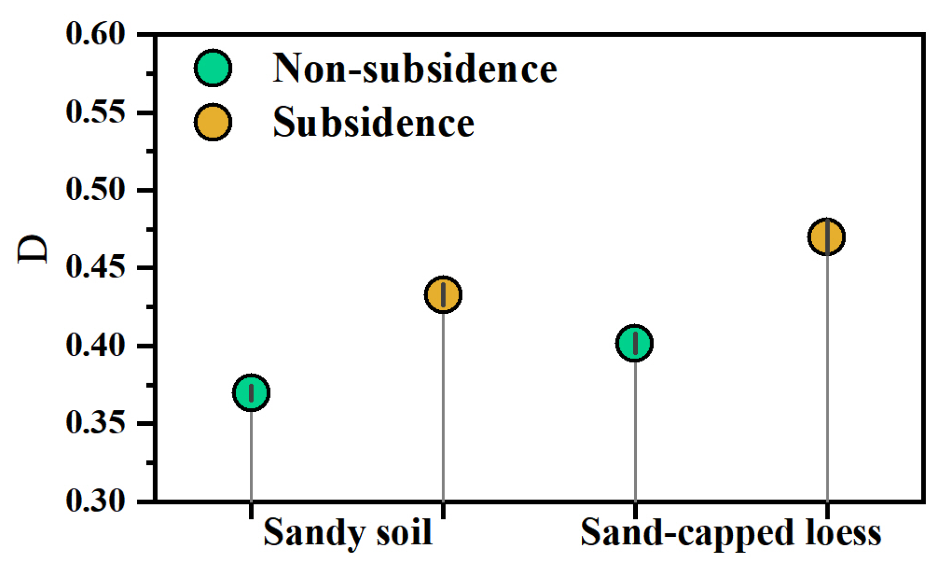
Figure 5 illustrates the D values of the SWC and FRLD under the influence of subsidence in two soil types. Across both soil types, the D values in the subsidence plots were significantly higher than those in the non-subsidence plots (p < 0.01), indicating that coal mining subsidence had enhanced the overall coupling degree between the plant root system and the soil water system. In the sandy region, subsidence shifted the system from unbalanced development (D < 0.4), increasing D values from 0.37 ± 0.00 (non-subsidence) to 0.43 ± 0.01 (subsidence), thus moving the system into a transitional phase (0.4 ≤ D < 0.6). In the sand-capped loess region, subsidence facilitated a shift toward balanced development, with D values rising from 0.40 ± 0.01 (non-subsidence) to 0.47 ± 0.01 (subsidence). This suggests that zones with greater root system development in plants are associated with higher water availability for uptake.

4. Discussion

4.1. Effect of Subsidence on Soil Water

Our data reveal a fundamental alteration in deep vadose zone hydrology resulting from mining-induced subsidence. Specifically, soil water storage below 1 m depth exhibited a marked positive shift in subsidence plots relative to undisturbed control sites (Figure 3). Our observation aligns with earlier investigations [8], which underscore subsidence’s function in boosting deep soil moisture—an outcome tightly linked to vadose zone structural reconfiguration induced by underground coal mining activities. The underlying mechanism for this enhancement is attributed to subsidence-driven fracturing of the soil and regolith profile. The resultant network of macropores and fissures establishes efficient conduits for preferential flow, effectively bypassing the soil matrix and facilitating the rapid vertical transfer of incident precipitation into deeper strata [4,28]. Consequently, the deep subsurface shifts from a region of slow, diffusion-limited moisture movement to one influenced by episodic, rapid recharge events.
Crucially, the magnitude of this hydrological change is not uniform but is profoundly mediated by the native soil’s physical architecture. In the sandy soil region, the increase in deep water content was quantitatively lower (Figure 3). This attenuated response stems from the intrinsic properties of the coarse-textured matrix: high innate hydraulic conductivity and weak water retention due to low matric potential [29,30]. The loose, cohesionless fabric of sand undergoes limited pore reorganization under subsidence stress, thereby constraining the potential for change in its water storage dynamics.
In contrast, the sand-capped loess site displayed a significantly more pronounced hydrological response. Loess, with its higher silt/clay fraction and greater structural coherence, experiences a more transformative pore-space restructuring under mechanical stress [20,31]. Subsidence in this medium generates new, stable void spaces that enhance not only infiltration capacity but also the water-holding potential of the deep profile. This differential outcome underscores a key principle: the final hydrogeological impact of subsidence is a product of the interaction between the deformation process and the pre-existing textural and structural properties of the soil substrate.

4.2. Effect of Subsidence on Root Systems

Root system architecture exhibited significant morphological plasticity in response to subsidence, with the direction and magnitude of change being critically dependent on soil lithology. While the expected pattern of exponential root biomass attenuation with depth was maintained in sandy soils—regardless of subsidence status—and in non-subsided loess, a fundamentally different profile emerged in subsided loess (Figure 4). Here, both fine root length density and root mass showed a pronounced subsurface peak before declining, indicating a targeted investment in deep soil exploration. This observed divergence points to a soil-specific facilitation mechanism. In cohesive loess, subsidence-induced fracturing likely creates a network of persistent macropores. These structural modifications serve a dual function: they significantly reduce mechanical impedance for root tip penetration, and concurrently act as hydrologically privileged pathways channeling both water and roots into deeper strata [32]. The resulting environment effectively signals the plant to reallocate carbon resources toward subsoil foraging [33,34]. Conversely, the lack of a similar response in sandy soils underscores the importance of matrix stability. Sand’s inherently loose, non-cohesive fabric may prevent the formation of sustained, physically guided pore networks following disturbance. While water infiltration might increase, the absence of stable conduits fails to provide the necessary architectural cues or low-resistance pathways to systemically redirect root growth downward. Thus, the root system’s reorganization is not a passive consequence of altered water availability alone, but an active morphological adaptation to a reconfigured physical habitat. This plasticity highlights how subsidence can functionally re-engineer the rhizosphere, with the native soil’s physical integrity determining whether this engineering promotes a strategic deepening of the root system.

4.3. Effects of Subsidence on Soil Water-Root Coupling

The interaction between soil water and roots is a key determinant of plant water uptake and overall physiological performance [35,36]. Improved coupling between soil moisture and roots enhances a plant’s ability to access water, especially from deeper soil layers. In this study, the coupling degree between soil water content (SWC) and fine root length density (FRLD) was significantly higher in the subsidence plots compared to the non-subsidence plots (Figure 5). This suggests that coal mining subsidence improves the root system’s ability to access deep soil water, shifting plant water uptake strategies towards deeper layers. The observed increase in the coupling degree indicates that subsidence facilitates deeper root water absorption, likely through improved water availability in deep soil layers. This shift towards deeper water uptake is particularly beneficial under drought conditions, as it enhances the plant’s drought resistance by utilizing deep soil water reserves [37,38,39]. The increased coupling between soil water and roots in subsidence plots suggests that plants in these areas may be better equipped to withstand water stress, particularly in arid mining regions where surface water availability is limited [40,41]. Although our findings contrast with certain prior studies indicating that coal mining subsidence negatively affects vegetation growth and development [6,42], this discrepancy may be attributed to the previous neglect of deep soil layers and the deep root systems of trees. This phenomenon was further confirmed by isotopic labeling experiments, which showed that plants in subsidence plots sourced water from deeper layers than those in non-subsidence plots [13]. These findings suggest that coal mining subsidence may have positive ecological implications by improving plants’ access to deep water resources, thus supporting plant survival and productivity, especially during dry spells.

4.4. Limitations

This study investigated the beneficial effects of subsidence disturbance on soil moisture, root systems, and plant water use. However, it is important to recognize that the positive impacts of coal mining subsidence are accompanied by potential risks such as soil instability, root exposure, and alterations to carbon and nutrient cycling [43]. In addition, due to the lack of systematic measurements of soil structure, pore morphology, and hydraulic properties in subsidence-affected areas, the mechanistic interpretation of the observed processes remains uncertain. In particular, the absence of key parameters—such as soil pore connectivity, aggregate stability, and root–soil contact relationships—may have limited our ability to fully understand the pathways of water movement and the adaptive strategies of roots under subsidence disturbance. Future research should employ advanced techniques such as CT scanning, X-ray microtomography, or pore network modeling to quantitatively characterize soil structure in subsidence regions [44]. Combining in situ monitoring with numerical simulations will help to improve our understanding of how subsidence disturbance regulates water transport within the soil–plant continuum [41]. Furthermore, long-term field observations of the recovery of ecosystem structure and function following subsidence events are crucial for a more comprehensive assessment of the ecological impacts and long-term sustainability of such disturbances [45].

5. Conclusions

This study investigated soil and root profiles up to 3 m deep from both subsidence and non-subsidence plots in mining areas with sandy soil and sand-capped loess. Our findings show that coal mining subsidence significantly impacts soil water dynamics and root development, with notable differences observed between sandy soil and sand-capped loess. Subsidence enhances deep soil water availability, particularly in sand-capped loess, by altering the vadose zone structure and facilitating preferential flow pathways. These changes also promote deeper root growth and increase the coupling between soil water and root systems, improving the plant’s ability to access deep water resources and enhancing drought resistance. The findings suggest that coal mining subsidence can have beneficial effects on soil water availability and plant water uptake, particularly in arid regions where water resources are scarce. These insights contribute to a better understanding of subsidence-induced ecological changes and provide valuable information for sustainable land and water resource management in mining-affected areas.

Author Contributions

Conceptualization, M.L. and H.W.; methodology, Y.G., Z.X. and H.W.; software, Y.G. and D.L.; validation, Y.G., Z.X. and M.L.; formal analysis, Y.G.; investigation, H.W. and Z.X.; re-sources, D.L. and Z.X.; data curation, H.W.; writing—original draft preparation, Y.G. and H.W.; writing—review and editing, J.F.; visualization, H.W.; supervision, M.L.; project administration, J.F.; funding acquisition, M.L. All authors have read and agreed to the published version of the manuscript.

Funding

This research was funded by 2024 Annual Project for Scientific and Technological Innovation Capacity Development of National Key Laboratory, grant number GJNY-24-34.

Data Availability Statement

The raw data supporting the conclusions of this article will be made available by the authors on request.

Acknowledgments

Authors thank the technical help from Jingjing Jin and Min Wang, Institute of Water-saving Agriculture in Arid Areas of China, Northwest A&F University.

Conflicts of Interest

Author Yongjin Guo from Shendong Coal Group of China Energy Co., Ltd. The remaining authors declare that the research was conducted in the absence of any commercial or finical relationships that could be construed as potential conflicts of interests.

References

  1. Salami, O.B.; Kumar, A.R.; Aamir, I.; Pushparaj, R.I.; Xu, G. Enhancing Fire Safety in Underground Mines: Experimental and Large Eddy Simulation of Temperature Attenuation, Gas Evolution, and Bifurcation Influence for Improved Emergency Response. Process Saf. Environ. Prot. 2024, 183, 260–273. [Google Scholar] [CrossRef]
  2. Wang, X.; Peng, S.; He, Y. Research on the Upward Transport of Vadose Water Based on Isotope Technology: A Case Study of Mining Subsidence Area in Shendong Mining Area. Earth Sci. Inf. 2025, 18, 455. [Google Scholar] [CrossRef]
  3. Yang, J.; Wei, H.; Quan, Z.; Xu, R.; Wang, Z.; He, H. A Global Meta-Analysis of Coal Mining Studies Provides Insights into the Hydrologic Cycle at Watershed Scale. J. Hydrol. 2023, 617, 129023. [Google Scholar] [CrossRef]
  4. Xiang, W.; Si, B.C.; Biswas, A.; Li, Z. Quantifying Dual Recharge Mechanisms in Deep Unsaturated Zone of Chinese Loess Plateau Using Stable Isotopes. Geoderma 2019, 337, 773–781. [Google Scholar] [CrossRef]
  5. Bi, Y.; Zhang, J.; Song, Z.; Wang, Z.; Qiu, L.; Hu, J.; Gong, Y. Arbuscular Mycorrhizal Fungi Alleviate Root Damage Stress Induced by Simulated Coal Mining Subsidence Ground Fissures. Sci. Total Environ. 2019, 652, 398–405. [Google Scholar] [CrossRef]
  6. Liu, Y.; Lei, S.G.; Chen, X.Y.; Chen, M.; Zhang, X.Y.; Long, L.L. Disturbance Mechanism of Coal Mining Subsidence to Typical Plants in a Semiarid Area Using O-J-I-P Chlorophyll a Fluorescence Analysis. Photosynthetica 2020, 58, 1178–1187. [Google Scholar] [CrossRef]
  7. He, Y.; He, X.; Liu, Z.; Zhao, S.; Bao, L.; Li, Q.; Yan, L. Coal Mine Subsidence Has Limited Impact on Plant Assemblages in an Arid and Semi-Arid Region of Northwestern China. Écoscience 2017, 24, 91–103. [Google Scholar] [CrossRef]
  8. Zhang, K.; Liu, S.; Bai, L.; Cao, Y.; Yan, Z. Effects of Underground Mining on Soil–Vegetation System: A Case Study of Different Subsidence Areas. Ecosyst. Health Sustain. 2023, 9, 0122. [Google Scholar] [CrossRef]
  9. Wei, H.; Ding, X.; Cao, K.; Lai, H.; Wang, L.; Li, M. Impact of Drought and Root Excision on Root Regeneration, Xylem Hydraulics and Leaf Physiological Characteristics in Robinia pseudoacacia. Plant Soil. 2025, 517, 1643–1654. [Google Scholar] [CrossRef]
  10. Guo, Z.; Li, P.; Yang, X.; Wang, Z.; Lu, B.; Chen, W.; Wu, Y.; Li, G.; Zhao, Z.; Liu, G.; et al. Soil Texture Is an Important Factor Determining How Microplastics Affect Soil Hydraulic Characteristics. Environ. Int. 2022, 165, 107293. [Google Scholar] [CrossRef]
  11. Adamczewski, R.; Kaestner, A.; Zarebanadkouki, M. Rhizosphere Hydraulic Regulation in Maize: Tailoring Rhizosphere Properties to Varying Soil Textures and Moistures. Plant Soil. 2024, 509, 53–66. [Google Scholar] [CrossRef]
  12. Wei, H.; Lu, Y.; Bai, L.; Niu, J.; Chen, S.; Mojid, M.A.; Yang, Y.; Li, M. Water Uptake Characteristics of Stipa Bungeana Trin: Affected by Subsidence in the Coal Mining Areas of Northwest China. Agronomy 2024, 14, 424. [Google Scholar] [CrossRef]
  13. Chen, G.; Guo, J.; Song, Z.; Feng, H.; Chen, S.; Li, M. Soil Water Transport and Plant Water Use Patterns in Subsidence Fracture Zone Due to Coal Mining Using Isotopic Labeling. Environ. Earth Sci. 2022, 81, 310. [Google Scholar] [CrossRef]
  14. Fan, Y.; Miguez-Macho, G.; Jobbágy, E.G.; Jackson, R.B.; Otero-Casal, C. Hydrologic Regulation of Plant Rooting Depth. Proc. Natl. Acad. Sci. USA 2017, 114, 10572–10577. [Google Scholar] [CrossRef]
  15. Mailloux, G.A.; Chikomo, M.; Fan, Y. Where Do We Expect to Find Deep Plant Roots? Ecography 2025, 2025, e08034. [Google Scholar] [CrossRef]
  16. Wankmüller, F.J.P.; Delval, L.; Lehmann, P.; Baur, M.J.; Cecere, A.; Wolf, S.; Or, D.; Javaux, M.; Carminati, A. Global Influence of Soil Texture on Ecosystem Water Limitation. Nature 2024, 635, 631–638, Correction in Nature 2025, 641, E4. [Google Scholar] [CrossRef]
  17. Cao, Y.; Xie, Z.; Woodgate, W.; Ma, X.; Cleverly, J.; Pang, Y.; Qin, F.; Huete, A. Ecohydrological Decoupling of Water Storage and Vegetation Attributed to China’s Large-Scale Ecological Restoration Programs. J. Hydrol. 2022, 615, 128651. [Google Scholar] [CrossRef]
  18. Sun, R.; Ma, J.; Sun, X.; Zheng, L.; Bai, S. Responses of Soil Water–Root Coupling and Coupling Effects on Grapevines to Irrigation Methods in Extremely Arid Region. Agric. Water Manag. 2024, 302, 108984. [Google Scholar] [CrossRef]
  19. Pei, Y.; Huang, L.; Shao, M.; Zhang, Y.; Pan, Y. Water Use Pattern and Transpiration of Mongolian Pine Plantations in Relation to Stand Age on Northern Loess Plateau of China. Agric. For. Meteorol. 2023, 330, 109320. [Google Scholar] [CrossRef]
  20. Tong, Y.; Wang, Y.; Zhou, J.; Guo, X.; Wang, T.; Xu, Y.; Sun, H.; Zhang, P.; Li, Z.; Lauerwald, R. Dataset of Soil Hydraulic Parameters in the Yellow River Basin Based on in Situ Deep Sampling. Sci. Data 2024, 11, 740. [Google Scholar] [CrossRef]
  21. Zhao, C.; Shao, M.; Jia, X.; Zhang, C. Particle Size Distribution of Soils (0–500cm) in the Loess Plateau, China. Geoderma Reg. 2016, 7, 251–258. [Google Scholar] [CrossRef]
  22. Pei, Y.; Huang, L.; Shao, M.; Jia, X.; Tang, X.; Zhang, Y.; Pan, Y. Water Sources Used by Artificial Salix Psammophila in Stands of Different Ages Based on Stable Isotope Analysis in Northeastern Mu Us Sandy Land. CATENA 2023, 226, 107087. [Google Scholar] [CrossRef]
  23. Wang, Z.; Xu, D.; Peng, D.; Zhang, X. Future Climate Change Would Intensify the Water Resources Supply-Demand Pressure of Afforestation in Inner Mongolia, China. J. Clean. Prod. 2023, 407, 137145. [Google Scholar] [CrossRef]
  24. Seethepalli, A.; Dhakal, K.; Griffiths, M.; Guo, H.; Freschet, G.T.; York, L.M. RhizoVision Explorer: Open-Source Software for Root Image Analysis and Measurement Standardization. AoB PLANTS 2021, 13, plab056. [Google Scholar] [CrossRef]
  25. Landwehr, J.M.; Coplen, T.B. Line-Conditioned Excess: A New Method for Characterizing Stable Hydrogen and Oxygen Isotope Ratios in Hydrologic Systems. In Isotopes in Environmental Studies; IAEA-CN-118/56; IAEA: Vienna, Austria, 2006; pp. 132–135. [Google Scholar]
  26. Zhao, Y.; Dai, J.; Tang, Y.; Wang, L. Illuminating Isotopic Offset between Bulk Soil Water and Xylem Water under Different Soil Water Conditions. Agric. For. Meteorol. 2022, 325, 109150. [Google Scholar] [CrossRef]
  27. Addo-Danso, S.D.; Defrenne, C.E.; McCormack, M.L.; Ostonen, I.; Addo-Danso, A.; Foli, E.G.; Borden, K.A.; Isaac, M.E.; Prescott, C.E. Fine-Root Morphological Trait Variation in Tropical Forest Ecosystems: An Evidence Synthesis. Plant Ecol. 2020, 221, 1–13. [Google Scholar] [CrossRef]
  28. Wiekenkamp, I.; Huisman, J.A.; Bogena, H.R.; Lin, H.S.; Vereecken, H. Spatial and Temporal Occurrence of Preferential Flow in a Forested Headwater Catchment. J. Hydrol. 2016, 534, 139–149. [Google Scholar] [CrossRef]
  29. El-Nagar, D.A.; Mohamed, R.A.A. Characterization and Impact of Cattle Manure Particle Size on Physical Properties of Sandy Soils. J. Geosci. Environ. Prot. 2019, 7, 180–194. [Google Scholar] [CrossRef]
  30. Fu, G.; Qiu, X.; Xu, X.; Zhang, W.; Zang, F.; Zhao, C. The Role of Biochar Particle Size and Application Rate in Promoting the Hydraulic and Physical Properties of Sandy Desert Soil. CATENA 2021, 207, 105607. [Google Scholar] [CrossRef]
  31. Li, Y.; Shi, W.; Aydin, A.; Beroya-Eitner, M.A.; Gao, G. Loess Genesis and Worldwide Distribution. Earth-Sci. Rev. 2020, 201, 102947. [Google Scholar] [CrossRef]
  32. Lu, Y.; Si, B.; Li, H.; Biswas, A. Elucidating Controls of the Variability of Deep Soil Bulk Density. Geoderma 2019, 348, 146–157. [Google Scholar] [CrossRef]
  33. Gale, M.R.; Grigal, D.F. Vertical Root Distributions of Northern Tree Species in Relation to Successional Status. Can. J. For. Res. 2011, 17, 829–834. [Google Scholar] [CrossRef]
  34. Pierret, A.; Maeght, J.-L.; Clément, C.; Montoroi, J.-P.; Hartmann, C.; Gonkhamdee, S. Understanding Deep Roots and Their Functions in Ecosystems: An Advocacy for More Unconventional Research. Ann. Bot. 2016, 118, 621–635. [Google Scholar] [CrossRef]
  35. Demir, G.; Guswa, A.J.; Filipzik, J.; Metzger, J.C.; Römermann, C.; Hildebrandt, A. Root Water Uptake Patterns Are Controlled by Tree Species Interactions and Soil Water Variability. Hydrol. Earth Syst. Sci. 2024, 28, 1441–1461. [Google Scholar] [CrossRef]
  36. He, N.; Gao, X.; Guo, D.; Wu, Y.; Ge, D.; Zhao, L.; Tian, L.; Zhao, X. The Dimensions of Deep-Layer Soil Desiccation and Its Impact on Xylem Hydraulic Conductivity in Dryland Tree Plantations. Hydrol. Earth Syst. Sci. 2024, 28, 1897–1914. [Google Scholar] [CrossRef]
  37. Gessler, A.; Bächli, L.; Rouholahnejad Freund, E.; Treydte, K.; Schaub, M.; Haeni, M.; Weiler, M.; Seeger, S.; Marshall, J.; Hug, C.; et al. Drought Reduces Water Uptake in Beech from the Drying Topsoil, but No Compensatory Uptake Occurs from Deeper Soil Layers. New Phytol. 2022, 233, 194–206. [Google Scholar] [CrossRef]
  38. Liu, Z.; Ye, L.; Jiang, J.; Liu, R.; Xu, Y.; Jia, G. Increased Uptake of Deep Soil Water Promotes Drought Resistance in Mixed Forests. Plant Cell Environ. 2023, 46, 3218–3228. [Google Scholar] [CrossRef]
  39. Yang, M.; Gao, X.; Wang, S.; Zhang, X.; Cai, Y.; Song, X.; Siddique, K.H.M.; Zhao, X. Photosynthetic Response to Deep Soil Water Deficit in a Semiarid Apple Tree Plantation. J. Hydrol. 2023, 617, 129161. [Google Scholar] [CrossRef]
  40. Liu, S.; Li, W. Zoning and Management of Phreatic Water Resource Conservation Impacted by Underground Coal Mining: A Case Study in Arid and Semiarid Areas. J. Clean. Prod. 2019, 224, 677–685. [Google Scholar] [CrossRef]
  41. Bai, X.; Jia, X.; Jia, Y.; Shao, M.; Hu, W. Modeling Long-Term Soil Water Dynamics in Response to Land-Use Change in a Semi-Arid Area. J. Hydrol. 2020, 585, 124824. [Google Scholar] [CrossRef]
  42. Liu, Y.; Gong, C.; Pei, W.; Fan, K.; Shen, W. Chlorophyll a Fluorescence as a Tool to Monitor Physiological Status in the Leaves of Artemisia Ordosica under Root Cutting Conditions. Front. Plant Sci. 2024, 14, 1308209. [Google Scholar] [CrossRef]
  43. de Vries, F.T.; Williams, A.; Stringer, F.; Willcocks, R.; McEwing, R.; Langridge, H.; Straathof, A.L. Changes in Root-Exudate-Induced Respiration Reveal a Novel Mechanism through Which Drought Affects Ecosystem Carbon Cycling. New Phytol. 2019, 224, 132–145. [Google Scholar] [CrossRef]
  44. Ceperley, N.; Gimeno, T.E.; Jacobs, S.R.; Beyer, M.; Dubbert, M.; Fischer, B.; Geris, J.; Holko, L.; Kübert, A.; Le Gall, S.; et al. Toward a Common Methodological Framework for the Sampling, Extraction, and Isotopic Analysis of Water in the Critical Zone to Study Vegetation Water Use. WIREs Water 2024, 11, e1727. [Google Scholar] [CrossRef]
  45. Wang, J.; Wang, P.; Qin, Q.; Wang, H. The Effects of Land Subsidence and Rehabilitation on Soil Hydraulic Properties in a Mining Area in the Loess Plateau of China. CATENA 2017, 159, 51–59. [Google Scholar] [CrossRef]
Figure 1. Location of study area (a), sampling sites of sandy soil and sand-capped loess (b), subsidence area extent (c,d), and pictures of subsidence plot (e,f). The red arrow represents the direction of underground mining, and the red solid line represents the boundary of the subsidence area. The orange dots represent sampling point locations.
Water 18 00264 g001
Figure 2. Soil texture fraction of sandy soil and sand-capped loess profile.
Water 18 00264 g002
Figure 3. Vertical distribution and coefficient of temporal variation in the gravimetric soil water content (SWC) and lc-excess value under subsidence and non-subsidence plots in sandy soil and sand-capped loess zones. Error bars represent the standard deviation of the temporal mean.
Water 18 00264 g003
Figure 4. Vertical distribution of the fine root length density (FRLD) and Root dry mass density (RMD) under subsidence and non-subsidence plots in sandy soil and sand-capped loess zones. Error bars represent the standard error of the mean.
Water 18 00264 g004
Figure 5. Coupling coordination degree (D) of soil water and fine root length under different plots. Error bars represent the standard error of D.
Water 18 00264 g005
Disclaimer/Publisher’s Note: The statements, opinions and data contained in all publications are solely those of the individual author(s) and contributor(s) and not of MDPI and/or the editor(s). MDPI and/or the editor(s) disclaim responsibility for any injury to people or property resulting from any ideas, methods, instructions or products referred to in the content.