Article

The Social Dimensions of Changing Water Levels in the Mackenzie River Basin


by
Kristine Wray
1,*,
Brenda Parlee
1,2,
MRBB Traditional Knowledge and Strengthening Partnerships Steering Committee
and
Tracy Howlett
1,3
1
Department of Resource Economics and Environmental Sociology, Faculty of Agriculture, Life, and Environmental Sciences, University of Alberta, Edmonton, AB T6G 2R3, Canada
2
Department of Natural Resource Sciences, Bieler School of Environment, McGill University, Montreal, QC H9X 3V9, Canada
3
Faculty of Native Studies, University of Alberta, Edmonton, AB T6G 2H8, Canada
*
Author to whom correspondence should be addressed.
Water 2026, 18(13), 1642; https://doi.org/10.3390/w18131642
Submission received: 13 April 2026 / Revised: 22 June 2026 / Accepted: 29 June 2026 / Published: 6 July 2026
(This article belongs to the Section Hydrology)

Abstract

Hydrological conditions in the Mackenzie River Basin (MRB) are becoming increasingly variable due to climate change, permafrost degradation, and cumulative industrial impacts. While scientific assessments have documented many of these trends, far less is known about how changing water levels and flow patterns affect the daily lives, livelihoods, and cultural responsibilities of Indigenous Peoples across the Basin. This paper synthesizes basin wide Indigenous Knowledge related to water level and flow variability, drawing on 31 Indigenous-led research projects. The analysis highlights shared concerns across regions, including reduced travel safety, restricted access to harvesting areas, shifting river and lake behaviour, and emotional and spiritual impacts associated with hydrological extremes. These observations align with scientific evidence of earlier breakup, prolonged low-water periods, and increased hydrological unpredictability, while also revealing social and cultural dimensions not captured through conventional monitoring. By synthesizing basin wide Indigenous Knowledge of water level and flow variability, this study provides new insight into the cumulative social ecological consequences of freshwater change in the MRB and underscores the importance of Indigenous-led research and governance in responding to accelerating hydrological variability.

1. Introduction

Freshwater systems across the circumpolar North are undergoing rapid and uneven hydrological change driven by climate warming, shifting precipitation regimes, permafrost degradation, and cumulative industrial impacts [1,2,3,4,5]. These changes are acutely visible in the Mackenzie River Basin (MRB), where communities have experienced unprecedented floods, prolonged low-water periods, altered ice conditions, and disruptions to travel and harvesting [6,7,8,9]. For Indigenous Peoples whose relationships with rivers, lakes, and wetlands are grounded in generations of land-based practice, these shifts are not only biophysical phenomena but deeply social, cultural, and spiritual concerns [10,11,12,13]. Understanding how hydrological variability is observed, interpreted, and lived within Indigenous Knowledge systems is therefore essential for anticipating the social-ecological consequences of freshwater change.
Scientific research has documented many aspects of hydrological variability in the MRB, including changing snowmelt dynamics, altered flow regimes, and the impacts of permafrost thaw on surface and groundwater systems [1,2,7,14]. However, these assessments often emphasize biophysical indicators—discharge, water quality, ice thickness—while giving less attention to the social dimensions of hydrological change. Existing monitoring frameworks in the MRB tend to prioritize standardized metrics for cumulative effects assessment and regulatory decision-making [15,16,17], leaving gaps in understanding how water-level change affects mobility, safety, harvesting access, cultural continuity, and wellbeing. However, there are some examples of monitoring programs that are exploring a wider set of indicators, led by the example of the Northern River Basins Study [16] and Indigenous Guardians programs.
At the same time, much of the Indigenous Knowledge research in the MRB has been conducted at local or sub-basin scales, including studies in the Mackenzie Delta [6], the Sahtú region [18], the Peace–Athabasca Delta [8,19,20], and the Dehcho [21,22]. These studies provide rich insight into place-based observations of water, ice, and fish, but the cumulative patterns that emerge across regions remain under-examined. Earlier basin-scale efforts, such as the Northern River Basins Study and the Mackenzie River Basin Board’s State of the Aquatic Ecosystem Reports [7,11], documented Indigenous concerns about water levels and ecological change, yet did not synthesize the social implications of hydrological variability across the Basin.
This paper addresses these gaps by synthesizing Indigenous Knowledge of water-level and flow variability across the MRB, drawing on 12 Indigenous-led research projects and seven graduate theses conducted between the 1990s and 2019 [10,11,12]. Unlike previous work that focuses on community-based monitoring methods or indicator development [20,23], this analysis centers on hydrological change itself—how it is experienced, how it affects daily life, and how it shapes relationships with water. The dataset also includes reflections on recent extreme events, such as the 2020 Fort McMurray flood, the 2022 Hay River flood, and the low-water and wildfire conditions of 2023, offering insight into the accelerating pace and complexity of freshwater change [1,7,9].
By examining patterns across regions and knowledge systems, this study provides a basin-wide understanding of the social dimensions of hydrological variability. The findings highlight the interconnectedness of water levels, travel safety, harvesting practices, cultural responsibilities, and emotional and spiritual wellbeing [6,8,10,11,12,13]. In doing so, the paper contributes new knowledge to freshwater research and governance in the MRB, demonstrating the value of Indigenous Knowledge for interpreting hydrological change and informing adaptive, community-centered water stewardship [15,24,25].
This paper makes a distinct contribution to research on the Mackenzie River Basin by focusing specifically on the social dimensions of hydrological change. This study analyzes how changing water levels, flow patterns, and hydrological extremes are experienced socially, culturally, and materially across the Basin [20]. It draws on a dataset of 31 Indigenous-led projects and integrates hydrological science, linking Indigenous Knowledge to cryospheric, climatic, and geomorphological processes. By centering water-level variability and its implications for travel, safety, harvesting, well-being, and cultural continuity, this study provides a basin-wide understanding of freshwater change.

1.1. Setting: Indigenous Peoples of the Mackenzie River Basin

The Mackenzie River Basin (MRB) is home to a diverse constellation of Indigenous Peoples—including Gwich’in, Inuvialuit, Sahtú (Dene), Dehcho (Dene), Tłı̨chǫ, Dënesųłiné/Dëne Sųłiné, Dane Za, Nîhithaw (Woodland Cree), and Métis communities—whose relationships with water have developed over millennia (Figure 1) [6,18,22,26]. These relationships are grounded in land-based practice, oral histories, and intergenerational knowledge that together form a sophisticated understanding of river dynamics, lake behaviour, ice conditions, and seasonal hydrology [8,18,26]. Across the Basin, the Mackenzie River is known by many names—Dehcho, Nagwichoonjik, Kuukpak, and Dehtso—each reflecting a worldview in which water is a living entity with physical, social, and spiritual significance [13,25,27].
Water shapes mobility, harvesting, and cultural continuity throughout the MRB. Travel routes, family camps, and seasonal gathering places are oriented around the timing of freeze-up and breakup, the predictability of channels, and the accessibility of tributaries and lakes [8,18,22,26]. Hydrological features such as deltas, rapids, and confluences are understood not only as ecological zones but as places of teaching, memory, and responsibility. These longstanding relationships provide a foundation for interpreting hydrological change, including shifts in water levels, flow patterns, and ice conditions that affect safety, access, and wellbeing [6,8,13].
In recent decades, communities across the MRB have observed increasingly unpredictable water conditions. Earlier or more erratic breakup, prolonged low-water periods, and sudden high-water events have altered travel routes, exposed new hazards, and affected access to harvesting areas [6,7,8,9]. These changes are experienced within broader social and cultural contexts: the ability to reach camps, teach youth, maintain relationships with particular places, and uphold responsibilities to water are all shaped by hydrological variability [8,18]. As a result, water-level change is understood not only as an environmental issue but as a matter of cultural continuity, livelihood security, and community resilience [10,11,12].
This study builds on these relationships by examining how Indigenous Knowledge across the MRB interprets and responds to hydrological change. Rather than focusing on monitoring programs or methodological approaches, the analysis centers on the lived experiences of water-level variability and the social, cultural, and spiritual dimensions of freshwater change. This basin-wide perspective highlights both the diversity of local observations and the shared concerns that emerge across regions, offering insight into the cumulative and interconnected nature of hydrological change in the MRB.

1.2. Geography and Governance of the Mackenzie River Basin

The Mackenzie River Basin (MRB) spans more than 1.8 million km2—approximately one-fifth of Canada’s landmass—and encompasses a mosaic of boreal forest, deltaic systems, large lakes, mountain headwaters, and extensive permafrost zones [2,15,21]. Hydrological patterns across the Basin are shaped by the interaction of these diverse landscapes with climate, cryospheric processes, and upstream development. Major sub-basins—including the Peace, Athabasca, Slave, Liard, Peel, and Great Bear regions—exhibit distinct seasonal flow regimes, ice dynamics, and sensitivities to climate variability [2,7,14]. Large lakes such as Great Slave Lake and Lake Athabasca act as hydrological buffers, moderating short-term fluctuations and influencing downstream discharge timing [2,21].
Permafrost thaw, changing snowmelt timing, and altered precipitation patterns are increasingly important drivers of hydrological variability across the MRB [1,2,3]. These processes affect infiltration pathways, surface runoff, sediment delivery, and groundwater–surface water interactions, contributing to channel instability, shoreline slumping, and unpredictable water levels [2,29,30]. Scientific assessments have documented these changes through hydrometric data, remote sensing, and modeling [2,7,14], while Indigenous Knowledge provides detailed, place-based insight into how these shifts are experienced on the land [6,8,13].
Governance in the MRB reflects the Basin’s ecological and political complexity. Water stewardship involves multiple Indigenous governments, territorial and provincial authorities, and federal agencies, each with distinct mandates, responsibilities, and relationships to water [25,31]. Indigenous Peoples continue to uphold their own laws, protocols, and responsibilities for water, which are embedded in cultural practices, language, and land-based governance systems [13,25,27]. These responsibilities coexist with regulatory frameworks such as land and water boards, environmental assessment processes, and transboundary water agreements [15,25,31].
Coordination across jurisdictions occurs through the Mackenzie River Basin Board (MRBB), whose mandate includes the consideration of Indigenous Knowledge in basin-wide assessments [7,15,24]. The Traditional Knowledge and Strengthening Partnerships Steering Committee—comprising Indigenous representatives from each province and territory—has played a central role in shaping how Indigenous Knowledge is interpreted and shared within the MRBB’s work. Their leadership informed the development of the Tracking Change initiative, which sought to address longstanding gaps in documented Indigenous Knowledge related to water, fish, and fishing livelihoods. This governance context provides the foundation for the basin-wide synthesis presented in this paper.

1.3. Hydrological Variability and Change in the Mackenzie River Basin

Hydrological patterns in the Mackenzie River Basin (MRB) are shaped by the interaction of climate, permafrost, large lake systems, and diverse landscape features that together produce one of the most dynamic freshwater systems in northern North America [2,15,21]. Seasonal temperature and precipitation cycles govern snow accumulation and melt, which in turn influence the timing and magnitude of the spring freshet [7,14]. River-ice processes—including freeze-up, breakup, and ice-jam formation—play a central role in year-to-year variability, affecting flood dynamics, water levels, and connectivity between rivers, lakes, and wetlands [29,32,33,34].
Permafrost thaw is an increasingly important driver of hydrological change across the Basin. As ground ice degrades, it alters infiltration pathways, surface runoff, sediment delivery, and groundwater–surface water interactions [1,2,3]. These changes can modify channel stability, affect baseflow, and reshape riverbanks and shorelines, contributing to slumping events and increased sedimentation [29,30]. Large lakes such as Great Slave Lake and Lake Athabasca further influence downstream hydrology by storing water, moderating short-term fluctuations, and affecting discharge timing [2,21].
Broader atmospheric patterns—including the El Niño–Southern Oscillation and the Pacific Decadal Oscillation—contribute to multiyear wet and dry cycles, while warming temperatures are shifting the seasonal timing of hydrological events [2,7,14]. Earlier snowmelt, longer open-water seasons, and warmer summers are expected to increase the frequency of low-water periods, particularly in late summer and early fall [7,9]. At the same time, more intense precipitation events, rain-on-snow episodes, and changes in ice-jam behaviour may increase the likelihood of extreme floods [32,33].
These scientific observations align with longstanding Indigenous Knowledge across the MRB. Community members have described earlier or more erratic breakup, prolonged low-water conditions, changes in the behaviour of rivers and lakes, and increased unpredictability in travel routes [6,8,13]. Many of these changes are interpreted through close attention to seasonal cues, ice conditions, shoreline features, and the movement of fish and wildlife [8,18,35]. Indigenous Knowledge also highlights the cumulative effects of hydrological change on safety, access to harvesting areas, cultural responsibilities, and emotional and spiritual wellbeing—dimensions that are not captured through conventional monitoring [10,11,12].
Hydroelectric regulation and industrial development add further complexity. Flow regulation on the Peace River has altered downstream hydrology for decades, affecting delta recharge, ice-jam flooding, and seasonal water levels in the Peace–Athabasca Delta [8,19,20,34]. Water withdrawals and landscape disturbance in the Athabasca region contribute to additional variability in downstream ecosystems [36,37]. These cumulative pressures interact with climate-driven changes, creating conditions that are increasingly difficult to predict using standard hydrological models alone [2,7,14].
Taken together, these scientific and Indigenous Knowledge perspectives point to a Basin undergoing rapid and uneven hydrological transformation. Understanding how these changes are experienced socially and culturally is essential for informing adaptive water governance and supporting community resilience. This paper contributes to that understanding by synthesizing basin-wide Indigenous Knowledge of water-level and flow variability and examining its implications for daily life, livelihoods, and well-being across the MRB.

2. Literature Review

2.1. Indigenous Knowledge of Freshwater Ecosystems

Indigenous Knowledge is increasingly recognized for the insights it provides into freshwater ecosystems, particularly through long-standing relationships of care and stewardship [27,38,39]. Indigenous stewardship today includes diverse research and monitoring practices, combining qualitative and quantitative indicators and emphasizing the interconnected social and ecological factors that shape rivers and people. Much of this work is place-based [40,41,42,43,44], oriented toward (re)discovering, upholding, or restoring Indigenous cultural values [25,45,46], and often linked to education, management, and policy initiatives such as youth programs [23,47,48], river restoration [49,50,51], rights-of-rivers advocacy [52,53,54,55,56,57], and protected area governance. Community-based monitoring has also emerged as a pathway for strengthening engagement in water governance and building resilience to both chronic issues (e.g., drought) and extreme events such as flooding. Networked approaches to monitoring are increasingly recognized as opportunities to amplify this resilience at watershed scales [20].
Despite this growing body of work, few studies in the MRB have engaged Indigenous Knowledge at larger spatial scales. The Northern River Basin Study (1996) is a notable exception [11]. Its Indigenous Knowledge component documented historic and contemporary values of the Peace–Athabasca and Slave River Delta communities, including transportation, wildlife relationships, and harvest yields. Communities also expressed concern about hydrological changes, with 25–50% of residents reporting drying conditions and lower water levels. Thirty years later, these concerns remain relevant across the Basin.
Since 2012, the Northwest Territories Water Stewardship Strategy has supported community-based monitoring at more than 40 sites across 24 rivers and streams. While hydrological change is among the monitored parameters, reporting has focused largely on biophysical water-quality metrics (e.g., temperature, pH, turbidity, chlorophyll-a, conductivity, dissolved oxygen) [12,17], with limited documentation of social and cultural dimensions. Indigenous Guardians programs across the MRB have also contributed to water stewardship, though publicly available knowledge from this work remains limited. Building on these efforts, this paper synthesizes insights from Indigenous-led research and data generated through the Tracking Change project.

2.2. Indigenous Knowledge of Hydrological Change

Indigenous and local knowledge has been widely documented to understand hydrological variability and change associated with climate impacts and development. Studies from regions such as the Lower Mekong Basin and the Xingu sub-basin of the Amazon highlight how biophysical changes affect local livelihoods [10,58,59,60], revealing both quantitative and qualitative dimensions of change. These observations combine experiential measurement (e.g., local water-quality tests) with long-term interpretation of patterns and sustainability trends [11,12].
Indigenous Knowledge is often more integrative than conventional scientific approaches, emphasizing relationships across generations and the ability to distinguish natural variability from changes outside the historical baseline [61,62,63]. Cultural and spiritual relationships to place further shape unique observations and priorities that may not be captured through standard scientific monitoring.
Indicators of hydrological change range from quantitative metrics to qualitative and emotional-spiritual reflections (Table 1). A review of reports, theses, and publications from the MRB highlights common indicators used by land users to assess and communicate hydrological change, including drying rivers and sloughs, shifting flood dynamics, exposed hazards, changing portages, expanding sandbars, riverbank erosion, slumping events, shoreline vegetation changes, altered fish movement, and concerns about drinking water safety.
Conventional basin assessments rely heavily on computational approaches—system conceptualization, mathematical representation, and computer modeling—to characterize flows, precipitation, storm intensity, and flood–drought dynamics [30,64,65]. While these methods provide essential predictive capacity, they often miss place-specific observations, day-to-day livelihood effects, and the values needed for locally relevant governance [30,64,66]. In response, some Indigenous communities have developed their own indices, such as the Aboriginal Base Flow (ABF) and Aboriginal Extreme Flow (AXF) thresholds created by the Mikisew Cree and Athabasca Chipewyan First Nations to identify when Treaty rights and cultural practices are impeded [20,67].
Table 1. Indigenous Knowledge indicators used to assess and communicate about hydrological change in the MRB.
Social DimensionDescription of Hydrological ChangeExamples from Indigenous Knowledge Across the MRBSources
1. Travel Safety and
mobility
Changes in water levels, flow patterns, ice conditions, and channel morphology that affect safe travel.Shallow channels exposing rocks; unpredictable sandbars; earlier or erratic breakup; unsafe ice; longer travel times; loss of reliable routes.[13,59,68,69,70,71,72]
2. Access to Harvesting AreasHydrological shifts that limit access to fishing, hunting, and gathering sites.Low water preventing access to fish camps; drying creeks; slumping shorelines; blocked tributaries; reduced ability to check nets or reach cabins.[13,68,70,73,74]
3. Fishing Livelihoods and Aquatic
Relationships
Changes in water levels and flow affecting fish movement, habitat, and harvesting practices.Altered spawning areas; fish avoiding shallow or warm waters; difficulty setting nets; changes in species distribution; reduced predictability of fishing seasons.[13,72,75]
4. Cultural Continuity and Place-Based
Responsibilities
Hydrological change affecting the ability to maintain relationships with culturally significant places.Inability to reach burial sites, camps, or teaching places; disruptions to seasonal gatherings; reduced opportunities for youth to learn land-based skills.[13,70,74]
5. Emotional and
Spiritual Well-Being
Stress, grief, and emotional impacts associated with unpredictable or dangerous water conditions.Fear during extreme floods; sadness when places become inaccessible; anxiety about safety; emotional strain from rapid environmental change.[13,72,76,77,78,79,80]
6. Hydrological
Extremes and
Community Impacts
Floods, droughts, and rapid water-level fluctuations affecting safety, infrastructure, and livelihoods.Ice-jam floods; sudden high-water events; prolonged low-water periods; damage to cabins and trails; evacuation events.[13,15,72,76,77,78,79,80]
7. Cumulative Effects of Climate and
Development
Interactions between climate change, permafrost thaw, hydroelectric regulation, and industrial activity.Drying of the Peace–Athabasca Delta; altered recharge cycles; slumping from permafrost thaw; concerns about water withdrawals and contaminants.[11,13,29,67,69,70,71,72,81,82]
8. Local Hydrological Indicators and Knowledge SystemsPlace-based indicators used to interpret water-level and flow variability.Reading ice colour and sound; observing shoreline vegetation; tracking fish behaviour; monitoring slumps and sediment; interpreting seasonal cues.[13,29,70,72,83,84,85]
9. Adaptive Responses and Community
Strategies
Indigenous-led approaches to navigating hydrological change.Adjusting travel routes; shifting fishing practices; developing community thresholds (e.g., ABF/AXF); strengthening land-based monitoring.[20,67,69,72,73,81]

3. Materials and Methods

3.1. Study Design and Data Sources

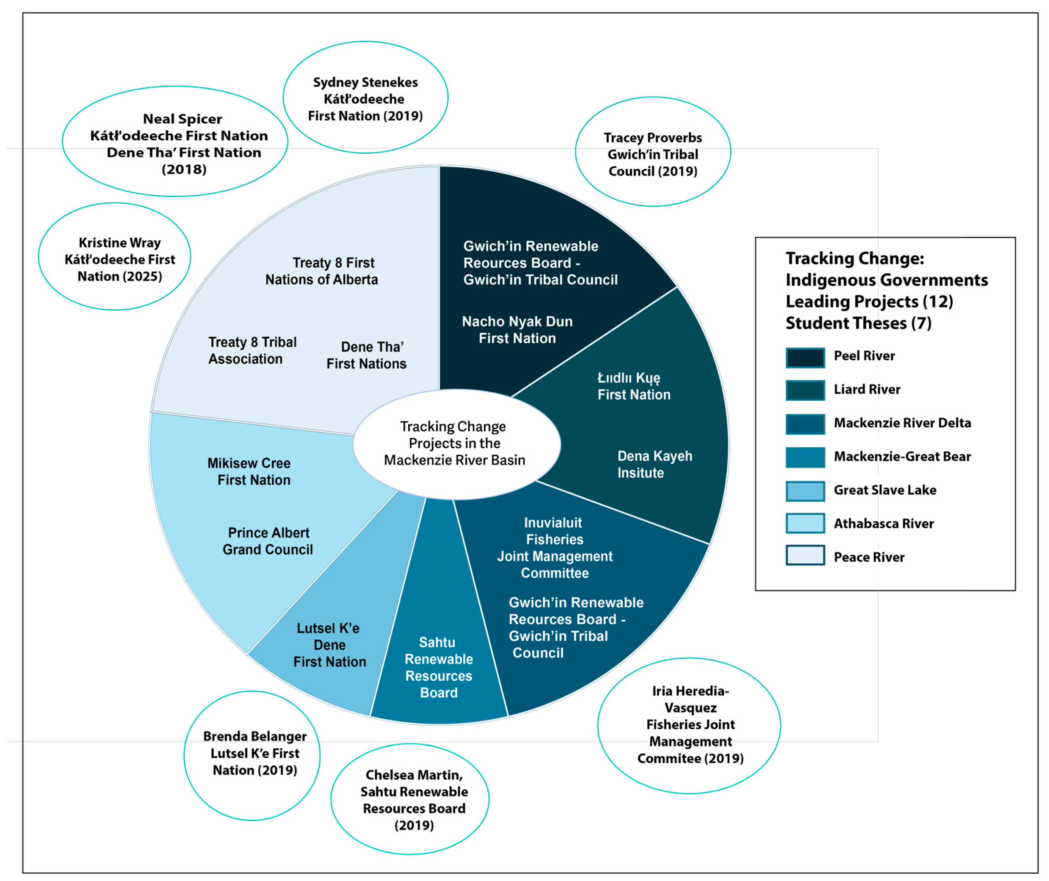
This study synthesizes Indigenous Knowledge of water-level and flow variability across the Mackenzie River Basin (MRB) using a basin-wide qualitative analysis. Reports drawn upon for this paper include submissions from 12 Indigenous governments over a three-year period (Figure 2), resulting in a total of 31 separate projects (not all Indigenous governments completed projects in all three years). The funding additionally enabled a number of academic theses produced through partnerships between Indigenous governments and university researchers, several of which are referenced in the literature review [72,75,86,87,88]. For each project, we used the annual community project reports submitted to Tracking Change, along with the published annual synthesis reports [28,89,90], which compiled a subset of observations from those submissions. Community project reports were produced between 2016 and 2018, and annual synthesis reports were published in 2017 (covering the 2016–17 funding year) and in 2020 (covering 2017–18 and 2018–19). All reports used in this analysis were accessed between 2022 and 2026 through the Tracking Change project. While the annual synthesis reports are publicly available, the underlying community reports are held by Indigenous governments and are not publicly accessible due to Indigenous data governance protocols. A complete list of all reports used is provided in the Supplementary Materials. Inclusion criteria were straightforward: any observation or reflection related to water levels or the social, cultural, or livelihood effects of changing water levels was included. Although the reports were produced between 2016 and 2018, many community reflections describe changes observed over much longer timeframes, with some accounts extending back to the 1990s. These projects were carried out by Indigenous governments and organizations across the Gwich’in, Inuvialuit, Sahtú, Dehcho, Tłı̨chǫ, Dënesųłiné, Cree, and Métis regions, each using their own culturally grounded methods, ethical protocols, and validation processes.
The research was guided by the Traditional Knowledge and Strengthening Partnerships Steering Committee of the Mackenzie River Basin Board (MRBB), which provided direction on research priorities, ethical considerations, and the interpretation of findings [7,20]. Each participating Indigenous government or organization determined its own research questions, data collection methods, and processes for community review, ensuring that the work reflected local priorities and knowledge systems. Data sources included interviews, land-based camps, community workshops, oral histories, participatory mapping, and narrative documentation of travel routes, fishing practices, and seasonal observations. These materials were originally generated for community use, local decision-making, and regional water stewardship, and were later shared for synthesis through the Tracking Change initiative.

3.2. Partnership and Governance

All projects included in this synthesis were conducted under an Agreement for Working Together, which outlined principles of respect, reciprocity, and intellectual property [20,93]. These principles ensured that Indigenous governments retained ownership and control of their knowledge, that community priorities shaped the scope of each project, and that findings were reviewed locally before being shared more broadly. University partners provided logistical support, funding administration, and assistance with synthesis where requested, while deferring to Indigenous leadership in all matters related to knowledge interpretation and use. This collaborative governance model is central to the integrity of the dataset and underpins the basin-wide analysis presented in this paper.

3.3. Analytical Approach

The analysis followed an iterative thematic inquiry approach, adapted for a basin-scale synthesis of Indigenous Knowledge. All available project reports, theses, and documentation were reviewed and coded for themes related to: water-level variability, flow patterns, ice conditions, travel safety, harvesting access, emotional and spiritual impacts, cumulative effects, and hydrological extremes. The review of these materials was carried out by the first author and two graduate students (Carter Goritza and Joanne Speakman). All quotations relating to water levels were identified within the reports and compiled into a spreadsheet, where they were organized by community for comparative analysis. We used iterative thematic coding techniques (e.g., reviewing themes, reviewing quotes, adapting themes) to identify recurring framing (e.g., “it’s drying up”), observations of biophysical changes, and accompanying social reflections, and organized these by region and then by cross-cutting theme [71,94,95]. To ensure cultural and contextual accuracy, coded themes were compared with the original project reports and, where available, community review notes. Themes were then synthesized across regions to identify basin-wide patterns and region-specific concerns, resulting in a set of indicators (Table 2). A workshop involving members of the MRBB led to the validation and refinement of the categories and the addition of further indicators.

3.4. Scope and Limitations

This synthesis reflects the knowledge shared through the Tracking Change initiative and earlier community-based studies. It does not claim to represent all Indigenous Knowledge in the MRB, nor does it replace local knowledge systems or community-specific interpretations of hydrological change. The dataset predates the extreme hydrological events of 2020–2023; however, these events are referenced where communities have since reflected on them in relation to earlier observations.
The purpose of this analysis is not to standardize Indigenous Knowledge but to highlight the social dimensions of hydrological variability and the cumulative patterns that emerge across the Basin. Indigenous Knowledge is inherently place-based, relational, and grounded in lived experience, and therefore cannot be reduced to a single set of indicators or generalized interpretations. Instead, this synthesis aims to respect the diversity of regional perspectives while identifying shared concerns that can inform basin-wide water governance and community resilience.

4. Results

There are multiple insights that emerged from Indigenous-led and collaborative projects supported through the Tracking Change project. Among these are insights about the biophysical aspects of hydrological change (e.g., decreasing water levels and flow) that were observed or experienced by participants involved in the Tracking Change projects. These insights are not presented as biophysical data alone but are knitted together with related experiences of travel, harvesting or other socio-cultural practices.

4.1. Indicators of Hydrological Change

Across the MRB, Indigenous Knowledge holders described a consistent set of indicators used to assess and communicate hydrological change. These indicators reflect both biophysical observations and the social, cultural, and emotional dimensions of water-level change. Table 2 summarizes the most commonly reported indicators across the Basin. Across regions, people used similar signs and signals to interpret water-level change, many of which have been observed for decades.
These indicators have been documented across the Peace River sub-basin, the Athabasca and Slave River Deltas, Great Slave Lake, the Dehcho region, and the Gwich’in region since at least the 1990s. They remain central to how land users interpret changing water conditions.

4.2. Cross-Basin Patterns of Hydrological Change

4.2.1. Declining Water Levels and Changing Flow

Across the MRB, participants described widespread declines in water levels. In the Inuvialuit region, people observed “a lot less water and it is a lot shallower” (Fisheries Joint Management Committee, Aklavik, William Storr; Community Report, 2017–2018, p. 10); and noted “the drying up of creeks” in the Mackenzie Delta (Fisheries Joint Management Committee) [90] (p. 19). These changes were accompanied by increasingly unpredictable flooding:
We never used to see high water like in the fall our fluctuating level in the fall. You know now sometimes we’ll have high water where it shouldn’t be high, or it should be low. This year, you know, with all the rain, there was so much rain, so there was flooding.
(Fisheries Joint Management Committee, Allen Kogiak, Community Report, 2017–2018, p. 10)
Lower water levels were also reported in the Sahtú region, where Great Bear Lake and nearby lakes were described as “a little bit lower than before… about a foot” (Sahtú Renewable Resources Board, Community Report, 2017–2018, p. 9). In the Slave River region, an Elder reflected on long-term decline:
[It is now] really low, way lower than before. Bennett Dam or something is taking our water. When I was a kid, the water was always swift, it went down 8 feet since I was a kid, and I’m 70 now. No water will be left for our grandkids if it keeps going down like that.
(Akaitcho Territory Government, Deninu Kųę/Fort Resolution) [90] (p. 58)
Similar concerns were raised on the east side of Great Slave Lake, where “the whole [Artillery] Lake [water level] has gone down. About five feet, I’d say. And that’s probably been within the last ten to fourteen years, something like that. I noticed, we started getting longer summers” (Łutsël K’e Dene First Nation, Ron Fatt) [90] (p. 51). Participants linked these changes to climate change, altered precipitation, and upstream regulation. As the quote above notes, “Bennett Dam… is taking our water” (Akaitcho Territory Government, Deninu Kųę/Fort Resolution) [90] (p. 58). Others emphasized cumulative effects: “The most pervasive problems facing the Mikisew is the change to water quantity. The combined pressures of hydroelectric development, water withdrawals for Tar Sands development and climate change has reduced the amount of water reaching the Peace Athabasca Delta” (Mikisew Cree First Nation) [90] (p. 42).
Fluctuations were also noted. In the Peace River sub-basin, people described water levels that “fluctuate more and are more unpredictable than in the past. ‘100 year’ floods and droughts become a regular occurrence” (Treaty 8 First Nations of Alberta, Dene Tha’ First Nations), [28] (p. 40). These fluctuations were often attributed to flow regulation from the W.A.C. Bennett Dam.

4.2.2. Geomorpholgical Change—Erosion, Sedimentation and Sandbars

Communities across the Basin described significant geomorphological changes. In the Mackenzie Delta, participants observed that “they’re quite a bit different […] A lot less water. Shallower […] A lot more, a lot of the banks have eroded. They’ve kinda, there are some of them rivers gotten wider but they’re shallower” (Fisheries Joint Management Council, Aklavik, William Storr) [89] (p. 14). Sandbars were a major concern: “In the fifties, sixties and seventies, even big boats used to go back and forth; now they can’t even, the rivers are no longer rivers and a lot of sandbars” (Fisheries Joint Management Committee, Aklavik, Renie Arey, Community Report, 2017–2018, p. 10). Another community member notes that “you can pretty well get around those sandbars and sometimes just other ways around but places you can’t get to. Like Running River they don’t, they can’t use their camps there anymore” (Fisheries Joint Management Committee, Aklavik, Johnny Storr) [89] (p. 14). Similar observations were shared in the Gwich’in Settlement Area and Sahtú region, where people noted “the water, the river really, really less water all, all over. There are sandbars all over” (Gwich’in Renewable Resources Board, Abe Stewart, Tetłit Zheh, Community Report, 2017–2018, p. 8) and that “some of them get shallow. Just like this bay down here. Just down below the ferry. Really shallow. People used to fish there. Maybe some come to the ferry I guess” (Gwich’in Renewable Resources Board, Tsiigehtchic, Frederick Blake, Community Report, 2017–2018, p. 8).
Sedimentation patterns were also shifting. In the Slave River Delta, participants described “less sediment coming out from the Slave River,” (Mike Low, Interview) [88], affecting fish habitat and lake ecology. Residents noted that oxbow lakes and sloughs were “being cleaned out” and that “you’re not getting the heavy sedimentation into the basin” (Lloyd Jones, Interview) [88].

4.2.3. Warming Water and Changing Ice Regimes

Participants across regions observed warming water temperatures. A commercial fisherman noted, “The waters of the lake are warmer” (Commercial Fisherman, Interview, Hay River) [88], while others described fish responding to these changes: “The lakes are starting to warm up… which isn’t good” (Kátł’odeeche First Nation, Peter Sabourin, Interview) [88].
Ice conditions were also changing. In the Dehcho and Akaitcho regions, people described a shorter ice-coverage season, with “air pockets under [the ice]” and thinner ice than in the past. These changes were linked to increased travel risks and reduced time for hunting, trapping, and harvesting. There is a shorter ice-coverage season, which is a cause for travel concerns, limiting the amount of time for spring and fall hunting and altering the trapping season for many.
The ice was always solid before, now there are air pockets under them and it’s much thinner than it used to be. [This has] implications on community members that travel on the land and water, this combined with lower water levels causing more reefs and sandbars to rise is not only making travel more difficult, but more dangerous.
(Akaitcho Territory Government, Deninu Kųę/Fort Resolution, Community Report, 2016–2017, p. 5)

4.3. Social, Cultural, and Livelihood Impacts

4.3.1. Travel Safety and Mobility

Lower water levels and shifting channels are increasingly observed across the Basin. In the Slave River region, “travelers on the lake are seeing more reefs, making travel dangerous” (Akaitcho Territory Government, Deninu Kųę/Fort Resolution) [90] (p. 57). In the Kátł’odeeche region, people reported being unable to reach key areas.
So when we try and go up [Buffalo River], you know we have to do it either by plane or boat or a jet boat up the river and we just haven’t been able to time it due to low water levels over the last few years. Particularly, the water levels on the [Buffalo] river have been low. And in one case, the ice formed early so it was kind of tough to, you know to get out there at the time.
(Kátł’odeeche First Nation, Peter Redvers, Interview) [88]
Commercial fishers described increased hazards:
Water levels are low—for commercial fishing, sometimes you haven’t been to a spot, and then—or you’ve been to a spot before, and then the water levels go down, and then sometimes you hit a big rock, or whatever. So, there are a lot of changes in that. The water level sometimes goes down, and you have to be more careful nowadays than before.
(Kátł’odeeche First Nation, Peter Sabourin, Inter-view) [88]

4.3.2. Access to Camps, Fishing Areas, and Cultural Sites

Hydrological change has reduced access to important cultural and harvesting areas. In the Mackenzie Delta, participants noted “places you can’t get to… they can’t use their camps there anymore” (Inuvialuit Fisheries Joint Management Committee, Aklavik, Johnny Storr), [28] (p. 14). In the Peace-Athabasca Delta, Mikisew Cree First Nation described a widespread “convergence” of declining passage and “accelerated drop in access across the southern part of the delta”.
Convergence occurs in loss of use… there is widespread convergence of declining passage such that there is an accelerated drop in access across the southern part of the delta in association with that threshold. This represents a loss in use over a significant extent of our territories.
(Mikisew Cree First Nation) [90] (p. 72)
In the Łutsël K’e region, Elders described needing to “put branches down… to get to the lake,” reflecting significant shoreline recession.
Of course, there’s less water, just about all over the place, the whole country that I travel in is different, there’s no water. Inland lakes, sometimes you have to put branches down, make a trail to get to the lake, it’s not like before.
(Akaitcho Territory Government, Łutsël K’e Dene First Nation, Community Report, 2016–2017, p. 3)

4.3.3. Impacts on Fishing and Food Security

Hydrological change has affected fish movement, habitat, and harvesting practices. In the Peace River tributaries, low water levels “affect fish spawning grounds” (Treaty 8 First Nations of Alberta, Dene Tha’ First Nations) [28] (p. 40). In the Gwich’in region, people observed that “the fish is getting soft,” linking this to warmer water and emerging sandbars.
We noticed some sand bars are starting to show up that we’ve never seen before. Even down here ah, sand bars starting to show up in the river and the fish is getting soft too. Never see sand bars coming up like that around here.
(Gwich’in Renewable Resources Board, Lorraine Francis, Tetłit Zheh/Fort McPherson, Community Report, 2017–2018, p. 8)
Beaver population expansion was also a major concern in the Inuvialuit region. “And then we had the beaver just overpopulate everything” (Fisheries Joint Management Committee, Aklavik, Cheryl Arey, Community Report 2017–2018, p. 7–8). Participants described waterways being blocked, affecting fish movement and access to camps (Fisheries Joint Management Committee, Community Report, 2016–2017).

4.3.4. Drinking Water and Water Quality

Concerns about water potability were widespread. In the Inuvialuit region, people described hauling water because local sources were no longer safe: “We haven’t drunk any water from up at that camp, up at our camp for probably 15 years. We’ve been, we haul our water from here” (Fisheries Joint Management Committee, Aklavik, Cheryl Arey, Community Report 2017–2018, p. 7–8). In the Akaitcho region, Elders warned that water would not always be abundant. “Elders told stories about the people in the future having to walk way out into the middle of the lake, just to get water” (Deninu Kųę First Nation, Akaitcho Tribal Government, Community Report 2017–2018, p. 4).

5. Discussion

This basin-wide synthesis of Indigenous Knowledge reveals that hydrological change in the Mackenzie River Basin (MRB) is experienced not only as a biophysical phenomenon, but also as a deeply social, cultural, and emotional process. While scientific assessments document shifts in discharge, snowmelt timing, permafrost thaw, and ice dynamics [1,7,14,24], Indigenous Knowledge highlights how these changes shape daily life—altering travel routes, limiting access to harvesting areas, disrupting cultural responsibilities, and affecting wellbeing [13,72]. These insights underscore the need to understand hydrological variability as a social-ecological issue, rather than a strictly environmental one.
Across regions, community members describe water levels and flow patterns as increasingly unpredictable. Low-water periods expose new hazards, lengthen travel times, and restrict access to places central to family life and cultural continuity [6,8,73]. High-water events, including recent extreme floods, are experienced as both physical danger and emotional trauma, affecting mobility, safety, and the ability to maintain relationships with culturally significant places. These observations align with scientific projections of more volatile hydrological regimes under climate change [1,7,9], yet they also extend beyond scientific metrics by illuminating the lived consequences of these shifts.
Participants consistently distinguished between short-term weather events and longer-term structural changes in the river system. Extreme events such as single-year floods, sudden drops in water level, or unusually heavy rainfall were described as acute disruptions that affected travel and safety in the moment. In contrast, observations of persistent low water, earlier and faster spring breakup, channel narrowing, and ongoing riverbank recession were framed as long-term changes that have unfolded over decades. These longer-term patterns were often linked by community members to broader climatic shifts, including warmer winters, reduced snowpack, and the cumulative effects of permafrost thaw. This distinction between episodic events and sustained hydrological change aligns with scientific evidence of long-term warming trends in the MRB [2,3,7], while also highlighting how communities interpret and experience these processes differently from short-term weather variability.
A key finding of this study is the consistency of concerns across diverse sub-basins. Although each region has its own hydrological characteristics, communities repeatedly emphasize similar themes: difficulty navigating shallower channels, loss of safe travel routes, changes in fish movement and habitat, emotional and spiritual impacts of being unable to reach important places, and cumulative stress associated with unpredictable water conditions. These shared experiences suggest that hydrological change is producing basin-wide cumulative effects that become visible only when observations are synthesized across regions.
Another important contribution of this study is the synthesis of Indigenous Knowledge with hydrological science. Community observations of earlier breakup, prolonged low-water periods, shoreline slumping, and shifting sandbars correspond with scientific evidence of warming temperatures, altered snowmelt timing, and permafrost degradation [1,2,7,29,30]. At the same time, Indigenous Knowledge provides insight into aspects of hydrological change that are difficult to capture through conventional monitoring, such as: the cultural significance of water-level variability, the emotional impacts of extreme events, the role of water in teaching and intergenerational knowledge transmission, and the ways hydrological change affects Treaty rights and land-based practices [10,11,12,13,20].
Taken together, these insights point to the need for governance approaches that can respond to both the biophysical and social dimensions of hydrological change. Current monitoring frameworks tend to emphasize biophysical indicators for cumulative-effects assessment and regulatory decision-making [16,17]. Yet the social dimensions of hydrological change—mobility, safety, cultural continuity, and wellbeing—are central to community resilience and the exercise of Indigenous rights. Incorporating Indigenous Knowledge into basin-wide assessments can help identify thresholds of concern, improve early warning systems, and support decision-making that reflects community priorities [15,24,25].
Practical mechanisms already exist in the Mackenzie River Basin that demonstrate how Indigenous Knowledge can enhance more responsive and culturally grounded water governance. For example, the Aboriginal Base Flow—which identifies the minimum water level needed for safe travel and harvesting—and the Aboriginal Extreme Flow—which identifies the high-water conditions that create danger or damage—are indicators developed by the Mikisew Cree and Athabasca Chipewyan First Nations that provide Indigenous-defined hydrological thresholds to inform regulatory decisions about industrial water withdrawals [20,67,73]. These indicators translate lived experience and cultural relationships with water into operational criteria that complement scientific monitoring. Similarly, existing co-management structures in the Northwest Territories—such as regional land and water boards—offer institutional pathways for integrating community observations into decision-making through established protocols for data sharing, annual reporting, and joint review processes [15,25].
The results also highlight the importance of Indigenous-led research and governance structures that uphold Indigenous laws, responsibilities, and relationships with water. These approaches offer models for integrating cultural values and lived experience into water-management frameworks and for ensuring that decision-making reflects community priorities and rights.
Overall, this study demonstrates that hydrological change in the MRB cannot be understood solely through scientific metrics. A more holistic approach—one that integrates Indigenous Knowledge, recognizes the social and cultural dimensions of water, and attends to cumulative effects across regions—is essential for supporting adaptive and equitable water governance in a rapidly changing climate.

6. Conclusions

Hydrological change in the Mackenzie River Basin (MRB) is reshaping the relationships that Indigenous Peoples maintain with rivers, lakes, and wetlands. This synthesis demonstrates that water-level and flow variability affect far more than physical access or environmental conditions—they influence safety, livelihoods, cultural continuity, and emotional and spiritual wellbeing [10,11,12,13]. By bringing together Indigenous Knowledge from across the Basin, this study highlights basin-wide patterns that are not visible through localized studies alone and provides new insight into the cumulative social-ecological impacts of freshwater change.
The findings underscore the value of Indigenous Knowledge for understanding hydrological variability in a rapidly changing climate. Community observations offer detailed, place-based insight into seasonal timing, river behaviour, ice conditions, and landscape transformations [6,8,18,26], while also illuminating the cultural and emotional dimensions of water-level change that are not captured through conventional monitoring [15,16,17]. These perspectives complement scientific assessments of changing snowmelt dynamics, permafrost thaw, and altered flow regimes [1,2,7,14], pointing to the need for monitoring and governance approaches that reflect the full complexity of freshwater systems.
As extreme events become more frequent and hydrological conditions more unpredictable, supporting Indigenous-led research and governance will be essential for building resilience in the MRB. Indigenous governments are already developing innovative approaches—such as the Aboriginal Base Flow (ABF) and Aboriginal Extreme Flow (AXF) indicators—that integrate cultural values, lived experience, and hydrological thresholds [20]. Strengthening relationships between Indigenous Knowledge systems and hydrological science can contribute to more responsive, culturally grounded, and community-centered water stewardship.
By centering the lived experiences of hydrological change, this study offers a foundation for future work that seeks to understand and respond to the social-ecological transformations unfolding across the Basin. The results highlight the importance of governance frameworks that uphold Indigenous laws and responsibilities for water, recognize the social dimensions of hydrological variability, and support adaptive decision-making in a time of accelerating environmental change.

Supplementary Materials

The following supporting information can be downloaded at https://www.mdpi.com/article/10.3390/w18131642/s1. File S1: List of Annual and Indigenous-led Project Reports (2016–2018).

Author Contributions

Conceptualization: MRBB Traditional Knowledge and Strengthening Partnerships Committee, B.P. and K.W.; methodology, B.P. and K.W.; validation, K.W., B.P. and MRBB Traditional Knowledge and Strengthening Partnerships Committee; formal analysis, K.W. and B.P.; investigation, K.W.; data curation, B.P., K.W., T.H., MRBB Traditional Knowledge and Strengthening Partnerships Committee; writing—original draft preparation, K.W.; writing—review and editing, K.W., B.P., MRBB Traditional Knowledge and Strengthening Partnerships Committee, T.H.; visualization, K.W. and B.P.; supervision, B.P.; project administration, B.P., T.H. and K.W.; funding acquisition, B.P. and K.W. All authors have read and agreed to the published version of the manuscript.

Funding

This research was funded by the Social Science and Humanities Research Council of Canada (SSHRCC) (895-2015-1024; 752-2018-1403); the Aboriginal Steering Committee of the Northwest Territories Water Stewardship Strategy (Government of the Northwest Territories), UAlberta North, Northern Scientific Training Program, Canadian Mountain Network, the Government of Alberta, the University of Alberta, and by in-kind contributions to projects led by Indigenous partners. Finally, we acknowledge the support of the Government of Canada’s New Frontiers in Research Fund (NFRF), [NFRFT-2020-00188].

Institutional Review Board Statement

The study was conducted in accordance with the Declaration of Helsinki, and the protocol was approved by the Research Ethics Board of the University of Alberta (Research Study Number #Pro00091857 on 19 September 2019, and #Pro00094722), and by the Aurora Research Institute, Scientific Research License No. 16630 on 21 October 2019 and License No. 16160 on 24 August 2016.

Informed Consent Statement

Informed consent for participation was obtained from all subjects involved in the study.

Data Availability Statement

The qualitative data used in this study were generated through Indigenous-led research conducted within the Tracking Change program and governed by an “Agreement for Working Together” developed with the Tracking Change Steering Committee. This agreement outlines shared understandings, roles, and principles, including respect for the intellectual property rights of participating individuals and Indigenous governments. Data cited in this article include (1) publicly available Tracking Change annual reports (2016–2018) available at https://trackingchange.ca/ and (2) annual community project reports that are not publicly accessible due to community governance protocols and confidentiality agreements. Access to non-public materials requires permission from the relevant Indigenous partners and governing bodies.

Acknowledgments

The authors acknowledge the contributions and support of the following people, Indigenous governments and communities: Carter Gortiza, Joanne Speakman, Kátł’odeeche First Nation, Akaitcho Territory Government, Deninu Kųę First Nation, Gwich’in Renewable Resources Board, Inuvialuit Joint Secretariat—Fisheries Joint Management Committee, Łutsël K’e Dene First Nation, Mikisew Cree First Nation, The First Nation of Na Cho Nyäk Dun, Prince Albert Grand Council, Treaty 8 First Nations of Alberta, Treaty 8 First Nations of British Columbia, Wek’èezhÌı Renewable Resources Board, Xehdzo Got’ine Gots’e Nakedi/Sahtú Renewable Resources Board. During the preparation of this manuscript, the authors used Microsoft Copilot (accessed May 2026) for grammar refinement, formatting, and non-substantive editing of author-written text. The tool was not used to generate, interpret, or modify Indigenous Knowledge, community-shared insights, or direct quotations. The authors have reviewed and edited all AI-assisted output and take full responsibility for the content of this publication.

Conflicts of Interest

The authors declare no conflicts of interest. The funders had no role in the design of the study; in the collection, analyses, or interpretation of data; in the writing of the manuscript; or in the decision to publish the results.

Abbreviations

The following abbreviations are used in this manuscript:
MRBMackenzie River Basin
MRBBMackenzie River Basin Board

References

  1. Mackenzie River Basin Board—MRRB. The Mackenzie River Basin Board’s 2012 Issues Report; Mackenzie River Basin Board Secretariat: Fort Smith, NT, Canada, 2012. [Google Scholar]
  2. Stewart, R.E.; Crawford, R.W.; Leighton, H.G.; Marsh, P.; Strong, G.S.; Moore, G.W.K.; Ritchie, H.; Rouse, W.R.; Soulis, E.D.; Kochtubajda, B. The Mackenzie GEWEX Study: The Water and Energy Cycles of a Major North American River Basin. Bull. Amer. Meteor. Soc. 1998, 79, 2665–2683. [Google Scholar] [CrossRef]
  3. Walvoord, M.A.; Kurylyk, B.L. Hydrologic Impacts of Thawing Permafrost—A Review. Vadose Zone J. 2016, 15, 1–13. [Google Scholar] [CrossRef]
  4. Wrona, F.J.; Prowse, T.D.; Reist, J.D.; Beamish, R.; Gibson, J.J.; Hobbie, J.; Jeppesen, E.; King, J.; Koeck, G.; Korhola, A. Freshwater Ecosystems and Fisheries. In ACIA. Arctic Climate Impact Assessment; Cambridge University Press: Cambridge, UK, 2005; pp. 353–452. [Google Scholar]
  5. Shi, J.X.; Xu, J.; Yang, D. Attribution of Hydrological Trends and Change Points in the Discharge of Mackenzie River during 1972–2020. In Proceedings of the EGU General Assembly 2024, Vienna, Austria, 14–19 April 2024; p. 13114. [Google Scholar]
  6. Alunik, I.; Kolausok, E.; Morrison, D. Across Time and Tundra: The Inuvialuit of the Western Arctic; University of Washington Press: Seattle, WA, USA, 2003. [Google Scholar]
  7. Mackenzie River Basin Board. State of the Aquatic Ecosystem Report for the Mackenzie River Watershed; Mackenzie River Basin Board: Edmonton, AB, Canada, 2024. [Google Scholar]
  8. Thompson, A.; Millar, N. Traditional Knowledge of Fish Migration and Spawning Patterns in Tsiigehnjik (Arctic Red River) and Nagwichoonjik (Mackenzie River), Northwest Territories; GRRB Report 07-02; Gwich’in Renewable Resoruces Board: Inuvik, NT, Canada, 2007. [Google Scholar]
  9. Woo, M.; Thorne, R. Summer Low Flow Events in the Mackenzie River System. Arctic 2016, 69, 286–304. [Google Scholar] [CrossRef]
  10. Baird, I.G.; Manorom, K.; Phenow, A.; Gaja-Svasti, S. Opening the Gates of the Pak Mun Dam: Fish Migrations, Domestic Water Supply, Irrigation Projects and Politics. Water Altern. 2020, 13, 141–159. [Google Scholar]
  11. Bill, L.; Crozier, J. A Report of Wisdom Synthesized from the Traditional Knowledge Component Studies/Prepared for: Northern River Basins Study; Government of Canada, Northern River Basin Study: Ottawa, ON, Canada, 1996.
  12. Castleden, H. Connecting Community-Based Water Monitoring with Environmental Management and Stewardship in Canada; Queen’s University: Kingston, ON, Canada, 2015. [Google Scholar]
  13. Ziegler, J.A.; Lantz, T.C.; Overeem, T.; Proverbs, T.A.; Lord, S.; Aklavik Hunters and Trappers Committee; Gwich’in Tribal Council Department of Culture and Heritage; Inuvik Hunters and Trappers Committee. “All the Rivers We Used to Travel by”: Indigenous Knowledge of Hydrological Change and Its Impacts in the Mackenzie Delta Region, Canada. Reg. Environ. Change 2024, 24, 66. [Google Scholar] [CrossRef]
  14. Yip, Q.K.Y.K.Y.; Burn, D.H.H.; Seglenieks, F.; Pietroniro, A.; Soulis, E.D.D. Climate Impacts on Hydrological Variables in the Mackenzie River Basin. Can. Water Resour. J. Rev. Can. Des. Ressour. Hydr. 2012, 37, 209–230. [Google Scholar] [CrossRef]
  15. Davidson, S.L.; de Loë, R.C. Watershed Governance: Transcending Boundaries. Water Altern. 2014, 7, 367–387. [Google Scholar]
  16. Gummer, W.D.; Conly, F.M.; Wrona, F.J. Northern Rivers Ecosystem Initiative: Context and Prevailing Legacy. Environ. Monit. Assess. 2006, 113, 71–85. [Google Scholar] [CrossRef] [PubMed]
  17. Wong, L.; Noble, B.; Hanna, K. Water Quality Monitoring to Support Cumulative Effects Assessment and Decision Making in the Mackenzie Valley, Northwest Territories, Canada. Integr. Environ. Assess. Manag. 2019, 15, 988–999. [Google Scholar] [CrossRef] [PubMed]
  18. Andrews, T. Rakekee Gok’e Godi: Places We Take Care of: Report of the Sahtu Heritage Places and Sites Joint Working Group; Prince of Wales Northern Heritage Centre: Yellowknife, NT, Canada, 2000. [Google Scholar]
  19. Andrews, T.D.; Buggey, S. Canadian Aboriginal Cultural Landscapes in Praxis. In Managing Cultural Landscapes; Taylor, K., Lennon, J.L., Eds.; Routledge: Abingdon, UK, 2012; pp. 253–271. [Google Scholar]
  20. Parlee, B.; Huntington, H.; Berkes, F.; Lantz, T.; Andrew, L.; Tsannie, J.; Reece, C.; Porter, C.; Nicholson, V.; Peter, S. One-Size Does Not Fit All—A Networked Approach to Community-Based Monitoring in Large River Basins. Sustainability 2021, 13, 7400. [Google Scholar] [CrossRef]
  21. Hanks, C.C.; Winter, B.J. The Traditional Fishery on Deh Cho: An Ethnohistoric and Archaeological Perspective. Arctic 1991, 44, 47–56. [Google Scholar] [CrossRef]
  22. Helm, J. The People of Denendeh: Ethnohistory of the Indians of Canada’s Northwest Territories; McGill-Queen’s University Press: Montreal, QC, Canada, 2000. [Google Scholar]
  23. Shimeall, C. Doings with Land: Process and Participation through Indigenous-Led, Experiential Education in Saqáanpa (the Snake River in Hells Canyon). Bachelor’s Thesis, Portland State University, Portland, OR, USA, 2023. [Google Scholar]
  24. Mackenzie River Basin Board—MRRB. State of the Aquatic Ecosystem Report; Mackenzie River Basin Board Secretariat: Fort Smith, NT, Canada, 2003. [Google Scholar]
  25. Parsons, M.; Fisher, K. Indigenous Peoples and Transformations in Freshwater Governance and Management. Curr. Opin. Environ. Sustain. 2020, 44, 124–139. [Google Scholar] [CrossRef]
  26. Legat, A. Habitat of Dogrib Traditional Territory: Place Names as Indicators of Biogeographical Knowledge; Tłiıchǫ Traditional Knowledge Reports: Series 2; Tłiıchǫ Research and Training Institute: Yellowknife, NT, Canada, 2014. [Google Scholar]
  27. McGregor, D.; Sritharan, M.; Whitaker, S. Indigenous Peoples, Sustainable Development, and Ontologies of Water. In Routledge Handbook of Water and Development; Routledge: Abingdon, UK, 2023; pp. 71–84. [Google Scholar]
  28. Maloney, E.; Howlett, T.; Parlee, B. Tracking Change Local and Traditional Knowledge in Watershed Governance. Report of the 2018–2019 Community-Based Research Projects in the Mackenzie River Basin; University of Alberta: Edmonton, AB, Canada, 2020. [Google Scholar]
  29. Kokelj, S.V.; Lantz, T.C.; Solomon, S.; Pisaric, M.F.; Keith, D.; Morse, P.; Thienpont, J.R.; Smol, J.P.; Esagok, D. Using Multiple Sources of Knowledge to Investigate Northern Environmental Change: Regional Ecological Impacts of a Storm Surge in the Outer Mackenzie Delta, NWT. Arctic 2012, 65, 257–272. [Google Scholar] [CrossRef]
  30. Mohseni Saravi, M.; Abasizadeh, M.; Malekian, A.; Nazari Samani, A.A. The Relationship between Morphoclimatic Characteristics and Peak Flows: A Case Study of the Southern Alborz Basins, Iran. Prog. Phys. Geogr. 2010, 34, 173–182. [Google Scholar] [CrossRef]
  31. Wilson, N.J. “Seeing Water Like a State?”: Indigenous Water Governance through Yukon First Nation Self-Government Agreements. Geoforum 2019, 104, 101–113. [Google Scholar] [CrossRef]
  32. Beltaos, S. Hydrodynamic and Climatic Drivers of Ice Breakup in the Lower Mackenzie River. Cold Reg. Sci. Technol. 2013, 95, 39–52. [Google Scholar] [CrossRef]
  33. de Rham, L.P.; Prowse, T.D.; Beltaos, S.; Lacroix, M.P. Assessment of Annual High-water Events for the Mackenzie River Basin, Canada. Hydrol. Process. Int. J. 2008, 22, 3864–3880. [Google Scholar]
  34. de Rham, L.P.; Prowse, T.D.; Bonsal, B.R. Temporal Variations in River-Ice Break-up over the Mackenzie River Basin, Canada. J. Hydrol. 2008, 349, 441–454. [Google Scholar] [CrossRef]
  35. Legat, A. Walking the Land, Feeding the Fire A Tłįchô Ethnography on Becoming Knowledgeable; The University of Arizona Press: Tucson, AZ, USA, 2012. [Google Scholar]
  36. Schindler, D.W.; Donahue, W.F. An Impending Water Crisis in Canada’s Western Prairie Provinces. Proc. Natl. Acad. Sci. USA 2006, 103, 7210–7216. [Google Scholar] [CrossRef] [PubMed]
  37. Timoney, K.P.; Lee, P. Does the Alberta Tar Sands Industry Pollute? The Scientific Evidence. Open Conserv. Biol. J. 2009, 3. [Google Scholar] [CrossRef]
  38. Berkes, F. Sacred Ecology; Routledge: New York, NY, USA; Routledge: London, UK, 2017. [Google Scholar]
  39. Leonard, K.; David-Chavez, D.; Smiles, D.; Jennings, L.; Alegado, R.A.; Tsinnajinnie, L.; Manitowabi, J.; Arsenault, R.; Begay, R.L.; Kagawa-Viviani, A. Water Back: A Review Centering Rematriation and Indigenous Water Research Sovereignty. Water Altern. 2023, 16, 374–428. [Google Scholar]
  40. Davidson, A.; Mehlhorn, A. Deepening Sense of Place and Water Literacy of the Mohawk River Watershed through Art, Science, and Indigenous Knowledge. In Proceedings of the 2025 Mohawk Watershed Symposium, Union College, Schenectady, NY, USA, 21 March 2025. [Google Scholar]
  41. McEwen, L.; Roberts, L.; Holmes, A.; Blake, J.; Liguori, A.; Taylor, T. Building Local Capacity for Managing Environmental Risk: A Transferable Framework for Participatory, Place-Based, Narrative-Science Knowledge Exchange. Sustain. Sci. 2022, 17, 2489–2511. [Google Scholar]
  42. Ungunmerr-Baumann, M.-R.; Groom, R.A.; Schuberg, E.L.; Atkinson, J.; Atkinson, C.; Wallace, R.; Morris, G. Dadirri: An Indigenous Place-Based Research Methodology. Altern. Int. J. Indig. Peoples 2022, 18, 94–103. [Google Scholar] [CrossRef]
  43. Wooltorton, S.; Collard, L.; Horwitz, P.; Poelina, A.; Palmer, D. Sharing a Place-Based Indigenous Methodology and Learnings. Environ. Educ. Res. 2020, 26, 917–934. [Google Scholar] [CrossRef]
  44. Zurba, M.; Maclean, K.; Woodward, E.; Islam, D. Amplifying Indigenous Community Participation in Place-Based Research through Boundary Work. Prog. Hum. Geogr. 2019, 43, 1020–1043. [Google Scholar]
  45. Finn, M.; Jackson, S. Protecting Indigenous Values in Water Management: A Challenge to Conventional Environmental Flow Assessments. Ecosystems 2011, 14, 1232–1248. [Google Scholar] [CrossRef]
  46. Jackson, S.; Storrs, M.; Morrison, J. Recognition of Aboriginal Rights, Interests and Values in River Research and Management: Perspectives from Northern Australia. Ecol. Manag. Restor. 2005, 6, 105–110. [Google Scholar] [CrossRef]
  47. LaPensée, E.; Emmons, N. Indigenizing Education with the Game “When Rivers Were Trails”. Am. Am. Stud. 2019, 64, 75–93. [Google Scholar] [CrossRef]
  48. Twance, M. Learning from Land and Water: Exploring Mazinaabikiniganan as Indigenous Epistemology. Environ. Educ. Res. 2019, 25, 1319–1333. [Google Scholar] [CrossRef]
  49. Fox, C.A.; Reo, N.J.; Turner, D.A.; Cook, J.; Dituri, F.; Fessell, B.; Jenkins, J.; Johnson, A.; Rakena, T.M.; Riley, C. “The River Is Us; the River Is in Our Veins”: Re-Defining River Restoration in Three Indigenous Communities. Sustain. Sci. 2017, 12, 521–533. [Google Scholar] [CrossRef]
  50. Kimmerer, R. Restoration and Reciprocity: The Contributions of Traditional Ecological Knowledge. In Human Dimensions of Ecological Restoration: Integrating Science, Nature, and Culture; Springer: Berlin/Heidelberg, Germany, 2011; pp. 257–276. [Google Scholar]
  51. Senos, R.; Lake, F.K.; Turner, N.; Martinez, D. Traditional Ecological Knowledge and Restoration Practice. In Restoring the Pacific Northwest: The Art and Science of Ecological Restoration in Cascadia; Apostol, D., Sinclair, M., Eds.; Island Press: Washington, DC, USA, 2006; Chapter 17; pp. 393–426. [Google Scholar]
  52. Diver, S.; Eitzel, M.; Fricke, S.; Hillman, L. Networked Sovereignty: Polycentric Water Governance and Indigenous Self-Determination in the Klamath Basin. Water Altern. 2022, 15, 523–550. [Google Scholar]
  53. Finlayson, C. A River Is Born: New Zealand Confers Legal Personhood on the Whanganui River to Protect It and Its Native People. In Sustainability and the Rights of Nature in Practice; CRC Press: Boca Raton, FL, USA, 2019; pp. 259–278. [Google Scholar]
  54. Jackson, S. Water and Indigenous Rights: Mechanisms and Pathways of Recognition, Representation, and Redistribution. Wiley Interdiscip. Rev. Water 2018, 5, e1314. [Google Scholar] [CrossRef]
  55. Jones, C. New Treaty, New Tradition: Reconciling New Zealand and Maori Law; UBC Press: Vancouver, BC, Canada, 2016. [Google Scholar]
  56. Robison, J.; Cosens, B.; Jackson, S.; Leonard, K.; McCool, D. Indigenous Water Justice. Lewis Clark L. Rev. 2018, 22, 841. [Google Scholar]
  57. Tootonsab, Z. An Ethical (s) Pace/Water Is Life Project: Restoring the Athabasca River Ecosystem through Indigenous Self-Determination. ESC Engl. Stud. Can. 2021, 47, 109–118. [Google Scholar]
  58. Assunção, A.M.; da Silva, A.S.; da Silva, H.B.; Juruna, J.J.P.; Nunes, J.A.; Kleme, M.S.S.; Ferreira, P.P.; da Silva Juruna, R.T.V.; dos Santos, R.S.; Lima, S.R. Voices of the Xingu: Community-Based Monitoring Reveals the Impacts of the Permanent Drought Imposed to an Amazonian River by the Belo Monte Hydroelectric Power Plant. Res. Sq. 2024. [Google Scholar] [CrossRef] [PubMed]
  59. Baird, I.G.; Silvano, R.A.M.; Parlee, B.; Poesch, M.; Maclean, B.; Napoleon, A.; Lepine, M.; Hallwass, G. The Downstream Impacts of Hydropower Dams and Indigenous and Local Knowledge: Examples from the Peace–Athabasca, Mekong, and Amazon. Environ. Manag. 2021, 67, 682–696. [Google Scholar] [CrossRef] [PubMed]
  60. Utsunomiya, R.; Beveridge, C.; Lobo, G.; Assahira, C.; Moretto, E.M.; Athayde, S. Dewatering the Xingu River: Hydrological Alterations and Biocultural Connections among the Arara Indigenous People in the Volta Grande Region, Brazilian Amazon. Reg. Environ. Change 2024, 24, 85. [Google Scholar] [CrossRef]
  61. Anderies, J.M.; Rodriguez, A.A.; Janssen, M.A.; Cifdaloz, O. Panaceas, Uncertainty, and the Robust Control Framework in Sustainability Science. Proc. Natl. Acad. Sci. USA 2007, 104, 15194–15199. [Google Scholar] [CrossRef] [PubMed]
  62. Berkes, F. Restoring Unity: The Concept of Marine Social-Ecological Systems. In World Fisheries: A Social-Ecological Analysis; Wiley: Hoboken, NJ, USA, 2011; pp. 9–28. [Google Scholar]
  63. Bodaly, R.A.; Reist, J.D.; Rosenberg, D.M.; McCart, P.J.; Hecky, R.E. Fish and Fisheries of the Mackenzie and Churchill River Basins, Northern Canada. In Proceedings of the International Large River Symposium; Department of Fisheries and Oceans: Ottawa, ON, Canada, 1989; Volume 106, pp. 128–144. [Google Scholar]
  64. Modallaldoust, S. Evaluating Optimized Digital Elevation Precipitation Model Using IDW Method (Case Study: Jam & Riz Watershed of Assaloyeh, Iran). Desert (2008-0875) 2010, 15, 5–14. [Google Scholar] [CrossRef]
  65. Rama, F.; Miotliński, K. Multiple-Step Numerical Modeling to Assist Aquifer Characterization: A Case Study from the South of Brazil: Modelación Numérica de Múltiples Pasos Para Ayudar a La Caracterización de Acuíferos: Un Estudio de Caso Del Sur Del Brasil. Modélisation numérique en plusieurs étapes pour aider à la caractérisation des aquifères: une étude de cas du sud du Brésil. Hydrogeol. J. 2020, 28, 2747–2763. [Google Scholar] [CrossRef]
  66. Palomino Angel, S.; Adolfo Anaya Acevedo, J.; Jaramillo, F. Analysis of Surface Water Flow in a Tropical Floodplain in Colombia Using InSAR Techniques. Geophys. Res. Abstr. 2019, 21, 9738. [Google Scholar]
  67. Candler, C.; Olson, R.; Deroy, S. As Long as the Rivers Flow: Athabasca River Knowledge, Use and Change; Parkland Institute: Edmonton, AB, Canada, 2010. [Google Scholar]
  68. Bill, L.; Flett, T.; Unka, I.; Beaver, E.; Mercredi, L.; Martin, S.; McDonald, G. Northern River Basins Study Traditional Knowledge Documentation Project; Government of Alberta: Edmonton, AB, Canada, 1994.
  69. Fresque-Baxter, J.A. ‘Water is Life’: Exploring the Relationship between place identity, water and adaptive capacity in Fort Resolution, Northwest Territories, Canada. Ph.D. Thesis, Wilfrid Laurier University, Waterloo, ON, Canada, 2015. [Google Scholar]
  70. Lutsel K’e Dene First Nation; Parlee, B.; Basil, M.; Cassaway, N. Traditional Ecological Knowledge in the Kache Tue Study Region; West Kitikmeot Slave Study Society: Yellowknife, NT, Canada, 2001; p. 87. [Google Scholar]
  71. Parlee, B.; Manseau, M.; Lutsel K’e Dene First Nation. Understanding and Communicating about Ecological Change: Denesoline Indicators of Ecosystem Health. In Breaking Ice: Integrated Ocean Management in the Canadian North; Berkes, F., Huebert, R., Fast, H., Manseau, M., Diduck, A., Eds.; University of Calgary Press: Calgary, AB, Canada, 2005; pp. 165–182. [Google Scholar]
  72. Stenekes, S.; Parlee, B.; Seixas, C. Culturally Driven Monitoring: The Importance of Traditional Ecological Knowledge Indicators in Understanding Aquatic Ecosystem Change in the Northwest Territories’ Dehcho Region. Sustainability 2020, 12, 7923. [Google Scholar] [CrossRef]
  73. Maclean, B.; Carver, M.; Bampfylde, C.; Giroux, P.; Ayetan, O.; Tssessaze, L.; Lepine, M.; Voyageur, M.; Marten, J. Demonstrating Lost Navigational Access Using an Indigenous Rights-Based Monitoring Trigger—Implications for Flow-Needs Policy. Can. Water Resour. J. Rev. Can. Des. Ressour. Hydr. 2026, 1–16. [Google Scholar] [CrossRef]
  74. Sauchyn, D.J.; St-Jacques, J.-M.; Luckman, B.H. Long-Term Reliability of the Athabasca River (Alberta, Canada) as the Water Source for Oil Sands Mining. Proc. Natl. Acad. Sci. USA 2015, 112, 12621–12626. [Google Scholar] [CrossRef] [PubMed]
  75. Martin, C.; Parlee, B.; Neyelle, M. Fishing Livelihoods in the Mackenzie River Basin: Stories of the Délįne Got’ine. Sustainability 2020, 12, 7888. [Google Scholar] [CrossRef]
  76. Beltaos, S. Comparing the Impacts of Regulation and Climate on Ice-Jam Flooding of the Peace-Athabasca Delta. Cold Reg. Sci. Technol. 2014, 108, 49–58. [Google Scholar] [CrossRef]
  77. McCartney, L.; Council, G.T. Our Whole Gwich’in Way of Life Has Changed/Gwich’in K’yuu Gwiidandài’Tthak Ejuk Gòonlih: Stories from the People of the Land; University of Alberta: Edmonton, AB, Canada, 2021. [Google Scholar]
  78. Mulders, T. Food Security in Environmental Assessment in the Northwest Territories’ Mackenzie Valley. Master’s Thesis, University of British Columbia, Vancouver, BC, Canada, 2023. [Google Scholar]
  79. Parlee, B.; Furgal, C. Well-Being and Environmental Change in the Arctic: A Synthesis of Selected Research from Canada’s International Polar Year Program. Clim. Change 2012, 115, 13–34. [Google Scholar] [CrossRef]
  80. Straka, J.R.; Antoine, A.; Bruno, R.; Campbell, D.; Campbell, R.; Campbell, R.; Cardinal, J.; Gibot, G.; Gray, Q.Z.; Irwin, S. “We Used to Say Rats Fell from the Sky After a Flood” Temporary Recovery of Muskrat Following Ice Jams in the Peace-Athabasca Delta. Arctic 2018, 71, 218–228. [Google Scholar] [CrossRef]
  81. Martin, C.L. The Importance of Traditional Ecological Knowledge during Times of Change in the Sahtú Region. Unpublished Master’s Thesis, University of Alberta, Edmonton, AB, Canada, 2019. [Google Scholar]
  82. Proverbs, T.A.; Stewart, A.R.; Vittrekwa, A.; Vittrekwa, E.; Hovel, R.A.; Hodgson, E.E. Disrupted Ecosystem and Human Phenology at the Climate Frontline in Gwich’in First Nation Territory. Conserv. Biol. 2021, 35, 1348–1352. [Google Scholar] [CrossRef] [PubMed]
  83. Adams, S. Fort Chipewyan Way of Life Study. A Report to Athabasca Chipewyan First Nation, Metis Association of Fort Chipewyan, Mikisew Cree First Nation, and BC Hydro; Stuart Adams and Associates: Vancouver, BC, Canada, 1998. [Google Scholar]
  84. Athabasca Chipewyan First Nation. Footprints on the Land: Tracing the Path of the Athabasca Chipewyan First Nation; Athabasca Chipewyan First Nation: Fort Chipewyan, AB, Canada, 2003. [Google Scholar]
  85. Athabasca Chipewyan First Nation. tu bet’a ts’ena—With Water We Live Athabasca Chipewyan First Nation (ACFN) Water Policy 2023; Athabasca Chipewyan First Nation: Fort Chipewyan, AB, Canada, 2023. [Google Scholar]
  86. Proverbs, T.A. Socio-Ecological Change in Gwich’in Territory: Cumulative Impacts in the Cultural Landscape, and Determinants of Access to Fish. Unpublished Master’s Thesis, University of Victoria, Victoria, BC, Canada, 2019. [Google Scholar]
  87. Spicer, N. An Examination of Drinking Water in Two Indigenous Communities in Canada. Master’s Thesis, University of Alberta, Edmonton, AB, Canada, 2020. [Google Scholar]
  88. Wray, K.E.J. Making a Place for Indigenous Fishing Livelihoods in Great Slave Lake Commercial Fisheries Management. Doctoral Dissertation, University of Alberta, Edmonton, AB, Canada, 2025. [Google Scholar]
  89. Parlee, B.; Maloney, E.; Howlett, T.; D’Souza, A. (Eds.) Tracking Change Local and Traditional Knowledge in Watershed Governance. Report of the 2017–2018 Community-Based Research Projects in the Mackenzie River Basin; University of Alberta: Edmonton, AB, Canada, 2020. [Google Scholar]
  90. Parlee, B.; Maloney, E. (Eds.) Local and Traditional Knowledge in Watershed Governance. Report of the 2016 Community-Based Research Projects in the Mackenzie River Basin; University of Alberta: Edmonton, AB, Canada, 2017. [Google Scholar]
  91. Belanger, B. Tracking Denesoline Knowledge and Narratives Along Ancestral Waters. Unpublished Master’s Thesis, University of Waterloo, Waterloo, ON, Canada, 2019. [Google Scholar]
  92. Heredia Vasquez, I. Local and Traditional Knowledge Indicators for Tracking Socio-Ecological Changes in Inuvialuit Fishing Livelihoods. Unpublished Master’s Thesis, University of Ottawa, Ottawa, ON, Canada, 2019. [Google Scholar]
  93. Smith, L.T. Decolonizing Methodologies: Research and Indigenous Peoples, 2nd ed.; Zed Books: London, UK, 2012. [Google Scholar]
  94. Creswell, J. Qualitative Inquiry and Research Design: Choosing among Five Approaches; Sage Publications: Thousand Oaks, CA, USA, 2007. [Google Scholar]
  95. Morgan, D.L.; Nica, A. Iterative Thematic Inquiry: A New Method for Analyzing Qualitative Data. Int. J. Qual. Methods 2020, 19, 1609406920955118. [Google Scholar] [CrossRef]
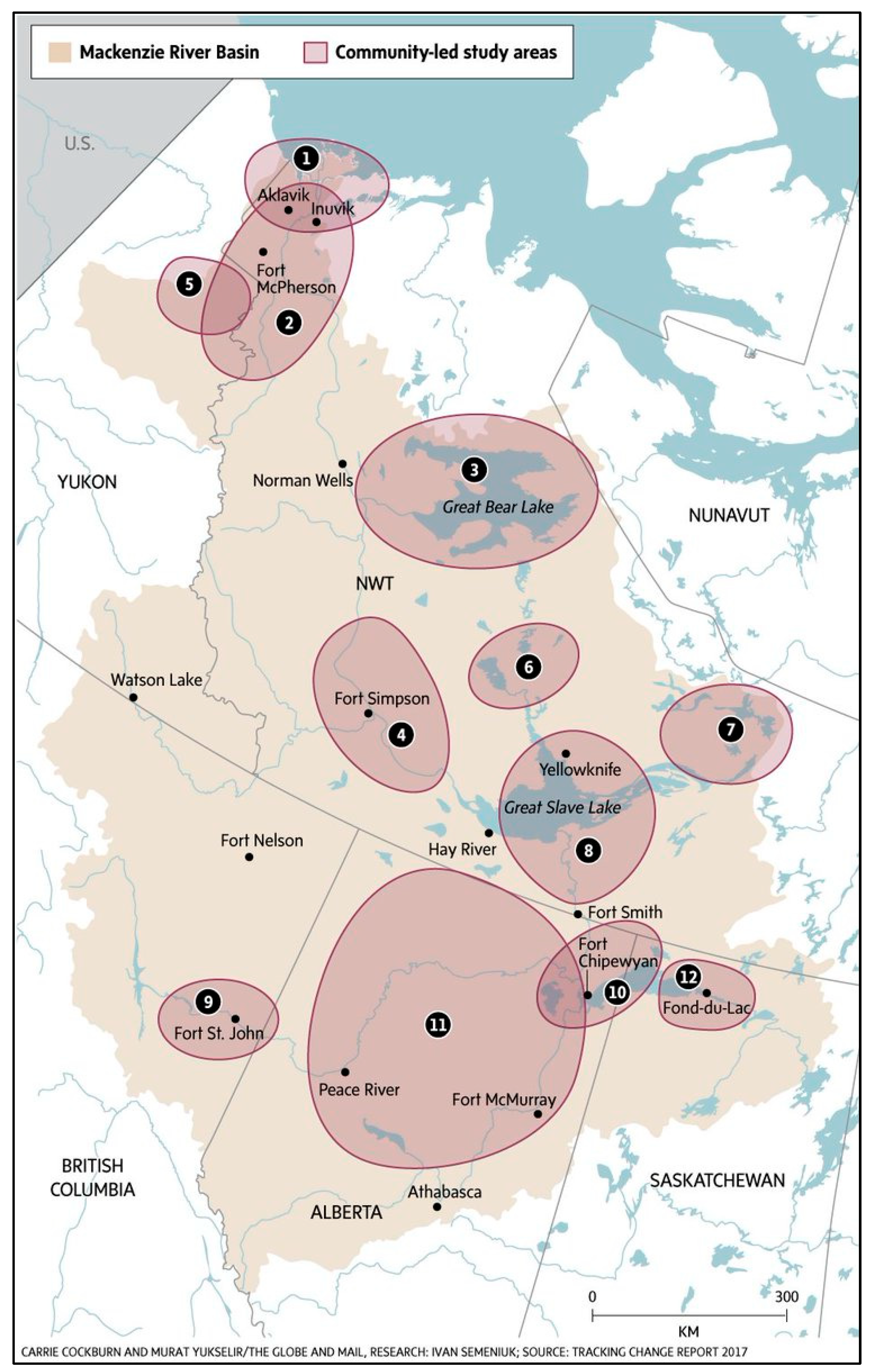
Figure 1. Research areas of the Tracking Change project in the MRB (adapted from [28]). Projects were led by: 1. Fisheries Joint Management Council, Inuvik Hunters and Trappers Committee, and the Aklavik Hunters and Trappers Committee. 2. Gwich’in Renewable Resources Board. 3. Sahtú Renewable Resources Board. 4. Deh Cho First Nations. 5. First Nation of Na Cho Nyäk Dun. 6. Wek’èezhìı Renewable Resource Board. 7. Łutsël K’e Dene First Nation. 8. Akaitcho Territory Government. 9. Treaty 8 Tribal Council Association of BC. 10. Mikisew Cree First Nation. 11. Treaty 8 First Nations of Alberta. 12. Prince Albert Grand Council.
Water 18 01642 g001
Figure 2. Indigenous Governments leading projects and student theses by sub-basin/region and year of completion [72,81,86,87,88,91,92].
Water 18 01642 g002
Table 2. Social and biophysical indicators.
ThemeObserved Pattern and ConcernSocial IndicatorsBiophysical Indicators
Declining Water LevelsLakes, rivers, creeks, and ponds lower; drying effect across the Basin (correlated with increased forest fire trends)
  • Systematic shoreline and riverbank reference tracking, sandbar change and hazards mapping
  • Number of inaccessible channels, tributaries
  • Camps/sites
  • Supply barge navigation timing and interruptions
  • Boat navigation tracking; Frequency of stranded or rerouted boats (e.g., Apps)
  • Implications for socio-cultural practices, livelihood, transmission of knowledge, skills and food security
  • Long-term water level gauge trends
  • Lake surface area (remote sensing)
  • Groundwater table depth
  • Tributary discharge rates
Increased Flow VariabilityUnpredictable flooding; fall high-water events; more frequent droughts; “100-year” events occurring more often
  • Freeze-up/break-up timing
  • Travel risks and incidents
  • Flood-related property damage
  • Qualitative/perception surveys or risk (i.e., anxiety)
  • Seasonal discharge variability index
  • Peak flow frequency
  • Drought duration metrics
  • Precipitation anomalies
Reduced Flooding & Ice Jam
Activity
Lack of spring floods in Peace-Athabasca and Slave Deltas; fewer sediment pulses
  • Delta connections
  • Oxbow lake connectivity
  • Slough “cleaning” events
  • Delta access routes maintained/lost
  • Ice jam occurrence frequency
  • Spring peak discharge timing
  • Floodplain inundation area mapping
Geomorphological ChangeRiver widening and shallowing; increased sandbars; shoreline recession (up to ~5 feet)
  • Number of navigational hazards
  • Traditional eddy/fishing site shifts
  • Camp relocation frequency
  • Channel cross-sectional profiles
  • Sediment load concentration
  • Sandbar extent mapping
  • Shoreline change rates
Sediment and Water Quality ChangeReduced sediment into Slave Delta; silt clogging nets during high water; algae/ecological shifts
  • Net fouling frequency
  • Eddy location: fish habitat change observations (impact of erosion)
  • Drinking water hauling frequency
  • Suspended sediment concentration
  • Turbidity
  • Nutrient levels (N, P)
  • Mercury levels
  • Contaminants
Warming Water TemperaturesLakes warming; fish distribution changes; soft fish flesh
  • Population and biodiversity tracking
  • Fish condition indices
  • Timing of fish runs
  • Surface water temperature trends
  • Ice cover duration
  • Thermal stratification depth
Beaver Population ExpansionDams blocking waterways; altered fish movement; water quality concerns
  • Blocked access routes
  • Fish camp water potability reports
  • Dam removal interventions
  • Beaver dam density mapping
  • Wetland area change
  • Flow obstruction frequency
Ice Regime ChangeLater freeze-up; earlier break-up; thinner ice; air pockets
  • Experience of freeze-up/break-up
  • Travel incidents on ice
  • Length trapping/hunting season duration
  • Ice thickness measurements
  • Freeze/break-up dates
  • Ice safety index
Access Impacts on LivelihoodsMore reefs and sandbars; higher travel costs; jet boat/plane reliance
  • Travel time to camps
  • Fuel costs
  • Harvest trip frequency
  • Property Damage
  • Navigable channel depth mapping
  • Barge route viability days/year
Cumulative
Effects
Reduced water reaching deltas; altered hydrographs; drying linked to forest fires
  • Fire frequency near drying wetlands
  • Perceived convergence zones (decline in access)
  • Regulated flow discharge data
  • Water withdrawal volumes
  • Water table depth trends
Disclaimer/Publisher’s Note: The statements, opinions and data contained in all publications are solely those of the individual author(s) and contributor(s) and not of MDPI and/or the editor(s). MDPI and/or the editor(s) disclaim responsibility for any injury to people or property resulting from any ideas, methods, instructions or products referred to in the content.