Review

Assessing Three Decades of Groundwater Modelling Applications in Greece: An Overview of Progress, Tools and Future Challenges

by
Christos Pouliaris
Department of Geology, University of Patras, University Campus, GR 26504 Rion, Achaia, Greece
Water 2026, 18(11), 1300; https://doi.org/10.3390/w18111300
Submission received: 1 March 2026 / Revised: 10 April 2026 / Accepted: 23 April 2026 / Published: 27 May 2026

Abstract

Water resource management in a growing world has arisen as one of the major pillars of future development, economic stability, and environmental sustainability. Within this framework, groundwater plays a key role in providing the necessary water for urban, industrial, and, most importantly, agricultural uses. One of the tools used for managing water resources and planning future developments is groundwater models; the use of this resource has expanded since the 1990s. In Greece, the application of groundwater models has spanned for almost three decades, with a variety of applications developed for many of the geologically complex areas around the country. The present study aims to fill a gap in present scholarship by presenting an exhaustive review of case studies identified in the literature by collecting and reviewing the available research that involves the development of groundwater models, highlighting their primary foci, the numerical tools used, and their expected implications for future developments. This review shows that most applications focus on seawater intrusion processes in coastal areas, where agricultural activities have added significant stress on local groundwater resources. Additionally, many studies also involve pumping optimization methodologies, aiming for the sustainable management of coastal aquifers. Groundwater models can provide answers to these questions and assist in the sustainable management of water resources.

1. Introduction

As the human population and economy continuously grow, and living standards have risen during the last few decades, the increased demand for food and water has had an impact on the natural resources available for further development [1]. Rising stresses (e.g., population rise in major cities, climate change, and pollution), especially in agricultural areas, which show a dramatic increase during the last 100 years (from 63 Mha in 1900 to 306 Mha in 2005, [2]), along with the lack of adequate management plans, have led to the depletion of water quantity and quality, especially in coastal areas, where the threat of seawater intrusion places an additional challenge for the natural rejuvenation of water resources. Indeed, irrigation is repeatedly reported to be consuming a vast amount of fresh water (70%), while at the same time the databases that are available for approaching agricultural water consumption are scarce and lack information [3]. In addition, a figure of at least 30% of the world’s groundwater systems is reported to be under distress, with reservoir volumes declining rapidly, effectively reducing the amount of water that is available for various uses [4]. Groundwater depletion and contamination have been severe as a result of human activities. This has led to a dramatic increase in research focusing on assessing the problems and proposing solutions [5]. Mitigation plans are often proposed, yet their actual effectiveness cannot be foreseen without the necessary predictive tools. To this end, groundwater models have been valuable for assessing the current situation and the suitability of suggested solutions.
Greece faces significant hydrogeological challenges originating from its complex geology and spatiotemporal heterogeneity regarding precipitation, with rainfall varying widely between western and eastern Greece, while there is also an increase in the number of intense winter events, with summers that are typically dry. Water stress is intensified by seasonal tourism, as population numbers on islands, and in major cities and coastal regions, can multiply during summer months, significantly increasing water demand right at the time when natural recharge is at its lowest. At the same time, water governance in Greece is fragmented across multiple ministries, regional authorities, municipalities, and water utilities, complicating coordinated planning, data sharing, and finalization of long-term water resource management plans. The mismatch between water availability and demand makes sustainable water management in Greece particularly complex under current and future climate conditions.
The use of modelling codes for the development of tools with the intention to understand the hydrogeological processes and identify optimal management strategies has a long history. Earlier studies have recognized two main groundwater-modelling categories: the hydraulic management models that lead to optimization of water-management strategies, and the policy evaluation models that are linked to the economic outreach of the management plans [6]. The identification of hydrological processes and geological structures, along with their interaction and mutual influence, leads to further developments in groundwater modelling. An important part of the development of every model is the type of boundaries. These involve three main types: the specified head boundaries, for which the hydraulic head is given; the specified flux boundaries, for which the flux across a boundary is given; and the head-dependent boundaries, for which the hydraulic head is calculated [7]. In groundwater models, these boundaries represent the water-related stresses, both positive and negative (sources and sinks), which can vary through time and define the flow conditions within the aquifer system. Most modellers choose to have a combination of those three types of boundaries, targeting a better replication of the physical system that they are trying to simulate.
In a recent review about the developments in groundwater modelling, Karatzas [8] mentioned that the groundwater flow models can be used for (i) predicting hydraulic heads and contaminants’ concentrations, (ii) backtracking towards a contaminant’s source, and (iii) assessing the research that has already been done, just to name a few uses. The distinction between the calibrated and predictive models is another aspect of model development that shows that the modelling procedure cannot always be transferable from one case to another. More precisely, predictive models, although built from data that are gathered in the field, may yield results that are not reliable, and so a calibration procedure is necessary in order to have a model that is actually useful [9]. By assessing the available literature, one can encounter many applications where groundwater flow models can have a major impact in the management of water resources, as they can be applied in many different ways, such as for analyzing stresses to groundwater, understanding flow patterns, supporting field data collection, evaluating future scenarios, and more [10]. Recent studies have highlighted how IoT (Internet of Things) sensors can benefit the groundwater models that mostly deal with resource management scenarios [11]. These include low-cost wireless sensor networks, remote sensing, integration with Geographic Information Systems (GIS) and data management interfaces, along with web applications for model building and result visualization.
With all these developments that have originated from the need to manage and predict groundwater evolution through space and time, groundwater models can provide valuable tools and results for supporting decision-making and management plans [12]. As the developments of capabilities and options for the simulation of groundwater processes evolved, several applications have also been developed for various areas in Greece, aiming at utilizing the modelling tools for solving a number of issues. These studies extend for almost three decades, from 1998 to 2025, with different philosophies and toolsets applied in areas with different characteristics. The present study aims at collecting, reviewing and presenting the efforts around the modelling of groundwater processes in Greece, for the purpose of summarizing this research for future reference. Initially, the methods for collecting and screening the literature that is included in the paper are presented, along with information on the process of model building and the modelling codes that are available. Next, the main characteristics and primary results are highlighted, along with the expected regional implications. Finally, the most important extracted outcomes are discussed, in addition to some thoughts on the complications of future developments in modelling applications.

2. Materials and Methods

2.1. Hydrogeological Modelling Framework and Priority Axes

Hydrogeological models are tools that simulate the hydrological processes that take place in aquifers. They use a large amount of data (e.g., groundwater levels, borehole cross-sections, pumping test data, geological data, chemical analyses, river discharge data, and groundwater well pumping data) to initially develop the conceptual model (i.e., the identification of the main processes and their characteristics), and then the mathematical model (simulation), which is adapted according to the objective of the simulation.
The modelling objective is of paramount importance when designing modelling activities because it defines the parts of the model in which detail has to be stricter and more precise, while in other parts of the same model, the detail needed is less. Having a well-defined modelling objective can navigate the researcher towards acquiring the appropriate data that is necessary for a specific application, providing a useful tool for the management and planning of groundwater resources in a specific area. If the goals of a model are not transparent, ensuring that the tool built would be useful becomes uncertain, and the modelling process may not worth the effort. As such, the modelling objective forms the first and most important pillar for modelling applications, regardless of the process that they are expected to simulate.
The second pillar is related to the data that is used for modelling calibration and validation. Although data acquisition may seem straightforward as a process, this is often not the case, as some models, groundwater models especially, suffer from a severe lack of complete data series. Many studies depend on either data from older publications, introducing uncertainty that may be difficult to estimate, or on field campaigns that cannot provide sufficient amounts of data unless performed for long periods. On the other hand, establishing and maintaining a monitoring network with automatic stations can require large amounts of capital and significant operational costs. Recently, the evolutions in machine learning and artificial intelligence have provided tools that can assist with filling in missing data and providing data projections. However, the acquisition of field data will always be a major aspect of modelling, defining the reliability of its results and the accuracy of its predictions.
The third and last pillar of modelling development is its conceptual model. This involves the structural and hydrogeological characteristics of the study area that need to be investigated for the understanding of the processes that take place within the system. An extensive review of the literature and data collection and, most notably, a fair amount of fieldwork, is necessary for the validation of existing information and acquisition of new information; these are the main components for building a realistic groundwater model. The latter can be the decisive factor for model building, since changes in the climate and the habits of people, land use and cover, can form an entirely different condition compared to the past. Nonetheless, fieldwork requires a substantial amount of effort and time, from experienced personnel who can provide fruitful information about the current conditions in an area. This can definitely increase the operational cost; however, it can prove to be critical in the construction of a model capable of providing an effective means for sustainable water resources management.
The present study is an effort to review the groundwater modelling applications that have been developed with respect to Greece. An extensive literature review led to the identification of relevant studies, regardless of the modelling methods that were used. The focus was on studies that were peer reviewed, in order to ensure the integrity of the presented results. The first step was to identify PhD theses that had created modelling applications for various areas. The names of those authors were used to identify published papers, either ones in which the thesis focused on the present topic, or others; searches also were conducted by using relevant keywords. The main sources for the detection of other papers were Google Scholar and Research Gate profiles, in addition to searches in relevant databases (e.g., Scopus, Web of Science). Results from unpublished sources were not included. The same applies to conference papers, as in many cases, they are not made available online by an official publisher, or what is available is just an abstract (sometimes extended), that does not provide all of the information about the model.
This study divided the presentation of modelling application by regions, rather than, e.g., modelling methods. This is considered to be a straightforward way to classify these studies, as, although modelling applications and methodologies may differ, the regional characteristics of an area are stable, thus making the various results and approaches comparable.
It should be also mentioned that on some occasions, the groundwater model is part of an integrated hydrological model, meaning that such a study would have a broader focus, which might have impact on the level of detail put into the hydrogeological model. Finally, unsaturated zone studies are not included in the present study, as they are out of scope, both in terms of scale and hydrological processes.

2.2. Modelling Software and Other Applications

Based on the extensive review of modelling applications in Greece, a vast majority are based on modelling codes that have either been developed or comprehensively integrated by the United States Geological Survey (USGS). These involve MODFLOW 2005 [13], primarily MT3D-MS [14], and also SEAWAT [15], as many applications focus on seawater intrusion. The MODFLOW family of codes have been extensively used because they are a very well established and are a robust set of modelling codes that can provide valuable results. Furthermore, a fair amount of Graphical User Interfaces (GUIs) have been developed by various sources, providing user friendly interfaces, with advanced pre- and post-processing options, making those codes a standard solution for groundwater modelling. A list of the available user interfaces is presented in Table 1.
Aside from the visualization capabilities that some of the aforementioned GUIs have, another advantage is that some optimization codes can also be directly incorporated into the MODFLOW family of codes, providing robust sensitivity analysis and parameter value estimation, leading to well-calibrated models that form useful tools for water resource management. The PEST [16] and UCODE 2014 [17] codes are some of the primary examples of optimization codes that can be used directly, even through the same GUI that is used for building a flow and/or transport model.
Another option that has been extensively utilized by studies in Greece is the Princeton Transport Code (PTC) [18], which is a three-dimensional groundwater flow and contaminant transport simulator that can combine the finite-element and finite-difference methods [8]. This option forms an alternative to MODFLOW, one that can also be used for building effective tools for groundwater management. FEFLOW [19] has also been utilized in some cases, especially for the modelling of contaminant transport, including seawater intrusion.
Comparing the various alternatives for developing groundwater models, FEFLOW could theoretically provide results with more detail because it utilizes a finite-element approach. However, codes with the finite-difference approach (MODFLOW and PTC) could also be more descriptive with additional discretization. In addition, a major advantage is that MODFLOW has many free alternatives, while FEFLOW commercial prices are rather high.
With the advances in modelling options, the rise of machine learning and surrogate models has given an entirely different approach to modelling, especially in optimization problems, reducing the computing power needed for complex model solving. However, the application of such methods in physical systems needs to further incorporate specific characteristics, such as spatial and temporal discontinuities [20,21].

2.3. Spatial Extension of Groundwater Modelling Studies

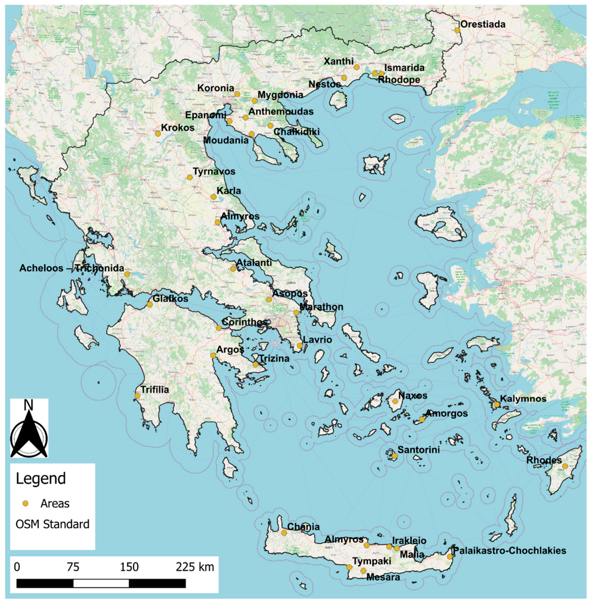
Reviewing the spatial evolution of modelling activities (Figure 1), some key features can be recognized. First of all, the majority of the studies are developed in coastal areas. This is the result of the concentration of anthropogenic activities in coastal plain areas, where most of the large cities in Greece are developed, along with other important commercial activities from the industrial and agricultural sectors. This leaves a significant part of the country without modelling applications. These areas are primarily mountainous, remote, and characterized by less stress to the groundwater resources. However, further investigating these areas and introducing model-assisted water resource management plans might be crucial in the future for the preservation of natural habitats and the protection of local ecosystems.
A similar trend can be also identified for the islands in Greece, which have been investigated only to a small extent. This comes in contradiction to the actual needs in those areas, many of which have considerable need for sustainable water resource management due to the low precipitation, high mean annual temperatures and extreme stress during the summer due to extensive tourism. However, their limited accessibility is probably the main reason why there are but a few studies for these islands focusing on topics similar to the models developed for inland areas. It is worth mentioning that one exception is the island of Crete in southern Greece, where a good number of modelling applications have been developed for the coastal areas around the island.

3. Areas with Modelling Applications in Greece

3.1. Acheloos–Trichonida

In this study, an integrated model for the simulation of both surface water and groundwater was developed. The hydrodynamic and qualitative components of the integrated model were simulated using two different modes (IRENE—HUD and IRENE—QUAL, respectively), both using a three-dimensional approach, written in the FORTRAN 95 programming language [22]. The application of the model was done under both experimental and real-world conditions, showing satisfying results for the simulation of a complex hydrological system, with the water table maintaining a relatively stable level throughout the hydrological year. However, further developments or applications using these modelling codes were not found in the literature, so the effectiveness and applicability of those codes were not tested in multiple settings, ensuring that the study eventually would have a relatively limited impact.

3.2. Almyros, Crete

This model was used to predict the flow and salinization status of a wider area during various climatic scenarios, aiming at identifying the optimal solution for the exploitation of the coastal karstic aquifer for drinking-water purposes [23]. The MODFLOW and FEFLOW models were compared with respect to their capability to simulate the aquifer dynamics. The seawater intrusion process was simulated only with FEFLOW. The comparison between the two models showed that the FEFLOW simulation results are slightly closer to the measured hydraulic head values, although both groundwater flow models seem to effectively capture the general trends. In addition, the FEFLOW seawater intrusion model was used for simulating water-management scenarios, regardless of the fact that the seawater intrusion model developed showed low accuracy. Various scenarios were tested, and the results showed that the seawater front could be pushed back if rainfall increases by 10% and well discharge volumes decrease by 50%, although this decrease seems very challenging and ambitious.

3.3. Almyros, Thessaly

This area has been extensively investigated, and there are many modelling applications that deal with the local aquifer and its overexploitation for the coverage of agricultural water needs.
The first-ever model developed [24] aimed at assessing the water balance in a coastal aquifer where extensive agricultural activities take place. The results showed that the groundwater discharge to the sea is sufficient for the prevention of seawater intrusion. Later, another study [25,26] involved the application of an integrated modelling system that included a surface hydrology model, a groundwater hydrology model, a crop growth/nitrate leaching model, a groundwater contaminant transport model and a groundwater–seawater intrusion model, aiming to evaluate the water resource status of a coastal area where intense agricultural activities take place. Using hydraulic head observations, crop yields and groundwater hydrochemical parameters (nitrate, chloride) for the calibration of the models, a valuable tool for the assessment of water-management scenarios and water-related stresses (groundwater abstraction, crops with increased water demand) in the area was developed. The study was later expanded [27,28], applying scenarios that were evaluated using the Crop Water Productivity (CWP), Partial Factor Productivity (PFP) for Nitrogen Use Efficiency, Economic Water Productivity (EWP), Water Exploitation Index (WEI+) and Reliability indices. Five scenarios were tested, showing that in almost all cases, the application of those schemes can have a positive result in the availability of water resources in the area.
The basis of this study was later enhanced by adding Med-CORDEX bias-corrected climatic projections for RCP4.5 and RCP8.5 scenarios and analyzing water resource management and agronomic scenarios [29,30,31,32,33]. The corrections were performed with Delta, Delta change of Mean and Variance, Quantile Delta Change, Quantile Empirical Mapping, and Quantile Gamma Mapping methods. The results show the potential the water resources in the area have for adapting under the circumstances of climate change, especially with respect to a seawater intrusion threat. It was recognized that in the future the precipitation (and as a result, groundwater recharge also) will decrease, while at the same time the temperature and potential evapotranspiration are expected to increase. As a result, the seawater intrusion front propagated in all the climatic scenarios that were tested. As an outcome, for delaying the groundwater quality degradation, a combination of reservoirs and specific irrigation practices (deficit and rain-fed irrigation) is suggested.

3.4. Amorgos

In this study, the seawater intrusion process is being assessed in a small coastal aquifer, with the use of a groundwater flow model based on the Princeton Transport Code (PTC), utilizing a sharp interface approach [34]. Alternative pumping scenarios are tested to evaluate the impact they would have on the water resources of the area and the evolution of the seawater intrusion front. The hydrodynamic dispersion was revaluated with the use of a factor for the correction of the sharp interface approach, aiming at improving the modelling results, which showed that only with a dramatic reduction in pumping rates (90%) and a periodic deactivation of pumping wells, the seawater intrusion could be mitigated.

3.5. Anthemoudas

This research involves the development of a single layer model with uniform thickness [35,36,37], using a combination of MODFLOW for the groundwater flow simulation and PEST for model calibration. The aquifer is developed within a granular formation but some rock formations of small extents are also included in the model. The hydraulic conductivity was divided into zones that were associated with the local geology. The model received input regarding the recharge volumes of the aquifer from a SWAT model that was also developed for the same area using open data from various sources, simultaneously evaluating their usefulness. The results showed that the water balance of the study area is stable compared to the balance recorded 20 years before the study, while the results were also used for defining areas that could potentially be polluted using MODPATH, providing insight about the security of local water resources.

3.6. Argos

In one of the earlier applications of modelling activities in Greece, the model was developed for a coastal area where intensive agricultural activities take place [38]. The primary aim of the model is to identify the mechanisms that led to the quantitative and qualitative deterioration of the water resources in the study area by using MODFLOW. The PEST code has been utilized for performing the sensitivity analysis and calibration of the model, leading to results that quantify the components of the water balance that cannot be measured with conventional techniques. This model was further developed for the simulation of the transport of chloride ions, assessing the seawater intrusion processes taking place in the aquifer, using the MT3D code. In the final steps, various scenarios for the rejuvenation of the aquifer system to the pre-exploitation state were tested, comparing natural restoration or managed-aquifer recharge schemes. Recent studies [39] utilized the FREEWAT platform in QGIS and the UCODE 2014 code to develop a pre-development groundwater model to identify the system dynamics and better estimate the hydraulic properties’ values. This approach could be very beneficial to the understanding of groundwater systems by defining specific remediation goals, aiding the application of improved water-management plans for aquifer restoration.

3.7. Asopos

For the heavily industrialized area around the Asopos river, the modelling applications have focused on the ultimate resolution and transport of various contaminants [40,41]. Hexavalent chromium has been highlighted as a serious threat in the area, so the different sources of chromium were identified, and a groundwater flow and contaminant transport model was developed using PTC. Climate change effects were also simulated to evaluate the impact they could have on the groundwater, with results highlighting the need for sustainable water-management plans in the area. In addition, the anthropogenic source of chromium was identified, while for the northern part of the basin, the characteristics of the contaminated plume were defined and a remediation plan was suggested.

3.8. Atalanti

The model [42] aimed at predicting the aquifer response in future stresses, such as drought periods or extreme rainfalls. In addition, the water balance and aquifer dynamics were assessed with the use of the MODFLOW code. The nitrogen load that is applied for fertilization of the cultivated land in the area is calculated and used as a pollutant source in the contaminant transport model that is built using MT3DMS. Due to overexploitation, the study area is under seawater intrusion, so this process was also simulated with the use of the SEAWAT code. The final model was used to simulate various scenarios of increased and reduced aquifer recharge, groundwater pumping, and fertilization loads, for the assessment of the seawater front response. In the end, a scheme for the restoration of the aquifer and treatment of seawater intrusion and nitrate pollution is presented, aiming at providing a feasible solution for the local water resources.

3.9. Chalkidiki

The study primarily focuses on the development of a climatic model using the RegCM4 model, in addition to a hydrological model using the ArcSWAT code, in order to feed the hydrogeological model the necessary input information [43,44]. The hydrogeological model was developed using the MODFLOW code and aimed at the assessment of the present and future impacts of climate change in the groundwater resources of the area. The sensitivity analysis of the model showed that the model is highly affected by changes in the hydraulic conductivity of the aquifer, while the entire catchment is also highly affected by the variability of climatic parameters. The final results showed how the drawdown of the water table evolves under climate change stresses, with hydraulic heads’ values that are below the sea level, increasing the threat of seawater intrusion, while the changes in the stream discharge volumes are insignificant. This output can be valuable when planning management schemes by bringing focus to the components of the hydrogeological system that can have significant positive impacts for the region.

3.10. Chania, Crete

In this study, a combination of PTC and the ArgusOne model is applied in a plain area in the Chania region for the simulation of groundwater flow and solute transport [45]. The results of the model gave an insight into the water balance in the area, showing that the difference in hydraulic heads between wet and dry periods is insignificant and the aquifers are secure against seawater intrusion.

3.11. Corinthos

The MODFLOW code is utilized in this study for the simulation of groundwater flow in an area with intense agricultural activity [46]. The calibration of the model is performed using the PEST code, while a sinusoidal equation is also used as an approach to the problem of the missing hydraulic head data, providing a potential solution to the data scarcity problem that often affects groundwater models. The calibrated model was tested for a number of scenarios connected to the planned water-management-related projects in the area. The results highlighted the importance of recharge in the study area and how this process is closely related to climate change.

3.12. Epanomi

This model was developed for the assessment of coastal aquifers and the prediction of seawater intrusion under various stresses, using the newly developed SISWIM model [47] for simulating non-mixing liquids. The model was tested in theoretical and lab conditions to refine the model’s assumptions. Genetic algorithms were also used for the optimization of the pumping rates of multiple pumping systems, while seawater intrusion was simulated using the sharp interface approach. The position and geometry of the seawater intrusion front were successfully simulated, showing that the aquifer depth and layer bottom topography highly affect the intrusion mechanisms. However, other applications using the same model were not found in the literature, so the limitations and applicability of the model in other cases have not yet been tested.

3.13. Glafkos

The study involves the development of a groundwater flow and transport model for the assessment of seawater intrusion in a coastal aquifer, using a combination of MODFLOW and SEAWAT [48,49]. The aquifer is characterized by significant water level fluctuations during the hydrological year, so the model aimed at estimating how the various fluxes that affect the water balance (recharge, exchange with surface water, groundwater abstraction rates, etc.) vary through time. For the calibration, the PEST code was utilized, while MODPATH was also used for delineating the capture zones of the exploitation wells. The calibrated model was then utilized for the assessment of the various components of the water balance, resulting in the evaluation of the vulnerability of the wells that are exploited for domestic drinking-water supply. In the context of the identification of the seawater intrusion risk, protective measures for the preservation of the wells’ quality status are provided, specifically, the suggestion of a series of hydraulic barriers. This model is one of the applications that give prominence to the capacity of modelling and how it can be used for the testing and implementation of remediation schemes.

3.14. Irakleio, Crete (Hersonissos)

The coastal zone of Irakleio in Crete has been investigated for the purpose of understanding the seawater intrusion processes in the local karstic aquifer. The modelling methodology mainly uses the sharp interface approach, either for investigating the impact of industrial activities in the aquifer with PTC [50], or for the optimization of well pumping with simultaneous prevention of seawater intrusion, using MODFLOW and GWM [51,52]. The results show that a dramatic decrease in pumping rates would be the only measure able to prevent the phenomenon, due to the fact that the seawater intrusion is difficult to battle when the front reaches deep into the aquifer. The FEFLOW model has also been used for comparing equivalent porous-medium and discrete-fracture modelling, with both the density-dependent and sharp interface approaches [53], highlighting the fact that more complex models can provide more realistic results, although simpler models can also be helpful under certain conditions.
Other studies have focused even more on the use of optimization algorithms, either for determining cost-effective solutions in groundwater management with the Simplex and Differential Evolution methods [54], or by using Artificial Neural Networks (Radial Basis Function Artificial Neural Network—RBFN and Differential Evolution) for the optimization of pumping rates in the area.
The most recent set of studies developed an algorithm to maximize the pumping rates of fresh groundwater in coastal aquifers, using a stochastic approach that allows for the protection of the wells from seawater intrusion [55,56,57]. In the study, the ALOPEX stochastic optimization method is utilized for the optimization of pumping rates, in collaboration with the Princeton Transport Code (PTC). The algorithm is applied first in a theoretical aquifer and then in a real one, for which a groundwater flow and transport model already existed. The method highlighted areas around the pumping wells where the groundwater quality is monitored so that the seawater intrusion can be identified. The final results include a well-pumping management plan for the sustainable abstraction of groundwater in the area and the prevention of seawater intrusion.

3.15. Ismarida

This model was developed, using the MODFLOW code, for evaluating the impact of the pumping in the plane area north of Ismarida lake [58]. The model was used to test four different water-management scenarios, concluding that a 33% decrease in the pumping rates in the area could lead to the present maintenance of similar conditions, while in order to improve the availability of groundwater resources and ensure sustainability, a reduction of around 41% would be necessary. The interactions and potential impacts on the lake are not discussed in the study, except for the discharge of the river Vosvozis into Ismarida lake.

3.16. Kalymnos

The coastal aquifer of Kalymnos has been under investigation, with focus given to pumping optimization and the prevention of seawater intrusion. An early study used Evolutionary Algorithms and the sharp interface approach to optimize the pumping schedule of wells, while at the same time protecting the groundwater resources of the area from seawater intrusion [59], highlighting the sensitivity of such an approach to recharge and hydraulic conductivity heterogeneity. This study formed the basis for further investigation on the optimization of pumping rates based on various approaches [60,61,62,63]. A combination of the sharp interface approach with machine learning (random forest and Gaussian process regression) for pumping optimization, the results of which were used for testing four machine learning models (random forest, Gaussian process regression, linear regression, support vector machines), showed that, in all cases, the Gaussian regression model was producing the best results. Surrogate models (radial basis functions and kriging) were also supplied with data from physically based models to help improve its performance, reducing significantly the optimization problem solution time needed, compared to variable density and solute transport models. Multi-fidelity optimization has also been utilized for the reduction of computational time when solving pumping optimization problems, without compromising the integrity of the modelling results.

3.17. Karla

The aquifer that exists in the wider area of lake Karla is the hydrosystem in Greece with the largest number of modelling-related publications. This system has been extensively studied due to its sensitivity and, at the same time, extensive exploitation.
Many of the publications are based on a series of models with different combinations, each time aiming at different simulation goals, either by alternating the simulation progress core or by incorporating additional tools. The basic core includes a surface hydrology model (UTHBAL) [64], a reservoir operation model (UTHRL) [64], a groundwater model (MODFLOW) and a lake–aquifer interaction model (LAK3) [65]. Based on this structure, geostatistics (GSLIB) and groundwater resources management (GWM) modules were added to the modelling sequence, in order to give an insight into the parameters that play a significant role in the restoration and management of the lake and the adjacent aquifer [66]. Other codes, such as the Canadian Centre for Climate Model Analysis General Circulation Model (CGCMa2), were also utilized for the identification of the optimum volumes that can be extracted from the aquifer and the well location for which the abstraction of groundwater would have the smallest impact [67,68]. Monte Carlo simulations, the Geostatistical Sequential Gaussian Simulation (SGSIM) and the GSLIB model have also been used for the assessment of hydraulic conductivity and aquifer uncertainty through stochastic modelling [69,70,71,72]. The water deficit of the hydrosystem of lake Karla, along with management scenarios describing the reconstruction of the lake and the reduction of groundwater exploitation, have also been investigated [73,74]. Finally, a holistic approach in the simulation of water resources is applied, focusing on the effects of climatic changes in the regional water balance, with the surface water (lake) component incorporated in the groundwater flow model, which was calibrated using the PEST code [75].

3.18. Koronia

The study combined a groundwater flow model with fuzzy logic optimization algorithms for the assessment of water resources management scenarios regarding alternative well pumping rates [76]. The model, apart from the local aquifer, also involves a lake, while the water resources in the entire area have deteriorated. The basic groundwater flow model was built using MODFLOW. The three optimization methods included the linear programming (Simplex), classic fuzzy logic and modified fuzzy logic. The results showed that the methodology with the best solution is the modified fuzzy logic due to the fact that higher pumping rates can be achieved, while this method can also be used for the sensitivity analysis of the model. This study highlights the positive impact of the combination of fuzzy logic and groundwater modelling; however, results of such complementary use of models, in order to be useful, need to be compared to the characteristics and limits of the natural systems.

3.19. Krokos

The issue of groundwater with high nitrate concentrations affecting springs that are used for domestic water supply is the topic of this study [77]. Nitrate originates from intensive agricultural activities in the study area that deteriorate local groundwater resources. The MODFLOW and MODPATH codes are utilized for the delineation of springs’ protection zones, with the simulation results highlighting the need for reliable field data that will enhance modelling applications. This is one of the cases where groundwater models can be used for water resource management; however, this model is rather simple and can only be viewed as a first approach to similar problems.

3.20. Lavrio

The coastal hydrosystem of Lavrio has been simulated using a variety of approaches. The area includes two distinct aquifers, specifically, a granular aquifer in the alluvial plain and a karstic aquifer that underlies the first [78,79], with both being adjacent to the coast and under seawater intrusion. Alternative MODFLOW 2005 models that were calibrated using the UCODE 2014 code were tested [80], providing an insight into the optimal configuration and selection of the boundary conditions in the study area, and highlighting the dominant hydraulic processes that take place. A MODFLOW CFP model that focused on the karstic aquifer has also been developed for the area, combined with a new methodology for implementing field fracture data into the MODFLOW CFP model [81], producing improved results compared to the base MODFLOW 2005, while at the same time giving information about the karstic specific processes that take place within the aquifer. This is the only model in the present study that involves the simulation of karstic aquifers in a very explicit manner, providing an alternative to traditional MODFLOW models.

3.21. Malia, Crete

This study combines the use of the particle swarm optimization (PSO) algorithm with the PTC model for the assessment of seawater intrusion in a coastal aquifer, using the sharp interface approximation [82], aiming at maximizing the abstraction rates from wells, without jeopardizing the quality of groundwater. Two management scenarios are tested for preventing the propagation of the seawater intrusion front, with the results showing that a reduction of 18.75% in the wells’ pumping rates would be necessary in order to secure groundwater availability in the future, while a smaller reduction (16.25%) could be effective if the number of the wells that are used for the exploitation of the aquifers is significantly decreased (42.4%).

3.22. Marathon

The hydrogeological investigation in Marathon led to the development of a MODFLOW 2005 model, using the FREEWAT platform in the QGIS environment [83,84]. Consequently, the MT3DMS and SEAWAT codes were utilized for the simulation of seawater intrusion. The final model was used for testing various managed-aquifer recharge (MAR) scenarios, forming the basis for the development of a MODFLOW CFP model used to simulate MAR schemes that utilize horizontal wells [85]. Finally, an improved version of the SEAWAT model is provided for the area [86], with the calibration of the various parameters performed using UCODE 2014.

3.23. Mesara, Crete

The study involves the development of a groundwater flow model in an area with complex hydrogeological conditions due to active tectonic activity [87,88], leading to the need for a unification of separate hydrogeological basins. In addition, extensive agricultural activities take place in the area, in a locale where the aquifer is exploited through a large number of boreholes. For that reason, the first step involved the calculation of potential evapotranspiration and the simulation of surface hydrology, which provided infiltration input data for the groundwater flow model. The MODFLOW model aimed at addressing the available field studies and validating their findings, assessing the hydraulic interaction with the surface water bodies and highlighting the areas where hydrogeological knowledge is poor. The final results gave an insight into the volumes of water that reach the aquifer and originate from the streams in the area, while the derived water budget showed that there is a water deficit in the groundwater system.

3.24. Moudania

The modelling applications in the area of Moudania focus on the delineation of protection zones around production wells, the simulation of groundwater flow under conditions of scarce data, the evaluation of seawater intrusion risk, and relevant protective measures for groundwater quality deterioration prevention [89,90,91,92,93]. For achieving those objectives, the MODFLOW, MODPATH and SEAWAT codes are utilized for the assessment of coastal aquifer management. The aggregate results highlight the effects of certain pollution point sources on groundwater quality, while an artificial recharge scheme based on an economic and environmental efficiency feasibility study is proposed. The results of those modelling applications were also used for evaluating alternative methods for the identification of protection zones around wells, taking into account economic characteristics [94], but also attempting to minimize the pumping rates in an effort to reduce energy consumption [95].
Further studies in the area [96,97] capitalized on prior knowledge and developed machine learning models (Artificial Neural Networks—ANN, Long Short-Term Memory—LSTM and Support Vector Regression—SVR) for the simulation of seawater intrusion, while the impact of fertilizers in the already nitrate-contaminated groundwater was assessed, showing that a 30% reduction in fertilizer usage would lead to more sustainable conditions.
Another study in the area aimed at delineating the regions around a single well where restrictions for various activities should be applied, aiming at the protection of groundwater resources [98,99]. To better implement those restrictions, the uncertainties of the geological structure of the aquifer were assessed with the use of a groundwater flow model. Various methods, such as the Latin Hypercube Sampling method or the T-PROGS software (Version 2.1.) were used for the assessment of the uncertainty in the model, which was built with the use of the MODFLOW 2000 code. The results highlighted the areas where restrictive measures need to be implemented for the protection of the regional groundwater resources.

3.25. Mygdonia (Koroneia, Volvi)

An integrated water resources model was developed for the study area, with the surface water component simulated with UTHBAL and the groundwater component simulated with MIKE SHE, using the calibrated models to predict the response of an overexploited system in the future based on different scenarios [100,101,102]. A major aspect of the model is the hydraulic connection between the local aquifer, the streams, and the two lakes (Koronia and Volvi) that are present in the area. The results of the integrated model identified the most efficient strategy for the sustainable development of the area and the protection of water resources, under the prism of a reduced annual precipitation (17%) and increased mean annual temperature (2.9 °C). This goal could be achieved with the application of demand-management actions, such as the re-evaluation of selected crops, decreased proportions of agricultural land, the management of lakes’ overflows and elevations, and the enhancement of the water availability by diversion of nearby streams, with the first two scenarios providing the most satisfying results with respect to water resource preservation.

3.26. Naxos

In this model, an entire island was simulated using different hydraulic conductivity zones for the various geological formations [103]. The special feature of this study is that it is applied in an area characterized mainly by fissured rocks, making it the only modelling application in Greece with such characteristics. A SWAT model was developed in the first steps, producing the recharge values that were used in the groundwater flow model, which was developed with FEFLOW. Future scenarios related to the availability of groundwater for various uses were examined, with results showing that for the summer period, when the need for drinking water increases due to tourism, the availability will continue to be limited. This model is an effort to simulate an area with high heterogeneity, with formations that form weak aquifers, which are associated with results that include uncertainty and are difficult to evaluate.

3.27. Nestos

The hydrological basin of the Nestos river, one of the largest rivers in Greece, has historically been extensively studied, since it has been under exploitation for many years. Preliminary studies used modelling applications of MODFLOW to assess the water resources of the area, using alternative scenarios to investigate the capacity of groundwater to cover the need for irrigation water [104]. Due to the river itself being a very strong boundary condition that highly affects local conditions, the studies in Nestos divide the river basin between the western and eastern sides of the river, considering that there is no hydraulic interaction between the two. For the eastern side [105,106], the model was developed for an unconfined granular aquifer, aiming at assessing the water balance of the system. The system is highly affected by the adjacent river, which is the main source of water for the simulated aquifer. The pumping of groundwater for irrigation purposes is the main output of the system. For the western side [107,108], the model was developed in order to assess the water balance of an aquifer that is under intense exploitation for the coverage of agricultural water needs. The results of the study quantify the amount of water that is exchanged between the aquifer and the river system, while the importance of the wells’ pumping rates in the aquifer balance is highlighted.

3.28. Orestiada

The study involved the development of a multi-layer model for an alluvial aquifer, in an area characterized by heavy agricultural use [109], using the MODFLOW code. The boundaries of the layers were defined using the spatial distribution of a factor analysis that is related to water–rock interactions, based on Ca2+, Mg2+, SO42+ and Cl concentrations. In addition, the pumping rates were calculated based on the recorded power consumption of the pumps within the wells. The results showed that the water budget is highly affected by changes in the recharge and the pumping levels for agricultural purposes and less by the river Evros, which is adjacent to the area. One major aspect of this study is that it used an interpretation of the results of hydrochemical analyses for selecting the boundary conditions used in the model, differentiating it from other applications.

3.29. Palaikastro-Chochlakies, Crete

This study focuses on a karstic aquifer, combining a FEFLOW model and the PaPRIKa vulnerability method, using the hybrid EPC-DF approach [110] for managing groundwater resources in a complex hydrogeological region. The simulation results gave an insight to the storage processes (diffused or concentrated) within different parts of the karstic aquifer after testing different management scenarios, aiming at evaluating the potential of applying artificial aquifer recharge in the area. Similar combinations of modelling and vulnerability indices could potentially provide useful results in areas where groundwater contamination from point sources is identified as a research topic.

3.30. Rhodes

The response of a coastal aquifer to drought, in addition to pumping rate optimization, are the main foci of the modelling applications in Rhodes [111,112]. In the eastern part of the island, the SEAWAT code is used for the simulation of the seawater intrusion, while recharge is calculated with the Medbasin-M hydrological model. The Reconnaissance Drought Index (RDI) is also utilized for the assessment of drought, proving to be a reliable tool for evaluating the response of an aquifer to a period with reduced precipitation.
In the northern part, the PTC model, in combination with artificial neural networks (ANNs), is used for assessing the response of the aquifer to alternative pumping rates sufficient to covering the water needs and, at the same time, maintaining the sustainability of water resources. The results show that ANNs can provide outputs that are comparable to the PTC model, but require much less computational time when used for simulating complex natural systems.

3.31. Rhodope

This model is developed for an area with extensive agricultural activities that have a severe long-term impact on the local water resources [113,114,115]. For the simulation of groundwater flow, the MODFLOW code is utilized, while the sensitivity analysis and calibration were performed using the UCODE 2014 code, which provided satisfactory results for the parameter values of the model. The model was able to reproduce the severe cone of depression due to overpumping, assess the water balance of the aquifer and simulate prediction scenarios for alternative pumping schemes.

3.32. Santorini

For the central area of Santorini, the modelling efforts focused on the optimization of aquifer exploitation [116,117,118,119,120]. Studies aimed at modelling the propagation of seawater intrusion within the coastal aquifer, using FEFLOW. A number of scenarios were tested for evaluating the effectiveness of several aquifer replenishment schemes. The research in the area further evolved with the use of Artificial Neural Networks for the optimization of the pumping schedule, along with SEAWAT for the simulation of density-dependent groundwater flow. The primary focus of this study is the testing and evaluation of optimization methods and techniques, along with the adoption of a simplified approach to aquifers that are developed in complex volcanic formations.

3.33. Trifilia

This model was developed for a karstic aquifer, aiming to assess the water balance in the hydrogeological system and contribute to the management of water resources in the region, with the use of the MODFLOW code [121,122]. The pumping test results that were available for the area gave a wide range for the hydraulic properties of the karstic aquifer, making the clarification of the flow regime within the region highly uncertain. The area was divided into 10 different zones, depending on the various geological conditions, for the assessment of groundwater recharge. Alternative scenarios, including the probability of drought and variations in the volumes that are extracted from the aquifer, showed that the aquifer, due to its large storage potential, is not highly affected by changes in the water balance and, more significantly, the flow gradient is still positive towards the sea, preventing seawater intrusion.

3.34. Trizina

For the Trizina area, three groundwater flow and transport models were developed, using MODFLOW-MT3DMS, FEFLOW and PTC, aiming at comparing the results and deciding which is the best approach [123]. Graphical and statistical results from the three models were evaluated, and it was concluded that FEFLOW outperformed the other applications in both categories. However, actual differences in the final results are insignificant, proving that all alternatives can perform efficiently under the same conditions and minor discrepancies could potentially be site-specific.

3.35. Tympaki, Crete

This study utilized a FEFLOW model for simulating the density-dependent groundwater flow in a coastal area, capitalizing on results from geophysical investigations [124]. The geometry of the model layers was defined using the transient electromagnetic method, which is a non invasive, dost effective exploration method. The results were used to identify the propagation of the seawater intrusion front in specific areas within the aquifer where the installation of new abstraction points should be avoided.

3.36. Tyrnavos

This model is developed for an aquifer with complex water balance [125]. The aim is to assess the sustainability of the groundwater resources under various exploitation schemes, focusing on the coverage of the present water needs in alternative water resource management scenarios. The MODFLOW code was utilized for simulating the hydrogeological processes. The hydraulic conductivity is divided into zones that are different for each layer, depending on the results of pumping test analyses and local geology, and for different locations. The sensitivity analysis of the model showed that the hydraulic conductivities are the most sensitive parameters of the model, while the specific yield and specific storage have lower impact in the model results. The management scenarios were based on projections from various climatic models. The results showed that using managed-aquifer recharge applications could have a positive impact in the case of the most unfortunate scenarios.

3.37. Xanthi

This model represents probably the oldest attempt to simulate groundwater flow in Greece using MODFLOW [126,127]. It was developed with the aim of assessing the possibility of using old river courses for enhancing the recharge of the aquifer by reactivating them. The model was based on a set of field tests that were performed for gaining insight into the capability of old river courses to maintain water and the ability of the aquifer to absorb it. The final model was used for testing different scenarios and the optimal scenario for applying a successful artificial recharge scheme was identified. A later study combined SWAT (for assessing the recharge component) and MODFLOW simulations, along with the Simplex optimization algorithm, for testing irrigation water-management scenarios [128].

4. Discussion—Future Challenges

This investigation into the modelling applications in Greece highlights some common characteristics about the trends that have been followed during the past years. Most of the models built are for areas characterized by plains, where granular aquifers have developed. This trend was driven by the need to unravel the hydrogeological conditions in areas where intense agricultural activity takes place. In many cases, the lack of water resource management plans led to uncontrolled installation of pumping wells that overexploited the water reserves of the aquifers. As the years passed, this led on many occasions to inversions in hydraulic gradient, which resulted in the intrusion of seawater into the aquifer, deteriorating the quality of the groundwater. Consequently, water resource management plans, including the application of modelling tools, came to be an inevitable need, assisting the continuation of the economic activities in the study areas. However, in many cases, the primary factor associated with the decrease in groundwater quality and quantity, i.e., the pumping of groundwater and, more precisely, the pumping rates, is mostly estimated in those studies, due to a lack in continuous monitoring, the large number of unregistered wells and the poor supervision by the governmental bodies. Subsequently, most of the studies included in the present review show those common characteristics.
Studies that are based on other types of aquifers, those developed either on karstic or fissured rocks, are quite uncommon in Greece. Although these two types of aquifers show entirely different flow regimes, what they do have in common is the fact that they are highly affected by the local tectonics. The complicated tectonic regime in Greece is due to the convergence of the African and Eurasian tectonic plates, which forms a subduction zone where rock sequences go through stresses that may even alter their petrological composition. This leads to rock formations being under tectonic control, with extensive folds and faults forming a highly intricate geological structure, which makes the understanding of groundwater flow a very demanding task. Combined with the fact that, on many occasions, these rocks are in mountainous areas that are mostly inaccessible, with few observation points (i.e., boreholes), or under dense forests, this means that these areas have been investigated only in a small number of publications.
Although crucial in the understanding of regional hydrological conditions, the application of coupled models that simulate both surface water and groundwater is very limited in Greece. This could be partly associated with the fact that in many areas the surface water network is poorly developed and flow in streams is seasonal or superannual. However, this is not always the case, especially in parts of northern and western Greece. As such, future applications of coupled surface–subsurface models are expected to expand as integrated water resources management becomes more crucial under climate change. The integration with climatic models could also be implemented with the aim of the inclusion of the entire hydrological cycle in the tools that are used for decision-making and planning.
With the development of alternative techniques that can be used for the simulation of various systems, a gradual shift towards machine learning methods is recorded, although traditional methods are still being used extensively. As each approach can have pros and cons, a combination of the two might be optimal, with traditional methods being better at simulating the natural system and its spatial heterogeneity and machine learning succeeding at filling the data gaps and providing many optimization alternatives.
The analysis of uncertainty, in combination with effective model calibration processes, can also highly benefit the models, providing results that are trustworthy and replicable, if need be. This especially applies to uncertainty analysis; apart from presenting the limitations of each model, it can be used when further developments are planned and highlight the parts of the model that can be improved and could benefit from additional investigations.
As the capabilities of the models provided to the researchers evolve every day, the future of groundwater modelling is still dependent on the three pillars of modelling, as mentioned in the previous sections. Modelling goals might change, even for a specific model; however, a development strategy will still be decisive as to the model structure and attributes. Collecting reliable data that provide the necessary spatial and temporal analysis will give the researchers the information needed to create tools that can predict the systems’ responses to climatic and anthropogenic factors. Additionally, building a robust conceptual model will always be fundamental to incorporating the complexity of hydrogeological systems and transferring it to a numerical model.
As climate change gradually increases the stresses in local water resources, future challenges in groundwater modelling in Greece involve the expansion of its application in areas where rock formations have a large groundwater storage potential, mainly in the western part of the country, where karstic aquifers are formed. In addition, in areas that have already been investigated, further developments that will provide solutions for increased water demand through the testing of alternative future scenarios are expected to materialize, giving valuable feedback as to what has already been done. This could lead to even more reliable simulation results, forming the basis for an efficient and sustainable management of water resources. Finally, the greatest challenge is probably the application of modelling tools in many of the islands, where groundwater models can play a significant role in understanding the processes and constructing mitigation strategies that will ensure the availability of suitable water for all uses for as long as possible within a hydrological year.

5. Conclusions

The present study focused on presenting an overview of the groundwater modelling applications that are built for localities in Greece. The regions for which models have been developed were identified and the models’ characteristics were highlighted. The modelling applications included in the present study vary from rather simple models that aim at providing insight into the individual components of the water budget, to coupled models that combine a number of techniques to simulate complex hydrological processes at high levels of detail, to modern approaches to groundwater modelling that utilize optimization algorithms in order to propose solutions for crucial topics. In accomplishing this, the availability of tools and the evolution of modelling as a method for assessing problems related to water resource management have undoubtedly seen major improvement in recent years. As future challenges related to climate change and human activities evolve, the prominent areas of interest for the upcoming modelling applications have been highlighted. The present study aspires to promote the involvement of modelling application in decision-making regarding the assurance of groundwater sustainability in the imminent future.

Funding

This research received no external funding.

Data Availability Statement

The PhD Theses that are presented in the study are available at the National Archive of PhD Theses (https://www.didaktorika.gr). Articles are available from the corresponding publishers.

Acknowledgments

The author would like to thank the two anonymous reviewers for their comments, which improved the manuscript.

Conflicts of Interest

The author declares no conflicts of interest.

References

  1. Bierkens, M.F.P.; Wada, Y. Non-renewable groundwater use and groundwater depletion: A review. Environ. Res. Lett. 2019, 14, 063002. [Google Scholar] [CrossRef]
  2. Siebert, S.; Kummu, M.; Porkka, M.; Döll, P.; Ramankutty, N.; Scanlon, B.R. A global data set of the extent of irrigated land from 1900 to 2005. Hydrol. Earth Syst. Sci. 2015, 19, 1521–1545. [Google Scholar] [CrossRef]
  3. Siebert, S.; Burke, J.; Faures, J.M.; Frenken, K.; Hoogeveen, J.; Döll, P.; Portmann, F.T. Groundwater Use for Irrigation—A Global Inventory. Hydrol. Earth Syst. Sci. 2010, 14, 1863–1880. [Google Scholar] [CrossRef]
  4. Boretti, A.; Rosa, L. Reassessing the Projections of the World Water Development Report. Npj Clean Water 2019, 2, 15. [Google Scholar] [CrossRef]
  5. Jia, X.; Hou, D.; Wang, L.; O’Connor, D.; Luo, J. The Development of Groundwater Research in the Past 40 Years: A Burgeoning Trend in Groundwater Depletion and Sustainable Management. J. Hydrol. 2020, 587, 125006. [Google Scholar] [CrossRef]
  6. Gorelick, S.M. A Review of Distributed Parameter Groundwater Management Modeling Methods. Water Resour. Res. 1983, 19, 305–319. [Google Scholar] [CrossRef]
  7. Anderson, M.P.; Woessner, W.W. Applied Groundwater Modelling—Simulation of Flow and Advective Transport; Academic Press: San Diego, CA, USA, 2002. [Google Scholar]
  8. Karatzas, G.P. Developments on Modeling of Groundwater Flow and Contaminant Transport. Water Resour. Manag. 2017, 31, 3235–3244. [Google Scholar] [CrossRef]
  9. Hill, M.C.; Tiedman, C.R. Effective Groundwater Model Calibration; John Wiley & Sons Inc.: Hoboken, NJ, USA, 2007; Volume 978. [Google Scholar]
  10. Zhou, Y.; Li, W. A Review of Regional Groundwater Flow Modeling. Geosci. Front. 2011, 2, 205–214. [Google Scholar] [CrossRef]
  11. Aderemi, B.A.; Olwal, T.O.; Ndambuki, J.M.; Rwanga, S.S. A Review of Groundwater Management Models with a Focus on IoT-Based Systems. Sustainability 2021, 14, 148. [Google Scholar] [CrossRef]
  12. Höglund, N.B.; Sparrenbom, C.; Barthel, R.; Haraldsson, E. Groundwater Modelling for Decision-Support in Practice: Insights from Sweden. Ambio 2025, 54, 105–121. [Google Scholar] [CrossRef]
  13. Harbaugh, A.W. MODFLOW-2005; The U.S. Geological Survey Modular Ground-Water Model—The Ground-Water Flow Process: U.S. Geological Survey Techniques and Methods 6-A16. U.S. Geological Survey: Reston, VA, USA, 2005.
  14. Zheng, C. MT3DMS v5.3 Supplemental User’s Guide; U.S. Army Corps of Engineers: Washington, DC, USA, 2010.
  15. Langevin, C.D.; Thorne, D.T., Jr.; Dausman, A.M.; Sukop, M.C.; Guo, W. SEAWAT Version 4: A Computer Program for Simulation of Multi-Species Solute and Heat Transport; U.S. Geological Survey: Reston, VA, USA, 2008.
  16. Doherty, J. PEST, Model-Independent Parameter Estimation—User Manual, 5th ed.; Watermark Numerical Computing: Brisbane, Australia, 2010. [Google Scholar]
  17. Poeter, E.P.; Hill, M.C.; Lu, D.; Tiedeman, C.R.; Mehl, S. UCODE_2014, with New Capabilities to Define Parameters Unique to Predictions, Calculate Weights Using Simulated Values, Estimate Parameters with SVD, Evaluate Uncertainty with MCMC, and More, Integrated Groundwater Modeling Center; Report Number GWMI; Integrated Groundwater Modeling Center (IGWMC): Princeton, NJ, USA, 2014. [Google Scholar]
  18. Pinder, G.F.; Niemi, A.; Ahlfeld, D.P.; Stothoff, S.A. Chemical Transport by Three-Dimensional Groundwater Flows; Princeton University: Princeton, NJ, USA, 1997. [Google Scholar]
  19. Diersch, H.-J.G. Feflow Finite Element Modeling of Flow, Mass and Heat Transport in Porous and Fractured Media; Springer: Berlin/Heidelberg, Germany, 2014. [Google Scholar] [CrossRef]
  20. Asher, M.J.; Croke, B.F.W.; Jakeman, A.J.; Peeters, L.J.M. A Review of Surrogate Models and Their Application to Groundwater Modeling. Water Resour. Res. 2015, 51, 5957–5973. [Google Scholar] [CrossRef]
  21. Di Salvo, C. Improving Results of Existing Groundwater Numerical Models Using Machine Learning Techniques: A Review. Water 2022, 14, 2307. [Google Scholar] [CrossRef]
  22. Spanoudaki, A. Integrated Mathematical Models of Water Systems. Ph.D. Thesis, National Technical University of Athens, Athens, Greece, 2011. [Google Scholar]
  23. Archontelis, A. Management of Karstic Groundwater Aquifers with Groundwater Flow Simulation Models. The Example of Almyros Heraklion, Crete. Ph.D. Thesis, Aristotle University of Thessaloniki, Thessaloniki, Greece, 2016. [Google Scholar]
  24. Myriounis, C. Hydrogeological and Hydrochemical Investigation of the Groundwaters of the Coastal Zone of the Hydrological Basin of Almiros Magnesia. Ph.D. Thesis, Aristotle University of Thessaloniki, Thessaloniki, Greece, 2008. [Google Scholar]
  25. Lyra, A.; Loukas, A.; Sidiropoulos, P.; Tziatzios, G.; Mylopoulos, N. An Integrated Modeling System for the Evaluation of Water Resources in Coastal Agricultural Watersheds: Application in Almyros Basin, Thessaly, Greece. Water 2021, 13, 268. [Google Scholar] [CrossRef]
  26. Lyra, A. Simulation and Management of Degraded Water Resources in Coastal Watersheds. Ph.D. Thesis, University of Thessaly, Volos, Greece, 2023. [Google Scholar]
  27. Lyra, A.; Loukas, A.; Sidiropoulos, P.; Voudouris, K.; Mylopoulos, N. Integrated Modeling of Agronomic and Water Resources Management Scenarios in a Degraded Coastal Watershed (Almyros Basin, Magnesia, Greece). Water 2022, 14, 1086. [Google Scholar] [CrossRef]
  28. Lyra, A.; Loukas, A.; Sidiropoulos, P. Impacts of Irrigation and Nitrate Fertilization Scenarios on Groundwater Resources Quantity and Quality of the Almyros Basin, Greece. Water Supply 2021, 21, 2748–2759. [Google Scholar] [CrossRef]
  29. Lyra, A.; Loukas, A. Simulation and Evaluation of Water Resources Management Scenarios Under Climate Change for Adaptive Management of Coastal Agricultural Watersheds. Water Resour. Manag. 2023, 37, 2625–2642. [Google Scholar] [CrossRef]
  30. Lyra, A.; Loukas, A. Water and Nitrogen Use and Agricultural Production Efficiency under Climate Change in a Mediterranean Coastal Watershed. Environ. Sci. Proc. 2023, 25, 23. [Google Scholar]
  31. Lyra, A.; Loukas, A.; Sidiropoulos, P. Water Resources Management in Coastal Areas Under Climate Change and Irrigation and Fertilization Scenarios. Water Resour. Manag. 2025, 39, 5119–5134. [Google Scholar] [CrossRef]
  32. Lyra, A.; Loukas, A.; Sidiropoulos, P.; Mylopoulos, N. Climatic Modeling of Seawater Intrusion in Coastal Aquifers: Understanding the Climate Change Impacts. Hydrology 2024, 11, 49. [Google Scholar] [CrossRef]
  33. Lyra, A.; Loukas, A.; Sidiropoulos, P.; Vasiliades, L. Climate Change Impacts on Nitrate Leaching and Groundwater Nitrate Dynamics Using a Holistic Approach and Med-CORDEX Climatic Models. Water 2024, 16, 465. [Google Scholar] [CrossRef]
  34. Siaka, M.; Dokou, Z.; Karatzas, G.P. Management of the Saltwater Intrusion Phenomenon in the Alluvial Aquifer of Katapola, Amorgos, Greece. Water Supply 2018, 18, 936–949. [Google Scholar] [CrossRef]
  35. Sevastas, S. Application of GIS, Mathematical Models and Genetic Algorithms to the Investigation of Groundwater Hazard: The Case of the Upper Anthemoudas Drainage Basin. Ph.D. Thesis, Aristotle University of Thessaloniki, Thessaloniki, Greece, 2023. [Google Scholar]
  36. Sevastas, S.; Siarkos, I.; Theodossiou, N.; Ifadis, I. Establishing Wellhead Protection Areas and Managing Point and Non-Point Pollution Sources to Support Groundwater Protection in the Aquifer of Upper Anthemountas, Greece. Water Util. J. 2017, 16, 81–95. [Google Scholar]
  37. Sevastas, S.; Siarkos, I.; Theodossiou, N.; Ifadis, I. Evaluating the Use of Measured and/or Open Access Data in Watershed Modeling through an Integrated Modeling Procedure. Desalination Water Treat. 2018, 133, 268–282. [Google Scholar] [CrossRef]
  38. Giannoulopoulos, P. Groundwater Hydraulics and Mathematical Models in the Argolic Field. Ph.D. Thesis, Agricultural University of Athens, Athens, Greece, 2000. [Google Scholar]
  39. Chrysanthopoulos, E.; Perdikaki, M.; Giannoulopoulos, P.; Kallioras, A. Groundwater Modeling of Coastal Aquifers Using Calibration in Pre-Development State. Environ. Earth Sci. 2024, 83, 382. [Google Scholar] [CrossRef]
  40. Dokou, Z.; Karagiorgi, V.; Karatzas, G.P.; Nikolaidis, N.P.; Kalogerakis, N. Large Scale Groundwater Flow and Hexavalent Chromium Transport Modeling under Current and Future Climatic Conditions: The Case of Asopos River Basin. Environ. Sci. Pollut. Res. 2016, 23, 5307–5321. [Google Scholar] [CrossRef] [PubMed]
  41. Dokou, Z.; Karatzas, G.P.; Panagiotakis, I.; Dermatas, D. Groundwater Modeling and Remediation Scenarios of a Hexavalent Chromium Plume Released from an Industrial Site. Bull. Environ. Contam. Toxicol. 2017, 98, 338–346. [Google Scholar] [CrossRef] [PubMed]
  42. Lappas, I. Applied Hydrogeological Research of Coastal Water Systems. The Case of the Coastal Section of Atalanti, Fthiotida. Ph.D. Thesis, National Technical University of Athens, Athens, Greece, 2018. [Google Scholar]
  43. Venetsanou, P. Hydrogeological Simulation of the Coastal Alluvial Aquifer of the Havrias River Drainage Basin, Chalkidiki, in Climate Change Conditions. Ph.D. Thesis, Aristotle University of Thessaloniki, Thessaloniki, Greece, 2019. [Google Scholar]
  44. Venetsanou, P.; Anagnostopoulou, C.; Loukas, A.; Voudouris, K. A Regional Sensitivity Analysis of a Multi-Variable Hydrological Model: A Case Study of a Greek Catchment. Proceedings 2019, 7, 9. [Google Scholar]
  45. Goumas, C.; Dokou, Z.; Morianou, G.G.; Kourgialas, N.N.; Karatzas, G.P. Using groundwater flow simulation of the Chania Plain area to propose a proper irrigation plan. Eur. Water 2017, 57, 467–473. [Google Scholar]
  46. Psarropoulou, E.T.; Karatzas, G.P. Transient Groundwater Modelling with Spatio-Temporally Variable FLuxes in a Complex Aquifer System: New Approach in Defining Boundary Conditions for a Transient FLow Model. Civ. Eng. Environ. Syst. 2011, 29, 1–21. [Google Scholar] [CrossRef]
  47. Arvanitidou, S. Aquifer Protection Techniques from Sea Action. Computer Simulation and Optimization of Solutions. Ph.D. Thesis, Aristotle University of Thessaloniki, Thessaloniki, Greece, 2019. [Google Scholar]
  48. Ziogas, A. Study of Coastal Aquarium Management Issues with Numerical Models. Ph.D. Thesis, University of Patras, Patras, Greece, 2013. [Google Scholar]
  49. Ziogas, A.I.; Kaleris, V.K. Establishing and Calibrating the Model of a Coastal Aquifer with Limited Data for Assessing the Safety of the Groundwater Exploitation. Water Resour. Manag. 2019, 33, 2693–2709. [Google Scholar] [CrossRef]
  50. Papadopoulou, M.P.; Karatzas, G.P.; Koukadaki, M.A.; Trichakis, Y. Modeling the saltwater intrusion phenomenon in coastal aquifers—A case study in the industrial zone of Herakleio in Crete. Glob. NEST J. 2005, 7, 197–203. [Google Scholar]
  51. Dokou, Z.; Dettoraki, M.; Karatzas, G.P.; Varouchakis, E.A.; Pappa, A. Utilizing Successive Linearization Optimization to Control the Saltwater Intrusion Phenomenon in Unconfined Coastal Aquifers in Crete, Greece. Environ. Model. Assess. 2017, 22, 115–128. [Google Scholar] [CrossRef]
  52. Pappa, A.; Dokou, Z.; Karatzas, G.P. Saltwater Intrusion Management Using the SWI2 Model: Application in the Coastal Aquif of Hersonissos, Crete, Greece. Desalination Water Treat. 2017, 99, 49–58. [Google Scholar] [CrossRef]
  53. Dokou, Z.; Karatzas, G.P. Saltwater Intrusion Estimation in a Karstified Coastal System Using Density-Dependent Modelling and Comparison with the Sharp-Interface Approach. Hydrol. Sci. J. 2012, 57, 985–999. [Google Scholar] [CrossRef]
  54. Karterakis, S.M.; Karatzas, G.P.; Nikolos, I.K.; Papadopoulou, M.P. Application of Linear Programming and Differential Evolutionary Optimization Methodologies for the Solution of Coastal Subsurface Water Management Problems Subject to Environmental Criteria. J. Hydrol. 2007, 342, 270–282. [Google Scholar] [CrossRef]
  55. Stratis, P. High-Order Approximations and Stochastic Optimization for Groundwater Aquifer Salinization Models. Ph.D. Thesis, Technical University of Crete, Chania, Greece, 2017. [Google Scholar]
  56. Stratis, P.N.; Karatzas, G.P.; Papadopoulou, E.P.; Zakynthinaki, M.S.; Saridakis, Y.G. Stochastic Optimization for an Analytical Model of Saltwater Intrusion in Coastal Aquifers. PLoS ONE 2016, 11, e0162783. [Google Scholar] [CrossRef]
  57. Stratis, P.N.; Dokou, Z.A.; Karatzas, G.P.; Papadopoulou, E.P.; Saridakis, Y.G. PTC Simulations, Stochastic Optimization and Safety Strategies for Groundwater Pumping Management: Case Study of the Hersonissos Coastal Aquifer in Crete. Appl. Water Sci. 2017, 7, 2425–2435. [Google Scholar] [CrossRef][Green Version]
  58. Pisinaras, V.; Petalas, C.; Tsihrintzis, V.A.; Zagana, E. A Groundwater Flow Model for Water Resources Management in the Ismarida Plain, North Greece. Environ. Model. Assess. 2007, 12, 75–89. [Google Scholar] [CrossRef]
  59. Mantoglou, A.; Papantoniou, M.; Giannoulopoulos, P. Management of Coastal Aquifers Based on Nonlinear Optimization and Evolutionary Algorithms. J. Hydrol. 2004, 297, 209–228. [Google Scholar] [CrossRef]
  60. Christelis, V. Surrogate-Based Optimization Methods for Coastal Aquifer Management. Ph.D. Thesis, National Technical University of Athens, Athens, Greece, 2021. [Google Scholar]
  61. Christelis, V.; Kopsiaftis, G.; Mantoglou, A. Performance Comparison of Multiple and Single Surrogate Models for Pumping Optimization of Coastal Aquifers. Hydrol. Sci. J. 2019, 64, 336–349. [Google Scholar] [CrossRef]
  62. Christelis, V.; Kopsiaftis, G.; Regis, R.G.; Mantoglou, A. An Adaptive Multi-Fidelity Optimization Framework Based on Co-Kriging Surrogate Models and Stochastic Sampling with Application to Coastal Aquifer Management. Adv. Water Resour. 2023, 180, 104537. [Google Scholar] [CrossRef]
  63. Kopsiaftis, G. Surrogate Models Assisted by Machine Learning for Coastal Aquifer Management. Ph.D. Thesis, National Technical University of Athens, Athens, Greece, 2024. [Google Scholar]
  64. Loukas, A.; Mylopoulos, N.; Vasiliades, L. A modeling system for the evaluation of water resources management strategies in Thessaly, Greece. Water Resour. Manag. 2007, 21, 1673–1702. [Google Scholar] [CrossRef]
  65. Merritt, M.L.; Konikow, L.F. Documentation of a Computer Program to Simulate Lake-Aquifer Interaction Using the MODFLOW Ground-Water Flow Model and the MOC3D Solute-Transport Model; U.S. Geological Survey: Reston, VA, USA, 2000.
  66. Sidiropoulos, P. Groundwater Resource Management Under Uncertainty: The Value of Information in Environmentally Degraded Aquifers. Ph.D. Thesis, University of Thessaly, Volos, Greece, 2014. [Google Scholar]
  67. Sidiropoulos, P.; Mylopoulos, N.; Loukas, A. Optimal Management of an Overexploited Aquifer under Climate Change: The Lake Karla Case. Water Resour. Manag. 2013, 27, 1635–1649. [Google Scholar] [CrossRef]
  68. Sidiropoulos, P.; Tziatzios, G.; Vasiliades, L.; Mylopoulos, N.; Loukas, A. Groundwater Nitrate Contamination Integrated Modeling for Climate and Water Resources Scenarios: The Case of Lake Karla Over-Exploited Aquifer. Water 2019, 11, 1201. [Google Scholar] [CrossRef]
  69. Mylopoulos, N.; Sidiropoulos, P. A Stochastic Optimization Framework for the Restoration of an Over-Exploited Aquifer. Hydrol. Sci. J. 2016, 61, 1691–1706. [Google Scholar] [CrossRef]
  70. Sidiropoulos, P.; Mylopoulos, N.; Loukas, A. Stochastic Simulation and Management of an Over-Exploited Aquifer Using an Integrated Modeling System. Water Resour. Manag. 2015, 29, 929–943. [Google Scholar] [CrossRef]
  71. Sidiropoulos, P.; Mylopoulos, N.; Vasiliades, L.; Loukas, A. Stochastic Nitrate Simulation under Hydraulic Conductivity Uncertainty of an Agricultural Basin Aquifer at Eastern Thessaly, Greece. Environ. Sci. Pollut. Res. 2021, 28, 65700–65715. [Google Scholar] [CrossRef]
  72. Sidiropoulos, P.; Mylopoulos, N.; Lyra, A.; Tziatzios, G.A.; Loukas, A. Risk Analysis Framework for the Optimum Remediation of a Contaminated Aquifer under Uncertainty: Application in Lake Karla Aquifer, Thessaly, Greece. Stoch. Environ. Res. Risk Assess. 2023, 37, 1281–1302. [Google Scholar] [CrossRef]
  73. Tzabiras, J.; Vasiliades, L.; Sidiropoulos, P.; Loukas, A.; Mylopoulos, N. Evaluation of Water Resources Management Strategies to Overturn Climate Change Impacts on Lake Karla Watershed. Water Resour. Manag. 2016, 30, 5819–5844. [Google Scholar] [CrossRef]
  74. Tziatzios, G.; Sidiropoulos, P.; Vasiliades, L.; Lyra, A.; Mylopoulos, N.; Loukas, A. The Use of the Pilot Points Method on Groundwater Modelling for a Degraded Aquifer with Limited Field Data: The Case of Lake Karla Aquifer. Water Supply 2021, 21, 2633–2645. [Google Scholar] [CrossRef]
  75. Tsabiras, I. Development of a System for Simulating Water Resources in Agricultural Runoff Basins Under Conditions of Climate Variability and Change. Ph.D. Thesis, University of Thessaly, Volos, Greece, 2022. [Google Scholar]
  76. Gkinidi, P. Water Resources Management in the Koroneia Basin. Application of Fuzzy Logic. Ph.D. Thesis, Aristotle University of Thessaloniki, Thessaloniki, Greece, 2011. [Google Scholar]
  77. Matiaki, M.C.; Siarkos, I.; Katsifarakis, K.L. Numerical Modeling of Groundwater Flow to Delineate Spring Protection Zones. The Case of Krokos Aquifer, Greece. Desalination Water Treat. 2016, 57, 11572–11581. [Google Scholar] [CrossRef]
  78. Pouliaris, C. Groundwater Modelling of a Coastal Semi-Arid Hydrogeological System. Ph.D. Theis, Technische Universitat Darmstadt, Darmstadt, Germany, 2019. [Google Scholar]
  79. Pouliaris, C.; Perdikaki, M.; Foglia, L.; Schüth, C.; Kallioras, A. Hydrodynamic Analysis of a Mediterranean Aquifer System with the Use of Hydrochemical and Isotopical Analysis as Supporting Tools. Environ. Earth Sci. 2018, 77, 237. [Google Scholar] [CrossRef]
  80. Pouliaris, C.; Foglia, L.; Schüth, C.; Kallioras, A. Groundwater Flow Model Calibration of a Coastal Multilayer Aquifer System Based on Statistical Sensitivity Analysis. Environ. Model. Assess. 2022, 27, 171–186. [Google Scholar] [CrossRef]
  81. Pouliaris, C.; Stika, M.; Foglia, L.; Schüth, C.; Kallioras, A. Insights on Modelling of Karstic Aquifers: A New Methodology for the Integration of Fracture Data in Groundwater Flow Modelling. Environ. Model. Softw. 2024, 177, 106056. [Google Scholar] [CrossRef]
  82. Karatzas, G.P.; Dokou, Z. Optimal Management of Saltwater Intrusion in the Coastal Aquifer of Malia, Crete (Greece), Using Particle Swarm Optimization. Hydrogeol. J. 2015, 23, 1181–1194. [Google Scholar] [CrossRef]
  83. Perdikaki, M. Simulation and Optimal Management of Coastal Groundwater Systems. Ph.D. Thesis, National Technical University of Athens, Athens, Greece, 2022. [Google Scholar]
  84. Perdikaki, M.; Makropoulos, C.; Kallioras, A. Participatory Groundwater Modeling for Managed Aquifer Recharge as a Tool for Water Resources Management of a Coastal Aquifer in Greece. Hydrogeol. J. 2022, 30, 37–58. [Google Scholar] [CrossRef]
  85. Perdikaki, M.; Pouliaris, C.; Makropoulos, C.; Kallioras, A. Simulation of Horizontal Injection Wells in Managed Aquifer Recharge Facilities Using the Conduit Flow Process (CFP) Code for MODFLOW-2005. Environ. Model. Softw. 2022, 148, 105289. [Google Scholar] [CrossRef]
  86. Perdikaki, M.; Chrysanthopoulos, E.; Markantonis, K.; Kallioras, A. Groundwater Flow Model Calibration Using Variable Density Modeling for Coastal Aquifer Management. Hydrology 2024, 11, 59. [Google Scholar] [CrossRef]
  87. Kritsotakis, M. Water Resources Management of Mesaras, Crete. Ph.D. Thesis, Technical University of Crete, Chania, Greece, 2009. [Google Scholar]
  88. Kritsotakis, M.; Tsanis, I.K. An Integrated Approach for Sustainable Water Resources Management of Messara Basin, Crete, Greece. Eur. Water 2009, 27, 15–30. [Google Scholar]
  89. Siarkos, I. Development of a Methodological Framework Using Mathematical Simulation Models for the Investigation of the Operation of Coastal Aquifer Systems: Application to the Aquifer of N. Moudania. Ph.D. Thesis, Aristotle University of Thessaloniki, Thessaloniki, Greece, 2015. [Google Scholar]
  90. Siarkos, I.; Latinopoulos, P. Delineation of Wellhead Protection Zones for the Control of Point Pollution Sources in the Aquifer of N. Moudania, Greece. Eur. Water 2012, 40, 3–17. [Google Scholar]
  91. Siarkos, I.; Latinopoulos, P. Modeling Seawater Intrusion in Overexploited Aquifers in the Absence of Sufficient Data: Application to the Aquifer of Nea Moudania, Northern Greece. Hydrogeol. J. 2016, 24, 2123–2141. [Google Scholar] [CrossRef]
  92. Siarkos, I.; Latinopoulos, D.; Mallios, Z.; Latinopoulos, P. A Methodological Framework to Assess the Environmental and Economic Effects of Injection Barriers against Seawater Intrusion. J. Environ. Manag. 2017, 193, 532–540. [Google Scholar] [CrossRef]
  93. Siarkos, I.; Mallios, Z.; Tzoraki, O.; Latinopoulos, P. A Methodological Framework for the Optimal Design of Injection Barriers against Seawater Intrusion in Coastal-Rural Regions. Sci. Total Environ. 2025, 966, 178679. [Google Scholar] [CrossRef]
  94. Siarkos, I.; Sevastas, S.; Latinopoulos, D. Using a Hydroeconomic Model to Evaluate Alternative Methods Applied for the Delineation of Protection Zones. Desalination Water Treat. 2018, 133, 315–326. [Google Scholar] [CrossRef]
  95. Mallios, Z.; Siarkos, I.; Karagiannopoulos, P.; Tsiarapas, A. Pumping Energy Consumption Minimization through Simulation-Optimization Modelling. J. Hydrol. 2022, 612, 128062. [Google Scholar] [CrossRef]
  96. Botsis, D.; Siarkos, I.; Diamantaras, K.; Mallios, Z.; Latinopoulos, P. Comparative evaluation of different machine learning models for simulating the effect of injection barriers against seawater intrusion: A case study from Nea Moudania aquifer, Greece. Eur. Water 2023, 83, 3–20. [Google Scholar]
  97. Siarkos, I.; Mallios, Z.; Latinopoulos, P. An Integrated Framework to Assess the Environmental and Economic Impact of Fertilizer Restrictions in a Nitrate-Contaminated Aquifer. Hydrology 2024, 11, 8. [Google Scholar] [CrossRef]
  98. Fotopoulou, E. Investigation of the Application of Well Protection Zone Demarcation Techniques Under Conditions of Uncertainty. Ph.D. Thesis, Aristotle University of Thessaloniki, Thessaloniki, Greece, 2014. [Google Scholar]
  99. Theodossiou, N.; Fotopoulou, E. Delineating Well-Head Protection Areas under Conditions of Hydrogeological Uncertainty. A Case-Study Application in Northern Greece. Environ. Process. 2015, 2, 113–122. [Google Scholar] [CrossRef]
  100. Kolokytha, E.; Malamataris, D. Integrated Water Management Approach for Adaptation to Climate Change in Highly Water Stressed Basins. Water Resour. Manag. 2020, 34, 1173–1197. [Google Scholar] [CrossRef]
  101. Malamataris, D. Integrated Water Resources Management and Sustainable Development Strategy in Climate Change Conditions. Application to the Mygdonia Basin. Ph.D. Thesis, Aristotle University of Thessaloniki, Thessaloniki, Greece, 2019. [Google Scholar]
  102. Malamataris, D.; Kolokytha, E.; Loukas, A. Integrated Hydrological Modelling of Surface Water and Groundwater under Climate Change: The Case of the Mygdonia Basin in Greece. J. Water Clim. Change 2020, 11, 1429–1454. [Google Scholar] [CrossRef]
  103. Partsinevelou, A.S. Investigation and Simulation of an Aquifer in a Heterogeneous Medium of Discontinuities. Application to the Island of Naxos (Aegean Sea). Ph.D. Thesis, National Kapodistrian University of Athens, Athens, Greece, 2016. [Google Scholar]
  104. Boskidis, I.; Pisinaras, V.; Petalas, C.; Tsihrintzis, V.A. Monitoring and Modeling of Two Alluvial Aquifers in Lower Nestos River Basin, Northern Greece. J. Environ. Sci. Health Part A 2012, 47, 1849–1868. [Google Scholar] [CrossRef]
  105. Gkiougkis, I. Investigation of Marine Invasion into Coastal Aquifers in a Deltaic Environment. The Case of the Nestos River Delta. Ph.D. Thesis, Democritus University of Thrace, Xanthi, Greece, 2018. [Google Scholar]
  106. Gkiougkis, I.; Pouliaris, C.; Pliakas, F.-K.; Diamantis, I.; Kallioras, A. Conceptual and Mathematical Modeling of a Coastal Aquifer in Eastern Delta of R. Nestos (N. Greece). Hydrology 2021, 8, 23. [Google Scholar] [CrossRef]
  107. Kampas, G. Hydrogeological Research in the Context of the Combined use and Management of Surface and Groundwater in the Nestos River Delta. Ph.D. Thesis, Democritus University of Thrace, Xanthi, Greece, 2024. [Google Scholar]
  108. Kampas, G.; Panagopoulos, A.; Gkiougkis, I.; Pouliaris, C.; Pliakas, F.-K.; Kinigopoulou, V.; Diamantis, I. Index-Based Groundwater Quality Assessment of Nestos River Deltaic Aquifer System, Northeastern Greece. Water 2024, 16, 352. [Google Scholar] [CrossRef]
  109. Adamidis, A. Research on the Exploitation and Management of Aquifers of the Underground Water System of Orestiada, Evros Prefecture. Ph.D. Thesis, Democritus University of Thrace, Xanthi, Greece, 2024. [Google Scholar]
  110. Kavouri, K.P.; Karatzas, G.P.; Plagnes, V. A Coupled Groundwater-Flow-Modelling and Vulnerability-Mapping Methodology for Karstic Terrain Management. Hydrogeol. J. 2017, 25, 1301–1317. [Google Scholar] [CrossRef]
  111. Vangelis, H.; Kopsiaftis, G.; Tigkas, D.; Christelis, V. Coastal aquifer response to drought scenarios: The case of Rhodes island. Eur. Water 2017, 60, 219–225. [Google Scholar]
  112. Nikolos, I.K.; Stergiadi, M.; Papadopoulou, M.P.; Karatzas, G.P. Artificial Neural Networks as an Alternative Approach to Groundwater Numerical Modelling and Environmental Design. Hydrol. Process. 2008, 22, 3337–3348. [Google Scholar] [CrossRef]
  113. Kallioras, A. Groundwater Resource Management in Aquifers Subject to Seawater Intrusion. The Case of the West Coastal Section of Rhodopi Prefecture. Ph.D. Thesis, Democritus University of Thrace, Xanthi, Greece, 2008. [Google Scholar]
  114. Kallioras, A.; Pliakas, F.; Diamantis, I. Simulation of Groundwater Flow in a Sedimentary Aquifer System Subjected to Overexploitation. Water. Air. Soil Pollut. 2010, 211, 177–201. [Google Scholar] [CrossRef]
  115. Koltsida, E.; Kallioras, A. Groundwater Flow Simulation through the Application of the FREEWAT Modeling Platform. J. Hydroinformatics 2019, 21, 812–833. [Google Scholar] [CrossRef]
  116. Kopsiaftis, G.; Mantoglou, A.; Giannoulopoulos, P. Variable Density Coastal Aquifer Models with Application to an Aquifer on Thira Island. Desalination 2009, 237, 65–80. [Google Scholar] [CrossRef]
  117. Kourakos, G. Optimization of Coastal Aquifer Pumping with Environmental and Economic Criteria. Ph.D. Thesis, National Technical University of Athens, Athens, Greece, 2010. [Google Scholar]
  118. Kourakos, G.; Mantoglou, A. Pumping Optimization of Coastal Aquifers Based on Evolutionary Algorithms and Surrogate Modular Neural Network Models. Adv. Water Resour. 2009, 32, 507–521. [Google Scholar] [CrossRef]
  119. Kourakos, G.; Mantoglou, A. Development of a Multi-Objective Optimization Algorithm Using Surrogate Models for Coastal Aquifer Management. J. Hydrol. 2013, 479, 13–23. [Google Scholar] [CrossRef]
  120. Kourakos, G.; Mantoglou, A. An Efficient Simulation-Optimization Coupling for Management of Coastal Aquifers. Hydrogeol. J. 2015, 23, 1167–1179. [Google Scholar] [CrossRef]
  121. Panagopoulos, G. Environmental Hydrogeological Research of the SW Trifilia Aquifers. Ph.D. Thesis, University of Patras, Patras, Greece, 2004. [Google Scholar]
  122. Panagopoulos, G. Application of MODFLOW for Simulating Groundwater Flow in the Trifilia Karst Aquifer, Greece. Environ. Earth Sci. 2012, 67, 1877–1889. [Google Scholar] [CrossRef]
  123. Matiatos, I.; Varouchakis, E.A.; Papadopoulou, M.P. Performance Evaluation of Multiple Groundwater Flow and Nitrate Mass Transport Numerical Models. Environ. Model. Assess. 2019, 24, 659–675. [Google Scholar] [CrossRef]
  124. Kourgialas, N.N.; Dokou, Z.; Karatzas, G.P.; Panagopoulos, G.; Soupios, P.; Vafidis, A.; Manoutsoglou, E.; Schafmeister, M. Saltwater Intrusion in an Irrigated Agricultural Area: Combining Density-Dependent Modeling and Geophysical Methods. Environ. Earth Sci. 2016, 75, 15. [Google Scholar] [CrossRef]
  125. Vrouchakis, I. Hydrogeological Research Using Modern Management Tools in the Context of the Qualitative and Quantitative Monitoring of the Groundwater System of the Τyrnavos Basin (Τhessalia). Ph.D. Thesis, Agricultural University of Athens, Athens, Greece, 2022. [Google Scholar]
  126. Pliakas, F. Research on the Appropriate Methods of Artificial Recharge in Heterogeneous Aquifers of Alluvial Formations. Applications to Aquifers of the Lowland Section of Xanthi. Ph.D. Thesis, Democritus University of Thrace, Xanthi, Greece, 1998. [Google Scholar]
  127. Pliakas, F.; Petalas, C.; Diamantis, I.; Kallioras, A. Modeling of Groundwater Artificial Recharge by Reactivating an Old Stream Bed. Water Resour. Manag. 2005, 19, 279–294. [Google Scholar] [CrossRef]
  128. Pisinaras, V.; Petalas, C.; Tsihrintzis, V.A.; Karatzas, G.P. Integrated Modeling as a Decision-aiding Tool for Groundwater Management in a Mediterranean Agricultural Watershed. Hydrol. Process. 2012, 27, 1973–1987. [Google Scholar] [CrossRef]
Figure 1. Areas in Greece for which groundwater modelling applications are available.
Water 18 01300 g001
Table 1. Graphical User Interfaces for developing MODFLOW applications.
GUIDeveloperStatus
Model MuseUSGS, Reston, VA, USAFree
MODFLOW-GUIUSGS, Reston, VA, USAFree
FREEWATFREEWAT Project, https://www.freewat.eu/Free
Visual MODFLOWWaterloo Hydrogeologic, Waterloo, ON, CanadaCommercial
Groundwater VistasEnvironmental Simulations, Inc. (ESI), Leesport, PA, USACommercial
Processing MODFLOWSimcore Software, Irvine, CA, USACommercial
Groundwater Modeling System (GMS)Aquaveo, Provo, UT, USACommercial
MODFLOW/MOC3D GUI-PIEArgus Holdings Ltd., Herzelia, IsraelFree
Leapfrog HydroSeequent, Christchurch, CAN, New ZealandCommercial
Disclaimer/Publisher’s Note: The statements, opinions and data contained in all publications are solely those of the individual author(s) and contributor(s) and not of MDPI and/or the editor(s). MDPI and/or the editor(s) disclaim responsibility for any injury to people or property resulting from any ideas, methods, instructions or products referred to in the content.