1. Introduction
Managed pastures and grasslands cover nearly 33 million km
2 of land surface and approximately 70% of all agricultural land, and support more than half of the world’s livestock. Globally, the livestock population tripled between 1970 and 2011, reaching an estimated 24.2 billion head, placing unprecedented pressure on land and water resources in semi-arid and arid regions. In these arid environments, access to water is the single most important factor in pasture use; without reliable water sources, large tracts of productive pasture remain inaccessible to livestock, limiting both productivity and food security [
1,
2]. Groundwater, rather than intermittent surface water, forms the primary water supply for livestock in most arid and semi-arid rangeland systems [
3,
4]. However, in many regions, its hydrochemical suitability for livestock watering has never been systematically characterised.
Among the 28 countries where more than half of the land is classified as arid, 13 rely on groundwater as their primary fresh-water source [
5,
6], and global groundwater withdrawals more than doubled between 1960 and 2000, with total depletion reaching an estimated 283 ± 40 km
3/yr [
7]. In the flat Pre-Caspian lowlands of western Kazakhstan, the dominant hydrochemical processes are evaporative concentration and halite–gypsum dissolution, producing characteristically high total dissolved solids (TDS) and sulphate-chloride water types [
8,
9]. The superposition of anthropogenic nitrate pollution from livestock and agricultural sources poses an additional threat to groundwater quality in these settings [
10,
11].
Kazakhstan ranks fourth in the world in terms of pasture area; as of 2023, according to national statistics, rangelands amount to 183.7 million hectares, which is 67.4% of the country’s total land area [
12]. Despite these vast resources, over 56.5% of rangelands remain virtually unusable due to the lack of water supply facilities, including wells, boreholes, and related livestock watering infrastructure [
13]. The collapse of the Soviet collective farm system in the early 1990s was a disaster for rural water infrastructure: state-owned networks of artesian wells, shaft wells, and pipeline systems were abandoned, fell into disrepair, or were dismantled for scrap metal [
14,
15]. Since then, an estimated 27 million hectares of pastures near settlements have been severely degraded due to overgrazing, caused by the concentration of livestock within a 5–7 km radius of settlements where water is still available.
In the traditional Kazakh pastoral system, livestock are moved through a cycle of four seasonal pasture zones: winter camps (kystau), located near settlements with sheltered conditions and access to supplemental feed; spring pastures (kokteu), where livestock graze on early vegetation growth; summer pastures (zhailau), the most distant from settlements, typically in well-watered upland or riverine areas; and autumn pastures (kuzeu), which serve as transitional zones before the return to winter quarters. For practical management purposes, these are commonly grouped into spring–summer and autumn–winter rotations. This seasonal movement ensures that each pasture zone has an extended rest period for vegetation recovery—a cycle that is disrupted when watering infrastructure at remote seasonal pastures becomes non-functional, forcing livestock to remain year-round within a 5–7 km radius of settlements where water is still accessible. As a result, remote seasonal pastures are being progressively abandoned, and the traditional rotational cycle has largely disappeared across the study area [
16,
17]. Currently, more than 75% of agricultural land in Kazakhstan is subject to some form of degradation, and more than 87% of pastures in the Central Region are classified as being in poor or extremely poor condition according to remote sensing data [
18,
19]. Climate model projections indicate a significant increase in aridity in Central Kazakhstan by mid-century, with a 16% reduction in moisture reserves during the growing season and a 17% increase in the aridity index [
20,
21], which will further reduce the regeneration capacity of pasture vegetation and increase livestock’s dependence on artificial water sources. Under these conditions, groundwater-based water supply infrastructure becomes not only economically viable but also ecologically necessary for sustainable livestock farming [
19].
The West Kazakhstan Region (WKR) and Aktobe Region are administrative divisions of Kazakhstan equivalent to provinces (officially termed “Oblasts” in Russian and Kazakh). Together, they cover approximately 432,000 km
2 in the northwestern arid zone of Kazakhstan and are located within the Caspian lowland and the eastern edge of the Caspian artesian basin. The WKR contains 11.06 million hectares of pasture (80.9% of its area), while the Aktobe Region contains 25.3 million hectares (85.5% of its area), together accounting for approximately 20% of national pasture resources. As of 2023, only 37.7% of pastures in the Aktobe Region and 74.1% of pastures in the WKR are officially classified as “watered” (i.e., served by at least one functional livestock watering point), with actual provision likely lower due to the widespread destruction of existing infrastructure. The two regions collectively house approximately 2.1 million head of livestock (cattle, small ruminants, horses and camels), and the total estimated daily stock water requirement for livestock is approximately 48,430 m
3/day. The Aktobe Region has one of the highest concentrations of hydrocarbon production and processing facilities in Kazakhstan, creating specific risks of oil pollution of groundwater, while both regions are exposed to industrial nitrogen emissions from petrochemical and agricultural activities [
22]. The hydrogeological structure of the region is complex: the WKR is located in the north of the Caspian Basin with widespread salt-dome tectonics and marine Pliocene–Quaternary sediments, while the Aktobe Region covers several second-order hydrogeological basins (i.e., sub-basins nested within the larger Pre-Caspian and Ural-Mugalzhar first-order artesian basins, each with distinct aquifer geometry and recharge conditions), including the Zhemsky, Dongyztau-Predmugalzharsky and Shalkarsky basins.
Hydrochemical studies in neighbouring regions of Kazakhstan consistently confirm the hydrochemical duality characteristic of arid Caspian territories: fresh or slightly brackish HCO
3-Ca-Mg waters in recharge zones and under better-drained structural conditions contrast with highly mineralized Cl-SO
4-Na waters in discharge zones and areas of intense capillary evaporation [
23]. In a 2025 groundwater quality assessment in western Kazakhstan, TDS contents ranged from 0.5 to >10 g/L, with pollution from petroleum refining byproducts identified as an additional concern in the Aktobe and Atyrau regions [
22].
Nitrate pollution of shallow groundwater is increasingly recognised as a pervasive threat to rural water supply security in Central Asia and globally. Anthropogenic sources, including infiltration from livestock manure storage facilities, poorly maintained septic systems, and municipal waste near wells, can elevate groundwater NO
3− concentrations to several hundred mg/L in rural pastures [
24,
25,
26], significantly exceeding the WHO drinking water guideline value of 50 mg/L and Kazakhstani standards for livestock watering. A 2025 study of pasture groundwater sources in southern Kazakhstan (Almaty and Zhetysu regions) found that approximately 40% of samples exceeded WHO guidelines for total dissolved solids, suggesting widespread evidence of anthropogenic pollution [
27,
28]. Fluoride enrichment of groundwater is a characteristic feature of aquifers in arid zones of Central Asia, associated with weathering of fluoride-containing minerals in the Paleozoic crystalline basement and evaporative concentration in shallow unconfined aquifers [
29,
30,
31]. Elevated fluoride levels (>1.5 mg/L) negatively affect livestock productivity and bone health, and can also degrade milk quality in dairy cattle, making it a significant parameter for assessing water quality in pastures [
32,
33].
Despite the critical importance of groundwater for Kazakhstan’s livestock sector, which accounts for approximately 5% of national GDP and supports rural populations across vast, arid areas, systematic field hydrochemical assessments of pasture water supplies in western and central Kazakhstan have been absent from the published scientific literature for over 40 years. Existing data, mostly collected in the 1970s and 1980s in the Soviet Union, predate significant changes in land use, industrial activity, and climate following independence. Official government statistics classify pastures as “watered” based on the historical presence of water supply infrastructure in the registry, regardless of current operational status. As a result, these statistics substantially overestimate the actual availability of livestock watering points, as documented by field inventories conducted in the present study [
14,
34]. Recent hydrogeological and hydrochemical studies by the U.M. Akhmedsafin Institute of Hydrogeology and Geoecology have begun to address this gap for southern Kazakhstan regions [
27,
28,
35], but no comparable modern assessment exists for western Kazakhstan and the Aktobe Region, which together contain 36.4 million hectares of pastureland and represent the most severe combination of low water tables, high livestock densities, and complex hydrogeological conditions in the country.
This study addresses these knowledge gaps through a comprehensive hydrochemical field survey of 139 groundwater sources (shaft wells, boreholes, and springs) used for watering pasture cattle in the Western Craton and Aktobe Region, conducted in May–June 2025 along 11,182 km of field routes. The specific objectives of the study were to (i) characterise the hydrochemistry, total salinity, major ion chemistry, and suitability of groundwater for livestock consumption under field conditions in both regions; (ii) determine the spatial distribution and likely anthropogenic sources of key pollutants—nitrate, fluoride, and ammonium—at pasture watering sites; (iii) estimate the projected exploitable groundwater resources of prospective aquifers suitable for new or rehabilitation of existing watering infrastructure; and (iv) create a GIS-integrated baseline hydrochemical dataset to support evidence-based planning of pasture watering infrastructure to achieve Kazakhstan’s livestock development goals by 2050.
2. Materials and Methods
2.1. Study Area
The study encompasses the WKR (97,726 km2, centred approximately at 51° N 51° E) and Aktobe Region (300,629 km2, centred approximately at 50°17′ N 57°10′ E), situated in the north-western arid zone of Kazakhstan within the Pre-Caspian lowland and the eastern margin of the Caspian artesian basin.
The WKR contains 11.06 million ha of pastureland (80.9% of its total area), of which 74.1% is officially classified as watered [
13]. The Aktobe Region holds 25.3 million ha of pastureland (85.5% of region area), with only 37.7% formally classified as watered. The primary river systems are the Zhaiyk (Ural) with its tributaries Ilek, Oyil, and Zhem in the WKR, and the Zhem, Oyyl, Sagyz, and Irgiz in the Aktobe Region. Surface water resources are minimal and highly seasonal; groundwater constitutes the primary or sole source of livestock watering on remote seasonal pasturelands.
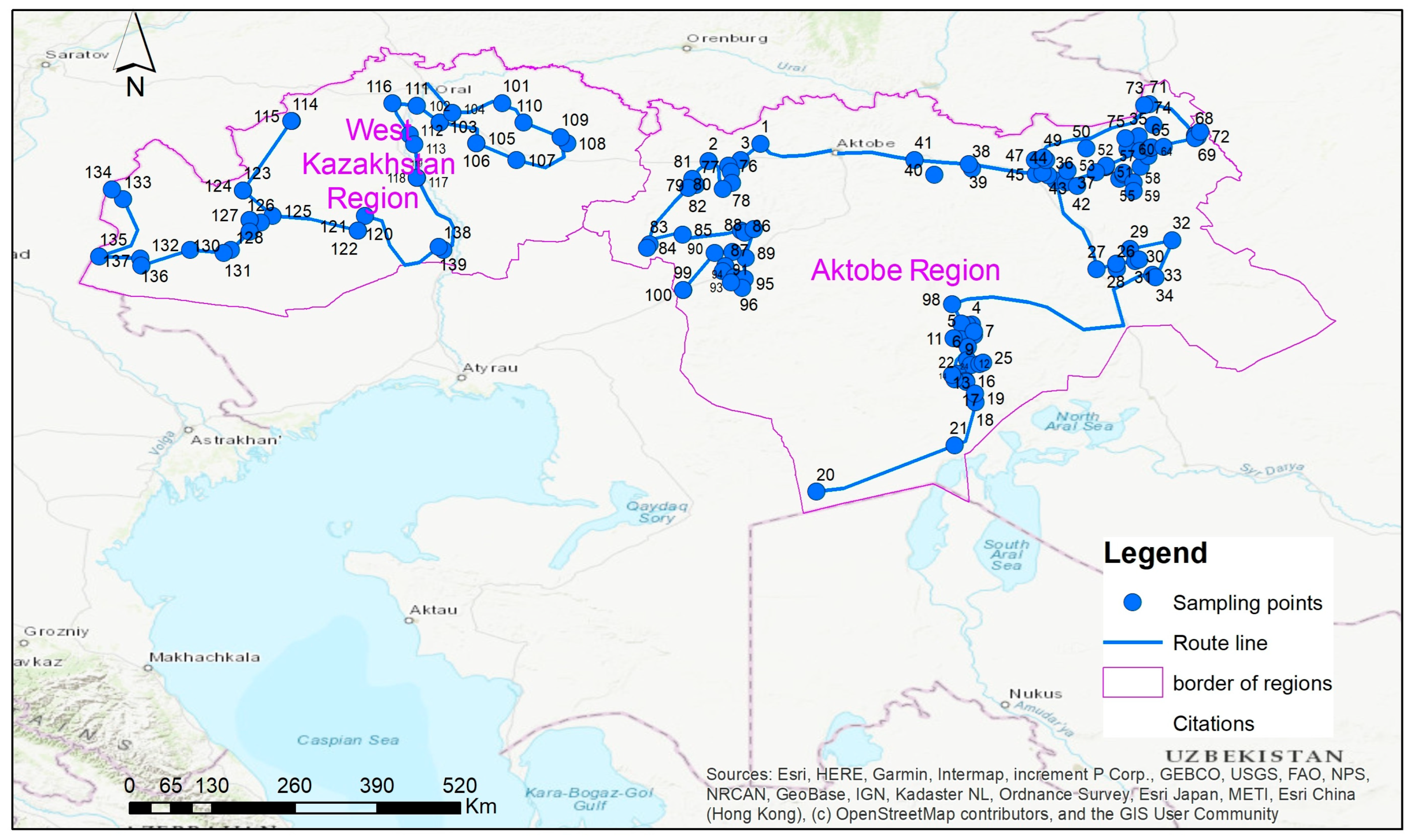
The hydrogeological framework of the study area encompasses multiple second-order basins of the Pre-Caspian and Ural-Mugalzhar artesian systems. The WKR is underlain by the northern Pre-Caspian Basin, characterised by widespread salt-dome tectonics and thick sequences of marine Pliocene–Quaternary sediments. The Aktobe Region spans the Zhemsky, Dongyztau-Predmugalzhar, Shalkar, and North-Usturt second-order basins, with a complex structural and lithological mosaic ranging from Quaternary alluvial sands to Cretaceous, Jurassic, and Triassic sedimentary and crystalline-basement aquifer systems. The location of the study area, groundwater sampling points, and principal hydrogeological basins are shown in
Figure 1.
Geological and Hydrogeological Setting
The stratigraphic sequence underlying the study area spans from Quaternary alluvial and aeolian deposits at the surface through Neogene, Palaeogene, and Cretaceous (including the Alb-Cenomanian stage) sedimentary formations, to Jurassic–Triassic continental deposits and the Pre-Palaeozoic crystalline basement. Each major stratigraphic unit hosts one or more aquifer horizons with distinct hydrochemical and hydraulic characteristics. The Quaternary alluvial aquifers, accessed by the shallow shaft wells that are the focus of this study, are unconfined, highly vulnerable to surface contamination, and exhibit variable salinity depending on local geology. The deeper Cretaceous (Alb-Cenomanian) and Jurassic–Triassic horizons are confined artesian aquifers that offer higher yields and better water quality but require borehole drilling. The geological structure is further complicated by widespread Permo-Triassic salt-dome tectonics in the Pre-Caspian lowland, which locally elevates groundwater salinity even at shallow depths.
2.2. Field Survey Design
Regional field expeditions were carried out during May–July 2025 by two dedicated hydrogeological teams operating simultaneously across the WKR and Aktobe Region. Prior to fieldwork, pre-field-stage preparation was completed: consolidated registers of previously documented wells and self-flowing boreholes were assembled from state geological fund archives, and preliminary route-survey maps were compiled for each administrative region.
2.2.1. Route Survey and Spatial Coverage
In the Aktobe Region, field surveys covered 5800 km of routes across the Aitikebi, Alga, Baigani, Kobda, Martuk, Mugalzhar, and Temir administrative districts. In the WKR, routes totalled 5382 km across the Kaztal, Zhympity, Tereñqudyq, Taipak, Kaztalovka, Saikhyn, and Aizhyn districts. Route types were classified as asphalted road (50%), unpaved steppe track (40%), and marshy or low-lying terrain (5% each) in the WKR; distribution was similar in the Aktobe Region. All routes were designed to maximise spatial coverage of active pastureland watering points, including seasonal (spring–summer and autumn–winter) grazing areas.
2.2.2. Watering-Point Inspection and Documentation
At each inspected object, the following parameters were recorded in a standardised field log: geographic coordinates and absolute elevation (GPS devices, accuracy ≤ 5 m); type of water supply structure (shaft well, tubular borehole, spring, or open water body); depth to static water level (measured by electric contact level gauge or weighted tape); well/borehole depth and casing diameter; presence, type, and operational status of pumping equipment and water-storage reservoirs; technical condition category (operational, requires repair, non-operational/abandoned); and sanitary–ecological condition of the surrounding area (see
Table 1).
The technical condition of watering infrastructure was assessed using the following classification: (1) good/satisfactory—functional without additional intervention; (2) requires repair or partial reconstruction—lacking at least one essential equipment element; (3) non-operational—completely destroyed or permanently abandoned. This classification follows the methodology of the State Geological Fund of the Republic of Kazakhstan and KazNIIVKh (Kazakh Research Institute of Water Management).
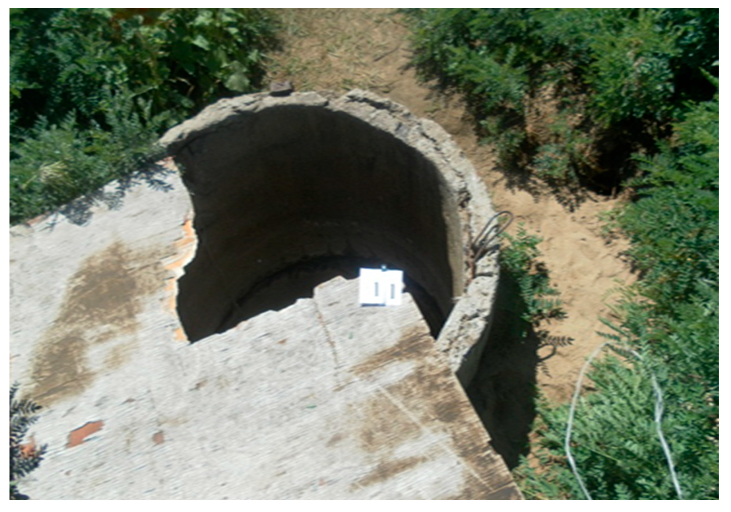
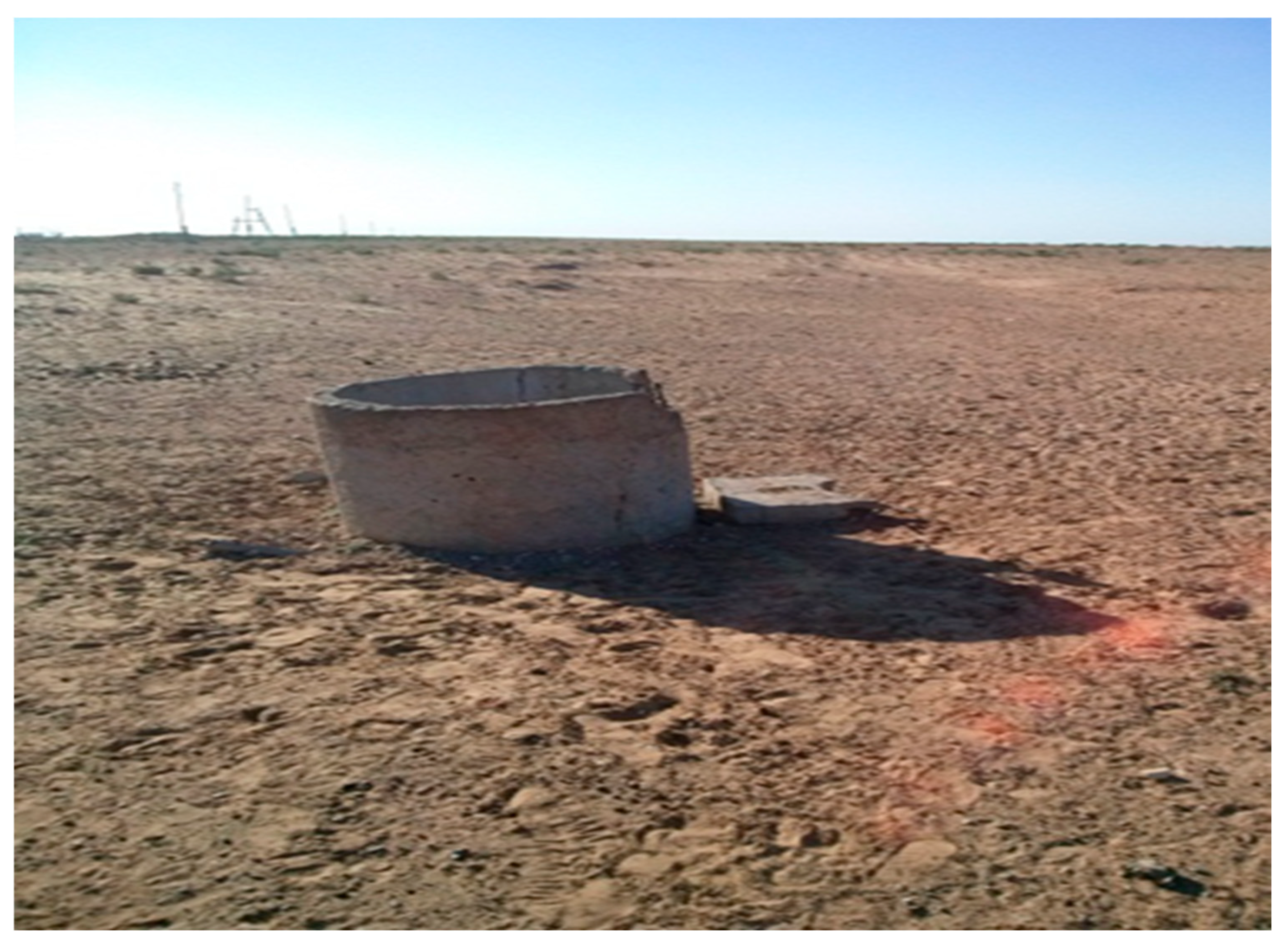
The shaft wells (shahtny kolodets) that constitute the primary groundwater access points in the study area are hand-dug or machine-excavated vertical openings, typically 1–2 m in diameter and 2–20 m deep, lined with concrete rings or stone masonry. In their original design, these wells were equipped with a concrete apron around the wellhead, a lockable metal or wooden cover, and a perimeter fence to prevent livestock from approaching the well opening. However, field inspection revealed that the vast majority of wells in both regions have lost these protective elements: covers were absent at over 80% of sites, concrete aprons were destroyed or absent at over 70%, and perimeter fences were absent at over 90%. As a result, livestock routinely congregate directly at the well opening, and animal waste accumulates within the immediate vicinity of the wellhead. Under these conditions, surface runoff carrying dissolved nitrate from decomposing manure has direct access to the water table through the unprotected annular space between the well lining and the surrounding soil—a short-circuit pathway that bypasses the natural attenuation capacity of the unsaturated zone. Field photographs illustrating typical well conditions are provided in
Figure A1 and
Figure A2 (
Appendix B).
2.3. Groundwater Sampling Protocol
Groundwater samples were collected from shaft wells (shahtny kolodets), self-flowing boreholes, pump-equipped boreholes, and springs. Sampling was performed in accordance with national groundwater sampling standards [
36,
37], which are harmonised with international protocols [
38].
For shaft wells, pre-sampling pumping was performed for a minimum of 5–10 min until field-measured TDS (electrical conductivity) stabilised, ensuring that stagnant surface water was fully purged. For self-flowing boreholes, samples were collected directly from the discharge point after at least 2 min of free flow. For pump-equipped boreholes, sampling was performed at the pump outlet after purging.
The samples were collected in polyethylene (HDPE) and glass containers of 1.0–2.0 L capacity, pre-rinsed three times with the sample water. Containers for heavy metal analysis were acidified with HNO
3 to pH < 2 and kept separate from other sub-samples. All containers were labelled, sealed, stored in portable coolers at 4 °C, and transported to the laboratory within 24–48 h of collection. A total of 139 samples were collected across the study area (100 from the Aktobe Region; 39 from the WKR) during the period May–June 2025. Individual sample locations, dates, and complete physicochemical analyses are compiled in
Table A1 (
Appendix A).
2.4. Laboratory Analysis
The analytical suite comprised 25 physicochemical parameters covering major ion chemistry, sanitary–chemical indicators, and trace contaminants (see
Appendix A,
Table A2 for the full parameter list with corresponding certified analytical methods). All the analyses were performed at the accredited Laboratory of Chemical Analytical Research of the U.M. Akhmedsafin Institute of Hydrogeology and Geoecology (Accreditation Certificate No. KZ.T.02.0782).
2.5. Hydrochemical Data Processing and Classification
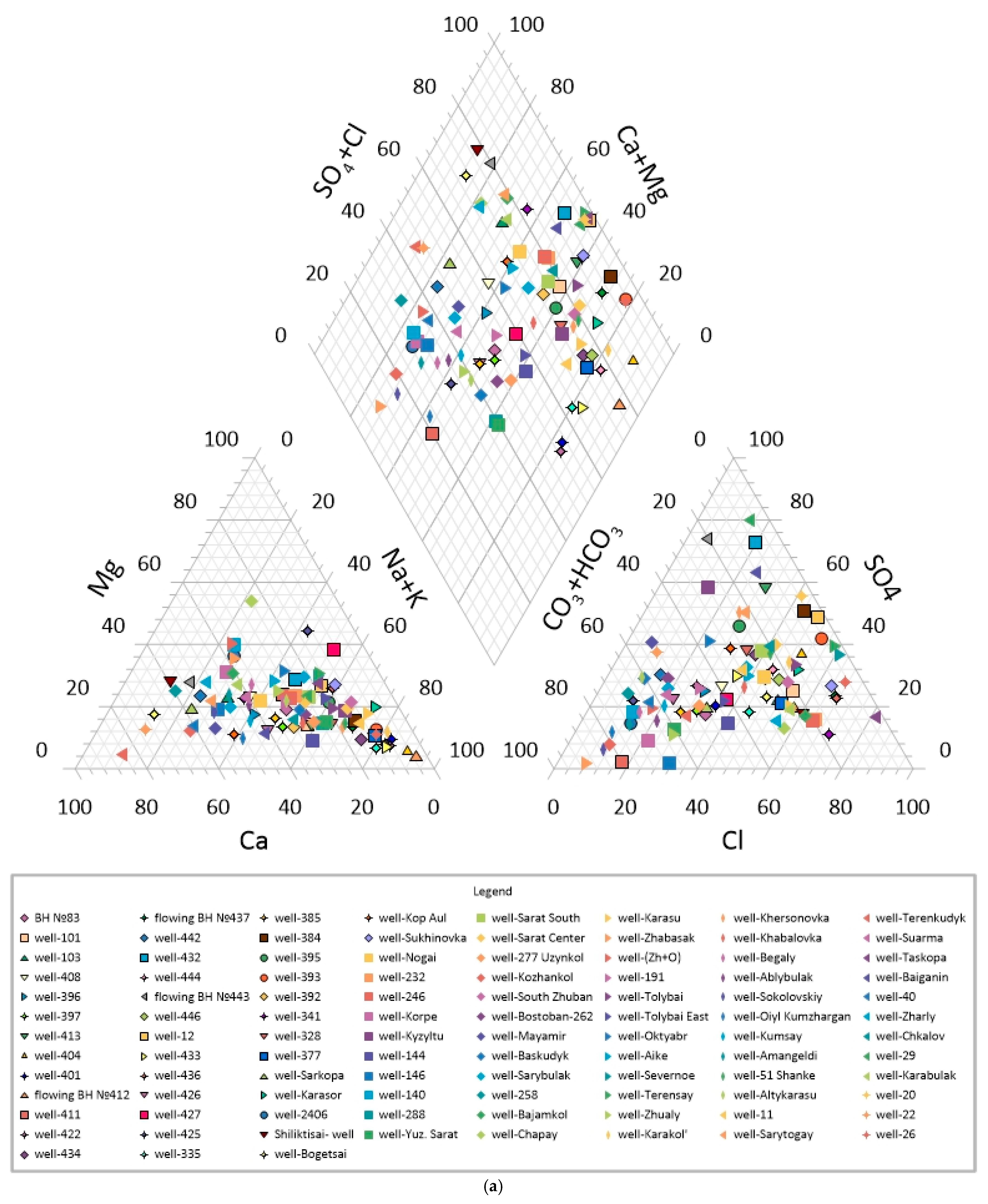
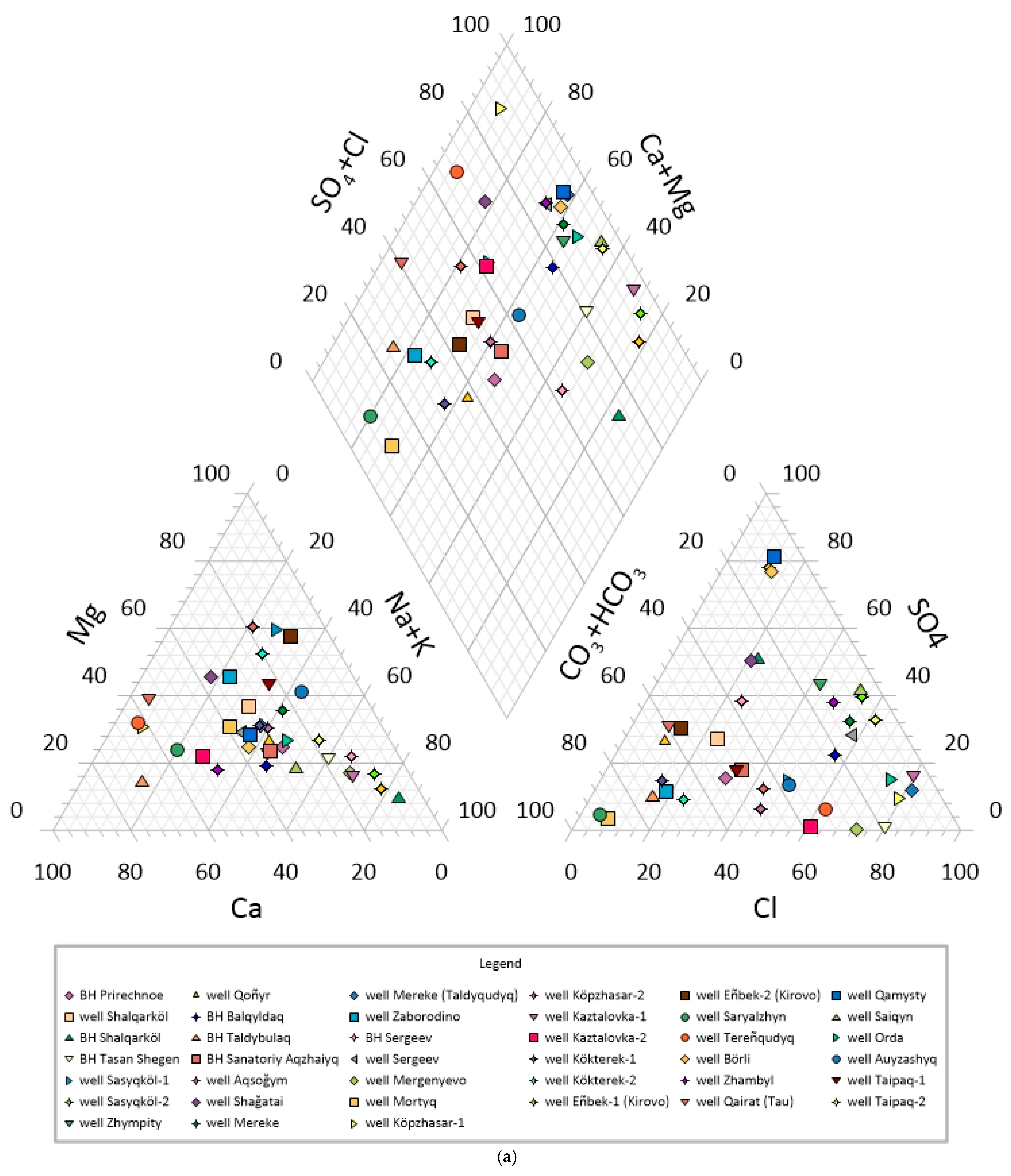
Hydrochemical analysis, graphical classification, and water-type assignment were performed using AquaChem 11 (Waterloo Hydrogeologic, Waterloo, ON, Canada). The following analytical tools were applied:
Piper trilinear diagrams—to classify the dominant cation–anion assemblage and identify major hydrochemical facies (HCO3-Ca-Mg, Cl-SO4-Na, mixed types, etc.);
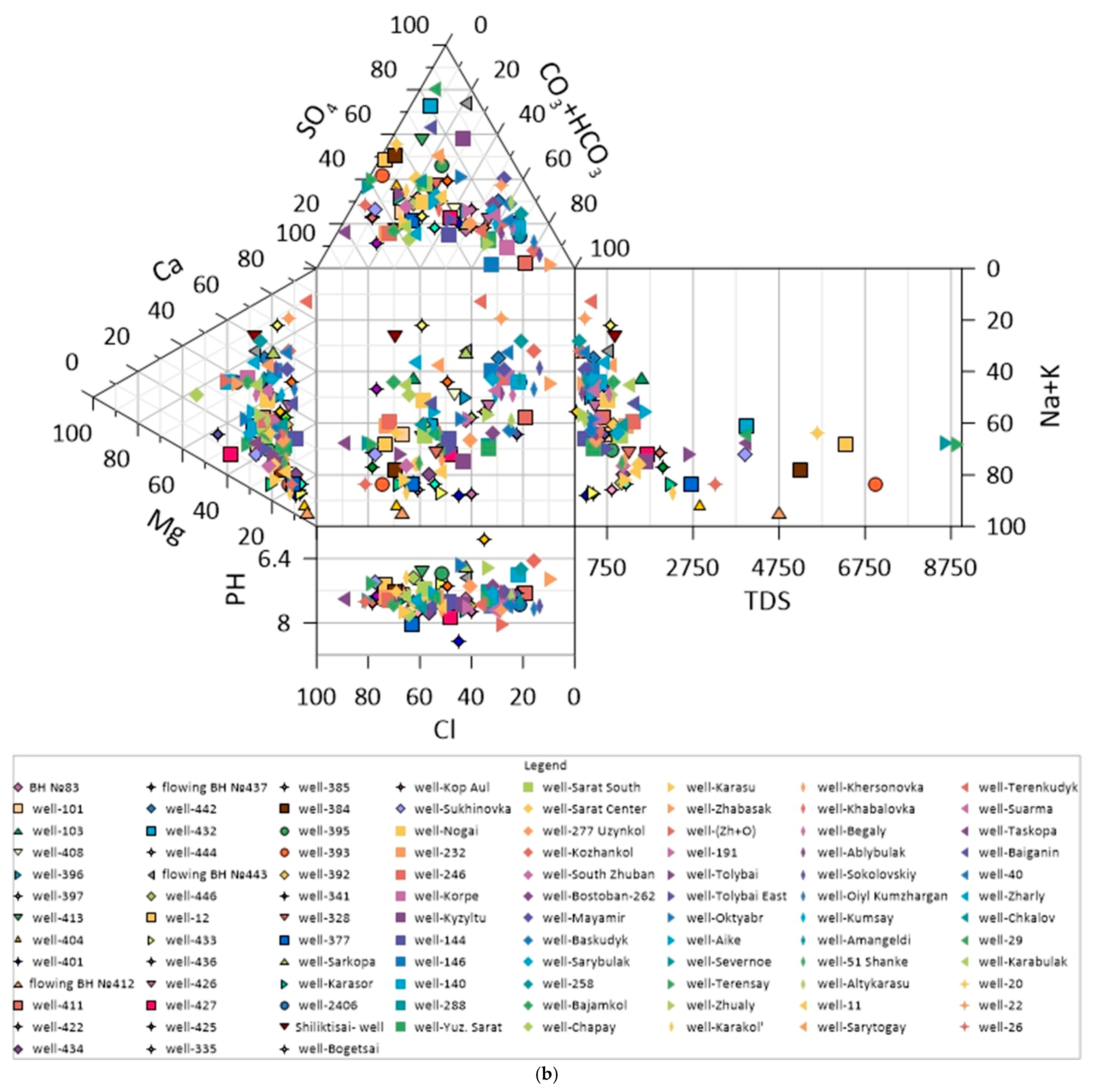
Durov diagrams—to display major ion composition as a function of TDS and pH, and to identify hydrochemical evolution trends (evaporative concentration, ion exchange, carbonate dissolution);
Descriptive statistics—minimum, maximum, arithmetic mean, and standard deviation (SD) computed for all 25 analytical parameters, stratified by administrative Region;
Charge balance error (CBE) calculated for each sample; samples with |CBE| > 10% were flagged for data quality review and, where necessary, excluded from statistical summaries.
The geographic coordinates of all 139 sampling points were recorded by GPS (accuracy ≤ 5 m) and compiled in ArcGIS 10.8 (Esri, Redlands, CA, USA). The spatial distribution of sampling locations is shown in
Figure 1. Continuous spatial interpolation methods (e.g., Inverse Distance Weighting, kriging) were not applied, because the route-based sampling design produces a linear, non-uniform point distribution that does not satisfy the spatial coverage and autocorrelation requirements of standard geostatistical algorithms. Instead, the spatial analysis in this study relies on the attribution of hydrochemical results to specific administrative districts and hydrogeological basins, with the complete georeferenced dataset provided in
Table A1 (
Appendix A) to enable independent spatial analysis by interested readers.
2.6. Assessment of Prospective Aquifer Horizons
Prospective aquifer horizons for pasture watering development were identified by integrating three categories of data: national-scale hydrogeological compilations, field measurements from the present survey, and the hydrochemical dataset generated in this study.
The principal national-scale sources were the Atlas of Hydrogeological Maps of the Republic of Kazakhstan (scale 1:2,500,000) [
34], which provides estimates of predictive exploitable groundwater resources classified by salinity (TDS < 1, 1–3, and 3–10 g/L) and maps of natural groundwater recharge rates per unit area (L s
−1 km
−2, hereafter referred to as the recharge rate module), and the State Register of Groundwater Deposits and Resources of the Republic of Kazakhstan [
39], which documents 1237 explored groundwater deposits across the study area. These compilations were supplemented by published hydrogeological exploration reports for the Pre-Caspian and Ural-Mugalzhar basins [
22,
40].
Field data collected during the present survey—including static water level, borehole depth, and measured yield at all inspected objects—and the results of the hydrochemical analysis of 139 groundwater samples provided site-specific ground-truthing of the national-scale resource estimates.
Prospective aquifer horizons were assessed against two categories of criteria. The hydrogeological suitability criteria require: (i) groundwater salinity not exceeding 3.0 g/L TDS, suitable for livestock consumption without desalination; and (ii) achievable well or borehole yield of at least 0.1 L/s, sufficient to sustain a minimum-capacity watering point.
Predictive exploitable groundwater resources for horizons meeting these criteria were compiled from the national Atlas dataset [
40] and reported in m
3/s and km
3/yr, stratified by salinity class (TDS < 1.0, 1.0–3.0, and 3.0–10.0 g/L) and by region. Natural groundwater recharge rates (L s
−1 km
−2) were calculated by GIS-based spatial analysis within pastoral-area polygon boundaries derived from the Ministry of Agriculture land cadastre (2023).
2.7. Livestock Water Demand Calculation
Current (2023 year) and projected (2050 year) daily water demand for livestock watering was calculated for four livestock species groups present on regional pasturelands. Livestock census data were obtained from official reports of district and region agricultural management departments (akimats) for the reference year 2023. Prescribed daily water consumption standards (L/head/day) were adopted from the national regulatory document ‘Mean Daily Water Consumption Standards by Livestock Species’, selecting the highest prescribed consumption rate among sub-categories within each species group (e.g., lactating cows rather than dry cows) to ensure the demand estimate captures peak daily requirements (See
Table 2).
Total daily water demand (m3/day) per region was obtained by summing the products of livestock headcount and the corresponding daily norm for each species group. Prospective water demand projections to 2050 were derived from three growth scenarios (baseline, conservative, accelerated) fitted to livestock census dynamics for the period 2015–2025, with projections applying the fitted annual growth rates for cattle and small ruminants to the 2023 base populations. Scenario projections were compiled for the WKR (target 2050: 500,000 cattle; 1,000,000 small ruminants; demand 26,000 m3/day) and the Aktobe Region (target 2050: 450,000 cattle; 800,000 small ruminants; demand 22,800 m3/day), following the programme targets of the Kazakhstan Agricultural Development Concept 2021–2030.
2.8. GIS Database and Geoinformation-Analytical System
An integrated geoinformation database and GIS database was developed in ArcGIS 10.8 (Esri) for systematic storage, spatial integration, and visualisation of all hydrogeological, hydrochemical, and pastoral land datasets. All spatial data are georeferenced to WGS 84, projected in UTM Zones 42N–43N. The database was structured according to an object-oriented architecture enabling scalable addition of new data layers and thematic modules.
The GIS database comprises six functional data blocks:
Administrative boundaries—polygon layers for regions, districts, and settlements; point layers for urban and rural localities.
Water supply infrastructure—point objects for all inspected shaft wells, boreholes, and springs with linked attribute tables containing GPS coordinates, absolute elevation, depth, static water level, TDS (field measurement), equipment type, and technical condition class; linked to hydrochemical analysis results (
Table A1).
Pastoral land resources—vectorised polygon layers of pasture-type distribution (based on Ministry of Agriculture land cadastre, 2023), pasture condition classes, and seasonal grazing areas.
Groundwater deposits—point and polygon layers for 1237 explored groundwater deposits (GWDs) classified by intended use, genetic type, and approved reserve category; attribute tables of exploitable reserve volumes by region and TDS class.
Hydrogeological maps—rasterised and vectorised hydrogeological maps at 1:2,500,000 scale (Atlas of Hydrogeological Maps of Kazakhstan), including aquifer boundaries, groundwater TDS contours, and natural resource modules.
Groundwater availability zoning—polygon layers classifying pasture territory into groundwater-availability zones (surplus, balanced, deficit) computed by GIS-overlay of predictive resource modules against calculated livestock water demand per unit pastoral area.
Thematic maps were produced at 1:1,000,000 and 1:2,500,000 scales using cartographic tools. Spatial analysis operations included polygon overlay, buffer analysis (radius-of-watering-influence calculation), and zonal statistics. The groundwater availability index (GAI) was computed as the ratio of predicted exploitable fresh groundwater resources (TDS < 3 g/L) per unit pasture area (L s−1 km−2) to the normative daily water demand density (m3 day−1 km−2) derived from livestock census data. GAI categories were defined as: surplus (GAI > 1.5), balanced (0.8–1.5), and deficit (GAI < 0.8).
2.9. Technical Condition Assessment of Watering Infrastructure
The technical state of all inspected water supply objects was assessed using a standardised inspection protocol derived from KazNIIVKh methodological guidelines for inventory of pasture watering infrastructure. For each object, the following attributes were recorded:
Borehole/well: depth (m); casing diameter (mm) (documented distribution: 108 mm, 150 mm, 219 mm, 326 mm); static water level depth (m); estimated yield (L/s); operational status of casing and wellhead.
Pumping equipment: type (submersible pump, ribbon/tape water-lifter, manual pump, or none); power source (mains, diesel/petrol generator, wind/solar-powered); operational status.
Water-storage reservoir: volume (m3), material (reinforced concrete, metal), lid/cover presence, structural integrity.
Watering trough: material (asbestos-cement pipe or metal pipe, Ø300–800 mm, length up to 20 m), support condition, surface condition.
Sanitary perimeter: enclosure presence, cleanliness, risk of cross-contamination from livestock pens or waste storage.
Technical condition was scored as: operational (grade 1); requires current or capital repair (grade 2); non-operational/abandoned (grade 3, recommended for decommissioning and replacement). The threshold criterion for replacement was the simultaneous absence of ≥2 essential equipment elements in combination with structural damage to the casing or wellhead.
2.10. Data Quality Assurance and Ethical Compliance
Field measurement instruments (GPS devices, portable conductivity/TDS metres, level gauges) were calibrated before each expedition in accordance with manufacturer specifications. Laboratory analytical equipment was maintained and calibrated in accordance with the requirements of the Accreditation Certificate No. KZ.T.02.0782. All the water samples were analysed in duplicate; relative standard deviation (RSD) between duplicates was required to be <5% for major ions and <10% for trace elements. Certified reference standards were included in each analytical batch.
Ionic charge balance error (CBE) was computed for all samples as CBE = (Σcations − Σanions)/(Σcations + Σanions) × 100%. Samples with |CBE| > 10% were excluded from statistical summaries (this affected <3% of samples). Annual inter-laboratory comparison proficiency testing was conducted by a certified provider in accordance with ISO/IEC 17043:2010.
4. Discussion
4.1. Principal Findings in Context
This study presents the first systematic field-based hydrochemical characterisation of pasture livestock watering sources in the WKR and the Aktobe Region in over 40 years. The results (
Table 3,
Table 4 and
Table 5) reveal a dual groundwater quality landscape shaped by geological inheritance, aridity, and localised anthropogenic pressures, and define a paradox of pasture water management: adequate fresh groundwater resources (approximately 80% of samples with TDS < 3.0 g/L) exist beneath pasturelands that cannot be grazed because 51–75% of inspected watering infrastructure is non-operational and 23–36% of sources are nitrate-contaminated. The fundamental constraint identified by this study is therefore not a resource deficit but an infrastructure delivery deficit. The predictive exploitable fresh groundwater resources of both regions collectively exceed the current livestock water demand (
Table 9), confirming that the physical resource base is more than sufficient to support all current and projected livestock populations. The critical bottleneck lies in the capture, distribution, and maintenance of water supply infrastructure, the system that converts a subsurface resource into water at the point of livestock consumption.
4.2. Hydrogeochemical Processes Controlling Groundwater Quality
4.2.1. Evaporative Concentration and Salt-Dome Dissolution—The Primary Salinisation Driver
The dominant hydrogeochemical process controlling TDS and major ion chemistry in both regions is evaporative concentration of shallow groundwater, superimposed on dissolution of halite and gypsum/anhydrite from Permo-Triassic and Pliocene–Quaternary salt-bearing sequences [
18,
19]. This interpretation is supported by three lines of evidence.
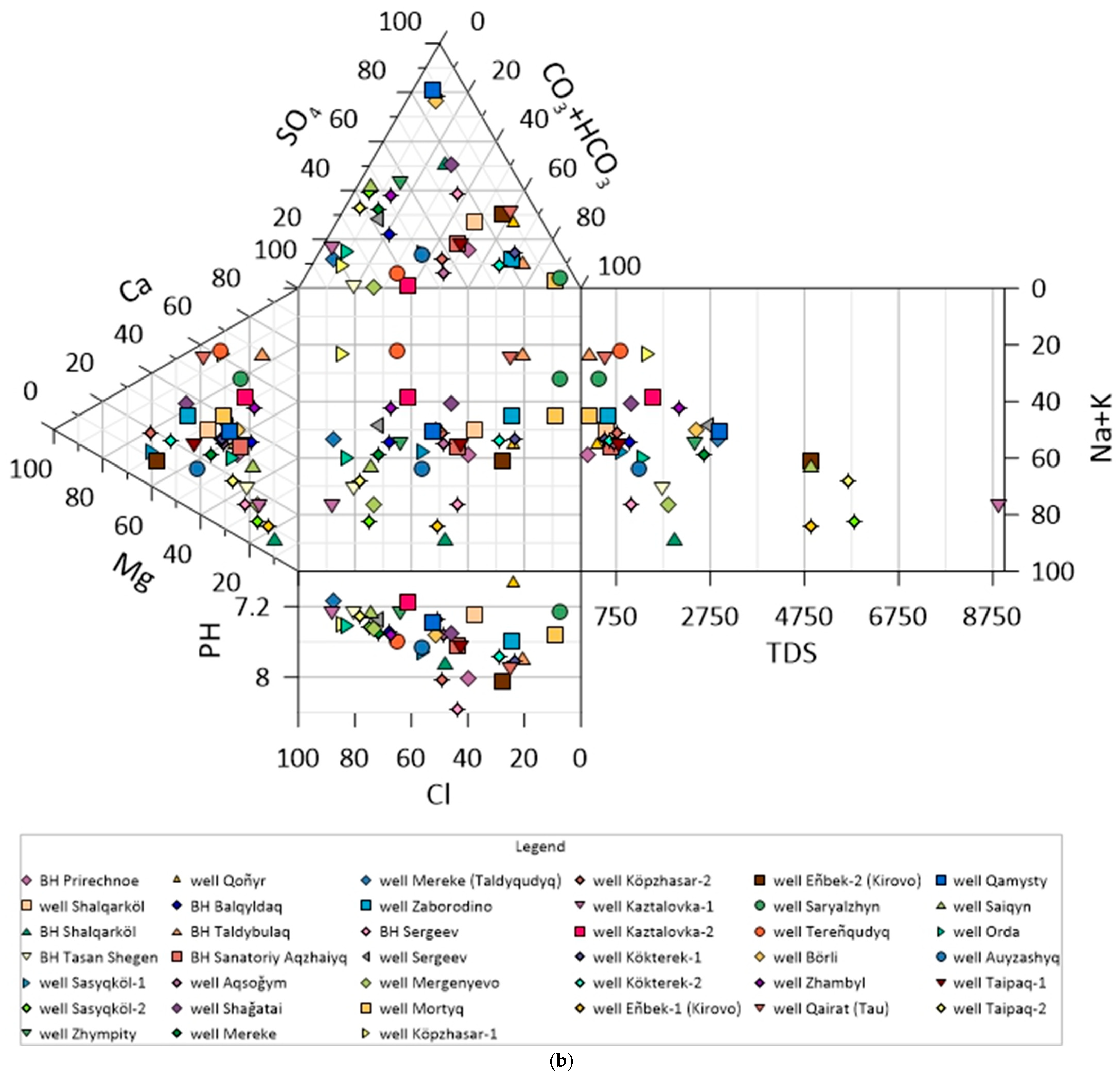
First, the Piper diagrams (
Figure 2a and
Figure 3a) show that samples classified as Na–Cl–SO
4 water type by their relative ionic composition occupy a distinct field in the lower-left quadrant of the diamond plot, indicating the dominance of sodium among cations and chloride–sulphate among anions. It should be noted that the Piper diagram displays only relative ion proportions and does not distinguish samples by absolute TDS; the association between the Na–Cl–SO
4 water type and high TDS values is confirmed independently by the analytical data (
Table 3 and
Table 4), which show that all samples with TDS > 3.0 g/L fall within this hydrochemical facies. The Durov diagrams (
Figure 2b and
Figure 3b), which incorporate TDS on the marginal axis, provide direct visual confirmation of this relationship: Na–Cl–SO
4 samples cluster in the high-TDS field (>2000 mg/L), while HCO
3–Ca–Mg samples cluster in the low-TDS field (<1000 mg/L).
Second, the Cl/Na molar ratio approaches 1.0 at the most saline sites, which is diagnostic of halite dissolution as the controlling geochemical process. Third, brackish samples from the Kobda district (the Aktobe Region) and the Kaztalovka area (the WKR) display Ca2+ + Mg2+ excess over HCO3− + SO42−, reflecting gypsum dissolution and reverse cation exchange (Ca → Na) on clay minerals in the Neogene–Quaternary argillaceous sequences.
Together, these lines of evidence trace a clear hydrogeochemical evolution trend visible on the Durov diagrams: fresh HCO3–Ca–Mg waters from recharge zones (upper-left field) evolve through progressively increasing TDS toward Cl–SO4–Na waters in discharge and evaporation zones (lower-right field) without a significant shift in pH. This trajectory corresponds to the classic Chebotarev sequence for arid-zone artesian basins, driven by lateral groundwater flow from recharge areas (the northern Aktobe Region, the Syrtovskoye basin in the WKR) through intermediate zones toward topographically low discharge areas (the Pre-Caspian lowland, the Kobda salt-dome zone, Kaztalovka).
Salt-dome tectonics in the northern Kobda district create anomalously high local TDS gradients: the transition from fresh HCO
3-Ca-Mg to highly saline Cl-SO
4-Na waters (
Table 3) occurs over horizontal distances of <20 km, consistent with observations from the eastern Pre-Caspian Basin and the Ustyurt Plateau [
22]. Adenova et al. [
22] similarly reported TDS ranging from 0.5 to >10 g/L in western Kazakhstan, with hydrocarbon-related contamination as an additional concern. The practical implication is that new watering points in the Kobda district should preferentially target deeper artesian horizons (Alb-Cenomanian, Jurassic–Triassic) rather than shallow shaft-well depths.
4.2.2. Carbonate Weathering and Recharge-Zone Chemistry
Fresh HCO3-Ca-Mg waters in the Predmugalzhar, Dongyztau, and Syrtovskoye basins are geochemically controlled by open-system carbonate dissolution: infiltrating precipitation charged with soil CO2 dissolves calcite and dolomite, producing Ca2+- and Mg2+-rich, HCO3−-dominant groundwater at pH 7.0–8.0.
These low-TDS waters recharge through alluvial gravels derived predominantly from carbonate-bearing (limestone and dolomite) formations of the Ural and Mugalzhar fold belts. Despite the short rock–water contact time, carbonate dissolution is sufficiently rapid to impart a Ca-Mg-HCO3 hydrochemical signature to the recharge waters.
The moderate hardness in many HCO3-Ca-Mg samples (5–15 meq/L) is largely geogenic, reflecting dolomite-dominated lithology in the Jurassic–Triassic and Palaeogene formations of the study area. This hardness, while exceeding the aesthetic guideline of 6 meq/L for drinking water, does not constitute a livestock health risk at concentrations below ~25 meq/L; cattle, horses, and sheep tolerate hardness to at least 30 meq/L without measurable productivity losses. Only the 14 samples with hardness > 25 meq/L, concentrated at high-TDS Cl-SO4-Na sites, approach the threshold associated with reduced magnesium bioavailability and hypomagnesaemia risk in ruminants.
4.2.3. Fluoride Enrichment—Geogenic Source, Aktobe Region
Elevated fluoride concentrations (exceeding the WHO guideline of 1.5 mg/L) were detected in 12 of 100 samples (12%) from the Aktobe Region, concentrated in the Aitikebi and Kobda districts where the shallow aquifer is hosted within Neogene sandy deposits of the Shalkar Basin and adjacent Palaeogene horizons.
Fluoride enrichment in arid-zone Central Asian groundwater is a well-documented geogenic phenomenon controlled by three interrelated processes. The primary source of dissolved fluoride is the weathering and dissolution of fluorite (CaF
2) and, to a lesser extent, fluorapatite (Ca
5(PO
4)
3F) disseminated within the Neogene and Palaeogene host sediments. Structurally bound fluoride in phyllosilicates (biotite, muscovite) and devitrifying volcanic glass in Palaeogene tuff layers provide additional, slower-release geogenic inputs. This initial release is amplified by evaporative concentration, which progressively increases fluoride levels as water is lost to evapotranspiration under the arid conditions of the study area. A third mechanism, competitive desorption, operates in alkaline groundwater (pH > 7.5), where hydroxyl ions displace fluoride adsorbed on the surfaces of clay minerals and iron oxyhydroxides, releasing additional F
− into the solution [
29,
30]. Comparable geogenic fluoride enrichment through analogous mineral-weathering pathways has been documented in surface waters draining volcanic-sedimentary terrains in northeastern Turkey [
31].
The Durov diagram for the Aktobe Region (
Figure 2b) places the fluoride-enriched samples in the high-pH, moderate-Na field, which is consistent with this desorption mechanism being active at the affected sites.
The maximum fluoride concentration of 6.3 mg/L, recorded at ShK-Tolybai Vostok in the Aitikebi district, exceeds the chronic fluorosis risk threshold for cattle (>5 mg/L) and represents a direct livestock health hazard. Prolonged consumption of water at this concentration causes dental and skeletal fluorosis in both cattle and sheep, leading to reduced feed intake, lameness, and measurable declines in productivity. The consistent spatial clustering of elevated fluoride within the Shalkar Basin confirms the Neogene formation as the primary geogenic source and indicates that shallow shaft wells in this area should not be used for livestock watering without prior defluoridation treatment.
Comparable geogenic fluoride enrichment has been documented in arid-zone aquifers of southeastern Algeria, where Masmoudi et al. [
29] reported F
− concentrations up to 3.2 mg/L in Cretaceous sedimentary aquifers under semi-arid conditions. Yang et al. [
30] identified probabilistic health risks from fluoride in shallow groundwater of northern China’s irrigation areas, with maximum F
− of 4.8 mg/L associated with alkaline Na-HCO
3 water types—a geochemical association consistent with the high-pH, Na-enriched samples observed in the present study at fluoride-affected sites in the Shalkar Basin.
4.3. The Infrastructure–Resource Paradox: Adequate Groundwater, Failed Delivery
The most significant practical finding is the mismatch between resource endowment and infrastructure capacity. As shown in
Table 8 and
Table 9, predictive exploitable fresh-water resources exceed the combined current livestock water demand by a factor of >160, and even accelerated 2050 growth scenarios would require less than 2% of the available resource. This finding aligns with previous assessments of Kazakhstan’s total groundwater potential (estimated 61–64 BCM/yr nationally, of which only ~25% is formally approved for use) and with the recognition that 56.5% of the national pasture area remains unused, a situation that reflects the absence of functional water supply infrastructure rather than groundwater resource scarcity.
The field survey quantified this infrastructure deficit precisely: 51–75% of all inspected water supply objects are non-operational or requiring major capital repair. This confirms and updates earlier estimates of 50–73% infrastructure disrepair from region-level inventories. The implications for resource utilisation are stark: even if only the currently operational fraction of wells were fully functional and properly maintained, pastoral watering coverage would increase substantially—because the resource potential beneath each watering point typically far exceeds the current demand. The dominant infrastructure failure modes identified in this survey (exceedance of design service life, absence of maintenance, equipment removal) are all addressable at relatively low unit cost compared to the economic returns from restored pasture productivity.
Economic analysis demonstrates that the levelised cost of water (LCW—defined as the total annualised capital and operating cost divided by the annual volume of water produced) from rehabilitated or new boreholes in the study area ranges from 1278 to 2891 KZT/m3 (KZT—Kazakhstani tenge; approximately USD 2.6–6.1 $/m3 at 2025 exchange rates), depending on scenario assumptions. At the baseline scenario (1923 KZT/m3), operating a 1000-head sheep/cattle unit on an improved watered pasture generates 8–16 million KZT/yr additional income compared to an unwatered pasture, which more than covers the annualised capital cost at herds > 700 head. The economic case for watering infrastructure investment is therefore strong at realistic stocking densities, though public subsidy remains essential for remote single-family operations in the pessimistic scenario.
4.4. Climate Change Implications for Groundwater Quality and Pasture Water Supply
Climate model projections for Kazakhstan indicate a significant increase in aridity across western Kazakhstan through 2050, characterised by: a 16% reduction in growing-season moisture supply; a 17% increase in the aridity index; a rise in mean annual temperature of 1.5–2.5 °C relative to the 1980–2010 baseline; and increased frequency of severe droughts. These trends have direct hydrogeological consequences for the study area:
Reduced groundwater recharge: As precipitation decreases and evapotranspiration increases, infiltration rates to unconfined shallow aquifers will decline, reducing natural flushing of nitrate and other contaminants. In arid conditions, groundwater residence time in shallow aquifers increases, intensifying evaporative concentration and elevating TDS even in currently fresh sources.
Increased livestock water demand: Higher ambient temperatures in arid summer conditions increase the daily stock water requirement of cattle by 15–25% and of sheep by 10–15% per 5 °C temperature increase above the thermoneutral zone (the ambient temperature range within which an animal does not need to expend additional energy for thermoregulation, typically 5–25 °C for cattle). By 2050, the projected additional demand due to climate-induced temperature rise alone could add 5000–8000 m3/day to the combined study-area demand—equivalent to a 12–19% increase above the 2023 baseline.
Increased overgrazing pressure near functional watering points: As more shallow wells fail and are not replaced, the remaining operational watering points will support higher stocking densities within their 5–10 km water access radius. This concentrates livestock waste near functional wells, accelerating nitrate contamination of the very sources that remain accessible.
Pasture degradation feedback: The loss of 15–49% of rangeland productivity projected for semi-arid Kazakhstan by 2050 will increase pressure to expand grazing into remote, currently underutilised areas—which are precisely the areas where watering infrastructure is largely absent. This creates a strong positive feedback: climate-driven pasture degradation near settlements incentivises movement to remote pastures, which requires new watering infrastructure investment, which in turn is the enabling condition for realising Kazakhstan’s 2050 livestock development targets.
It must be stressed that projected climate change does not threaten the adequacy of the groundwater resource base itself: even under the most aggressive demand growth scenario for 2050, total livestock water requirements would consume less than 2% of the available fresh groundwater. Rather, climate-driven increases in daily water consumption per animal, combined with accelerated degradation of the remaining functional infrastructure through more frequent drought and extreme heat events, will widen the disparity between the water that exists in the subsurface and the water that is actually delivered to livestock through operational watering points. In practical terms, higher temperatures will increase the urgency and scale of infrastructure rehabilitation, not the need for new groundwater exploration.
It is important to recognise a limitation of the present study in the context of climate change: the 2025 field campaign provides a single-season spatial snapshot of groundwater chemistry, not a time series. A one-time sampling campaign, regardless of its spatial coverage, cannot detect temporal trends in groundwater quality or distinguish climate-driven changes from natural inter-annual variability.
Detecting climate-induced changes in groundwater quality (such as progressive salinisation of shallow aquifers due to declining recharge, or increasing nitrate concentrations due to reduced dilution) would require a dedicated long-term monitoring programme with consistent sampling methodology applied over at least 10–15 years at a network of representative sites. Even annual sampling at a subset of wells would require many years of data accumulation before statistically meaningful trends could be distinguished from seasonal and inter-annual variability. The establishment of such a monitoring network, building on the georeferenced baseline dataset created in this study, is therefore a priority recommendation for future work.
4.5. Desalination and Treatment Technologies for Marginal-Quality Sources
For the approximately 20% of samples in both regions with TDS > 3 g/L, and particularly for the 10% with TDS > 5 g/L, groundwater use for livestock watering requires desalination. Three desalination and treatment technologies were evaluated for their applicability to the specific conditions of western Kazakhstan’s pastoral water supply, considering the constraints of remote location, absence of grid electricity at most sites, and the differing water quality requirements for livestock watering versus human drinking water. The selection of technology at any given site depends primarily on the TDS of the source water and the intended end use. The study identifies two technology options appropriate for the conditions of western Kazakhstan:
For the most highly saline sources (TDS > 8 g/L, affecting three of 139 samples in this study), reverse osmosis (RO) is the recommended treatment. RO achieves greater than 99% salt rejection but is more energy-intensive than ED and requires pre-treatment (sand filtration, cartridge filtration) to protect the membranes from turbidity-related fouling. RO also generates a high-TDS brine concentrate (20–40% of the feed volume) that requires controlled disposal, which is a particularly important consideration in the ecologically sensitive Pre-Caspian lowland.
A second technology option—solar-trough evaporation distillers—addresses a different but closely related challenge. At many remote pasture sites in the study area, groundwater with TDS of 3–5 g/L remains usable for livestock (cattle tolerate up to 5 g/L without productivity losses) but is unsuitable for human consumption, which requires TDS below 1.0 g/L under WHO and Kazakh national drinking water standards. The pastoral workers and their families who manage livestock at these remote seasonal camps therefore lack access to safe drinking water, even though the livestock water supply is technically adequate. Solar-trough distillers produce small volumes of purified water (typically 2.5–3 L per m2 of collector area per day) that are wholly insufficient for livestock watering but can meet the drinking and cooking water needs of 2–4 persons. Deploying these low-cost, energy-autonomous units at remote watering points would thus simultaneously resolve two distinct water access problems: the livestock watering deficit (met by the untreated groundwater source) and the rural drinking water deficit for pastoral communities, contributing to the objectives of United Nations Sustainable Development Goal 6 (SDG-6: “Ensure availability and sustainable management of water and sanitation for all”).
For the 33–36% of sites where nitrate contamination is the sole or primary water quality problem and TDS is otherwise acceptable for livestock use, desalination is not required. At these sites, the intervention strategy focuses on eliminating the contamination source and preventing further contaminant ingress, rather than on treating the water itself.
The first component of this strategy is wellhead protection, which involves four measures: (i) construction of a perimeter fence (minimum 50 m radius) to exclude livestock from the immediate vicinity of the well; (ii) installation or repair of a concrete apron around the wellhead to prevent direct infiltration of surface runoff into the well; (iii) sealing of the annular gap between the concrete ring lining of the shaft well and the surrounding undisturbed soil, to eliminate the preferential vertical pathway through which contaminated surface water currently bypasses the unsaturated zone; and (iv) relocation of the nearest livestock pen or manure storage to a distance of at least 100 m from the wellhead, thereby removing the primary nitrogen source from the well’s immediate catchment area. It should be noted that the shaft wells in the study area are lined with concrete rings that function as the structural casing; the term “grouting” refers specifically to sealing the annular space around this lining, not to installing new casing.
The second component is natural attenuation—the ensemble of biogeochemical and physical processes that reduce nitrate concentrations in groundwater after the contamination source has been removed. In the aerobic, shallow unconfined aquifers of the study area, the dominant attenuation mechanisms are expected to be dilution by uncontaminated recharge (rainfall infiltration replacing contaminated pore water over successive recharge cycles) and, to a lesser extent, aerobic denitrification by indigenous soil bacteria in the unsaturated zone. However, the timescale of nitrate recovery in groundwater is highly site-dependent and is controlled by several factors that vary across the study area: the thickness and permeability of the unsaturated zone, the annual recharge rate, the volume of nitrate stored in the soil profile above the water table, and the extent to which the contamination source is fully eliminated rather than merely reduced. Published studies in comparable shallow alluvial aquifer settings have reported nitrate concentration declines of 30–60% within 3–5 years following source removal where the unsaturated zone is thin (<5 m) and recharge rates are moderate [
42], but substantially longer recovery times (10–20 years) have been documented where thick unsaturated zones or low recharge rates slow the flushing process [
41].
Accordingly, we do not predict a specific recovery timeline for the contaminated sites in the study area. Instead, we recommend that post-intervention monitoring be initiated at all rehabilitated wellhead sites, with semi-annual nitrate sampling for a minimum of five years, to empirically assess the rate of water quality improvement and to determine whether additional intervention (such as active denitrification treatment) is necessary at sites where passive attenuation proves insufficient.
4.6. Towards an Integrated Decision Framework for Pasture Watering Infrastructure
The field survey results, hydrochemical dataset, resource assessment, and demand projections presented in this study provide the input layers for a multi-criteria spatial decision framework for pasture watering infrastructure investment.
4.6.1. Decision Criteria and GIS Data Layers
The GIS database assembled in this study (
Section 2.8) contains five categories of spatially referenced data that, when overlaid, define the decision space for each pasture management unit:
(i) Infrastructure condition and rehabilitation potential. The three-tier classification of all inspected watering points (operational/requires repair/non-operational) identifies sites where rehabilitation is feasible at 30–50% of the cost of equivalent new construction, versus sites that require complete replacement. Rehabilitation of Grade 2 (repairable) infrastructure should generally precede new construction, as it yields the fastest and most cost-effective expansion of watering coverage.
(ii) Groundwater quality and livestock suitability. The hydrochemical dataset (
Table 3,
Table 4,
Table 5 and
Table A1) identifies which sources are directly suitable for livestock watering (TDS < 3.0 g/L, NO
3− < 50 mg/L), which require only wellhead protection to address nitrate contamination (33–36% of samples), and which require desalination treatment (TDS > 5.0 g/L, approximately 10% of samples).
(iii) Aquifer yield and artesian conditions. The prospective aquifer horizon assessment (
Table 6 and
Table 7) identifies areas where self-flowing artesian conditions eliminate pumping costs entirely—a decisive economic advantage at remote sites. In the Aktobe Region, the Alb-Cenomanian horizon offers artesian heads of +10 to +30 m above ground level across the Predmugalzhar and Zhemsky basins; in the WKR, the Palaeogene–Upper Cretaceous horizon of the Syrtovskoye basin provides the highest yields (up to 15 L/s).
(iv) Renewable energy potential for pumping. Where artesian conditions are absent and pumping is required, the feasibility of solar-photovoltaic or wind-electric pumping systems determines whether a site can operate independently of diesel fuel supply. Solar pumping is viable throughout the study area (annual global horizontal irradiance 1400–1600 kWh/m2), while wind-electric systems are particularly suited to the high-wind corridors of the northern WKR and the northern Aktobe Region.
(v) Contamination risk and wellhead protection requirements. The spatial correlation between nitrate exceedances and proximity to livestock facilities (
Section 3.2.5) allows identification of sites where wellhead protection alone can restore water quality, versus sites where the contamination source cannot be relocated and alternative water sources must be developed.
The overlay of these five layers within the GIS database enables classification of each pasture management unit into one of several intervention categories—for example, “rehabilitate existing infrastructure, no treatment needed,” “drill new borehole to artesian horizon, install solar pump,” or “install electrodialysis at existing high-TDS source”—rather than applying a uniform strategy across the entire study area.
4.6.2. Time-Staged Implementation
While the spatial decision framework determines where and what type of intervention is appropriate, the temporal sequencing of investments must also consider urgency and feasibility. Three time horizons are relevant.
In the immediate term, use of the eight confirmed extreme-nitrate sites (NO3− > 200 mg/L) should be suspended for watering young livestock (calves and lambs under 90 days) and pregnant animals until wellhead protection has been installed and water quality re-tested. In the short to medium term (1–10 years), wellhead protection should be implemented at all nitrate-contaminated sites with otherwise acceptable TDS, and electrodialysis units should be installed at the highest-TDS sites (5–10 g/L) in the Kobda district (the Aktobe Region) and Kaztalovka–Taipak area (the WKR) where deeper fresh-water horizons are not accessible. In the long term (to 2050), non-viable shallow saline shaft wells should be replaced by a hub-and-spoke delivery system, in which treated water from central boreholes is distributed to satellite watering points, combined with seasonal surface water impoundments in areas of concentrated runoff.
4.6.3. Monitoring Network
A standing hydrochemical monitoring network of 30–40 representative wells in each region, stratified by TDS class, aquifer type, and district, should be established and sampled at least annually. The GIS database developed in this programme provides the spatial framework for site selection. Integration of satellite-derived pasture condition indicators (such as NDVI for vegetation health and Sentinel-1 soil moisture for drought detection) into the monitoring system would enable early identification of pasture degradation hotspots and support the prioritisation of emergency water supply interventions. The ultimate objective is an operational decision-support platform linked to the livestock census and pasture cadastre, accessible to regional agricultural departments (akimats) for evidence-based management planning.
4.6.4. Factors Beyond the Scope of This Study
It must be acknowledged that a fully operational decision-support system for pasture watering investment would require additional data layers that lie outside the scope of this hydrogeological study. These include the livestock carrying capacity of each pasture management unit, distance to livestock markets and processing facilities, condition of transport infrastructure (roads, tracks), availability of labour and technical maintenance capacity at remote sites, and the socio-economic conditions of pastoral communities. These factors influence the economic viability and practical sustainability of watering infrastructure investments and should be integrated into the GIS framework as they become available from ongoing national land cadastre and agricultural census programmes. The hydrogeological and hydrochemical baseline established in this study provides the necessary foundation upon which these additional layers can be built.
4.7. Limitations of This Study
This study has five limitations that should be considered when interpreting the findings and planning future work:
Sampling bias toward operational infrastructure: The survey sampled only currently functional or recently abandoned watering points accessible by route. Completely collapsed or buried wells—which may represent the highest-quality sources that were most intensively used and therefore most deteriorated—were not sampled. The actual quality distribution of the pre-existing well network may therefore be more favourable than the 2025 sample suggests.
Single-season snapshot: All samples were collected in May–July 2025, representing late spring to early summer hydrochemical conditions. Seasonal variation in TDS (typically ±20–40% in shallow unconfined aquifers due to recharge dilution in spring and evaporative concentration in summer) and in nitrate (influenced by seasonal agricultural activity) is not captured. Repeat sampling in autumn (October–November) is recommended to quantify seasonal variability.
No isotopic data: Stable isotope ratios (δ18O, δ2H, δ15N-NO3−, δ18O-NO3−) were not included in the analytical programme. Dual-isotope nitrate analysis would have provided definitive source attribution (livestock waste vs. mineral fertiliser vs. atmospheric deposition) beyond the circumstantial evidence presented here. This is recommended for follow-up investigations at the highest-priority contaminated sites.
Predictive resource estimates from the 2020 State Register: Groundwater resource calculations rely on national estimates compiled prior to January 2020, using exploration data predominantly from the Soviet period (1960–1990). Local-scale resource variability at the pasture management unit scale (6000–8000 ha) is not captured by these regional-scale estimates. Site-specific aquifer test data from the boreholes drilled in this programme would enable more precise local resource quantification.
Scope limited to the WKR and the Aktobe Region: This paper focuses on two of the six regions covered by the broader research programme. Comparisons with Atyrau, Mangystau, Karaganda, and Ulytau regions are not included but will be the subject of companion publications from the same programme.
5. Conclusions
This study presents the first systematic field-based hydrochemical characterisation of groundwater sources used for pasture livestock watering in the WKR and the Aktobe Region in more than 40 years. Based on the analysis of 139 groundwater samples collected along 11,182 km of field routes, the following principal conclusions are drawn.
The hydrochemical character of groundwater in both regions is governed by a dual quality structure. Fresh to slightly brackish bicarbonate-calcium-magnesium waters (TDS < 3.0 g/L), formed under active recharge conditions in structurally elevated, well-drained settings, constitute approximately 80% of all samples. Highly mineralised chloride-sulphate-sodium waters (TDS up to 9.91 g/L) are confined to topographically low, poorly drained discharge zones in the southern districts under the influence of the salt-dome tectonics of the Pre-Caspian depression. The dominant hydrogeochemical processes are evaporative concentration and dissolution of halite and gypsum/anhydrite from Permo-Triassic and Pliocene–Quaternary salt-bearing sequences, producing the classic Chebotarev hydrogeochemical evolution sequence documented by the Piper and Durov diagram analyses.
Nitrate contamination constitutes the most critical water quality problem from a livestock health perspective: 36% of samples in the Aktobe Region and 23% in the WKR exceeded the 50 mg/L threshold, with maximum concentrations of 635 mg/L and 577 mg/L respectively—among the highest values reported in regional groundwater surveys across Central Asia. The lower exceedance rate in the WKR (23% vs. 36%) reflects the greater depth to the water table and better-drained hydrogeological conditions in the northern Syrtovskoye basin, where the majority of WKR samples were collected, rather than lower anthropogenic pressure.
Spatial analysis confirms an exclusively anthropogenic origin, with exceedances concentrated in shallow shaft wells immediately adjacent to livestock wintering sites, farmsteads, and settlements lacking wellhead protection infrastructure. Geogenic fluoride enrichment affects 12% of samples in the Aktobe Region (maximum 6.3 mg/L), associated with Neogene deposits of the Shalkar Basin, and represents a genuine livestock health hazard at the affected sites. Elevated ammonium, co-occurring with nitrate at contaminated sites, further confirms decomposing animal waste and domestic sewage as primary pollution sources in both regions.
The groundwater resource endowment of the study area is fundamentally adequate to meet all current and projected livestock water demand. The predictive exploitable fresh groundwater resources (TDS < 1 g/L) of the Aktobe Region (62.90 m3/s) and the WKR (15.88 m3/s) collectively exceed the current combined livestock water demand (0.487 m3/s) by a factor of approximately 162. Even under the accelerated 2050 growth scenario, projected demand would require less than 2% of the available fresh groundwater resource. Six prospective aquifer horizons identified in the Aktobe Region—with the Alb-Cenomanian artesian horizon as the highest-priority development target—and four in the WKR—prioritising the Palaeogene–Upper Cretaceous horizon of the Syrtovskoye basin—provide a technically realistic framework for systematic pasture watering infrastructure development.
The central practical finding of this study is the fundamental paradox of pasture water management in western Kazakhstan: adequate fresh groundwater resources exist beneath pasturelands that cannot be grazed because 51–75% of all inspected water supply structures are non-operational or require major capital repair, a legacy of post-Soviet infrastructure collapse that has never been systematically addressed. The binding constraint on pasture productivity is therefore not resource scarcity but infrastructure failure. Projected climate change trajectories for western Kazakhstan—a 16% reduction in growing-season moisture reserves, a 17% increase in the aridity index, and a 12–19% rise in livestock daily water demand by 2050 due to temperature increase alone—will further intensify this constraint, making the rehabilitation and expansion of pasture watering infrastructure both an ecological necessity and an economically justified investment at realistic stocking densities.
The GIS-integrated hydrochemical and hydrogeological database developed in this programme provides the scientific foundation for evidence-based planning of pasture watering infrastructure in western Kazakhstan and for achieving the country’s livestock development targets by 2050. The results presented here cover the WKR and the Aktobe Region.




 ,
,