1. Introduction
Global climate change has triggered a range of cascading challenges, notably the increasing complexity of flood risk due to the growing frequency and intensity of extreme weather events [
1,
2]. Existing flood defense systems are often inadequate to cope with the increasing hydrological uncertainties. Furthermore, anthropogenic land-use changes have significantly increased the vulnerability of densely populated areas to flood hazards [
3,
4]. Recent research has highlighted the growing complexity of flood dynamics under the combined influence of climate change and human activities [
5,
6,
7]. China is among the countries most severely affected by climate-induced flood risks, particularly in its southeastern region, where both population density and hydrometeorological exposure are high. This region, which includes provinces such as Guangdong, Fujian, Jiangxi, and Zhejiang, accounts for over 40% of the national population and contributes significantly to the national Gross Domestic Product (GDP). The region is also characterized by a dense river network and abundant precipitation, with annual precipitation often exceeding 1600 mm [
8,
9]. However, this abundance also contributes to heightened vulnerability: according to the Ministry of Emergency Management of China, over 70% of the country’s flood-related economic losses between 2010 and 2020 occurred in southeastern China [
10]. These statistics underscore the growing challenges of flood management in densely populated areas under changing climatic conditions.
Flood risk is commonly conceptualized as the interaction of hazard, exposure, and vulnerability. Flood hazard refers to the physical characteristics of flooding, such as extent, depth, and duration, while exposure and vulnerability describe the presence and susceptibility of people and assets in flood-prone areas [
11,
12]. Effective flood risk assessment therefore requires integrating hydrodynamic modeling of flood hazards with socio-economic analysis to capture exposure and vulnerability. To better understand and mitigate the growing complexity of flood risks under climate change, researchers have increasingly focused on scenario-based approaches [
13,
14]. As multiple factors influence flood occurrence, scenario simulations are typically classified into rainfall scenarios, flood scenarios, reservoir operation scenarios, and land-use change scenarios [
15,
16,
17]. These scenarios are often integrated into hydrodynamic models, including HEC-RAS, MIKE, and so on, which simulate the spatial and temporal dynamics of runoff, streamflow, and inundation [
18,
19,
20]. These model-based scenario simulations provide useful tools for assessing flood risk, providing designs of flood scenarios as well as the consequences of flood inundation, and offer a scientific foundation for adaptive flood risk management and infrastructure planning under conditions of deep uncertainty. Flood loss assessment is an important component of flood risk analysis, particularly in densely populated areas where high concentrations of population and assets significantly amplify potential impacts [
21]. In such contexts, flood scenario simulation plays a critical role in anticipating spatial patterns of inundation and evaluating potential consequences under different flood conditions.
Despite these advances, several limitations remain in current flood risk studies. Most existing research focuses on single-process flood mechanisms and assumes relatively homogeneous hydrological conditions within a basin, which limits their applicability in complex confluence systems. Moreover, although coupled 1D–2D hydrodynamic models have been increasingly applied, their integration with levee overtopping and breach scenarios, together with socio-economic impact assessment, remains limited. Most studies either emphasize hydraulic simulation or flood loss estimation independently, rather than combining these components within a unified analytical framework. This gap is particularly significant in basins where heterogeneous hydrological processes interact to generate compound flood dynamics and associated socio-economic impacts.
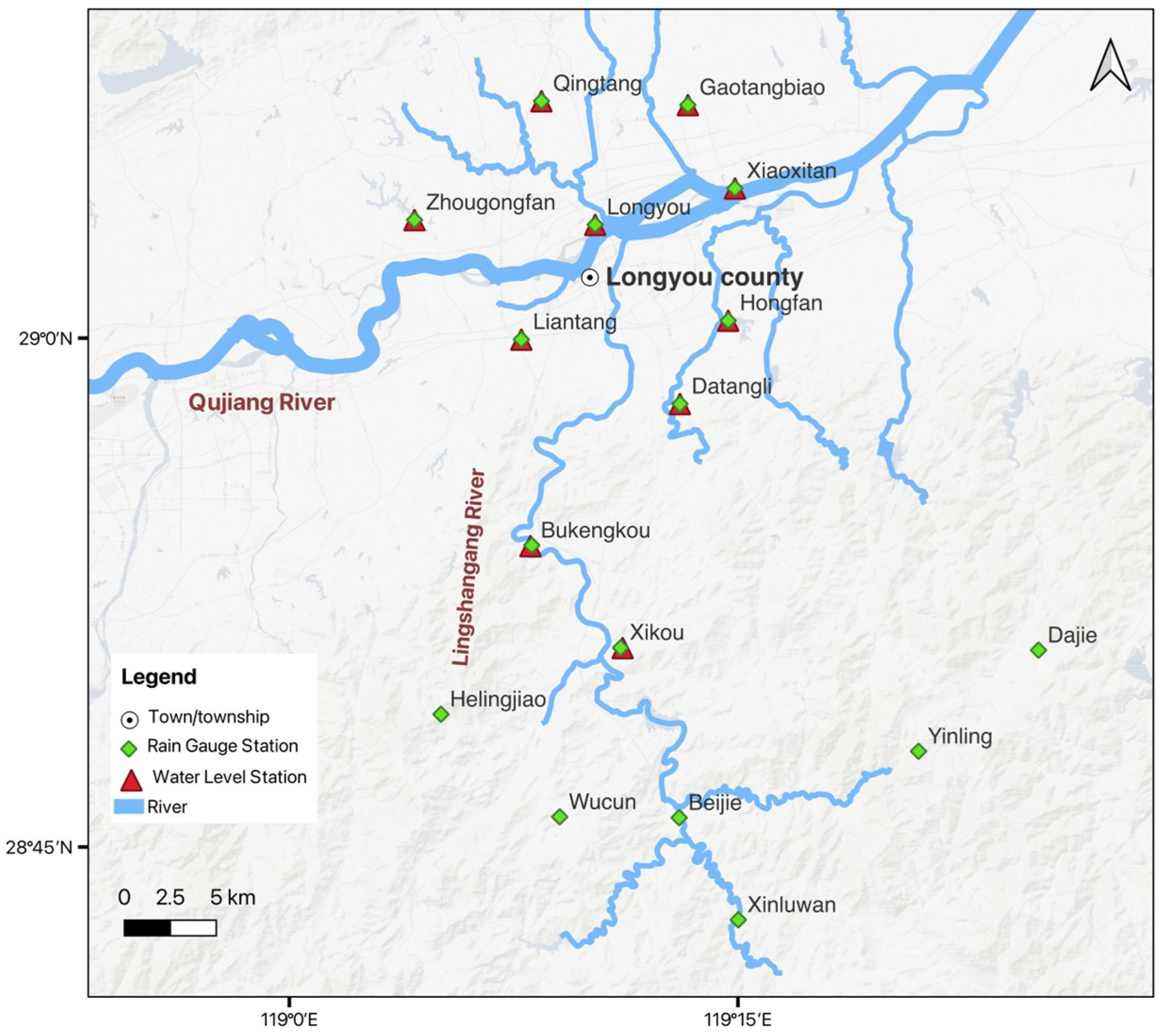
The Qujiang River Basin is characterized by prolonged deep flooding, where the flash flood-prone Lingshangang River intersects with the Qujiang River. This interaction produces compound flood dynamics, which necessitates a coupled 1D–2D modeling approach to capture both rapid upstream inflows and downstream floodplain inundation. To address this complexity, this study applies a coupled 1D–2D hydrodynamic modeling framework to simulate designed flood scenarios in the Qujiang River Basin, Zhejiang Province, China. The model is further integrated with socio-economic data to assess flood inundation extent, affected population, and economic losses under both standard and levee breach conditions. By linking hydrodynamic processes with impact assessment, this study provides a comprehensive framework to support flood risk management, evacuation planning, and decision-making in complex river systems.
3. Results
3.1. Flood Simulation
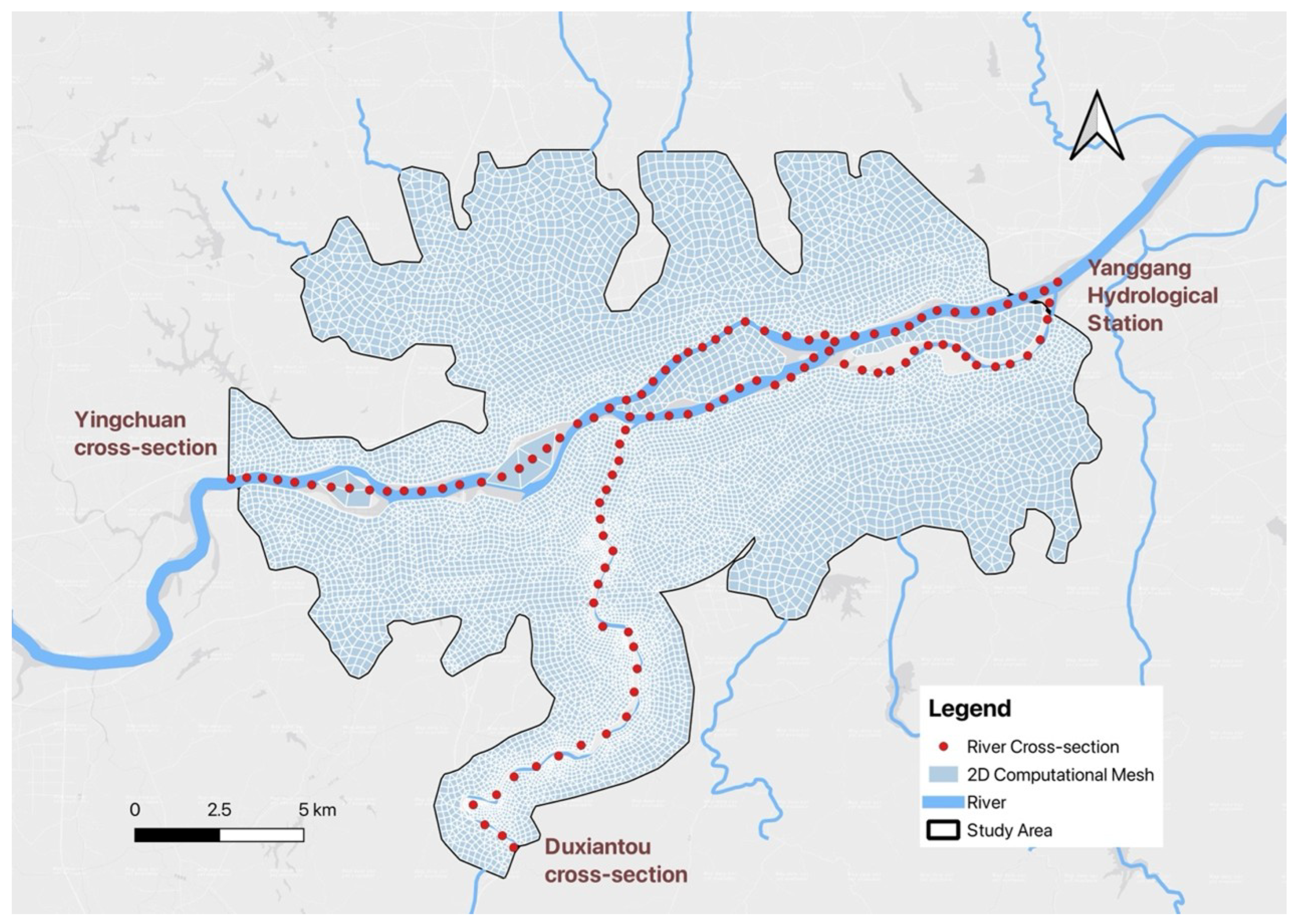
The designed discharge processes at the upstream boundaries of the Qujiang River (Yingchuan cross-section) and the Lingshangang River (Duxiantou cross-section), as well as the corresponding downstream boundary conditions at the Yanggang hydrological station, are presented in
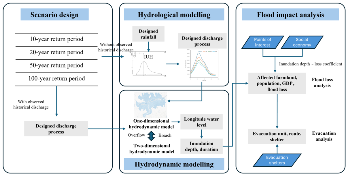
Table 5. These values represent the peak discharges and water levels under different return period scenarios and serve as key inputs for the hydrodynamic simulations. The results were derived based on the scenario design and rainfall-runoff transformation methodology described in
Section 2.3.1.
The hydrodynamic model was calibrated using four historical flood events, namely 20170625, 20200709, 20210702, and 20220620. The selected calibration events represent typical flood conditions in the study area, with peak water levels ranging from 43.02 m to 43.96 m. The flood event of 20150618 was selected as the validation case due to its representativeness of typical flood behavior.
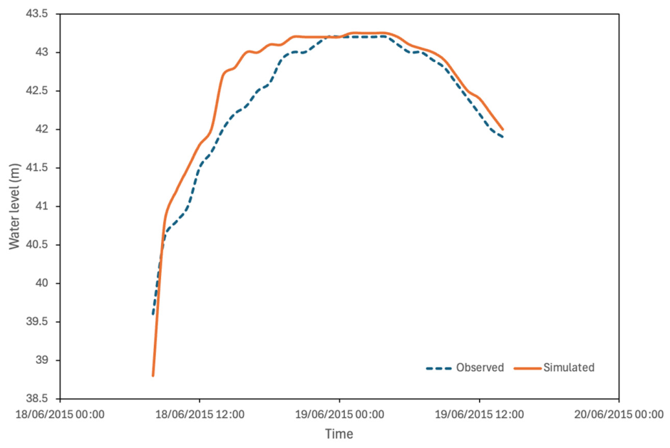
Simulated water levels at the Longyou hydrological station were compared with observed data, as shown in
Table 6. The calibration results show good agreement between simulated and observed peak water levels, with errors ranging from −0.27 m to 0.18 m. For the validation event, the peak water level error is 0.05 m.
Figure 4 presents the comparison between simulated and observed water levels for the validation event at the Longyou hydrological station, showing good agreement in both peak value and overall hydrograph trend. These results indicate that the model can reliably reproduce flood processes under typical hydrological conditions and is suitable for subsequent flood simulation and analysis.
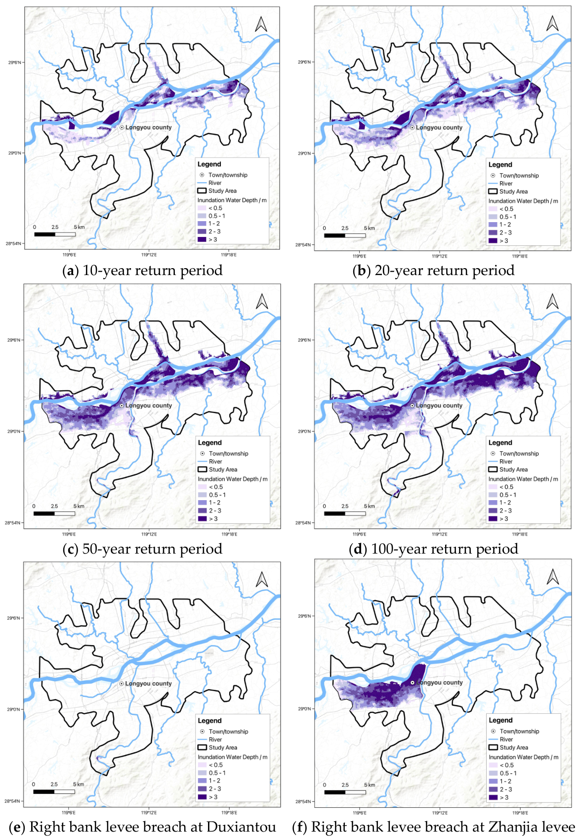
The simulation results of flood design scenarios are presented in
Figure 5.
Figure 5 indicates that flooding originates near the Zhanjia Levee and expands across low-lying areas toward Longyou County, intensifying with increasing return periods, while breaches along the Qujiang River produce significantly more extensive and persistent inundation than that along the Lingshangang River.
For a 10-year return period flood, levee overtopping results in a maximum inundation depth of 8.08 m, a maximum velocity of 1.6 m/s, and a maximum duration of 69 h. The results reveal that overtopping initially occurs near the Zhanjia levee, where water rapidly spreads along low-lying areas, eventually inundating Longyou County. For a 20-year return period flood, the maximum inundation depth increases to 8.36 m, with a velocity of 2 m/s, and a duration of 69 h. For a 50-year return period flood, the maximum depth reaches 9.07 m, with a velocity of 4.3 m/s and an inundation duration of 70 h. In the case of a 100-year return period flood, the maximum inundation depth reaches 10.04 m, with a velocity of 4.6 m/s and a duration of 70 h.
In the scenario of levee breach at Duxiantou along the Lingshangang River, the resulting inundation is relatively limited, covering only 0.17 km2, with a maximum water depth of 4.84 m, a peak velocity of 0.29 m/s, and a peak inundation duration of approximately 5 h. The inundation in Scenario 5 is confined to the right bank of Duxiantou and affects only a limited portion of the Guantang Town. This area is located in a mountainous region with relatively steep terrain, which restricts lateral floodwater spreading. In contrast, a breach at the Zhanjia Levee along the Qujiang River results in a substantially larger inundated area of 29.98 km2, characterized by a maximum inundation depth of 9.44 m, a peak velocity of 1.9 m/s, and an extended duration of up to 56 h, indicating a significantly greater flood hazard in terms of magnitude and persistent inundation. The affected area extends across the right bank of the Qujiang River and inundates the urban center of Longyou County, where population density and economic assets are highly concentrated.
3.2. Flood Impact Results
Flood impact assessment results are summarized in
Table 7. Scenarios 1 to 4 correspond to design floods with return periods of 10, 20, 50, and 100 years, respectively. The results show a progressive increase in impacts, with inundated areas expanding from 35.69 km
2 to 80.78 km
2, affecting populations increasing from 173,000 to 387,000. Inundated farmland also increases steadily from 9.31 km
2 to 18.98 km
2. Correspondingly, estimated flood losses rise significantly from 404.59 million to 1186.34 million CNY, indicating the growing socio-economic vulnerability.
Scenarios 5 and 6 represent levee breach scenarios under a 20-year return period flood. In Scenario 5, the inundated area is limited to only 0.17 km2, which contains comparatively low concentrations of population and economic assets, resulting in a minimal affected population of 400, and the flood losses are 4.38 million CNY. In contrast, Scenario 6 presents a significantly higher flood risk, with an inundated area of 29.98 km2 and total flood losses reaching 426.73 million CNY, highlighting the severe socio-economic consequences of levee breaches in densely developed areas.
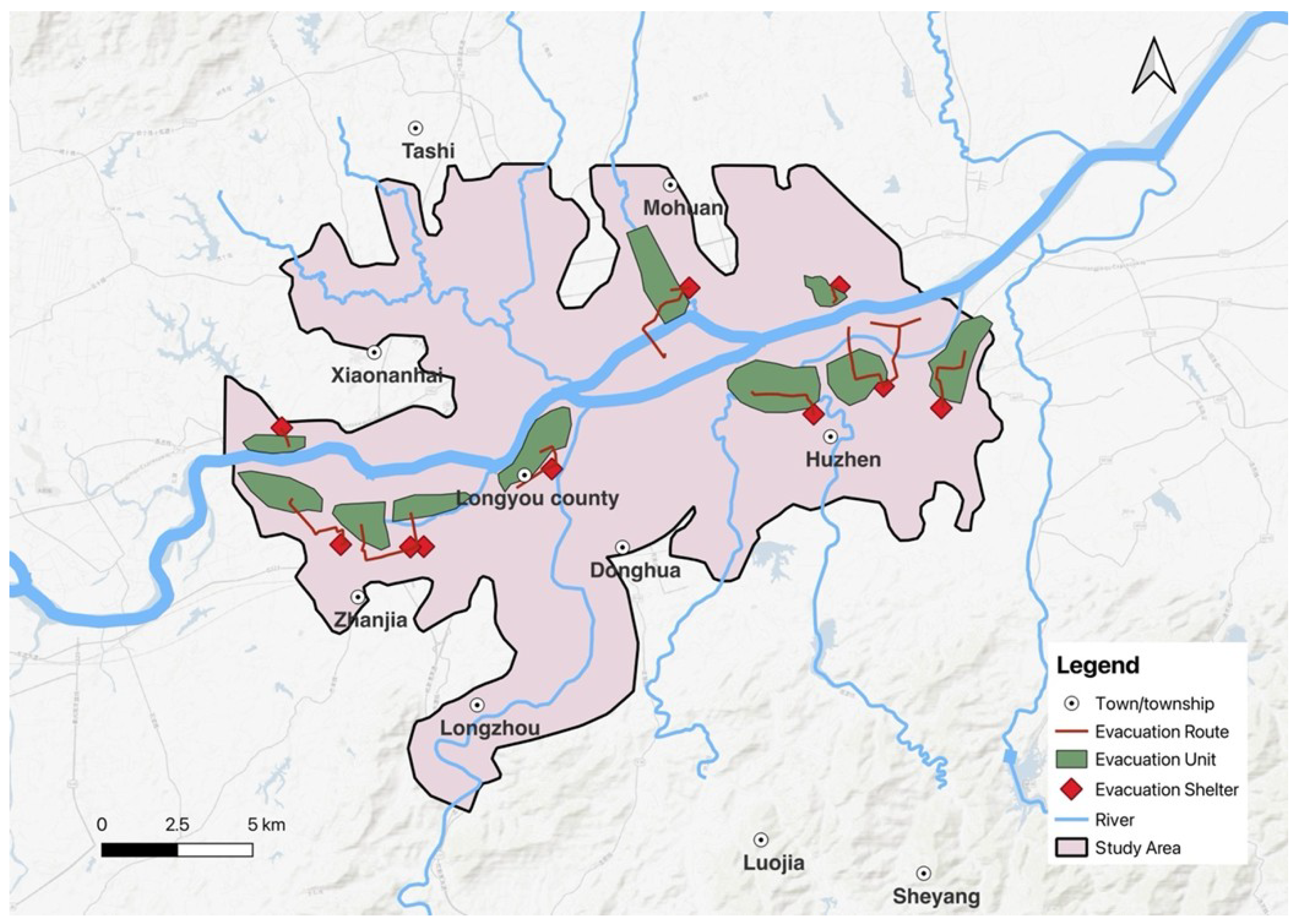
For this study, the 20-year return period event was adopted as the threshold, consistent with regional flood control standards and commonly used in emergency planning as a moderate-to-high risk scenario that balances event probability and potential impact. Ten sites not affected by flooding are selected as evacuation and resettlement areas (shown as red shaded areas in
Figure 6), based on municipal flood control and emergency plans and their elevation and safety from inundation. Evacuation units (shown as green shaded areas in
Figure 6) are defined at the administrative village level, following the principle of nearest resettlement, with a maximum evacuation distance not exceeding 15 km.
Evacuation routes (shown as red lines in
Figure 6) are determined using a shortest-path approach within the road network in QGIS, ensuring that each village is connected to its nearest available safe shelter while avoiding flooded areas. This approach minimizes travel distance while ensuring complete coverage of affected populations.
Figure 6 illustrates that most villages are assigned to nearby safe zones with relatively direct routing.
5. Conclusions
This study presents an integrated flood risk assessment framework combining coupled 1D–2D hydrodynamic modeling with socio-economic impact analysis for the Qujiang River Basin. The results demonstrate that flood extent, depth, and duration increase significantly with return period, while levee breach scenarios introduce substantially higher and more complex risks than design flood conditions alone.
The findings highlight the critical role of the dual-river confluence system, where interactions between the flash flood-prone Lingshangang River and the Qujiang River generate compound flood dynamics that amplify inundation extent and duration. In particular, terrain conditions and breach location strongly influence flood propagation and associated damages.
This research demonstrates the importance of integrated hydrodynamic modeling for flood risk assessment and disaster mitigation planning. The results offer scientific support for the design of the flood defense system, local land use planning and emergency response strategies. Future work should incorporate climate change projections, dynamic land use patterns, and participatory decision-making to support holistic, resilient, and adaptive flood risk management in the Longyou region.