Article

Resilience and Sustainability of Aquifers Under Climatic and Agricultural Pressure

by
Dunia Virto González
1,*,
Lidia Ruiz Pérez
2,
Isabel González-Barragán
1 and
María Jesús González Morales
2
1
Escuela Universitaria de Ingeniería Agrícola (INEA), Universidad Pontificia Comillas, Camino Viejo de Simancas km 4.5, 47008 Valladolid, Spain
2
Departamento de Teoría de la Señal y Comunicaciones e Ingeniería Telemática, Universidad de Valladolid (UVa), Campus Miguel Delibes, Paseo de Belén 15, 47011 Valladolid, Spain
*
Author to whom correspondence should be addressed.
Water 2026, 18(10), 1163; https://doi.org/10.3390/w18101163
Submission received: 16 March 2026 / Revised: 27 April 2026 / Accepted: 2 May 2026 / Published: 12 May 2026
(This article belongs to the Section Hydrogeology)

Abstract

Sustainable groundwater management in regions subjected to intensive agricultural pressure requires reliable simulation tools capable of anticipating the impacts of climate change. However, in overexploited multilayer aquifers such as Tierra del Vino, locally calibrated predictive tools capable of quantifying climate-driven piezometric decline remain scarce. This study develops a numerical groundwater flow model using MODFLOW for the Tierra del Vino aquifer (Spain), a multilayer detrital system currently characterized by a critical quantitative status. Agricultural irrigation accounts for approximately 94% of total groundwater withdrawals, making it the dominant anthropogenic pressure on the system. The model was manually calibrated through more than 500 iterations, achieving a consistent representation of groundwater dynamics. Statistical evaluation based on groundwater level data from 34 piezometric monitoring points distributed across the aquifer yielded a good fit (NSE = 0.816; R = 0.928), supporting the suitability of the model for scenario analysis. Under the RCP 8.5 climate scenario, aquifer recharge could decrease by 31.75%, resulting in a significant piezometric decline within the system. At the representative well selected for the farm-scale agricultural impact analysis, this decline reaches 3.33 m and is used to evaluate its effect on pumping energy costs. The implementation of management measures proposed by the water authority reduces this decline to 1.84 m, although overexploitation conditions persist. These results indicate that current administrative restrictions are insufficient on their own and that future management should adjust abstraction rights to projected recharge conditions, maintaining the exploitation index below 0.8 to reduce the risk of long-term overexploitation. In this context, aquifer resilience is interpreted as the capacity of the groundwater system to respond to the combined pressures of climate change and agricultural abstraction while maintaining its hydrological functioning.

1. Introduction

Climatic droughts constitute complex processes that generate intense impacts and present high uncertainty regarding their future evolution under global warming, posing significant challenges for contemporary societies [1]. Intensive groundwater exploitation has become a global challenge for water security, understood not only as the availability of the resource but also as the capacity to ensure water of adequate quality for human health, livelihoods, and ecosystems under climatic risks [2].
In recent decades, the increase in demand for agricultural irrigation, together with climate variability, has led to persistent declines in groundwater levels in aquifers located in semi-arid regions worldwide. This phenomenon has been widely documented in large-scale systems such as the Central Valley of California, where prolonged overexploitation has resulted in critical rates of storage depletion and land subsidence [3,4].
Similarly, in the North China Plain, where groundwater supplies about 70% of irrigation water, intensive pumping has caused continuous piezometric declines and severe environmental consequences [5]. In this global context of water stress, numerical groundwater flow modelling has emerged as an essential methodology for understanding groundwater system dynamics and evaluating the effectiveness of local management policies.
The Tierra del Vino aquifer, corresponding to groundwater body 400048 in the Duero Basin (Spain), represents a clear case of hydrological imbalance. According to the management criteria used in Spanish hydrological planning, exploitation index values greater than 0.8 are associated with significant pressures due to withdrawals and with situations of quantitative overexploitation. This index is calculated as the ratio between annual groundwater withdrawals and the estimated renewable groundwater resources of the groundwater body, and it is used in Spanish hydrological planning as an indicator of anthropogenic pressure. In this context, the system presents an exploitation index of 1.39, obtained from official data available through the Duero River Basin Authority (CHD), indicating a clearly deficient quantitative status [6]. This issue is not isolated, as at the national scale 38.65% of groundwater bodies are classified as “at risk” of failing to achieve environmental objectives [7]. This pressure is largely driven by irrigated agriculture, which accounts for more than 94% of total withdrawals and compromises the resilience of the system against long-term disturbances [8].
In this study, aquifer resilience is interpreted operationally as the capacity of the groundwater system to respond to the combined pressures of climate change and intensive agricultural abstraction while maintaining its hydrodynamic functioning and storage capacity. Agricultural activity therefore constitutes the dominant anthropogenic pressure on the system and the key element for evaluating its behavior under future scenarios of recharge reduction. As highlighted in the Sixth Assessment Report of the IPCC (AR6), aquifers act as critical buffers against climate variability; however, their resilience is severely reduced when extraction exceeds natural recharge rates, an adaptation limit already observed in many Mediterranean regions [2]. The hydrogeological setting of this system, composed of Tertiary detrital sediments forming a multilayer aquifer system, limits the applicability of simplified approaches and requires a discretization capable of supporting proactive groundwater management [8].
Despite the socioeconomic importance of irrigation in the study area, particularly for high-demand crops such as sugar beet and maize, there is currently a lack of locally calibrated predictive tools capable of quantifying piezometric decline under future climate scenarios such as RCP 8.5. The Fifth Assessment Report of the IPCC (AR5) confirms that Mediterranean regions, including the Iberian Peninsula, will experience a significant reduction in runoff and natural recharge due to decreasing precipitation and increasing evapotranspiration [9]. These projections, reinforced by the recent report by [2], anticipate an intensification of hydrological droughts and increased competition for water resources. This decline in groundwater availability also results in lower piezometric levels, increasing the energy dependence of the agricultural sector by raising the energy required for extraction and, consequently, the operational costs of irrigation, as documented by [10,11].
The objective of this study is to quantify the long-term piezometric response of the Tierra del Vino aquifer under climate change and groundwater abstraction scenarios, and to evaluate its implications for groundwater sustainability and irrigation energy demand. To this end, a calibrated numerical groundwater flow model based on MODFLOW 6 is developed and applied to simulate current conditions, future climate forcing under the RCP 8.5 scenario [12], and the effect of abstraction restrictions proposed by the Duero River Basin Authority.
The novelty of this study lies in three main aspects. First, it applies an extensive manual calibration process (over 500 iterations) to a highly heterogeneous multilayer aquifer system, ensuring physical consistency in a context where automated approaches are often insufficient [13]. This calibration was based on groundwater level observations from 34 piezometric monitoring points distributed across the aquifer, allowing the reproduction of regional groundwater dynamics. Second, it establishes a direct link between piezometric decline and the energy requirements of groundwater pumping, explicitly integrating the water–energy nexus into the analysis through a representative agricultural well used to assess the impact of groundwater level decline on pumping energy costs. Third, the model is supported by real data from agricultural irrigation audits, allowing the connection between regional hydrogeological dynamics and farm-scale operational conditions.
Finally, the aquifer response is evaluated under the RCP 8.5 scenario. This high-emission scenario, which projects a radiative forcing of 8.5 W/m2 by the year 2100 [12], is used as a “worst-case” reference framework to test the resilience of the system under severe reductions in net recharge. Although this study focuses on the RCP 8.5 scenario, previous research in Spain has already estimated recharge reductions of up to 58% under comparable high-emission projections [14]. The integration of this scenario with the groundwater withdrawal restriction measures proposed by the CHD provides a quantitative scientific basis for assessing aquifer response under severe climate forcing and for supporting adaptive groundwater management in overexploited multilayer systems.

2. Study Area

2.1. Geographical Setting and Hydrogeological Framework

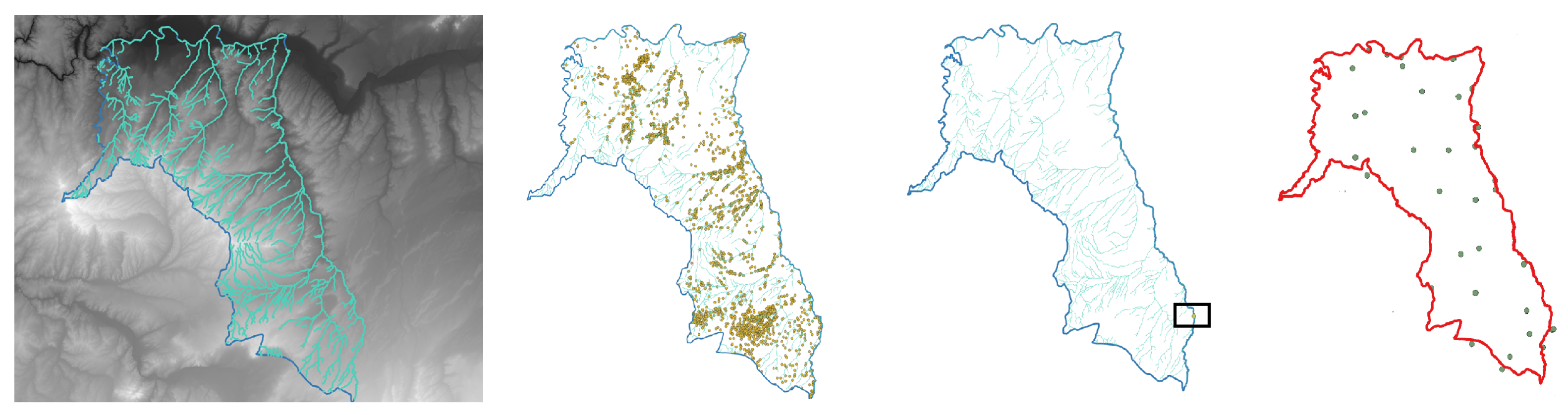
This study focuses on the Tierra del Vino aquifer, administratively defined as Groundwater Body (MASub) 400048 within the Duero River Basin Hydrological Plan, whose nomenclature follows the official coding established under the Water Framework Directive (WFD) and the Hydrological Plan of the Spanish part of the Duero River Basin District [15]. This strategic hydrogeological unit, located in the central-western sector of the Duero Basin, covers an area of 1785.44 km2 and administratively extends across the provinces of Salamanca, Zamora, and Valladolid. The regional location of the Tierra del Vino aquifer within Spain and the Duero River Basin is shown in Figure 1. A more detailed representation of the study area, including the digital elevation model, the hydrographic network, the spatial distribution of groundwater abstraction wells, the location of the agricultural pumping well analysed in this study, and the piezometric monitoring network used for groundwater model calibration, is presented in Figure 2.
The topography of the area is characterized by a gentle regional slope, with an altimetric gradient ranging from 957 m in preferential recharge zones to 627 m in local base levels.
From a hydrogeological perspective, the Tierra del Vino groundwater body is mainly composed of Tertiary detrital materials and Quaternary superficial deposits. According to the Geological and Mining Institute of Spain (Instituto Geológico y Minero de España, IGME), the Tertiary sequence is predominantly Paleogene in age, while Miocene formations occur locally in the southern and southeastern sectors of the groundwater body. These materials consist of a heterogeneous succession of conglomerates, sandstones, lutites, marls, and locally carbonate levels, arranged discordantly and locally affected by tectonic structures trending NE–SW. Quaternary deposits are scarce and discontinuous, corresponding mainly to Holocene alluvial plains and Pleistocene terraces associated with the fluvial network [16].
According to official hydrogeological information from the Duero River Basin Authority (Confederación Hidrográfica del Duero, CHD), compiled through the MÍRAME-Duero viewer, this geological architecture gives rise to a multilayer detrital aquifer system. The uppermost level corresponds to a Quaternary alluvial aquifer, characterized by unconfined hydraulic conditions and intergranular porosity, associated with Pleistocene–Quaternary alluvial terraces. Beneath this level, several layers belonging to the Tertiary detrital sequence are developed, defined as non-alluvial detrital materials with tabular geometry and intergranular porosity, with lithologies dominated by arkoses, siliceous conglomerates and, locally, silts and clays [15].
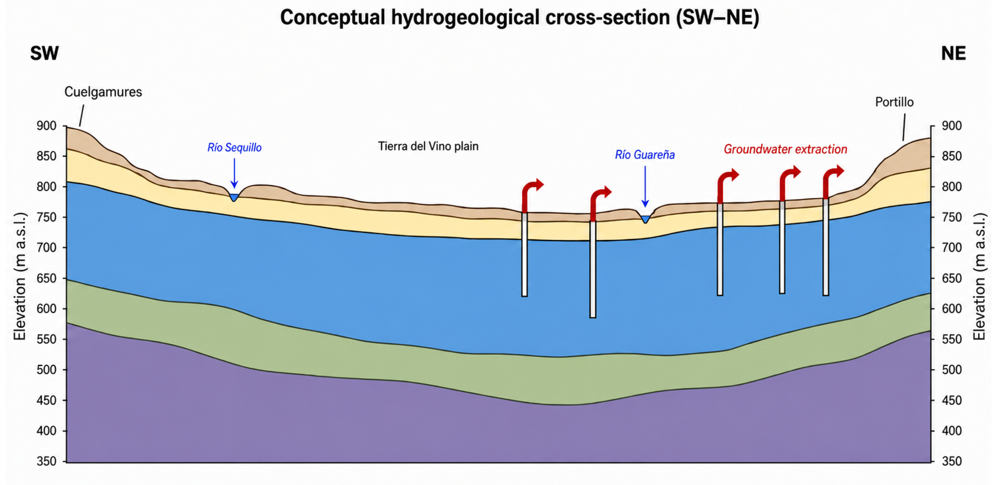
CHD hydrogeological interpretations indicate that the upper layers of the Tertiary detrital sequence exhibit predominantly unconfined hydraulic conditions, whereas deeper levels display mainly confined behaviour. Although the system comprises several differentiated hydrostratigraphic levels, these units do not behave as completely isolated aquifers. Clay intercalations and lutite layers may locally generate confined or semi-confined conditions; however, the system functions as a hydraulically connected multilayer aquifer. This configuration allows vertical groundwater exchange between detrital levels, particularly where permeable materials such as sands and conglomerates show lateral continuity. The thicknesses of these units are highly variable, ranging from a few metres to more than 400 m in deeper levels, and transmissivity values span several orders of magnitude. This variability in thickness, lithology, and hydraulic conditions reveals marked vertical and lateral heterogeneity within the system, consistent with the stratigraphic complexity described by IGME [15,16]. Accordingly, the numerical model represents the aquifer using seven differentiated layers based on lithostratigraphic and hydrodynamic criteria [13].
To illustrate the hydrogeological architecture of the Tierra del Vino aquifer system, Figure 3 presents a conceptual hydrogeological cross-section based on the regional interpretation developed by the Duero River Basin Authority (Confederación Hidrográfica del Duero, CHD). This scheme represents the vertical arrangement of the main stratigraphic units and the multilayer configuration of the aquifer system, highlighting the relationship between the superficial Quaternary deposits and the underlying Tertiary detrital formations that constitute the main hydrogeological reservoir of the groundwater body [17].

2.2. Agricultural Use Context and Extraction Pressure

The exploitation of groundwater resources in MASub 400048 is intrinsically linked to a marked agricultural specialization. Irrigation constitutes the dominant anthropogenic use, representing more than 94% of the total extraction volume recorded in the database of private water use rights. According to the official inventory of pressures compiled by the Duero River Basin Authority and consulted through the cartographic information system [18], the distribution of water demand for groundwater body 400048 is classified as follows:
  • Agricultural use (irrigation): 5447 authorized abstractions representing an annual volume of 86.37 hm3/year [18].
  • Public water supply: 101 abstractions for human consumption, accounting for 3.50 hm3/year [18].
  • Industrial and minor uses: 869 abstractions with a marginal volume of 0.51 hm3/year [18].
Groundwater body MASub 400048–Tierra del Vino presents a complex management scenario due to its marked hydrological imbalance, reflected in an exploitation index of 1.39 [15]. The spatial scope of the study encompasses the entire Tierra del Vino groundwater body; however, the detailed analysis of climate change impacts on groundwater resources focuses on the agricultural sector of Peñaranda de Bracamonte, which represents one of the most representative and sensitive zones within the aquifer. In this sector, current hydrological planning [19] establishes for high water-demand crops such as maize a net irrigation allocation of 4878 m3/ha/year, which acts as a concession limit and is applied exclusively to modernized irrigation areas.

2.3. Justification and Selection of the Detailed Calibration Area

The numerical model has been developed for the entire groundwater body 400048; however, manual calibration and validation have been concentrated in the area between Poveda de las Cintas, Palaciosrubios, and Zorita de la Frontera. The detailed analysis focuses on the municipality of Palaciosrubios, within the agricultural district of Peñaranda de Bracamonte (Salamanca). The analysed sector, which includes the municipalities of Poveda de las Cintas, Zorita de la Frontera, and Palaciosrubios, represents approximately 3% of the total surface area of groundwater body 400048 (Tierra del Vino). This selection was not based on specific hydrogeological singularities, but rather on the availability of reliable information on actual groundwater use and its direct link with agricultural activity.
Within this area, a representative agricultural farm with instrumented monitoring provides real data on irrigated surface, irrigation systems, applied water volumes, and operational parameters of the pumping equipment. The analysed well has a total depth of 115 m and abstracts groundwater from the lower, or general, aquifer horizon of the Tierra del Vino groundwater body. It operates under an administrative concession of 30,000 m3/year, which defines the maximum authorized annual extraction volume. In the absence of continuous pumping records, this concession value was considered a representative approximation of annual groundwater abstraction. The availability of these records regarding flow rates, abstraction depth, and energy consumption supports the integrated assessment of groundwater extraction and irrigation energy requirements.
From an agronomic perspective, high water-demand crops such as sugar beet and maize predominate in the area, and their economic viability largely depends on the energy cost of groundwater pumping. The recent increase in energy prices has intensified this vulnerability, promoting initiatives aimed at improving energy efficiency and water use in agricultural holdings. Consequently, the selected area constitutes a representative case of groundwater-dependent irrigated agriculture, where energy pressure and uncertainty regarding future water availability converge.
The availability of this information makes it possible to directly link the piezometric evolution simulated by the regional model with actual agricultural operating conditions, establishing an explicit connection between aquifer dynamics and the technical and energetic viability of irrigation. This multiscale approach—regional for hydrogeological simulation and local for farm characterization—strengthens the applied representativeness of the study and facilitates the interpretation of climate change impacts on groundwater-dependent agricultural systems.

3. Methodology

Groundwater flow simulation was carried out using the MODFLOW 6 computational engine, the most recent version of the MODFLOW family of models developed by the U.S. Geological Survey [20,21]. This version allows a finite-volume formulation that ensures a more robust mass balance in systems with complex geometries. The graphical interface ModelMuse Version 4 was used for grid design, assignment of hydraulic properties and post-processing of results [22]. The combination of both tools allows for the efficient integration of the different flow packages and boundary conditions required to represent the aquifer system.

3.1. Data Used and Information Sources

The numerical model was constructed by integrating information from several official hydrogeological and climatic data sources. Groundwater levels used for model calibration and validation were obtained from the official piezometric monitoring network managed by the Geological and Mining Institute of Spain (Instituto Geológico y Minero de España, IGME), which provides periodic records of groundwater levels from observation points distributed within the Tierra del Vino groundwater body [23].
The regional hydrogeological characterization of the system, the definition of aquifer geometry, and the identification of the main components of the groundwater balance were based on information provided by the Duero River Basin Authority (Confederación Hidrográfica del Duero, CHD) through its official hydrological planning documents and the MÍRAME-Duero hydrogeological viewer. This platform integrates official hydrogeological cartography, borehole logs, stratigraphic layer schemes, and the spatial delimitation of groundwater bodies, including groundwater body 400048 (Tierra del Vino) [6].
Climate projections used in the analysis are based on the scenarios from the Fifth Assessment Report of the Intergovernmental Panel on Climate Change (IPCC AR5). These projections were regionalized for Spain by the Spanish State Meteorological Agency (AEMET) using an analog method and later applied by the Centre for Hydrographic Studies of CEDEX to assess the impact of climate change on water resources. Projected changes in groundwater recharge were obtained from the regionalized results available through the CAMREC application, which is used as an official reference for the analysis of future scenarios [24,25].
Crop water requirements under baseline and future climatic conditions were estimated using FAO CROPWAT 8.0 for Windows [26], a software tool developed for crop water requirement estimation and irrigation scheduling.
In addition to the official hydrogeological and climatic sources, detailed information at the farm scale was incorporated from an energy and water audit carried out on an irrigated farm located near Palaciosrubios (Salamanca), within the area influenced by the well used as the local analysis point of the model. This audit provided real data on irrigated surface area, irrigation systems, applied water volumes, energy consumption, pumping characteristics, dynamic water levels in the well, and operational parameters of the pumping equipment during the 2021 irrigation campaign.
The information obtained made it possible to characterize in greater detail the hydraulic and energy functioning of the farm, serving as a basis to: (i) define representative pumping conditions in the vicinity of the study well, (ii) estimate energy consumption associated with different crops and irrigation systems, and (iii) analyse the sensitivity of the local production system to piezometric declines and variations in water requirements under climate change scenarios. These data were used as a local-scale reference and complemented the regional modelling without conditioning the overall hydrogeological parameterization of the model.
The methodological workflow followed in this study comprised: (i) compilation and integration of hydrogeological, piezometric and climatic data, (ii) definition of the conceptual model of the multilayer aquifer system, (iii) construction of the numerical groundwater flow model using MODFLOW 6, (iv) iterative manual calibration based on observed piezometric levels, and (v) simulation of climate change and management scenarios to evaluate the response of the aquifer system.

3.2. Grid Design and Spatial Discretization

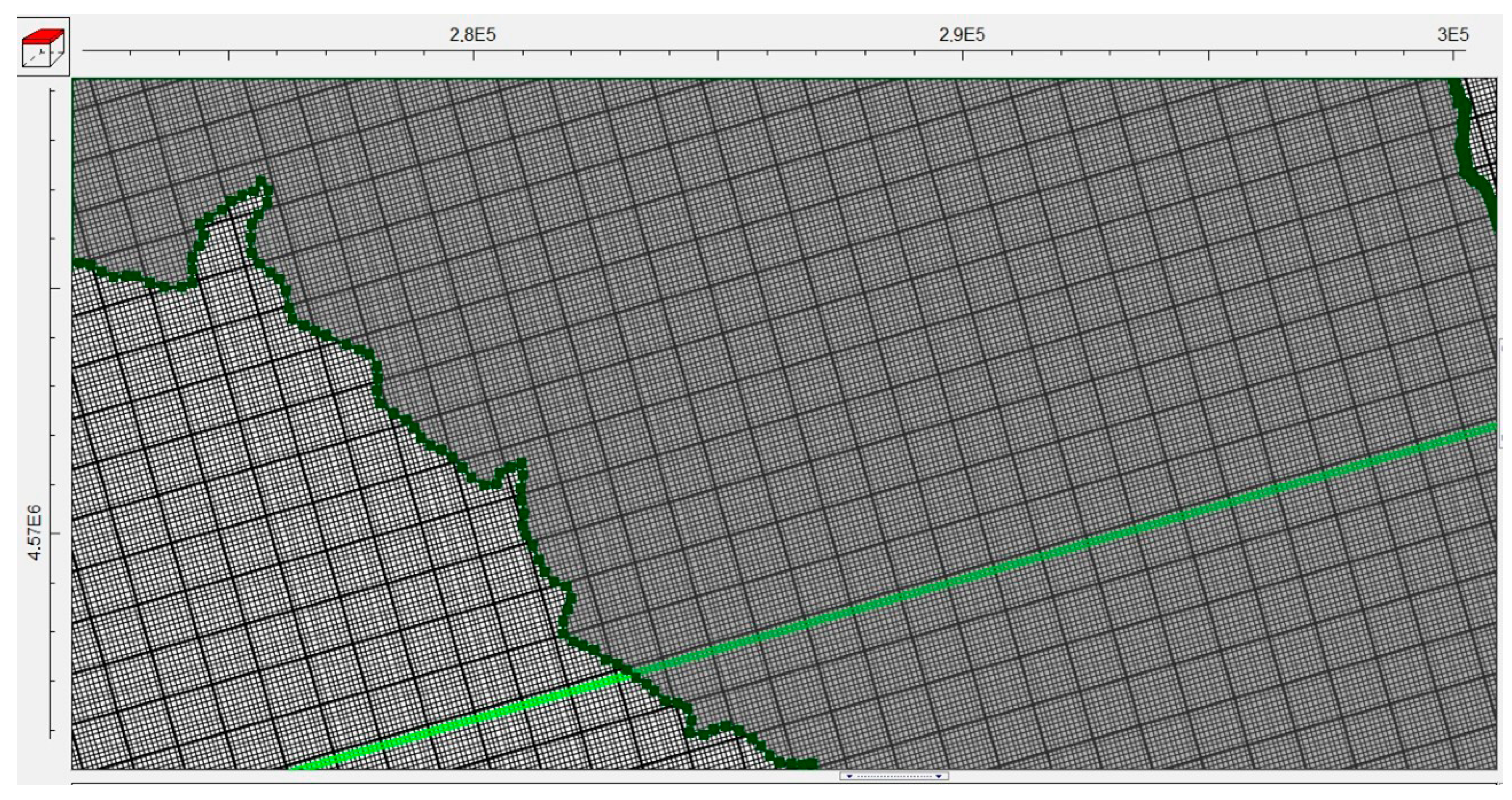
The model domain was configured to cover the entire extent of the groundwater body MASub 400048–Tierra del Vino. The model architecture is based on a structured finite-difference grid with uniform cells of 100 × 100 m. Each cell represents an area of 10,000 m2, equivalent to 1 hectare (0.01 km2).
Considering that the total surface area of the Tierra del Vino aquifer is 1785.44 km2, the spatial discretization results in approximately 178,544 active cells per layer. Since the multilayer system was represented using seven vertical layers, the complete model consists of approximately 1,249,808 three-dimensional cells. This spatial resolution is justified according to two complementary criteria:
  • Physical representativeness: The adopted spatial resolution (100 × 100 m; 1 ha per cell) is appropriate for the regional scale of the Tierra del Vino aquifer (1785.44 km2), as it allows a sufficiently detailed representation of the spatial distribution of abstractions and the associated hydraulic gradients, particularly in areas of intensive irrigation. This discretization is also consistent with the density and spatial distribution of the piezometric monitoring points used during calibration, facilitating a coherent comparison between simulated and observed groundwater levels.
  • Numerical efficiency: The grid dimension ensures robust convergence and accurate mass balance in MODFLOW 6 [21], enabling the efficient execution of the more than 500 iterations required during the manual calibration process. This methodological approach is consistent with previous studies on climate-driven groundwater simulations, such as [27], which highlight the capability of MODFLOW to integrate variable recharge data as a key factor for predicting piezometric surface behaviour under climate change scenarios. The resulting spatial discretization and grid layout are shown in Figure 4.

3.3. Vertical Structure and Hydraulic Parameterization

The definition of the model geometry was carried out by integrating the technical information available in the official MÍRAME-Duero viewer of the Duero River Basin Authority (Confederación Hidrográfica del Duero, CHD), complemented with lithological logs from boreholes belonging to the official monitoring network. This information made it possible to discretize the aquifer system into seven vertical layers, representing the multilayer behaviour of the detrital aquifer of the Tierra del Vino Groundwater Body according to the official hydrogeological framework [6,28].
The upper layer corresponds to Quaternary alluvial materials associated with floodplains and fluvial terraces. This unit has a relatively small thickness and a discontinuous spatial distribution conditioned by the current geomorphology. From a hydraulic perspective, this layer presents predominantly unconfined conditions and hydraulic conductivity values consistent with its detrital lithology, acting as the superficial unit of the system where these materials are present.
The underlying layers represent the Tertiary detrital materials that constitute the main body of the aquifer. These layers group units dominated by conglomerates and sands, with intercalations of silts and lutites of lower permeability. According to official hydrogeological information, the upper Tertiary levels present predominantly unconfined behaviour, whereas the deeper levels show mainly semi-confined conditions associated with a progressive increase in confinement with depth [6].
In accordance with this hydrostratigraphic configuration, the initial hydraulic parameterization of the model was based on the hydraulic conductivity ranges documented by CHD for groundwater body 400048, ranging between 1 × 10 3 and 1 × 10 6 m/s depending on lithology, degree of compaction, and depth of the materials. These values were used as initial reference conditions and were subsequently adjusted during the calibration process to improve the agreement between simulated and observed piezometric levels.
The hydraulic characterization of the model was based on assigning differentiated horizontal and vertical hydraulic conductivity values to each layer. All layers were defined as convertible so that the hydraulic regime (unconfined or semi-confined) could be dynamically determined according to the position of the hydraulic head relative to the top of each layer. In this context, transmissivity is not introduced as an independent parameter but is internally calculated by the model from the horizontal hydraulic conductivity and the effective saturated thickness of each cell. This approach allows the representation of the spatial variability of the hydraulic behaviour of the system and the vertical transfer of flow between layers.
Hydraulic isotropy was assumed in the horizontal plane ( K x = K y ), since no specific hydrogeological evidence indicating preferential directional anisotropy in plan view was available for the analysed groundwater body. In the vertical direction, a constant anisotropy was adopted, defining the vertical hydraulic conductivity as K z = K x / 9.5 , in accordance with the parameterization used in the final model [6]. This assumption is consistent with the stratified nature of the Tertiary detrital deposits (alternation of detrital levels and finer low-permeability materials) and with the presence of semi-confining clay lenses described for this groundwater body, which increase resistance to vertical flow relative to horizontal flow [6,28]. The inclusion of this anisotropy is essential for reproducing the relative degree of confinement between layers and the vertical transfer of flow within the multilayer system, thereby affecting the simulated piezometric differentiation of the aquifer.

3.4. Boundary Conditions and System Inputs

Boundary conditions, sources, and sinks of the model were defined using the official hydrological information provided by the Duero River Basin Authority (Confederación Hidrográfica del Duero, CHD) through the MÍRAME Duero viewer [6], adapting it to a distributed representation using MODFLOW 6 [21].
Diffuse natural recharge was incorporated using the RCH package, applied to the upper layer of the model, which represents the Quaternary materials. This recharge corresponds to the effective infiltration of precipitation estimated by CHD for the groundwater body, amounting to 37.82 hm3/year. To this component, the fraction of infiltrated irrigation return flows was added, estimated at 16.66 hm3/year, which represents an indirect anthropogenic recharge associated with agricultural activity [6].
Groundwater abstractions were represented using the WEL package, assigning negative flow rates to the cells corresponding to the wells inventoried within the study area. The total extracted volume is consistent with the official CHD estimates, which place the actual extraction at 84.32 hm3/year compared to an authorized volume of 91.92 hm3/year for the entire groundwater body [6]. These abstractions constitute the main anthropogenic sink of the system and the dominant factor affecting the simulated piezometric regime.
Groundwater evapotranspiration, dependent on water table depth, was represented using the EVT package, applied at the upper surface of the model. This term acts as a natural sink whose intensity depends on the depth of the piezometric level, allowing the simulation of groundwater losses toward the unsaturated zone and phreatophytic vegetation in sectors where the water table is shallow [21].
The interaction between groundwater and surface watercourses was incorporated using the DRN package, which simulates discharge when the piezometric level exceeds the drainage elevation defined in the cells associated with the main hydrographic network. This mechanism represents the natural discharge of the aquifer toward river channels and preferential drainage areas [29].
No external water balance equations were formulated outside the model. Instead, the balance between inflows and outflows is computed internally through the solution of the groundwater flow equation and subsequently aggregated for comparison with the global recharge and abstraction values reported by CHD.

3.5. Calibration Strategy and Numerical Adjustment

Model calibration was performed under steady-state conditions with the objective of adjusting the mean piezometric levels of the system to the observed hydrogeological conditions. This approach provided a consistent hydraulic reference state prior to evaluating the behaviour of the aquifer under different analysis scenarios.
The selection of steady-state conditions responds to the objective of the study, which focuses on evaluating long-term structural modifications in the mean hydraulic state of the system derived from sustained variations in recharge and groundwater abstractions. The aim is not to reproduce intra-annual dynamics or short-term transient events, but rather to characterize the representative hydraulic equilibrium of the aquifer under multi-year average conditions.
In large regional multilayer detrital systems with high storage capacity, such as the Tierra del Vino aquifer, hydraulic response times are relatively long, which justifies the use of a steady-state approach to represent the integrated state of the system. This approach makes it possible to establish a robust baseline condition on which sustained climate-driven perturbations can be evaluated.
Consistent with this approach, future scenarios were implemented as sustained perturbations of mean recharge and groundwater abstraction, and the system response was evaluated in terms of changes in the long-term hydraulic equilibrium rather than short-term transient fluctuations.
No formal sensitivity analysis was performed in this study; therefore, the individual influence of hydraulic parameters on model response was not explicitly quantified. This limitation should be considered when interpreting the results, particularly under long-term climate scenarios.
  • Methodological approach. Given the hydrogeological complexity of the Tertiary detrital aquifer and the marked spatial heterogeneity of its hydraulic properties, an iterative manual calibration procedure based on the trial-and-error technique was adopted. This approach was considered appropriate for a regional multilayer model, where hydrogeological interpretation and progressive parameter control are fundamental [13].
  • Iterative process. The adjustment required a large number of successive model runs (more than 500), allowing the progressive refinement of the spatial zonation of hydraulic conductivities, particularly in sectors subjected to greater anthropogenic pressure from groundwater abstraction.
  • Control data. Calibration was carried out by comparing simulated piezometric levels with observed levels obtained from the official piezometric monitoring network managed by the Geological and Mining Institute of Spain (IGME), previously described in the data sources section.
  • Calibration criteria. Following the recommendations for the construction and evaluation of groundwater flow models described by [13], calibration was oriented to simultaneously ensuring:
    consistency between simulated piezometric levels and observed values through the adjustment of effective hydraulic conductivities;
    numerical stability of the finite-difference solution scheme;
    a mass balance with a reduced percentage error, ensuring the internal consistency of the model.
  • Initial parameterization conditions. The initial values of the hydraulic parameters used as the starting point of the calibration process were established from the official technical information of the Duero River Basin Authority, previously described in the hydraulic parameterization section. The final adjusted values, together with the model performance statistics, are presented in the Results section.

4. Results and Discussion

4.1. Model Validation

Calibration was performed under steady-state conditions to adjust the mean piezometric levels of the system. Given the complexity of the Tertiary detrital aquifer system, an exhaustive manual calibration process involving more than 500 successive model runs was carried out. This trial-and-error approach, based on the progressive zonation of parameters, made it possible to refine the model response in the critical sector subjected to the highest anthropogenic pressure. Following the protocols for the construction, calibration and verification of groundwater flow models described by [13], the effort devoted to this manual adjustment ensured consistency with the observed piezometry, numerical stability, and an internally consistent water balance.
It is important to highlight that although the statistical evaluation presented below encompasses the entire groundwater body 400048, the calibration effort was intensified in the specific study sector where groundwater abstraction pressure is highest and where a higher density of information is available to verify the adjustment. This strategy ensures that the subsequent analysis of climate change impacts is conducted in the area where the model exhibits its highest predictive capability and best local fit while maintaining regional flow consistency.
The regional modelling approach adopted is consistent with the objective of the study, which is to evaluate the response of the entire aquifer system to sustained perturbations in recharge and groundwater abstraction, while local refinement improves interpretation in the area of detailed analysis.
Starting from the initial hydraulic conductivity (K) ranges defined from official hydrogeological information and from the hydrostratigraphic interpretation of the system, manual calibration allowed the identification of effective K values that reproduce the observed piezometric trends and represent the heterogeneity of the detrital Tertiary formations within the model domain. The final adjustment can be summarized in the following elements, which constitute the hydraulic basis of the calibrated model:
  • Main aquifer (Layer 5): this level behaved as the most influential in the hydrodynamic response of the system within the model domain. Calibration resulted in an effective hydraulic conductivity on the order of 2.205 × 10 4 m s 1 (≈ 19.05 m d 1 ). This value is consistent with relatively permeable detrital materials (sands/conglomerates with silty fractions) described for productive Tertiary levels in the regional hydrogeological information.
  • Lower-permeability units (Layers 1, 2, 3, 4, 6 and 7): these layers were parameterized with hydraulic conductivities significantly lower than those of the main aquifer, within the documented regional ranges, in order to represent the presence of finer detrital materials, partially cemented levels and/or silty and clayey intercalations that induce semi-confined conditions at depth. In the model, their function is to modulate effective transmissivity by layer and control vertical flow transfer between layers, consistent with the observed piezometric differentiation. The assignment of these values was adjusted during calibration, avoiding the imposition of a single identical value for all layers if such an assumption did not improve the fit or lacked hydrogeological justification.
  • Vertical anisotropy: a constant vertical anisotropy ratio of K x / K z = 9.5 was maintained in the calibrated model.
The suitability of the adjustment is supported by the statistical consistency of the model. At this stage, the correct reproduction of piezometric levels was taken as the main reference, manually adjusting hydraulic properties to robustly replicate the observed dynamics in the area of interest. This methodological approach is consistent with regional modelling strategies incorporating local refinement [30], in which systematic calibration allows the optimization of model response in specific sectors without losing regional coherence.
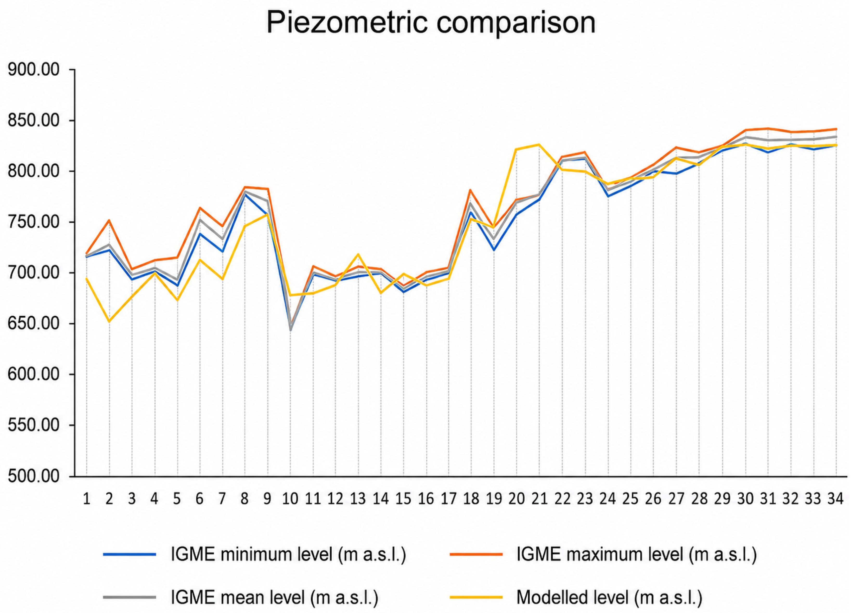
To quantify the reliability of the simulations, cross-validation was carried out by comparing records from 34 official observation points obtained from the CHD MÍRAME Duero viewer [6] against the values simulated by the model. Following the guidelines of [31], who emphasize that robust evaluation should integrate both graphical inspection and quantitative analysis, the following statistical performance measures (PM) were employed:
  • Nash–Sutcliffe Efficiency (NSE): a normalized statistic that compares residual variance to the variance of measured data [32]. It ranges from to 1, where 1 indicates perfect agreement. Result obtained: 0.816. This value indicates a high level of agreement between observed and simulated groundwater levels.
  • Mean Absolute Error (MAE): the mean absolute difference between simulated and observed levels, expressed in physical units (m). Result obtained: 20.49 m, a magnitude considered acceptable for a regional model of this scale.
  • Root Mean Square Error (RMSE): the square root of the mean squared error, sensitive to larger deviations. Result obtained: 27.79 m, reflecting the dispersion associated with aquifer heterogeneity and local variability in areas with higher pumping density.
  • Standard deviation of residuals (SDres): standard deviation of the residuals between simulated and observed mean piezometric levels, used as a complementary measure of calibration error dispersion. Result obtained: 26.98 m.
  • Mean Absolute Percentage Error (MAPE): mean relative error expressed as a percentage. Result obtained: 2.9%, indicating a small relative difference and overall stability of the model fit.
  • Pearson correlation coefficient (R): measures the strength of the linear relationship between observed and simulated values. Result obtained: 0.928, confirming a very strong direct relationship.
  • Coefficient of determination ( R 2 ): represents the fraction of variance explained by the model fit. Result obtained: 0.819, indicating that 81.9% of the variability in measured groundwater levels is explained by the model. The remaining percentage is associated with factors not explicitly represented and with the inherent variability of the data.
An evaluation using graphical performance measures (PM) was also incorporated. According to [31], the use of graphical PM is essential for robust evaluation because it allows direct comparison between measured and simulated values and helps identify systematic biases that statistical indicators alone might not detect. Visual comparison of groundwater levels, shown in Figure 5, confirms that the simulated trend faithfully reproduces the observed piezometric response.

4.2. Future Scenario Analysis

The simulation of future conditions is based on the incorporation of regionalized climate projections together with the management measures planned by the Duero River Basin Authority (CHD) for the Tierra del Vino groundwater body (400048). The climate projections used originate from the CAMREC programme developed by CEDEX, which provides climate regionalizations for Spain based on general circulation models included in the Fifth Assessment Report of the IPCC (AR5). In this study, the RCP 8.5 emissions scenario has been considered, corresponding to a radiative forcing of 8.5 W/m2 by the end of the twenty-first century, with the time horizon 2040–2070 and the control period 1961–2000. Although the climate scenario adopted in this study is based on the AR5 framework, more recent projections from the IPCC AR6, particularly under the SSP5-8.5 scenario, show a comparable evolution in both the magnitude and direction of climate change. Both approaches converge towards similar radiative forcing levels by the end of the 21st century and project consistent trends, including temperature increase, enhanced evapotranspiration, and a reduction in effective recharge, especially in Mediterranean regions [2]. In this context, the results obtained under the selected scenario are consistent with the most recent climate projections.
The projections are based on a multimodel ensemble of general circulation models. To represent the future climate signal, the multimodel mean of six GCMs was used, a practice widely adopted in climate impact studies to characterize the common forced response and reduce the influence of individual model biases. This approach is consistent with the way IPCC assessments analyse climate projections using multimodel ensembles, considering the combined response as a more robust estimate than that derived from a single model.
Under this climate scenario, the main hydrological modifications introduced into the hydrogeological model were a mean reduction in actual evapotranspiration of 5.465 % and a mean decrease in aquifer recharge of 31.75 % , values obtained from the regionalized outputs of the multimodel ensemble for the RCP 8.5 scenario during the period 2040–2070. These modifications were implemented directly in the recharge and evapotranspiration terms of the hydrogeological model, as both parameters integrate the combined effects of projected variations in precipitation and temperature on the basin water balance.
In addition to climate forcing, the future scenario incorporates the management measures planned by CHD, which include a reduction of total groundwater abstractions of approximately 16.5 hm3/year for the groundwater body, with the aim of bringing the exploitation index closer to unity and improving the balance between resources and demands. This reduction was implemented in the model by adjusting pumping rates in the MODFLOW WELL package.
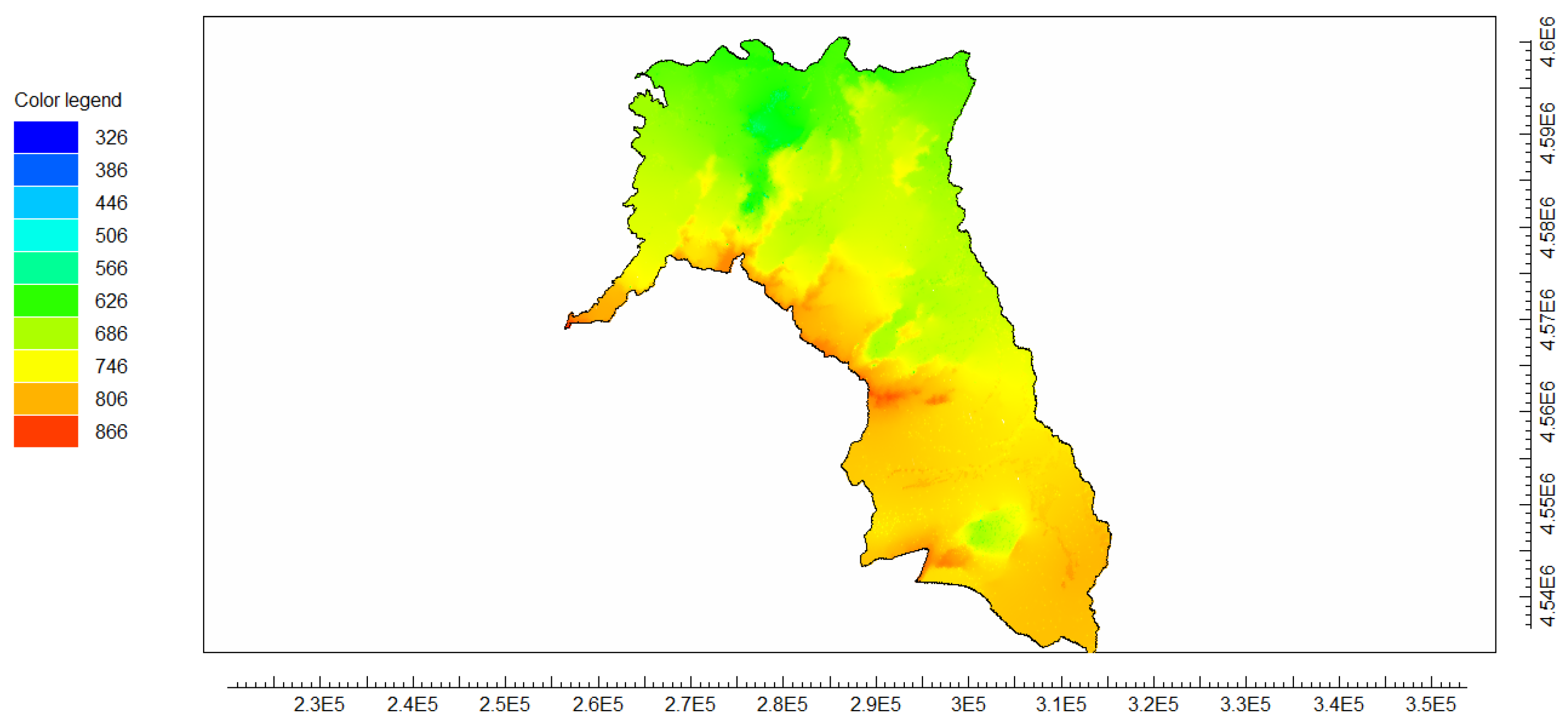
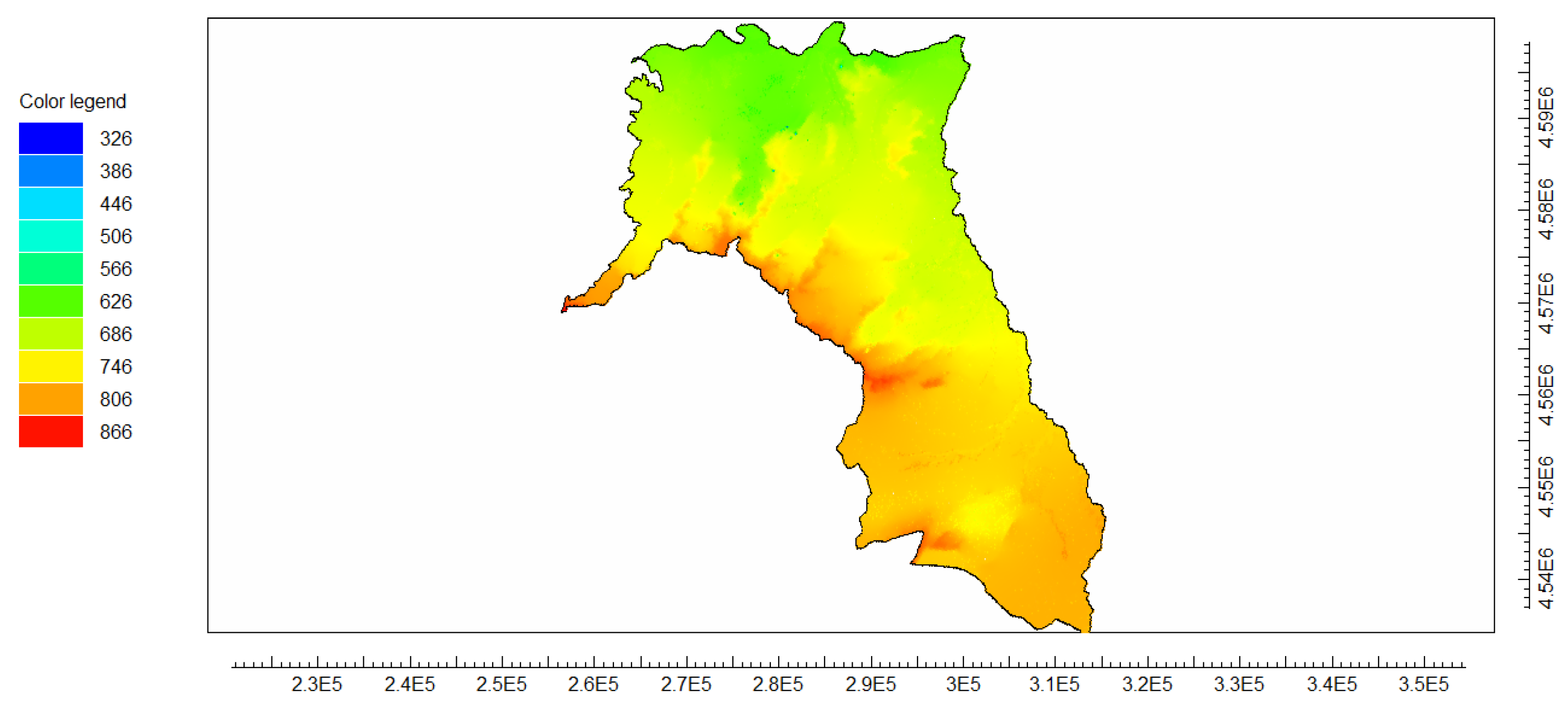
Simulation results show a generalized decline in piezometric levels under climate change conditions. In the vicinity of the study well, three situations were evaluated: current reference conditions, a climate change scenario without reduction of abstractions, and a climate change scenario incorporating the CHD restrictions. Without the implementation of management measures, the local piezometric decline reaches approximately 3.33 m, whereas with the planned reduction of abstractions the decline is limited to 1.84 m. These results indicate that although the reduction in recharge constitutes the main driver of piezometric decline, groundwater demand management exerts a significant buffering effect against climate impacts.
In addition to the local analysis at the representative agricultural well, a regional assessment of piezometric decline was conducted using the 34 monitoring points employed in the model calibration. Considering only those points where a decrease in piezometric levels is observed, the average decline across the aquifer reaches approximately 11.4 m under both analysed scenarios. This result reflects the overall response of the groundwater system to the combined effects of climate forcing and groundwater abstraction. The comparison between scenarios indicates that, although the implementation of abstraction restrictions reduces the magnitude of decline at specific locations, it does not significantly alter the average regional drawdown. This suggests that recharge reduction remains the dominant driver of piezometric decline at the aquifer scale, while management measures primarily exert a local mitigating effect.
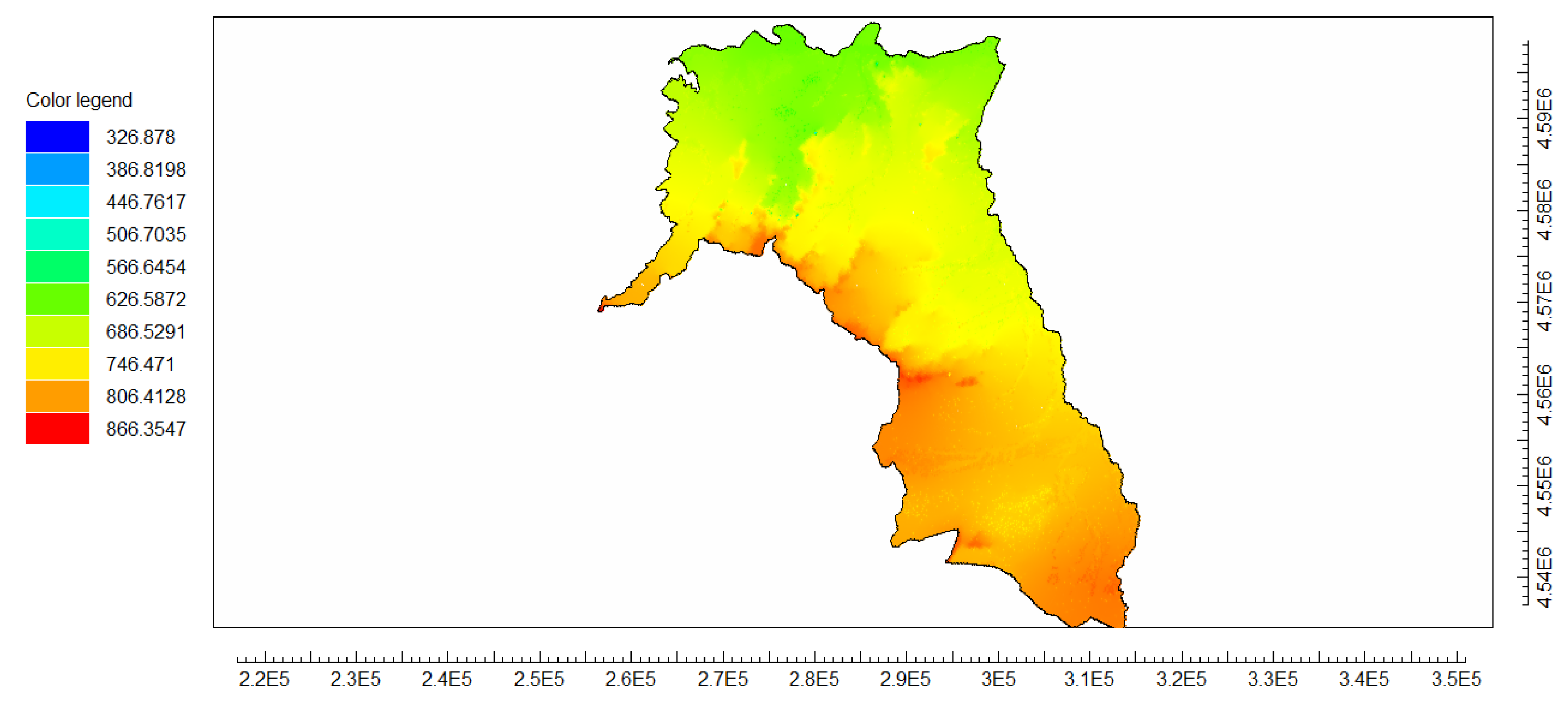
The spatial distribution of simulated piezometric levels under the different analysed conditions is shown in Figure 6, Figure 7 and Figure 8, where current reference conditions, the climate change scenario without management measures, and the scenario incorporating abstraction restrictions are compared. The results reveal a generalized decline in piezometric levels under climate forcing and a partial mitigation when pumping limitations established by CHD are incorporated.
Piezometric levels are expressed in meters above sea level (m a.s.l.). The colour scale represents the full range of simulated values across the groundwater body; therefore, some colour intervals shown in the legend may not appear in individual maps.
Projected climate change also modifies crop water requirements, as estimated with FAO CROPWAT 8.0 for Windows [26] under the regionalized future climate conditions. For the period 2040–2070, net irrigation requirements increase by approximately + 53.1 mm/year for sugar beet, + 22.5 mm/year for barley, and + 31.0 mm/year for winter wheat. These increases are consistent with the temperature rise and the altered precipitation regime projected by the multimodel ensemble used. Consequently, the local agricultural system faces a combined double effect: reduced availability of groundwater resources due to recharge decline and a simultaneous increase in irrigation demand.
Model results should be interpreted considering the inherent uncertainties associated with both hydrogeological modelling and long-term climate projections. In particular, uncertainty arises from the spatial variability of aquifer hydraulic parameters, which are highly heterogeneous and only partially constrained by available data, as well as from the simplified representation of boundary conditions. Climate projections also introduce an additional source of uncertainty due to the dispersion among general circulation models and the assumptions associated with high-emission scenarios. These factors may influence the magnitude of the simulated recharge reduction and, consequently, the piezometric response of the system. Nevertheless, the use of a physically consistent calibration approach, supported by multiple piezometric control points and robust statistical indicators, ensures that the model adequately reproduces the regional behaviour of the aquifer. Therefore, the results should be interpreted as a reliable estimation of system-scale trends rather than as precise predictions at specific locations.

4.3. Discussion and Limitations

Although the developed model reproduces the regional piezometric behaviour consistently, certain limitations inherent to the modelling of complex hydrogeological systems at regional scale must be considered.
The main source of uncertainty is related to the heterogeneity of the Tertiary detrital medium. The parameterization of hydraulic conductivity, storage coefficients, and saturated thicknesses was carried out using regional ranges and official hydrogeological descriptions, which inevitably implies a simplification of the real architecture of the multilayer aquifer. This level of conceptual abstraction is common in regional models and reflects the balance between physical representativeness and numerical stability [13,16]. However, the absence of a formal sensitivity analysis prevents the explicit quantification of the individual influence of parameters and the range of potentially equivalent alternative solutions (equifinality).
Regarding surface–subsurface interaction, the fluvial network was incorporated through distributed drainage conditions that allow the simulation of aquifer discharge when the piezometric level exceeds the defined drainage elevation. However, an explicit hydrodynamic coupling with surface flow or a transient simulation of river discharge was not implemented, resulting in a simplified representation of river–aquifer exchanges. This approach is consistent with the regional scale of the study, although it may limit the detailed reproduction of local recharge and discharge processes.
From a temporal perspective, calibration was carried out under steady-state conditions. Although a transient approach would allow a more detailed analysis of the dynamic evolution of the system, its implementation would require distributed historical series of recharge and pumping with sufficient spatial and temporal consistency, whose availability is limited at regional scale. The reconstruction of such series through additional assumptions could increase the structural uncertainty of the model.
Calibration efforts were concentrated in the area where detailed instrumental information was available, associated with the monitored agricultural well, which made it possible to integrate real hydraulic and energy data. Consequently, although the model provides a consistent regional representation, direct quantitative extrapolation to sectors with lower information density should be undertaken with caution.
As a future line of research, the incorporation of automatic calibration techniques and hybrid approaches integrating physically based modelling with artificial intelligence tools—including neural networks and “black-box” models—could enable a more exhaustive exploration of the parameter space, explicit quantification of uncertainty, and improved model fitting in environments with high structural complexity. These approaches do not replace the hydrogeological conceptual basis, but may complement traditional deterministic modelling through learning-based schemes capable of optimizing parameters and capturing nonlinear patterns that are difficult to represent through purely physical formulations.

4.4. Implications for Sustainable Management

The results obtained through numerical modelling with MODFLOW reveal the high vulnerability of the Tierra del Vino aquifer to the climatic forcing projected for the mid-21st century. The reduction in net recharge associated with the IPCC RCP 8.5 emission scenario projects a severe piezometric decline of approximately 3.33 m in the absence of intervention. This behaviour confirms the sensitivity of detrital aquifers in the Duero basin to relatively moderate reductions in natural recharge [33].
This decline is not only a physical indicator of depletion, but also a direct source of pressure on the water–energy nexus. As the water table declines, the lifting head required for pumping increases, thereby increasing the specific energy required per unit volume extracted. This physical relationship between pumping depth and energy consumption has been widely documented and is identified as a critical factor for the viability of agricultural systems [34,35].
The partial mitigation achieved through the extraction restrictions established by the CHD—which limit the local piezometric decline to approximately 1.84 m—demonstrates that administrative intervention is a necessary, but not sufficient, condition. Even under this management scenario, the downward trend in groundwater levels suggests that the system may approach an exploitation regime structurally exceeding the long-term average recharge (groundwater mining) [36,37].
These results highlight the need to move beyond static management strategies towards approaches that explicitly account for future changes in groundwater recharge. In this context, abstraction rights should be adjusted to the actual availability of water resources under climate change conditions, ensuring consistency between withdrawals and renewable resources. In particular, extraction limits should be defined to maintain the exploitation index below 0.8, taking into account both current conditions and their expected future evolution. Management strategies should also incorporate demand-side measures aimed at reducing groundwater pressure, including improvements in irrigation efficiency through system modernization, reduction of losses in distribution networks, and optimization of water application based on actual crop requirements. In operational terms, adaptive management should be linked to explicit thresholds based on both the exploitation index and observed piezometric trends. When the exploitation index reaches or exceeds 0.8, or when persistent declining piezometric trends are detected in the monitoring network, abstraction rights should be revised downward and demand-side measures should be reinforced simultaneously. The implementation of adaptive monitoring systems would also allow the definition of operational piezometric thresholds and the dynamic adjustment of pumping rates.
At the scale of the studied farm, the net water requirements of crops increase significantly under future climatic conditions: sugar beet increases from 543.9 to 597.0 mm, barley from 155.4 to 177.9 mm, and winter wheat from 209.3 to 240.3 mm. The resulting increases (on the order of 10–15%) reflect the combined effect of higher temperatures and lower effective precipitation. When these higher water demands are combined with the increase in specific pumping energy, the impact on the production system is amplified. The unit pumping energy increases and the annual energy consumption associated solely with meeting crop water requirements rises by approximately 15% under the future climate scenario.
Consequently, future hydrological planning in groundwater body 400048 must evolve towards an adaptive management approach combining dynamic allocation adjustments, strengthened monitoring networks and continuous improvement of irrigation efficiency. Only through the integration of hydrogeological management and agricultural planning will it be possible to effectively mitigate the combined effects of climate change and anthropogenic pressure on the Tierra del Vino aquifer.

5. Conclusions

This study made it possible to quantify the long-term piezometric response of the Tierra del Vino aquifer under a climate change scenario (RCP 8.5) and a management scenario based on abstraction restrictions, by means of a calibrated numerical model. The results show that recharge reduction induces a generalized piezometric decline across the system, reaching 3.33 m at the local scale in the absence of management measures. Although the abstraction restrictions proposed by the Duero River Basin Authority (CHD) reduce this impact to 1.84 m, their effect is mitigating but not sufficient on its own to prevent long-term overexploitation. In addition, the combined effect of groundwater level decline and increased crop water requirements leads to an increase of approximately 15% in irrigation energy demand. In this context, future aquifer management should move towards an adaptive approach based on projected recharge conditions, monitoring of piezometric trends, and maintaining the exploitation index below 0.8.

Author Contributions

Conceptualization, D.V.G.; methodology, D.V.G. and L.R.P.; formal analysis, D.V.G.; investigation, D.V.G., L.R.P., I.G.-B. and M.J.G.M.; data curation, D.V.G.; writing—original draft preparation, D.V.G.; writing—review and editing, L.R.P., I.G.-B. and M.J.G.M.; supervision, L.R.P., I.G.-B. and M.J.G.M. All authors have read and agreed to the published version of the manuscript.

Funding

This work was supported by the University of Valladolid Research Project VA184P24, funded by the Consejería de Educación de la Junta de Castilla y León with FEDER funds, and by Contract 061/2108331 between the University of Valladolid Foundation and the INEA Foundation.

Data Availability Statement

Some data presented in this study are available from the corresponding author upon reasonable request. Official hydrogeological and piezometric data were obtained from institutional sources cited in the manuscript. Farm-scale audit data are not publicly available due to access restrictions and because they contain site-specific operational information from a private agricultural holding.

Acknowledgments

The authors thank the Confederación Hidrográfica del Duero (CHD) for providing access to piezometric data through the MÍRAME Duero platform, as well as CEDEX for providing the climate projections from the CAMREC programme used in this study. The authors also acknowledge the support of the University of Valladolid Foundation and the INEA Foundation.

Conflicts of Interest

The authors declare no conflicts of interest.

References

  1. Vicente-Serrano, S.M. Evolution of Climate Drought Studies in Spain in Recent Decades. Geographicalia 2021, 73, 7–34. [Google Scholar] [CrossRef]
  2. Caretta, M.A.; Mukherji, A.; Arfanuzzaman, M.; Betts, R.A.; Gerten, D.; Hirabayashi, Y.; Lissner, T.K.; Gunn, E.L.; Liu, J.; Morgan, R.; et al. Water. In Climate Change 2022: Impacts, Adaptation and Vulnerability; Cambridge University Press: Cambridge, UK, 2022; pp. 551–712. [Google Scholar] [CrossRef]
  3. Scanlon, B.R.; Faunt, C.C.; Longuevergne, L.; Reedy, R.C.; Alley, W.M.; McGuire, V.L.; McMahon, P.B. Groundwater depletion and sustainability of irrigated agriculture in the US High Plains and Central Valley. Proc. Natl. Acad. Sci. USA 2012, 109, 9320–9325. [Google Scholar] [CrossRef] [PubMed]
  4. Faunt, C.C. (Ed.) Groundwater Availability of the Central Valley Aquifer, California; U.S. Geological Survey Professional Paper 1766; U.S. Geological Survey: Reston, VA, USA, 2009; 227p. [CrossRef]
  5. Du, J.; Laghari, Y.; Wei, Y.-C.; Wu, L.; He, A.-L.; Liu, G.-Y.; Yang, H.-H.; Guo, Z.-Y.; Leghari, S.J. Groundwater Depletion and Degradation in the North China Plain: Challenges and Mitigation Options. Water 2024, 16, 354. [Google Scholar] [CrossRef]
  6. Confederación Hidrográfica del Duero. MÍRAME-Duero Viewer: Hydrogeological and Piezometric Information. Official Data Portal. 2026. Available online: https://mirame.chduero.es/chduero/ (accessed on 20 January 2026).
  7. Sahuquillo, A.; Custodio, E.; Llamas, M.R. Groundwater Management; Technical Report; Scientific and Technical Panel for Water Policy Monitoring, University of Seville–Spanish Ministry of Environment: Seville, Spain, 2009; p. 9. [Google Scholar]
  8. De la Hera-Portillo, A.; López-Gutiérrez, J.; Mayor, B.; López-Gunn, E.; Henriksen, H.J.; Gejl, R.N.; Zorrilla-Miras, P.; Martínez-Santos, P. An Initial Framework for Understanding the Resilience of Aquifers to Groundwater Pumping. Water 2021, 13, 519. [Google Scholar] [CrossRef]
  9. Jiménez Cisneros, B.E.; Oki, T.; Arnell, N.W.; Benito, G.; Cogley, J.G.; Döll, P.; Jiang, T.; Mwakalila, S.S. Freshwater Resources. In Climate Change 2014: Impacts, Adaptation, and Vulnerability; Cambridge University Press: Cambridge, UK, 2014; pp. 229–269. [Google Scholar]
  10. Shah, T.; Scott, C.; Kishore, A.; Sharma, A. Energy-Irrigation Nexus in South Asia: Improving Groundwater Conservation and Power Sector Viability, 2nd ed.; Research Report 70; International Water Management Institute: Colombo, Sri Lanka, 2004. [Google Scholar]
  11. Corominas, J. Agua y energía en el riego en la época de la sostenibilidad. Ing. Agua 2009, 17, 219–233. [Google Scholar]
  12. van Vuuren, D.P.; Edmonds, J.; Kainuma, M.; Riahi, K.; Thomson, A.; Hibbard, K.; Hurtt, G.C.; Kram, T.; Krey, V.; Lamarque, J.-F.; et al. The Representative Concentration Pathways: An Overview. Clim. Change 2011, 109, 5–31. [Google Scholar] [CrossRef]
  13. Anderson, M.P.; Woessner, W.W.; Hunt, R.J. Applied Groundwater Modeling: Simulation of Flow and Advective Transport, 2nd ed.; Academic Press: San Diego, CA, USA, 2015. [Google Scholar]
  14. Pulido-Velazquez, D.; García-Aróstegui, J.L.; Molina, J.L.; Pulido-Velazquez, M. Assessment of Future Groundwater Recharge in Semi-Arid Regions Under Climate Change Scenarios. Hydrol. Process. 2015, 29, 828–844. [Google Scholar] [CrossRef]
  15. Confederación Hidrográfica del Duero. Hydrological Plan of the Spanish Part of the Duero River Basin District 2022–2027; Technical Report; Spanish Ministry for Ecological Transition and Demographic Challenge: Valladolid, Spain, 2023. [Google Scholar]
  16. Instituto Geológico y Minero de España. Hydrogeological Characterisation of the Tierra del Vino Groundwater Body; Technical Report; IGME-CSIC: Madrid, Spain, 2022. [Google Scholar]
  17. Confederación Hidrográfica del Duero. La Masa de Agua Subterránea Tierra del Vino (400048); Technical Report; Duero River Basin Authority: Valladolid, Spain, 2014. [Google Scholar]
  18. Confederación Hidrográfica del Duero. Technical Sheet of Groundwater Body 400048–Tierra del Vino; MÍRAME-IDEDuero Information System: Valladolid, Spain, 2026. [Google Scholar]
  19. Confederación Hidrográfica del Duero. Annex 5: Water Demands. Appendix III: Irrigation Use Methodology; Technical Report; Hydrological Plan 2015–2021; Spanish Ministry of Agriculture, Food and Environment: Valladolid, Spain, 2015. [Google Scholar]
  20. Harbaugh, A.W. MODFLOW-2005, The U.S. Geological Survey Modular Ground-Water Model; Technical Report 6-A16; U.S. Geological Survey: Reston, VA, USA, 2005.
  21. Langevin, C.D.; Hughes, J.D.; Banta, E.R.; Niswonger, R.G.; Panday, S.; Provost, A.M. Documentation for the MODFLOW 6 Groundwater Flow Model; Technical Report Techniques and Methods 6-A55; U.S. Geological Survey: Reston, VA, USA, 2017. [CrossRef]
  22. Winston, R.B. ModelMuse Version 4: A Graphical User Interface for MODFLOW 6; Technical Report Scientific Investigations Report 2019-5036; U.S. Geological Survey: Reston, VA, USA, 2019. [CrossRef]
  23. Instituto Geológico y Minero de España (IGME). Piezometric Monitoring Network and Groundwater Level Data. Official Groundwater Level Database. 2025. Available online: https://catalogo.igme.es/geonetwork/srv/api/records/ESPIGMEPUNTOSAGUA20190723 (accessed on 20 January 2026).
  24. IPCC. Climate Change 2013: The Physical Science Basis. Contribution of Working Group I to the Fifth Assessment Report of the Intergovernmental Panel on Climate Change; Cambridge University Press: Cambridge, UK; New York, NY, USA, 2013. [Google Scholar]
  25. CEDEX. Assessment of Climate Change Impacts on Water Resources and Droughts in Spain; Technical Report; Centro de Estudios y Experimentación de Obras Públicas: Madrid, Spain, 2017. [Google Scholar]
  26. FAO. CROPWAT 8.0 for Windows: Software for Crop Water Requirements and Irrigation Scheduling; FAO: Rome, Italy, 2009. [Google Scholar]
  27. Toure, A.; Diekkrüger, B.; Mariko, A. Impact of Climate Change on Groundwater Resources in the Klela Basin, Southern Mali. Hydrology 2016, 3, 17. [Google Scholar] [CrossRef]
  28. Instituto Geológico y Minero de España. Hydrogeological Map of Spain 1:200,000. Sheet 37 Salamanca; Technical Report; Lithostratigraphic Base Used for Model Layer Definition; Ministry of Industry and Energy: Madrid, Spain, 1982.
  29. McDonald, M.G.; Harbaugh, A.W. A Modular Three-Dimensional Finite-Difference Ground-Water Flow Model. In Techniques of Water-Resources Investigations Book 6, Chapter A1; U.S. Geological Survey: Reston, VA, USA, 1988. [Google Scholar]
  30. Cabrera-Estupiñán, E.; Hernández-Valdés, A. Modelación del agua subterránea a escala regional con refinamiento local de la malla: Planteamiento y validación del algoritmo. Tecnol. Cienc. Agua 2011, 2, 65–82. Available online: http://www.scielo.org.mx/scielo.php?script=sci_arttext&pid=S2007-24222011000100005&lng=es&nrm=iso (accessed on 1 May 2026).
  31. Moriasi, D.N.; Gitau, M.W.; Pai, N.; Daggupati, P. Hydrologic and Water Quality Models: Performance Measures and Evaluation Criteria. Trans. ASABE 2015, 58, 1763–1785. [Google Scholar] [CrossRef]
  32. Nash, J.E.; Sutcliffe, J.V. River Flow Forecasting Through Conceptual Models Part I—A Discussion of Principles. J. Hydrol. 1970, 10, 282–290. [Google Scholar] [CrossRef]
  33. Olcina Cantos, J. Water Planning and Management in Spain in a Climate Change Context: Facts and Proposals. Cuad. Investig. Geogr. 2024, 50, 3–28. [Google Scholar] [CrossRef]
  34. FAO. Energy-Smart Food for People and Climate; Technical Report; Food and Agriculture Organization of the United Nations: Rome, Italy, 2011. [Google Scholar]
  35. Albiac, J.; Esteban, E.; Tapia, J.; Kahil, T. Economics of Irrigation Water Management; Water Resources Management and Policy; Springer: Cham, Switzerland, 2023. [Google Scholar]
  36. Alley, W.M.; Reilly, T.E.; Franke, O.L. Sustainability of Ground-Water Resources; Technical Report 1186; U.S. Geological Survey: Denver, CO, USA, 1999.
  37. Custodio, E. Aquifer Overexploitation: What Does It Mean? Hydrogeol. J. 2002, 10, 254–277. [Google Scholar] [CrossRef]
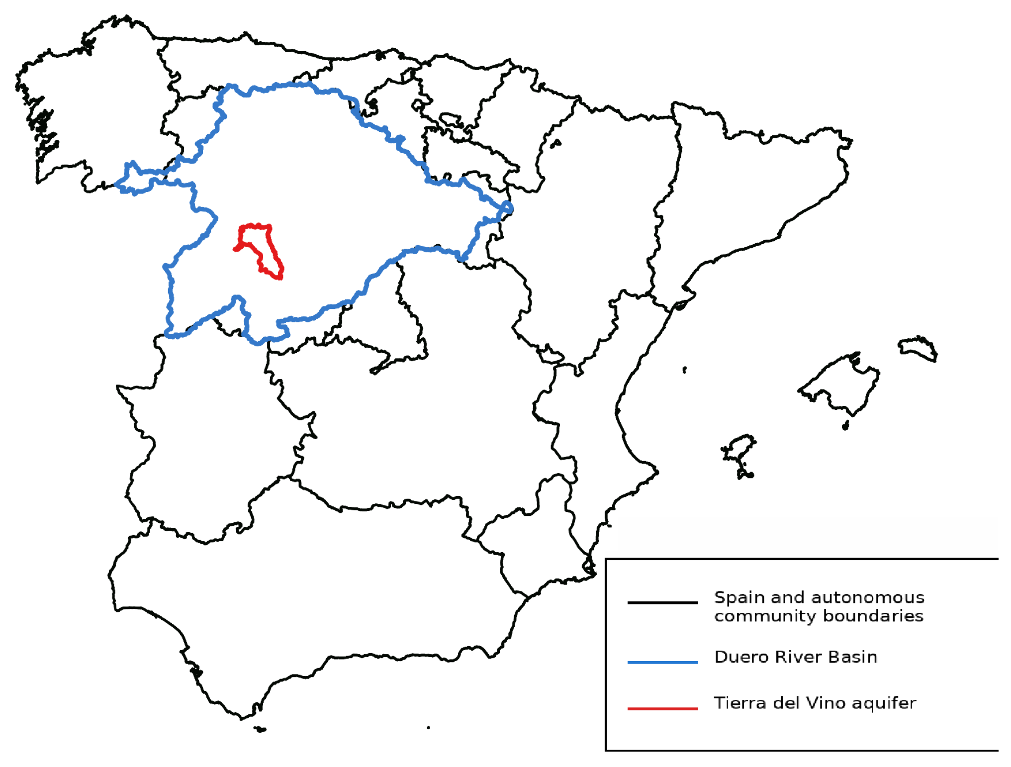
Figure 1. Regional location of the Tierra del Vino aquifer within Spain and the Duero River Basin. The map shows the administrative boundaries of Spain, the extent of the Duero River Basin, and the location of the Tierra del Vino aquifer.
Water 18 01163 g001
Figure 2. Spatial characteristics of the Tierra del Vino aquifer. Digital elevation model and drainage network of the study area. Spatial distribution of groundwater abstraction wells. Location of the agricultural pumping well used for the agricultural analysis. Distribution of the piezometric monitoring points used for groundwater model calibration.
Water 18 01163 g002
Figure 3. Conceptual hydrogeological cross-section of the Tierra del Vino aquifer system showing the main stratigraphic units and groundwater levels (adapted from the Duero River Basin Authority documentation) [17].
Water 18 01163 g003
Figure 4. Spatial discretization of the model domain and grid layout over groundwater body MASub 400048.
Water 18 01163 g004
Figure 5. Graphical PM validation showing the convergence between modelled elevation and observed elevation, supporting the validity of the model for climate scenario simulations.
Water 18 01163 g005
Figure 6. Spatial distribution of simulated piezometric levels (m a.s.l.) in the Tierra del Vino groundwater body under current reference conditions (2021).
Water 18 01163 g006
Figure 7. Spatial distribution of simulated piezometric levels (m a.s.l.) under the climate change scenario (RCP 8.5, period 2040–2070) without abstraction restrictions.
Water 18 01163 g007
Figure 8. Spatial distribution of simulated piezometric levels (m a.s.l.) under the climate change scenario incorporating the abstraction restrictions planned by CHD.
Water 18 01163 g008
Disclaimer/Publisher’s Note: The statements, opinions and data contained in all publications are solely those of the individual author(s) and contributor(s) and not of MDPI and/or the editor(s). MDPI and/or the editor(s) disclaim responsibility for any injury to people or property resulting from any ideas, methods, instructions or products referred to in the content.