Article

Suitability Evaluation of Ecological Restoration Relying on Water Resources in an Agro-Pastoral Transition Zone: A Case Study of Zhangbei, Zhangjiakou, Northern China

1
Tianjin Center, China Geological Survey (North China Center of Geoscience Innovation), Tianjin 300170, China
2
Xiongan Urban Geological Research Center, China Geological Survey, Tianjin 300170, China
3
Tianjin Key Laboratory of Coast Geological Processes and Environmental Safety, Tianjin 300170, China
4
Tianjin Institute of Geological Survey, Tianjin 300191, China
*
Authors to whom correspondence should be addressed.
Water 2025, 17(9), 1393; https://doi.org/10.3390/w17091393
Submission received: 20 March 2025 / Revised: 2 May 2025 / Accepted: 4 May 2025 / Published: 6 May 2025
(This article belongs to the Special Issue Wetland Conservation and Ecological Restoration)

Abstract

:
(1) Background: Ecological restoration is crucial to improve ecological functions and optimize its security patterns. The Zhangbei of Zhangjiakou, a typical agro-pastoral transition zone, was studied as an example to conduct ecological restoration suitability evaluation in northern China. (2) Methods: suitability of ecological restoration in Zhangbei was assessed by both single factor analysis and comprehensive factor analysis, which were based on the data of regional water resources, ecosystem service function, and ecosystem sensitivity obtained from a high-precision environmental survey. (3) Results and conclusions: The results show that in Zhangbei County, areas classified as important and extremely important for ecosystem service functions account for 50.32%, ecologically sensitive and highly sensitive areas represent 5.95%, and regions designated as important and extremely important for ecological protection cover 52.70%. Furthermore, ecological restoration of Zhangbei was divided into four ecological restoration zones: agro-forest–wetland ecological restoration and soil erosion control zone, agro-forest–wetland ecological restoration and water conservation zone, forest–grassland soil erosion and soil–water conservation zone, and mountain forest conservation and biodiversity maintenance zone. The study can be a scientific case study for local ecosystem restoration and conservation. In the future, this study will further explore multi-source data fusion, the establishment of a multi-scale evaluation system, and the trade-off analysis between conservation and development.

1. Introduction

Rapid development of the regional economy encouraged steadily accelerated urban expansion, which caused noticeable ecological issues due to overuse of various spatial resources [1]. The sustainable growth of regional ecological security has been impacted by ongoing human activity [2,3]. Thus, targeted regional ecological protection and restoration is desired to reduce the current severe trend of ecological and environmental deterioration [4,5].
Foreign studies in this field originated from early 20th century land evaluation theories [6], followed by the enactment of a series of laws, regulations, and “restoration programs” [7,8,9,10,11,12]. In the United States, the “Land Suitability Classification” method, initially developed for agricultural productivity assessment, was later extended to ecological restoration, emphasizing climate adaptability and species selection [13]. European scholars prioritize ecosystem service value assessment, using outcome benefit analysis to determine restoration priorities. For instance, Germany integrates carbon sequestration functions into evaluation criteria [14]. Japan developed comprehensive models combining geographic positioning and ecological functions, promoting the optimization of agroforestry systems [15]. In recent years, global-scale ecological restoration research shifted toward interdisciplinary approaches, such as quantifying ecological carrying capacity using the the InVEST model and enhancing the feasibility of restoration plans through community engagement mechanisms [16].
Since the 1950s, more and more ecological restoration projects were carried out in China, and abundant theoretical methodologies [17,18,19,20], technical specifications [21], and real cases [22,23,24,25,26,27] were accumulated gradually. Cai et al. [28] introduced a way of ecological restoration regionalization based on dominant functional features, such as regional land, ecological, and economic functions. These methods were based on the fundamental theories of land planning and ecological civilization construction, such as “life community theory” and “suitability and management.” Yu et al. [29] proposed regional land comprehensive remediation measures, which supports the idea of coupling supply and demand, including a whole-process “1 + 1 + X” global remediation land space planning system, multi-disciplinary natural resource value potential, and global remediation performance evaluation methods. Overall, current evaluation methods on ecological restoration mostly rely on individual parameters, such as ecological security patterns, ecological sensitivity, and ecosystem service function [30,31]. Nevertheless, there were few studies based on two or more parameters, and they mostly carried on within a large scale. It is necessary to attempt the comprehensive management at local regional levels with multiple parameters.
The agro-pastoral ecotone refers to a transitional zone between traditional agriculture and animal husbandry, widely distributed in northern China and serving as a critical ecological barrier for the region [28]. However, due to its inherently fragile natural environment and the rapid growth of the population and economy, the natural resources and ecological conditions in this area have been increasingly deteriorating [32,33,34,35,36,37,38]. For instance, the Grain for Green program (conversion of cropland to forest and grassland) implemented on the Loess Plateau failed to adequately account for regional differences in precipitation and soil conditions, resulting in suboptimal ecological restoration outcomes in certain areas. Zhangjiakou’s Zhangbei County, a typical agro-pastoral ecotone in northern China, simultaneously fulfills multiple environmental service functions, including biodiversity conservation, carbon sequestration, agricultural and pastoral resource production, and eco-tourism. Such areas often lie in zones where ecological fragility overlaps with high service value, and their restoration outcomes will directly shape the regional ecological security pattern. Since the year 2000, the implementation of the Bashang Project for Returning Farmland to Forests and Grasslands positively impacted local ecological restoration [35]. However, conflicts persist between ecological preservation and economic development, urgently necessitating research on ecological protection and restoration. This research should optimize regional ecological security spatial patterns, comprehensively address environmental issues, and enhance ecosystem service functions in the area.
Therefore, this study selects Zhangbei County as the research area to establish a comprehensive evaluation system integrating water conservation, soil and water retention, biodiversity maintenance, and windbreak sand fixation functions. A progressive “function-sensitivity-protection level” framework is developed, utilizing high-precision environmental geological data and provincial “dual evaluation” (ecological–environmental and agricultural–production suitability assessments) outcomes for multi-scale collaboration. Sensitivity classification criteria are formulated based on hydraulic and wind erosion intensity. Through a “preliminary judgment-coordination-correction” verification mechanism, multi-source data, including ecological corridors, geomorphic integrity, and protected area planning, are integrated to create a refined ecological protection zoning methodology.
This approach provides an integrated “assessment-protection-restoration” technical solution for ecologically fragile agro-pastoral ecotones in northern China, addressing the fragmentation of traditional planning elements. It precisely supports the optimization of Zhangbei’s ecological redline delineation and territorial spatial governance, offering a replicable paradigm for constructing ecological security patterns in similar counties across China. The methodology innovatively bridges ecological sensitivity analysis with practical conservation needs, enabling data-driven decision-making for balancing ecological resilience and sustainable development in vulnerable regions.

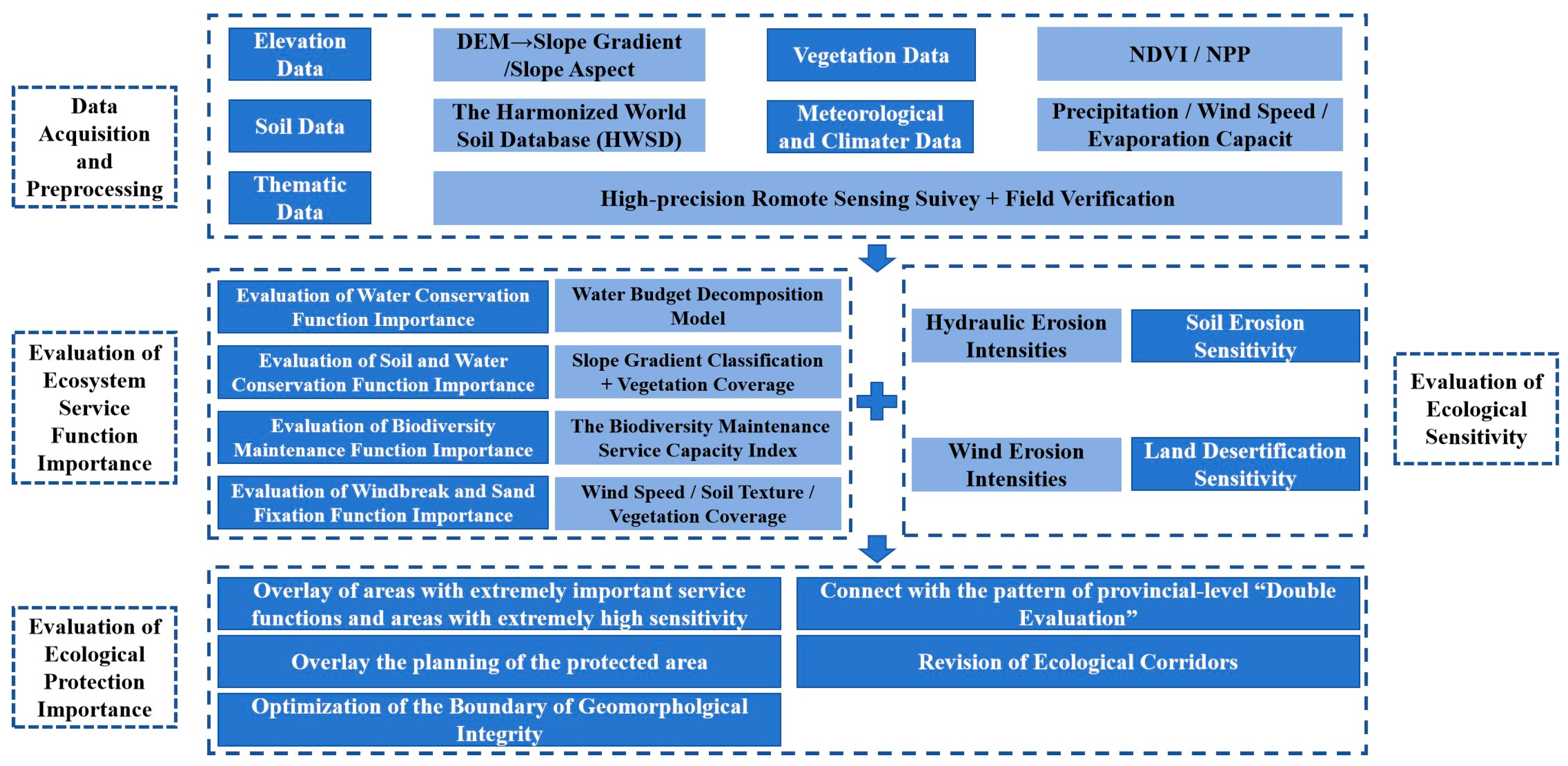
2. Materials and Methods
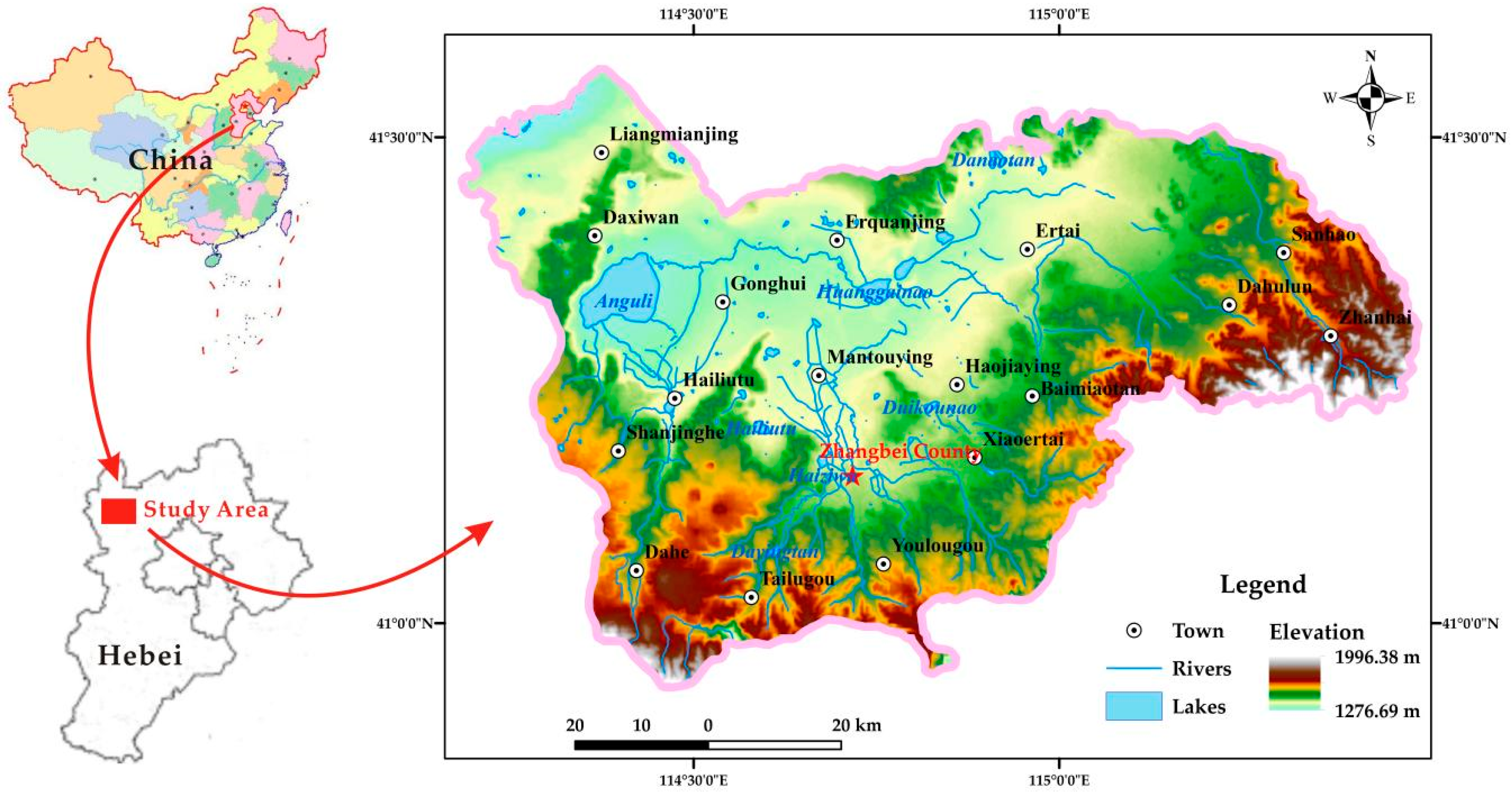
2.1. The Study Area

Zhangbei is situated in the Bashang region of the Inner Mongolia Plateau in northwestern Hebei Province (Figure 1). The terrain is predominantly characterized by plains and hills, with elevations sloping downward toward the central area and rising in the southern and northern parts [39]. The altitude is 1200~2000 m above sea level, and the climate belongs to the temperate continental grassland zone, with approximately 400 mm of annual precipitation. The Anguli Lake Basin hosts an extensive network of 25 rivers, with a total length of 793 km. Most rivers originate from the hilly uplands of the dam and flow from south to north. These waterways are typically short, with gentle gradients, and most terminate into onshore basins, and a few flow into inland depressions. The ground surface is highly unstable here due to its thick loose sedimentary layers of quaternary, particularly widespread aeolian sand and loess, which causes the land to become exceptionally vulnerable from wind and water erosion. As a result, desertification and degradation of forest and grassland ecosystems are chiefly environmental challenges in this region.

2.2. Data Sources

2.2.1. Basic Data

The selection of data sources in this study adheres to principles of scientific rigor, authoritative credibility, and spatiotemporal consistency. The specific data elements and their selection rationale are detailed below (Table 1):
Digital elevation model (DEM) data were employed to derive slope and aspect parameters (sourced from the Geographic Spatial Data Cloud Platform, Chinese Academy of Sciences [40], whose 30 m resolution ensures precision for county scale analysis). Normalized difference vegetation index (NDVI) values were obtained from MODIS satellite products (MOD13Q1), with NASA’s global validation network calibration enabling accurate reflection of interannual vegetation coverage variations [41]. Net primary productivity (NPP) data were selected from the GLASS dataset, which mitigates single-sensor errors through multi-source remote sensing integration [42]. Soil characteristic parameters were derived from the China subset (V1.1) of the Harmonized World Soil Database (HWSD), containing critical 0–100 cm soil layer organic matter metrics after localization calibration by China Agricultural University researchers, meeting ecological carrying capacity modeling requirements. Meteorological data were acquired from the China Meteorological Science Data Sharing Service Network, utilizing monthly raster datasets (2000–2020) with 1 km×1 km spatial resolution, whose observation point density (2419 nationwide stations) demonstrates high spatial congruence with the agro-pastoral ecotone study area.

2.2.2. High-Resolution Environmental Geological Survey of Agro-Pastoral Transition Zone

A high-resolution environmental geology survey of the agro-pastoral transition zone in the study area was conducted by field validation, supported by high-resolution remote sensing imagery. Accordingly, land degradation in Zhangbei is mainly due to saline–alkaline desertification, with a total area of 314.60 km2 in 2020, including 216.28 km2 with light degree, 39.55 km2 with moderate degree, and 58.77 km2 with severe degree. The total grassland of this area is 753.07 km2, including 62.40 km2 as heavily salinized, 211.73 km2 as salinized grassland, and 582.33 km2 usable grassland.

2.3. Evaluation of Ecosystem Service Function Importance

To safeguard regional ecological security, this study employs land use suitability and resource-carrying capacity frameworks. Namely, it evaluates the ecological functions (e.g., biodiversity maintenance, windbreak and sand fixation, and water–soil conservation) and the ecological sensitivity (e.g., soil erosion and land desertification risks) of the study area. The importance of the degree of ecosystem services functions is generated from spatially integrating the evaluation results of four critical items, including water conservation, soil retention, biodiversity preservation, and windbreak sand fixation.

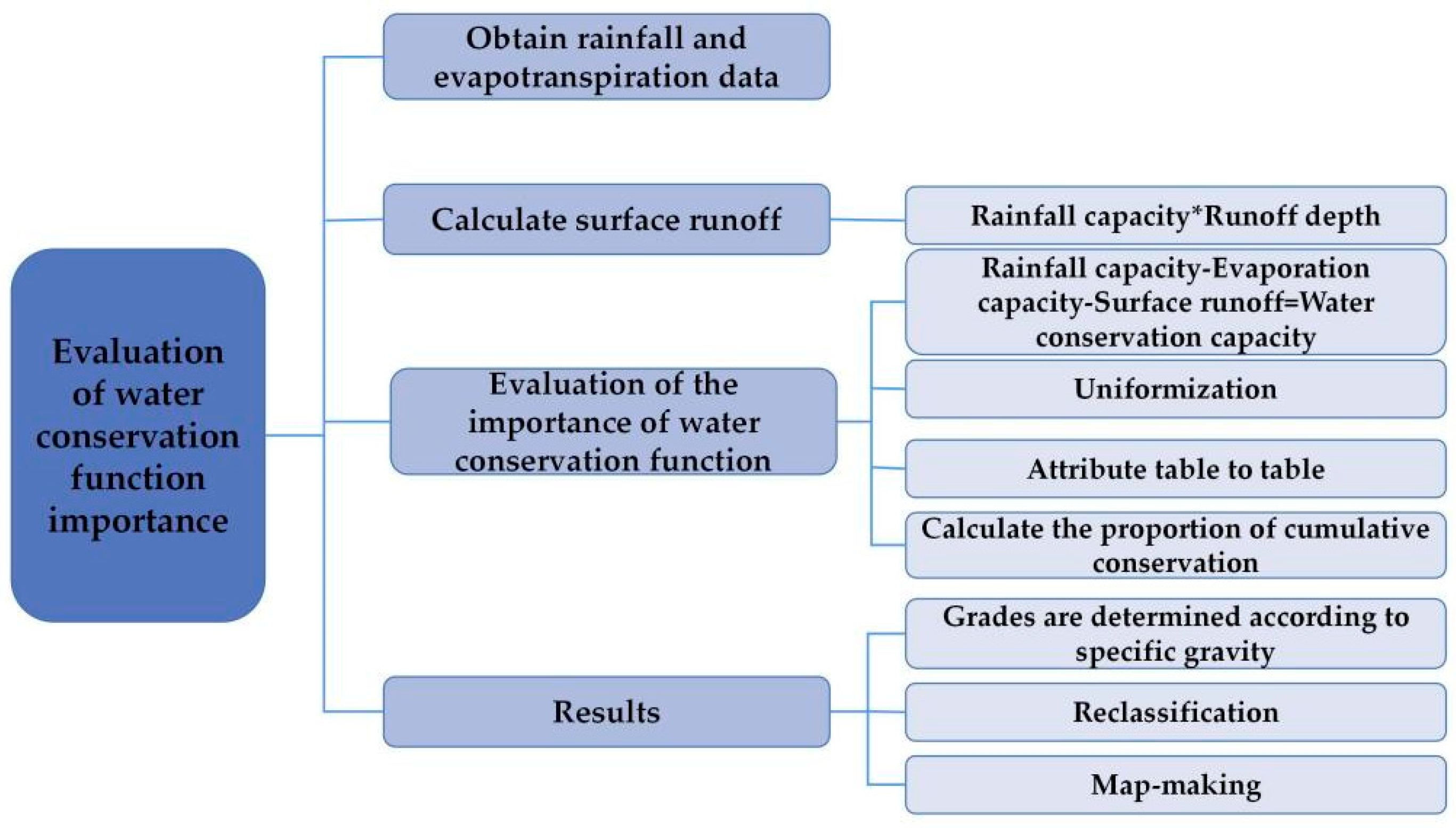
2.3.1. Evaluation of Water Conservation Function Importance

Water conservation refers to the capacity of ecosystems (e.g., forests, grasslands) to regulate hydrological cycles by intercepting, infiltrating, and storing precipitation through their structural features. Following the Ecological Conservation Redline Delineation Guidelines [43], this study evaluates water conservation capacity by a water budget decomposition model that partitions precipitation and evapotranspiration (Figure 2). Generally, grid-based water conservation values are ranked from highest to lowest. The next step includes calculating the cumulative values and identifying thresholds at 50% and 80% of the cumulative value, and finally, classifying water conservation importance into three degrees: critically important, important, and generally important, based on the thresholds identified.

2.3.2. Evaluation of Soil and Water Conservation Function Importance

Soil and water conservation refers to the capacity of ecosystems (e.g., forests, grasslands) to mitigate soil erosion from water flow by their structural and functional processes, serving as a critical regulatory ecosystem service [43]. Slopes are generally gentle in Zhangbei, so slope gradients were classified into three degrees from the steepest to the gentlest by the natural breaks method (Table 2). For example, the critically important zones are characterized with the steepest slopes and vegetation coverage greater than or equal to 60%; and important zones are characterized with generally steep slopes and vegetation coverage greater than or equal to 20%.

2.3.3. Evaluation of Biodiversity Maintenance Function Importance

The biodiversity maintenance function refers to an ecosystem’s capacity to sustain genetic, species, and ecosystem diversity, and it is one of its most critical functions. This study employs the net primary productivity (NPP) method to assess biodiversity maintenance importance by the biodiversity maintenance service capacity index (Sbio). At first, grid-based service values are ranked from highest to lowest and then the cumulative values are computed. Next, critical thresholds at 50% and 80% of the total cumulative ecosystem service values are identified. Finally, biodiversity maintenance is classified into three categories: critically important, important, and generally important.
S b i o = N P P m e a n × F p r e × F t e m × 1 F a l t
where S b i o is the biodiversity maintenance service capability index; N P P m e a n is the multi-year average of vegetation; F p r e is the normalized precipitation factor; F t e m is the normalized temperature factor; and F a l t is the normalized elevation factor.

2.3.4. Evaluation of Windbreak and Sand Fixation Function Importance

Windbreak and sand fixation function refers to the capacity of ecosystems (e.g., forests, grasslands) to mitigate soil erosion from wind by their structural and functional processes, serving as a vital regulatory ecosystem service. This study assesses the importance of the windbreak sand fixation function from the windbreak and sand fixation service capacity index (SWS). Accordingly, it can be classified into critically important zones and important zones. The critically important zones are the areas with annual precipitation < 400 mm, strong wind speeds, gentle slopes (<5°), and sandy soils, also including built-up land and gobi desert with vegetation cover <20%. The important zones are the areas with precipitation ≤ 60% of regional averages, moderate wind speeds, steeper slopes (>5°), and saline soils, also including farmland and water bodies vegetation cover ≥10%. The formula for the windbreak and sand fixation service capacity index (SWS) is calculated as follows:
S W S = N P P m e a n × K × F q × D
F q = 1 100 i = 1 12 u 3 E T P i P i E T P i × d
E T P i = 0.19 20 + T i × 1 r i
u 2 = u 1 z 2 / z 1 1 / 7
D = 1 / cos θ
where S W S is the windbreak and sand fixation service capacity index, K is the soil erodibility factor, F q is the multi-year average climate erosivity factor, D is the surface roughness factor, u is the monthly average wind speed at a height of 2 m, and u 1 , u 2 is the wind speed at a height of z 1 , z 2 , E T P i is the monthly potential evaporation (mm), P i is the monthly precipitation (mm), d is the number of days in the month, T i is the monthly average temperature (°C), r i is the monthly average relative humidity (%), and θ is the slope (°).

2.4. Evaluation of Ecological Sensitivity

Soil erosion sensitivity and land desertification sensitivity were classified into two levels: highly sensitive and sensitive, with the highest sensitivity level of all factors determining the final ecological sensitivity rating. According to high-resolution environmental geological survey data from the agro-pastoral transition zone in Zhangbei, the area with severe and extremely severe hydraulic/wind erosion intensities was classified into highly sensitive; the area with intense and moderate erosion levels was classified into sensitive.

2.5. Evaluation of Ecological Protection Importance

The preliminary delineation of the critically important zones of ecological protection was determined by overlaying and integrating areas both with critically important in ecosystem service function and highly sensitive, identified by ecological sensitivity evaluations. Afterwards, the results were aligned with the province evaluation result to ensure consistency in regional ecological planning frameworks. Further refinements were applied with consideration of protected area plans: designated conservation zones in Zhangbei; ecological corridors: habitats of rare and endangered species; and geoenvironmental integrity: landscape features, geographical coherence, and ecosystem continuity. Key references for refining the preliminary critically important zones included the following: ecological core areas (3 sites); scenic landscapes (1 site); geoparks (1 site); water source protection zones (1 site); and inland wetlands (Figure 3).

2.6. Principles for Naming Ecological Restoration Zones

The ecological restoration zoning framework for Zhangbei was developed with single-factor analysis and comprehensive multi-factor analysis by GIS spatial clustering techniques to identify regional advantages and classify land ecosystem types. There were two conventions for the classification of the ecological restoration zone: ecosystem subsystem and dominant ecological function/sensitivity/environmental issue. The ecosystem subsystem included forest, grassland, farmland, and urban areas; the environmental features included drinking water source protection, wetland degradation, and critical geological heritage sites; and the ecological functions/sensitivities included water conservation, soil retention, biodiversity preservation, wind erosion control, soil erosion sensitivity, and land desertification. The final nomenclature prioritizes regionally dominant or representative characteristics, ensuring alignment with local ecological priorities and restoration objectives.

3. Results and Discussion

Although the core methodology of this study relies on remote sensing technology, stratified sampling surveys were conducted in key sensitive areas of the research region, collecting soil samples, groundwater, and surface water samples. These data were cross-verified with ground-based observations from references [36,44,45,46], leading to the following results.

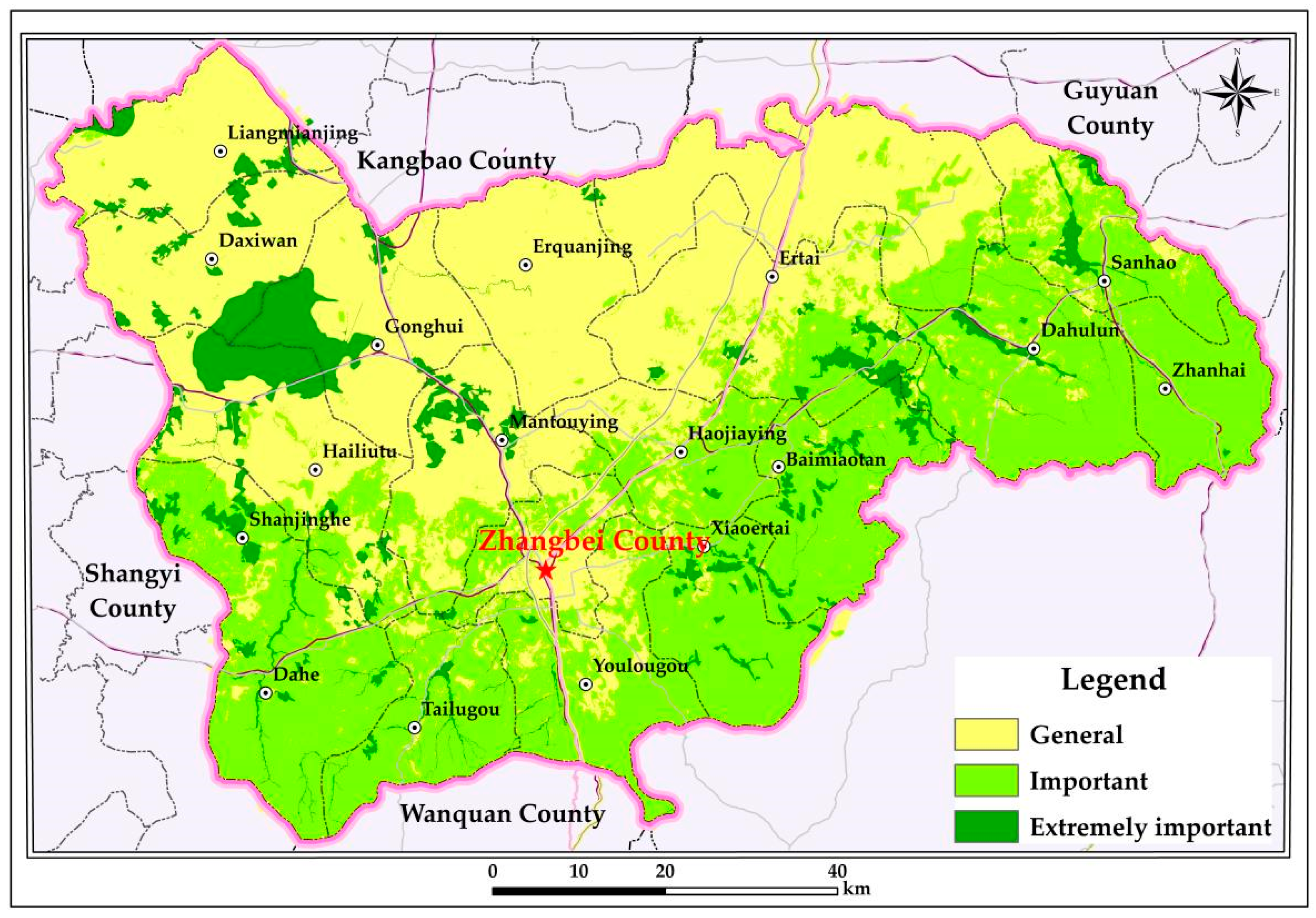
3.1. Evaluation Results of Ecological Service Function Importance

Accordingly, the water conservation function, soil and water conservation function, biodiversity maintenance function, and windbreak and sand fixation function of Zhangbei were assessed (Figure 2, Table 3), and then a composite ecological service importance classification integrating from four functional evaluations was generated (Figure 4).

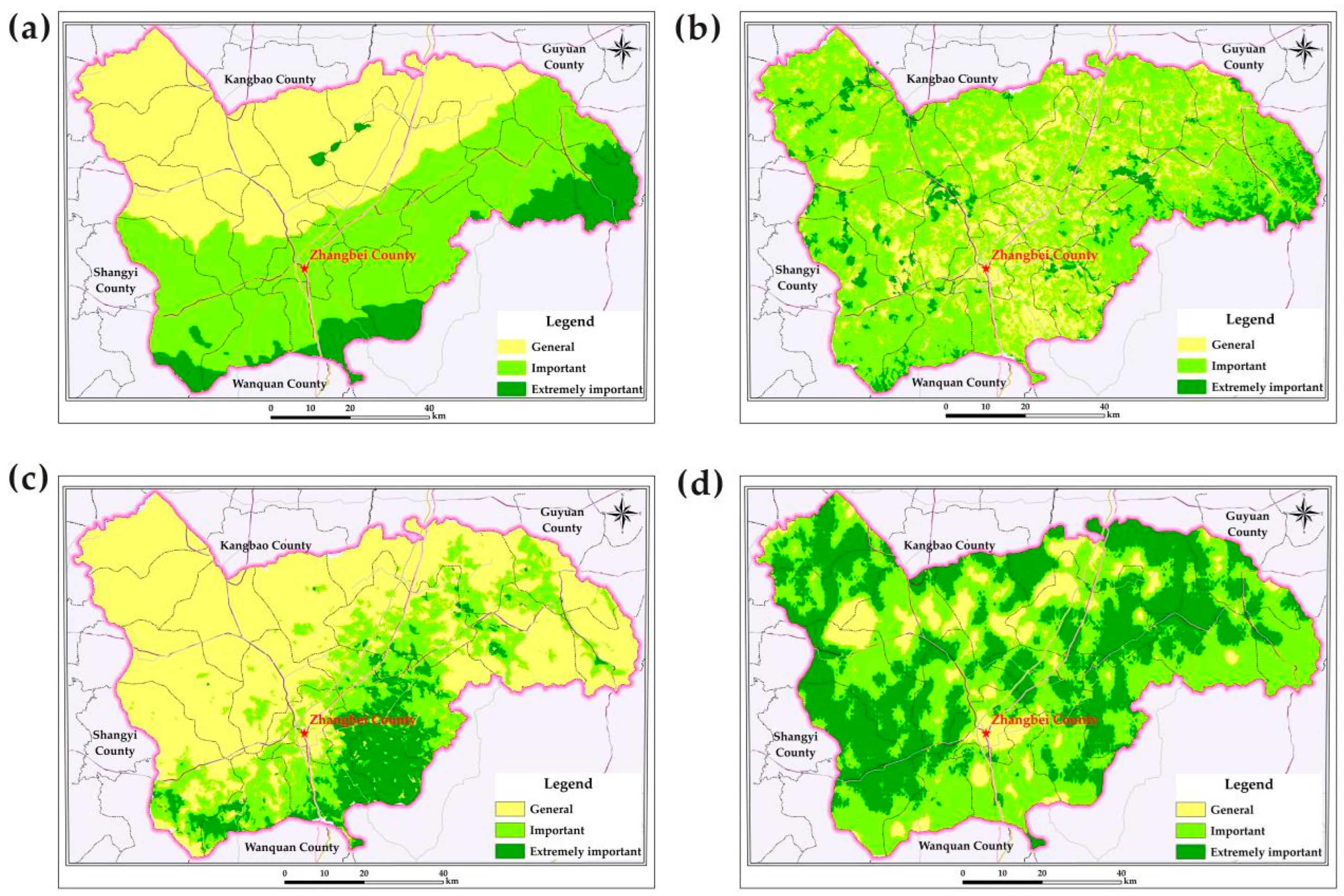
3.1.1. Evaluation Results of Water Conservation Function Importance

Water conservation refers to the capacity of ecosystems (e.g., forests, grasslands) to regulate hydrological cycles through their structural and functional interactions with water. This involves intercepting, infiltrating, and storing precipitation while modulating water flow and distribution via evapotranspiration. It includes mitigating surface runoff, replenishing groundwater, moderating seasonal river discharge fluctuations, regulating floodwaters and sustaining baseflow during dry periods, and maintaining water quality. In Zhangbei, according to the evaluation, the critically important zones for water conservation cover approximately 445.53 km2 (10.31% of the total area; Table 3), and are primarily concentrated in southern Zhangbei, and surround the Huanggainao Lake in the north (Figure 4a). Important zones cover 1951.45 km2 (45.17%), while generally important zones cover 1923.71 km2 (44.52%).

3.1.2. Evaluation Results of Soil and Water Conservation Function Importance

Soil and water conservation refers to the capacity of ecosystems (e.g., forests, grasslands) to mitigate soil erosion caused by water flow. In the study area, due to an average elevation of 1400~1600 m and favorable hydrothermal conditions, vegetation is dominated by forestland and pasture (Figure 4b), resulting in robust soil retention capabilities. Consequently, both the critically important and the important zones cover 75.45% of the total area (Table 3), and the critically important zones span 302.86 km2 (7.01%) and the important zones span 2957.12 km2 (68.44%). The generally important zones span 1060.71 km2 (24.55%).

3.1.3. Evaluation Results of Biodiversity Maintenance Function Importance

Biodiversity maintenance function encompasses the role of an ecosystem in preserving genetic, species, and ecosystem diversity. In the study area, the critically important zones for biodiversity conservation cover 495.72 km2 (11.47%; Table 3), concentrated around the Xiao’ertai town in eastern Zhangbei (Figure 4c). The important zones cover 1004.93 km2 (23.26%), while generally important zones dominate the northwestern region, accounting for 2820.04 km2 (65.27%).

3.1.4. Evaluation Results of Windbreak and Sand Fixation Function Importance

Windbreak and sand fixation function refers to ecosystems’ capacity to reduce soil erosion driven by wind. In Zhangbei, the critically important zones for windbreak sand fixation span 1753.13 km2 (40.58% of the total area), distributed ubiquitously across the region (Figure 4d, Table 3). The important zones span 2067.67 km2 (47.85%), and the generally important zones only span 499.89 km2 (11.57%).
The result, from spatially integrating these four key functions, reveals a distinct north–south gradient in ecosystem service importance (Figure 5, Table 4). The critically important zones cover 203.69 km2 (4.71%). The important zones span 1907.77 km2 (45.61%) and predominantly cluster in southern Zhangbei, while the generally important zones dominate northern Zhangbei and span 2146.23 km2 (49.67%).

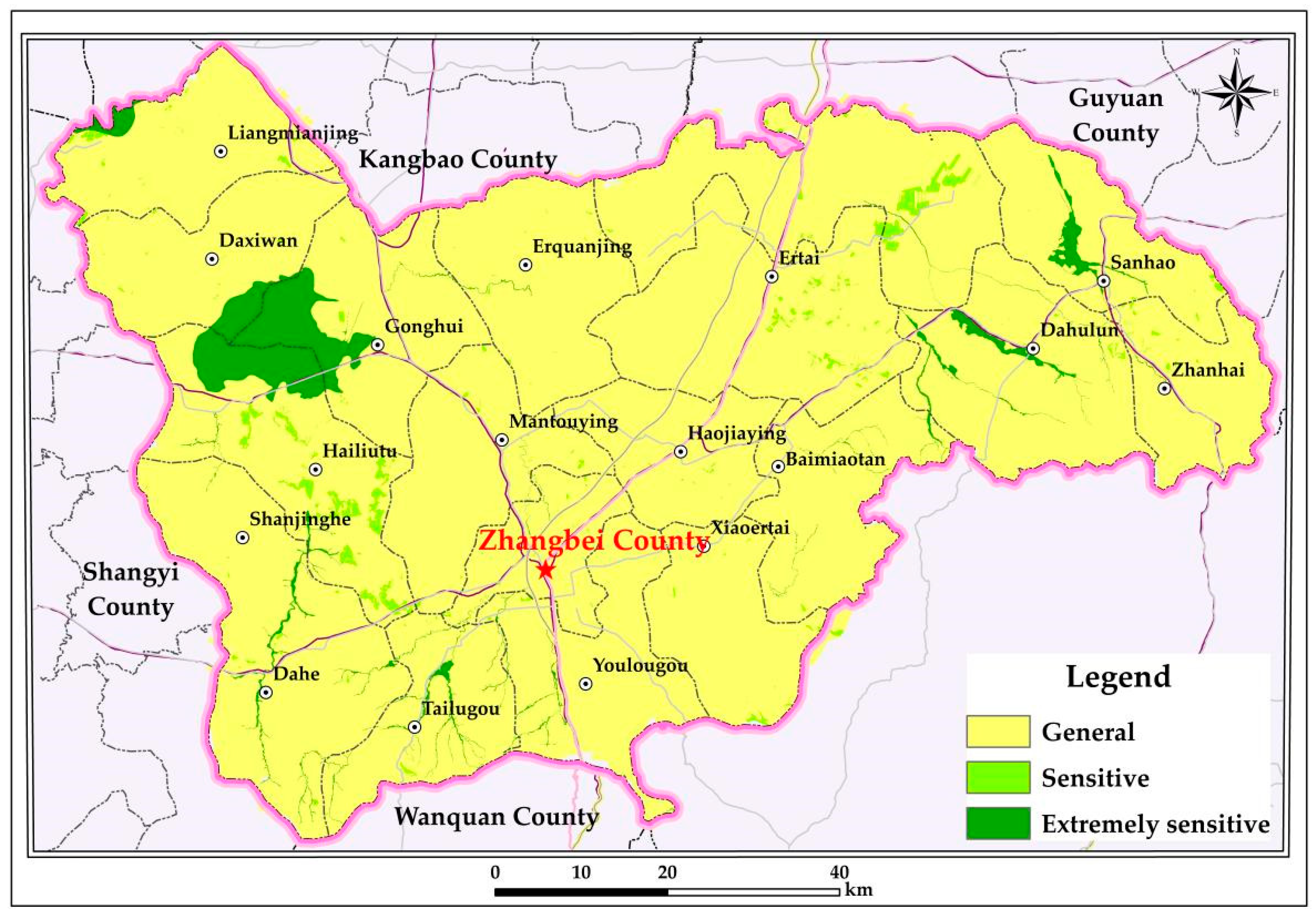
3.2. Evaluation Results of Ecological Sensitivity

Overall, the moderate ecological sensitivity is predominant in the study area (Figure 6, Table 5), covering 4063.34 km2 (over 94% of the total area). The highly sensitive zones account for 179.44 km2 (4.15%), concentrated in wetlands such as Anguli Nao, Hailiutu Lake, and Dayingtan Lake. The sensitive zones span 77.91 km2 (1.80%).

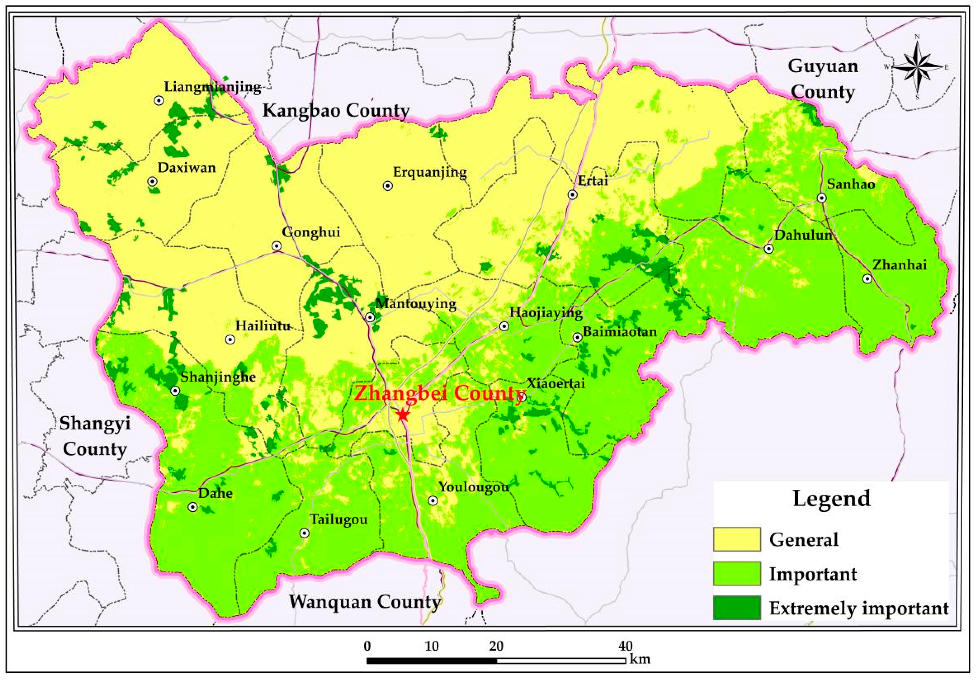
3.3. Evaluation Results of Ecological Protection Importance

For ecological conservation, the majority of Zhangbei is classified as the important zones (1943.86 km2; 44.99%) and the generally important zones (2043.79 km2; 47.30%). The extremely important zones of ecological protection cover only 333.04 km2 (7.71%), primarily clustered around wetlands, such as Angulinao, Hailiutu Lake, and Dayingtan Lake (Figure 7, Table 6).

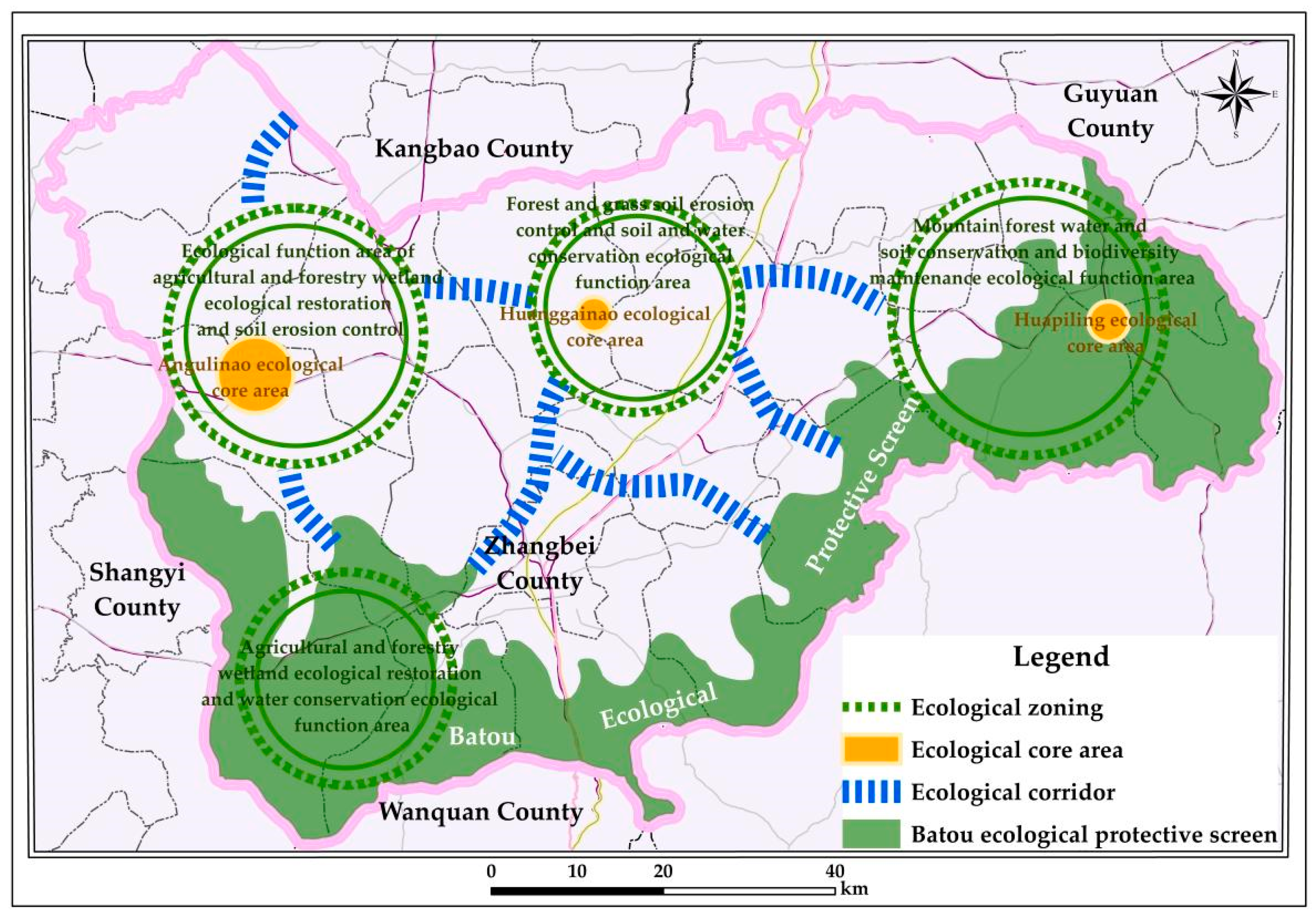
3.4. Results of Ecological Restoration Zoning

According to the evaluation results of the ecosystem service importance, ecological sensitivity importance, and ecological protection importance in Zhangbei and adhering to the aforementioned zoning and naming principles, the study area is divided into four ecological restoration zones (Figure 8) as follows:
  • Agro-forest–wetland ecological restoration and soil erosion control zone
This zone is dominated by forest and grassland, and is mainly located in northwestern Zhangbei, such as at Liangmianjing, Daxiwan, Gonghui, northwestern Hailiutu, and northern Mantouying. Anguli Nao Lake, in this zone, is one of the largest plateau lakes in northern China, but now it is severely deteriorating due to abrupt environmental change and overexploitation, which also exacerbates soil erosion. Thus, strategies including forest conservation and farmland-to-forest conversion are applied to rehabilitate degraded ecosystems, which helps the damaged ecosystem gradually recover.
  • Agro-forest–wetland ecological restoration and water conservation zone
This zone is dominated by farmland, forests, and wetlands, and mainly located in southwest Zhangbei, such as at Shanjinghe, Dahe, Tailugou, southern Hailiutu, southern Mantouying, and western Youlougou. Thus, strategies in this zone including rational agricultural resource allocation, site-specific afforestation to restore forest cover, and wetland rehabilitation in degraded areas are applied to enhance hydrological regulation and biodiversity.
  • Forest–grassland soil erosion and soil–water conservation zone
This zone is dominated by dense forests, and is mainly located in northern Zhangbei, such as at Erquanjing, Shagou, and northwestern Er’tai town. In this zone, intensive land use led to sparse vegetation, weak root systems, and severe soil erosion exacerbated by rainfall and human activities. Thus, strategies in this zone include establishing ecological shelterbelt systems, and strengthening vegetation protection and soil conservation are applied to curb erosion and boost ecosystem resilience.
  • Mountain forest conservation and biodiversity maintenance zone
This zone is dominated by dense forests, and is mainly located in southeastern Zhangbei, such as at Xiao’ertai, Baimiaotan, southeastern Er’tai town, southern Yuzhouying, Dahulun, Sanhao, and Zhanhai town. In this zone, it is covered by dense forests, diverse vegetation, and rugged terrain, which is critical for soil–water conservation and climate regulation. Thus, strategies in this zone, including banning deforestation and unregulated land clearing, and implementing graded forest protection, differentiated management, and compensation mechanisms are applied to stabilize soil retention and sustain forest ecosystem health.

4. Conclusions

This paper studied Zhangbei, Zhangjiakou in order to assess its importance of ecosystem function, ecological sensitivity function, and ecological conservation function, according to its current ecological conditions. Based on these evaluations, it was divided into targeted ecological restoration zones, and concludes the following:
  • The critically important zones of water conservation function are mainly distributed in southern Zhangbei and surround Huanggainao Lake in the north. The critically important zones of soil and water conservation function are mainly distributed in regions with abundant forest and grassland coverage. The critically important zones of water conservation function are mainly distributed in southern Zhangbei and surround the Huanggainao Lake in the north. The critically important zones of soil and water conservation are distributed in regions with abundant forest and grassland coverage. The critically important zones of biodiversity maintenance functions are mainly distributed around Xiaoertai Lake and its vicinity. The critically important zones of windbreak and sand fixation function are ubiquitously distributed throughout the country. The highly sensitive zones of ecological sensitivity, covering 4.15% of this area, are mainly distributed around wetland such as Anguli Nao. The important and generally important zones of ecological protection exhibit a distinct north–south spatial gradient. The critically important conservation zones with only 333.04 km2 (7.71%) predominantly overlap with wetland systems.
  • According to the evaluation of ecosystem service importance, ecological sensitivity importance, and ecological protection importance in Zhangbei, the study area is divided into four ecological restoration zones: agro-forest–wetland ecological restoration and soil erosion control zone, agro-forest–wetland ecological restoration and water conservation zone, forest–grassland soil erosion and soil–water conservation zone, and mountain forest conservation and biodiversity maintenance zone. Each zone was assigned tailored restoration measures, such as afforestation, wetland rehabilitation, and erosion control infrastructure, to address region-specific ecological challenges.
  • Compared to conventional approaches, this study prioritizes dominant ecological functions as the cornerstone of ecological restoration zoning in Zhangbei. By anchoring both the conceptual framework and practical implementation in these functions, the methodology clarifies pathways for integrated territorial space management and establishes a scientifically grounded basis for local ecological restoration and spatial governance.
  • Next, research will develop advanced multi-source data fusion to enhance DEM/NDVI spatiotemporal resolution, improve real-time vegetation/soil monitoring, conduct multi-scale evaluations and ecological simulations analyzing spatial heterogeneity impacts, and establish ecology–economy models to evaluate synergies between conservation and agricultural/energy development.

Author Contributions

Conceptualization, J.-J.M. and Y.-H.G.; methodology, Y.-H.G.; software, Y.-H.G. and D.-H.X.; validation, J.-J.M.; investigation, Y.-H.G., J.-J.M., X.-S.G. and W.W.; resources, J.-Q.Y.; data curation, Y.-H.G. and D.-H.X.; writing—original draft preparation, Y.-H.G.; writing—review and editing, J.-J.M., Y.Z. and H.-W.L.; visualization, Y.-H.G.; supervision, J.-J.M. and J.-Q.Y.; project administration, J.-Q.Y. and W.W.; funding acquisition, J.-J.M. All authors have read and agreed to the published version of the manuscript.

Funding

This research was funded by “the geological safety physical examination and risk assessment in Tianjin van (Grant no. DD20243452); the Monitoring and evaluation of resource and environment Carrying capacity of the Beijing-Tianjin-Hebei Collaborative Development Area and Xiongan New Area (Grant no. DD20221727).

Data Availability Statement

This study does not involve any patented technologies that have been applied for or are under review. All experimental data and methodologies were conducted in accordance with publicly available scientific research protocols.

Conflicts of Interest

The authors declare that they have no conflicts of interest.

References

  1. Fu, B.J. Trends and priority areas in ecosystem research of China. Geogr. Res. 2010, 29, 383–396. [Google Scholar]
  2. Lovell, S.T.; Taylor, J.R. Supplying urban ecosystem services through multifunctional green infrastructure in the United States. Landsc. Ecol. 2013, 28, 1447–1463. [Google Scholar] [CrossRef]
  3. Yang, S.; An, Y.; Wang, P.; Ma, L.; Hu, F.; Sun, Q. Study of ecological red-line zones in Guizhou Chishui River basin. Resour. Environ. Yangtze Basin 2015, 24, 1405–1411. [Google Scholar]
  4. Hou, P.; Yang, M.; Zhai, J.; Liu, X.; Wan, H.; Li, J.; Cai, M.; Liu, H. Discussion about natural reserve and construction of national ecological security pattern. Geogr. Res. 2017, 36, 420–428. [Google Scholar]
  5. Li, S.; Zhai, H. The comparison study on forestry ecological projects in the world. Acta Ecol. Sin. 2002, 22, 1976–1982. [Google Scholar]
  6. Ehrenfeld, J.G. Defining the limits of restoration: The need for realistic goals. Restor. Ecol. 2000, 8, 2–9. [Google Scholar] [CrossRef]
  7. Herbertson, A.J. The major natural regions: An essay in systematic geography. Geogr. J. 1905, 25, 300. [Google Scholar] [CrossRef]
  8. Palmer, M.A.; Bernhardt, E.S.; Allan, J.D.; Lake, P.S.; Alexander, G.; Brooks, S.; Carr, J.; Clayton, S.; Dahm, C.N.; Follstad Shah, J.; et al. Standards for ecologically successful river restoration. J. Appl. Ecol. 2005, 42, 208–217. [Google Scholar] [CrossRef]
  9. Mace, G.M. Whose conservation? Science 2014, 345, 1558–1560. [Google Scholar] [CrossRef]
  10. Geldmann, J.; Joppa, L.N.; Burgess, N.D. Mapping change in human pressure globally on land and within protected areas. Conserv. Biol. 2014, 28, 1604–1616. [Google Scholar] [CrossRef]
  11. Higgs, E.; Harris, J.; Murphy, S.; Bowers, K.; Hobbs, R.; Jenkins, W.; Kidwell, J.; Lopoukhine, N.; Sollereder, B.; Suding, K.; et al. On principles and standards in ecological restoration. Restor. Ecol. 2018, 26, 399–403. [Google Scholar] [CrossRef]
  12. Madrona Conservation Initiative. Prioritizing Aquatic Conservation and Restoration in the Pacific Northwest (Techniacal Report/EB/OL). 2022. Available online: https://www.madrona.org/reports/aquatic-conservation-pacific-2022 (accessed on 3 May 2025).
  13. Lathrop, R.B. Applying GIS and landscape ecological principles to evaluate land conseration alereratives. Landsc. Urban Plan. 1988, 41, 27–41. [Google Scholar] [CrossRef]
  14. Stoorvogel, J. Intergration of computer-based models and GIS tools to evaluate altermative land-use scenatries as part of an agricultural systems analysis. Agric. Syst. 1995, 49, 353–367. [Google Scholar] [CrossRef]
  15. Ayanu, Y.Z.; Conrad, C.; Nauss, T.; Wegmann, M.; Koellner, T. Quantifying and mapping ecosystem services supplies and demands: A review of remote sensing applications. Environ. Sci. Technol. 2012, 46, 8529–8541. [Google Scholar] [CrossRef] [PubMed]
  16. Wang, X.; Zhang, X.; Mu, X.; Zhu, Z. An analysis on the compilation method of ecological restoration planning for territorial space. Environ. Prot. 2019, 47, 36–38. [Google Scholar]
  17. Fang, C.; Wang, Z.; Liu, H. Exploration on the theoretical basis and evaluation plan of beautiful China construction. Acta Geogr. Sin. 2019, 74, 619–632. [Google Scholar]
  18. Wang, J.; Ying, L.; Zhong, L. Thinking for the transformation of land consolidation and ecological restoration in the new era. J. Nat. Resour. 2020, 35, 26–36. [Google Scholar]
  19. Yi, X.; Bai, C.; Liang, L.; Zhao, Z.; Song, W.; Zhang, Y. The evolution and frontier development of land ecological restoration research. J. Nat. Resour. 2020, 35, 37–52. [Google Scholar]
  20. Lv, J.X.; Li, Q. Research on the policy system and implement path of territorial ecological restoration. J. Hebei Acad. Sci. 2023, 40, 62–69. [Google Scholar]
  21. Liu, Y.; Shi, P.; Liu, M.; Xu, K.; Zhang, N.; Jiang, P.; Wang, W.; Jiang, Y. Spatial pattern of water conservation function and ecological management suggestion in the catchment area of the upper reaches of Qinhe River in the Yellow River Basin from 1990 to 2020. Geol. China 2024, 51, 1917–1929. [Google Scholar]
  22. Wang, C.; Hou, P.; Liu, X.; Yuan, J.; Zhou, Q.; Lv, N. Spatiotemporal changes in vegetation cover of the national key ecosystem protection and restoration project areas, China. Acta Ecol. Sin. 2023, 43, 8903–8916. [Google Scholar]
  23. Hua, Y.; Pan, J.; Du, J.; Li, Y.; Yang, Q.; Xu, S.; Huang, Y. Effects of the long-term ecological restoration in the eutrophic plateau shallow lake—A case study of Dabokou, Lake Dianchi. J. Lake Sci. 2023, 358, 1549–1561. [Google Scholar]
  24. Zhao, J.; Sa, N.; Fu, X.; Zheng, S.; Wu, G.; He, X.; Lu, Z.; Sang, W. Multi-scale coupling framework and method for mountains-rivers-forests-farmlands-lakes-grasslands ecological restoration projects: A case study of Shule River Basin. Acta Ecol. Sin. 2023, 43, 3841–3854. [Google Scholar]
  25. Liang, S.; Zhang, J.; Wang, K.; Liu, S. Methodology and application of carbon sink potential assessment for regional ecological conservation and restoration: Based on the research of the first batch of pilots for ecological protection and restoration project of mountains-rivers-forests-farmlands-lakes-grasslands system. Acta Ecol. Sin. 2023, 43, 3517–3531. [Google Scholar]
  26. Liu, Y.; Peng, J.; Li, G.; Han, W.; Liu, L.; Guan, J.; Ju, X.; Zheng, J. Eco-environmental assessment of Kurustai grassland based on Google Earth Engine. Chin. J. Ecol. 2023, 42, 2776–2785. [Google Scholar]
  27. Peng, Y.; Zhuang, X.; Zhao, L.; Wang, Z.; Gao, J.; Wang, B.; He, Z. Influence of species choice and tidal flat elevation on the carbon sequestration of early mangrove restoration. Acta Sci. Nat. Univ. Sunyatseni 2023, 62, 37–46. [Google Scholar]
  28. Cai, H.; Chen, Y.; Zha, D.; Zeng, H.; Shao, H.; Hong, T. Principle and method for ecological restoration zoning of territorial space based on the dominant function. Trans. Chin. Soc. Agric. Eng. Trans. CSAE 2020, 36, 261–270. [Google Scholar]
  29. Yu, J.; Dong, Y.; Tian, Y.; Hu, Z. Provincial comprehensive land use reorganization based on resource integration, Zhejiang. Planners 2021, 37, 17–23. [Google Scholar]
  30. Bai, S.; Wu, M.; Yu, Y. Identification of key ecological restoration areas and optimal allocation of vegetation for water conservation in Hanjiang River Basin. Bull. Soil Water Conserv. 2023, 43, 123–128. [Google Scholar]
  31. Kong, F.; Duan, S.; Xu, C. The construction of ecological security pattern based on ecosystem services and ecological sensitivity: A case study of the Qiantang River Basin. Acta Ecol. Sin. 2024, 44, 11359–11374. [Google Scholar]
  32. Dong, Q.; Liang, S.; Liu, B. Current situation and developing counter measures of ecological construction of agriculture and husbandry in Hebei Bashang. J. Anhui Agric. Sci. 2006, 34, 310–312. [Google Scholar]
  33. Fan, Y.; Hu, N.; Ding, S.; Liang, G.F.; Lu, X.L. Progress in terrestrial ecosystem services and biodiversity. Acta Ecol. Sin. 2016, 36, 4583–4593. [Google Scholar]
  34. Li, L.; Wu, D.; Liu, Y.; Teng, L.; Wu, Z.; Feng, Z. “Double evaluations” of karst area from the perspective of ecological civilization: A case study of Ningyuan in ecologically sensitive area. J. Nat. Resour. 2020, 35, 2385–2400. [Google Scholar] [CrossRef]
  35. Zhang, X.; Liang, H.; Hu, Y.; Wang, Z. Comprehensive evaluation and prevention and control zoning of ecological risk based on “ecological sensitivity and interference”. Geogr. Geo-Inf. Sci. 2020, 36, 112–118. [Google Scholar]
  36. Su, H.; Wang, F.; Chen, H.Y.; Liu, X.; Wei, Y.; Luo, Y.; Chen, L.; Bai, M. Planning and practice of ecological protection and restoration project of “mountain-river-forest-farmland-lake-grassland” in Lishui City, Zhejiang Province. J. Environ. Eng. Technol. 2022, 12, 224–231. [Google Scholar]
  37. Jiang, W.; Meng, L.; Liu, F.; Liu, H.; Zhang, J.; Ning, H. Research on exploitation, utilization and environmental quality of groundwater in Zhangjiakou area and suggestions on its utilization and protection. North China Geol. 2022, 45, 44–54. [Google Scholar]
  38. Wang, C.; Zhang, J.; Peng, B.; Wang, J.; Yu, J.; Wu, J. Research on the optimization of land spatial pattern based on “dual evaluation”: Taking Anyuan, Jiangxi province as an example. North China Geol. 2023, 46, 69–78. [Google Scholar]
  39. Yin, Z.; Zhao, L.; Liu, W.; Li, R.; Shao, H.; Peng, C.; Tian, Y. Shrinkage reasons and countermeasures of Moon Lake area in the eastern part of Bashang Plateau, Chengde City. Hydrogeol. Eng. Geol. 2020, 47, 57–64. [Google Scholar]
  40. Tucker, C.J. Red and photographic infrared linear combinations for monitoring vegetation. Remote Sens. Environ. 1979, 8, 127–150. [Google Scholar] [CrossRef]
  41. Peng, J.; Liu, Z.; Liu, Y.; Wu, J.; Han, Y. Trend analysis of vegetation dynamics in Qinghai Tibet Plateau using Hurst Exponent. Ecol. Indic. 2012, 14, 28–39. [Google Scholar] [CrossRef]
  42. Zhao, Z.; Liu, J.; Peng, J.; Li, S.; Wang, Y. Nonlinear features and complexity patterns of vegetation dynamics in the transition zone of North China. Ecol. Indic. 2015, 49, 237–246. [Google Scholar] [CrossRef]
  43. National Development and Reform Commission, Ministry of Environmental Protection. Guidelines for Drawing Red Lines for Ecological Protection; General Office of the Ministry of Environmental Protection: Beijing, China, 2017. [Google Scholar]
  44. Zhu, Z.; Wang, X.; Rao, S.; Zhang, X.; Li, C.; Li, C.; Li, D.; Mu, X. Study of the method on zoning of territorial space ecological protection and rehabilitation and case of Chengde. Environ. Ecol. 2020, 2, 1–7. [Google Scholar]
  45. Liu, J.; Ma, S.; Gao, J.; Zou, C.; Wang, J.; Liu, Z.; Wang, L. Delimiting the ecological conservation redline at regional scale: A case study of Beijing-Tianjin-Hebei region. China Environ. Sci. 2018, 38, 2652–2657. [Google Scholar]
  46. Li, J.; Wang, Y.; Yin, S.; Cui, L.; Deng, X. Evaluation of ecological conservation importance and regionalization of dominant ecological function in Zhangjiakou. Chin. J. Soil Sci. 2020, 51, 280–288. [Google Scholar]
Figure 1. The location of study area.
Water 17 01393 g001
Figure 2. Evaluation processes of water conservation function importance.
Water 17 01393 g002
Figure 3. Flowchart of the evaluation of the importance of ecological protection.
Water 17 01393 g003
Figure 4. Ecological service function importance in Zhangbei. (a) Evaluation of water conservation function importance; (b) evaluation of soil and water conservation function importance; (c) evaluation of biodiversity maintenance function importance; and (d) evaluation of windbreak and sand fixation function importance.
Water 17 01393 g004
Figure 5. Evaluation of ecosystem service function importance in Zhangbei.
Water 17 01393 g005
Figure 6. Evaluation of ecological sensitivity of Zhangbei.
Water 17 01393 g006
Figure 7. Evaluation of ecological protection importance in Zhangbei.
Water 17 01393 g007
Figure 8. Ecological restoration zoning map of Zhangbei.
Water 17 01393 g008
Table 1. Main data applied in this article.
DataDescriptionResolution Ratio/kmData Sources
Elevation data setDEM taster data0.03Geo-spatial data cloud
NDVI data setRaster1MOSIS
NPP data setRaster1GLASS dataset
Soil data setRaster1Geo-graphic remote sensing ecological network platform
Meteorological and climate data setsRaster/text1China meteorological science data
Table 2. Thresholds for soil and water conservation functions importance.
Slope GradientForest, Scrub and Grassland Coverage More Than 60%Forest, Scrub and Grassland Coverage Is 20–60%Forest, Scrub and Grassland Cover Less Than 20%
Steep531
Relatively steep331
Gradual111
Table 3. Evaluation results of ecological functions in Zhangbei.
FunctionExtremely ImportantImportantGenerally Important
Area
(km2)
Proportion (%)Area
(km2)
Proportion (%)Area
(km2)
Proportion (%)
Water conservation445.5310.311951.4545.171923.7144.52
Soil and water conservation302.867.012957.1268.441060.7124.55
Biodiversity maintenance495.7211.471004.9323.262820.0465.27
Windbreak and sand fixation1753.1340.582067.6747.85499.8911.57
Table 4. Evaluation of ecosystem service function importance in Zhangbei.
FunctionExtremely ImportantImportantGenerally Important
Area
(km2)
Proportion (%)Area
(km2)
Proportion (%)Area
(km2)
Proportion (%)
Ecosystem service function203.694.711970.7745.612146.2349.67
Table 5. Summary table of ecological sensitivity evaluation results of Zhangbei.
FunctionHighly SensitiveSensitiveModerate
Area
(km2)
Proportion (%)Area
(km2)
Proportion (%)Area
(km2)
Proportion (%)
Ecological sensitivity179.444.1577.911.804063.3494.04
Table 6. Evaluation of ecological protection importance in Zhangbei.
FunctionExtremely ImportantImportantGenerally Important
Area
(km2)
Proportion (%)Area
(km2)
Proportion (%)Area
(km2)
Proportion (%)
Ecological protection333.047.711943.8644.992043.7947.30
Disclaimer/Publisher’s Note: The statements, opinions and data contained in all publications are solely those of the individual author(s) and contributor(s) and not of MDPI and/or the editor(s). MDPI and/or the editor(s) disclaim responsibility for any injury to people or property resulting from any ideas, methods, instructions or products referred to in the content.

