Article

Groundwater Extraction Causes a Rapid Reduction in Spring Expression at Abercorn Springs in the Recharge Area of the Great Artesian Basin, Australia

Department of Local Government, Water and Volunteers, Bundaberg, QLD 4670, Australia
*
Author to whom correspondence should be addressed.
Water 2025, 17(9), 1338; https://doi.org/10.3390/w17091338
Submission received: 21 March 2025 / Revised: 15 April 2025 / Accepted: 23 April 2025 / Published: 29 April 2025
(This article belongs to the Section Water Resources Management, Policy and Governance)

Abstract

:
Groundwater levels were monitored before, during and after groundwater pumping to understand the impacts of groundwater extraction on Abercorn Spring, a recharge spring in the Great Artesian Basin (GAB) in southeast Queensland, Australia. We measured the wetted area of the spring during this time to understand if changes in hydrology affected the water available for vegetation communities. Sustained groundwater extraction >20 km upgradient of the spring resulted in (1) rapid drawdown of the source aquifer, causing a reduction in aquifer pressure; (2) a small decline (0.35 m) in water level at the spring; and (3) a significant change (p = 0.0001) in wetted area in winter. Recovery of water levels and wetted area of the mound spring took over three years after pumping ceased. Our study demonstrated that significant changes to the wetted area occurred with only a minimal drawdown at the springs. Abercorn Springs have a natural low variability in water level (<0.2 m), implying a stable and predictable biological community. This natural range is less than half the water level change that is currently considered for impact assessment in artesian springs in the Queensland section of the GAB, highlighting the need to incorporate updated information to inform future management of both recharge and discharge springs. In the case of Abercorn Springs, long-term monitoring and research have led to refinement of license conditions for groundwater extraction, thereby mitigating further impacts to the springs and demonstrating adaptive management.

1. Introduction

The Great Artesian Basin (GAB) is Australia’s largest freshwater resource and one of the largest fresh groundwater aquifer systems in the world [1]. Natural discharge from the GAB maintains a range of artesian springs [2] including mound springs, mud springs, boggomoss springs, spring pools and groundwater seeps—many of which are natural assets with high conservation value [3,4]. Spring wetlands support a diversity of flora including sedges, reeds, grasses, herbs and algae, and provide habitat for an abundance of fauna including an array of fish, birds and invertebrates [5]. They also have profound cultural significance for both First Nations people and surrounding communities [6,7,8].
The decline in aquifer pressure resulting from groundwater exploitation is a common issue throughout the world with many studies highlighting the significant impacts on natural spring ecosystems [9,10,11]. Water extraction through uncontrolled artesian bores in the GAB since the late nineteenth century has caused significant changes to artesian pressure, dewatering many natural springs [7]. Progressive improvements to aquifer pressure across Queensland have been made under current management through caping and piping of free-flowing bores [12]. Changes in aquifer pressure and subsequent impacts on springs are complex, involving various processes and interactions, and it is important to note that the scale of impact may vary between springs. Understanding the natural variability in spring water discharge is crucial as a preliminary step to discerning potential impacts linked to groundwater extraction and other potential threatening processes such as climate change. The potential effects of climate change on water availability through altered precipitation patterns, increased evapotranspiration, and more frequent droughts have potential to intensify changes in groundwater resources by disrupting recharge rates and increasing pressure on aquifer systems [13,14].
The Abercorn Spring Complex is a recharge spring located on a grazing property near the township of Abercorn in the North Burnett region, approximately 30 km south of Monto, Southeast Queensland, Australia. The complex is listed as an active palustrine spring wetland in the Queensland Springs database and belongs to the Springsure GAB Springs Supergroup [15]. The complex consists of four spring vents, one of which is a mound spring (hereafter referred to as the Abercorn Mound Spring). The Abercorn Mound Spring provides an important water supply and habitat for a wide range of native flora and fauna, including nine species of frogs, five lizards, three snakes, 19 mammals, 79 birds and 82 native plant species including 1 native grass species (Arthraxon hispidus) listed as ‘vulnerable’ under the Nature Conservation Act 1999 and the Environment Protection and Biodiversity Conservation Act 1999 [16]. The species richness of native plants and terrestrial vertebrates is considered high for such a small spatial area [16].
Abercorn Springs are within the Mulgildie Basin—a small, elongated section of the GAB approximately 100 km long (north–south) and 25 km wide (west–east) [17]. The most significant geological structure in the area is the Anyarro Fault [18]. The fault trends north–south and has a significant displacement (up to 300 m) resulting from mass movement of rock [18,19]. Site stratigraphy, surface geological mapping, ground surface elevations and water chemistry give indication that the main source aquifer supplying water to Abercorn Springs is the Precipice Sandstone, with the Anyarro Fault thus providing a clear potential vertical migration path from the Precipice Sandstone up to the surface [18,19,20].
In 2000, a water license was granted to a mining enterprise 21 km upgradient from Abercorn Springs to extract water from the Precipice Sandstone, and it was acknowledged at the time that there was potential for impacts from the drawdown of water on the springs as well as a local town water supply [21]. Simulation of drawdown at Abercorn Springs was modelled based on pump tests at the bore with an aquifer thickness of 43 m that resulted in estimated aquifer parameters (transmissivity of 80 m2, hydraulic conductivity of 3.60 m/day and storativity of 5.45 × 10⁻⁵) [21]. Drawdown simulation suggested that drawdown at the springs was possible after 90 days [21]. The resultant license conditions included requirements to measure the distance from marked locations to the wetted perimeter of the mound spring, monitor water levels in bores, and perform water quality sampling [22]. This license was granted based on the regulations in place at the time and before broader implementation of sustainable management of the GAB in 2007 with the first water plan that covered the whole of the GAB within Queensland- the Water Resource (Great Artesian) Plan 2006 [23]. More recently, the management of water within the Queensland section of the GAB became governed by the provisions of the Water Plan (Great Artesian Basin and Other Regional Aquifers) 2017 [24]. Under this plan, underground water is further managed and allocated in a way that seeks to achieve a sustainable balance between a number of outcomes, including the protection of the flow of water to groundwater-dependent ecosystems (GDEs) that support significant cultural and environmental values. Monitoring and reporting requirements for the plan include the requirement to monitor trends in the groundwater flow to GDEs by establishing a GDE monitoring network. Abercorn Springs is one of the recharge springs included in this network.
Monitoring approaches for detecting an impact at artesian springs have been a subject of discussion for many years. It has been suggested that monitoring water levels at springs to establish impact is a misguided strategy due to the lack of confidence that water levels can be measured with enough accuracy and in a timely manner before springs are deprived of adequate water [25]. Currell et al. [25] proposed an alternative strategy to manage impacts on springs involving the establishment of source aquifers, water level monitoring in source aquifers to understand baseline variability, monitoring fluxes at springs including predevelopment conditions, and finally a water balance analysis to assess the relationship between water levels and fluxes [25]. Furthermore, Harrington et al. [26] identified that there is a need to identify the biological objective of the GDE, the threshold that supports that objective, and then set triggers at monitoring locations upgradient from the GDE to maintain the objective including management actions to mitigate negative effects. Implementing a monitoring system for the capture of spring dynamics is imperative, as well as utilising real-time spring response data to address any adverse changes in the system. The use of real-time water level data in bores and the spring provides a basis to identify localised impacts including the effects of surface water inputs (rainfall and runoff) from broader-scale basin impacts. It also provides greater certainty in recharge rates and validates previous assumptions of impacts to downgradient flow identified through pumping studies [21].
The aims of this study were to (1) use real-time monitoring of water levels in both monitoring bores and the Abercorn Mound Spring to track changes in water levels caused by upgradient pumping; (2) measure the natural variability of water levels within the Abercorn Mound Spring; (3) use historical monitoring of wetted areas to test for significant pumping effects on the wetted area of the Abercorn Mound Spring; (4) assess whether the use of an impact trigger at Abercorn Springs, or monitoring bores as proposed by Currell et al. [25], is most appropriate to manage impact at the springs; and (5) describe management actions that have ascended from the monitoring to aid in the future protection of the springs.

2. Materials and Methods
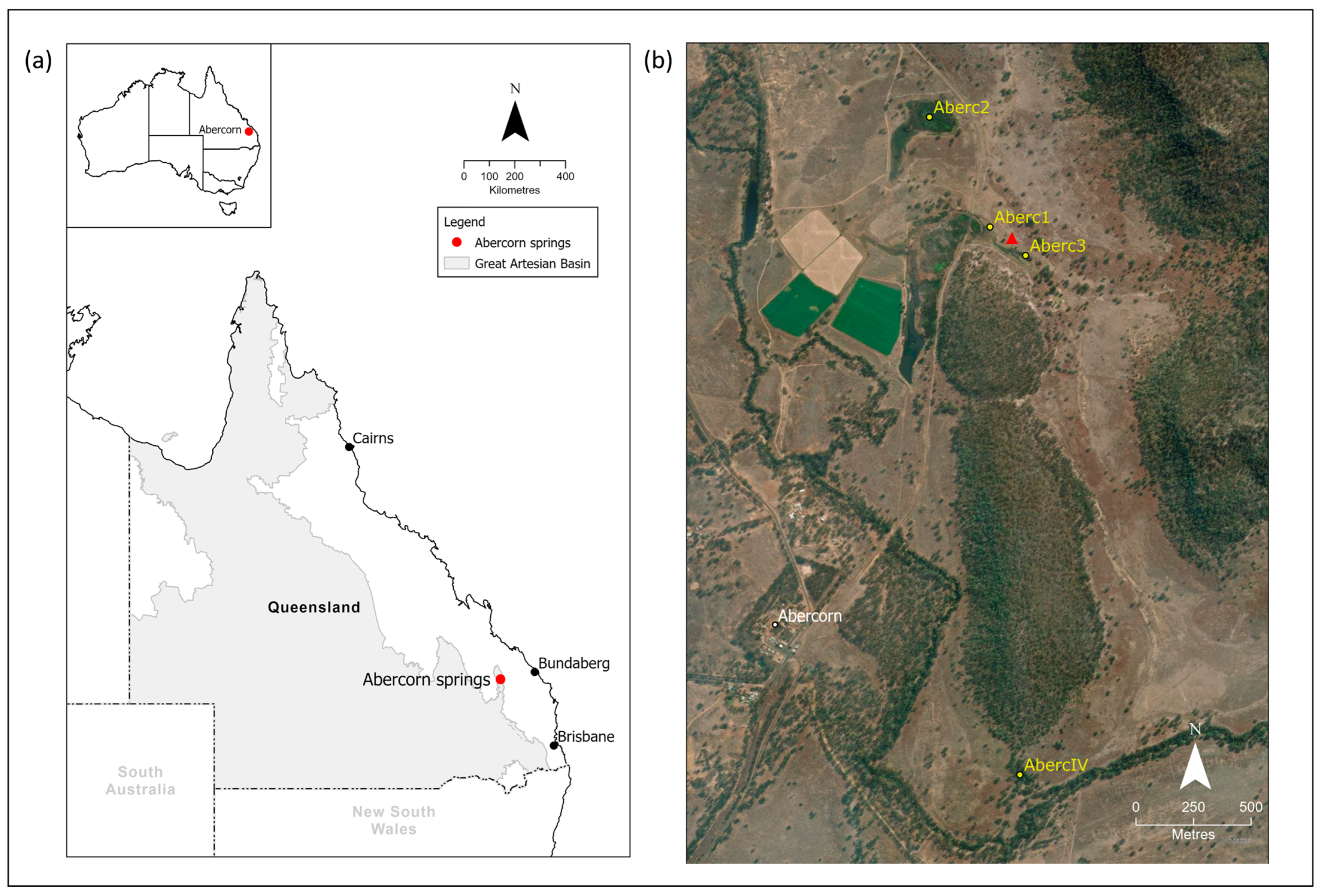
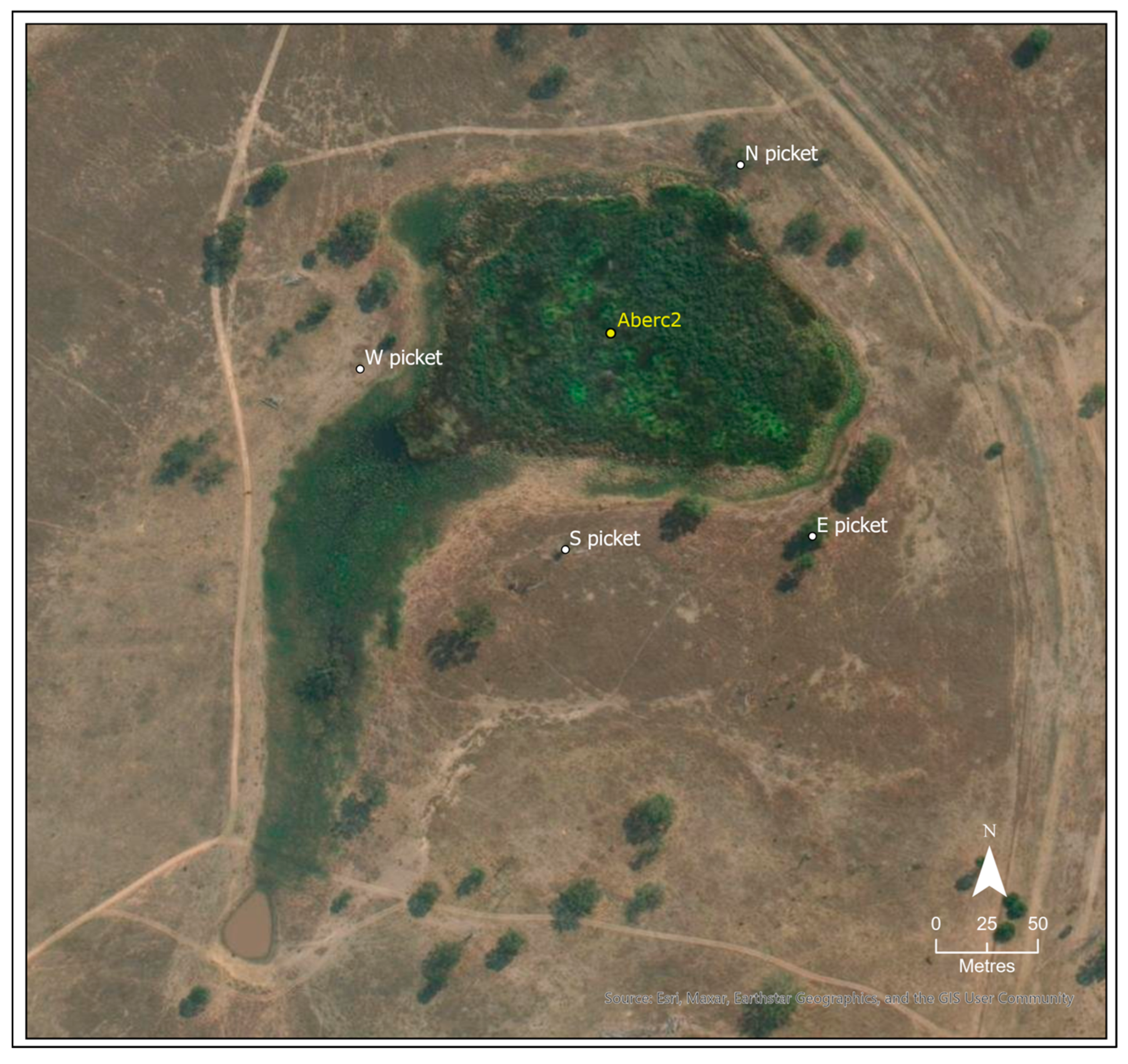
2.1. Spatial Area

Of the four known vents in the Abercorn Springs complex, the Abercorn Mound Spring (Site Aberc2, Figure 1b) is the largest and has the longest record of continuous monitoring since 2005. The spring is elevated in the local catchment and hence only has 45 hectares of land that would provide runoff during heavy rainfall. A well of unknown construction lies approximately 460 m southeast of the mound and is a historic water monitoring site that has been in existence for many decades (Figure 1b).

2.2. Water Level

Depth/temperature dataloggers (Diver, Van Essen Instruments, Delft, The Netherlands) were installed in the Abercorn Mound Spring, in two monitoring bores and the well. The loggers were programmed to collect data every hour, and were downloaded every three months. The logger at the Mound Spring was placed in a constructed piezometer at the highest elevated position. A corresponding barometric pressure datalogger was installed at the site, and this was used to compensate for the depth/temperature datalogger to allow for accurate measurements of water levels. The second logger was installed attached to a PVC pipe mounted inside the well. Note that the well has a horizontal PVC pipe that allows discharge at a certain water level and, as such, is not a true indication of pressure changes to the aquifer at the springs (the water level changes are dampened by both leakage around the well and the discharge from the pipe). The loggers installed in two sub-artesian monitoring bores intercepting the Precipice Sandstone were approximately 7.7 km and 14.8 km downgradient from the point of extraction. There is only one large production bore, and it is 21 km upgradient from the Abercorn Mound Spring. All loggers have been in place for more than 6 years. Rainfall data were obtained from the existing gauging station network within the catchment (Three Moon Creek at Abercorn—Site 136101C—1.7 km from the mound spring).

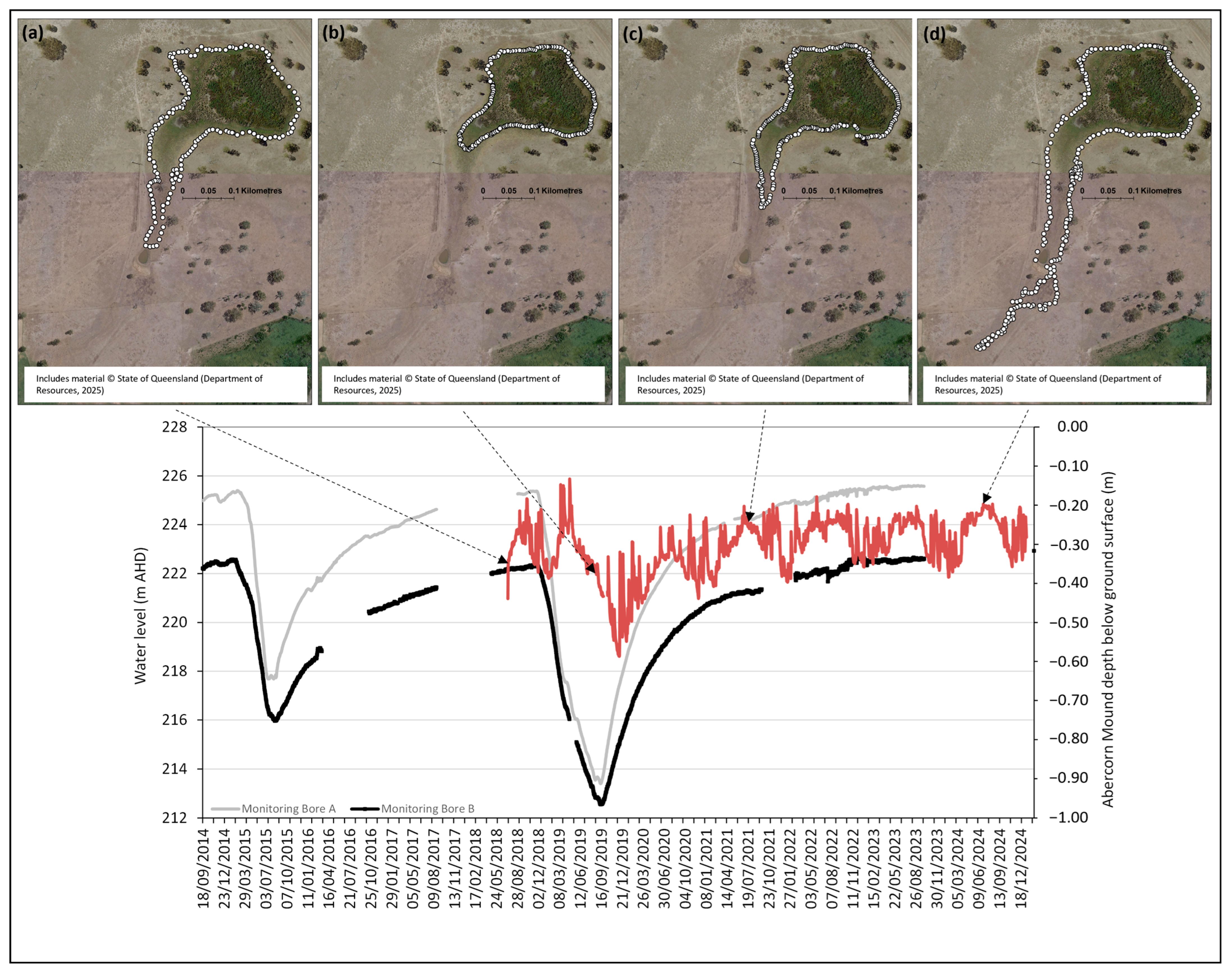
2.3. Wetted Area Extent
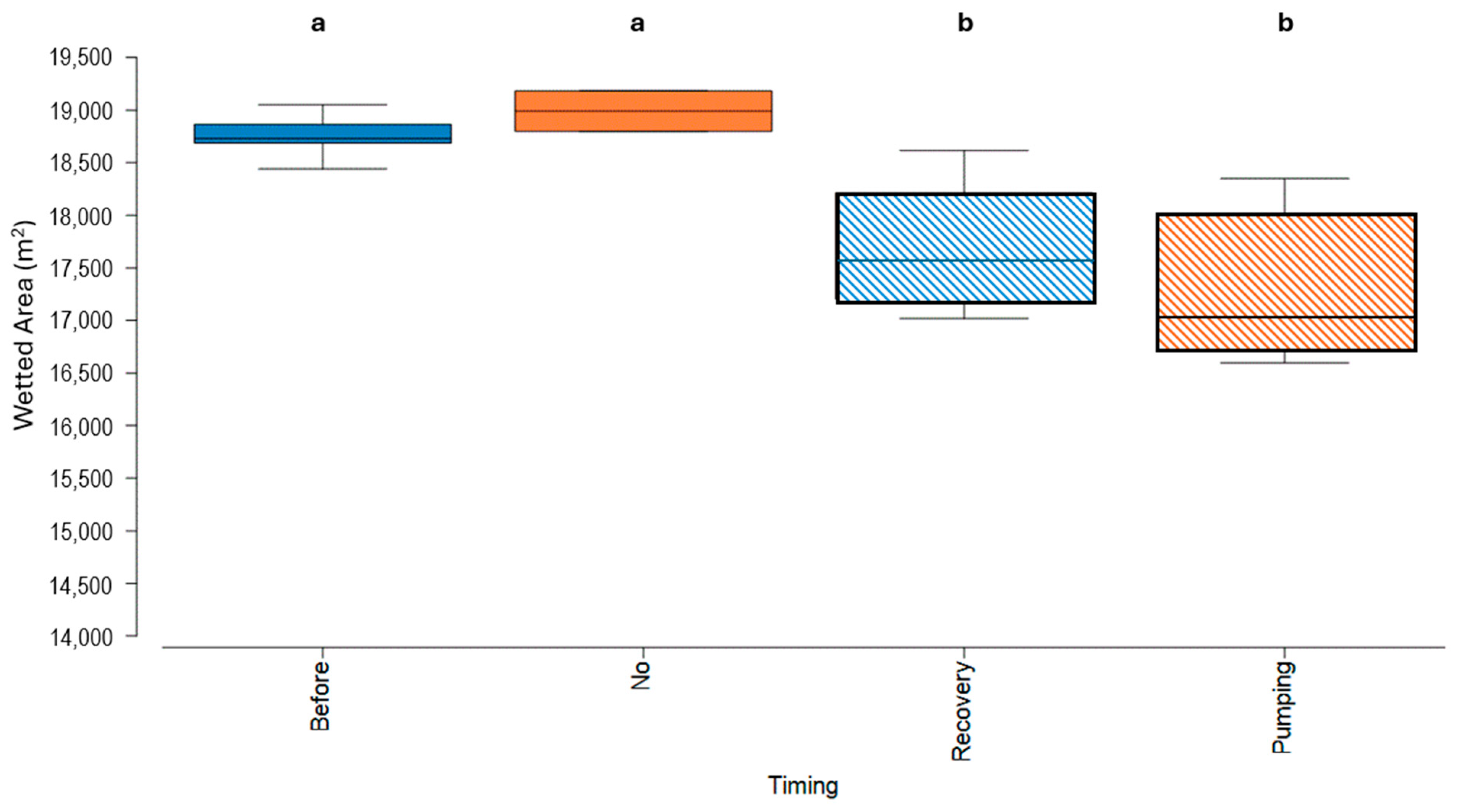
The wetted area extent at Abercorn Mound Spring was monitored between 2005 and 2025 using two different approaches. The first approach is based on methodology established by Fairfax and Fensham [27], which describes a relationship between spring flow and vegetated wetland area, with the principle that perennial wetland plants only grow where there is permanent water [28]. This method was modified to involve direct measurement of the wetted perimeter along six set bearings from four permanent markers that were placed around the spring in 2005 (Figure 2). The wetted perimeter is defined as the point where free water exists and where the soil contains free water when stepped upon. A polygon area was then produced based on straight lines between measurement points to measure changes in monthly area (units–m2). Measurements were collected monthly up until April 2007, after which time they were then collected only two times a year (winter: June–August; summer: December–February), with the exception of 2019–2020, where monthly sampling recommenced in June 2019 and ceased after February 2020 due to COVID-19 limitations on fieldwork. This recommencement of monthly sampling aligned with the commencement of pumping in 2019. Assessment of the monthly measurements showed that the most change to the wetted area typically occurred between the seasons, so biannual sampling in winter and summer was used to capture the seasonal variation as well as short-term impacts and recovery signals.
The effect of pumping on the winter wetted area calculated by a polygon was analysed through a Kruskal–Wallis test with post hoc testing using a Tukey–Kramer test due to unequal sample sizes and heterogenous variances [29]. The pumping effect was grouped by data collected before major pumping occurred in 2012 (Before); during pumping periods (Pumping); and after pumping had ceased and water levels were recovering (Recovered) and where no pumping had occurred for more than 3 years (No). The mean wetted areas and variability were plotted for each group in a box–whisker plot.
The second method involved walking the wetted perimeter with a handheld GPS. Once the GPS had established an appropriate level of satellite coverage with an accuracy of ±3 m, the wetted perimeter around the spring wetland was walked and waypoints marked at frequent distances. The wetted edge is determined as per Wormington and Black [16]. Using this approach, the wetted area extent was monitored monthly from June 2018 to March 2020, and biannually thereafter to align with the maximum and minimum periods previously identified.

3. Results

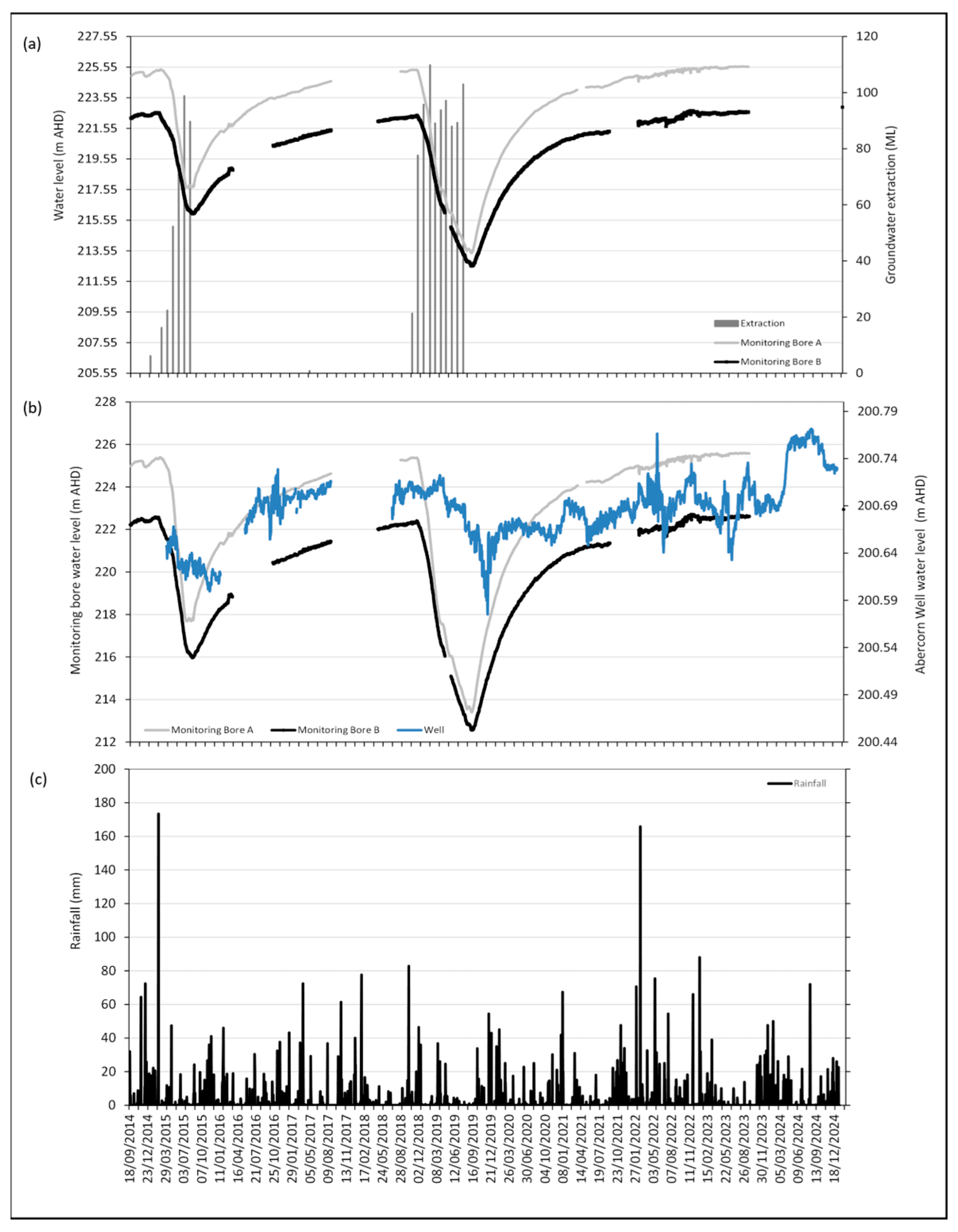
3.1. Impacts of Groundwater Pumping on Water Levels

Extraction of groundwater from the production bore 21 km north of Abercorn Mound Spring occurred from August 2007 to July 2008; May 2012 to June 2013; January 2015 to August 2015; May 2017; and November 2018 to August 2019.
Water levels in the upgradient monitoring bores located 7.7 km (Monitoring Bore 1) and 14.8 km (Monitoring Bore 2) downgradient from the point of extraction show a decline in water levels within 1–2 months following the commencement of pumping and slow, gradual recovery once pumping pressure ceases (Figure 3a). Recovery of water levels takes over three years. The water levels in the monitoring bores recede by as much as 10 m within 9 months from the commencement of pumping. The behaviour of the well near Abercorn Mound Spring (located 21 km from the point of extraction) shows a similar pattern in response to pumping; however, unlike the monitoring bores which showed a decline in water level within 1–2 months, the water level behaviour in the well exhibited a delayed response with the decline occurring 5 months after the commencement of pumping (Figure 3b). The water level in the well dropped by 140 mm after pumping in 2019 and was the lowest on record. Cumulative rainfall in early 2024 (Figure 3c), causing a recharge event, sustained raised water levels in both the well and the spring.
The water level at Abercorn Mound Spring also decreased in response to pumping activity; however, like the well, there was a 5-month lag in response to the commencement of pumping (Figure 4). Water levels dropped by ~0.35 m after pumping in 2019 and did not recover for three years. The reduction in groundwater pressure manifested in a reduced wetted area extent at the springs in the winter of 2019 when the water level had declined by <0.2 m. No spatial expansion of the wetland tail was observed during this winter (Figure 4b). The water level monitoring at the spring highlights the rapid and temporary water level rises due to local catchment rainfall and runoff, with levels stabilising back to antecedent levels within days.

3.2. Seasonal Variation Measured by Distance Measurements

Between 2005 and 2012, the winter wetted area of Abercorn Mound Spring was very consistent, with only slight variations (Figure 5). There was no substantial groundwater extraction from the source aquifer prior to 2005, and pumping only began in 2007, so this period highlights a relatively stable groundwater aquifer with minimum disturbance to the springs. The minimum wetted area occurs in the summer months, and measurements show that it is more variable during these months, reflecting localised rainfall conditions.
After more substantial groundwater extraction commenced in 2012, there were noticeable effects. Firstly, there were numerous instances both in summer and winter where at least one distance measurement from the marker point to the wetted area could not be measured because the spring at that marker point was dry. Thus, without a complete set of measurements, the polygon area could not be calculated. This did not occur prior to pumping in 2012. Secondly, the calculated wetted area from the winter measurements after 2012 was lower and more variable than the natural range prior to 2012 and only recovered in 2022 and 2024.
Statistical analysis of the effect of pumping on the wetted area of the Abercorn Mound Spring wetland revealed a significant effect of pumping (Tukey–Kramer test, p = 0.0001). The mean wetland area for the ‘Before’ and ‘No’ groups was similar (Figure 6, group a), as was the mean wetland area for the ‘Pumping’ and ‘Recovery’ groups (Figure 6, group b). There were significant differences between the mean wetland area for group a (‘Before’ and ‘No’ groups) and group b (‘Recovery’ and ‘Pumping’ groups).

4. Discussion

This study showed that groundwater extraction 21 km upgradient from Abercorn Springs had a rapid impact on downgradient water levels such that the source aquifer level dropped by ten metres within nine months. The groundwater pressure at the springs began to be impacted within five months of pumping commencement and showed measurable changes in water level both at the monitoring well and directly in the mound. Historical monitoring of the wetted perimeter of the mound spring by physical measurements from set points showed a seasonal pattern in the wetted area with a maximum in winter and generally a minimum in summer. This seasonal variation in wetted area is well documented in other spring wetlands [16,30]. The wetted area in winter was very consistent prior to groundwater pumping, but rapidly reduced outside these natural bounds and was found to be statistically significantly different, during and after pumping. The water pressure in the aquifer took over three years to recover following a 10-month pumping period, and this reflected the recovery time for the wetted perimeter of the mound.
Abercorn Mound Spring has markedly low natural variability in water level, typically within a range of less than 0.2 m. This inherent low variability in groundwater level is suggested to be an important factor supporting the unique biota found at springs, including ‘spring wetland’ vegetation dependent on permanent access to groundwater [31]. Fensham et al. [31] found that in most cases where spring wetland species were observed at Doongmabulla and Byarri Springs, the vegetation was either inundated or the water level was less than 0.2 m below the ground surface. Similar spring wetland vegetation species exist at Abercorn Mound Spring including hairy-joint grass (Arthraxon hispidus), which is listed as ‘Vulnerable’ under the Environment Protection and Biodiversity Conservation Act 1999. Populations of A. hispidus are found in niche locations throughout southern Queensland and New South Wales (Australia) [32]. White et al. [33] found that when water levels were reduced from waterlogged to well-drained for A. hispidus, there was a significant drop in plant vigour. Unnatural drying of semi-permanent inundated habitats is listed as a threatening process for this species, as the drying reduces the species vigour and overall cover and allows the establishment of introduced species [34].
Discharge springs within the GAB may be many hundreds of kilometres away from recharge areas of the source aquifer, and hence, impacts on aquifer pressure at the spring may take decades or longer to take effect [9]. The effect of capping and piping of previously flowing bores within Queensland that have been largely implemented within the last 20 years has been responsible for increased pressure in source aquifers and therefore the expansion of springs in recent years [9]. In contrast, our study has highlighted that aquifer pressure in this GAB recharge area is highly reactive and can rapidly decline (within months) and show recovery within three to four years. This highlights that environmental values of recharge springs may be at a greater risk from water level loss due to persistent groundwater extraction because of the proximity of the spring to the recharge area and the extraction point/s.
In support of Currell et al. [25], this study has demonstrated that a significant impact on spring discharge can begin to take place with only a minimal change in water level at the spring complex. The results from this study have shown that a drawdown of <0.2 m at the mound spring and nearby monitoring well resulted in a significant reduction in the wetted area of the spring. This observation is relevant to other springs likely to be affected by groundwater drawdown, particularly when impact threshold trigger values are set at or above 0.2 m. However, it is worth noting that other springs may exhibit different thresholds or responses depending on geology, vegetation, or distance to the extraction point. To effectively manage aquifers and safeguard artesian springs, it has been recommended that trigger levels in monitoring bores are used to maintain flow rather than a trigger at the point of impact [25,26,35,36]. This strategy aims to preserve natural flows by establishing early warning triggers at upgradient monitoring bores rather than relying on triggers at the actual point of impact, the difference being that by utilising upgradient monitoring bores with triggers, management is proactive in maintaining downgradient flow to the spring. Conversely, using triggers at the spring (point of impact) relies on the premise that the start of the impact can be measured, and furthermore, may require an impact to occur before management reacts (reactive management). Requiring upgradient monitoring bores for protection of all GAB springs is however impractical considering that there are approximately 304 spring complexes across the whole of the GAB [10]. Existing approaches such as using numerical impact assessment based on numerical equations of drawdown at locations are appropriate at scale, but must evolve with information on trigger levels and source aquifer understanding based on updated scientific information.
This study highlights the importance of long-term monitoring data to identify natural seasonal variability in water levels and wetted area extent. In this assessment, the data have been used to document the response of water levels in the Precipice Sandstone aquifer of the GAB and the wetted area of Abercorn Mound Spring to upgradient groundwater extraction. The result of these findings is that additional conditions on the water extraction license have been applied as part of an adaptive management approach. These conditions include a requirement for the license holder to install further monitoring equipment (i.e., a water level sensor and telemetry in the monitoring bore) and apply water level trigger thresholds that aim to stop and recommence groundwater pumping to maintain water levels within the natural range of the spring [22]. The implications of this research are that the protection of the spring wetlands within the complex will be achieved in accordance with the objectives of the GABORA Water Plan, and this is an example of an approach applicable to the protection of artesian springs at broader scales.
Through adequate research and monitoring at Abercorn Springs, many of the requirements that have been recommended by previous researchers for implementing an effective management strategy have been met, including (1) understanding source aquifers; (2) baseline monitoring of upgradient bores and spring wetted areas; (3) clarity on biological objectives; and (4) application of trigger levels and management actions to protect the springs [25,26]. The outcome serves as a successful instance of adaptive management.
This study has suggested that the reactiveness of recharge springs is potentially somewhat different to discharge springs. Therefore, management of groundwater extraction for recharge springs may need to be considered differently to discharge springs given that impacts on recharge springs may occur within months rather than years or decades as may occur for discharge springs [9]. Finally, given the naturally low variability in water level in the mound spring, attributable to seasonal evapotranspiration and the aquifer’s stable pressure, there is a need to refine the threshold-based approach currently employed in groundwater development decision-making. For example, up to 0.4 m of drawdown is allowed for water management decisions in the Water Plan (Great Artesian Basin and Other Regional Aquifers) 2017 [24]. This drawdown is at least double the level that caused significant reductions in the wetted area at Abercorn Mound Spring and if applied at Abercorn would cause water levels in the spring to drop below the accepted range utilised by spring wetland vegetation [31].
Although the discharge at Abercorn Mound Spring reduced during periods of extraction, this study has shown that aquifer water levels recovered, and the pressure was restored within three to four years after the cessation of pumping. Hence, the impact could be considered a short-lived ‘pulse disturbance’. Permanent changes to the floral taxa at the spring will most likely be driven by a ‘press disturbance’ [37]. This could take the form of a continued state of change in soil moisture on the fringe area of the mound, i.e., from either being permanently moist to intermittently moist, or from being intermittently moist to permanently dry. Had pumping pressure continued, the short-lived pulse disturbance may have changed into a long-lived press disturbance, potentially permanently altering the biota at the springs. Long-term monitoring of water levels and wetted area extent at Abercorn Mound Spring not only improved our understanding of the ecosystem’s response to disturbance but also provided valuable insights into the resilience of the wetland, which led to the development of a strategy (water level trigger thresholds) to manage and mitigate the impacts of disturbance. Implementing effective management strategies through an adaptive management framework aims to prevent ‘pulse disturbances’ transitioning into a ‘press disturbance’ with the intent to prevent irreversible ecological change. Adaptive management can only effectively react to disturbances by being provided with science that studies understanding exposure analysis (e.g., water level fluctuations) coupled with effect analysis (e.g., plant response, spatial distribution, persistence) to understand risk [38]. Only by understanding species water requirements (timing and duration of water provisions as well as ecological response) can adaptive management limit the risk of extinction of spring species by implementing management arrangements such as upgradient trigger levels in bores to stop a pulse disturbance turning into a press disturbance. Adaptive management can consider the intended outcome when setting management arrangements, with a gradient of management responses based on the value of the ecosystem for ecologically or culturally significant sites. Sites of higher value may warrant increased monitoring or stricter restrictions on allowed activities that could impact aquifer levels and consequently, the spring system that is valued.

5. Conclusions

In conclusion, this study has highlighted the importance of long-term monitoring data to identify natural seasonal variability in water levels and wetted area extent at Abercorn Mound Spring. This understanding has allowed for the assessment of impacts on the natural variability caused by groundwater extraction. Specifically, the main findings were as follows: (1) Groundwater extraction from the source aquifer resulted in a rapid decline in source aquifer water level and a significant change (p = 0.0001) in the winter wetted area at the springs within 5 months of pumping commencing. (2) A slow, gradual recovery occurred once pumping ceased and required greater than 3 years for water levels and winter spring wetted area to recover. (3) Changes to the wetted area affect the natural wetting and drying cycle, which has potential to alter the flora composition at the springs over time, including endemic threatened annual native grass species (Arthraxon hispidus) that require at least seasonal waterlogged conditions. (4) The use of upgradient monitoring bores for springs of high conservation or cultural value may be appropriate in certain circumstances to give greater confidence in the management of aquifer water levels through trigger levels rather than at the springs themselves. (5) The monitoring has resulted in new license conditions for the groundwater extraction bore examined in this study that include trigger levels on upgradient monitoring bores to limit future impacts on Abercorn Springs.

Author Contributions

Conceptualisation, S.M. and A.M.; methodology, S.M. and A.M.; formal analysis, S.M. and A.M.; investigation, S.M. and A.M.; resources, S.M. and A.M.; data curation, S.M.; writing—original draft preparation, S.M.; writing—review and editing, S.M. and A.M.; visualisation, S.M. and A.M.; project administration, S.M.; funding acquisition, A.M. All authors have read and agreed to the published version of the manuscript.

Funding

This research received no external funding.

Data Availability Statement

Data are contained within the article.

Acknowledgments

To the landholder, for allowing access to the site and providing historical information. To Tom Espinoza and Sally Obst for assistance in data collection in the field. To Coby Pymble-Ward and Peter Negus for editorial review.

Conflicts of Interest

The authors declare no conflicts of interest.

Abbreviations

The following abbreviations are used in this manuscript:
GABGreat Artesian Basin
GDEGroundwater-dependent ecosystem

References

  1. Smerdon, B.D.; Ransley, T.R.; Radke, B.M.; Kellett, J.R. Water Resource Assessment for the Great Artesian Basin. A Report to the Australian Government from the CSIRO Great Artesian Basin Water Resource Assessment; CSIRO Water for a Healthy Country Flagship; CSIRO: Canberra, Australia, 2012; 45p. [Google Scholar] [CrossRef]
  2. Habermehl, M.A. Springs in the Great Artesian Basin, Australia: Their Origin and Nature; Australian Government Publishing Service for the Bureau of Mineral Resources, Geology and Geophysics: Canberra, Australia, 1982; 50p. [Google Scholar]
  3. Noble, J.; Habermehl, M.; James, C.; Landsberg, J.; Langston, A.; Morton, S. Biodiversity implications of water management in the Great Artesian Basin. Rangel. J. 1998, 20, 275–300. [Google Scholar] [CrossRef]
  4. Fensham, R.J.; Fairfax, R.J. Spring wetlands of the Great Artesian Basin, Queensland, Australia. Wetl. Ecol. Manag. 2003, 11, 343–362. [Google Scholar] [CrossRef]
  5. Cantonati, M.; Fensham, R.J.; Stevens, L.E.; Gerecke, R.; Glazier, D.S.; Goldscheider, N.; Knight, R.L.; Richardson, J.S.; Springer, A.E.; Tockner, K. Urgent Plea for Global Protection of Springs. Conserv. Biol. 2021, 35, 378–382. [Google Scholar] [CrossRef] [PubMed]
  6. Hercus, L.; Sutton, P. The Assessment of Aboriginal Cultural Significance of Mound Springs in South Australia; Prepared in association with Kinhill Stearns; South Australian Department of Environment and Planning: Adelaide, Australia, 1985. [Google Scholar]
  7. Fairfax, R.J.; Fensham, R.J. In the Footsteps of J. Alfred Griffiths: A Cataclysmic History of Great Artesian Basin Springs in Queensland, Australia. Aust. Geogr. Stud. 2002, 40, 210–230. [Google Scholar] [CrossRef]
  8. Moggridge, B.J. Aboriginal People and Groundwater. Proc. R. Soc. Qld. 2020, 126, 11–27. [Google Scholar] [CrossRef]
  9. Fensham, R.J.; Laffineur, B. Response of Spring Wetlands to Restored Aquifer Pressure in the Great Artesian Basin, Australia. J. Hydrol. 2022, 612, 1–8. [Google Scholar] [CrossRef]
  10. Fensham, R.J.; Silcock, J.L.; Powell, O.; Habermehl, M.A. In Search of Lost Springs: A Protocol for Locating Active and Inactive Springs. Groundwater 2016, 54, 374–383. [Google Scholar] [CrossRef] [PubMed]
  11. Powell, O.; Fensham, R. The History and Fate of the Nubian Sandstone Aquifer Springs in the Oasis Depressions of the Western Desert, Egypt. Hydrogeol. J. 2016, 24, 395–406. [Google Scholar] [CrossRef]
  12. WatSec Environmental. Great Artesian Basin Basin-wide Condition Report 2024; Department of Climate Change, Energy, The Environment and Water: Canberra, Australia, 2024; 61p. Available online: https://www.dcceew.gov.au/sites/default/files/documents/gab-basin-wide-condition-report.pdf (accessed on 14 April 2025).
  13. Green, T.R.; Taniguchi, M.; Kooi, H.; Gurdak, J.J.; Allen, D.M.; Hiscock, K.M.; Treidel, H.; Aureli, A. Beneath the surface of global change: Impacts of climate change on groundwater. J. Hydrol. 2011, 405, 532–560. [Google Scholar] [CrossRef]
  14. Do, S.K.; Akhtar, F.; Goffin, B.; Aryal, A.; Tran, T.-N.-D.; Lipscomb, M.; Lakshmi, V. Assessing terrestrial water storage variations in Afghanistan using GRACE and FLDAS-Central Asia data. J. Hydrol. Reg. Stud. 2024, 55, 1–20. [Google Scholar] [CrossRef]
  15. DES. Queensland Spring Database. Department of Environment and Science. Queensland Government. 2018. Available online: https://www.data.qld.gov.au/dataset/2855849b-58f4-46f4-b0fb-4e74e86ce928/resource/4cdc89ef-b583-446e-a5c7-0836a91a3767/download/springsopd.zip (accessed on 6 March 2025).
  16. Wormington, K.; Black, R. Flora, Fauna and Freshwater Aquatic Study of the Abercorn Mound Springs Near Monto, North Burnett; Centre for Environmental Management, Central Queensland University: Rockhampton, Australia, 2009. [Google Scholar]
  17. Queensland. Department of Natural Resources and Mines. Hydrogeological Framework Report for the Great Artesian Basin Water Resource Plan Area; Department of Natural Resources and Mines: Brisbane, QLD, Australia, 2005; 151p, Available online: https://qldgov.softlinkhosting.com.au:443/liberty/OpacLogin?mode=BASIC&openDetail=true&corporation=DERM&action=search&queryTerm=uuid%3D%2244392224ac13040701ed88e94d1a245e%22&editionUuid=44392224ac13040701ed88e94d1a245e&operator=OR&url=%2Fopac%2Fsearch.do (accessed on 6 March 2025).
  18. EHA Pty Ltd. Identification of Source Aquifers to Significant Springs Dependent on Groundwater Flow from the Great Artesian Basin–Volume 2 Supporting Text and Annex of Appendices; Environmental Hydrology Associates: Tampa, FL, USA, 2009; 480p. [Google Scholar]
  19. Whitaker, W.G.; Murphy, P.R.; Rollason, R.G. Mundubbera 1:250,000 Geological Sheet SG56-5, Second Edition 1980. Available online: https://geoscience.data.qld.gov.au/data/dataset/cr040471/resource/geo-doc1171848-cr040471 (accessed on 6 March 2025).
  20. Whitaker, W.G.; Murphy, P.R.; Rollason, R.G.; Kirkegaard, A.G.; Von Gnielinski, F.E.; Withnall, I.W.; Lam, J.S.; Hebbard, C.L. Eidsvold Sheet 1:100,000 First Edition 2007. Available online: https://geoscience.data.qld.gov.au/dataset/mr000057 (accessed on 6 March 2025).
  21. AGE. Report on the Goondicum Water Supply Bore: Review of Groundwater Data; Bellridge Enterprises Pty Ltd., Australasian Groundwater & Environmental Consultants Pty Ltd.: Brisbane, Australia, 2013; 22p. [Google Scholar]
  22. McDougall, A.J. Abercorn Springs: Review of Historical Water Licence Condition Monitoring; Department of Regional Development, Manufacturing and Water: Brisbane, Australia, 2021; Available online: https://qldgov.softlinkhosting.com.au:443/liberty/OpacLogin?mode=BASIC&openDetail=true&corporation=DERM&action=search&queryTerm=uuid%3D%22b12f2e790a0200f00bf408d9000d9005%22&editionUuid=b12f2e790a0200f00bf408d9000d9005&operator=OR&url=%2Fopac%2Fsearch.do (accessed on 6 March 2025).
  23. Queensland Government. Water Resource (Great Artesian Basin) Plan 2006. Subordinate Legislation 2006 No. 49. Available online: https://www.legislation.qld.gov.au/view/pdf/asmade/sl-2006-0049 (accessed on 20 March 2025).
  24. Queensland Government. Water Plan (Great Artesian Basin and Other Regional Aquifers) 2017. Current as at 2 September 2017. Available online: https://www.legislation.qld.gov.au/view/pdf/inforce/current/sl-2017-0164 (accessed on 20 March 2025).
  25. Currell, M.J. Drawdown “Triggers”: A Misguided Strategy for Protecting Groundwater-Fed Streams and Springs. Groundwater 2016, 54, 619–622. [Google Scholar] [CrossRef]
  26. Harrington, R.; Rainville, K.; Blandford, T.N. Comment on “Drawdown ‘Triggers’: A Misguided Strategy for Protecting Groundwater-Fed Streams and Springs,” by Matthew J. Currell, 2016, v. 54, No. 5: 619–622. Groundwater 2017, 55, 152–153. [Google Scholar] [CrossRef] [PubMed]
  27. Fensham, R.J.; Fairfax, R.J. Development and Trial of a Spring Wetland Monitoring Methodology in the Great Artesian Basin, Queensland; Department of Environment and Resource Management: Brisbane, Australia, 2009; 38p. [Google Scholar]
  28. Williams, A.F.; Holmes, J.W. A Novel Method of Estimating the Discharge of Water from Mound Springs of the Great Artesian Basin, Central Australia. J. Hydrol. 1978, 38, 263–272. [Google Scholar] [CrossRef]
  29. Zar, J.H. Biostatistical Analysis, 2nd ed.; Prentice-Hall Inc.: Englewood Cliffs, NJ, USA, 1984; 718p. [Google Scholar]
  30. Blessing, J.; Negus, P.; Clifford, S. Springs Monitoring 2011: Great Artesian Basin Resource Operations Plan; Department of Science, Information Technology and Innovation: Brisbane, QLD, Australia, 2015; Available online: https://qldgov.softlinkhosting.com.au:443/liberty/OpacLogin?mode=BASIC&openDetail=true&corporation=DERM&action=search&queryTerm=uuid%3D%229a0dc2ecc0a862fe348a03d900023040%22&editionUuid=9a0dc2ecc0a862fe348a03d900023040&operator=OR&url=%2Fopac%2Fsearch.do (accessed on 6 March 2025).
  31. Fensham, R.J.; Laffineur, B.; Shand, P. Plant Species Associations with Alkaline Environments Associated with Artesian Spring Wetlands. Plant Soil 2021, 464, 199–208. [Google Scholar] [CrossRef]
  32. Queensland Government. Species Profile—Arthraxon hispidus. Available online: https://apps.des.qld.gov.au/species-search/details/?id=9964 (accessed on 20 March 2025).
  33. White, L.; Catterall, C.; Wirf, B.; Taffs, K. Waterlogging Tolerance of the Threatened Grass Arthraxon hispidus and Implications for Its Habitat Niche within Endangered Wetlands in North-Eastern New South Wales. Pac. Conserv. Biol. 2021, 27, 93–99. [Google Scholar] [CrossRef]
  34. White, L.; Catterall, C.; Taffs, K. The Effect of Disturbance and Drought on Hairy Jointgrass (Arthraxon hispidus) in North Coast New South Wales: Understanding Threatened Species Populations in a Dynamic Landscape. Austral Ecol. 2021, 46, 588–602. [Google Scholar] [CrossRef]
  35. Werner, A.D.; Alcoe, D.W.; Ordens, C.M.; Hutson, J.L.; Ward, J.D.; Simmons, C.T. Current Practice and Future Challenges in Coastal Aquifer Management: Flux-Based and Trigger-Level Approaches with Application to an Australian Case Study. Water Resour. Manag. 2011, 25, 1831–1853. [Google Scholar] [CrossRef]
  36. Currell, M.J. Reply to Harrington et al.’s Comment on “Drawdown ‘Triggers’: A Misguided Strategy for Protecting Groundwater-Fed Streams and Springs,” by Matthew J. Currell, 2016, v. 54, No. 5: 619–622. Groundwater 2017, 55, 154. [Google Scholar] [CrossRef] [PubMed]
  37. Underwood, A.J. Importance of Experimental Design in Detecting and Measuring Stresses in Marine Populations. J. Aquat. Ecosyst. Stress Recover. 2000, 7, 3–24. [Google Scholar] [CrossRef]
  38. McGregor, G.B.; Marshall, J.C.; Lobegeiger, J.S.; Holloway, D.; Menke, N.; Coysh, J. A risk-based ecohydrological approach to assessing environmental flow regimes. Environ. Manag. 2017, 61, 358–374. [Google Scholar] [CrossRef] [PubMed]
Figure 1. (a) Map showing the location of Abercorn Springs within the GAB and (b) the spatial arrangement of the four spring vents and location of Abercorn Well (red triangle).
Water 17 01338 g001
Figure 2. Map of Abercorn Mound Spring and the location of the four measurement points.
Water 17 01338 g002
Figure 3. (a) Source aquifer water level in response to pumping activity (water use data supplied by licensee), (b) water level behaviour in Abercorn Well (2014–2024), and (c) rainfall (mm).
Water 17 01338 g003
Figure 4. Groundwater level behaviour at Abercorn Mound Spring (red) in relation to upgradient monitoring bore levels. Graphic insets show the wetted area extent at Abercorn Mound Spring at corresponding water levels during (a) winter 2018, a period of groundwater pressure recovery following cessation of pumping in mid-2015; (b) winter 2019, a period of groundwater extraction; (c) winter 2021, a period of groundwater pressure recovery following cessation of pumping; and (d) winter 2024, groundwater pressure restored.
Water 17 01338 g004
Figure 5. Seasonal variations in wetted area extent at Abercorn Mound Spring before, during and after groundwater extraction. Groundwater extraction (shaded grey); spring wetted extent in winter (blue dots) and summer (brown dots); normal winter seasonal trend shown by black dashed line. Datapoints along x axis denote time periods where at least one measurement point was dry and so area could not be calculated.
Water 17 01338 g005
Figure 6. Box–whisker plot of the wetted area during winter grouped by the timing of pumping effects. ‘Before’ = wetted areas calculated before 2012 and prior to substantial pumping (n = 21); ‘Pumping’ = wetted areas calculated during pumping periods and including 5 months after pumping cessation to incorporate lag effects of pumping (n = 3); ‘Recovery’ = wetted areas calculated 5 months after pumping cessation to over three years when the water levels in upgradient bores showed recovery (n = 8); and ‘No’ = wetted areas calculated where no pumping had occurred for more than three years (n = 2). Statistically significantly different groups are highlighted by different letters.
Water 17 01338 g006
Disclaimer/Publisher’s Note: The statements, opinions and data contained in all publications are solely those of the individual author(s) and contributor(s) and not of MDPI and/or the editor(s). MDPI and/or the editor(s) disclaim responsibility for any injury to people or property resulting from any ideas, methods, instructions or products referred to in the content.

