Article

Multi-Decade Variations in Sediment and Nutrient Export in Cascading Developmental Rivers in Southwest China: Impacts of Land Use and Dams

1
State Key Laboratory of Environmental Criteria and Risk Assessment, Chinese Research Academy of Environmental Sciences, Beijing 100012, China
2
Fujian Provincial Key Laboratory for Coastal Ecology and Environmental Studies, College of the Environment and Ecology, Xiamen University, Xiamen 361102, China
3
College of Environmental Science and Engineering, China West Normal University, Nanchong 637009, China
*
Author to whom correspondence should be addressed.
Water 2025, 17(9), 1333; https://doi.org/10.3390/w17091333
Submission received: 9 April 2025 / Revised: 27 April 2025 / Accepted: 28 April 2025 / Published: 29 April 2025

Abstract

:
Anthropogenic activities (represented by dams and land use change) and climate change have disrupted the delicate balance between natural and anthropogenic factors affecting riverine material transport, yet their effects across different river basins remain underexplored. This study investigated multi-decade (1980–2023) variations in sediment and particulate carbon (C), nitrogen (N), and phosphorus (P) exports from the Jinsha (JSR) and Jialing River (JLR) basins, two cascading developmental river systems in Southwestern China, and evaluated the cumulative impacts of land use change and dam construction. The results revealed significant decreases in particulate fluxes from both basins, despite stable water discharge. Particulate material fluxes declined by 90.9–99.6% in the JSR (last decade vs. 1980–1989, with an abrupt change occurring during 2002–2003) and by 54.0–79.3% in the JLR (with an abrupt change occurring in 1994). Over time, the influence of precipitation and water discharge on material transport has diminished, whereas land use change and dams have become increasingly dominant. Key drivers include forest expansion, increased impervious surfaces, reservoir construction, and reductions in grassland and farmland; however, there are spatial differences in the relative importance of these drivers. This study provides crucial insights for decision making on regional ecological conservation and cascading development.

Graphical Abstract

1. Introduction

River networks play a pivotal role in the Earth’s hydrological cycle and serve as crucial conduits for the transport and transformation of matter [1,2]. They convey vast quantities of terrestrial materials, including freshwater, sediment, and nutrients, into global oceans, functioning as fundamental links in the exchange of matter and energy within the Earth’s system [3,4]. Sediment and associated particulate biogenic elements (carbon, nitrogen, phosphorus, etc.) transported by rivers are not only crucial for maintaining the stability of the riverine ecosystem but also profoundly influence the ecological environment of their drainage areas and downstream regions [5,6,7]. For example, sediment is essential for sustaining river channel morphology, regulating hydrological processes, and acting as a carrier for microorganisms and other riverine matter [8,9]. Particulate biogenic elements provide essential nutrients for the growth and development of riverine organisms and influence the trophic status of water bodies [7,10].
In recent decades, intensifying human activity has significantly perturbed the natural transport of sediments and particulate biogenic elements in river systems [11,12,13]. Anthropogenic alterations to river continuity and land use have profoundly altered processes such as runoff generation, fluvial discharge, sediment transport, and nutrient cycling [2,14,15]. Globally, deforestation-driven agricultural expansion and dam construction have been identified as the primary drivers of riverine sediment and particulate biogenic element fluxes [12,16,17]. Deforestation-driven agricultural expansion not only contributes to soil erosion and leaching through changes in land cover and runoff-generating processes but also provides a substantial source of nutrients that far exceeds natural levels of nutrient flushing from surface runoff through heavy fertilizer application. Previous studies, including one in a part of the study area for this study, have shown that increased nutrient loss from agricultural lands within the basin has significant negative impacts on river water quality [18,19]. On the opposite side, dam construction could in turn alter hydrodynamic processes such as hydraulic residence time, thereby reducing the downstream export of sediment and particulate nutrients and masking increases that would otherwise occur due to the former [9,20,21,22]. Furthermore, evaluating the resilience of river ecosystems to resist and absorb anthropogenic disturbances has become an ongoing and rather challenging issue [23].
Globally, the connectivity of over half of the major river networks has been compromised by dams, with projections indicating that this figure will increase to 93% by 2030 [24,25]. Damming of major rivers, including the Yangtze, Nile, Red, and Mekong Rivers, has resulted in a 40–98% decrease in sediment transport with negligible changes in annual discharge [26,27,28,29,30,31,32,33]. The impact of dam construction on sediment transport varies by river and is influenced by factors such as geology, hydrology, dam placement, and water management strategies [15,34,35,36]. Moreover, the magnitude and variation patterns of river exports in relation to different basin characteristics remain insufficiently explored due to the complexity of their response relationships.
The upper reaches of large rivers are typically located in mountainous, high-altitude areas with abundant hydropower resources. They are more susceptible to cascading development but also experience more pronounced soil erosion due to natural geographical conditions, making their sediment and element transport particularly vulnerable to human influence [13,37]. Investigating the mechanisms governing sediment and biogenic element fluxes in the upper regions that are undergoing cascading development and increasing human activity is crucial for ensuring the sustainable management and protection of the environment. The upper reaches of the Yangtze River in southwestern China are characterized by abundant hydropower resources, complex topography and geomorphology, and unique biodiversity. Riverine ecosystems play a vital role in maintaining regional and global ecological stability. However, large-scale land use change and reservoir construction have severely disrupted sediment transport and biogenic element cycling in the upper Yangtze River Basin. Thus, this region presents an ideal setting for studying the sediment and biogenic element flux dynamics under cascading development.
Recognizing the inherent complexity of rivers as nonlinear dynamic systems and the critical role of riverine sediments and associated nutrients in sustaining aquatic ecosystem health, this study employed long-term observational data and empirical statistical models to elucidate the changing patterns of sediment and particulate carbon (C), nitrogen (N), and phosphorus (P) fluxes from two sub-basins of the upper Yangtze River under cascading development. Furthermore, we investigated the influence of land use changes and dam construction on sediment and particulate C, N, and P in these two distinct characteristic regions. This study aimed to advance our understanding of how anthropogenic activities, including damming, impact sediment, and nutrient dynamics in river systems, ultimately providing a scientific foundation for informed decision making regarding cascading development and regional ecological conservation strategies.

2. Materials and Methods

2.1. Site Description

The Yangtze River, with its extensive tributaries and varied ecosystems, is pivotal for environmental and human advancement in the surrounding area. The two selected rivers are an integral part of this important sediment-transporting river system (Figure 1). The Jinsha River (JSR) and Jialing River (JLR) are traditionally characterized by high total suspended sediment (TSS) contents. The JSR is the upper reach of the Yangtze River mainstem, with a drainage area of ~548,600 km2 (above the Xiangjiaba gauging station) and an elevation of 248–6560 m. The JSR represents approximately 16% of the water discharge and 59% of the sediment load transported by the Yangtze River, as measured at the outlets of the Yangtze River Basin (Datong, the most seaward gauging station). The JLR is a large tributary of the Yangtze River that flows into the mainstem with a drainage area of ~156,700 km2 and an elevation of 115–5297 m. The JLR represents approximately 8% of the water discharge and 26% of the sediment load transported by the Yangtze River. Owing to abundant hydropower resources, both rivers have been constructed with many terraced reservoirs, which have substantially modified the water flow and material transport.

2.2. Data Acquisition

Precipitation data were obtained from the 1 km monthly precipitation dataset for China (1901–2023) published by the National Tibetan Plateau Data Center (http://data.tpdc.ac.cn, accessed on 5 September 2024) [38,39,40,41,42]. The annual flow discharge and TSS content at the outlets of the two basins (the Xiangjiaba and Beibei gauging stations) were sourced from the Sediment Communique of Chinese Rivers published by the Ministry of Water Resources of China and/or the Sediment Communique of the Changjiang River published by the Changjiang Water Resources Commission of the Ministry of Water Resources. Runoff depth was calculated by dividing the flow discharge by the drainage basin area.
To analyze decadal-scale reservoir construction in the three basins, reservoir datasets were compiled for each basin, primarily based on the published China Reservoir Dataset [43] and Encyclopedia of Rivers and Lakes in China (Section of Changjiang River Basin) (Editorial Committee of Encyclopedia of Rivers and Lakes in China, 2014), supplemented by Internet retrievals. A total of 268 reservoirs (146 in the JSR and 122 in the JLR) were identified using major attributes such as name, completion year, water surface area, and reservoir capacity. In our dataset, the total storage capacities of reservoirs in the three basins were 65.70 km3 (JSR) and 18.76 km3 (JLR), accounting for approximately 75% and 88% of the total capacity of all reservoirs reported in the China Reservoir Dataset, respectively [43]. Land use data were obtained from a Landsat-derived annual land cover product of China (CLCD) [44,45]. This dataset provides yearly land use figures for 1985 and for the period 1990–2023.

2.3. Export Flux Calculation

The TSS export load was calculated as the average annual TSS content multiplied by the annual flow discharge. Owing to the lack of actual monitoring data in fractional form (dissolved or particulate) for several decades, this study estimated the export fluxes of particulate C, N, and P using an empirical statistical relationship with the TSS, which was also adopted in the Global Nutrient Export from Watersheds model for Particulate Nutrients [6,46]. This is acceptable in the absence of measured data. In addition, owing to the lack of studies on particulate inorganic carbon, only the organic carbon fraction was considered in this study for particulate carbon. Briefly, particulate organic carbon (POC), particulate nitrogen (PN), and particulate phosphorus (PP) are related to TSS, as shown in Equations (1)–(3), which have been applied in studies of Chinese rivers [6,47,48,49,50]:
P O C % = 0.160 log T S S 3 + 2.83 log T S S 2 13.6 log T S S + 20.3
P N % = 0.166 · P O C % 0.019
ln P P l o a d = 3.098 + 1.002 · l n P O C l o a d
where POC% denotes the proportion of POC in TSS; TSS is the average annual TSS content; PN% represents the proportion of PN in TSS; and PPload and POCload represent the export loads of PP and POC, respectively. Through meticulous calculations using Equations (1) and (2), the concentrations of POC and PN were derived, which yielded the export loads of POC and PN when multiplied by the flow discharge. Furthermore, Equation (3) facilitates direct estimation of the PP export load based on the POC export load. Additionally, the export coefficients of TSS, POC, PN, and PP, defined as the mass of particulate matter exported per unit area per unit runoff depth, were precisely determined by dividing the export load by the basin area and subsequently by the runoff depth.

2.4. Data Analyses

The rank-based non-parametric Mann–Kendall (MK) and Pettitt tests were used to discern trends and abrupt change characteristics in the annual time series [51,52,53,54]. These methods are particularly suited to hydrometeorological series and do not require data to follow a normal distribution. The coefficient of variation was used to measure the interannual variation in the time series. The double cumulative curve method was used to evaluate the consistency of the correlation parameters and associated changes. As the time series of the parameters did not follow a normal distribution, the paired Wilcoxon signed-rank test was used to test for statistical differences in the time series between the two basins, and Spearman correlations were used to analyze the correlation between the parameters. Statistical significance was set at p < 0.05.

3. Results

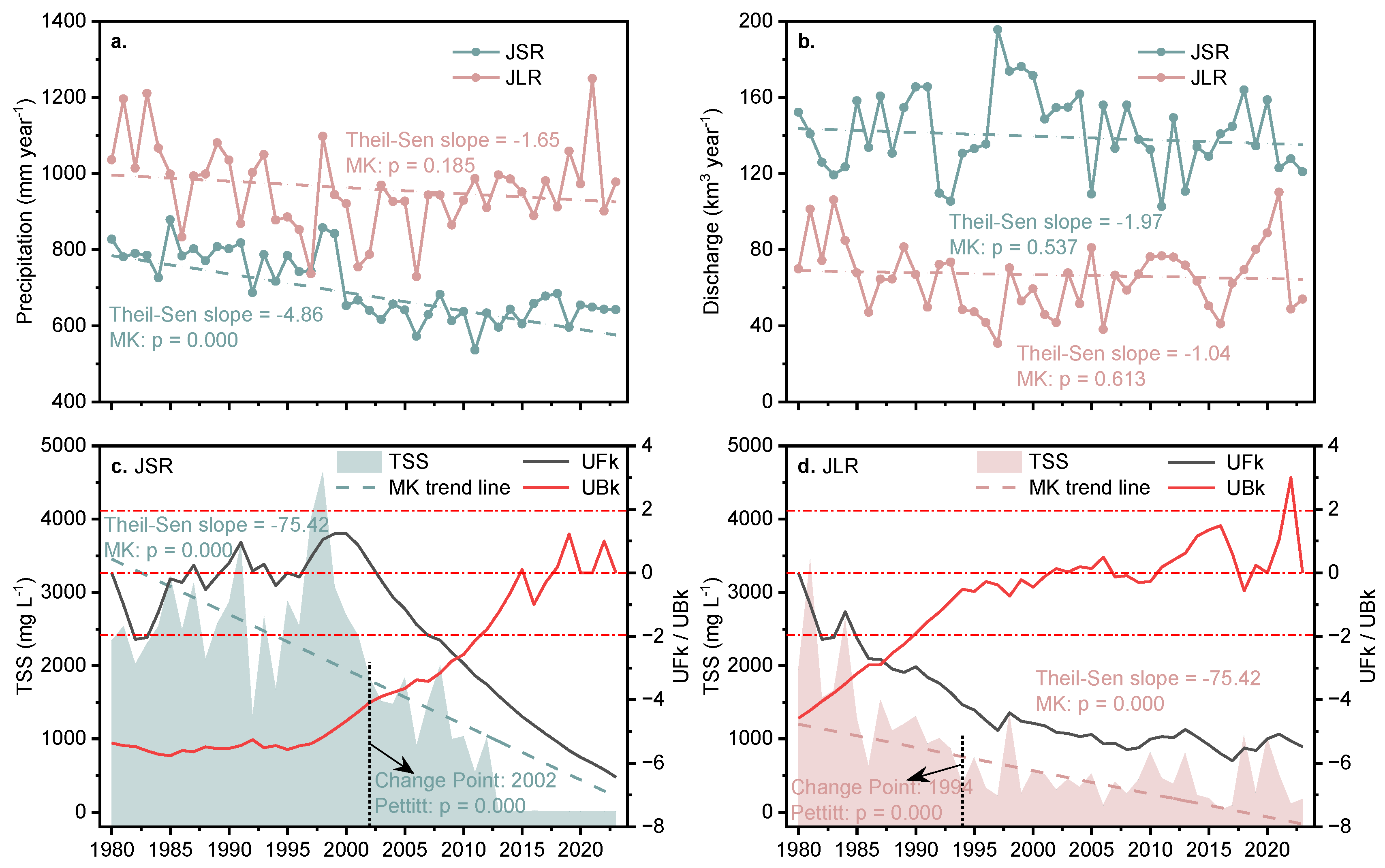
3.1. Precipitation, Flow Discharge, and Total Suspended Sediment Content

During the 44-year study period, the annual precipitation of the two basins exhibited similar coefficients of variation but demonstrated different temporal trends. The JSR Basin had an average annual precipitation of 703.8 ± 86.6 mm year−1, ranging from 536.1 mm year−1 in 2011 to 878.3 mm year−1 in 1985, with a coefficient of variation of approximately 12%. The JLR Basin exhibited significantly higher annual precipitation (Wilcoxon: p = 0.000), averaging 960.1 ± 111.9 mm year−1, with a range of 729.6 (in 2006)–1248.8 mm year−1 (in 2021), also resulting in a coefficient of variation of approximately 12%. Notably, although the JSR Basin displayed a statistically significant decreasing trend in annual precipitation (MK test: p = 0.000), the JLR Basin did not exhibit a discernible temporal trend (Figure 2a).
The spatiotemporal patterns of discharge in the two basins were not consistent with those of precipitation. The JSR Basin had an annual discharge range of 102.7 km3 year−1 in 2011 to 195.4 km3 year−1 in 1997 (the corresponding runoff depth was 187.2–356.2 mm year−1), with a coefficient of variation of approximately 15%. The JLR Basin had an annual discharge range of 30.7 km3 year−1 in 1997 to 110.1 km3 year−1 in 2021 (the corresponding runoff depth was 196.2–702.6 mm year−1), with a coefficient of variation of approximately 27%. Although the JSR Basin has a significantly higher total water discharge owing to its larger basin area (Wilcoxon test: p = 0.000), the JLR Basin typically has a higher runoff depth (Wilcoxon test: p = 0.000). In addition, no significant temporal trends in discharge or runoff depth were observed in either basin (Figure 2b).
A significant reduction in the TSS content was observed in both basins; however, the trajectory of this change exhibited distinct patterns for each basin (Figure 2c,d). The JSR Basin had an average annual TSS content of 1689 ± 1266 mg L−1, ranging from ~5 mg L−1 in several years after 2015 to 4640 mg L−1 in 1998, with a coefficient of variation of approximately 75%. The JLR Basin had an average annual TSS content of 780 ± 698 mg L−1, ranging from 26 mg L−1 in 2016 to 3450 mg L−1 in 1981, with a coefficient of variation of approximately 89%. The MK test indicated a sustained and significant decline in sediment delivery for the JSR post-2007 and for the JLR as early as 1985, with no abrupt points identified for either river. The Pettitt test revealed abrupt changes in the JSR in 2002 and the JLR in 1994. By comparing the average of the last 10 years (2014–2023) with the initial 10 years (1980–1989), the TSS content exported from the two basins was reduced by 99.6% for the JSR and 78.4% for the JLR. Another noteworthy point is that the TSS content of the JSR was typically higher than that of the JLR until 2013; however, this pattern was reversed post-2013, with the JLR surpassing the JSR in TSS content.

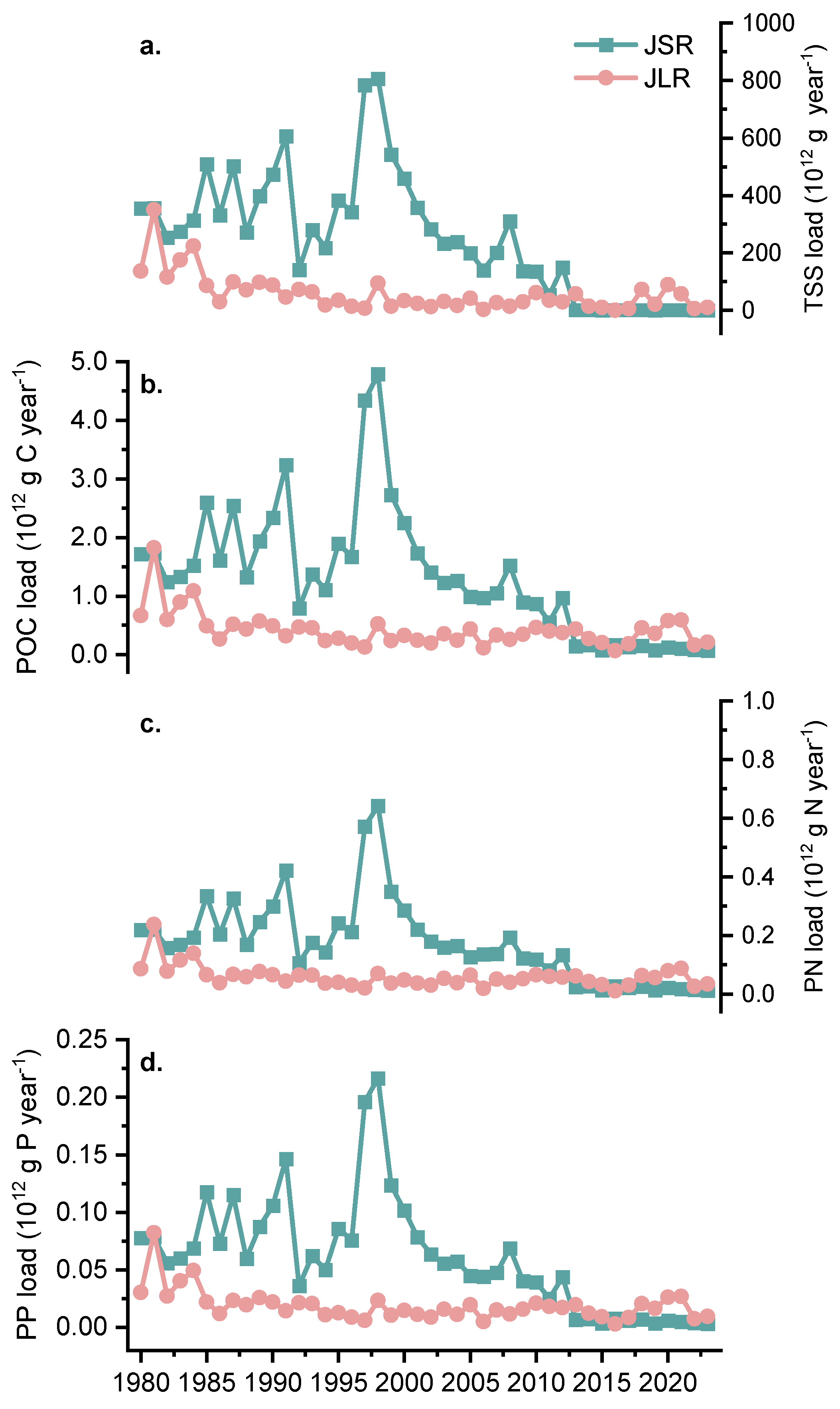
3.2. Downstream Fluxes of Sediment and Associated Particulate C, N, and P

Based on Equations (1)–(3), we computed the downstream fluxes of the sediment and associated particulate C, N, and P from the JSR and JLR Basins (Figure 3). As the particulate C, N, and P fluxes in this study were calculated based on their empirical statistical relationship with TSS content, the calculated fluxes of particulate C, N, and P varied quite similarly to those of the TSS fluxes, with abrupt changes in their export loads occurring in 2003 in the JSR and in 1994 in the JLR. In the past 44 years, the sediment export load in the JSR ranged from 0.604 to 806.5 Tg year−1 (1 Tg = 1012 g); the associated C, N, and P loads varied from 0.073 to 4.787 Tg C year−1, from 0.012 to 0.641 Tg N year−1, and from 0.003 to 0.217 Tg P year−1, respectively. The sediment export load in the JLR varied from 1.068 to 349.2 Tg year−1, with associated C, N, and P loads of 0.067–1.821 Tg C year−1, 0.011–0.236 Tg N year−1, and 0.003–0.082 Tg P year−1, respectively.
Although the overall decreasing trend was consistent, an inconsistent temporal variation in the particulate material fluxes was observed in the two rivers. The export loads of particulate materials in the JSR experienced a fluctuating increase between 1980 and 1998 and peaked in 1998; subsequently, they decreased significantly from 1999 until they stabilized relatively well after 2013. The reduction in particulate material fluxes in the JLR occurred much earlier, after the first 5 years of the study period. Moreover, the reduction in particulate material flux in the JSR was greater than that in the JLR. During 1980–2012, the particulate material loads of the JSR were generally higher than those of the JLR; however, during 2013–2023, the particulate material loads of the JLR became higher than those of the JSR.
The decrease rates and magnitudes of particulate material fluxes were different in these two basins. According to the Theil Sen trend lines from the MK test, the decrease rates of total TSS, POC, PN, and PP export loads were 10.67 Tg year−1, 0.050 Tg C year−1, 0.006 Tg N year−1, and 0.002 Tg P year−1, respectively, for the JSR, and 2.01 Tg year−1, 0.007 Tg C year−1, 0.0008 Tg N year−1, and 0.0003 Tg P year−1, respectively, for the JLR. By comparing the average of the recent 10 years (2014–2023) with the initial 10 years (1980–1989), the particulate material export loads were reduced by 90.9–99.6% for the JSR and 54.0–79.3% for the JLR.

4. Discussion

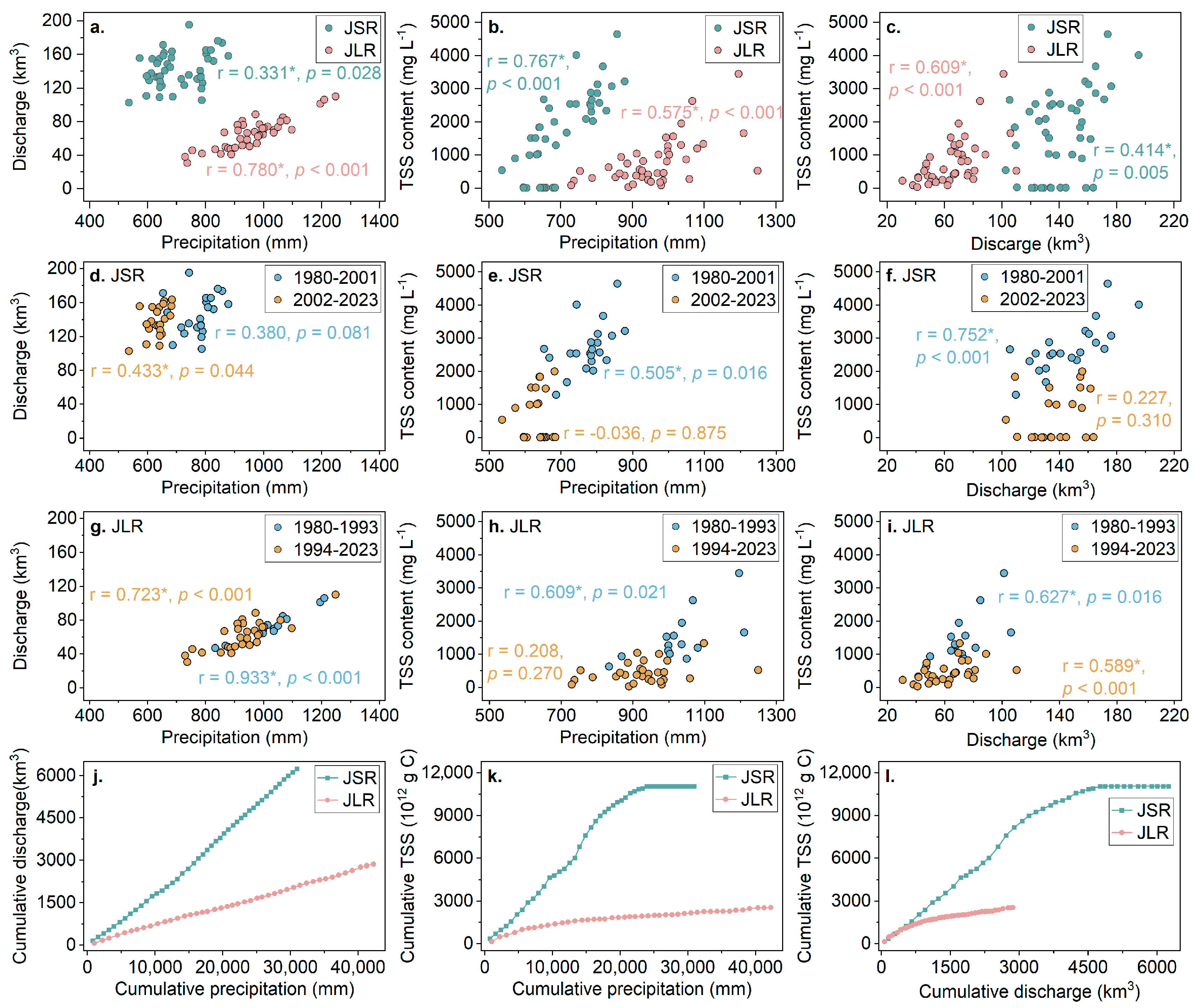
4.1. Changes in the Relationship Between Precipitation, Discharge, and Sediment Content

Precipitation is generally considered an important natural factor driving fluvial sediment transport, especially in areas with serious soil erosion, such as the area of this study [55,56]. Our findings showed significant positive correlations between precipitation, discharge, and TSS content in the JSR and JLR (Figure 4a–c), indicating the significant effects of precipitation on fluvial particulate matter transport. However, when comparing the periods before and after the abrupt TSS changes, there were differences in these relationships between the two periods, reflecting temporal variations in the effects of precipitation and discharge on TSS content (Figure 4d–i).
In the two periods before and after the abrupt TSS changes, these precipitation–discharge correlations differed between the two basins (Figure 4d,g), possibly reflecting differences in basin characteristics and spatial heterogeneity in the driving role of precipitation on discharge variation. More strikingly, however, the changes in the precipitation–TSS and discharge–TSS relationships were similar in the two basins (Figure 4e,f,h,i). Before the abrupt TSS content change, both precipitation and discharge showed significant positive correlations with TSS content. After the abrupt change, these correlations either became non-significant (JSR) or weakened (JLR). This dichotomy suggests a substantial attenuation of the impact of precipitation and runoff on sediment content in the latter period relative to the former.
The generation of surface runoff and the sediment it transports result from a complex interplay between precipitation and various factors such as surface hydrogeology and vegetation cover within a watershed [57,58,59]. The double cumulative curves further highlight the divergent relationships between these parameters in the two basins and underscore the diminishing role of precipitation and discharge in driving sediment dynamics over the past four decades (Figure 4j–l). Spatially, the slopes of the curves in the JSR Basin tend to be steeper than those in the JLR Basin, suggesting that the influence of precipitation on both discharge and TSS, as well as the effect of discharge on TSS content, was more pronounced in the JSR Basin. Temporally, the impact of precipitation on discharge remained largely unchanged, whereas the influences of both precipitation and discharge on sediment transport exhibited a diminishing trend in both basins. These findings suggest that the influence of natural factors, particularly precipitation, on river sediment transport has decreased over the last 44 years and indirectly indicate that human activities such as land use changes and dam construction have significantly increased their influence on sediment transport.

4.2. Anthropogenic Impacts on Riverine Sediment and Particulate C, N, and P Flux

The preceding analysis demonstrated that the influence of natural factors, represented by precipitation, on river particulate material fluxes diminished over time, thereby implying an augmented contribution of anthropogenic factors to the reduction in sediment and particulate elements. Land use change and dam construction were considered in this study to represent two major aspects of anthropogenic impacts on riverine material fluxes. At the basin scale, land use changes altered the scouring dynamics of surface runoff, influencing the quantity of particulate matter transported from land to rivers [2,60,61,62,63]. Conversely, dam interception operates on materials that have already been conveyed from land to rivers, resulting in substantial retention of particulate materials within river sediments or their transformation into alternative forms, thereby diminishing exports at the basin outlet [64,65,66,67]. Consequently, this study further analyzed the relationship of land use change and dam construction with riverine particulate material export in the JSR and JLR basins.

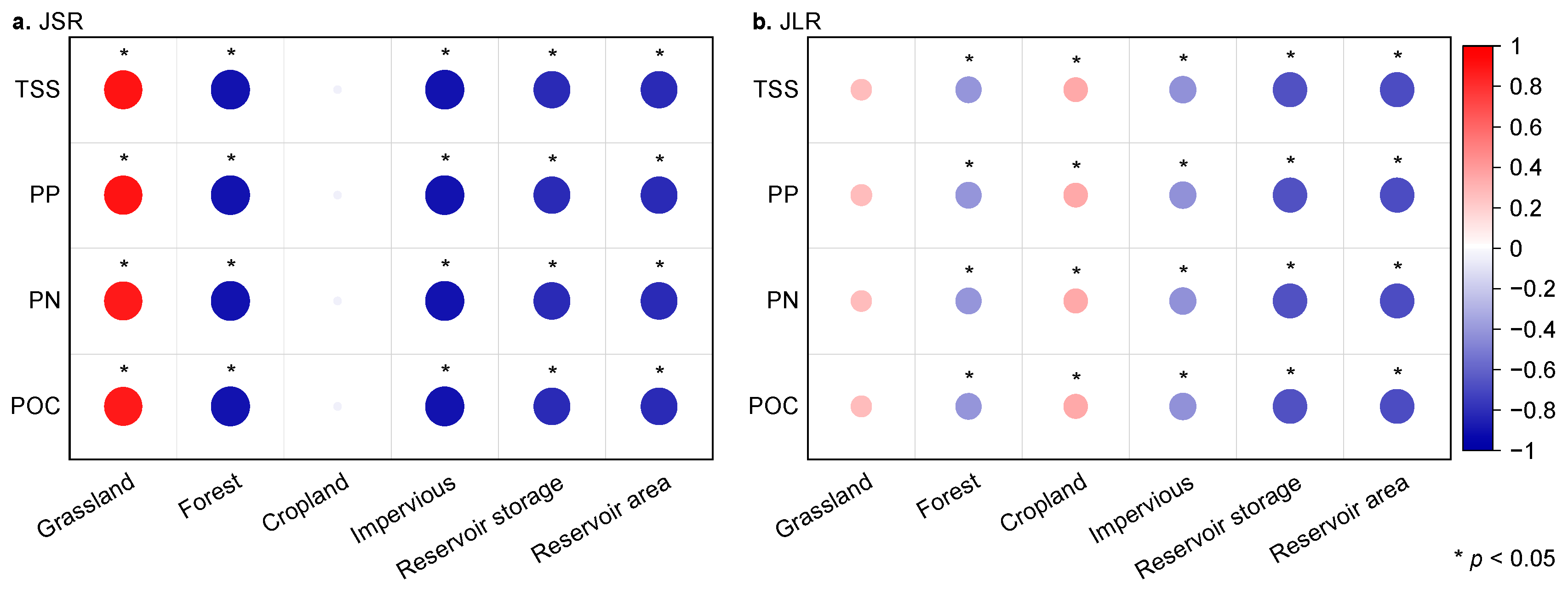
4.2.1. Impacts of Land Use Change

Land use is a critical factor influencing the sources of particulate matter transported from land to rivers. This study examined the relationships between four predominant land use types—forests, grasslands, croplands, and impervious surfaces—and riverine particulate material exports (Figure 5 and Figure 6). Forests, croplands, and grasslands are the primary land use types, collectively constituting over 94% of the basin area. Impervious surfaces, although covering a smaller portion of the landscape (<0.2% in the JSR Basin and <2% in the JLR Basin), serve as direct indicators of changes in the intensity of anthropogenic activity.
In both basins, the forested and impervious surfaces exhibited significant negative correlations with the export coefficients of particulate materials. This is straightforward. Forests are highly effective at reducing soil erosion. Forest cover constituted a major proportion (27–31% in the JSR Basin and 43–52% in the JLR Basin) and showed a significant increasing trend over time (MK test, p < 0.05). Although impervious surfaces cover a relatively minor fraction of the total area, their area expansion (MK test: p < 0.05) can still have a considerable impact on land–water sediment and nutrient transport. Conversion of natural surfaces to impervious surfaces can alter runoff erosion and hydrologic processes at the watershed scale, for example, by greatly reducing the time tag between surface runoff and precipitation, and also by reducing surface soil scouring by surface runoff (although it may increase the amount of surface runoff) [47,68,69]. Studies in specific watersheds with different characteristics are needed to explore the spatial and temporal heterogeneity of this effect.
Moreover, in the JSR Basin, grassland coverage exhibited a significant positive correlation with riverine particulate matter, whereas this correlation is insignificant in the JLR Basin. Conversely, farmland showed a significant positive correlation in the JLR Basin but an insignificant correlation in the JSR Basin. These findings suggest that both grassland and farmland have the potential to contribute substantially to the export of riverine particulate matter; however, their contributions may be masked by other factors when their proportional coverage within the basin is below a certain threshold. In the JSR Basin, grassland is the dominant land use type, covering 54–58% of the area, while cropland constitutes less than 10%. In contrast, the JLR Basin is dominated by cropland, accounting for 37–45% of the area, with grassland covering less than 10%. In recent decades, both grasslands and croplands have exhibited decreasing trends in both basins. This reduction may lead to a decrease in the particulate matter input from land to rivers, as both grasslands and farmlands are generally more susceptible to soil erosion than forests [68,70,71].
Furthermore, the intensity of the correlation between land use patterns and particulate matter export coefficients exhibited variability across different river basins, underscoring the distinct hydrological and geomorphological characteristics inherent to each basin. The significant correlation coefficients between land use and particulate matter export were generally higher in the JSR Basin than in the JLR Basin. This disparity suggests a potentially more pronounced influence of land use on the concentration of riverine particulate matter within the JSR Basin, reflecting a stronger link between land management practices and fluvial sediment dynamics in this region.

4.2.2. Impacts of Dams and Reservoirs

The negative effects of dam and reservoir construction on river sediment and particulate matter fluxes have been widely documented, particularly for rivers in the Northern Hemisphere. Dam retention has resulted in a decrease in sediment fluxes to 49% of pre-dam levels in the global hydrological north [9]. Both rivers in this study have experienced intense cascading developments in recent decades. Total reservoir capacity has increased from 2.17 km3 in the JSR (corresponding to a reservoir surface area of 104 km2) and 2.71 km3 in the JLR (corresponding to a reservoir surface area of 202 km2) in 1980 to the current values of ~66 km3 in the JSR (corresponding to a reservoir surface area of 1185 km2) and ~19 km3 in the JLR (corresponding to a reservoir surface area of 913 km2) (Figure 6). The reservoir capacity as a percentage of annual water discharge increased dramatically from 1.5% (JSR) and 5% (JLR) in the 1980s to approximately 50% (JSR) and 30% (JLR).
The Pettitt test identified an abrupt change in the proportion of total reservoir capacity to annual water discharge in 2001 in both basins; the proportion was 6.3% in the JSR and 17.4% in the JLR. This time is consistent with the changes in the TSS flux in the JSR but is seven years later than that in the JLR. The TSS flux of the JLR changed abruptly in 1994 when the cumulative reservoir capacity accounted for ~10% of the annual water discharge. When the abrupt changes in TSS content occurred in the JSR and JLR, the proportion of reservoir storage relative to annual discharge in both basins was higher than the proportion identified in previous studies across the entire Yangtze River basin. Previous studies on the Yangtze River have suggested that a substantial reduction in sediment load, including the particulate nutrients associated with the sediment, may occur when the cumulative reservoir capacity reaches 4% of the discharge [28]. The differences observed can be attributed to various factors; however, they still provide valuable scientific evidence for exploring potential threshold effects.
Based on the most recently acquired time series data on reservoir capacity and reservoir surface area, we observed a significant negative correlation between the two and the particulate matter export coefficients, which is in line with our expectations. However, an in-depth exploration of the strength of the correlation revealed subtle differences in the effects of reservoirs and land use on particulate matter export in different basins. In the JSR Basin, the correlation coefficients between the reservoir parameters and the particulate matter export coefficient were comparable to those between land use and the particulate matter export coefficient. This suggests that the abilities of reservoirs and land use to influence changes in particulate matter export in the JSR Basin were comparable. In comparison, the situation in the JLR Basin is different. In this basin, the correlation coefficients of reservoir parameters with particulate matter export coefficients were significantly higher than those of land use with particulate matter export coefficients. This indicates that the effect of reservoirs on particulate matter transport was more remarkable in the JLR Basin, exceeding the strength of the effect of land use. The differences between these two basins further emphasize the complexity of the influencing mechanisms of riverine particulate matter export, which is largely due to the spatial heterogeneity of basin characteristics. Differences in natural conditions such as topography, geomorphology, climate, and hydrology, as well as differences in human activity patterns across basins, may have a profound impact on particulate matter export.

4.3. Limitations of This Study

The reduction in particulate matter flux significantly impacts nutrient and pollutant dynamics in rivers, posing a complex scientific challenge that requires careful consideration for future research and management. This study highlights the significant impacts on riverine particulate material flux but struggles with quantifying their contributions due to the difficulty in directly measuring terrestrial inputs to rivers and dam retention. Moreover, this study also failed to differentiate in evaluating the physical impacts of dams (such as sediment retention) and the impacts related to management methods (such as regulated releases, flow seasonality). It represents an important direction for future research.
Furthermore, reconstructing long-term data series also poses substantial challenges. In China, the absence of routine carbon monitoring in rivers and the failure to differentiate between dissolved and particulate forms of nitrogen and phosphorus further limit data availability. Due to the lack of long-term, localized historical monitoring data, we are unable to directly calculate export fluxes based on monitoring data, nor can we establish basin-specific or time-specific relationships between TSS and particulate C, N, and P. Consequently, we employ published global empirical models for estimation, a common practice in large-scale flux reconstructions when in situ data are unavailable. It is crucial to acknowledge that parameters and relationships derived from global-scale datasets may introduce bias when applied to individual basins, as these relationships can vary not only spatially but also temporally, even within the same region. For instance, the relationship between TSS and particulate nutrients may differ across seasons or before and after abrupt TSS concentration change. These global empirical models may not fully capture the local and seasonal variability of the investigated basins, thereby introducing unquantifiable uncertainties into our estimates. However, this is an unresolvable gap. The historical relationship cannot be truly reestablished by the complementary monitoring that is now present. Therefore, despite acknowledged basin-specific variations, these global empirical formulas provide reasonable first-order estimates, effectively addressing knowledge gaps in the absence of localized models. To address these limitations, concurrent development of field monitoring and modeling is essential. More extensive routine monitoring and the development of regional adaptive models that integrate multiple processes of input, retention, and export are important elements of future research, aiming for more accurate and comprehensive insights into the ecological effects of particulate flux reduction.

5. Conclusions

This study quantifies fluvial sediment and particulate C, N, and P exports from the JSR and JLR, two traditional high-sediment rivers in the upper reaches of the Yangtze River in Southwest China, under the influence of land use changes and cascade development. Over the 44-year study period, despite stable annual discharge, both rivers experienced significant reductions in TSS and associated biogenic elements. In the JSR, the export loads of TSS, POC, PN, and PP were 0.604–806.5 Tg year−1, 0.073–4.787 Tg C year−1, 0.012–0.641 Tg N year−1, and 0.003–0.217 Tg P year−1, respectively, with a greater decrease and a more recent abrupt change (2002–2003). However, in the JLR, the export loads of TSS, POC, PN, and PP were 1.068–349.2 Tg year−1, 0.067–1.821 Tg C year−1, 0.011–0.236 Tg N year−1, and 0.003–0.082 Tg P year−1, respectively, with earlier abruptions but a relatively lower percentage of decrease. This study reveals that anthropogenic influences, particularly land use change and dam construction, have become increasingly dominant. Increases in forests, impervious surfaces, and reservoirs, alongside reductions in grassland and farmland, have reduced particulate matter export from both rivers. Reservoirs’ influence on particulate matter export may be comparable to land use in the JSR Basin but exceed that of land use in the JLR Basin.
This research highlights the profound impacts of land use change and dam construction on sediment and associated particulate C, N, and P exports in cascading developmental rivers, providing insights for effective environmental policies and management practices. Future planning should prioritize scientific land use assessment, forest protection and restoration, and controlled agricultural expansion to mitigate soil and nutrient loss. Concurrently, ongoing monitoring of impoundment effects and optimizing reservoir scheduling strategies are essential for supporting resilient basin management and addressing the challenges posed by land use and dam construction on riverine TSS and associated biogenic elements.

Author Contributions

Conceptualization, S.L.; methodology, S.L. and L.Z.; formal analysis, S.L. and L.Z.; investigation, Q.Y. and Y.W.; data curation, S.L., Q.Y., F.X., Y.W. and Z.D.; writing—original draft preparation, S.L.; writing—review and editing, S.L.; visualization, S.L.; supervision, L.L.; funding acquisition, S.L. All authors have read and agreed to the published version of the manuscript.

Funding

This research was funded by the Fundamental Research Funds for the Central Public-interest Scientific Institution (2023YSKY-11); the National Natural Science Foundation of China (42107422); and the Open Research Fund of State Environmental Protection Key Laboratory of Estuarine and Coastal Environment, Chinese Research Academy of Environmental Sciences (HKHA2022007).

Data Availability Statement

The original contributions presented in this study are included in the article. Further inquiries can be directed to the corresponding author.

Conflicts of Interest

The authors declare no conflicts of interest. The funders had no role in the design of the study; in the collection, analyses, or interpretation of data; in the writing of the manuscript; or in the decision to publish the results.

References

  1. Allen, G.H.; Pavelsky, T.M. Global extent of rivers and streams. Science 2018, 361, 585–588. [Google Scholar] [CrossRef] [PubMed]
  2. Best, J. Anthropogenic stresses on the world’s big rivers. Nat. Geosci. 2018, 12, 7–21. [Google Scholar] [CrossRef]
  3. Mayorga, E.; Seitzinger, S.P.; Harrison, J.A.; Dumont, E.; Beusen, A.H.W.; Bouwman, A.F.; Fekete, B.M.; Kroeze, C.; Van Drecht, G. Global Nutrient Export from WaterSheds 2 (NEWS 2): Model development and implementation. Environ. Model. Softw. 2010, 25, 837–853. [Google Scholar] [CrossRef]
  4. Montefiore, L.R.; Kaplan, D.; Phlips, E.J.; Milbrandt, E.C.; Arias, M.E.; Morrison, E.; Nelson, N.G. Downstream Nutrient Concentrations Depend on Watershed Inputs More Than Reservoir Releases in a Highly Engineered Watershed. Water Resour. Res. 2024, 60, e2023WR035590. [Google Scholar] [CrossRef]
  5. Mbabazi, J.; Inoue, T.; Yokota, K.; Saga, M. Variability of particulate bioavailable phosphorus, particulate organic carbon and nitrogen in agricultural and urban rivers. J. Environ. Chem. Eng. 2019, 7, 103086. [Google Scholar] [CrossRef]
  6. Beusen, A.H.W.; Dekkers, A.L.M.; Bouwman, A.F.; Ludwig, W.; Harrison, J. Estimation of global river transport of sediments and associated particulate C, N, and P. Glob. Biogeochem. Cycles 2005, 19, GB4S05. [Google Scholar] [CrossRef]
  7. Kunz, M.J.; Wüest, A.; Wehrli, B.; Landert, J.; Senn, D.B. Impact of a large tropical reservoir on riverine transport of sediment, carbon, and nutrients to downstream wetlands. Water Resour. Res. 2011, 47, W12531. [Google Scholar] [CrossRef]
  8. Fang, H.; He, G.; Huang, L.; Zhao, C.; Wang, J.; Han, Y.; Gao, Q.; Zhang, T.; Meng, J. Altered flow and sediment transport impacts on the ecosystems of Chinese major rivers: An urgent call for eco-fluvial dynamics. River 2024, 3, 341–361. [Google Scholar] [CrossRef]
  9. Dethier, E.N.; Renshaw, C.E.; Magilligan, F.J. Rapid changes to global river suspended sediment flux by humans. Science 2022, 376, 1447–1452. [Google Scholar] [CrossRef]
  10. Repasch, M.; Scheingross, J.S.; Hovius, N.; Lupker, M.; Wittmann, H.; Haghipour, N.; Gröcke, D.R.; Orfeo, O.; Eglinton, T.I.; Sachse, D. Fluvial organic carbon cycling regulated by sediment transit time and mineral protection. Nat. Geosci. 2021, 14, 842–848. [Google Scholar] [CrossRef]
  11. Bianchi, T.S.; Mayer, L.M.; Amaral, J.H.F.; Arndt, S.; Galy, V.; Kemp, D.B.; Kuehl, S.A.; Murray, N.J.; Regnier, P. Anthropogenic impacts on mud and organic carbon cycling. Nat. Geosci. 2024, 17, 287–297. [Google Scholar] [CrossRef]
  12. Vörösmarty, C.J.; Meybeck, M.; Fekete, B.; Sharma, K.; Green, P.; Syvitski, J.P.M. Anthropogenic sediment retention: Major global impact from registered river impoundments. Glob. Planet. Change 2003, 39, 169–190. [Google Scholar] [CrossRef]
  13. Liu, X.; Bao, Y.; Wang, Y.; Zhang, D.; Hu, M.; Wu, X.; Wen, J.; Li, S.; Sun, M. Spatiotemporal variation characteristics of sediment nutrient load from the soil erosion of the Yangtze River Basin of China from 1901 to 2010. Ecol. Indic. 2023, 150, 110206. [Google Scholar] [CrossRef]
  14. Chu, Z.X.; Zhai, S.K.; Lu, X.X.; Liu, J.P.; Xu, J.X.; Xu, K.H. A quantitative assessment of human impacts on decrease in sediment flux from major Chinese rivers entering the western Pacific Ocean. Geophys. Res. Lett. 2009, 36, L19603. [Google Scholar] [CrossRef]
  15. Kumwimba, M.N.; Bao, L.; Jie, Z.; Li, X.; Huang, J.; Wang, W.; Li, X.; Su, J.; Muyembe, D.K.; Guide, A.; et al. Nutrients retention of a series of small dam-impacted urban rivers in northern China. J. Environ. Chem. Eng. 2022, 10, 107967. [Google Scholar] [CrossRef]
  16. Meade, R.H. River-Sediment Inputs to Major Deltas. In Sea-Level Rise and Coastal Subsidence; Milliman, J.D., Haq, B.U., Eds.; Coastal Systems and Continental Margins; Springer Netherlands: Dordrecht, The Netherlands, 1996; pp. 63–85. [Google Scholar]
  17. Sun, X.; Tian, L.; Fang, H.; Walling, D.E.; Huang, L.; Park, E.; Li, D.; Zheng, C.; Feng, L. Changes in global fluvial sediment concentrations and fluxes between 1985 and 2020. Nat. Sustain. 2025, 8, 142–151. [Google Scholar] [CrossRef]
  18. Wang, Y.; Junaid, M.; Deng, J.-Y.; Tang, Q.; Luo, L.; Xie, Z.; Pei, D. Effects of land-use patterns on seasonal water quality at multiple spatial scales in the Jialing River, Chongqing, China. Catena 2024, 234, 107646. [Google Scholar] [CrossRef]
  19. Wang, Y.; Li, H.; Xu, Z. Rainfall-induced nutrient losses from manure-fertilized farmland in an alluvial plain. Environ. Monit. Assess. 2016, 188, 8. [Google Scholar] [CrossRef]
  20. Zhou, Y.; Li, D.; Lu, J.; Yao, S.; Yan, X.; Jin, Z.; Liu, L.; Lu, X.X. Distinguishing the multiple controls on the decreased sediment flux in the Jialing River basin of the Yangtze River, Southwestern China. Catena 2020, 193, 104593. [Google Scholar] [CrossRef]
  21. Riquetti, N.B.; Beskow, S.; Guo, L.; Mello, C.R. Soil erosion assessment in the Amazon basin in the last 60 years of deforestation. Environ. Res. 2023, 236, 116846. [Google Scholar] [CrossRef]
  22. Zheng, F.; He, X.; Gao, X.; Zhang, C.-E.; Tang, K. Effects of erosion patterns on nutrient loss following deforestation on the Loess Plateau of China. Agric. Ecosyst. Environ. 2005, 108, 85–97. [Google Scholar] [CrossRef]
  23. Mirauda, D.; Caniani, D.; Colucci, M.T.; Ostoich, M. Assessing the fluvial system resilience of the river Bacchiglione to point sources of pollution in Northeast Italy: A novel Water Resilience Index (WRI) approach. Environ. Sci. Pollut. Res. Int. 2021, 28, 36775–36792. [Google Scholar] [CrossRef]
  24. Van Cappellen, P.; Maavara, T. Rivers in the Anthropocene: Global scale modifications of riverine nutrient fluxes by damming. Ecohydrol. Hydrobiol. 2016, 16, 106–111. [Google Scholar] [CrossRef]
  25. Spinti, R.A.; Condon, L.E.; Zhang, J. The evolution of dam induced river fragmentation in the United States. Nat. Commun. 2023, 14, 3820. [Google Scholar] [CrossRef] [PubMed]
  26. Tian, Q.; Xu, K.H.; Dong, C.M.; Yang, S.L.; He, Y.J.; Shi, B.W. Declining Sediment Discharge in the Yangtze River from 1956 to 2017: Spatial and Temporal Changes and Their Causes. Water Resour. Res. 2021, 57, e2020WR028645. [Google Scholar] [CrossRef]
  27. Yang, H.F.; Yang, S.L.; Xu, K.H.; Milliman, J.D.; Wang, H.; Yang, Z.; Chen, Z.; Zhang, C.Y. Human impacts on sediment in the Yangtze River: A review and new perspectives. Glob. Planet. Change 2018, 162, 8–17. [Google Scholar] [CrossRef]
  28. Guo, C.; Jin, Z.; Guo, L.; Lu, J.; Ren, S.; Zhou, Y. On the cumulative dam impact in the upper Changjiang River: Streamflow and sediment load changes. Catena 2020, 184, 104250. [Google Scholar] [CrossRef]
  29. Shalash, S. Effects of sedimentation on the storage capacity of the High Aswan Dam reservoir. Hydrobiologia 1982, 91–92, 623–639. [Google Scholar] [CrossRef]
  30. Walling, D.E. Human impact on land–ocean sediment transfer by the world’s rivers. Geomorphology 2006, 79, 192–216. [Google Scholar] [CrossRef]
  31. Ve, N.D.; Fan, D.; Van Vuong, B.; Lan, T.D. Sediment budget and morphological change in the Red River Delta under increasing human interferences. Mar. Geol. 2021, 431, 106379. [Google Scholar] [CrossRef]
  32. Lu, X.X.; Oeurng, C.; Le, T.P.Q.; Thuy, D.T. Sediment budget as affected by construction of a sequence of dams in the lower Red River, Viet Nam. Geomorphology 2015, 248, 125–133. [Google Scholar] [CrossRef]
  33. Binh, D.V.; Kantoush, S.; Sumi, T. Changes to long-term discharge and sediment loads in the Vietnamese Mekong Delta caused by upstream dams. Geomorphology 2020, 353, 107011. [Google Scholar] [CrossRef]
  34. Charoenlerkthawin, W.; Namsai, M.; Bidorn, K.; Rukvichai, C.; Panneerselvam, B.; Bidorn, B. Effects of Dam Construction in the Wang River on Sediment Regimes in the Chao Phraya River Basin. Water 2021, 13, 2146. [Google Scholar] [CrossRef]
  35. Chong, X.Y.; Vericat, D.; Batalla, R.J.; Teo, F.Y.; Lee, K.S.P.; Gibbins, C.N. A review of the impacts of dams on the hydromorphology of tropical rivers. Sci. Total Environ. 2021, 794, 148686. [Google Scholar] [CrossRef] [PubMed]
  36. Wu, Z.; Zhao, D.; Syvitski, J.P.M.; Saito, Y.; Zhou, J.; Wang, M. Anthropogenic impacts on the decreasing sediment loads of nine major rivers in China, 1954–2015. Sci. Total Environ. 2020, 739, 139653. [Google Scholar] [CrossRef]
  37. Duan, L.; Tian, Y.; Zhang, S.; Wang, X.; Li, C.; Chen, M. Statistical studies of the characteristics and key influencing factors of sediment changes in the upper Yangtze River over the past 60 years. Geomorphology 2024, 466, 109414. [Google Scholar] [CrossRef]
  38. Peng, S. 1-km Monthly Precipitation Dataset for China (1901–2023) [Data Set]; National Tibetan Plateau/Third Pole Environment Data Center: Online, 2024. [Google Scholar] [CrossRef]
  39. Ding, Y.; Peng, S. Spatiotemporal Trends and Attribution of Drought across China from 1901–2100. Sustainability 2020, 12, 477. [Google Scholar] [CrossRef]
  40. Peng, S.; Ding, Y.; Liu, W.; Li, Z. 1 km monthly temperature and precipitation dataset for China from 1901 to 2017. Earth Syst. Sci. Data 2019, 11, 1931–1946. [Google Scholar] [CrossRef]
  41. Peng, S.; Ding, Y.; Wen, Z.; Chen, Y.; Cao, Y.; Ren, J. Spatiotemporal change and trend analysis of potential evapotranspiration over the Loess Plateau of China during 2011–2100. Agric. For. Meteorol. 2017, 233, 183–194. [Google Scholar] [CrossRef]
  42. Peng, S.; Gang, C.; Cao, Y.; Chen, Y. Assessment of climate change trends over the Loess Plateau in China from 1901 to 2100. Int. J. Climatol. 2017, 38, 2250–2264. [Google Scholar] [CrossRef]
  43. Song, C.; Fan, C.; Zhu, J.; Wang, J.; Sheng, Y.; Liu, K.; Chen, T.; Zhan, P.; Luo, S.; Yuan, C.; et al. A comprehensive geospatial database of nearly 100 000 reservoirs in China. Earth Syst. Sci. Data 2022, 14, 4017–4034. [Google Scholar] [CrossRef]
  44. Yang, J.; Huang, X. The 30 m annual land cover dataset and its dynamics in China from 1990 to 2019. Earth Syst. Sci. Data 2021, 13, 3907–3925. [Google Scholar] [CrossRef]
  45. Yang, J.; Huang, X. The 30 m annual land cover datasets and its dynamics in China from 1985 to 2023 [Data set]. Earth Syst. Sci. Data (1.0.3). Zenodo 2024, 13, 3907–3925. [Google Scholar] [CrossRef]
  46. Seitzinger, S.P.; Harrison, J.A.; Dumont, E.; Beusen, A.H.W.; Bouwman, A.F. Sources and delivery of carbon, nitrogen, and phosphorus to the coastal zone: An overview of Global Nutrient Export from Watersheds (NEWS) models and their application. Glob. Biogeochem. Cycles 2005, 19, GB4S01. [Google Scholar] [CrossRef]
  47. Luo, X.; Bai, X.; Tan, Q.; Ran, C.; Chen, H.; Xi, H.; Chen, F.; Wu, L.; Li, C.; Zhang, S.; et al. Particulate organic carbon exports from the terrestrial biosphere controlled by erosion. Catena 2022, 209, 105815. [Google Scholar] [CrossRef]
  48. Qu, H.J.; Kroeze, C. Past and future trends in nutrients export by rivers to the coastal waters of China. Sci. Total Environ. 2010, 408, 2075–2086. [Google Scholar] [CrossRef]
  49. Chen, D.; Liu, Q.; Xu, J.; Wang, K. Model-Based Evaluation of Hydroelectric Dam’s Impact on the Seasonal Variabilities of POC in Coastal Ocean: A Case Study of Three Gorges Project. J. Mar. Sci. Eng. 2019, 7, 320. [Google Scholar] [CrossRef]
  50. Zhu, X.; Yu, G.; Gao, Y.; Wang, Q. Fluxes of particulate carbon from rivers to the ocean and their changing tendency in China. Prog. Geogr. 2012, 31, 118–122. (In Chinese) [Google Scholar] [CrossRef]
  51. Mann, H.B. Nonparametric Tests Against Trend. Econometrica 1945, 13, 245–259. [Google Scholar] [CrossRef]
  52. Kendall, M.G. Rank Correlation Methods; Griffin: Oxford, UK, 1948. [Google Scholar]
  53. Hussain, M.; Mahmud, I. pyMannKendall: A python package for non parametric Mann Kendall family of trend tests. J. Open Source Softw. 2019, 4, 1556. [Google Scholar] [CrossRef]
  54. Pettitt, A.N. A Non-Parametric Approach to the Change-Point Problem. Appl. Stat. 1979, 28, 126–135. [Google Scholar] [CrossRef]
  55. Chen, Z.; Li, J.; Shen, H.; Zhanghua, W. Yangtze River of China: Historical analysis of discharge variability and sediment flux. Geomorphology 2001, 41, 77–91. [Google Scholar] [CrossRef]
  56. Wei, J.; Hou, L.; He, X. An assessment of human versus climatic impacts on large-sized basin erosion: The case of the upper Yangtze River. Nat. Hazard. 2014, 74, 405–420. [Google Scholar] [CrossRef]
  57. Wang, Y.; Xu, H.; Zhao, X.; Kang, L.; Qiu, Y.; Paerl, H.; Zhu, G.; Li, H.; Zhu, M.; Qin, B.; et al. Rainfall impacts on nonpoint nitrogen and phosphorus dynamics in an agricultural river in subtropical montane reservoir region of southeast China. J. Environ. Sci. 2025, 149, 551–563. [Google Scholar] [CrossRef]
  58. Ye, Q.; Li, Z.; Duan, L.; Xu, X. Decoupling the influence of vegetation and climate on intra-annual variability in runoff in karst watersheds. Sci. Total Environ. 2022, 824, 153874. [Google Scholar] [CrossRef]
  59. Cai, L.; Chen, X.; Huang, R.; Smettem, K. Runoff change induced by vegetation recovery and climate change over carbonate and non-carbonate areas in the karst region of South-west China. J. Hydrol. 2022, 604, 127231. [Google Scholar] [CrossRef]
  60. Brath, A.; Montanari, A.; Moretti, G. Assessing the effect on flood frequency of land use change via hydrological simulation (with uncertainty). J. Hydrol. 2006, 324, 141–153. [Google Scholar] [CrossRef]
  61. Wang, G.; Zhang, J.; He, R.; Jiang, N.; Jing, X. Runoff reduction due to environmental changes in the Sanchuanhe river basin. Int. J. Sediment Res. 2008, 23, 174–180. [Google Scholar] [CrossRef]
  62. Jiang, L.; Yao, Z.; Liu, Z.; Wu, S.; Wang, R.; Wang, L. Estimation of soil erosion in some sections of Lower Jinsha River based on RUSLE. Nat. Hazard. 2015, 76, 1831–1847. [Google Scholar] [CrossRef]
  63. Jiang, C.; Xiong, L.; Wang, D.; Liu, P.; Guo, S.; Xu, C.-Y. Separating the impacts of climate change and human activities on runoff using the Budyko-type equations with time-varying parameters. J. Hydrol. 2015, 522, 326–338. [Google Scholar] [CrossRef]
  64. Wu, M.; Huang, S.; Wen, W.; Sun, X.; Tang, X.; Scholz, M. Nutrient distribution within and release from the contaminated sediment of Haihe River. J. Environ. Sci. 2011, 23, 1086–1094. [Google Scholar] [CrossRef] [PubMed]
  65. Guan, Q.; Feng, L.; Tang, J.; Park, E.; Ali, T.A.; Zheng, Y. Trends in River Total Suspended Sediments Driven by Dams and Soil Erosion: A Comparison Between the Yangtze and Mekong Rivers. Water Resour. Res. 2022, 58, e2022WR031979. [Google Scholar] [CrossRef]
  66. Guo, J.; Xie, Y.; Guan, A.; Qi, W.; Cao, X.; Peng, J.; Liu, H.; Wu, X.; Li, C.; Wang, D.; et al. Dam construction reshapes sedimentary pollutant distribution along the Yangtze River by regulating sediment composition. Environ. Pollut. 2023, 316, 120659. [Google Scholar] [CrossRef]
  67. Li, G.; Wang, X.T.; Yang, Z.; Mao, C.; West, A.J.; Ji, J. Dam-triggered organic carbon sequestration makes the Changjiang (Yangtze) river basin (China) a significant carbon sink. J. Geophys. Res. Biogeosci. 2015, 120, 39–53. [Google Scholar] [CrossRef]
  68. Zhang, H.; Lv, J.; Bao, Y.; Tang, Q.; Collins, A.L.; Khurram, D.; He, X. Linking soil erosion and sediment yield with landscape heterogeneity: Exploration using the lower Jinsha River Basin, China. J. Hydrol. 2024, 631, 130729. [Google Scholar] [CrossRef]
  69. Jordan, Y.C.; Ghulam, A.; Chu, M.L. Assessing the Impacts of Future Urban Development Patterns and Climate Changes on Total Suspended Sediment Loading in Surface Waters Using Geoinformatics. J. Environ. Inf. 2014, 24, 65–79. [Google Scholar] [CrossRef]
  70. Yan, R.; Zhang, X.; Yan, S.; Chen, H. Estimating soil erosion response to land use/cover change in a catchment of the Loess Plateau, China. Int. Soil Water Conserv. Res. 2018, 6, 13–22. [Google Scholar] [CrossRef]
  71. El Kateb, H.; Zhang, H.; Zhang, P.; Mosandl, R. Soil erosion and surface runoff on different vegetation covers and slope gradients: A field experiment in Southern Shaanxi Province, China. Catena 2013, 105, 1–10. [Google Scholar] [CrossRef]
Figure 1. Study area and station locations. (a) Overview of the Yangtze River Basin, highlighting the study area. The Datong gauging station represents the basin outlets of the Yangtze River. (b) Topographical elevation, major rivers, and the outlet (Xiangjiaba gauging station) of the Jinsha River Basin. (c) Topographical elevation, major rivers, and the outlet (Beibei gauging station) of the Jialing River Basin.
Water 17 01333 g001
Figure 2. Time series of annual precipitation (a), discharge (b), and TSS content (c,d) of the JSR and JLR basins (JSR: Jinsha River, JLR: Jialing River, MK: Mann–Kendall test, TSS: total suspended sediment, UFk and UBk: test statistics in MK test).
Water 17 01333 g002
Figure 3. Downstream export loads of TSS (a) and associated POC (b), PN (c), and PP (d) in the JSR and JLR basins (JSR: Jinsha River, JLR: Jialing River, TSS: total suspended sediment, POC: particulate organic carbon, PN: particulate nitrogen, PP: particulate phosphorus).
Water 17 01333 g003
Figure 4. Relationship between precipitation, discharge, and TSS content (ai) during different periods and double accumulative curves of precipitation–discharge (j), precipitation–TSS loads (k), and discharge–TSS loads (l) in the JSR and JLR basins during 1980–2023 (JSR: Jinsha River, JLR: Jialing River, TSS: total suspended sediment. * Correlation is significant.).
Water 17 01333 g004
Figure 5. Correlations between land use, reservoirs, and export coefficients of particulate materials in the JSR (a) and JLR (b) (JSR: Jinsha River, JLR: Jialing River, TSS: total suspended sediment, POC: particulate organic carbon, PN: particulate nitrogen, PP: particulate phosphorus).
Water 17 01333 g005
Figure 6. Land use change (a,c) and cumulative reservoir storage capacity and its proportion of annual water discharge (b,d) in the JSR and JLR basins (JSR: Jinsha River, JLR: Jialing River).
Water 17 01333 g006
Disclaimer/Publisher’s Note: The statements, opinions and data contained in all publications are solely those of the individual author(s) and contributor(s) and not of MDPI and/or the editor(s). MDPI and/or the editor(s) disclaim responsibility for any injury to people or property resulting from any ideas, methods, instructions or products referred to in the content.

