
Harnessing AHP and Fuzzy Scenarios for Resilient Flood Management in Arid Environments: Challenges and Pathways Toward Sustainability

 ,
,  ,
,  ,
,  and
and 
Abstract
1. Introduction
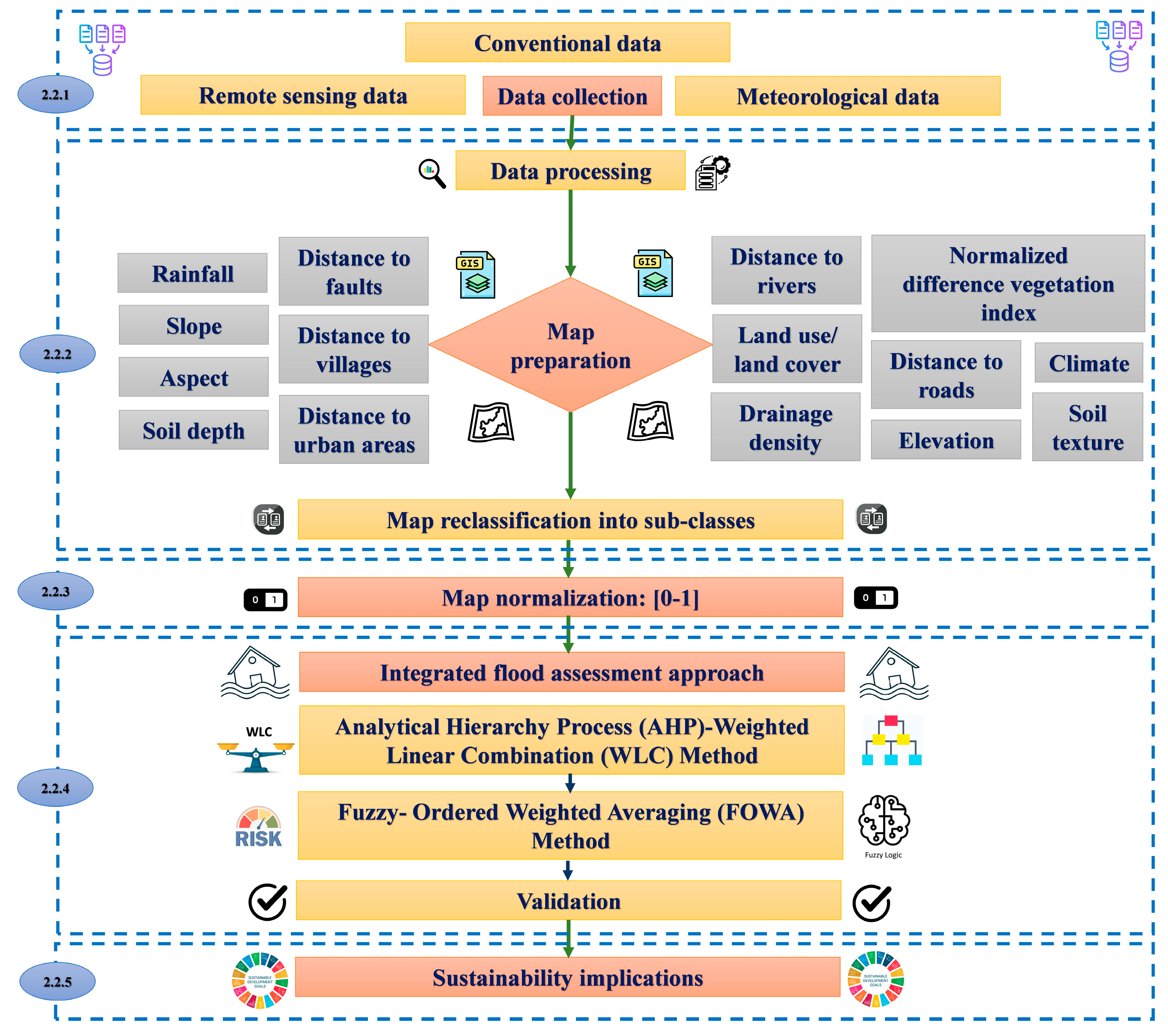
2. Materials and Methods
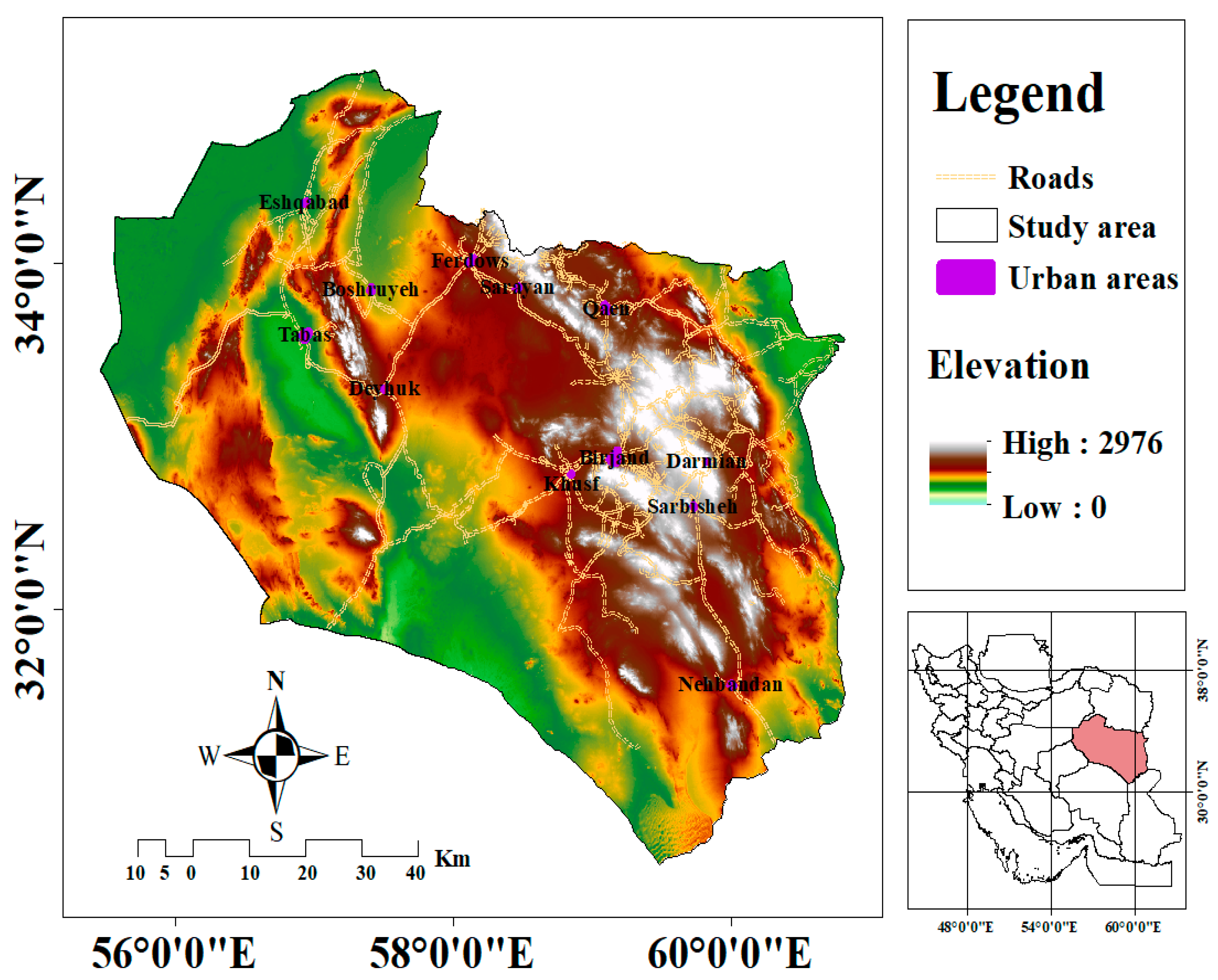
2.1. Study Area
2.2. Research Methodology
2.2.1. Data Collection

| Data Types | Source | Application | |
|---|---|---|---|
| Conventional data | Soil properties: (type and depth) | [40] | ST and SD maps |
| Location of faults | [34,41] | DTF map | |
| Remote sensing data | Digital elevation model (DEM) | [35] | DTR, ELE, SL, DD, and AS maps |
| Sentinel-2 satellite images | [34] | LU/LC, NDVI, and DTU maps | |
| Open street map | [36] | DTD and DTV maps | |
| Meteorological data | Rainfall values | [37,38] | RF map |
| Climatic characteristics | [42] | CL map | |
2.2.2. Map Preparation of the Flood Controlling Factors
- Distance to Rivers (DTR) Map
- Rainfall (RF) Map
- Slope (SL) Map
- Land Use/Land Cover (LU/LC) Map
- Normalized Difference Vegetation Index (NDVI) Map
- Elevation (ELE) Map
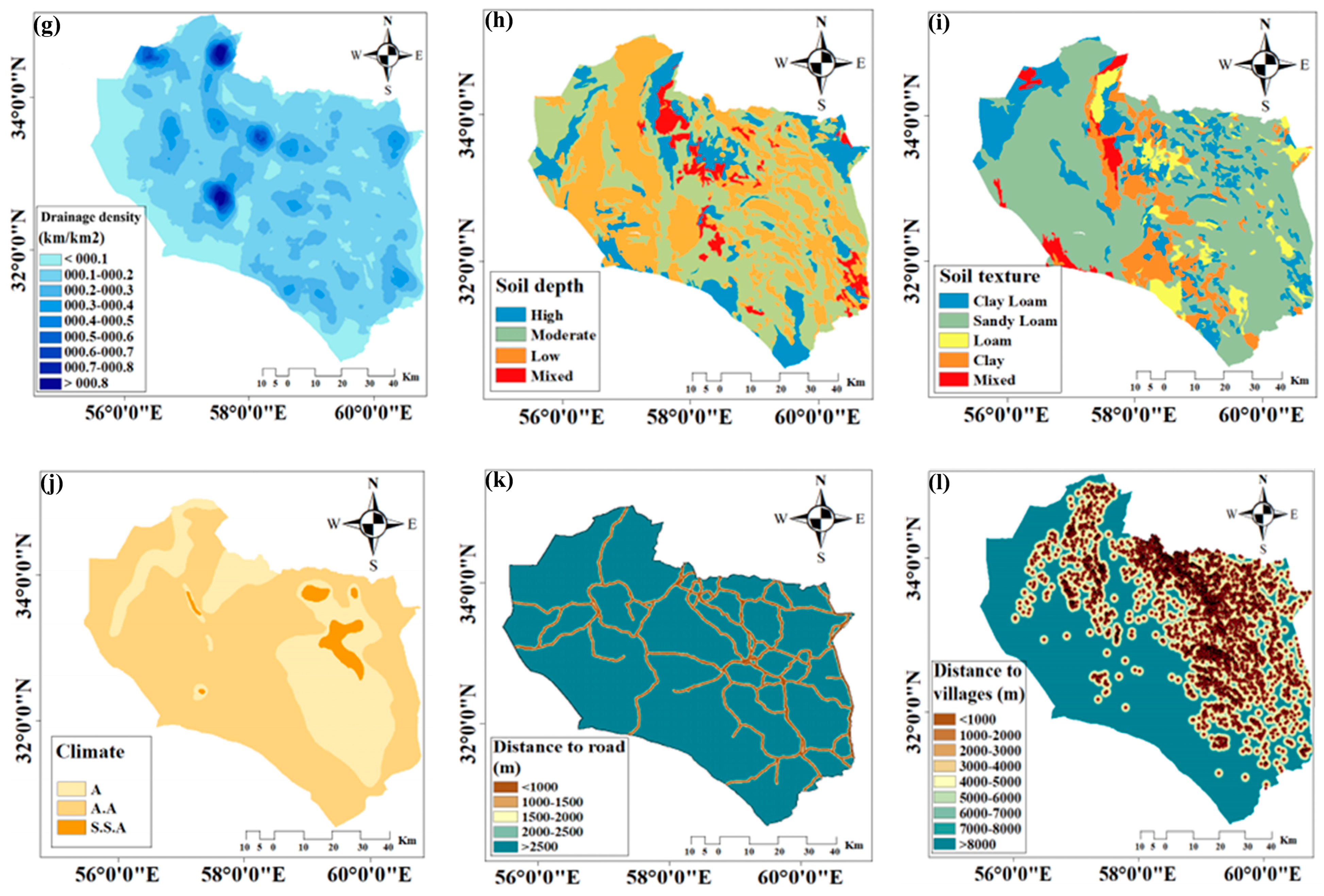
- Drainage Density (DD) Map
- Soil Depth (SD) Map
- Soil Texture (ST) Map
- Climate (CL) Map
- Distance to Roads (DTD) Map
- Distance to Villages (DTV) Map
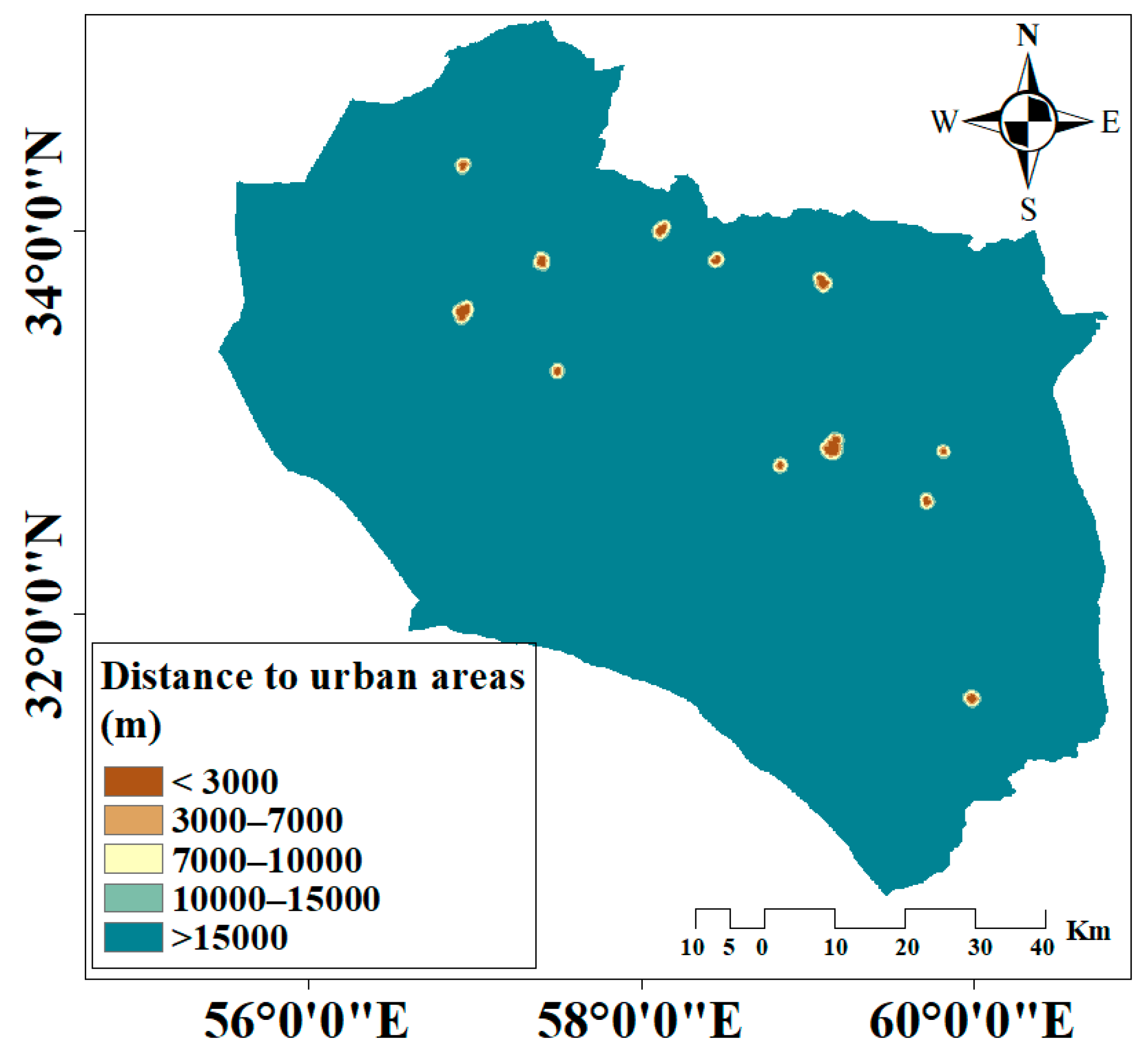
- Distance to Urban Areas (DTU) Map
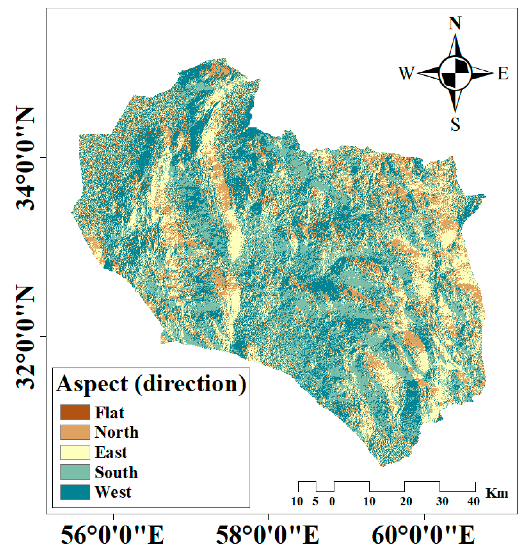
- Aspect (AS) Map
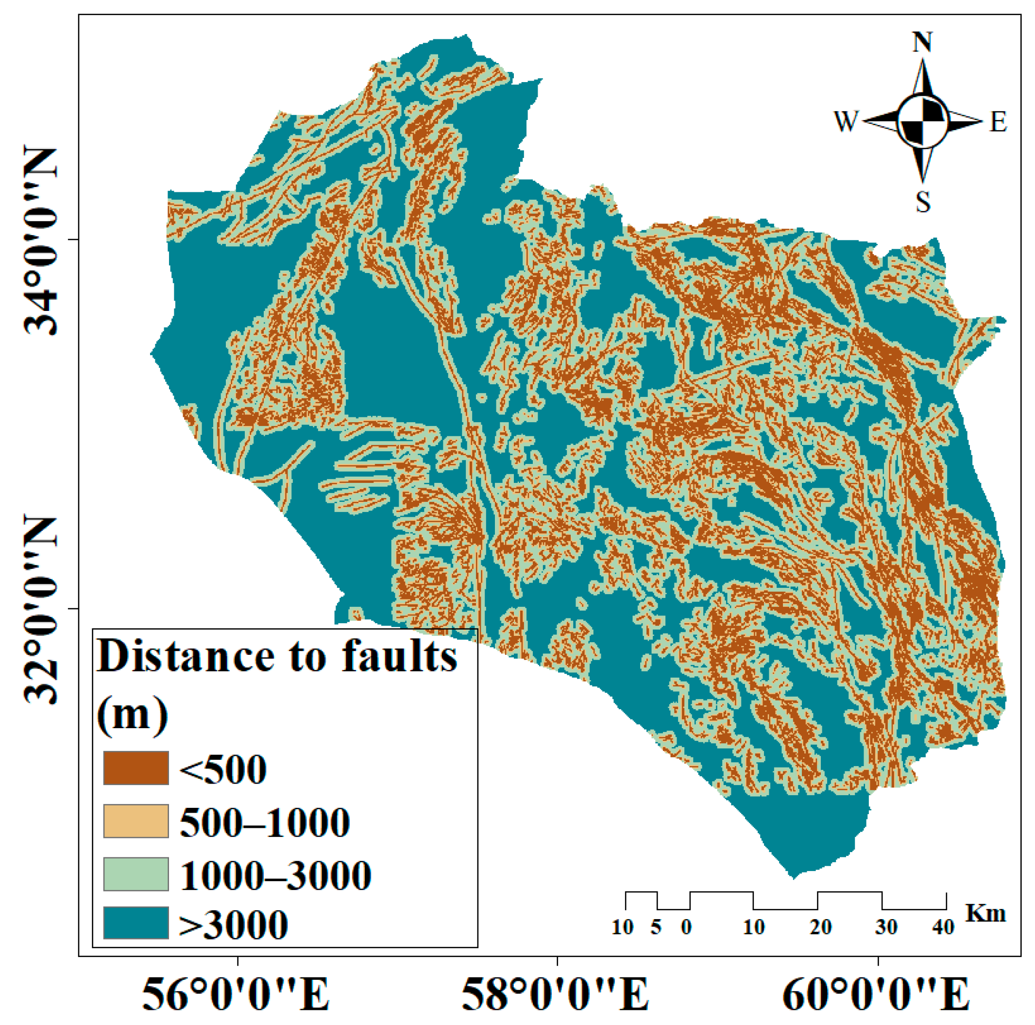
- Distance to Faults (DTF) Map
2.2.3. Normalization of the Maps
2.2.4. Integrated Flood Assessment Approach (IFAA)
- Analytical Hierarchy Process (AHP)-Weighted Linear Combination (WLC) Method
- Fuzzy-Ordered Weighted Averaging (FOWA) Method
- Scenario 1: At Least One (α = 0.0001): The most optimistic scenario, akin to the “OR” operator, assumes high risk with minimal recoverability. It emphasizes the importance of any single criterion;
- Scenario 2: Few (α = 0.1): A slightly less optimistic approach that still introduces high risk with moderate trade-offs;
- Scenario 3: Some (α = 0.5): A balanced scenario that combines higher risks with a greater degree of recoverability, offering a compromise between optimism and trade-offs;
- Scenario 4: Half (α = 1): Represents moderate risk with complete trade-offs, ensuring an equal balance between risk and recoverability;
- Scenario 5: Many (α = 2): A scenario with low risk but some trade-offs, moving toward a more conservative assessment;
- Scenario 6: Most (α = 10): Minimizes risk while allowing for minimal trade-offs;
- Scenario 7: All (α = 1000): The most pessimistic scenario, similar to the “AND” operator, assumes minimal risk and no trade-offs, prioritizing less important criteria equally.
2.2.5. Validation
2.2.6. Sustainability Implications
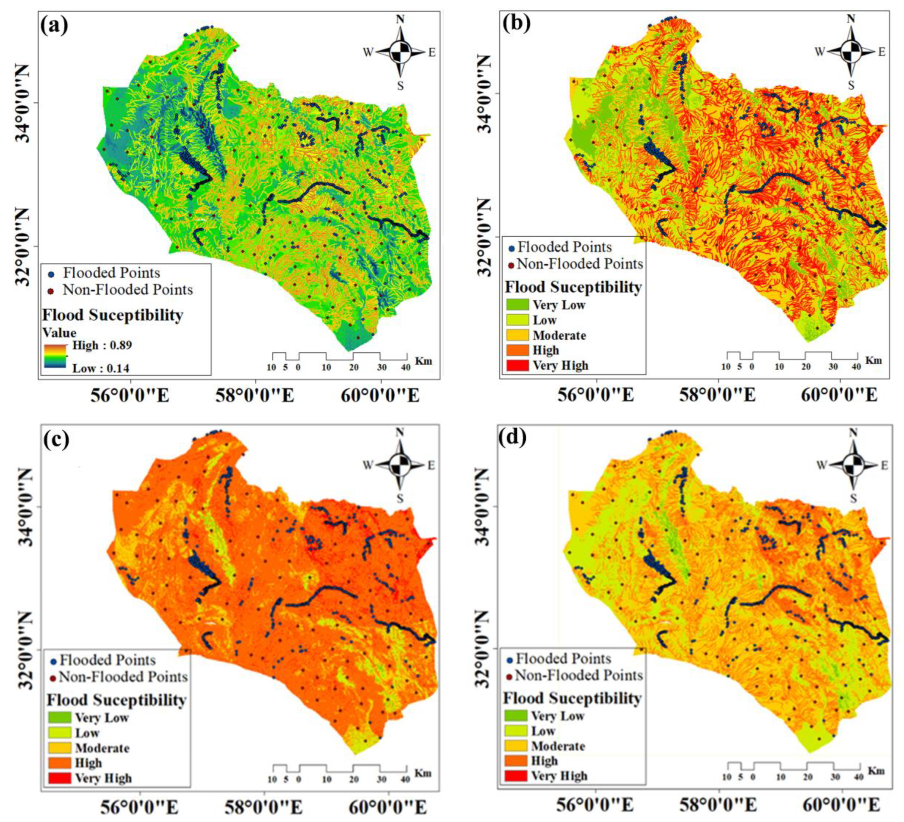
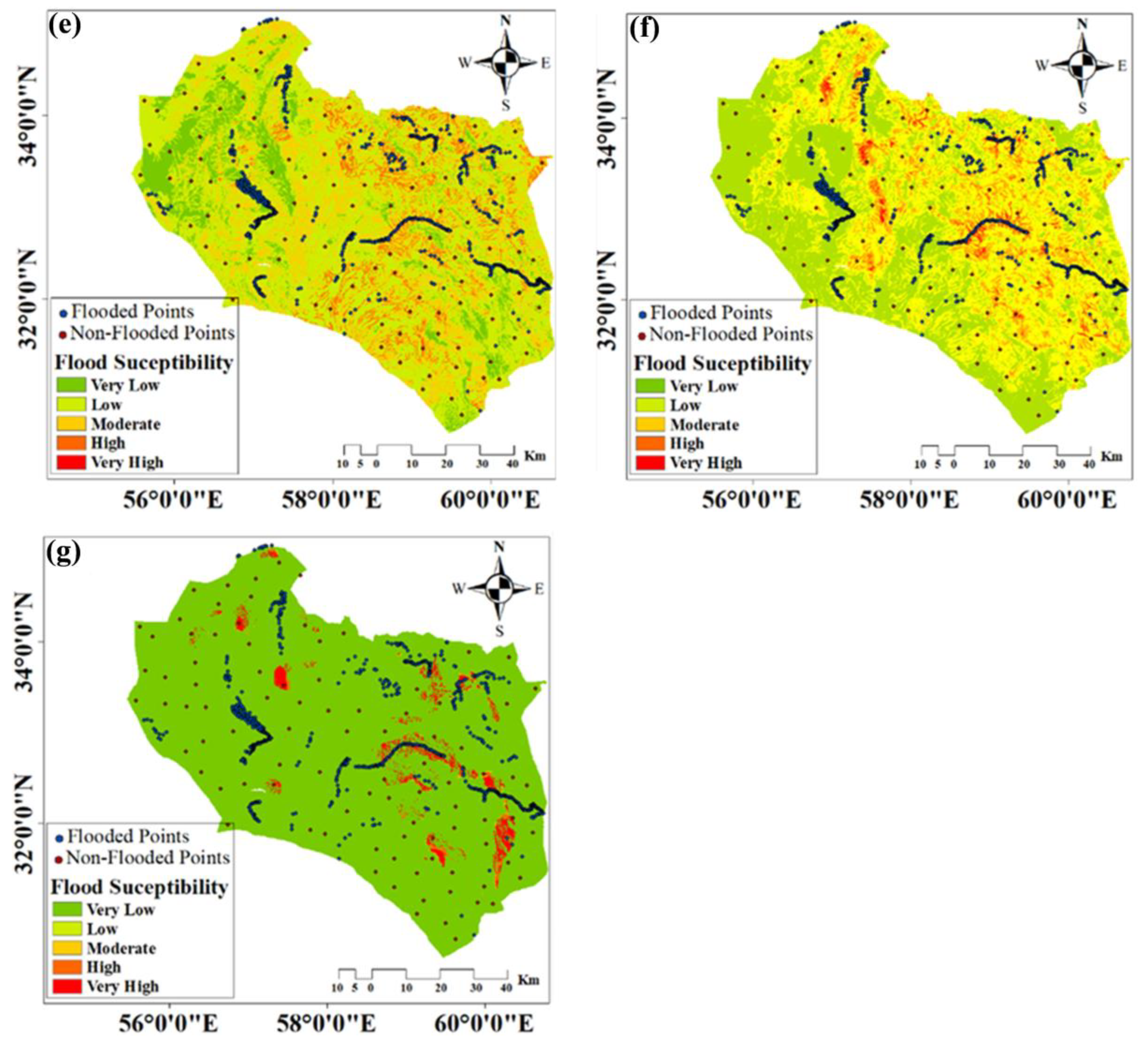
3. Results
3.1. Weight Estimation of the Flood Controlling Factors
3.2. Flood Susceptibility Maps Using the AHP-WLC Method
3.3. Risk Scenarios of Flood Susceptibility Using the FOWA Method
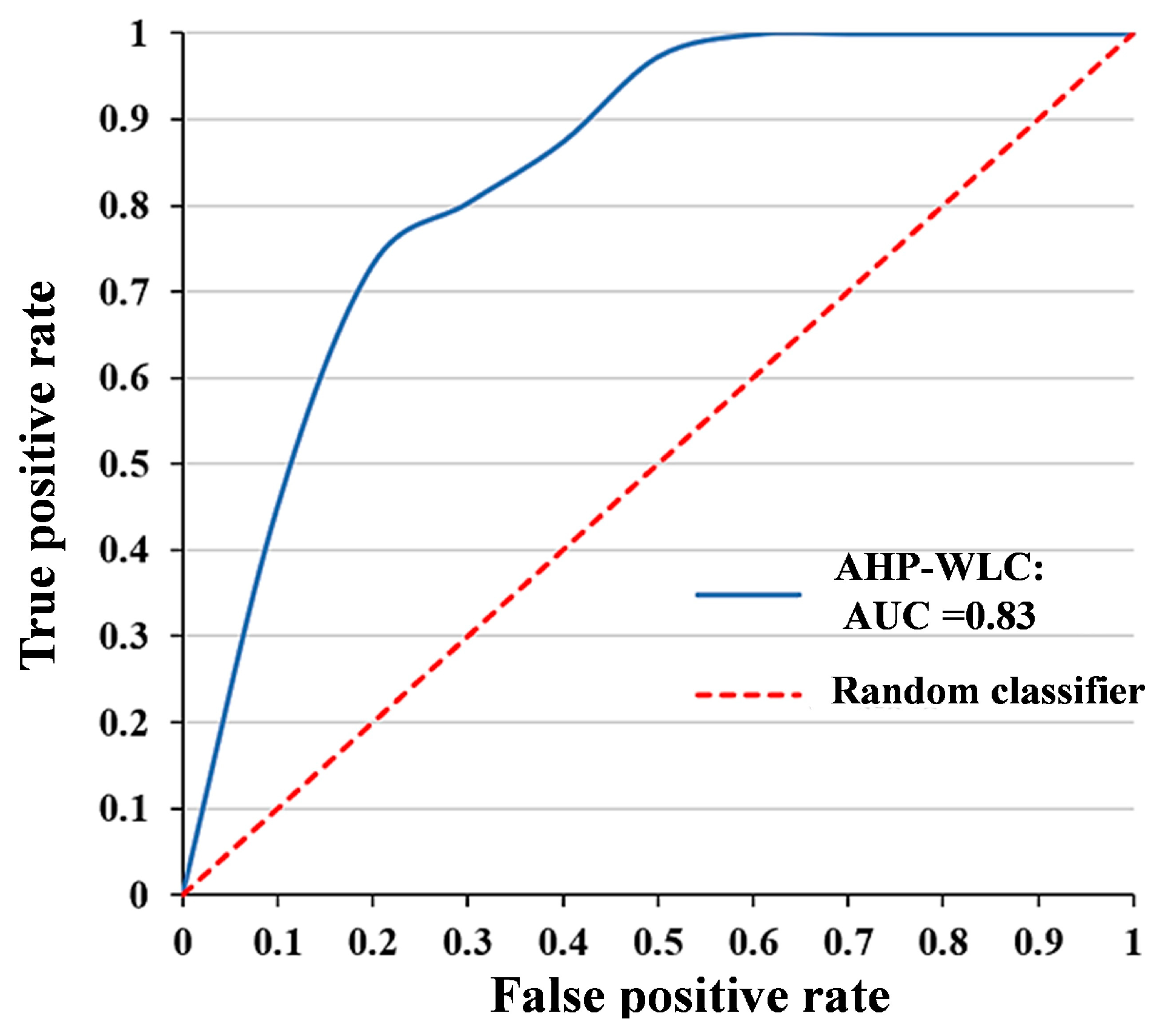
3.4. Accuracy Assessment
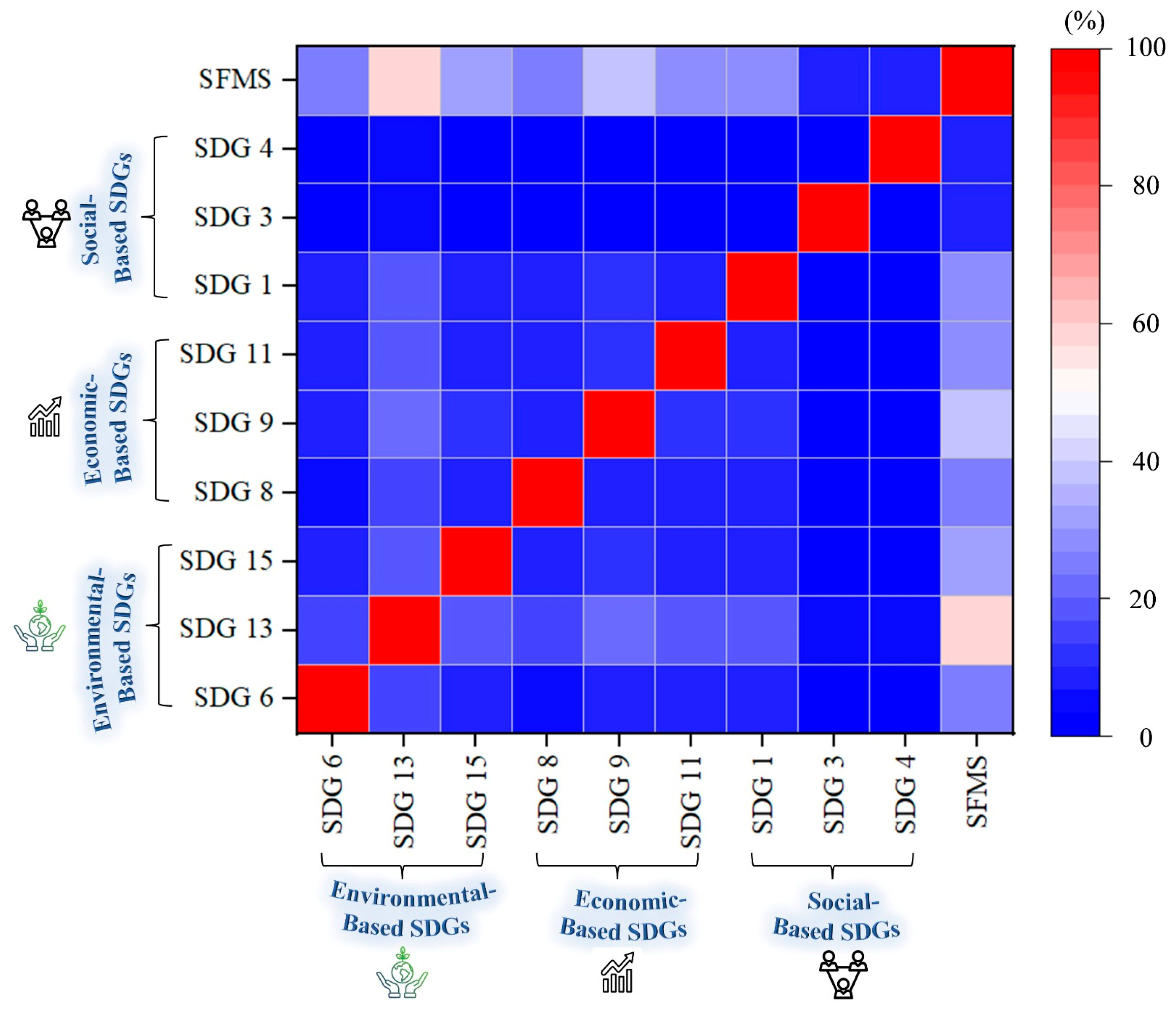
3.5. Impact of the Study Findings on the SDGs
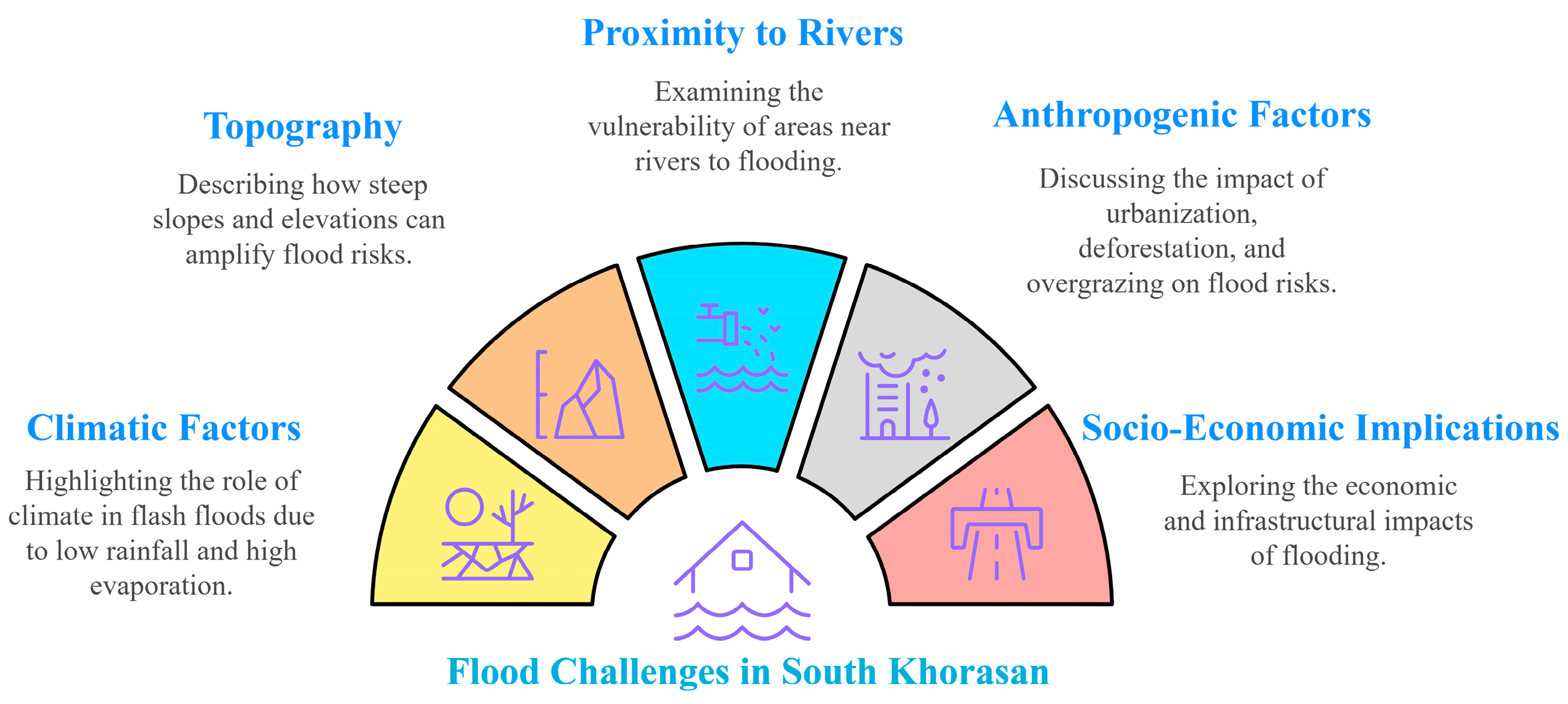
3.5.1. Emerging Challenges
3.5.2. Sustainable Strategies
- Environmental-Based SDGs
- Economic-Based SDGs
- Social-Based SDGs
4. Discussion
4.1. Controlling Factors vs. Flood Risk Degree
4.1.1. Distance to Rivers (DTR)
4.1.2. Rainfall (RF)
4.1.3. Slope (SL)
4.1.4. Land Use/Land Cover (LU/LC)
4.1.5. Normalized Difference Vegetation Index (NDVI)
4.1.6. Elevation (ELE)
4.1.7. Drainage Density (DD)
4.1.8. Soil Depth (SD)
4.1.9. Soil Texture (ST)
4.1.10. Climate (CL)
4.1.11. Distance to Roads (DTD)
4.1.12. Distance to Villages (DTV)
4.1.13. Distance to Urban Areas (DTU)
4.1.14. Aspect (AS)
4.1.15. Distance to Faults (DTF)
4.2. Analysis of the Flood Risk Maps
4.3. Precision Evaluation of the Flood Risk Maps
4.4. Sustainable Pathways for Flood Resilience in Arid Regions
5. Limitation and Future Research
6. Conclusions
Author Contributions
Funding
Data Availability Statement
Acknowledgments
Conflicts of Interest
Appendix A
References
- Chaudhary, M.T.; Piracha, A. Natural Disasters—Origins, Impacts, Management. Encyclopedia 2021, 1, 1101–1131. [Google Scholar] [CrossRef]
- Naceur, A.; Igmoullan, B.; Namous, M. Machine Learning-Based Optimization of Flood Susceptibility Mapping in Semi-Arid Zone. DYSONA-Appl. Sci. 2025, 6, 145–159. [Google Scholar] [CrossRef]
- Parsian, S.; Amani, M.; Moghimi, A.; Ghorbanian, A.; Mahdavi, S. Flood Hazard Mapping Using Fuzzy Logic, Analytical Hierarchy Process, and Multi-Source Geospatial Datasets. Remote Sens. 2021, 13, 4761. [Google Scholar] [CrossRef]
- Akter, T.; Hoque, M.A.A.; Mukul, S.A.; Pradhan, B. Coastal Flood Induced Salinity Intrusion Risk Assessment Using a Spatial Multi-Criteria Approach in the South-Western Bangladesh. Earth Syst. Environ. 2024, 9, 31–49. [Google Scholar] [CrossRef]
- Choubin, B.; Moradi, E.; Golshan, M.; Adamowski, J.; Sajedi-Hosseini, F.; Mosavi, A. An Ensemble Prediction of Flood Susceptibility Using Multivariate Discriminant Analysis, Classification and Regression Trees, and Support Vector Machines. Sci. Total Environ. 2019, 651, 2087–2096. [Google Scholar] [CrossRef]
- Aerts, J.C.J.H. A Review of Cost Estimates for Flood Adaptation. Water 2018, 10, 1646. [Google Scholar] [CrossRef]
- Paudel, G.; Pant, R.R.; Joshi, T.R.; Saqr, A.M.; Ðurin, B.; Cetl, V.; Kamble, P.N.; Bishwakarma, K. Hydrochemical Dynamics and Water Quality Assessment of the Ramsar-Listed Ghodaghodi Lake Complex: Unveiling the Water-Environment Nexus. Water 2024, 16, 3373. [Google Scholar] [CrossRef]
- Saqr, A.M.; Nasr, M.; Fujii, M.; Yoshimura, C.; Ibrahim, M.G. Integrating MODFLOW-USG and Walrus Optimizer for Estimating Sustainable Groundwater Pumping in Arid Regions Subjected to Severe Drawdown. In Groundwater in Developing Countries; Ali, S., Negm, A., Eds.; Springer: Cham, Switzerland, 2025. [Google Scholar] [CrossRef]
- Ślósarczyk, K.; Dąbrowska, D. A closed municipal landfill as a source of emerging contaminants in adjacent groundwater: Pharmaceuticals and personal care products occurrence and environmental risk assessment. J. Hydrol. 2025, 654, 132829. [Google Scholar] [CrossRef]
- Noman, M.; Ullah, I.; Khan, M.A.; Qazi, A.; Farooq, W.; Saqr, A.; Elsheikh, A. Analysis of Overcurrent Protective Relaying as Minimum Adopted Fault Protection for Small-Scale Hydropower Plants. Int. J. Environ. Sci. Technol. 2024, 21, 4457–4470. [Google Scholar] [CrossRef]
- Abdo, H.G.; Darwish, K.S.; Bindajam, A.A.; Niknam, A.; Youssef, Y.M.; Ahmed, M.F.M.; Mallick, J. Detection of Flood Vulnerable Areas in Urban Basins Using Multi-Criteria Analysis and Geospatial Tools: A Case Study from Eastern Mediterranean. Environ. Earth Sci. 2024, 83, 524. [Google Scholar] [CrossRef]
- Timilsina, B.; Kharel, M.; Shrestha, R.; Saqr, A.M.; Pant, R.R. Assessment of Soil Quality along the Elevation Gradient of the Seti River Watershed in Pokhara Metropolitan City, Nepal. Environ. Monit. Assess. 2025, 197, 296. [Google Scholar] [CrossRef]
- Subbarayan, S.; Youssef, Y.M.; Singh, L.; Dąbrowska, D.; Alarifi, N.; Ramsankaran, R.A.A.J.; Visweshwaran, R.; Saqr, A.M. Soil and Water Assessment Tool-Based Prediction of Runoff Under Scenarios of Land Use/Land Cover and Climate Change Across Indian Agro-Climatic Zones: Implications for Sustainable Development Goals. Water 2025, 17, 458. [Google Scholar] [CrossRef]
- Masria, A.; Alshammari, T.O.; Ghareeb, M.; Seif, A.K.; Abd-Elmaboud, M.E.; Ammar, A.I. 2D and 3D Modeling of Resistivity and Chargeability to Identify the Type of Saturated Groundwater for Complex Sedimentary Facies. Hydrology 2024, 11, 120. [Google Scholar] [CrossRef]
- Afonso de Oliveira Serrão, E.; Silva, M.T.; Ferreira, T.R.; Paiva de Ataide, L.C.; Assis dos Santos, C.; Meiguins de Lima, A.M.; de Paulo Rodrigues da Silva, V.; de Assis Salviano de Sousa, F.; Cardoso Gomes, D.J. Impacts of Land Use and Land Cover Changes on Hydrological Processes and Sediment Yield Determined Using the SWAT Model. Int. J. Sediment Res. 2022, 37, 54–69. [Google Scholar] [CrossRef]
- Ali, S.A.; Khatun, R.; Ahmad, A.; Ahmad, S.N. Application of GIS-Based Analytic Hierarchy Process and Frequency Ratio Model to Flood Vulnerable Mapping and Risk Area Estimation at Sundarban Region, India. Model. Earth Syst. Environ. 2019, 5, 1083–1102. [Google Scholar] [CrossRef]
- Hodaei, A.; Feizi, V. Analysis of the Role of Dispersion of Rural Settlements against Natural Hazards in South Khorasan Province. Q. Sci. J. Rescue Relief 2021, 13, 202–213. [Google Scholar] [CrossRef]
- Bahramloo, R.; Wang, J.; Sepehri, M.; Faghfouri, A.; Ghermezcheshmeh, B.; Atapourfard, A.; Talebi, A.; Abbasi, D.; Bazrafshan, E. Novel MCDA Methods for Flood Hazard Mapping: A Case Study in Hamadan, Iran. Stoch. Environ. Res. Risk Assess. 2024, 38, 4863–4881. [Google Scholar] [CrossRef]
- Haseeb, F.; Ali, S.; Ahmed, N.; Alarifi, N.; Youssef, Y.M. Comprehensive Probabilistic Analysis and Practical Implications of Rainfall Distribution in Pakistan. Atmosphere 2025, 16, 122. [Google Scholar] [CrossRef]
- Sanderson, B.M.; Oleson, K.W.; Strand, W.G.; Lehner, F.; O’Neill, B.C. A New Ensemble of GCM Simulations to Assess Avoided Impacts in a Climate Mitigation Scenario. Clim. Change 2018, 146, 303–318. [Google Scholar] [CrossRef]
- Rincón, D.; Khan, U.T.; Armenakis, C. Flood Risk Mapping Using GIS and Multi-Criteria Analysis: A Greater Toronto Area Case Study. Geosciences 2018, 8, 275. [Google Scholar] [CrossRef]
- Lyu, H.M.; Yin, Z.Y.; Zhou, A.; Shen, S.L. MCDM-Based Flood Risk Assessment of Metro Systems in Smart City Development: A Review. Environ. Impact Assess. Rev. 2023, 101, 107154. [Google Scholar] [CrossRef]
- Xiao, Y.; Yi, S.; Tang, Z. Integrated Flood Hazard Assessment Based on Spatial Ordered Weighted Averaging Method Considering Spatial Heterogeneity of Risk Preference. Sci. Total Environ. 2017, 599–600, 1034–1046. [Google Scholar] [CrossRef] [PubMed]
- Ahmadizadeh, S.R.; Karimzadeh Motlagh, Z.; Ashrafi, A. Capability Evaluation of Ecotourism in Birjand County Based on Scenario Design and Fuzzy_Owa Algorithm. Environ. Res. J. 2016, 7, 31–46. [Google Scholar]
- Sathiyamurthi, S.; Youssef, Y.M.; Gobi, R.; Ravi, A.; Alarifi, N.; Sivasakthi, M.; Praveen Kumar, S.; Dąbrowska, D.; Saqr, A.M. Optimal Land Selection for Agricultural Purposes Using Hybrid Geographic Information System–Fuzzy Analytic Hierarchy Process–Geostatistical Approach in Attur Taluk, India: Synergies and Trade-Offs Among Sustainable Development Goals. Sustainability 2025, 17, 809. [Google Scholar] [CrossRef]
- Rafiei-Sardooi, E.; Azareh, A.; Choubin, B.; Mosavi, A.H.; Clague, J.J. Evaluating Urban Flood Risk Using Hybrid Method of TOPSIS and Machine Learning. Int. J. Disaster Risk Reduct. 2021, 66, 102614. [Google Scholar] [CrossRef]
- Wang, Y.; Hong, H.; Chen, W.; Li, S.; Pamučar, D.; Gigović, L.; Drobnjak, S.; Bui, D.T.; Duan, H. A Hybrid GIS Multi-Criteria Decision-Making Method for Flood Susceptibility Mapping at Shangyou, China. Remote Sens. 2019, 11, 62. [Google Scholar] [CrossRef]
- Timalsina, R.; Acharya, S.; Đurin, B.; Awasthi, M.P.; Pant, R.R.; Joshi, G.R.; Byanju, R.M.; Panthi, K.P.; Joshi, S.; Kumar, A.; et al. An Assessment of Seasonal Water Quality in Phewa Lake, Nepal, by Integrating Geochemical Indices and Statistical Techniques: A Sustainable Approach. Water 2025, 17, 238. [Google Scholar] [CrossRef]
- Ghasemkhani, N.; Vayghan, S.S.; Abdollahi, A.; Pradhan, B.; Alamri, A. Urban Development Modeling Using Integrated Fuzzy Systems, Ordered Weighted Averaging (OWA), and Geospatial Techniques. Sustainability 2020, 12, 809. [Google Scholar] [CrossRef]
- Fateminia, S.H.; Nguyen, P.H.D.; Fayek, A.R. An Adaptive Hybrid Model for Determining Subjective Causal Relationships in Fuzzy System Dynamics Models for Analyzing Construction Risks. CivilEng 2021, 2, 747–764. [Google Scholar] [CrossRef]
- Masria, A.; Seif, A.K.; Ghareeb, M.; Abd-Elmaboud, M.E.; Soliman, K.; Ammar, A.I. Numerical Modeling of Vadose Zone Electrical Resistivity to Evaluate Its Hydraulic Parameters. Appl. Water Sci. 2023, 13, 224. [Google Scholar] [CrossRef]
- Tang, Z.; Zhang, H.; Yi, S.; Xiao, Y. Assessment of Flood Susceptible Areas Using Spatially Explicit, Probabilistic Multi-Criteria Decision Analysis. J. Hydrol. 2018, 558, 144–158. [Google Scholar] [CrossRef]
- Saghafi, M. Evaluating and Classifying Restrictions and Hydrogeomorphic Hazards for Sustainable Urban Development Planning in Dry Areas (Case Study: Birjand, South Khorasan Province, Iran). Nat. Hazards 2018, 93, 219–236. [Google Scholar] [CrossRef]
- L3Harris. Available online: https://www.l3harris.com/all-capabilities/satellite-imagery?utm_source=google&utm_medium=cpc&utm_campaign=sas-ss-satellite-imagerysearch&gad_source=1&gclid=cjwkcaiajp-7bhbzeiwamh9rbsbkxngid5y9pcmk26wognarxa_o0kzy01tbursvskqhofljbtxkxocci4qavd_bwe (accessed on 15 February 2023).
- USGS Homepage. Available online: https://earthexplorer.usgs.gov/ (accessed on 25 April 2024).
- Esri. Available online: https://www.esri.com/en-us/arcgis/products/arcgis-location-platform/services/basemaps (accessed on 2 March 2021).
- Sarvestan, R.; Karami, M.; Sabbaghian, R.J. Assessment of the Weather Research and Forecasting Model in Simulation of Rainfall for Khorasan Razavi Province, Iran. Arab. J. Geosci. 2022, 15, 164. [Google Scholar] [CrossRef]
- FAO. Available online: https://wapor.apps.fao.org/catalog/wapor_2/1 (accessed on 15 February 2025).
- Kader, Z.; Islam, M.R.; Aziz, M.T.; Hossain, M.M.; Islam, M.R.; Miah, M.; Jaafar, W.Z.W. GIS and AHP-Based Flood Susceptibility Mapping: A Case Study of Bangladesh. Sustain. Water Resour. Manag. 2024, 10, 170. [Google Scholar] [CrossRef]
- Hassan Sayyari-Zahan, M. Soil Classification and Genesis in Part of Khorasan Province. In Developments in Soil Classification, Land Use Planning and Policy Implications: Innovative Thinking of Soil Inventory for Land Use Planning and Management of Land Resources; Springer: Dordrecht, The Netherlands, 2013; pp. 405–415. [Google Scholar] [CrossRef]
- Shirazi, A.; Hezarkhani, A.; Shirazy, A. Exploration Geochemistry Data-Application for Cu Anomaly Separation Based On Classical and Modern Statistical Methods in South Khorasan, Iran. Int. J. Sci. Eng. Appl. 2018, 7, 039–044. [Google Scholar] [CrossRef]
- Masoudi, M.; Yousefi, M.; Behbahani, N. Hazard Assessment of Climate Changes in South Khorasan Province, Iran. EQA-Int. J. Environ. Qual. 2018, 29, 29–39. [Google Scholar]
- Graf, M.; El Hachem, A.; Eisele, M.; Seidel, J.; Chwala, C.; Kunstmann, H.; Bárdossy, A. Rainfall Estimates from Opportunistic Sensors in Germany across Spatio-Temporal Scales. J. Hydrol. Reg. Stud. 2021, 37, 100883. [Google Scholar] [CrossRef]
- Saqr, A.M.; Nasr, M.; Fujii, M.; Yoshimura, C.; Ibrahim, M.G. Monitoring of Agricultural Expansion Using Hybrid Classification Method in Southwestern Fringes of Wadi El-Natrun, Egypt: An Appraisal for Sustainable Development. In Proceedings of the Asia Conference on Environment and Sustainable Development, Kyoto, Japan, 4–6 November 2023; Ujikawa, K., Ishiwatari, M., Hullebusch, E.V., Eds.; Springer: Singapore, 2023; pp. 349–362. [Google Scholar] [CrossRef]
- Shafizadeh-Moghadam, H.; Valavi, R.; Shahabi, H.; Chapi, K.; Shirzadi, A. Novel Forecasting Approaches Using Combination of Machine Learning and Statistical Models for Flood Susceptibility Mapping. J. Environ. Manag. 2018, 217, 1–11. [Google Scholar] [CrossRef]
- Lin, P.; Pan, M.; Wood, E.F.; Yamazaki, D.; Allen, G.H. A New Vector-Based Global River Network Dataset Accounting for Variable Drainage Density. Sci. Data 2021, 8, 28. [Google Scholar] [CrossRef] [PubMed]
- Chen, S.; Arrouays, D.; Mulder, V.L.; Poggio, L.; Minasny, B.; Roudier, P.; Libohova, Z.; Lagacherie, P.; Shi, Z.; Hannam, J.; et al. Digital Mapping of GlobalSoilMap Soil Properties at a Broad Scale: A Review. Geoderma 2022, 409, 115567. [Google Scholar] [CrossRef]
- Sepehri, M.; Malekinezhad, H.; Jahanbakhshi, F.; Ildoromi, A.R.; Chezgi, J.; Ghorbanzadeh, O.; Naghipour, E. Integration of Interval Rough AHP and Fuzzy Logic for Assessment of Flood Prone Areas at the Regional Scale. Acta Geophys. 2020, 68, 477–493. [Google Scholar] [CrossRef]
- Chamani, R.; Sadeghi, S.H.; Zare, S.; Shekohideh, H.; Mumzaei, A.; Amini, H.; Hemmati, L.; Zarei, R. Flood-Oriented Watershed Health and Ecological Security Conceptual Modeling Using Pressure, State, and Response (PSR) Approach for the Sharghonj Watershed, South Khorasan Province, Iran. Nat. Resour. Model. 2024, 37, e12385. [Google Scholar] [CrossRef]
- Mehrabi, M.; Moayedi, H. Landslide Susceptibility Mapping Using Artificial Neural Network Tuned by Metaheuristic Algorithms. Environ. Earth Sci. 2021, 80, 804. [Google Scholar] [CrossRef]
- Jamshed, A.; Birkmann, J.; Ahmad Rana, I.; Feldmeyer, D. The Effect of Spatial Proximity to Cities on Rural Vulnerability against Flooding: An Indicator Based Approach. Ecol. Indic. 2020, 118, 106704. [Google Scholar] [CrossRef]
- Dodangeh, E.; Choubin, B.; Eigdir, A.N.; Nabipour, N.; Panahi, M.; Shamshirband, S.; Mosavi, A. Integrated Machine Learning Methods with Resampling Algorithms for Flood Susceptibility Prediction. Sci. Total Environ. 2020, 705, 135983. [Google Scholar] [CrossRef]
- Aly, M.H.; Giardino, J.R.; Klein, A.G. Suitability Assessment for New Minia City, Egypt: A GIS Approach to Engineering Geology. Environ. Eng. Geosci. 2005, 11, 259–269. [Google Scholar] [CrossRef]
- Wani, M.A.; Shaista, N.; Wani, Z.M. Spatial Variability of Some Chemical and Physical Soil Properties in Bandipora District of Lesser Himalayas. J. Indian Soc. Remote Sens. 2017, 45, 611–620. [Google Scholar] [CrossRef]
- Saaty, T. The Analytic Hierarchy Process; McGraw Hill: New York, NY, USA, 1980. [Google Scholar]
- Arefin, R.; Rahman, A.T.M.S.; Das, J.; Jahan, C.S.; Mazumder, Q.H.; Gomaa, E.; Abd El Aal, A.K.; Radwan, A.E.; Youssef, Y.M. Megacity solid waste disposal suitability mapping in Dhaka, Bangladesh: An integrated approach using remote sensing, GIS and statistics. Environ Monit Assess. 2024, 196, 910. [Google Scholar] [CrossRef] [PubMed]
- Yin, S.; Li, J.; Liang, J.; Jia, K.; Yang, Z.; Wang, Y. Optimization of the Weighted Linear Combination Method for Agricultural Land Suitability Evaluation Considering Current Land Use and Regional Differences. Sustainability 2020, 12, 10134. [Google Scholar] [CrossRef]
- Goffi, A.; Stroppiana, D.; Brivio, P.A.; Bordogna, G.; Boschetti, M. Towards an Automated Approach to Map Flooded Areas from Sentinel-2 MSI Data and Soft Integration of Water Spectral Features. Int. J. Appl. Earth Obs. Geoinf. 2020, 84, 101951. [Google Scholar] [CrossRef]
- Yager, R.R. On Ordered Weighted Averaging Aggregation Operators in Multicriteria Decisionmaking. IEEE Trans. Syst. Man Cybern. 1988, 18, 183–190. [Google Scholar] [CrossRef]
- Motlagh, Z.K.; Sayadi, M.H. Siting MSW Landfills Using MCE Methodology in GIS Environment (Case Study: Birjand Plain, Iran). Waste Manag. 2015, 46, 322–337. [Google Scholar] [CrossRef]
- Gholami, F.; Li, Y.; Zhang, J.; Nemati, A. Quantitative Assessment of Future Environmental Changes in Hydrological Risk Components: Integration of Remote Sensing, Machine Learning, and Hydraulic Modeling. Water 2024, 16, 3354. [Google Scholar] [CrossRef]
- Jaskowiak, P.A.; Costa, I.G.; Campello, R.J.G.B. The Area under the ROC Curve as a Measure of Clustering Quality. Data Min. Knowl. Discov. 2022, 36, 1219–1245. [Google Scholar] [CrossRef]
- Souissi, D.; Souie, A.; Sebei, A.; Mahfoudhi, R.; Zghibi, A.; Zouhri, L.; Amiri, W.; Ghanmi, M. Flood Hazard Mapping and Assessment Using Fuzzy Analytic Hierarchy Process and GIS Techniques in Takelsa, Northeast Tunisia. Arab. J. Geosci. 2022, 15, 1405. [Google Scholar] [CrossRef]
- Mokhtari, E.; Mezali, F.; Abdelkebir, B.; Engel, B. Flood Risk Assessment Using Analytical Hierarchy Process: A Case Study from the Cheliff-Ghrib Watershed, Algeria. J. Water Clim. Change 2023, 14, 694–711. [Google Scholar] [CrossRef]
- Mohseni, U.; Agnihotri, P.G.; Pande, C.B.; Durin, B. Understanding the Climate Change and Land Use Impact on Streamflow in the Present and Future under CMIP6 Climate Scenarios for the Parvara Mula Basin, India. Water 2023, 15, 1753. [Google Scholar] [CrossRef]
- Mohseni, U.; Jat, P.K.; Siriteja, V. Multi-criteria analysis-based mapping of the cyclone-induced pluvial flooding in coastal areas of India. DYSONA-Appl. Sci. 2025, 6, 309–321. [Google Scholar] [CrossRef]
- Bashir, B.; Alsalman, A. Morpho-Hydrological Analysis and Preliminary Flash Flood Hazard Mapping of Neom City, Northwestern Saudi Arabia, Using Geospatial Techniques. Sustainability 2024, 16, 23. [Google Scholar] [CrossRef]
- Hasnaoui, Y.; Tachi, S.E.; Bouguerra, H.; Benmamar, S.; Gilja, G.; Szczepanek, R.; Navarro-Pedreño, J.; Yaseen, Z.M. Enhanced Machine Learning Models Development for Flash Flood Mapping Using Geospatial Data. Euro-Mediterr. J. Environ. Integr. 2024, 9, 1087–1107. [Google Scholar] [CrossRef]
- Cui, Y.; Yang, L.; Xu, C.; Zheng, J. Spatial Distribution of Shallow Landslides Caused by Typhoon Lekima in 2019 in Zhejiang Province, China. J. Mt. Sci. 2024, 21, 1564–1580. [Google Scholar] [CrossRef]
- Nguyen, H.D.; Nguyen, Q.H.; Dang, D.K.; Van, C.P.; Truong, Q.H.; Pham, S.D.; Bui, Q.T.; Petrisor, A.I. A Novel Flood Risk Management Approach Based on Future Climate and Land Use Change Scenarios. Sci. Total Environ. 2024, 921, 171204. [Google Scholar] [CrossRef]
- Huang, X.; Shen, J.; Li, S.; Chi, C.; Guo, P.; Hu, P. Sustainable Flood Control Strategies under Extreme Rainfall: Allocation of Flood Drainage Rights in the Middle and Lower Reaches of the Yellow River Based on a New Decision-Making Framework. J. Environ. Manag. 2024, 367, 122020. [Google Scholar] [CrossRef] [PubMed]
- Nkwunonwo, U.C.; Whitworth, M.; Baily, B. A Review of the Current Status of Flood Modelling for Urban Flood Risk Management in the Developing Countries. Sci. Afr. 2020, 7, e00269. [Google Scholar] [CrossRef]
- Mudashiru, R.B.; Sabtu, N.; Abustan, I.; Balogun, W. Flood Hazard Mapping Methods: A Review. J. Hydrol. 2021, 603, 126846. [Google Scholar] [CrossRef]
- Zabihi, O.; Siamaki, M.; Gheibi, M.; Akrami, M.; Hajiaghaei-Keshteli, M. A Smart Sustainable System for Flood Damage Management with the Application of Artificial Intelligence and Multi-Criteria Decision-Making Computations. Int. J. Disaster Risk Reduct. 2023, 84, 103470. [Google Scholar] [CrossRef]
- Majid, S.I.; Kumar, M.; Sahu, N.; Kumar, P.; Tripathi, D.K. Application of Ensemble Fuzzy Weights of Evidence-Support Vector Machine (Fuzzy WofE-SVM) for Urban Flood Modeling and Coupled Risk (CR) Index for Ward Prioritization in NCT Delhi, India. Environ. Dev. Sustain. 2024, 1–39. [Google Scholar] [CrossRef]
- Fraehr, N.; Wang, Q.J.; Wu, W.; Nathan, R. Assessment of Surrogate Models for Flood Inundation: The Physics-Guided LSG Model vs. State-of-the-Art Machine Learning Models. Water Res. 2024, 252, 121202. [Google Scholar] [CrossRef]
- Kolukula, S.S.; Murty, P.L.N. Enhancing Observations Data: A Machine-Learning Approach to Fill Gaps in the Moored Buoy Data. Results Eng. 2025, 26, 104708. [Google Scholar] [CrossRef]
- Yilmaz, M.U. Enhancing Sustainable Flood Risk Management Through a Novel Fuzzy Multi-Stakeholder Framework: Enhancing Sustainable Flood Risk Management through a Novel Fuzzy Multi-Stakeholder Framework: M. U. Yilmaz. Water Resour. Manag. 2024, 39, 1453–1480. [Google Scholar] [CrossRef]
- Hoang, D.V.; Liou, Y.A. Assessing the Influence of Human Activities on Flash Flood Susceptibility in Mountainous Regions of Vietnam. Ecol. Indic. 2024, 158, 111417. [Google Scholar] [CrossRef]
- Ahmed, I.; Das (Pan), N.; Debnath, J.; Bhowmik, M.; Bhattacharjee, S. Flood Hazard Zonation Using GIS-Based Multi-Parametric Analytical Hierarchy Process. Geosyst. Geoenviron. 2024, 3, 100250. [Google Scholar] [CrossRef]
- Banjara, M.; Bhusal, A.; Ghimire, A.B.; Kalra, A. Impact of Land Use and Land Cover Change on Hydrological Processes in Urban Watersheds: Analysis and Forecasting for Flood Risk Management. Geosciences 2024, 14, 40. [Google Scholar] [CrossRef]
- Ermagun, A.; Smith, V.; Janatabadi, F. High Urban Flood Risk and No Shelter Access Disproportionally Impacts Vulnerable Communities in the USA. Commun. Earth Environ. 2024, 5, 2. [Google Scholar] [CrossRef]
- Saqr, A.M.; Nasr, M.; Fujii, M.; Yoshimura, C.; Ibrahim, M.G. Optimal Solution for Increasing Groundwater Pumping by Integrating MODFLOW-USG and Particle Swarm Optimization Algorithm: A Case Study of Wadi El-Natrun, Egypt. In Proceedings of the International Conference on Environment Science and Engineering, ICESE 2022, Beijing, China, 2–5 September 2022; Chen, X., Ed.; Springer: Singapore, 2023; pp. 59–73. [Google Scholar] [CrossRef]
- Agache, I.; Sampath, V.; Aguilera, J.; Akdis, C.A.; Akdis, M.; Barry, M.; Bouagnon, A.; Chinthrajah, S.; Collins, W.; Dulitzki, C.; et al. Climate Change and Global Health: A Call to More Research and More Action. Allergy Eur. J. Allergy Clin. Immunol. 2022, 77, 1389–1407. [Google Scholar] [CrossRef] [PubMed]
- Udo, F.; Bhanye, J.; Daoudiallo, B.; Naidu, M. Evaluating the Sustainability of Local Women’s Climate Change Adaptation Strategies in Durban, South Africa: A Feminist Political Ecology and Intersectionality Perspective. Sustain. Dev. 2024, 1–16. [Google Scholar] [CrossRef]
- Bhowmik, D.; Kader, Z.; Hosen, B.; Hossain, S. Exploring socioeconomic vulnerability and natural disasters impacts on water access in Southwestern Bangladesh. DYSONA-Appl. Sci. 2025, 6, 186–199. [Google Scholar] [CrossRef]
- Mohajervatan, A.; Tavakoli, N.; Khankeh, H.; Raeisi, A.R.; Atighechian, G. Identifying Flood Response Experiences in Iranian Health System: A Qualitative Study. J. Flood Risk Manag. 2023, 16, e12932. [Google Scholar] [CrossRef]
- Mutch, C. The Role of Schools in Disaster Preparedness, Response and Recovery: What Can We Learn from the Literature? Pastor. Care Educ. 2014, 32, 5–22. [Google Scholar] [CrossRef]
- Moser, C.S. Communicating Climate Change: History, Challenges, Process and Future Directions. Wiley Interdiscip. Rev. Clim. Change 2010, 1, 31–53. [Google Scholar] [CrossRef]
- Mumtaz, M.; Jahanzaib, S.H.; Hussain, W.; Khan, S.; Youssef, Y.M.; Qaysi, S.; Abdelnabi, A.; Alarifi, N.; Abd-Elmaboud, M.E. Synergy of Remote Sensing and Geospatial Technologies to Advance Sustainable Development Goals for Future Coastal Urbanization and Environmental Challenges in a Riverine Megacity. ISPRS Int. J. Geo-Inf. 2025, 14, 30. [Google Scholar] [CrossRef]


| Factor | DTR | RF | SL | LU/LC | NDVI | ELE | DD | SD | ST | CL | DTD | DTV | DTU | AS | DTF |
|---|---|---|---|---|---|---|---|---|---|---|---|---|---|---|---|
| DTR | 1 | 2 | 3 | 4 | 5 | 6 | 6 | 7 | 7 | 8 | 8 | 8 | 9 | 9 | 9 |
| RF | 0.5 | 1 | 2 | 3 | 4 | 5 | 6 | 6 | 7 | 7 | 8 | 8 | 8 | 9 | 9 |
| SL | 0.33 | 0.50 | 1 | 2 | 3 | 4 | 5 | 6 | 6 | 7 | 7 | 8 | 8 | 8 | 9 |
| LU/LC | 0.25 | 0.33 | 0.50 | 1 | 2 | 3 | 4 | 5 | 6 | 6 | 7 | 7 | 8 | 8 | 8 |
| NDVI | 0.20 | 0.25 | 0.33 | 0.50 | 1 | 2 | 3 | 4 | 5 | 6 | 6 | 7 | 7 | 8 | 8 |
| ELE | 0.17 | 0.20 | 0.25 | 0.33 | 0.50 | 1 | 2 | 3 | 4 | 5 | 6 | 6 | 7 | 7 | 8 |
| DD | 0.17 | 0.17 | 0.20 | 0.25 | 0.33 | 0.50 | 1 | 2 | 3 | 4 | 5 | 6 | 6 | 7 | 7 |
| SD | 0.14 | 0.17 | 0.17 | 0.20 | 0.25 | 0.33 | 0.5 | 1 | 2 | 3 | 4 | 5 | 6 | 6 | 7 |
| ST | 0.14 | 0.14 | 0.17 | 0.17 | 0.20 | 0.25 | 0.3333 | 0.5 | 1 | 2 | 3 | 4 | 5 | 6 | 6 |
| CL | 0.13 | 0.14 | 0.14 | 0.17 | 0.17 | 0.20 | 0.25 | 0.33 | 0.5 | 1 | 2 | 3 | 4 | 5 | 6 |
| DTD | 0.13 | 0.13 | 0.14 | 0.14 | 0.17 | 0.17 | 0.20 | 0.25 | 0.33 | 0.5 | 1 | 2 | 3 | 4 | 5 |
| DTV | 0.13 | 0.13 | 0.13 | 0.14 | 0.14 | 0.17 | 0.17 | 0.20 | 0.25 | 0.33 | 0.5 | 1 | 2 | 3 | 4 |
| DTU | 0.11 | 0.13 | 0.13 | 0.13 | 0.14 | 0.14 | 0.17 | 0.17 | 0.20 | 0.25 | 0.3333 | 0.5 | 1 | 2 | 3 |
| AS | 0.11 | 0.11 | 0.13 | 0.13 | 0.13 | 0.14 | 0.14 | 0.17 | 0.17 | 0.20 | 0.25 | 0.3333 | 0.5 | 1 | 2 |
| DTF | 0.11 | 0.11 | 0.11 | 0.13 | 0.13 | 0.13 | 0.14 | 0.14 | 0.17 | 0.17 | 0.20 | 0.25 | 0.33 | 0.5 | 1 |
| n | 1 | 2 | 3 | 4 | 5 | 6 | 7 | 8 | 9 | 10 | 11 | 12 | 13 | 14 | 15 |
|---|---|---|---|---|---|---|---|---|---|---|---|---|---|---|---|
| RI | 0 | 0 | 0.58 | 0.90 | 1.12 | 1.24 | 1.32 | 1.41 | 1.45 | 1.49 | 1.51 | 1.48 | 1.56 | 1.57 | 1.59 |
| α | 0.0001 | 0.1 | 0.5 | 1 | 2 | 10 | 1000 |
|---|---|---|---|---|---|---|---|
| Decision Strategy | Scenario 1: Maximum level of risk (No trade-off) | Scenario 2: High level of risk (Some trade-off) | Scenario 3: High level of risk (Some trade-off) | Scenario 4: Average level of risk (Full trade-off) | Scenario 5: Low level of risk (Some trade-off) | Scenario 6: Low level of risk (Some trade-off) | Scenario 7: Minimum level of risk (No trade-off) |
| Order weights | |||||||
| DTR | 0.000 | 0.001 | 0.004 | 0.008 | 0.016 | 0.145 | 1 |
| RF | 0.000 | 0 | 0.004 | 0.009 | 0.018 | 0.139 | 0 |
| SL | 0.000 | 0.001 | 0.005 | 0.011 | 0.021 | 0.135 | 0 |
| LU/LC | 0.000 | 0 | 0.007 | 0.015 | 0.029 | 0.147 | 0 |
| NDVI | 0.000 | 0 | 0.009 | 0.019 | 0.036 | 0.133 | 0 |
| ELE | 0.000 | 0.001 | 0.01 | 0.021 | 0.039 | 0.098 | 0 |
| DD | 0.000 | 0.001 | 0.014 | 0.027 | 0.049 | 0.077 | 0 |
| SD | 0.000 | 0.002 | 0.019 | 0.036 | 0.062 | 0.052 | 0 |
| ST | 0.000 | 0.002 | 0.026 | 0.049 | 0.081 | 0.028 | 0 |
| CL | 0.000 | 0.004 | 0.038 | 0.067 | 0.103 | 0.01 | 0 |
| DTR | 0.000 | 0 | 0.051 | 0.086 | 0.12 | 0.002 | 0 |
| DTV | 0.000 | 0.009 | 0.072 | 0.111 | 0.132 | 0.001 | 0 |
| DTU | 0.000 | 0.014 | 0.1 | 0.138 | 0.13 | 0 | 0 |
| AS | 0.000 | 0.028 | 0.163 | 0.18 | 0.113 | 0 | 0 |
| DTF | 1.000 | 0.927 | 0.47 | 0.221 | 0.048 | 0 | 0 |
| ∑ | 1.000 | 1 | 1 | 1 | 1 | 1 | 1 |
| Factor | Overlay Weight | ||
|---|---|---|---|
| South Khorasan Province, Iran | Takelsa, Northeast Tunisia | Cheliff-Ghrib Watershed, Algeria | |
| DTR | 0.221 | 0.160 | - |
| RF | 0.180 | 0.180 | 0.030 |
| SL | 0.139 | 0.210 | 0.220 |
| LU/LC | 0.111 | 0.100 | - |
| NDVI | 0.086 | - | 0.020 |
| ELE | 0.067 | - | 0.320 |
| DD | 0.049 | 0.140 | 0.130 |
| SD | 0.036 | - | - |
| ST | 0.027 | 0.090 | - |
| CL | 0.021 | - | - |
| DTD | 0.019 | - | - |
| DTV | 0.015 | - | - |
| DTU | 0.012 | - | - |
| AS | 0.009 | - | - |
| DTF | 0.008 | - | - |
| TWI | - | 0.012 | 0.08 |
| MNWI | - | - | 0.05 |
| LI | - | - | 0.02 |
| Reference | Current study | [63] | [64] |
| Method | Area of Class (%) | |||||
|---|---|---|---|---|---|---|
| Very Low | Low | Moderate | High | Ver High | ||
| AHP-WLC | 10.23 | 23.14 | 29.61 | 17.54 | 19.48 | |
| FOWA | First scenario | 0.03 | 0.08 | 0.63 | 0.46 | 98.80 |
| Second scenario | 41.45 | 0.09 | 0.61 | 8.49 | 49.36 | |
| Third scenario | 0.20 | 4.49 | 11.14 | 77.62 | 6.55 | |
| Fourth scenario | 1.09 | 21.73 | 48.52 | 28.05 | 0.61 | |
| Fifth scenario | 12.32 | 58.41 | 23.46 | 5.81 | 0.00 | |
| Sixth scenario | 41.97 | 45.55 | 10.31 | 1.89 | 0.28 | |
| Seventh scenario | 96.74 | 0.12 | 0.10 | 0.47 | 2.57 | |
| Scenario | 1 | 2 | 3 | 4 | 5 | 6 | 7 |
|---|---|---|---|---|---|---|---|
| OA (%) | 69.78 | 63.72 | 72.31 | 87 | 78.77 | 69.59 | 66.6 |
Disclaimer/Publisher’s Note: The statements, opinions and data contained in all publications are solely those of the individual author(s) and contributor(s) and not of MDPI and/or the editor(s). MDPI and/or the editor(s) disclaim responsibility for any injury to people or property resulting from any ideas, methods, instructions or products referred to in the content. |
© 2025 by the authors. Licensee MDPI, Basel, Switzerland. This article is an open access article distributed under the terms and conditions of the Creative Commons Attribution (CC BY) license (https://creativecommons.org/licenses/by/4.0/).
Share and Cite
Tavakoli, M.; Motlagh, Z.K.; Dąbrowska, D.; Youssef, Y.M.; Đurin, B.; Saqr, A.M. Harnessing AHP and Fuzzy Scenarios for Resilient Flood Management in Arid Environments: Challenges and Pathways Toward Sustainability. Water 2025, 17, 1276. https://doi.org/10.3390/w17091276
Tavakoli M, Motlagh ZK, Dąbrowska D, Youssef YM, Đurin B, Saqr AM. Harnessing AHP and Fuzzy Scenarios for Resilient Flood Management in Arid Environments: Challenges and Pathways Toward Sustainability. Water. 2025; 17(9):1276. https://doi.org/10.3390/w17091276
Chicago/Turabian StyleTavakoli, Mortaza, Zeynab Karimzadeh Motlagh, Dominika Dąbrowska, Youssef M. Youssef, Bojan Đurin, and Ahmed M. Saqr. 2025. "Harnessing AHP and Fuzzy Scenarios for Resilient Flood Management in Arid Environments: Challenges and Pathways Toward Sustainability" Water 17, no. 9: 1276. https://doi.org/10.3390/w17091276
APA StyleTavakoli, M., Motlagh, Z. K., Dąbrowska, D., Youssef, Y. M., Đurin, B., & Saqr, A. M. (2025). Harnessing AHP and Fuzzy Scenarios for Resilient Flood Management in Arid Environments: Challenges and Pathways Toward Sustainability. Water, 17(9), 1276. https://doi.org/10.3390/w17091276