Article

Integrated Assessment of Groundwater Quality for Water-Saving Irrigation Technology (Western Kazakhstan)

1
Ahmedsafin Institute of Hydrogeology and Environmental Geoscience LLP, Satbayev University, Almaty 050000, Kazakhstan
2
Department of Chemical Engineering, Ariel University, Ariel 40700, Israel
3
Department of Chemical Engineering and Materials & Biotechnology, Ariel University, Ariel 40700, Israel
4
Department of Environmental Research, Eastern R&D Center, Ariel 40700, Israel
5
Renewable Energy and Energy Efficiency Group, Department of Infrastructure Engineering, Melbourne School of Engineering, The University of Melbourne, Parkville, VIC 3010, Australia
*
Author to whom correspondence should be addressed.
Water 2025, 17(8), 1232; https://doi.org/10.3390/w17081232
Submission received: 8 March 2025 / Revised: 9 April 2025 / Accepted: 16 April 2025 / Published: 21 April 2025
(This article belongs to the Special Issue Study of the Soil Water Movement in Irrigated Agriculture III)

Abstract

:
Western Kazakhstan is susceptible to desertification, with surface water resource scarcity constraining agricultural development. Groundwater has substantial potential as a reliable and secure alternative to other water resources, particularly for irrigation, which is required to ensure food security. Eight aquifer segments with an exploitable potential of 0.24 km3/year have been identified for the integrated assessment of groundwater’s suitability for irrigation. The assessment criteria included hydro-chemical groundwater characteristics and irrigated land soil-reclamation conditions. The primary objectives of this study were to assess the groundwater quality for irrigation and to develop a practical operation scheme for rational groundwater use in water-saving irrigation technologies and optimize agricultural crop cultivation. Approximately 90% of the groundwater in these aquifer segments was found to be suitable for irrigation, with a total amount of 6520 thousand m3/day and a salinity of up to 1 g/L, and an additional 12,971 thousand m3/day had a water salinity of up to 3 g/L. Only approximately 10% had TDS values above 3 g/L and up to 6.5 g/L, categorized as conditionally suitable for restricted customized agricultural crop irrigation. Irrigated land development by complex soil desalination agro-reclamation operations enabled the use of brackish water for irrigation. The integrated analysis allowed the development of drip irrigation and sprinkling system irrigation schemes that gradually replaced wasteful surface irrigation. The irrigated land prospective area recommended for groundwater irrigation development is 653 km2, with the further restructuring of cultivated areas, reducing the number of annual grasses and grain crops and increasing the number of vegetables, potatoes, and perennial grasses.

Graphical Abstract

1. Introduction

One of the main United Nations Sustainable Development Goals for 2030 is to ensure the availability and sustainable management of water and sanitation for all [1]. The planet’s total freshwater resources are estimated at 35 million km3, of which groundwater accounts for 30.1% (10.5 million km3). The world’s freshwater reserves in rivers and reservoirs are estimated to be less than 0.5% [2]. Surface water scarcity is compelling many countries to utilize groundwater to a greater extent. Groundwater has several advantages over surface water, such as improved quality owing to a better resilience to contamination, less susceptibility to supply fluctuations, and utilization that usually does not demand pre-treatment measures [3].
While 75% of the total anthropogenic groundwater abstraction is affiliated with eight Asian countries (India, China, Pakistan, Iran, Indonesia, Bangladesh, Saudi Arabia, and Turkey, in descending order), 76% of it is used in agriculture for traditional irrigation [4]. These flooding-based irrigation system expansions are causing various ecological problems, such as soil erosion, health issues in adjacent communities, and water resource depletion owing to low efficiency [5]. Addressing these issues motivates research in matters such as irrigation water quality, maintenance requirements, alternate systems, and reparative ecological and land reclamation regimes [6,7], with the irrigation water quality assessment and standards as fundamental criteria for system remediation [8,9]. Irrigation water’s hydro-chemical properties affect the soil solution via chemical absorption and complexation, which are integral components of the soil-amelioration regime. These include, but are not limited to, water, salt, nutrients, air, physical properties, and microbiological factors [10]. In conjunction with the irrigation regime and agrotechnical operation, irrigation water quality is a major factor in the development of optimal cultivation conditions and the irrigated land’s biological productivity [11,12]. The irrigation water quality is commonly categorized by the total dissolved solids (TDS) level, which is divided into four salinity level groups: A—irrigation water with a TDS value of up to 0.4 g/L, which is considered safe for use; B—TDS between 0.5 and 1 g/L, which is considered to have limited use; C—TDS between 1 and 4 g/L, which leads to soil salinization; and D—TDS between 4 and 6 g/L, which leads to severe soil salinization. Group D may be employed for irrigation in exceptional circumstances [13]. An equivalent irrigation water quality assessment based on the sodium adsorption ratio (SAR) and electrical conductivity (EC) criteria was developed by the US Agricultural Research Service [11,14]. Several water quality indices (WQIs) have been developed as indicators of water’s adequacy for irrigation [15]. These indices are calculated based on the following five water quality parameters: EC, the SAR, sodium ion concentration (Na+), chloride ion concentration (Cl), and bicarbonate ion concentration (HCO3) [16], where the SAR is employed in the context of irrigation water assessment for the soil salinity risk [17]. This approach assumes that once the sodium concentration (Na+) exceeds the divalent cations calcium (Ca++) and magnesium (Mg++), there is a risk of calcium being displaced from the absorption complex and replaced by sodium, which can result in rapidly deteriorating alkalized soil [18,19]. Additional water quality parameters, such as sodium percentage (SP; %Na), residual sodium carbonate (RSC), residual alkalinity (RA), the Kelly ratio (KR) [or the Kelly index (KI)], the permeability index (PI), chlor-alkali indices (CAI1 and CAI2), potential salinity (PS), magnesium hazard (MH) (or magnesium adsorption ratio (MAR)) and total hardness (TH), are also used to determine irrigation water quality [20,21]. While groundwater quality can be suitable for irrigation water [22], its quality prediction is rather complex [23], requiring irrigation water quality indices (IWQIs), applications with various models, such as the artificial neural network (ANN), gradient boosted regression (GBR) [24], and multivariate statistical analysis to obtain groundwater quality spatial distributions over a geographical information systems (GISs) platform [25]. This procedure enables the assessment and prediction of groundwater quality for irrigation in places such as the Saharan aquifer in Algeria [23], Israel [26], Kazakhstan [27], and other places. To ensure long-term productivity, irrigation water quality must be considered in water management schemes [5]. While direct groundwater and soil investigation methods, such as field surveys and laboratory investigations, have cost, time, and coverage limitations, remote sensing and GISs are cost-efficient, powerful tools for degraded land mapping and monitoring [28]. One of remote sensing’s main advantages in groundwater assessment for irrigation, especially in salt-affected areas, is the ability to cover large geographical areas at a relatively low cost and high efficiency [29,30]. For example, an irrigated rice field soil salinity assessment with Sentinel-2 satellite multispectral-based indices added spatial and temporal extents to the assessment [31]. Statistical analysis plays an important role in assessing groundwater and soil quality for irrigation purposes [32,33,34]. Multivariate analysis correlation, as a statistical technique, is widely used to study the relationships between several variables simultaneously, through assessing the power and direction of linear relationships between pairs of variables in a multivariate dataset [24,35].
Although the relationship between the groundwater quality used for irrigation and soil salinization has been traced in many studies, the individual mechanisms of salinization, the factors controlling changes in groundwater and soil chemistry, and their relationship are not well understood. In these studies, the suitability of water for irrigation is assessed by the water quality index without any direct link to the physical and chemical properties of the soil and the irrigation technologies used. Our study described an integrated analysis of the geological–structural, hydrogeological, soil-amelioration, and agrotechnical conditions to evaluate groundwater quality’s suitability for water-saving irrigation technologies in western Kazakhstan.
Western Kazakhstan is subject to a severe desertification, with an anticipated increase of 0.8–1.2 °C in the annual surface air temperature and an average annual precipitation decrease of 1–3% by 2029 [36]. These changes will increase the river drainage basin evaporation, reducing river runoff, which must withstand the increased demand for water resources, including crop irrigation. The available surface water resources are 2.25 km3/year in an average year and 0.42 km3/year in a dry year [37], which are distributed unevenly across the region and are practically absent from the study area. In these conditions, the use of available groundwater resources for irrigation is of particular importance. As agriculture accounts for 75% of Kazakhstan’s water consumption, the general plan for integrated water resource use and protection acknowledges that the groundwater supply for irrigation is essential. More than 30% of all agricultural products, in terms of value, are already from irrigated areas, which is about 5% of the arable land. With modern irrigation technology, field productivity can range from 2.5 to 6.0 kg of agricultural products per 1 m3 of supplied water, with specific water costs of 0.15 to 0.6 m3 per 1 kg of the grown crop. In Kazakhstan, these indicators for the region are from 0.4 to 0.8 kg per m3 of irrigation water, and the specific costs are 2.4 m3 per 1 kg of the produced products [1,37]. The pollution of surface waters and reservoirs in Kazakhstan tends to steadily increase, including in river waters used for field irrigation, which directly affects the quality and environmental safety of agricultural products. In this regard, groundwater contains virtually no harmful substances and is characterized by highly stable physicochemical and bacteriological quality indicators and does not require the use of expensive and complex purification and disinfection systems. Minimal operational water losses, since irrigation is carried out using wells drilled directly in the fields, are another strong argument in favor of irrigating agricultural land with groundwater. The eight groundwater intake sites used for irrigation considered in this study have an exploitable volume of 0.24 km3/year (7.6 m3/s). The need for water for agriculture irrigation was 0.8 km3/year in 2020, and the projected need by 2040 is 1.067 km3/year [38]. While many studies have assessed groundwater quality in Kazakhstan and worldwide, most of them have focused on assessing one parameter, for example, TDS, the IWQI, the SAR, or others, but not the combination needed to assess the water’s suitability for irrigation.
This study aims to assess groundwater quality for irrigation, using an integrated analysis of the geological–structural, hydrogeological, soil-amelioration, and agrotechnical conditions. Another aim is to develop a practical scheme for the rational use of groundwater for water-saving irrigation technologies and optimize agricultural crop restructuring according to the degree of the groundwater quality’s impact on irrigated soils.

2. Materials and Methods

2.1. Research Area Background and Geographical Setting

The study area is located within the administrative boundaries of western Kazakhstan’s, including the Aktobe, Atyrau, and Mangystau regions. With a total area of 728.5 km2, it borders Russia to the north, the Caspian Sea to the west, and Turkmenistan and Uzbekistan to the south (Figure 1), with a population of approximately 12 million. Geographically, the study region includes the Mugodzhar Mountains, the Mangyshlak Peninsula, and the western desert part of Ustyurt; it also includes a significant part of the Caspian lowlands, the southern foothills of the Common Syrt, and the Ural Mountains. The climate of western Kazakhstan is an inner-land cold semi-desert, comprising deserts and semi-desert regions. The coldest month is January, with temperatures ranging from −14 °C in the north to −11 and −13 degrees in the south. The average temperature of the warmest month, July, is 22–25 °C. The annual rainfall ranges from 300 mm in the northeast to 190 mm in the south. During the warm period of the year, 90–135 mm of precipitation occurs [39]. In general, the precipitation is twice as high in summer than in winter. On average, snow cover appears in the northern and southern parts in early November. A stable snow cover forms in the northern region at the end of November and later reaches the first half of December in the southern region; it melts in mid-March in the southern region and at the end of March in the northern region. The number of snow cover days is 86–142 until it melts and moistens the soil in the spring. The snow cover water reserves range from 30 to 80 mm on average in mid-March. Compared with the snowmelt, runoff, and stream flow in the Zhaiyk river, the Ilek, Uil, Zhem, Sagiz, and other rivers are insignificant for agriculture. The available surface water resources are 2.25 km3/year in an average water year and 0.42 km3/year in dry years. Overall, water resources in dry years decrease from 9.9 km3/year in an average year to 3.0 km3/year, where 0.41 km3/year is available for use. Most runoff occurs in the Zhaiyk River basin, which is classified as a continental steppe [40,41].
The bioclimatic factors gradually change from north to south in three predetermined latitudinal soil zones: 1. steppe zone with two subzones—a moderately arid steppe with southern chernozems and associated soils and a dry steppe subzone with dark soils with low humus and brownish soils; 2. desert steppe (semi-desert) zone—a zone with light-brown to grayish soils; and 3. desert zone with a subzone—northern deserts and steppe deserts with brown and associated soils [36]. Most of western Kazakhstan’s territory is located in the steppe zone. The soil salt regime is an important agro-reclamation factor that affects the soil fertility, soil structure, growth, and plant development conditions. These areas are considered saline and alkaline, with typical zonal marginal soils and intrazonal soils being saline. Nonetheless, most soils have low salinity to a depth of 31–54 cm, which increases in the arable layer and then decreases with depth. The chemical composition and degree of soil salinity vary widely, with saline soil fertility being extremely low.
Eight aquifer segments in the study area (Aktobe, Atyrau, West Kazakhstan, and Mangistau districts) are designated for agricultural irrigation (Figure 1 and Table 1), with operational reserves of 0.24 km3/year (7.6 m3/s). The natural groundwater resources in the region have a potential of 2.68 km3/year (84.8 m3/s), with an average of 9.96 m3/day per km2 [42].

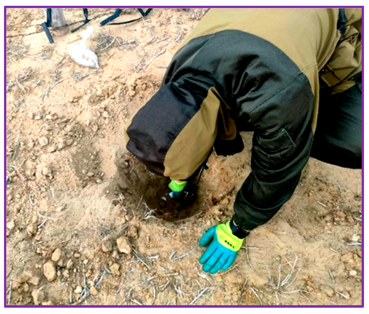
2.2. Field Measurements, Sampling, and Laboratory Analyses

The field studies verified the aquifer segment locations, including water and soil samples, and the geotechnical condition of the wells assessed. The sampling plan was prepared based on the study aims, standard behavior at the sampling sites, as well as issues of possible hazards. Taking into account the enormous size of the region under study, its accessibility (only in summer), and the location of the water intakes intended for irrigation, a plan was adopted for the one-time point sampling of the water from wells and soils in irrigated areas from a given well. The soil salinity was determined in test plots around the groundwater intakes. Sample plots were selected by consulting local farmers and agricultural authorities and were required to be typical for the study area as well as homogeneous in terms of the degree and type of soil salinity. The sampling was carried out with soil augers at the corners and in the center of the irrigated area under study, using the point sampling “envelope” method at the rate of one plot per 100 ha of an irrigated field. Soil samples were collected at a depth of 0–20 cm and 20–50 cm in a continuous column throughout the entire sampling interval (Figure 2).
Thirty-six soil samples were collected for granulometric analyses and analyses of the water–salt extract, humus, and petroleum product content. Twenty-three water samples were collected to determine the macro-component cationic and anionic composition, salinity, hardness, pH, and content of individual micro-components (Figure 3).
The soil and water sampling procedures were performed according to the Republic of Kazakhstan’s standard methods for monitoring and assessing irrigated land reclamation conditions. Historical information on agricultural land reclamation conditions was obtained from the Kazakh Ministry of Agriculture’s database [43]. The field testing included the selection and preparation of water points for sampling, the sampling and preservation of samples, and the visual determination of suspended and emulsified substances and insoluble sediments directly at the water source. Since the object of study was artesian self-flowing groundwater, there was no need for preliminary pumping from the wells. The use of groundwater confined to deep-lying aquifers predetermined the practical absence of seasonal fluctuations in their chemical composition. Water samples were collected in sterile 150 mL plastic bottles. The bottles were rinsed three times with the sample water. The bottles were then filled within four cm from the top and immediately closed to avoid air impact. Each bottle was labeled for identification. The bottle samples were then placed into a cooler with ice for laboratory delivery within one day. All chemical analyses were performed by the chemical laboratory of the Ahmedsafin Institute of Hydrogeology and Environmental Geoscience (Accreditation Certificate No. KZ.T.02.0782, valid until 27 November 2025). The chemical water sample analysis was conducted via a Mettler-Toledo liquid analyzer to measure the pH, conductivity, and dry residue. The sodium and potassium levels were determined with a PFP-7 flame photometer. Dissolved calcium, magnesium, nitrite, sulfate, chloride, and fluoride were measured using a Capel 105 M capillary electrophoresis (National Standard ST RK GOST R 51232) [44].
Electrolytes were prepared using the following reagents: potassium tetra chlorochromate (KTA-OH), diethylamino (DEA), tartaric acid, hydrochloric acid, and sodium hydroxide. The calibration results are expressed in mg/L. Boron (B) and silicon (Si) concentrations were measured using the KFK-2 photo colorimeter. The metals were analyzed using an ICPE-9820 emission spectrometer (International Standard ISO 17294-2:2003) [45]. Prior to analysis, samples were treated with nitric acid and filtered. Soil sample analysis methods and equipment used for determining individual soil parameters and error levels are summarized in Table 2. Laboratory tests were carried out according to the National Standard: PND F 16.1:2:2.3:2.2.69-10, ST RK 1273-2004, and GOST 26213-91 [46].
Laboratory analysis of the self and systematic quality control was performed to verify the chemical analysis results’ reliability and the technology of their implementation, as well as to prevent potential laboratory errors. When conducting soil mechanical analysis, the self-control amounted to 100% of the analyzed samples. A water extract analysis control was carried out by comparing the sum of anions and cations. A total of 20% of soil samples for chemical analysis were re-analyzed for comparison with the previously obtained results (systematic control).

2.3. Main Concepts and Methodology

The comprehensive assessment of the irrigation water quality is based on the following criteria: agronomic, groundwater suitability for irrigation, technical, and ecological. The agronomic criteria for determining the irrigation water quality rely on the following:
-
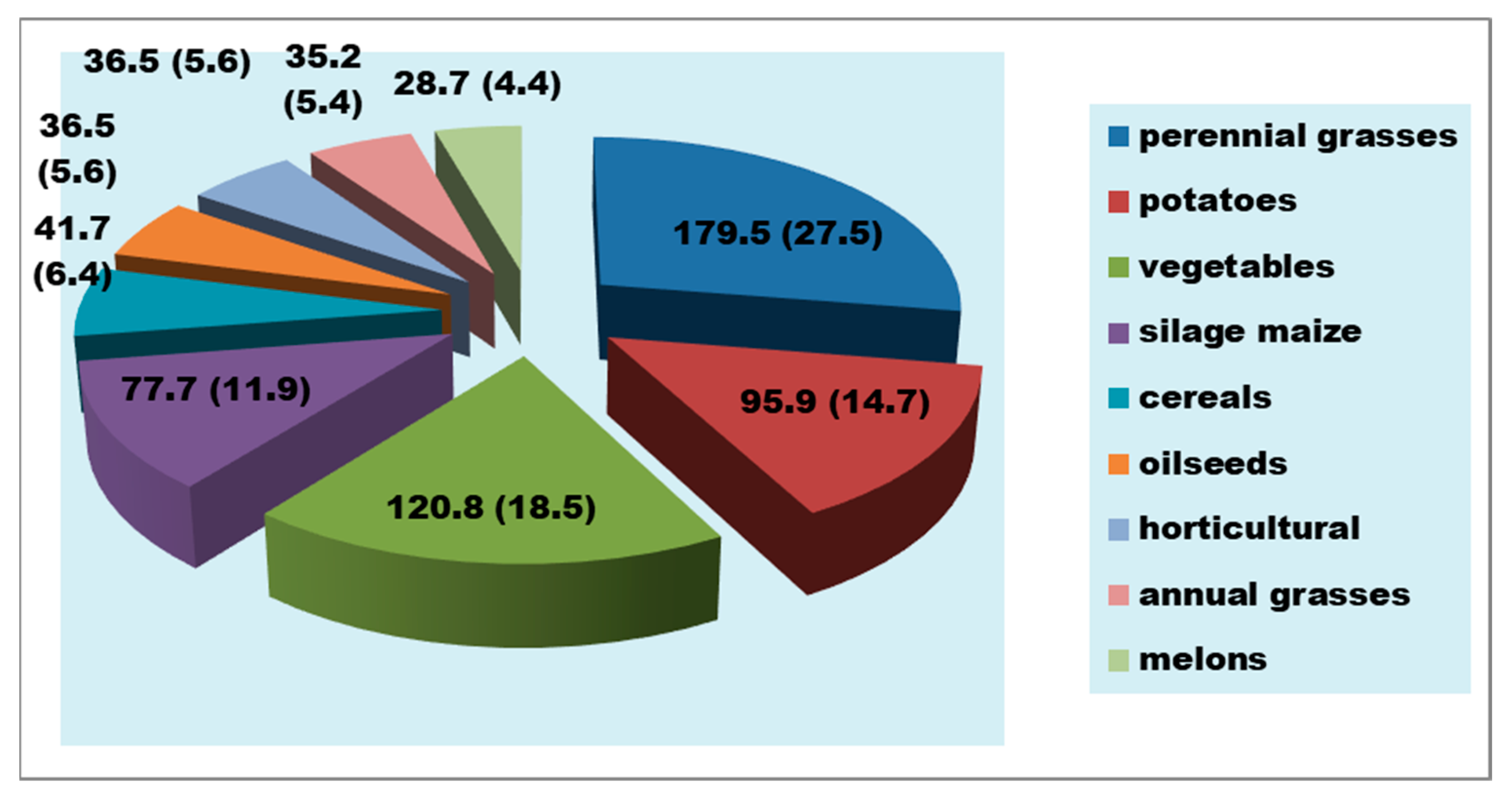
Crop yields in terms of gross yield and cultivation intensity;
-
The agricultural products’ quality, in terms of worth and safety;
-
Maintaining soil vitality and increasing fertility and also preventing the salinization, alkalinization, soda formation, compaction, and violation of the biological regime.
The technical criteria determine water quality in relation to its effect on the safety and efficiency of hydro-reclamation systems and their derivatives. The ecological criteria determine the irrigation water quality in the face of ensuring safe, sanitary, and hygienic conditions at the site for environmental protection.
To assess the irrigation water’s impact on the soil and the processes of salinization, alkalinization, and sodification, the following water quality indicators were used: TDS; main ions concentrations (Ca, Mg, Na, SO4, Cl, CO3, and HCO3), PH, the degree of the soil salinization hazard by the Cl/SO4 ratio; the degree of the soil alkalinization hazard by the exchangeable sodium percentage (ESP), the SAR, the hazard of magnesium alkalinization (Ca/Mg); and the degree of the danger of sodification by residual sodium carbonate ((CO3 + HCO3) − (Ca + Mg)). In the soil samples, a standard chemical analysis of 6 main chemical components was determined—Ca, Mg, Na, Cl, SO4, HCO3—as well as the TDS and type of salinity by the predominant anion and the granulometric composition of the soils.
The chemical composition of groundwater suitable for irrigation is considered via the irrigation coefficients, which, in the absence of uniform approved requirements, are calculated via approximate methods.
The irrigation water suitability was determined based on a chemical analysis using irrigation coefficients (Ka), which were calculated via the Staebler and Antipov-Karataev–Kader methods [47]. The Ka was calculated by the Staebler method according to Equations (1)–(3).
K a = 288 5 rCl ,   for   rNa + < rCl
K a = 288 rNa + + 4 rCl ,   for   rCl + rSO 4 2 > rNa + > rCl
K a = 288 10 rNa + 5 rCl 9 rSO 4 2 ,   for   rNa + > rCl + rSO 4 2
Ka was calculated via the Antipov-Karataev–Kader method according to Equation (4)
K a = rCa 2 + + rMg 2 + rNa + + 0.238 u
where r is the content of the corresponding ions in the irrigation water, mg-eq/L, and u is the sum of the ion content in the irrigation water, mg/L.
For the irrigation water’s suitability via the Staebler method, the irrigation coefficient value was evaluated according to the following criteria (Table 3).
The irrigation water assessment of the alkalinization risk was based on the sodium adsorption ratio (SAR), which represents the relative amount of sodium ions to the combined amount of calcium and magnesium ions (Equation (5)).
SAR = rNa + rCa 2 + rMg 2 + 2
This means that if the sodium concentration exceeds the divalent cations, there is a risk of calcium being displaced from the absorption complex and replaced by sodium. In this case, the soil may become alkalized with its rapidly deteriorating water–physical properties. The danger of soil alkalinization by irrigation water depends on the SAR coefficient [48], which was used for the assessment and classification (Table 4).
The groundwater quality and irrigation suitability class assessments are based on the degree of the dispersive soil development risk, which is carried out considering the exchangeable sodium percentage (ESP) (Equation (6)) and water salinity.
ESP = Na + Na + + Ca + + + Mg + + × 100  
The exchangeable sodium percentage (ESP) measures the proportion of cation exchange sites occupied by sodium. Soils are considered sodic when the ESP is greater than 6 and highly sodic when it is greater than 15 (FAO).
To assess the impact of irrigation water on soils, four irrigation water quality groups were classified, reflecting the risk of general salinization development, sodium and magnesium salinization, and sodic or dispersive soil processes (Table 5). The groundwater irrigation suitability is reduced from the first group to the fourth group. When one of the indicators is reduced, the suitability is reduced. While the water use in the first class does not have any restrictions, the third and fourth classes require prior water treatment for the irrigation of highly natural fertile lands.
Table 6 shows the degree of the irrigation suitability of water enriched with soluble salts, which depends on the type of soil, the soil adsorption complex (SAC), and irrigation water salinity.
Highly mineralized water can be used for the irrigation of permeable, well-drained soils. For heavy soils with poor drainage, the irrigation water salt content standards need to be reduced. Groundwater’s suitability according to its impact on drip irrigation system elements (Table 7) was assessed by determining the degree of impact in terms of the total mineralization, CO3 and Fe concentrations, and the active pH level of the water [50]. To determine the soil salinity level, the results of the soil sample water extraction analysis were used. The degree of soil salinity reflects the percentage of water-soluble salt in the dry residue as follows: non-saline—salt content less than 0.30%; slightly saline—salt content less than 0.5%; moderately saline—salt content less than 1.0%; highly saline—salt content less than 2.0%; and very highly saline—salt content > 2%. The types of soil salinity were defined according to the prevalence of anions and cations. The soil salinization type and degree were based on the Republican Instruction on the “Procedure for Determining the Type of Chemistry and Degree of Soil Salinization”, which provides the following sequence:
-
The average weighted content of all ions (in the 0–100 cm layer) was assessed. If this value was less than 0.1%, there was no salinization in the 0–100 cm layer for all types of salinization. In this case, the type of salinization chemistry is not determined, and the soils were classified as non-saline. If more than 0.1% and if the sum of CO3 + HCO3 was greater than the content of Ca, the type of chemistry was determined as soda.
-
In the absence of soda salinization, the ratio of the contents of chloride ions and sulfate ions was considered. If sulfate ions prevailed, then the salinization chemistry was determined as sulfate or chloride–sulfate (the predominant ion was put in last place).
-
If the content of chlorine ions was greater than the content of sulfate ions, then the type of salinization was determined to be either chloride or sulfate–chloride.
The conditionally suitable water for irrigation will require several agrotechnical and amelioration actions before its use.

2.4. Remote Sensing Data Processing

The Global Land Use/Land Cover Map (LULC), derived from ESA Sentinel-2 imagery on 26 June 2023 at a resolution of 10 m, was sourced from the arcgis.com open-source platform and then cropped and reclassified for the purpose of this study. The data for each year are generated from the Impact Observatory’s deep-learning AI land classification model, which employs a substantial training dataset developed by the National Geographic Society. The underlying deep-learning model utilizes six Sentinel-2 surface reflectance data bands, comprising the visible blue, green, and red bands, two shortwave infrared bands, and one near-infrared band. To create the final map, the model is run on multiple dates of imagery throughout the year, and the outputs are then combined to form a final representative map for each year (Sentinel-2, 2022).
The Normalized Difference Vegetation Index (NDVI) was calculated for each study area polygon. The NDVI primarily reflects vegetation greenness and health, serving as an indirect indicator of photosynthetic activity and biomass productivity [52,53]. Higher NDVI values are associated with an increased chlorophyll content and active vegetation growth, which can be used to estimate the vegetation cover and condition within a given area.
In Formula (1), NIR refers to the near-infrared region of the spectrum (0.7–1.0 μm), whereas red is reflected in the visible region of the spectrum (0.4–0.7 μm). The NDVI is the index of the spectral reflectivity of plants. Following the aforementioned Equation (7), the vegetation density (NDVI) at the remote point of the satellite image is equal to the difference between the intensities of the reflected light in the visible and infrared ranges, divided by the sum of their intensities.
NDVI = NIR RED NIR + RED
The NDVI calculation is based on the two most stable (independent of other factors) parts of the plant’s reflection spectral curve. In the visible region (0.4–0.7 µm), the maximum solar radiation absorption by chlorophyll occurred. In the infrared region (0.7–1.0 µm), the maximal leaf cellular structure reflection region was found. This is associated with a high photosynthetic activity, typically observed in dense vegetation, which leads to less reflection in the visible spectrum and more reflection in the infrared spectrum. The interrelationship of these indicators enables a clear distinction and analysis of the vegetation from other natural objects. Furthermore, recognizing vegetation types is also possible by the sub-satellite normalized difference between the minimum and maximum reflections rather than a simple relationship, which increases the sampling accuracy and reduces external factor effects, such as shading, clouds, haze, and atmospheric radiation absorption [54]. The NDVI is displayed on a standardized continuous gradient or discrete scale, with values ranging from −1 to 0.1, where negative values indicate water and non-living surfaces, while positive values correspond to different levels of vegetation cover [55]. To calculate the NDVI and NDSI, the ArcGIS 10.1 Raster Calculator tool was utilized, which enables the pixel-wise computation of spectral indices based on mathematical expressions. The dataset selection was guided by the phenophase of the cultivated crops and the surrounding environment. For selecting Sentinel-2 data, it is very important to take into account the correspondence between the survey period and the main stages of the vegetation phenophase for the study area [56]. Only cloud-free satellite images from the summer season were used, corresponding to the period when the chlorophyll content in irrigated fields reaches its peak, while the vegetation in the surrounding non-irrigated areas has largely dried out, minimizing the chlorophyll presence. This approach ensured a clear spectral contrast, allowing for an accurate assessment of the vegetation distribution and condition. Based on the commonly accepted ESRI classification of NDVI values, the following classification was used: −1 to 0—water bodies, clouds, and bare rocks; 0 to 0.2—barren soil, sand, and dead vegetation; 0.2 to 0.5—sparse, dry, or degraded vegetation (e.g., steppes and pastures); 0.5 to 0.7—moderately dense vegetation, grasslands, and cultivated crops in mid-growth stages; and 0.7 to 1.0—dense, healthy vegetation (forests and well-irrigated crops).
The Normalized Differential Salinity Index (NDSI) was calculated to detect the total salinity in the bare agricultural soils following Equation (8) [56,57].
NDSI = RED NIR NIR + RED
NDSI values approaching +1 indicate high soil salinity [58]. The red and NIR bands (8), which are used to calculate the NDSI, are the most sensitive to the soil ions that cause salinity [59]. High positive NDSI values indicate highly saline soil and low or negative NDSI values indicate low salinity or the absence of salinity in the soil.

2.5. Correlation Multivariate Analysis

To describe the degree of the correlation between groundwater quality parameters (Appendix A) and soil characteristics according to the degree of salinity and salinity type in irrigated lands (Appendix B), a multivariate correlation matrix [28,60] was used. The multivariate correlation matrix was constructed using the Excel analysis package [61]. The Pearson correlation coefficient (r) was used to assess the linear relationship between two variables. The calculated value of the coefficient ranges from −1 to +1. r = (+1) indicates a perfect positive linear relationship. As one variable increases, the other variable increases in a perfectly linear manner. r = (−1) indicates a perfect negative linear relationship. As one variable increases, the other variable decreases in a perfectly linear manner. Based on generally accepted interpretations of correlation coefficients [62], the following gradation was adopted. r = 0 indicates no linear correlation between the variables. A correlation coefficient (r) greater than 0.7 indicates a strong relationship, while an r less than 0.39 indicates a weak correlation. Values between 0.4 and 0.69 indicate a moderate correlation. In the correlation matrix, the arithmetic mean values of the soil characteristics were determined for the soil samples collected in the 0–20 cm and 20–50 cm intervals. This allowed us to characterize the soil root zone in the 0–50 cm interval as a whole.

3. Results

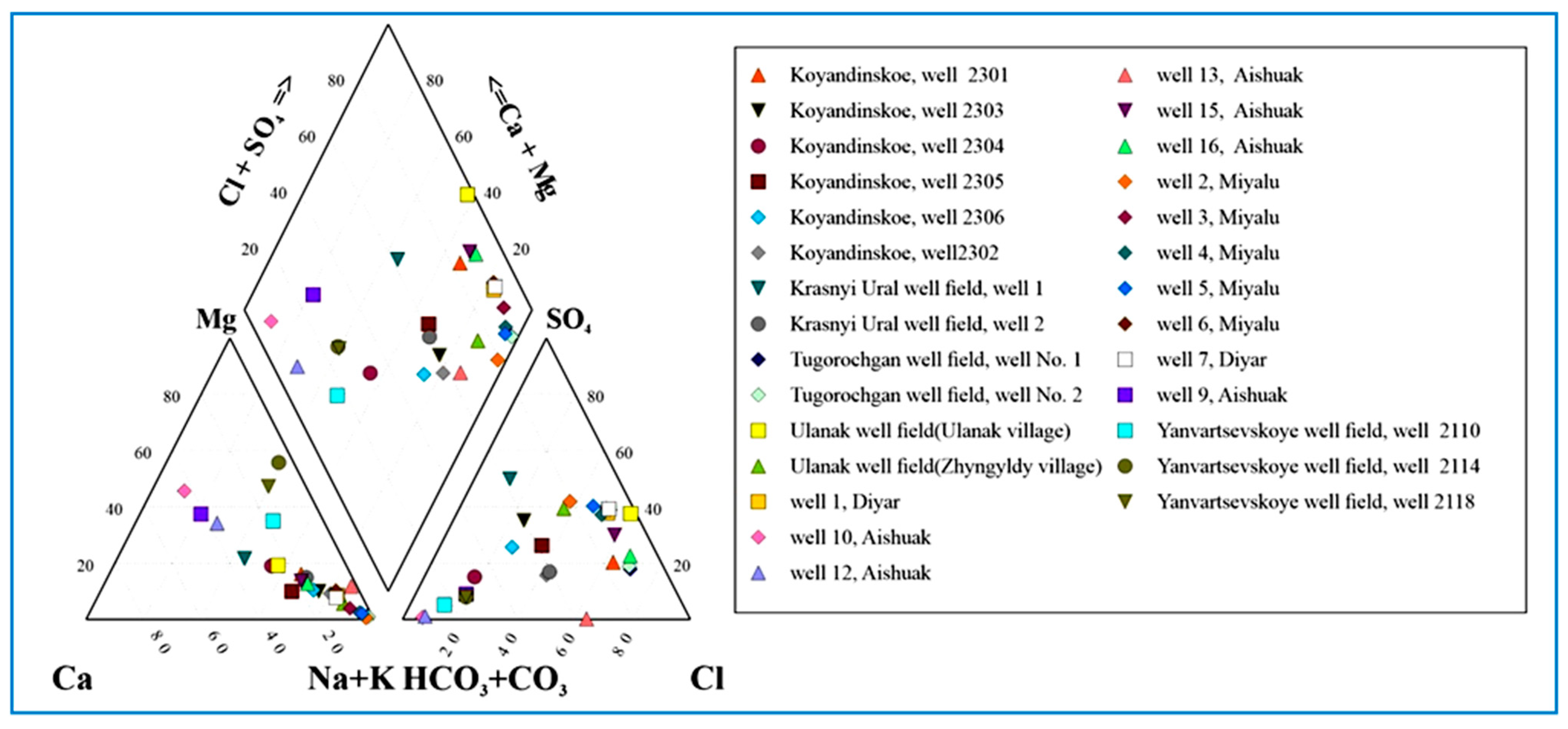
3.1. Irrigation Groundwater Chemistry

Irrigation-induced soil salinization can be caused by poor soil water management, manifested by high water tables, poor drainage conditions, and the use of saline–brackish water for irrigation. Soil salinization can also be caused by saline water irrigation, fertilizer salt input, and the intensification of evapotranspiration processes. The latter is enhanced by irrigation and the resultant water-balance shift toward an upward groundwater flow regime that prevents salt removal from the plant root zone. Irrigation promotes salt transfer by increasing the water flow gradients compared with non-irrigated conditions.
The chemical analysis results and the processing of groundwater samples from water intakes, represented by the Kurlov formula [63], are shown in Table 8. The micro-component chemical analyses are shown in Table 9.
The Mataykum and Myngyr aquifer segments represent slightly saline groundwaters with salinities ranging from 1.6 to 2.4 g/L, a total hardness ranging from soft to medium (0.75–6.9 mg-eq/L), and slightly alkaline water reactions (pH = 7.8–8.3). The water composition is sodium chloride–sulfate, with sodium and potassium contents ranging from 81 to 97 eq-%. The north Aishuak field is characterized by ultra-fresh and fresh water with a mineral content of 0.29 to 0.83 g/L. The water composition is hydro-carbonate calcium–magnesium–sodium, with a neutral acidity (pH 7.3–7.5) and a soft to moderate total hardness (2.2–7.1 mg/eq/L). The Aishuak deposits are characterized by its slightly saline water with a TDS value varying from 1.5 to 2.5 g/L, a neutral acidity (pH = 7.36–7.41), and total hardness ranging from soft to hard (2.8–12.7 mg-eq/L). The water composition is chloride, with chloride–hydro-carbonate and sodium chloride–sulfate occurring less frequently. The salinity of the groundwater of the Yanvartsevskoye well field is less than 0.3 g/L, which classifies the water as ultra-fresh. The groundwater is hydro-carbonate magnesium–sodium or sodium–magnesium, with a neutral, slightly alkaline reaction.
The groundwater of the Krasnouralskoye sub-aquifer is slightly saline, with a TDS value ranging from 1.1 to 1.2 g/L and sulfate–hydro-carbonate, chloride–hydro-carbonate sodium, and sodium–calcium compositions. The total hardness of the groundwater varies from medium-hard to hard (5.2–10.2 mg-eq/L), and the water mixture is neutral and slightly alkaline (pH 7.4–7.6). The Ulanak groundwater well field is weakly saline, with TDS values ranging from 1.4 to 6.6 g/L, and it has chloride–sulfate, sulfate–chloride–hydro-carbonate sodium, and sodium–calcium compositions. The total hardness varies from soft to very hard (2.7–47.0 mg-eq/L), and the water reactions vary from neutral to slightly alkaline (pH 7.1–8.0). The groundwater salinity in the Koyandy well field varies from 0.7 to 0.9 g/L, and only in one well was the groundwater TDS 2.4 g/L. In terms of total hardness, the groundwater is soft and moderately hard (3.2–6.1 mg-eq/L), with pH values ranging from 6.9 to 7.8. The chemical composition of the groundwater is sodium chloride and sodium hydro-carbonate.
The water sample anion and cation concentrations are shown in Figure 4 (Piper diagram [64]) and in Figure 5 using Durov’s diagram [65]. The chemical data depicted in the Piper diagram reveal various groundwater types, including Na-K-Cl, Ca-Cl, Ca-Mg-HCO3, mixite Ca-Na-Mg-HCO3, and Ca-Na-Cl. Durov’s diagram reflects the correlation between different anions and cation concentrations, pH values, and TDS. The fresh and ultra-fresh groundwater of the north Aishuak, Yanvartsevskoye, and Krasnouralskoye well fields is hydro-carbonate calcium–magnesium. The more saline groundwater of the other aquifers have chloride–sulfate, sulfate–chloride–hydrocarbonate sodium, and sodium–calcium compositions.
As Table 8 shows, the groundwater micro-component content generally does not exceed Kazakhstan’s industrial drinking water supply maximum permissible concentrations, with the exception of iron which significantly exceeds the maximum permissible concentration (0.3 mg/L). The reasons for the increased content of the divalent iron dissolved in groundwater, as well as precipitated trivalent iron, were analyzed and suggest that in all deep artesian wells, where aquifers are confined to sands occurring among clays (Ulanak) or to fine-grained sands with interlayers of clays and siltstones (Mataikumsky), the groundwater is saturated with iron, with clay rocks containing pyrite (FeS) that contribute iron to the water. The divalent iron formed in the groundwater in a dissolved form, according to the results of the analyses, is present in insignificant quantities, not exceeding 0.1 mg/L; but, with the wellbore’s prolonged enrichment with oxygen, the oxidation of divalent iron to trivalent iron occurred with the formation of iron oxide (Fe2O3) (the “rusting” process). Moreover, the tested wells have been in operation for more than 35–40 years. This content of trivalent iron accumulated in the water, which exceeds the maximum permissible concentration for the drinking water supply, does not have a negative impact on the productivity of fields during irrigation. If necessary, trivalent iron (rust) is much easier to remove than divalent as it is practically insoluble in water and forms a suspension that can be removed by settling, mechanical filtration, or forced sedimentation with flocculants.
The irrigation water’s chemical characteristics affect, first, the “soil solution–soil absorption complex” and, thus, practically all components of the soils’ water–salt regime. The irrigation properties of water are primarily determined by its total salinity (TDS value). Water that is characterized by a TDS value of less than 1 g/L has no potential irrigation problems, whereas water with a TDS value exceeding 3 g/L is generally not suitable for irrigation. From this point of view, the groundwater of the Ulanak and Ulanak–Tugorochgan well fields, with an increased salinity (TDS more than 3 g/L), are not recommended for use for irrigation (Appendix A). Soil alkalization, which consists of replacing divalent ions with monovalent ions in the soil exchange complex, is dangerous when soil is irrigated with waters of even relatively low mineralization.
The irrigation assessment of water in relation to its ability to alkalize soils is based on the relationship between the soil’s sodium absorption and the soda content in the water (irrigation coefficient according to Antipov-Karatayev and Kader), as well as the alkaline characteristic based on the content of sodium chlorides and sulfates in the water (Stebler irrigation coefficients) [47] (Table 3). The assessment of the irrigation water quality for the risk of alkalinization based on the calculation of the sodium adsorption ratio (SAR) is based on the fact that when the concentration of sodium exceeds divalent cations, there is a risk of it displacing calcium from the absorption complex and replacing it with sodium. In this case, the alkalinization of the soil with a sharp deterioration of its water–physical properties may occur (Table 4). The danger of the magnesium alkalinization of soils during irrigation is associated with the fact that a content of magnesium in large quantities and the ratio between the concentrations of magnesium and calcium, like sodium, negatively affect the properties of soils. Water alkalinity characterizes the danger of soda formation. As a result of calcium and magnesium precipitation in an alkaline environment, the ratio of cations changes in favor of sodium, increasing the alkalinizing effect of the irrigation water. To assess the alkalinity of the irrigation water, the indicator of (CO3 + H2CO3) − (Ca + Mg) is used, called “residual sodium carbonate” (Table 5 and Table 7). The integrated groundwater quality assessment, according to the risk of different types of soil salinization under irrigation, is shown in Table 10.
The studied groundwater well fields’ quality assessments according to sodic salinization or the dispersive soil development danger is described in Section 3.3.
The assessment of the groundwater’s suitability for irrigation, by considering the calculated irrigation coefficients of Staebler and Antipov-Karataev, Kader methods, TDS, the SAR, total hardness, and pH, is shown in Appendix A. Four irrigation water quality classes appear according to the degree of suitability. The groundwater of the first class is suitable for irrigation without limits. The second class is quite suitable for irrigation, but for only agricultural crops zoned in the region; the third class is limited in use, taking into account the local natural and irrigation conditions, and the fourth class is considered unsuitable for irrigation.
The assessment of the suitability of the water for irrigation depends not only on the composition of dissolved salts, but also on the type of soil and the plants grown. On easily permeable and well-drained soils, more mineralized water can be used, while on heavy soils with poor drainage, the salt content standards are reduced (Table 6). The irrigation water quality assessment according to the degree of soil salinity and the soil granulometric composition is described in Section 3.2.

3.2. Irrigation Water Quality Assessment According to Degree of Soil Salinity and Soil Granulometric Composition

The soil texture, as characterized by the fraction of sand, silt, and clay particles, affects both the movement of water and salts. The soil particle size affects interactions between the gravity, viscous, and capillary forces. This controls the water flow pathways, discharge speed, and pore water exchange, all of which impact salt transport in the soil [66]. According to the correlation analysis results [67], as the soluble salt content (TSS) increased, soil fractal dimensions (Dsoil) continued to rise, with an increasing content of clay, while the sand content decreased. Simultaneously, as the soil particles became finer, the TSS and Dsoil also increased, suggesting that sandy loams to silty soils in the study area were more prone to salt accumulation. The size and shape of the soil particles affect the pore morphology, and the interactions between the gravity, cohesion, and capillary forces can affect the movement of water and salts. The soil salinity is significantly affected by the clay content, with positive correlations between clay and silt fractions and negative correlations with sand. The soil characteristics and assessment are based on the degree of the total salinity and the salinity type of the explored aquifer segments (Table 6), as shown in Appendix B. The irrigation water quality assessment depends on the granulometric composition of soils, as shown in Appendix C.
The soils irrigated with the north Aishuak groundwater are light aeolian sandy loam and loam. The salt content percentage ranges from 0.17 to 0.60%, which is considered non-saline or slightly saline water. Aeolian heavy sands and loams are related to slightly medium saline groundwaters (0.69–0.94%). According to the cation ratio, the soil salinity type is calcium–magnesium, and the anion ratio is chloride–sulfate. The soil pH value is slightly alkaline (7.62–8.27). The soils irrigated with the Aishuak groundwater are represented by a heavy aeolian loam and belong to the non-saline category. According to the cation’s ratio, the soil salinity type is magnesium–calcium; in terms of anions, it is sulfate- and soda-type. In terms of pH, the soils are neutral (6.92) and slightly alkaline at the surface (7.97).
The soils irrigated by the Yanvartsevskoye well field are represented by heavy aeolian loams and medium-density clay. Both soil types belong to the medium salinity groundwater type (from 0.65 to 0.78%); according to the cation ratio, they are magnesium–calcium, and according to the anion ratio, it is a sulfate–soda type of salinization, with a weakly alkaline hydrogen ion active reaction (pH = 7.73). The Krasnouralskoye soils are characterized by light aeolian sands underlaid by light aeolian sandy loams, with a salt content from 0.18 to 0.21%. They are non-saline; in terms of the cation ratio, they are calcium–magnesium and sodium–calcium, and in terms of the anion ratio, they are chloride–sulfate and sulfate–chloride types of salinization, with a neutral acidity (pH = 6.7). The irrigated lands around the Ulanak well field are composed of light aeolian loams with a medium salt content (0.74–0.79%), with a cation ratio of calcium–sodium and an anion ratio of the chloride–soda type. They are characterized by being weakly alkaline and are closer to alkaline-active reactions (pH = 7.7–8.1).
The Mataykum aquifer segment soils are heavy aeolian, sandy loam, and loam, characterized by high salinities ranging from 1.80 to 2.7%. In terms of the cation ratio, the type of salinization is sodium, and the ratio is of the sulfate–chloride or chloride–sulfate type. In terms of the pH value, the groundwater is slightly alkaline to alkaline (7.7 to 8.37). The Myngyr aquifer soils are highly saline, with salt contents higher than 6% and sodium types of salinization by cations and soda chloride–sulfate types by anions.
The irrigation water quality assessment depends on the soil granulometric composition, shown in Appendix C. According to these results, the groundwater of the north Aishuak and Yanvartsevskoye well fields is safe for irrigation, the groundwater of the Krasnouralskoye well field is low-hazard, the groundwater of the Mataykum well is moderately dangerous, and other groundwater resources are dangerous for irrigation.

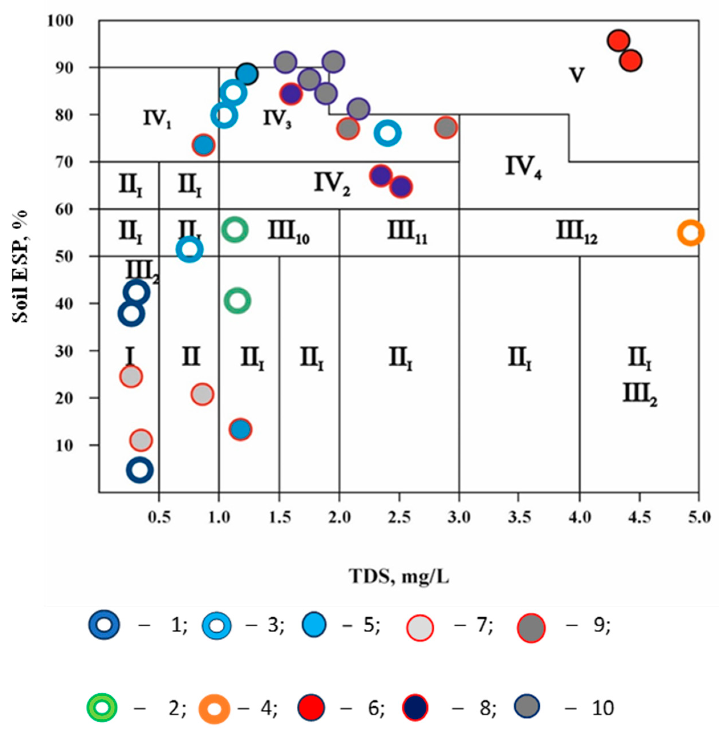
3.3. The Groundwater Quality Assessment of the Explored Deposits, i.e., the Soil Sodic or Dispersive Soil Development Danger Is Based on the Values of the Exchangeable Sodium Percentage and Water Salinity

Figure 6 shows the irrigation water class according to the degree of sodic salinization or dispersive soil development danger, which was determined by the soil ESP value and groundwater salinity (TDS). Soil alkalization (solonization) is the process of introducing sodium into the soil absorption complex (SAC). The more sodium there is among the other exchangeable cations of the SAC, the higher the soil solonization. The negative effect of solonization is that the organo-mineral mass of the soil containing sodium becomes more hydrophilic, i.e., it is capable of binding water in greater quantities. At the same time, the swelling of the soil increases in a wet state, and when drying out, clods and large cracks are formed. Soil colloids become more soluble and more mobile [11]. The assessment of the danger of soil solonization of irrigation water is established by the total salt content and the exchangeable sodium percentage (ESP). Figure 6 shows five classes of water and 12 groups. Class I water can be used for irrigating all crops on any type of soil. Its long-term use does not worsen the physical properties of the soil, and crop yields do not decrease compared to fresh water. Class II water is suitable for most crops and soil types. It slightly alkalizes the soil, and with its long-term use, the content of the absorbed sodium can reach 10% of the cation exchange capacity, and crop yields decrease by 5–20%. When irrigating chestnut and dark chestnut soils, it is necessary to use chemical ameliorants. Class III water causes soil alkalization, and crop yields decrease by 20–50% compared to fresh water. If it is necessary to use it, special agrotechnical measures are necessary. Class IV water is conditionally suitable; it causes soil alkalization. Class V water is not suitable for irrigation. The water groups III1, III2, III3, III4, and III5 require dilution and desalination. For groups III6, III7, and IV1 a chemical melioration is required. For groups III8, III9, III10, III11, III12, IV2, IV3, and IV4 dilution, desalination, and chemical melioration are required.
The classes reflect the integrated groundwater’s suitability for irrigation according to the salinization types on irrigated lands, as shown in Table 10.
The groundwater of the north Aishuak, Yanvartsevskoye, and, partially, Koyandy deposits are classified into the first and second classes and are suitable for most zoned agricultural crops on all soil types. Even the long-term use of very weakly salinized groundwater during an extended watering season does not deteriorate the physical properties of the soil. Compared with other classes of water, the crop yield is not reduced. With long-term use, the content of the absorbed sodium can reach up to 10% of the cation exchange capacity. The groundwater of the Krasnouralskoye, Koyandy, Aishuak, Mataykums, and, to a lesser extent, Ulanak–Kuibyshevo and Myngyr well fields were classified into the third and fourth classes. This groundwater usually causes sodic soil salinization. Zonal crop yields may decrease by up to 25–30%. A more detailed analysis of crop-specific salt tolerances under irrigation by groundwater sources is discussed in Section 3.4. The groundwater confined to the Ulanak and Tugyrakshan deposits is referred to as the fifth class and is considered unsuitable for irrigation.

3.4. Agricultural Crop Salt Tolerance Dependence on Irrigation Groundwater Quality and Western Kazakhstan’s Irrigated Soils

Crops have different salinity resistances; some can produce acceptable yields at much greater soil salinity than others. This is because some are more able to make the needed osmotic adjustments, enabling them to extract more water from the saline soil. In areas with a soil salinity build-up, which cannot be maintained at an acceptable concentration, an alternative crop should be selected that is both more tolerant of the expected soil salinity and can produce economic yields. The relative salt tolerance of most agricultural crops is known well enough to give general salt tolerance guidelines. Tolerances depend on the climate, soil conditions, and cultural practices. In gypsiferous soils, plants will tolerate about a 2 dS/m higher soil salinity (EC) than what is indicated for this crop during irrigation with the same water salinity [68]. To recommend agricultural crops on the basis of their salt tolerance under groundwater irrigation, four classification groups were proposed:
First group. Highly salt-tolerant zoned agricultural crops include wheat, rye, oats, barley, and sorghum, and fodder beet and barley for hay. The yield potential of these crops may reach 100% with irrigation by groundwater, with a total salinity of up to 3.5 g/L;
Second group. Strongly salt-tolerant zoned agricultural crops: wheat, rapeseed, sorghum, soya, sesame, melilot, alfalfa, barley for fodder, pumpkin, aubergines, red beetroot, and watermelons. Which have a 100% crop yield potential under irrigation by groundwater and a total salinity of up to 2.5 g/L;
Third group. Moderately salt-tolerant crops: wheat, silage maize, fodder millet, cabbage, beets, cucumbers, and tomatoes. The samples were irrigated with groundwater with a total salinity of up to 1.7 g/L, and the yield potential reached 100%.
Fourth group. Low-salt-tolerant crops include beans, peas, flax, sunflower, corn, buckwheat, clover, fodder beans, sown alfalfa, potatoes, melon, peas, pepper, radish, onion, carrot, cabbage, cauliflower, celery, fruit, and berries. The 100% yield potential of these crops is achieved through groundwater irrigation, with a total salinity of up to 1.3 g/L.
According to this criterion (Appendix A), the groundwater from all well fields, except Ulanak and Tugorochgan, is suitable for irrigating crops of the first and second groups of the crop salt tolerance. The groundwater from Aishuak, Mataykum, and Aishuak are not suitable for irrigating the third group, owing to the salt tolerance. The groundwater from other well fields (north Aishuak, Yanvartsevskoye, Krasnouralskoye, and Koyandy), with a total salinity of less than 1.3 g/L, is also suitable for irrigating crops belonging to group 4, with a tolerance to salinity.
The recommended complete crop rotations are based on the general state of the irrigated agriculture in the region under study, the existing and prospective structures of sown areas and crop yields, pricing policies, and the mandatory use of water-saving methods by introducing and replacing unprofitable surface irrigation technologies with sprinkler and drip irrigation technology [69]. The prospective structure of the crop areas on the irrigated lands of western Kazakhstan is aimed at introducing a forage–vegetable crop rotation to increase vegetable production and develop dairy farming. The most common crops in this region are potatoes, vegetables, cereals, and perennial grasses. The planned restructuring of the crop areas allows for a decrease in the share of annual grasses and grain crops and an increase in the share of vegetable crops, potatoes, and perennial grass. In a recommended irrigation regime for five complete crop rotations of the grains, technical crops, and vegetables over an allocated area of 653 km2 (Figure 7), the calculated net hydro-module is assumed to be 0.54 m3/day/km2; the average irrigation rate is 44.11 m3/km2, with an irrigation system efficiency of 85%. Moreover, restricted potato and perennial grass irrigation is recommended.

3.5. Assessment of Groundwater Suitability According to Its Impact on Sprinkler and Drip Irrigation Systems

West Kazakhstan’s development plan aims to improve the efficient utilization of groundwater resources, including the gradual exchange of the traditional flood irrigation with sprinkler and drip irrigation systems. The groundwater quality of almost all the assessed aquifer segments allows for their utilization in sprinkler irrigation systems without limits. The exceptions are the Aishuak and Myngyr segments, which require water quality improvement because of their high degree of mineralization. For drip irrigation, chemical clogging is usually related to insoluble calcium compounds that sediment in drippers [70,71].
Chemical clogging is caused by the insoluble materials generated from chemical reactions between cations (Ca, Fe, and Mg) and anions (CO3, HCO3, and SO4) in irrigation water. This plaque sediment gradually becomes increasingly thicker, eventually clogging the drip emitters. The groundwater suitability assessment, by the degree of its impact on the drip irrigation system elements, recommends the implementation of agricultural adjustments to regional irrigation schemes (Table 11). Owing to the high content of hydrocarbonates, the groundwater, with the exception of the Ulanak–Kuibyshevo groundwater, is not suitable for drip irrigation without prior improvement. In the three wells of the Myngyr sub-aquifer, high Fe ion concentrations were detected, which might also clog drip irrigation systems. For preventing the irrigation water’s chemical and biological contamination, carbonate, phosphate, and iron oxide deposits should be removed, and the drip irrigation system should provide reagent treatment and water aeration to improve the aerobiological qualities [72]. Open Chinese drip irrigation systems have been commonly applied in recent years in Kazakhstan, in small, irrigated areas (single-use drip tapes), with local manufacturing being developed. Such drip systems are in high demand and may replace expensive western drippers with emitters. The local system’s advantage emerges from its low cost, as drip tapes can be covered with soil to reduce the negative impact of high air temperatures during the growing season, which allows for the annual replacement of the system with a new one, thereby eliminating most of the problems of the clogging of drip tapes. This approach is more economical than sodium hexametaphosphate applied as a sequestrant (binding metal ions) water softening treatment for preserving the expensive drippers with emitters. The sodium carbonate added to increase the pH to 8.0–8.6, which partially acts as a pH stabilizer and softener, is also a dispersant that clarifies the water. The sodium hexametaphosphate deflocculant effect prevents colloidal, organic, and inorganic particles from sticking together, thereby protecting water from microbial growth in the event of flocculation (particle sticking together) and when this cannot be eliminated by conventional filtration.

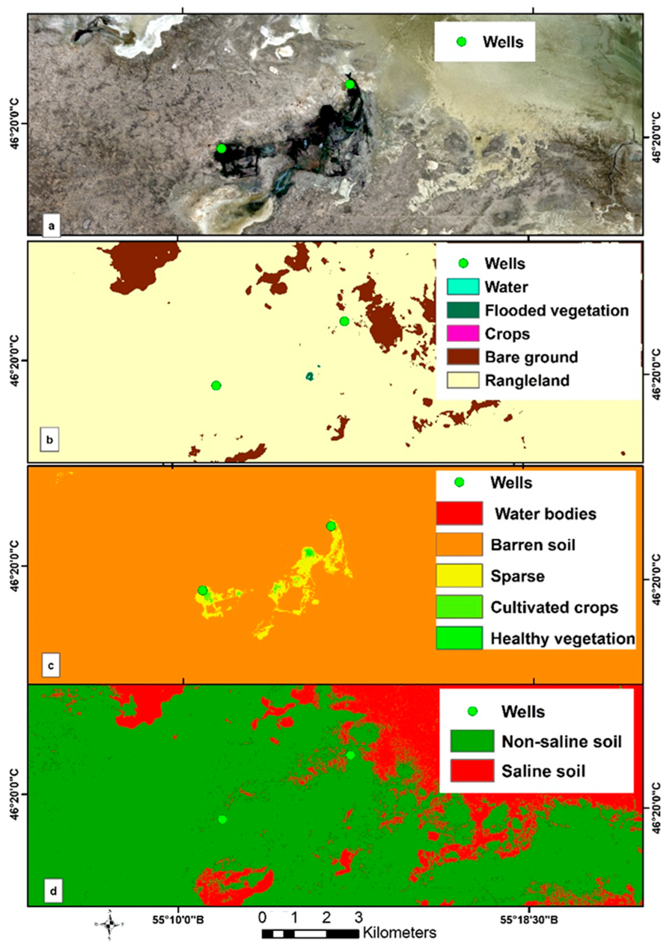
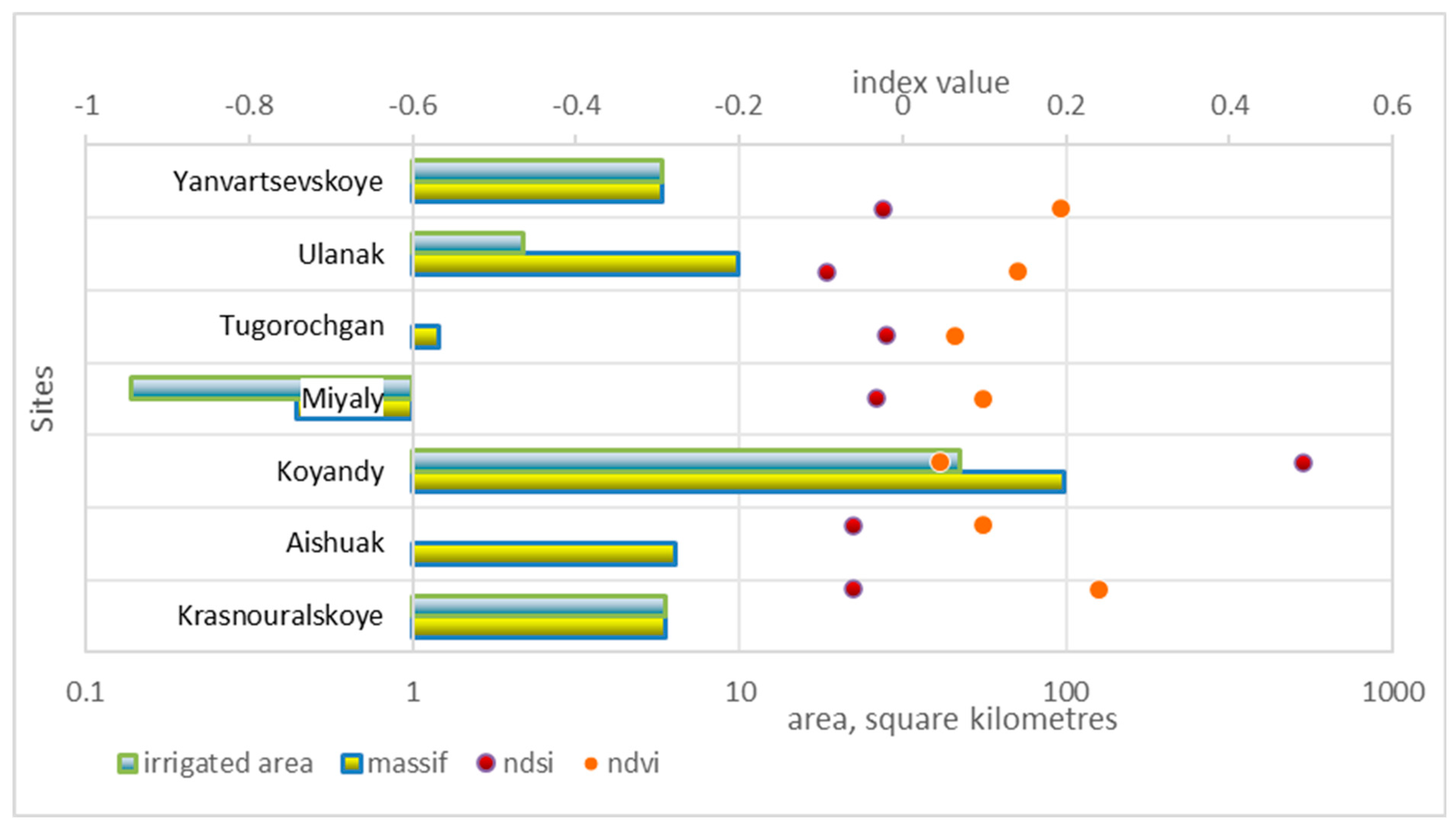
3.6. Assessment of Groundwater Suitability via Remote Sensing Methods

Figure 8 shows the mapping process of the land use and the NDVI and NDSI in one of the agricultural areas that was recommended for groundwater irrigation through the GIS and RS analysis.
The results of the Sentinel-2 medium-resolution (10 m per pixel) satellite analysis indicate that over half of the irrigated areas in the Aishuak, Koyandy, Miyaly, Tugorochgan, and Ulanak sites are not currently in use for agricultural purposes. At the Aishuak and Tugorochgan sites, approximately 16 km2 of the irrigated area is either abandoned or completely unused. The proportion of cultivated land within the total irrigated area is 48% in Koyandy, 31% in Miyaly, and 22% in Ulanak. The relatively low development rate of the irrigated areas can be attributed to the high levels of salinity and soil degradation, which exacerbate climatic factors. Figure 9 illustrates the extent and degree of the salinity of the irrigated land development region. The NDSI indicates that more than half of the irrigated areas at the Koyandy site are characterized by high salinity, with the northern region having a high prevalence of saline soil. The likelihood of irrigated land cultivation expansion remains low.
From the perspective of the expansion potential of the irrigated areas, the most promising sites are Yanvartsevskoye and Krasny Ural, which have been fully developed for irrigation. The NDSI, on average, is negative, indicating the absence of soil salinization.

3.7. Results from Correlation Analysis

The degree of the contribution of hydro-chemical parameters of the groundwater quality to the assessment of soil salinity during irrigation was determined using a correlation matrix of 19 parameters (Table 12). A strong positive correlation for the groundwater was observed between the TDS and Cl contents (r = 0.87) and also between the total hardness and Cl (r = 0.75). A strong positive correlation between the ions of Ca/Na and Ca/Mg (r = 075) indicates a high risk of simultaneous sodic and magnesium soil salinization under groundwater irrigation. A moderate positive correlation in the groundwater parameters was observed between the TDS and total hardness (r = 0.68), between the TDS and SAR (r = 0.54), between the Cl and SAR (r = 0.48) and the SAR and (CO3 + HCO3)—(Ca + Mg) (r = 0.46). The last parameter characterizes the danger of soda formation in the soil under irrigation.
A moderate positive correlation in the groundwater parameters also characterizes the relation between the Fe and HCO3 contents (r = 0.48). At the same time, the relation between Fe and PH is characterized by a moderate negative correlation (r = −0.55). The Staebler irrigation coefficient, which characterizes the suitability of water for irrigation, has a moderate negative correlation with the TDS (r = −0.4) and a weaker correlation with the Cl content (r = −0.36).
For the soil parameters connecting to the total degree of salinity and the type of salinity on the irrigation land, it is quite natural that a strong positive correlation is observed between the salt content and Ca/Mg (r = 0.71), Na/Mg (r = 0.74), and the pH (r = 0.82). A moderate positive correlation characterizes the relationship between PH and Ca/Mg (r = 0.49) and PHs and Na/Mg (r = 0.48) indicates that with increasing pH values in these ratios, Ca and Na cations begin to predominate in quantifying the degree of the soil salinization. In contrast, with an increasing pH, the decreasing ratios of Ca/Na and SO4/Cl indicate that in these ratios Na and Cl begin to predominate (r = −0.81 and r = −0.69, respectively). A moderate negative correlation is observed between Na/Mg and (HCO3 + CO3)/SO4 (r = −0.41) and between Na/Mg and (HCO3 + CO3)/Cl (r = −0.4).
Of particular interest is the correlation between the groundwater quality and soil salinity parameters under irrigation. A strong negative correlation characterizes the ratio between the TDS of the groundwater and the Ca/Na of the soil (r = −70), which is quite natural. A moderate negative correlation is observed between the groundwater total hardness and the Ca/Na of the soil and also the SO4/Cl ratios (r = −0.67 and r = −0.46, respectively). A similar correlation is observed between the groundwater Cl content and the Ca/Na ratio of the soil (r = −0.6).
A moderate positive correlation characterizes the relationship between the (CO3 + HCO3) − (Ca + Mg) of the groundwater and the Ca/Mg (r = 0.45) and Na/Mg of the soil (r = 0.5). This indicates that increasing carbonates in groundwater lead to increasing cations of Ca and especially Na in the soil (sodic processes in irrigated land). The groundwater total hardness is characterized by a moderate positive correlation with the soil pH (r = 0.53).
For the strongly correlated groundwater quality and type of soil salinity parameters (Table 12), regression equations linking these identified and correlated parameters were developed. Regression equations relating to these parameters are given in Table 13.
The TDS of the groundwater has a very strong positive correlation with Cl, indicating that with an increasing total salt concentration, the Cl ions in the groundwater also increase and the groundwater chemical composition changes to the chloride–sulfate–sodium–calcium type of salinity. A relatively high positive correlation between the total hardness and Cl ions, as well as between (Ca/Na) and (Ca/Mg) relations in the groundwater chemical composition, signifies that a greater groundwater hardness leads to the formation of the chloride–sodium groundwater type. On the analyzed irrigated sites, a relatively high positive correlation is observed between the soil salt content, (Ca/Na) and (SO4/Cl) relations, and the pH in the soil. Thus, it indicates that with an increase in soil salinity, the soils will be more alkaline with sodic soil salinization. At this time, a relatively high negative correlation between the pH and (Ca/Na) and (SO4/Cl) relations indicates that with soil alkalinity increasing, respectively, the Ca and SO4 content decreases, simultaneously with the Na and Cl content increasing in the soil. A moderate negative correlation between the TDS in water and (Ca/Na) in soil ratio also indicates that with irrigation by more saline water, the sodium salinization of the soil increases. The weak positive correlation between the increased groundwater salinity (TDS) in the water and the percentage of the salt content of the irrigated soil is obviously related to other factors influencing the soil salinization process, such as climatic, soil-amelioration, and agrotechnical conditions, but perhaps also to the relatively small number of soil samples used in this statistical analysis.

4. Discussion

Since irrigated agriculture in western Kazakhstan is embryonic, there are no experimental works or long-term observations of groundwater use for irrigation. As such, this study is the first comprehensive assessment of the groundwater quality’s suitability for irrigation. This research regarded soil characteristics in areas adjacent to the irrigation water source with linkages to applicable irrigation methods. The results obtained indicate that the suitability of the groundwater for agricultural use depends significantly on the type and degree of the irrigated soil salinization and the consequences of excessive irrigation. Methodological approaches to assessing groundwater quality in reference to various Water Quality Indexes (WQIs), enable the assessment of the quality and statistical processing of chemical components based on the scientific literature [5,6,14,15,17,20,22]. The present study utilized similar approaches to previous works, taking into account the specific nuances associated with the study area and the requirements of local standards. Values of the SAR, ESP, pH, and TDS parameters were calculated from measured values of chemical components. Although there are methods that can calculate the pH from the sodium adsorption ratio (SAR) or exchangeable sodium percentage (ESP) and electrical conductivity (EC) data, these methods are based on obtaining statistical correlations between these parameters. Since in this study the relationships reflect actual field sampling and laboratory analysis it provides a method for calculating the pH in soil salinity models which takes into account the effects of EC and sodium in the soil. It also provides a rapid method for estimating the SAR or ESP from readily available EC and pH data in the field. However, to obtain a reliable regression between the predicted and measured pH values and the SAR or ESP, a range of at least 2.5 pH units in the calibration data is required. Under these conditions, the predicted results were satisfactory [73].
The groundwater chemistry assessment indicates that the first quality class groundwater, including the north Aishuak, Krasnouralskoye, and Yanvartsevskoye aquifer segments, is suitable for the irrigation of all crops, does not deteriorate the physical properties of the soil, and does not reduce crop yields. The quality assessments by Stebler and Antipov-Karataev suggest that the sodium salinization risk of the soil relative to the SAR is closer to average (Appendix A). In sodic soils with an SAR > 13, the high exchangeable sodium in the soil complex causes the dispersion of its colloids, structural destruction, and aggregate failure, resulting in unfavorable physical properties, like a low infiltration rate and low hydraulic conductivity [11]. When the soil water salinity is insufficient to counteract the negative effects of adsorbed Na+ on the soil structure, a “rainfall effect” can occur. More specifically, the leaching of salts by excess irrigation water reduces the salinity of the soil solution. When dry, sodic soils become denser and structureless since the natural aggregation is destroyed. At the soil surface, dispersed clay particles can act as an adhesive, forming relatively dense crusts that impede seedling rooting and emergence. The degree of crusting depends on the soil texture, the mineralogy of the clay, the exchangeable sodium content, the energy of the raindrop impact, and the rate of drying [8]. The use of surface or sprinkler irrigation can increase the probability of soil structure degradation and surface crusting, while in drip-irrigated fields, this is hardly a problem, given the low flow rates of the drippers. The second quality class groundwater, including the Koyandy groundwater, is suitable for irrigating the crops already grown in the region and does not require improvement by a dilution with fresh water or a treatment with gypsum; it does not deteriorate the soil’s physical properties or reduce the crop yield, with cation content levels of up to 25 mg/L and Na+ contents of up to 40–65% of the cation sum. The groundwater of the third quality class (Aishuak, Mataykum, and Myngyr aquifer segments) is suggested for limited use and requires the monitoring of the soil and irrigation conditions. The suitability degree assessments were unsatisfactory for all the indicators. Nevertheless, where the groundwater intake was located close to the irrigated field (~100 m), this water was successfully used to grow watermelons and melons. The fourth groundwater class includes the Ulanak sub-aquifer, with an increased risk for plants, according to the irrigation coefficient value of the unsatisfactory quality, although the alkalinization risk according to the SAR value is medium. The groundwater is not suitable for irrigation and generally requires improvement by a dilution with fresh water or a treatment with gypsum. Nonetheless, this water is used by local farmers to irrigate watermelons, melons, cucumbers, tomatoes, and aubergines. For the irrigation of fruit trees, drip irrigation systems are used, and the water is also used for watering cattle. In all cases, it is necessary to determine the chemical composition of salt that might harm plants and soils; moreover, the permissible salt content may be greater in light soils than in heavy soils (Table 6).
While the north Aishuak aquifer groundwater is suitable for irrigation without restrictions, there is a risk of alkaline salinization, which requires caution and preventive chemical measures. The Mataykum aquifer groundwater is conditionally suitable for soil irrigation and recommended only when groundwater with a permissible level of salinity of not more than 0.5 g/L is used and under strict performance and chemical monitoring and washing, whenever reclamation is needed. The washing procedure involves burst washing at a rate of 15–20 thousand m3/ha and an operation at a rate of 8–12 thousand m3/ha, with a gypsum treatment after drainage. The standard soil gypsum treatment requires 7 to 10 tonnes per ha and needs to be carried out in two stages: before plowing and after cultivation. The Yanvartsevskiy aquifer irrigation water is ultra-fresh and is recommended for irrigating salt-tolerant crops with sprinklers and drip irrigation systems. The Krasnouralskoye aquifer groundwater can be used without restrictions to sow crops that have adapted to local conditions. The Ulanak aquifer groundwater is recommended only for salt-tolerant crops with an obligatory operational washing at rates of 10–15 thousand m3/ha to reduce the active alkaline reaction and the application of gypsum from 7 to 10 tonnes per ha in two steps—before plowing and after cultivation—with the dynamic monitoring of the secondary alkaline salinization. This groundwater is unsuitable for drip irrigation because of its high content of bicarbonates, or it can be used following acidification with a pH value of up to 7.0. This may be attained by applying phosphorus fertilizers, such as phosphoric acid. Sodium hexametaphosphate can be applied to prevent iron and manganese accumulation [72].
The groundwater quality results are closely related to pressing environmental issues at both the local and global levels. First, western Kazakhstan is highly susceptible to desertification, which is exacerbated by limited surface water and soil salinization. Desertification reduces land productivity, impacts biodiversity, and contributes to climate change through the loss of vegetation cover. The sustainable use of groundwater and innovative irrigation technologies, such as drip and sprinkler irrigation systems, can mitigate desertification by preventing soil salinization and alkalization. This is particularly relevant for reversing degradation trends and restoring drylands. Secondly, rising temperatures and reduced precipitation threaten water availability, increasing pressure on freshwater resources. Groundwater, as a more stable and less variable resource than surface water, can act as a buffer against the uncertainties of climate change. Moreover, poor water quality and unsustainable irrigation practices lead to soil salinization and reduced soil fertility, which harms microbial diversity and plant growth.

5. Conclusions

An integrated approach was used to assess the groundwater quality for irrigation, based on a comprehensive groundwater quality study. This was evaluated considering the types and degrees of the irrigated fields’ salinization, the impact of water on drip irrigation systems, and crops grown in the different segments of the aquifer in the Aktobe, Mangistau, and Atyrau regions of western Kazakhstan.
The operational water resources of these aquifers are 6520 thousand m3/day with a water mineralization up to 1 g/L and 12971 thousand m3/day with a water mineralization up to 3 g/L. Only about 10% of the groundwater is saline, with TDS values from 3 to 4.5–6.5 g/L.
Based on the comprehensive assessment, about 90% of the aquifer segments are considered suitable for irrigation. The saline groundwater of the Ulanak–Kuibyshevo and Myngyr aquifer segments is suitable for the limited irrigation of agricultural crops. The gradual development of salt-tolerant crops will add another 12,262 thousand m3/day of saline exploitable water for irrigation.
The recommended irrigated land area for development, based on groundwater, is 653 km2, which will require the restructuring of the cropping areas by reducing the share of annual grasses and grain crops and increasing the share of vegetables, potatoes, and perennial grasses.
It is recommended that the unsustainable traditional surface flooding be gradually replaced with drip irrigation and sprinkler systems.
This study highlights the importance of the joint monitoring of irrigation water and soil quality (e.g., TDS, SAR) to maintain the soil structure and fertility in irrigated fields. This study helps ensure water security in Kazakhstan during drought years and address water shortages due to transboundary issues and enables further sustainable socio-economic development in western Kazakhstan, contributing to food security and the adaptation to changing climate conditions.
The solutions developed here can serve as a basis for efforts to address similar issues in South Asia, the Middle East, and Central Asia, demonstrating how local research can contribute to global environmental sustainability.

Author Contributions

Y.M. was responsible for the conceptualization, formal analysis, methodology, and writing of the manuscript. V.K. was responsible for the computational part and research results and writing the original draft preparation. V.M. was responsible for the formal analysis, methodology, reviewing, and writing the original draft. Y.A. was responsible for the writing—reviewing and editing and conceptualization. T.R. was responsible for organizing and conducting the expedition research. V.R. was responsible for analyzing, preparing tables, and digitizing the graphics. Z.O. was responsible for the GIS and RS analyses. All authors have read and agreed to the published version of the manuscript.

Funding

This research has been funded by the Science Committee of the Ministry of Science and Higher Education and Science of the Republic of Kazakhstan («Groundwater resources as the main reserve of sustainable irrigated agriculture in Kazakhstan» № BR 21882211).

Data Availability Statement

The data presented in this study are available on request from the corresponding author.

Conflicts of Interest

The authors declare no conflicts of interest.

Appendix A

Table A1. Classification of groundwater quality according to suitability for irrigation.
Groundwater DepositWell NoWater Quality ClassGroundwater Quality Assessment According to:
TDS, g/LpHTotal Hardness, mg-eq/LKa
by Staebler
SARKa by Antipov-Karataev–Kader
North Aishuak9II0.83 (F)7.5 (N)7.05 (MH)36.5 (VG)10.0 (L)C > Tк 1.1 > 0.19 (SU)
10I0.42 (UF)7.29 (N)3.4 (SO)6.78 (G)13.4 (CM)C > Tк 5.4 > 0.09 (SU)
12I0.29 (UF)7.29 (N)2.2 (SO)0.56 (G)13.9 (CM)C > Tк 2.15 > 0.07 (SU)
Aishuak13III1.52 (SB)7.36 (N)2.8 (SO)3.84 (SAT)14.83 (CM)C < Tк 0.095 < 0.35 (SU)
15III2.36 (SB)7.37 (N)12.65 (VH)1.2 (UNS)14.19 (CM)C < Tк 0.36 < 0.54 (SU)
16III2.52 (SB)7.41 (N)12.3 (VH)2.11 (SAT)15.39 (CM)C < Tк 0.36 < 0.58 (SU)
Mataykum1III2.09 (SB)7.82 (SA)5.75 (MH)3.49 (SAT)18.97 (CM)C < Tк 0.14 < 0.49 (SU)
6III2.41 (SB)7.91 (SA)6.9 (MH)3.67 (SAT)16.3 (CM)C < Tк 0.16 < 0.55 (SU)
Myngyr2III1.62 (SB)8.32 (SA)2.8 (SO)2.7 (SAT)38.25 (HI)C < Tк 0.026 < 0.37 (SU)
3III2.27 (SB)7.96 (SA)3.4 (SO)3.16 (SAT)12.3 (L)C < Tк 0.09 < 0.52 (SU)
4III2.2 (SB)8.14 (SA)2.0 (SO)3.32 (SAT)21.31 (M)C < Tк 0.05 < 0.51 (SU)
6III1.87 (SB)7.9 (SA)1.5 (SO)1.25 (SAT)31.9 (HI)C < Tк 0.04 < 0.43 (SU)
Yanvartsevskoye2118I0.26 (UF)7.85 (SA)1.85 (SO)6.45 (G)2.62 (L)C > Tк 0.91 > 0.21 (SU)
2114I0.26 (UF)7.85(SA)2.95 (SO)6.72 (G)3.26 (L)C > Tк 0.86 > 0.20 (SU)
2110I0.31 (UF)8.2 (SA)2.25 (SO)7.13 (G)3.4 (L)C > Tк 0.71 > 0.16 (SU)
Krasnouralskoye4I1.23 (SB)7.44 (N)10.2 (H)6.89 (G)6.77 (L)C > Tк 0.93 > 0.28 (SU)
5I1.1 (SB)7.2 (N)5.2 (MH)6.9 (G)9.47 (L)C > Tк 0.31 > 0.25 (SU)
UlanakNoIV6.63 (S)7.71 (SA)47 (SA)0.9 (UNS)19.71 (CM)C < Tк 0.56 < 1.52 (SU)
Ulanak,
Zhyngyldy
NoIII1.4 (SB)7.96 (SA)2.7 (SO)0.56 (UNS)15 (CM)C < Tк 0.11 < 0.32 (SU)
Ulanak, Tugorochgan1IV4.44 (B)7.99 (SA)2.1 (SO)0.87 (UNS)173.9 (HI)C < Tк 0.02 < 1.02 (SU)
2IV4.32 (B)7.99 (SA)1.55 (SO)0.45 (UNS)73.38 (HI)C < Tк 0.02 < 0.99 (SU)
Koyandy2301III2.4 (SB)6.9 (N)12.6 (VH)2.4 (SAT)0.09 (L)C < Tк 0.35 < 0.55 (SU)
2302II1.1 (SB)7.89 (SA)3.2 (SO)8.3 (SAT)2.13 (L)C < Tк 0.17 < 0.25 (SU)
2303II1.31 (SB)7.78 (SA)4.6 (MH)12.15 (G)1.87 (L)C < Tк 0.23 < 0.30 (SU)
2304II0.7 (F)7.45 (N)4.5 (MH)32 (G)0.67 (L)C > Tк 0.59 > 0.16 (CU)
2305III1.2 (SB)7.8 (SA)5.8 (MH)9.26 (SAT)5.07 (L)C > Tк 0.38 > 0.27 (CU)
2306II0.9 (F)7.84 (SA)3.3 (SO)17.67 (G)0.83 (L)C > Tк 0.26 > 0.21 (CU)
Notes: in the table, TDS: UF—ultra-fresh; F—fresh; SB—slightly brackish; B—brackish; S—salty; pH: N—neutral; SA—slightly alkaline; total hardness: SO—soft; MH—medium hard; H—hard; VH—very hard; Ka by Staebler: VG—very good; G—good; SAT—satisfactory; UNS—unsatisfactory; SAR: L—low; CM—close to medium; M—medium; HI—high; Ka by Antipov-Karataev—Kader: SU—suitable; CU—closer to usable.

Appendix B

Table A2. The characteristics and assessment of the soils according to the total degree of salinity and type of salinity on the irrigation land connected to aquifer segments.
AquiferDepth Interval from Soil Surface, mSoil TypeSoil Characteristics and Land Assessment According to the Soil SalinitypH
By Salt Content, %Soil Salinity Type by Cation Ratio, mg-eqSoil Salinity Type by Anion Ratio, mg-eq
Ca/MgCa/NaNa/MgMajor ActionsHCO3 + CO3/SO4HCO3 + CO3/ClSO4/ClSalinity Type
Mataykum 1/0.0–0.20Heavy silty sandy loam1.04 (MS)3.330.349.96Na, Mg14.49100.69Sodas8.11
1/0.0–0.50Silty light loam2.5 (HS)40.0845.44Na1.282.061.6Soda sulfate8.37
2/0.0–0.20Heavy silty sandy loam1.8 (HS)22.40.05400.8Na590.651.09Chloride-sulfate7.35
2/0.0–0.50Heavy silty sandy loam2.5 (HS)0.630.0414.1Na0.440.330.76Chloride-sulfate7.88
3/0.0–0.20silty heavy loam1.3 (MS)2.090.415.11Na11.28.30.74Chloride sodas8.16
3/0.0–0.50silty heavy loam2.7 (HS)1.170.0430.48Na0.40.270.68Sulfate chloride7.7
Myngyr4/0.0–0.20Silty light loam6.2 (VHS)230.032708.2Na0.280.41.62Soda chloride sulfate8.76
4/0.0–0.50Heavy silty sandy loam6.1 (VHS)38.50.05749.5Na0.340.351.03Soda chloride sulfate8.38
Yanvartsevskoye5/0.0–0.20silty heavy loam0.65 (MS)2.262.430.93Mg, Ca13.89.280.67Sulfated sodas7.73
5/0.0–0.50clay0.78 (MS)13.88.960.71Mg, Ca11.4124.32.13Sulfate chloride7.43
Krasnouralskoye6/0.0–0.20silty sand0.21 (US)0.8311.360.07Ca, Mg0.2613.78Chloride-sulfate6.7
6/0.0–0.50silty light sandy loam0.18 (US)1.27.360.16Na, Ca0.6410.16Sulfate chloride6.7
Ulanak7/0.0–0.20Silty light loam0.79 (MS)4.991.762.8Ca, Na4.383.00.68Chloride sodas7.7
7/0.0–0.500.74 (MS)2.661.02.7Ca, Na20.973.600.17Sulfated sodas8.06
Ulanak,
Zhyngyldy site
8/0.0–0.20Silty light loam0.78 (MS)1.381.4426.9Ca, Mg7.987.50.94Sulfated sodas8.06
8/0.0–0.501.2 (MS)7.160.917.85Ca, Mg15.716.871.07Sulfated sodas8.22
Ulanak, Tugorochgan site 9/0.0–0.20Heavy silty sandy loam5.6 (VHS)4.20.0355.3Ca, Mg3.0311.130.37Sulfated sodas8.76
North Aishuak10/0.0–0.20Light silty sandy loam0.17 (US)0.777.90.09Ca, Mg3.1951.56Sodas6.86
10/0.0–0.50Silty light loam0.6 (MS)0.91.340.67Ca, Mg7.977.850.98Chloride-sulfate8.27
11/0.0–0.20Heavy silty sandy loam0.37 (MS)1.676.40.26Na, Ca5.4711.72.13Sulfated sodas7.43
11/0.0–0.50Heavy silty sandy loam0.69 (MS)2.988.650.34Na, Ca8.5101.2Sulfated sodas7.62
12/0.0–0.20Heavy silty sandy loam0.37 (MS)1.676.40.26Na, Ca5.4711.72.13Sulfated sodas7.41
12/0.0–0.50silty sand0.94 (MS)2.8711.550.24Na, Ca44.228.750.65Sulfated sodas8.04
Aishuak13/0.0–0.20Heavy silty sandy loam0.66 (MS)4.347.780.56Na, Ca17.9140.78Sulfated sodas7.97
13/0.0–0.50Heavy silty sandy loam0.2 (US)0.660.531.24Na, Ca1.12.52.25Sulfated sodas6.92
Notes: table—soil salinity by soil content: US, unsalted; MS, moderately saline; HS, highly saline; and VHS, very highly saline.

Appendix C

Table A3. Irrigation water quality assessment depending on granulometric composition of soils.
Groundwater DepositSampling Point Number/Depth Interval from Soil Surface, mSoil TypeCharacteristics and Assessment of Irrigated Sites According to the Level and Type of the Soil SalinitySoil Granulometric Composition Characteristics and Assessment of Irrigation Water Quality
By Salt Content, %Soil Salinity Type by Cation RatioSoil Salinity Type by Anion RatioTDS
g/L
Irrigation Water Quality ClassIrrigation Water Quality Assessment
North Aishuak 10/0.0–0.20Silty light sandy loamUSCa, MgSodaslight particle size0.42Inonhazardous
10/0.0–0.50Silty light loamMSCa, MgChloride-sulfatelight particle size
11/0.0–0.20Heavy silty sandy loamMSMg, CaSulfated sodasheavy particle size0.29Inonhazardous
11/0.0–0.50Heavy silty sandy loamMSMg, CaSulfated sodasheavy particle size
Aishuak13/0.0–0.20Heavy silty sandy loamMSMg, CaSulfated sodasheavy particle size1.52IVhazardous
13/0.0–0.50USMg, CaSulfated sodas
Mataykum1/0.0–0.20Heavy silty sandy loamHSNa, MgSodasheavy particle size1.52IIImoderately hazardous
1/0.0–0.50Silty light loamMSNaSoda sulfatelight particle sizeIIImoderately hazardous
Myngyr4/0.0–0.20Silty light loamVHSNaSoda chloride sulfatelight particle size2.7IIImoderately hazardous
4/0.0–0.50Heavy silty sandy loamVHSNaSoda chloride sulfateheavy particle sizeIVhazardous
Yanvartsevskoye5/0.0–0.20Silty heavy loamMSMg, CaSulfated sodasheavy particle size0.27Inonhazardous
5/0.0–0.50ClayMSMg, CaSulfate chlorideheavy particle size
Krasnouralskoye6/0.0–0.20Silty sandUSCa, MgChloride–sulfatelight particle size1.11IIlow-hazardous
6/0.0–0.50Silty light sandy loamUSNa, CaSulfate chloridelight particle size
Ulanak7/0.0–0.20Silty light loamMSCa, NaChloride sodaslight particle size6.63IV hazardous
7/0.0–0.50MSSulfated sodas
Ulanak,
Zhyngyldy site
8/0.0–0.20Silty light
loam
MSCa, MgSulfated sodaslight particle size1.40IIImoderately hazardous
8/0.0–0.50MS
Ulanak, Tugorochgan site0.0–0.20Heavy silty sandy loamVHSCa, NaSulfated sodasheavy particle size4.22IVhazardous
Notes: table—soil salinity by soil content: US, unsalted; MS, moderately saline; HS, highly saline; and VHS, very highly saline.

References

  1. Sandström, C.; Ring, I.; Olschewski, R.; Simoncini, R.; Albert, C.; Acar, S.; Adeishvili, M.; Allard, C.; Anker, Y.; Arlettaz, R.; et al. Mainstreaming Biodiversity and Nature’s Contributions to People in Europe and Central Asia: Insights from IPBES to Inform the CBD Post-2020 Agenda. Ecosyst. People 2023, 19, 2138553. [Google Scholar] [CrossRef]
  2. Margat, J.; van der Gun, J. Groundwater Around the World; Taylor & Francis Group: Boca Raton, FL, USA, 2013; ISBN 9788578110796. [Google Scholar]
  3. Katsanou, K.; Karapanagioti, H.K. Surface Water and Groundwater Sources for Drinking Water. Handb. Environ. Chem. 2019, 67, 1–19. [Google Scholar] [CrossRef]
  4. United Nations. Groundwater: Making the Invisible Visible; United Nations: New York, NY, USA, 2022; ISBN 978-92-3-100507-7. [Google Scholar]
  5. Asadi, E.; Isazadeh, M.; Samadianfard, S.; Ramli, M.F.; Mosavi, A.; Nabipour, N.; Shamshirband, S.; Hajnal, E.; Chau, K.W. Groundwater Quality Assessment for Sustainable Drinking and Irrigation. Sustainability 2020, 12, 177. [Google Scholar] [CrossRef]
  6. Venkateswaran, S.; Vijay Prabhu, M.; Mohammed Rafi, M.; Vallel, K.L.K. Assessment of Groundwater Quality for Irrigational Use in Cumbum Valley, Madurai District, Tamilnadu, India. Nat. Environ. Pollut. Technol. 2011, 10, 207–212. [Google Scholar]
  7. Nikolaou, G.; Neocleous, D.; Christou, A.; Kitta, E.; Katsoulas, N. Implementing Sustainable Irrigation in Water-Scarce Regions under the Impact of Climate Change. Agronomy 2020, 10, 1120. [Google Scholar] [CrossRef]
  8. Tomaz, A.; Palma, P.; Fialho, S.; Lima, A.; Alvarenga, P.; Potes, M.; Costa, M.J.; Salgado, R. Risk Assessment of Irrigation-Related Soil Salinization and Sodification in Mediterranean Areas. Water 2020, 12, 3569. [Google Scholar] [CrossRef]
  9. Minhas, P.S.; Qadir, M.; Yadav, R.K. Groundwater Irrigation Induced Soil Sodification and Response Options. Agric. Water Manag. 2019, 215, 74–85. [Google Scholar] [CrossRef]
  10. Strawn, D.; Bohn, H.L.; O’Connor, G.A. Soil Chemistry; John Wiley Blackwell: Hoboken, NJ, USA, 2020; 356p. [Google Scholar]
  11. Anker, Y.; Mirlas, V.; Zilberbrand, M.; Oren, A. Chemical Reactivity: PH, Salinity and Sodicity Effects on Soil Health. In Laboratory Methods for Soil Health Analysis; Karlen, D.L., Stott, D.E., Mikha, M.M., Eds.; John Wiley & Sons, Inc.: Hoboken, NJ, USA, 2021; Volume 2, pp. 78–108. ISBN 9780891189831. [Google Scholar]
  12. Korolyuk, T.V. Specific Features of the Dynamics of Salts in Salt-Affected Soils Subjected to Long-Term Seasonal Freezing in the South Transbaikal Region. Eurasian Soil Sci. 2014, 47, 339–352. [Google Scholar] [CrossRef]
  13. Kostyakov, Alexey Nikolaevich—Osnovy Melioratsiy. In Russian/Basics of Reclamation. Available online: https://www.livre-rare-book.com/book/30378290/6244295 (accessed on 7 March 2025).
  14. Suarez, D.L. Irrigation water quality assessments. In Agricultural Salinity Assessment and Management; ASCE: Reston, VA, USA, 2012; pp. 343–370. [Google Scholar]
  15. Abbasnia, A.; Radfard, M.; Mahvi, A.H.; Nabizadeh, R.; Yousefi, M.; Soleimani, H.; Alimohammadi, M. Groundwater Quality Assessment for Irrigation Purposes Based on Irrigation Water Quality Index and Its Zoning with GIS in the Villages of Chabahar, Sistan and Baluchistan, Iran. Data Br. 2018, 19, 623–631. [Google Scholar] [CrossRef]
  16. Adimalla, N.; Qian, H. Groundwater Quality Evaluation Using Water Quality Index (WQI) for Drinking Purposes and Human Health Risk (HHR) Assessment in an Agricultural Region of Nanganur, South India. Ecotoxicol. Environ. Saf. 2019, 176, 153–161. [Google Scholar] [CrossRef]
  17. Batarseh, M.; Imreizeeq, E.; Tilev, S.; Al Alaween, M.; Suleiman, W.; Al Remeithi, A.M.; Al Tamimi, M.K.; Al Alawneh, M. Assessment of Groundwater Quality for Irrigation in the Arid Regions Using Irrigation Water Quality Index (IWQI) and GIS-Zoning Maps: Case Study from Abu Dhabi Emirate, UAE. Groundw. Sustain. Dev. 2021, 14, 100611. [Google Scholar] [CrossRef]
  18. Ravi, K.P.; Periasamy, S. Systematic Discrimination of Irrigation and Upheaval Associated Salinity Using Multitemporal SAR Data. Sci. Total Environ. 2021, 790, 148148. [Google Scholar] [CrossRef] [PubMed]
  19. Phogat, V.; Mallants, D.; Cox, J.W.; Šimůnek, J.; Oliver, D.P.; Awad, J. Management of Soil Salinity Associated with Irrigation of Protected Crops. Agric. Water Manag. 2020, 227, 105845. [Google Scholar] [CrossRef]
  20. Al-Aizari, H.S.; Aslaou, F.; Mohsen, O.; Al-Aizari, A.R.; Al-Odayni, A.B.; Abduh, N.A.Y.; Al-Aizari, A.J.M.; Taleb, E.A.B.O. Assessment of Groundwater Quality for Irrigation Purpose Using Irrigation Water Quality Index (Iwqi). J. Environ. Eng. Landsc. Manag. 2024, 32, 1–11. [Google Scholar] [CrossRef]
  21. Nagaiah, E.; Sonkamble, S.; Mondal, N.C.; Ahmed, S. Natural Zeolites Enhance Groundwater Quality: Evidences from Deccan Basalts in India. Environ. Earth Sci. 2017, 76, 536. [Google Scholar] [CrossRef]
  22. Çadraku, H.S. Groundwater Quality Assessment for Irrigation: Case Study in the Blinaja River Basin, Kosovo. Civ. Eng. J. 2021, 7, 1515–1528. [Google Scholar] [CrossRef]
  23. Gaagai, A.; Aouissi, H.A.; Bencedira, S.; Hinge, G.; Athamena, A.; Haddam, S.; Gad, M.; Elsherbiny, O.; Elsayed, S.; Eid, M.H.; et al. Application of Water Quality Indices, Machine Learning Approaches, and GIS to Identify Groundwater Quality for Irrigation Purposes: A Case Study of Sahara Aquifer, Doucen Plain, Algeria. Water 2023, 15, 289. [Google Scholar] [CrossRef]
  24. Bhatnagar, A.; Thakral, N. Assessment of Groundwater Quality for Drinking and Irrigation Purposes Using Hydro-Chemical and Water Quality Index Studies in Kurukshetra (Haryana), India. Water. Air. Soil Pollut. 2024, 235, 351. [Google Scholar] [CrossRef]
  25. Anker, Y. Hydrogeochemistry of the Central Jordan Valley. Ph.D. Thesis, Tel Aviv University, Tel Aviv, Israel, 2007. [Google Scholar]
  26. Mirlas, V.; Anker, Y.; Aizenkod, A.; Goldshleger, N. Irrigation Quality and Management Determine Salinization in Israeli Olive Orchards. Geosci. Model Dev. 2022, 15, 129–143. [Google Scholar] [CrossRef]
  27. Mirlas, V.; Makyzhanova, A.; Kulagin, V.; Kuldeev, E.; Anker, Y. An Integrated Aquifer Management Approach for Aridification-Affected Agricultural Area, Shengeldy-Kazakhstan. Water 2021, 13, 2357. [Google Scholar] [CrossRef]
  28. Shaw, S.K.; Sharma, A. Assessment of Groundwater Quality and Suitability for Irrigation Purpose Using Irrigation Indices, Remote Sensing and GIS Approach. Groundw. Sustain. Dev. 2024, 26, 101297. [Google Scholar] [CrossRef]
  29. Nadun, S.N.E.M.; Maarof, I.; Ghazali, R.; Samad, A.M.; Adnan, R. Sustainable Groundwater Potential Zone Using Remote Sensing and GIS. In Proceedings of the 2010 6th International Colloquium on Signal Processing & Its Applications, Malacca, Malaysia, 21–23 May 2010; pp. 1–6. [Google Scholar] [CrossRef]
  30. Ni, B.; Wang, D.; Deng, Z.; Xu, H.; Wang, D.; Jiang, X. Review on the Groundwater Potential Evaluation Based on Remote Sensing Technology. IOP Conf. Ser. Mater. Sci. Eng. 2018, 394, 052038. [Google Scholar] [CrossRef]
  31. Gerardo, R.; de Lima, I.P. Sentinel-2 Satellite Imagery-Based Assessment of Soil Salinity in Irrigated Rice Fields in Portugal. Agriculture 2022, 12, 1490. [Google Scholar] [CrossRef]
  32. Fallatah, O.; Khattab, M.R. Evaluation of Groundwater Quality and Suitability for Irrigation Purposes and Human Consumption in Saudi Arabia. Water 2023, 15, 2352. [Google Scholar] [CrossRef]
  33. Taşan, M.; Demir, Y.; Taşan, S. Groundwater Quality Assessment Using Principal Component Analysis and Hierarchical Cluster Analysis in Alaçam, Turkey. Water Supply 2022, 22, 3431–3447. [Google Scholar] [CrossRef]
  34. Zhang, Y.; Gao, S.; Hu, C.; Zhao, Z.; Gao, Z.; Liu, J. Hydrochemical Assessment of Groundwater Utilizing Statistical Analysis, Integrated Geochemical Methods, and EWQI: A Case Study of Laiwu Region, North China. Environ. Monit. Assess. 2024, 196, 1222. [Google Scholar] [CrossRef]
  35. Kazakis, N.; Mattas, C.; Pavlou, A.; Patrikaki, O.; Voudouris, K. Multivariate Statistical Analysis for the Assessment of Groundwater Quality under Different Hydrogeological Regimes. Environ. Earth Sci. 2017, 76, 349. [Google Scholar] [CrossRef]
  36. Salnikov, V.; Talanov, Y.; Polyakova, S.; Assylbekova, A.; Kauazov, A.; Bultekov, N.; Musralinova, G.; Kissebayev, D.; Beldeubayev, Y. An Assessment of the Present Trends in Temperature and Precipitation Extremes in Kazakhstan. Climate 2023, 11, 33. [Google Scholar] [CrossRef]
  37. Tursunova, A.; Medeu, A.; Alimkulov, S.; Saparova, A.; Baspakova, G. Water Resources of Kazakhstan in Conditions of Uncertainty. J. Water L. Dev. 2022, 54, 138–149. [Google Scholar] [CrossRef]
  38. Smolyar, V.A.; Burov, B.V.; Mustafaev, S.T. Water Resources of Kazakhstan: Assessment, Forecast, Management. Volume XIX. Groundwater in Kazakhstan: Availability and Use; Almaty, Kazakhstan, 2012. Available online: http://e-lib.dulaty.kz/lib/document/TARGU/E457E399-FF49-4E92-8D47-C80EE7C7B205/ (accessed on 1 April 2025).
  39. Kazhydromet. Overview of Climate Features in Kazakhstan; Kazhydromet: Astana, Kazakhstan, 2023. [Google Scholar]
  40. Alimkulov, S.; Tursunova, A.; Saparova, A.; Kulebaev, K.; Zagidullina, A.; Myrzahmetov, A. Resources of River Runoff of Kazakhstan. Int. J. Eng. Adv. Technol. 2019, 8, 2242–2250. [Google Scholar] [CrossRef]
  41. Eremkina, T.V.; Yarushina, M.I. Ural River Basin; Elsevier Ltd.: Amsterdam, The Netherlands, 2022; ISBN 9780081026120. [Google Scholar]
  42. Adenova, D.; Sapargaliyev, D.; Sagin, J.; Absametov, M.; Murtazin, Y.; Smolyar, V. Assessing Groundwater and Soil Quality in West Kazakhstan amid Climate Impacts and Oil Industry Contamination Risks. Sci. Rep. 2025, 15, 6663. [Google Scholar] [CrossRef] [PubMed]
  43. KMOA. Conducting Monitoring and Assessment of Meliorative Condition of Irrigated; KMOA: Astana, Kazakhstan, 2016. [Google Scholar]
  44. ST RK GOST R 51232; National Standard. Drinking Water General Requirements for the Organization and Methods of Quality Control. Committee for Standardization: Astana, Kazakhstan, 2003. Available online: https://waterservice.kz/downloads/rd/gst7.pdf?ysclid=ld3fpwacho899490449 (accessed on 2 April 2025).
  45. ISO 17294-2; International Standard. Water Quality—Application of Inductively Coupled Plasma Mass Spectrometry (ICP-MS), Part 2: Determination of 62 Elements. ISO: Geneva, Switzerland, 2003. Available online: https://cdn.standards.iteh.ai/samples/36127/5395f5b265b64455bb9890d9d161cf95/ISO-17294-2-2003.pdf (accessed on 2 April 2025).
  46. PND F 16.1:2:2.3:2.2.69-10; National Standard. Determination of Water-Soluble Forms of Inorganic and Organic Anions in Soils, Greenhouse Soils, Clays, Peat, Sewage Sludge, Activated Sludge, Bottom Sediments. Methodology M 03-06-2010. Lumex: Moscow, Russia, 2010. Available online: https://www.lumex.ru/metodics/19ARU03.01.12-1.pdf (accessed on 2 April 2025).
  47. Bezborodov, Y.G.; Khozhanov, N.N.; Mirdadayev, M.S.; Ustabaev, T.S. Methodology of Recycling of Drainage and Waste Water in Kazakhstan. Agrar. Sci. J. 2022, 11, 96–99. [Google Scholar] [CrossRef]
  48. Richards, L.A.; Allison, L.; Bernstein, C.A.; Bower, J.W.; Brown, M.; Fireman, J.T.; Hatcher, H.; Hayward, G.A.; Pearson, R.C.; Reeve, L.E.; et al. Diagnosis and improvement of saline and alkaline soils. Soil Sci. Soc. Am. J. 1954, 18, 348. [Google Scholar]
  49. Drovovozova, T.I.; Panenko, N.N.; Manzhina, S.A. Assessment of Water Availability From Open Collectors for Irrigation in Semikarakorsky District Rostov Region. Sci. J. Russ. Sci. Res. Inst. L. Improv. Probl. 2020, 3, 154–169. [Google Scholar] [CrossRef]
  50. Babaeva, K.S. Assessment of Irrigation Water Quality. 2017. Available online: https://direct.farm/content/257/2575d1f6d94d4a2cbce53b774b1c75531041898.pdf (accessed on 2 April 2025).
  51. Akhmedov, A.D.; Temerev, A.A.; Galliullina, E.Y. Reliability of Systems of Drip Irrigation. News Nizhnevolzhsky Agro-Univ. Complex 2010, 3, 83–88. [Google Scholar]
  52. Tucker, C.J. Technical Memorandum 80293 Radiometric Resolution For Monitoring Vegetation How Many Bits Are Needed? Goddard Space Flight Center: Greenbelt, MD, USA, 1979. [Google Scholar]
  53. Pettorelli, N.; Vik, J.O.; Mysterud, A.; Gaillard, J.M.; Tucker, C.J.; Stenseth, N.C. Using the Satellite-Derived NDVI to Assess Ecological Responses to Environmental Change. Trends Ecol. Evol. 2005, 20, 503–510. [Google Scholar] [CrossRef]
  54. Anker, Y.; Hershkovitz, Y.; Ben Dor, E.; Gasith, A. Application of Aerial Digital Photography for Macrophyte Cover and Composition Survey in Small Rural Streams. River Res. Appl. 2014, 30, 925–937. [Google Scholar] [CrossRef]
  55. Onglassynov, Z.A.; Akylbekova, A.Z.; Sotnikov, Y.V.; Rakhimov, T.A.; Kanafin, K.M.; Balla, D. Implementation of the Ers for Yield Analyzing of Irrigated Lands of South Kazakhstan. News Natl. Acad. Sci. Repub. Kazakhstan Ser. Geol. Tech. Sci. 2019, 4, 113–120. [Google Scholar] [CrossRef]
  56. Khan, N.M.; Rastoskuev, V.V.; Sato, Y.; Shiozawa, S. Assessment of Hydrosaline Land Degradation by Using a Simple Approach of Remote Sensing Indicators. Agric. Water Manag. 2005, 77, 96–109. [Google Scholar] [CrossRef]
  57. Allbed, A.; Kumar, L.; Aldakheel, Y.Y. Assessing Soil Salinity Using Soil Salinity and Vegetation Indices Derived from IKONOS High-Spatial Resolution Imageries: Applications in a Date Palm Dominated Region. Geoderma 2014, 230–231, 1–8. [Google Scholar] [CrossRef]
  58. Abuelgasim, A.; Ammad, R. Mapping Soil Salinity in Arid and Semi-Arid Regions Using Landsat 8 OLI Satellite Data. Remote Sens. Appl. Soc. Environ. 2019, 13, 415–425. [Google Scholar] [CrossRef]
  59. Bannari, A.; Guédon, A.M.; El-Ghmari, A. Mapping Slight and Moderate Saline Soils in Irrigated Agricultural Land Using Advanced Land Imager Sensor (EO-1) Data and Semi-Empirical Models. Commun. Soil Sci. Plant Anal. 2016, 47, 1883–1906. [Google Scholar] [CrossRef]
  60. Izenman, A.J. Modern Multivariate Statistical Techniques Regression, Classification, and Manifold Learning; Casella, G., Fienberg, S., Olkin, I., Eds.; Springer: Berlin/Heidelberg, Germany, 2008; ISBN 9780387781891. [Google Scholar]
  61. Thevapalan Correlation Matrix in Excel: A Complete Guide to Creating and Interpreting. Available online: https://www.datacamp.com/tutorial/correlation-matrix-excel (accessed on 7 March 2025).
  62. Sajeevanie, T.L. Testing and Interpreting Correlation, Moderation and Mediation Effects in Social Science Researches Testing and Interpreting Mediation Effect. Int. J. Res. Innov. Soc. Sci. 2020, IV, 789–795. [Google Scholar]
  63. Naily, W. Hendarmawan Chemical Water Types of Unconfined Groundwater in Southern Bandung. In Proceedings of the 7th Mathematics, Science, and Computer Science Education International Seminar, MSCEIS 2019, Bandung, Indonesia, 12 October 2019; pp. 1–7. [Google Scholar] [CrossRef]
  64. Piper, A.M. A Graphic Procedure in the Geochemical Interpretation of Water-analyses. Eos Trans. Am. Geophys. Union 1944, 25, 914–928. [Google Scholar] [CrossRef]
  65. Durov, S.A. Classification of natural waters and graphic presentation of their composition. Dokl. Akad. Nauk 1948, 59, 87–90. [Google Scholar]
  66. Shokri, N.; Hassani, A.; Sahimi, M. Multi-Scale Soil Salinization Dynamics from Global to Pore Scale: A Review. Rev. Geophys. 2024, 62, e2023RG000804. [Google Scholar] [CrossRef]
  67. Wen, D.; Wang, J.; Ding, J.; Zhang, Z. Distribution Characteristics and Relationship Between Soil Salinity and Soil Particle Size in Ebinur Lake Wetland, Xinjiang. Land 2025, 14, 297. [Google Scholar] [CrossRef]
  68. Ayers, R.S.; Westcot, D.W. Water Quality for Agriculture; FAO United Nations: Rome, Italy, 1985; p. 97. [Google Scholar]
  69. Paramonov, A.I. Current State and Prospects for the Development of Irrigated Agriculture in the Northern Region of the Republic of Kazakhstan; KazNIIVH: Taraz, Kazakhstan, 2019. [Google Scholar]
  70. Haman, D.Z. Causes and Prevention of Emitter Plugging in Microirrigation Systems. IFAS Ext. 2011, BUL 258, 1–11. [Google Scholar] [CrossRef]
  71. Lili, Z.; Yang, P.; Ren, S.; Li, Y.; Liu, Y.; Xia, Y. Chemical Clogging of Emitters and Evaluation of Their Suitability for Saline Water Drip Irrigation. Irrig. Drain. 2016, 65, 439–450. [Google Scholar] [CrossRef]
  72. Ramachandrula, V.R.; Kasa, R.R. Prevention and Treatment of Drip Emitter Clogging: A Review of Various Innovative Methods. Water Pract. Technol. 2022, 17, 2059–2070. [Google Scholar] [CrossRef]
  73. Robbins, C.W.; Meyer, W.S. Calculating Ph from Ec and Sar Values in Salinity Models and Sar from Soil and Bore Water Ph and Ec Data. Aust. J. Soil Res. 1990, 28, 1001–1011. [Google Scholar] [CrossRef]
Figure 1. Location of study region and aquifer segments and administrative boundaries of western Kazakhstan regions and adjacent territories. Figure was prepared using Google Earth.
Water 17 01232 g001
Figure 2. Soil sampling at Ulanak irrigated site. Photo by V. Kulagin.
Water 17 01232 g002
Figure 3. Water sampling from artesian well at Ulanak groundwater intake. Photo by V. Kulagin.
Water 17 01232 g003
Figure 4. Piper plot depicting groundwater chemical compositions of wells in explored aquifer segments.
Water 17 01232 g004
Figure 5. Durov diagram depicting groundwater chemical compositions in wells of explored aquifer segments.
Water 17 01232 g005
Figure 6. Groundwater suitability for irrigation classification according to degree of soil sodic salinization risk. Well fields: 1—Yanvartsevskoye, 2—Krasnouralskoye, 3—Koyandinskoye, 4—Ulanak, 5—Ulanak-Kuibyshevo, 6—Tugyrakshan, 7—Severo-Aishuak, 8—Aishuak, 9—Mataikum, and 10—Myngur.
Water 17 01232 g006
Figure 7. Recommended crop area restructuring in km2 according to salt tolerance and percentage from prospective sown area (in brackets).
Water 17 01232 g007
Figure 8. Mapping process of perspective areas recommended for groundwater irrigation through GIS and RS at Tygorochgan site located in Ulanak groundwater well field. Where (a) is natural color image, (b) is land use map, (c) is vegetation index map (NDVI), and (d) is salinity index map (NDSI).
Water 17 01232 g008
Figure 9. Irrigated area, NDVI and NDSI of groundwater well fields.
Water 17 01232 g009
Table 1. The explored groundwater well fields for irrigation in the western Kazakhstan territory.
Groundwater Well FieldAishuakNorth AishuakMataykumMyngyrUlanakYanvar
Tsevskoye
Krasno
Uralskoye
Koyandy
Cadaster code47085569495449555098514652205226
Exploitable reserves, thousand m3/day84.7372.788.1344.854.512.97.17
DesignationIrrigationDrinking,
Irrigation
IrrigationIrrigationDrinking,
Irrigation
IrrigationIrrigationDrinking,
Irrigation
Exploitation period272527255272727
Start of exploitation19761980197719771960198219871988
Table 2. Methods of laboratory testing of soil samples and equipment.
ParameterMethodError RateEquipment
Potential of hydrogenelectrometric0.1 pH unitsSevenCompact liquid analyzer,
Metter-Toledo Ltd., Leicester, UK
Dense residuegravimetric5%Electronic laboratory scales, OHAUS, Nanikon, Switzerland
Calciumtitrimetric5%Burette, 100 mL, Eisco Labs, NY, USA
Magnesiumtitrimetric5%
Hydrocarbonatestitrimetric5%
Chloridestitrimetric5
Sodiumflame photometric7.5%Flame Photometer PFP 7 Keison Products, Essex, UK
Potassiumflame photometric10%
Sulfatesgravimetric5%Electronic laboratory scales ‘OHAUS’
Nitratesphotometric20%UV spectrophotometer, Shimadzu Corporation, Kyoto, Japan
Fluorideselectrometric11%SevenCompact liquid analyzer,
Metter-Toledo Ltd., Leicester, UK
Petroleum productsfluorimetric17%Fluorat liquid analyzer LUMEX-Marketing Ltd. Mission, Canada
Humusphotometric20%UV spectrophotometer, Shimadzu Corporation, Kyoto, Japan
Particle size distributionsieve1%Laboratory sieve,
Electronic laboratory scales OHAUS, Nanikon, Switzerland
Table 3. Water suitability for irrigation according to Staebler irrigation coefficient value.
Ka ValueThe Suitability of Water for Irrigation
More than 18Good: the water is suitable for irrigation purposes.
6–18Satisfactory: the water may accumulate alkalis in the soil, but this is not a significant issue.
1.2–5.9Unsatisfactory: artificial drainage is required for irrigation.
Less than 1.2Poor: the water is unsuitable for irrigation.
Table 4. Risk of soil alkalization by irrigation water.
Water Salinity g/LThe Danger of Soil Alkalinization by SAR
LowMediumHighVery High
less than 18–1015–1822–26Over 26
1–26–812–1518–22Over 22
2–34–69–1214–18Over 18
more than 32–46–911–14Over 14
Table 5. Irrigation groundwater quality according to negative impact of water on soils (after [49]).
Irrigation Water Quality ClassWater Quality According to Negative Water Impact on Soils
Chloride SalinizationSodium SalinizationMagnesium SalinizationSodic Processes
Cl, mg-eq/LCa/Na, mg-eq/LCa/Mg, mg-eq/L(CO32 + HCO3) − (Ca + Mg), mg-eq/L
Iless than 2.0over 2.0over 1.0less than 1.0
II2.0–4.02.0–1.01.0–0.71.0–1.25
III4.0–10.01.0–0.50.7–0.41.25–2.5
IVover 10.0less than 0.5less than 0.4over 2.5
Table 6. The suitability of irrigation water depends on the type of soil, the soil adsorption complex, and irrigation water salinity [50].
Irrigation Water Quality ClassPermissible Salinity Irrigation Water Levels (g/L) for Soils Characterized:
Heavy Particle Size Distribution and/or SAC Greater than 30Medium Particle Size Distribution and/or a SAC from 30 to 15Light Particle Size Distribution and/or SAC Less than 15
I—non-hazardous0.2–0.50.20.2–0.7
II—low-hazardous0.5–0.80.60.7–1.2
III—moderately hazardous0.8–1.20.6–1.01.2–2.0
IV—hazardousover 1.21.0–1.5Over 2.0
Table 7. Groundwater suitability for drip irrigation systems (after [51]).
Water Chemical ComponentDegree of Water Suitability for Drip Irrigation
SuitableConditionally SuitableNot Suitable
TDS, mg/L500500–2000>2000
HCO3, mg-eq/L<2.0>2.0>2.5
pH6–77–8>8
Fe, mg/L0.20.2–1.5>1.5
Table 8. Chemical groundwater composition of explored groundwater resources for irrigation in West Kazakhstan (according to Kurlov formula).
DistrictAquiferChemical Groundwater Composition
AktobeMataykum M 1.6 2.4 Cl   38 53   SO 4 37 42   HCO 3 8 20 Na + K   81 97   Ca   2 8   Mg   1 10     G   0.8 6.9   pH   7.8 8.3
Myngyr
North Aishuak M 0.3 0.8 HCO 3 73 92   Cl   7 18   SO 4 1 9 Ca   32 35   Mg   29 34   Na + K   19 28     G   2.2 7.1   pH   7.3 7.5
Aishuak M 1.5 2.5 Cl   59 68   HCO 3 9 35   SO 4 1 30   Na + K   68 81   Ca   2 18   Mg   11 14     G   2.8 12.7   pH   7.3 7.4
West KazakhstanYanvartsevskoye M 0.26 0.31 HCO 3 72 82   Cl   13 19   SO 4 5 9 Na + K   39 49   Mg   35 55   Ca   5 17   G   1.9 3.0   pH   7.9 8.4
Krasnouralskoye M 1.1 1.2 Cl   12 43   SO 4 17 51   HCO 3 39 40 Na + K   44 69   Ca   16 34   Mg   15 21     G   5.2 10.2   pH   7.4 7.6
MangistauUlanak M 1.4 6.6 Cl   37 61   SO 4 38 40   HCO 3 2 23 Na + K   57 81   Ca   8 24   Mg   6 19     G   2.7 47.0   pH   7.1 8.0
AtyrauKoyandy M 0.7 2.3 Cl   18 63   SO 4 16 36   HCO 3 16 66 Na + K   55 80   Ca   10 26   Mg   9 19     G   3.2 6.1   pH   6.9 7.8
Note: Table: M—TDS, g/L; Cl, SO4, HCO3, (Na + K), Ca, and Mg—eq-%; G—total hardness—mg-eq/L; pH—potential of hydrogen, no-unit.
Table 9. Micro-component groundwater contents in the explored aquifer segments, mg/L.
Micro-ComponentGroundwater Deposit
Mataykum and MyngyrNorth AishuakAishuakYanvartsevskoyeKrasnouralskoye UlanakKoyandy
Nitrate<0.2<0.2<0.2<0.2<0.2<0.2<0.2
Nitrite<0.001<0.001<0.001<0.001<0.001<0.001<0.001
Ammonium0.29–0.499.4–16.10.1–5.9up to 5.5Not measured<0.050.18–0.19
Silicon5.2–6.31.3–5.40.6–4.90.46–1.145.7–7.25.6–5.86.1–6.3
Total ironUp to 1.0up to 3.80.6–2.8up to 0.80.6–1.20.8–1.20.8–1.2
PetroleumUp to 0.0020.06–0.18up to 0.270.016–0.0970.047–0.056NoNo
Lead0.03–0.070.01–0.08up to 0.030.01–0.020.05–0.09up to 0.030.006–0.04
Copper0.01–0.030.004–0.0150.01–0.020.005–0.010.009–0.010.01–0.06up to 0.01
Zinc0.002–0.010.002–0.0070.002–0.01Not measured0.003–0.009up to 0.016up to 0.03
Table 10. Integrated groundwater quality assessment according to risk of soil salinization under irrigation.
Groundwater Well FieldWell No.Groundwater Classes According to the Risk of Developing in the Soils:Integrated Groundwater Quality Assessment
Chloride SalinizationSodic SalinizationMagnesium SalinizationSoda Formation
Cl, mg-eq/LCa/Na, mg-eq/LCa/Mg, mg-eq/L(CO32 + HCO3) − (Ca + Mg), mg-eq/L
North Aishuak92.03 (I) *4.59 (I)1.10 (I)1.15 (II)(I)—excellent
100.37 (I)3.80 (I)0.94 (II)1.60 (III)(II)—good
120.29 (I)1.32 (II)1.10 (I)1.20 (II)(I)—excellent
Aishuak1315.00 (IV)0.02 (IV)0.17 (IV)5.40 (IV)(IV)—unsatisfactory
1521.30 (IV)0.27 (IV)1.34 (I)0.80 (I)(III)—satisfactory
1627.29 (IV)0.23 (IV)1.30 (I)0.65 (I)(III)—satisfactory
Mataykum116.50 (IV)0.10 (IV)0.98 (II)5.05 (IV)(III)—satisfactory
619.70 (IV)0.10 (IV)0.80 (II)1.40 (III)(III)—satisfactory
Myngyr28.60 (III)0.02 (IV)4.00 (I)3.80 (IV)(IV)—unsatisfactory
33.10 (II)0.07 (IV)1.60 (I)3.30 (IV)(III)—satisfactory
417.25 (IV)0.04 (IV)1.50 (I)1.99 (III)(III)—satisfactory
512.75 (IV)0.11 (IV)1.50 (I)2.00 (III)(III)—satisfactory
Yanvartsevskoye21180.70 (I)0.32 (IV)0.27 (IV)0.75 (I)(III)—satisfactory
21140.70 (I)0.50 (III)0.46 (III)3.55 (IV)(III)—satisfactory
Krasnouralskoye21100.50 (I)0.40 (IV)0.50 (III)0.95 (I)(III)—satisfactory
-2.10 (II)0.80 (III)1.60 (I)0.10 (I)(II)—good
-6.70 (III)0.23 (IV)1.10 (I)0.80 (I)(II)—good
Ulanak-65.61(IV)0.42 (III)1.20 (I)0.37 (I)(III)—satisfactory
Ulanak,
Zhyngyldy
site
-0.70 (I)0.50 (III)0.27 (IV)0.76 (I)(III)—satisfactory
Ulanak, Tugorochgan site147.51(IV)0.01 (IV)1.20 (I)5.60 IV(V)—completely unsuitable
27.50 (III)0.08 (IV)1.37 (I)2.05 (III)(V)—completely unsuitable
Koyandy230123.98(IV)0.30 (IV)1.00 (I)0.09 (I)(III)—satisfactory
23026.97 (III)0.13 (IV)1.10 (I)3.52 IV(IV)—unsatisfactory
23034.74 (III)0.20 (IV)1.40 (I)2.41 (III)(III)—satisfactory
23041.78 (I)0.50 (III)1.40 (I)2.12 (III)(III)—satisfactory
23056.2 1(III)7.10 (I)47.40 (I)0.01 (I)(II)—good
23063.27 (II)0.20 (IV)1.70 (I)2.48 (III)(III)—satisfactory
Note: * in brackets—groundwater quality classes.
Table 11. Assessment of groundwater suitability according to its degree of impact on elements of drip irrigation system.
Groundwater Well FieldWell No.Water Chemical Component/Water Suitability
TDS, mg/LHCO3, mg-eq/LpHFe, mg/L
North Aishuak920898.207.821.0
Not suitableNot suitableConditionally suitableConditionally suitable
1016165.008.320
Conditionally suitableNot suitableNot suitableSuitable
Myngyr22944.557.293.8
SuitableNot suitableConditionally suitableNot suitable
3151518.207.372.8
Conditionally suitableNot suitableConditionally suitableNot suitable
4151518.207.372.8
Conditionally suitableNot suitableConditionally suitableNot suitable
525183.507.410.6
Not suitableNot suitableConditionally suitableConditionally suitable
Yanvartsevskoye211866302.607.111.2
Not suitableNot suitableConditionally suitableConditionally suitable
211414022.607.960.8
Conditionally suitableNot suitableConditionally suitableConditionally suitable
211044443.207.990
Not suitableNot suitableConditionally suitableSuitable
Krasnouralskoye-43166.208.030
Not suitableNot suitableNot suitableSuitable
-2596.107.850
SuitableNot suitableConditionally suitableSuitable
Ulanak–Kuibyshevo-2811.808.400
SuitableSuitableNot suitableSuitable
Ulanak-Kuibyshevo-3064.758.200.8
SuitableNot suitableNot suitableConditionally suitable
Ulanak112327.857.440.6
Conditionally suitableNot suitableConditionally suitableConditionally suitable
211027.857.611.2
Conditionally suitableNot suitableConditionally suitableConditionally suitable
Koyandy230123896.106.900
Not suitableNot suitableSuitableSuitable
230211506.707.890.76
Conditionally suitableNot suitableConditionally suitableConditionally suitable
230313687.497.780
Conditionally suitableNot suitableConditionally suitableSuitable
23047546.607.450
Conditionally suitableNot suitableConditionally suitableSuitable
230512186.517.801.22
Conditionally suitableNot suitableConditionally suitableConditionally suitable
23069386.107.842.14
Conditionally suitableNot suitableConditionally suitableNot suitable
Table 12. Correlation matrix of various physicochemical parameters of groundwater and soil samples of groundwater well fields.
WaterSoil
TDSpHTotal HardnessClНСО3FeCa/NaCa/Mg(CO3 + HCO3) − (Ca + Mg)SARKa by
Staebler
(Ca/Mg)(Ca/Na)(Na/Mg)(HCO3 + CO3)/SO4)(HCO3 + CO3/Cl)SO4/ClpHsalt content, %
WaterTDS1.00
pH0.121.00
Total hardness0.68−0.191.00
Cl0.87−0.030.751.00
НСО3−0.01−0.340.010.041.00
Fe0.20−0.550.240.310.481.00
Ca/Na−0.25−0.18−0.04−0.22−0.05−0.031.00
Ca/Mg−0.070.07−0.02−0.07−0.28−0.240.751.00
(CO3 + HCO3) − (Ca + Mg),
mg-eq/L
0.070.35−0.360.080.130.06−0.34−0.231.00
SAR0.540.29−0.090.48−0.150.01−0.15−0.070.461.00
Ka by Staeblerw−0.40−0.15−0.14−0.360.04−0.160.380.05−0.07−0.291.00
SoilCa/Mg0.270.190.010.23−0.30−0.02−0.24−0.180.450.02−0.151.00
Ca/Na−0.70−0.06−0.67−0.60−0.250.020.440.280.000.110.15−0.361.00
Na/Mg0.190.120.000.19−0.250.01−0.18−0.130.500.05−0.090.97−0.361.00
(HCO3 + CO3)/SO4−0.27−0.32−0.18−0.280.05−0.190.39−0.39−0.26−0.49−0.02−0.320.32−0.411.00
(HCO3 + CO3)/Cl−0.32−0.24−0.10−0.14−0.05−0.040.27−0.41−0.39−0.18−0.13−0.270.35−0.400.771.00
SO4/Cl−0.48−0.08−0.46−0.22−0.040.330.190.200.230.110.090.020.760.04−0.050.031.00
рН0.36−0.070.530.360.09−0.01−0.18−0.41−0.12−0.08−0.180.49−0.810.48−0.090.05−0.681.00
Salt content, %0.320.140.290.32−0.13−0.06−0.30−0.110.220.30−0.230.71−0.620.74−0.46−0.22−0.420.821.00
Table 13. Regression analysis (y = ax + b) among significantly correlated parameters.
X
(Independent)
Y
(Dependent)
R2abRegression EquationCorrelation Type
TDSWClw0.76399.2323−4.4308Cl−w = 9.2323(TDSW) − 4.4308positive correlation
(Total hardness)wClw0.5651.32562.8812Cl−w = 1.3256(Total hardness)w + 2.8812positive correlation
(Ca/Na)w(Ca/Mg)w0.56054.0347−0.4548(Ca/Mg)w= 4.0347(Ca/Na)w − 0.4548positive correlation
Salt contents, %(Ca/Mg)s0.50532.87850.5099(Ca/Mg)s= 2.8785(Salt contents) + 0.5099positive correlation
Salt contents, %(Na/Mg)s0.554576.03−56.687(Na/Mg)s = 76.03(Salt contents) − 56.687positive correlation
Salt contents, %(pH)s0.66440.22167.4552(pH)s = 0.2216(Salt contents) + 7.4552positive correlation
(pH)s(Ca/Na)s0.6504−5.239844.628(Ca/Na)s = −5.2398(pH)s + 44.628negative correlation
(pH)s(SO4/Cl)s0.4646−0.59565.8417(SO4/Cl)s = −0.5956(pH)s + 5.8417negative correlation
TDSW(Ca/Na)s0.3778−1.14415.7651(Ca/Na)s = −1.1441(TDSW) + 5.7651negative correlation
TDSSalt contents, %0.22040.36870.5522Salt contents = 0.3687(TDSW) + 0.5522positive correlation
Note: subscript index: w—groundwater samples and s—soil samples.
Disclaimer/Publisher’s Note: The statements, opinions and data contained in all publications are solely those of the individual author(s) and contributor(s) and not of MDPI and/or the editor(s). MDPI and/or the editor(s) disclaim responsibility for any injury to people or property resulting from any ideas, methods, instructions or products referred to in the content.

