Article

The Simulation of the Wetland Biodiversity Pattern Under Different Land Use Policies on the Sanjiang Plain

1
National and Local Joint Laboratory of Wetland and Ecological Conservation, Institute of Natural Resources and Ecology, Heilongjiang Academy of Sciences, Harbin 150040, China
2
College of Agriculture, Heilongjiang Bayi Agricultural University, Daqing 163319, China
3
Key Laboratory of Heilongjiang Province for Cold-Regions Wetlands Ecology and Environment Research, Harbin University, Harbin 150086, China
*
Authors to whom correspondence should be addressed.
Water 2025, 17(6), 859; https://doi.org/10.3390/w17060859
Submission received: 14 February 2025 / Revised: 11 March 2025 / Accepted: 14 March 2025 / Published: 17 March 2025

Abstract

:
Involving wetland protection policies in the simulation of the wetland biodiversity pattern has the potential to improve the accuracy of policy-making. In this research, by combining the Cellular Automata Markov Model (CA-Markov) for land use change simulation and a wetland Biodiversity Estimation Model Based on Hydrological Pattern and Connectivity (BEHPC), we put forward a comprehensive framework that integrates policy stage division, the identification of stage characteristics, and biodiversity prediction. This framework divided the wetland conservation policies implemented in the study area into three stages: promoting (1995−2005), strengthening (2005–2010), and stabilizing (2010–2020). CA-Markov verification confirmed the stages’ consistency with actual policy implementation, indicating its usability. Using the land use data of different policy stages as input for the CA-Markov model, we then predicted the wetland biodiversity pattern in 2030 under different scenarios. The results showed that the land use and wetland protection policies implemented during 2010–2020 were most beneficial for enhancing wetland biodiversity in the study area, with an expected increase of about 8% if continued. This study offers technical and scheme references for the future evaluation of wetland-related policies at the regional scale. It also provides guidance for optimizing the spatial structure and providing numerical goals for land use and wetland protection.

1. Introduction

With the rapid advancement of agricultural reclamation and urbanization, the demand for and acquisition of wetland resources have sharply increased, resulting in a host of ecological problems, including a substantial decrease in area, the fragmentation of the ecosystem, the degradation of wetland service functions, and the loss of biodiversity, thereby threatening regional sustainable development and social and economic aspects [1,2,3,4,5]. Wetland biodiversity, which serves as a requisite for maintaining the balance of the ecosystem, has been particularly damaged [6,7]. The disappearance of a significant number of wetlands has resulted in 25% of the inland species dependent on wetlands being threatened, with 6% of the species being in a seriously endangered state; in addition, wetland biodiversity has notably declined [8,9,10]. The protection of wetland biodiversity has attracted widespread attention.
In order to comprehensively and systematically safeguard the biodiversity of wetlands, scholars have promoted protection work by conducting assessments of the value of wetland biodiversity conservation and building a priority conservation network for wetlands. These efforts in conservation assessment and network construction cover various scales, including the global scale, regional scale, national scale, and local scale [11,12,13]. Research teams from the University of Hamburg in Germany, the University of New South Wales in Australia, the Beijing Normal University in China, as well as other wetland protection experts, have accomplished a great deal of work [14,15]. In the initial stage of these studies, the focus was mainly on the identification of the priority areas for biodiversity conservation. With this in-depth and extensive research on wetland hydrological connectivity, it gradually gained a position in research on ecological network connections. Scholars began to design wetland restoration and protection networks and formulate management measures based on the hydrological characteristics of wetlands [16,17]. The above studies have provided a technical foundation for the protection and restoration of wetland biodiversity, but they mainly focus on the construction of the current and historical wetland biodiversity conservation patterns; there is a lack of predictions regarding the future pattern of wetland biodiversity. In particular, the prediction of biodiversity in relation to land use policies that are closely associated with a reduction in wetlands is very rare. Previous studies using CA-Markov models have focused on land use conversion, but rarely incorporate policy phase analysis into biodiversity prediction. Incorporating land use policies into the simulation and prediction of the pattern of wetland biodiversity will facilitate the quantification and assessment of the impact of land use policies on the wetland biodiversity pattern and the judgment of future development trends, which is critical to alleviating the sharp reduction in wetlands, optimizing spatial patterns, and enhancing biodiversity.
Previous studies on land use prediction and the simulation of wetland biodiversity have established a research basis for connecting land use policies with the formation and change of the wetland biodiversity pattern [18,19,20,21,22,23]. The CA-Markov model is a commonly used method for simulating and predicting land use changes [24,25,26]. It is widely applied in the spatiotemporal dynamics and impact analysis of multiple or single types of land cover changes [27,28,29,30]. For instance, using cellular automata and the CA-Markov model, the land cover changes in the Shadegan wetland in 2027 and 2047 were predicted, and the impact of the spatiotemporal dynamics of wetland changes on its ecosystem and pattern was explored [31]. Incorporating local policy constraints into the CA-Markov model, the land use changes under environmental protection scenarios in 2025 and 2030 were predicted, and a method for monitoring and forecasting the indicators of urban land use efficiency was developed based on remote sensing and scenario modeling, offering information for urban management and planning [32]. Additionally, some studies found that there is a significant correlation between the wetland biodiversity conservation value and its pattern and connectivity. A BEHPC model was proposed for the simulation and prediction of the wetland biodiversity pattern based on wetland pattern and connectivity [33]. It is noteworthy that the CA-Markov model plays a crucial role in predicting wetland patterns through the initial probability of different states and the probability of transition between states. It gives a good result in the quantitative description of land use prediction [34]. In addition, based on the predicted wetland pattern, the connectivity indices can be derived, which provides an opportunity for simulating and predicting the wetland biodiversity pattern under different land use policies.
In this paper, with the aim of quantitatively predicting the wetland biodiversity pattern under different policies, we put forward a comprehensive framework encompassing policy stage division, the identification of stage characteristics, and biodiversity prediction. It includes the following aspects: (1) The implementation of land use and wetland protection policies is divided into different stages based on the historical land use data using the CA-Markov model; (2) The characteristics of relevant indicators related to the wetland biodiversity pattern and its connectivity in different stages are analyzed; and (3) The CA-Markov model and the BEHPC model are integrated to forecast the wetland biodiversity pattern in 2025 under land use policies at different stages. We take the Sanjiang Plain, where the conflict between wetland protection and utilization is particularly prominent, as the research area, and attempt to quantitatively predict the change in the wetland biodiversity pattern under different land use policies. This study can provide convenient, quantitative, and feasible technical support for the evaluation of the impact of historical land use policies on the biodiversity pattern and the prediction of future biodiversity impacts. And it can also serve as a reference for local policy adjustments.

2. Overview of the Study Area

The Sanjiang Plain is located in the northeast of Heilongjiang Province (Figure 1). Its geographical coordinates are 43°49′55″ to 48°27′40″ N and 129°11′20″ to 135°05′26″ E. It is a low plain formed by the Heilongjiang, Songhua and Ussuri rivers. The wetlands on the Sanjiang Plain are the largest distributed plain wetlands in Northeast China. The total area of the Sanjiang Plain is about 108,900 km2. It has a temperate humid and semi-humid continental monsoon climate with a warm and short summer and a cold and long winter. The Sanjiang Plain mainly features diving swamps, but there is also a considerable number of peat swamps with a thick layer of grass roots, generally up to 30–40 cm thick, distributed across a large area of fertile black soil. The wetlands of the Sanjiang Plain are rich in biodiversity resources. However, excessive agricultural reclamation and the destruction of the natural environment have led to a sharp reduction in the habitat area of wetland species, thereby seriously threatening the wetland biodiversity of the Sanjiang Plain [35].

3. Research Methods

3.1. Data Sources and Processing

The data used in this study mainly comprise the land use data for 1995, 2000, 2005, 2010, 2015 and 2020, which are used to extract the distribution of wetlands over time for the calculation of the hydrological pattern and connectivity indices. Landsat TM/OLI images with a 30 m × 30 m resolution were selected for land use interpretation in the study area. After geometric correction and atmospheric precision correction, the images were mapped using the Gaussian–Kruger projection. The interpretation method used was the supervised classification of maximum likelihood, and on the basis of the classification results, manual visual interpretation was used for local modification. According to the national standard land classification system, we divided the land uses of the study area into six categories: farmland, forest land, grassland, wetland, construction land, and unused land. Combined with multiple field visits, data from 100 sample sites with various patches of land use were randomly collected for verification, and the classification accuracy was higher than 85%. Finally, the wetland distribution was extracted from the land use interpretation results [34].

3.2. Policy Stage Division Based on the CA-Markov Model

Between 1995 and 2020, the study area adopted many land use and wetland protection policies to alleviate the erosion of wetlands caused by human activities, such as Regulations on Wetland Protection in Heilongjiang Province and the Implementation Plan of the National Wetland Protection Project, etc. Under the same policy, the land use changes little, so the land use patterns of two adjacent stages are highly consistent. Once a new policy causes significant changes in land use, the consistency of the land use pattern will be significantly reduced. We adopted the CA-Markov model to divide the policy stages, with the Kernel size 5 × 5 neighborhood, and used the kappa coefficient to test the consistency of the land use pattern during different policy stages. The CA-Markov model uses the land use transfer pattern at two specific time notes as the policy characteristics of this period. Then, based on this transfer pattern, taking the end point as the base period, this model conducts a land use prediction for the same time span. In the CA-Markov model, the kappa coefficient is an indicator used to test the consistency of the predicted land use and the actual land use. If the kappa coefficient between the predicted result and the actual land use is rather high, the policies applied to land use within the time period, from the start time node to the predicted time node, are consistent. Otherwise, the policies from the start time node to the end node are not consistent with those from the end node to the predicted node. In accordance with the aforementioned settings, beginning from 1995, predictions are made every five years, and kappa tests are performed using the actual and predicted land use patterns. Through analyses of a series of kappa coefficients, the end time nodes with low kappa coefficients are determined as the policy alteration notes.
The kappa coefficient (K) is calculated based on Po (the extent to which the land use predicted by the model is completely consistent with the actual land use) and Pe (the consistency between the predicted and actual land use pattern under random factors). The calculation of the Po, Pe, and K is performed using the following formula:
P o = i = 1 c T i n
  P e = i = 1 c a i × b i n 2
K = P o P e 1 P e
C represents the total number of land use categories, and Ti refers to the number of samples precisely classified in each category. We assume that the actual number of samples for each class is, respectively, a1, a2, ..., aC, while the predicted number of samples for each category is, respectively, b1, b2, ..., bC. The total quantity of samples is n.
Based on the variation in K between the land use predictions performed every five years and the actual land use values, the different land use policy change nodes can be determined; these 25 years were divided into three policy stages, including the promoting stage, strengthening stage, and stabilizing stage.

3.3. The Characteristics of Wetland Pattern and Connectivity at Different Policy Stages

Understanding the changes in patterns and connectivity of wetlands is crucial for predicting wetland biodiversity patterns. According to the policy stages set above, we analyzed the characteristics of the wetland patterns and connectivity at each policy stage at both the landscape scale and grid scale. At the landscape scale, we extracted the distribution of wetlands at the beginning and end year to detect their overall spatiotemporal changes and transfer rules. At the grid scale, we calculated the landscape pattern indexes related to the patterns and connectivity of the wetland (AREA_MN and AI) in a certain grid to analyze the changes in these indexes. AI represents the degree of aggregation, and AREA_MN is the average area of wetlands within this range, representing the quality and connectivity of the species’ habitat. A grid with a side length of 5000 m was determined as the calculation scope. This grid size showed the highest correlation coefficient between the wetland pattern and connectivity indicators and the biodiversity conservation value [19].
The transfer rules are calculated using the transfer matrix method [36]. The transfer matrix reflects the mutual conversion relationship between land use types in a specific region within a certain period and its dynamic process, showing the characteristics of land use structure changes; this includes information about the transfer in and transfer out of the area of each land type [37,38]. The basic form of the transfer matrix is as follows:
S i j = S 11     S 21 S n 1 S 12 S 1 n S 22 S 2 n S n 2 S n n
In Equation (4), S represents the area of various land use types, and Sij indicates the area of land type i transformed into land type j. Here, i and j (i, j = 1, 2... n), respectively, denote the land use types at the beginning and the end of transformation, and n represents the number of land use types. Each row of elements in the matrix represents information about the change in the land type at the beginning of the transformation towards various land types at the end of the transformation, while each column of elements in the matrix represents source information about the area of the land type at the end of the transformation compared to various land types at the beginning of the transformation.

3.4. Prediction of Future Biodiversity Pattern Scenarios Based on CA-Markov and EBHPC

This study sets corresponding biodiversity prediction scenarios (S1, S2 and S3) based on the policy stages outlined previously; these are wetland biodiversity patterns that will continue to develop from land use policies in each stage until 2025. In S1, S2 and S3, the biodiversity pattern was, respectively, predicted from the land use transfer pattern at the start and end of the promoting stage, strengthening stage and stabilizing stage.
In previous research, the correlation between wetland biodiversity and the pattern and connectivity of wetlands has been confirmed, and a BEHPC model used for wetland biodiversity evaluation based on the pattern and connectivity of wetlands has been developed. The equation of the BEHPC model is presented as follows:
BCV = 0.414 × AREA_MN + 0.345 × AI + 0.056
In Equation (5), BCV represents the wetland biodiversity conservation value, evaluated using the Systematic Conservation Planning (SCP) method [39]. The BCV is reflected by an Irreplaceability Index and is calculated using C-Plan 3.4 software, by involving 91 representative wetland biodiversity features, including 78 representative species, 9 representative ecosystem types and 4 representative key areas of ecological processes [40]. The AI and AREA_MN are, respectively, the indicators of wetland pattern and connectivity. The AI reflects the spatial clustering degree of similar patches; the higher the value, the better the landscape. It is the ratio of the actual number of adjacent edges of the same type of patch to the theoretical maximum number of adjacent edges multiplied by 100. The AREA_MN characterizes the patch area; the larger the value, the stronger the habitat continuity. It is the sum of patch areas divided by the total number of patches. Specifically, the AI and AREA_MN are calculated within a grid with a 5000 m side length, and are obtained by extracting the distribution of wetlands and employing the moving window in Fragstats 4.2. The weights in the equation represent the contributions of AI and AREA_MN to BCV.
The CA-Markov model is a forecasting model based on Markov chains, and is applied to analyze and predict sequential data using IDRISI 17.0. This model combines Markov chains and difference autoregressive moving average models, thereby being able to better capture the dynamic characteristics of time series changes. It is relatively widely used in the prediction of land use states. The CA-Markov model is a spontaneous and random movement process in which the trends in the overall system’s state change are ascertained by determining the initial probability of different states in the system and the probability of a transition between these states occurring. The dynamic evolution of land use possesses the nature of a CA-Markov process, evolving and predicting from the initial stage of land use according to a stable transfer rate [41,42,43,44]. The CA-Markov model shows a good effect in the quantitative description of land use prediction, and its formula is as follows:
S t + 1 = P i j × S t
In Formula (6), S(t+1) represents the percentage vector of the land use state at the initial moment t, and S(t+1) represents the state probability vector at t + 1 moment. Pij is the state transition probability matrix of the percentage of the Sij transfer matrix, satisfying the condition that 0 ≤ Pij < 1, and j = 1 N P i j = 1(i, j = 1, 2, …, n).

4. Results

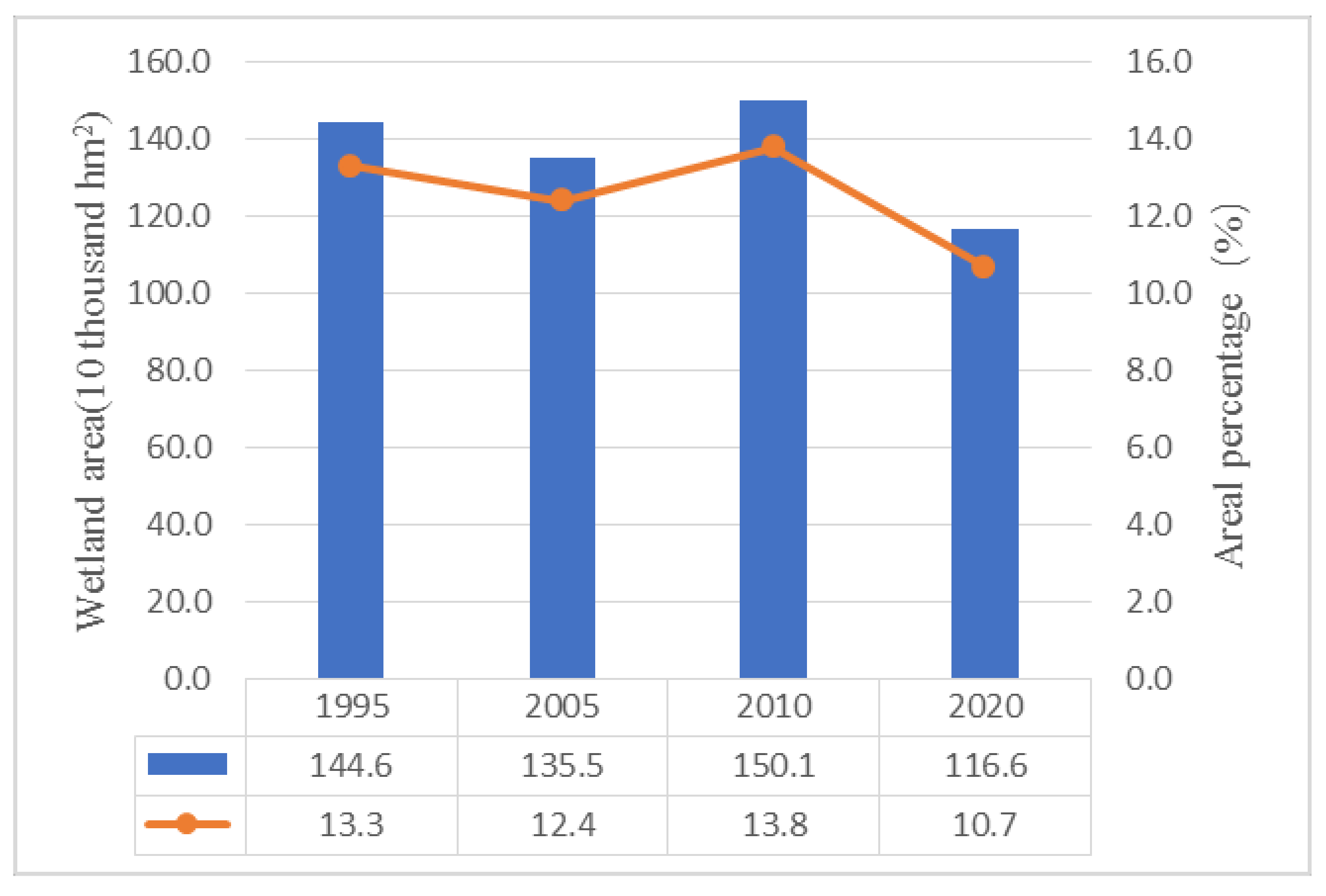
4.1. Policy Stage Division and Their Characteristics

The kappa coefficients between the predicted results and the actual land use status at intervals of five years starting from 1995 are presented in Table 1.
The land use result for 2005 was predicted based on the data from 1995 to 2000, and when compared with the actual status in 2005, the kappa coefficient was 0.97; this is very close to 1, indicating that the predicted result was largely in line with the actual state. Hence, the land use policy from 1995 to 2005 was consistent; between 2000 and 2005, the kappa coefficient between the predicted land use outcome in 2010 and the actual land use in 2010 was 0.85. Although this fulfilled the consistency requirement, when compared with the previous prediction, the consistency was significantly reduced, suggesting that the land use pattern from 2000 to 2005 was different from that from 2005 to 2010; therefore, 2005 was identified as a node experiencing a change in policy. From 2005 to 2010, the kappa coefficient between the predicted land use outcome in 2015 and the actual land use in 2015 was 0.90, which was also lower than the kappa coefficient for other time periods. Thus, 2010 was also determined as a policy change node. From 2010 to 2015, the kappa coefficient between the predicted land use outcome in 2020 and the actual land use in 2020 was 0.95, showing a relatively high level of consistency. Therefore, the land use policy from 2010 to 2020 was consistent. Overall, 2005 and 2010 were the main two policy change nodes since 1995. Thus, based on the variation in the kappa coefficients between the land use predictions every five years and the actual land use validations, the different land use policy change nodes were determined, and these 25 years were divided into three policy stages (PS1, PS2, PS3), namely 1995–2005, 2005–2010, and 2010–2020.

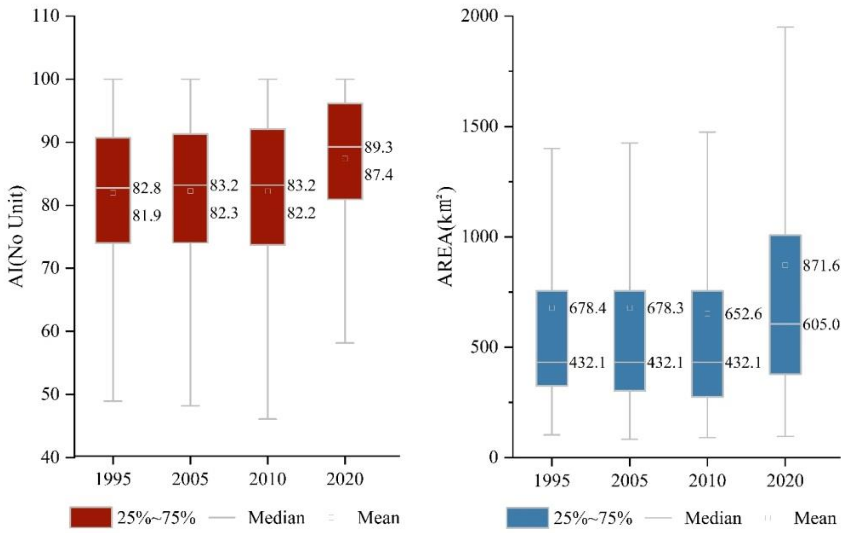
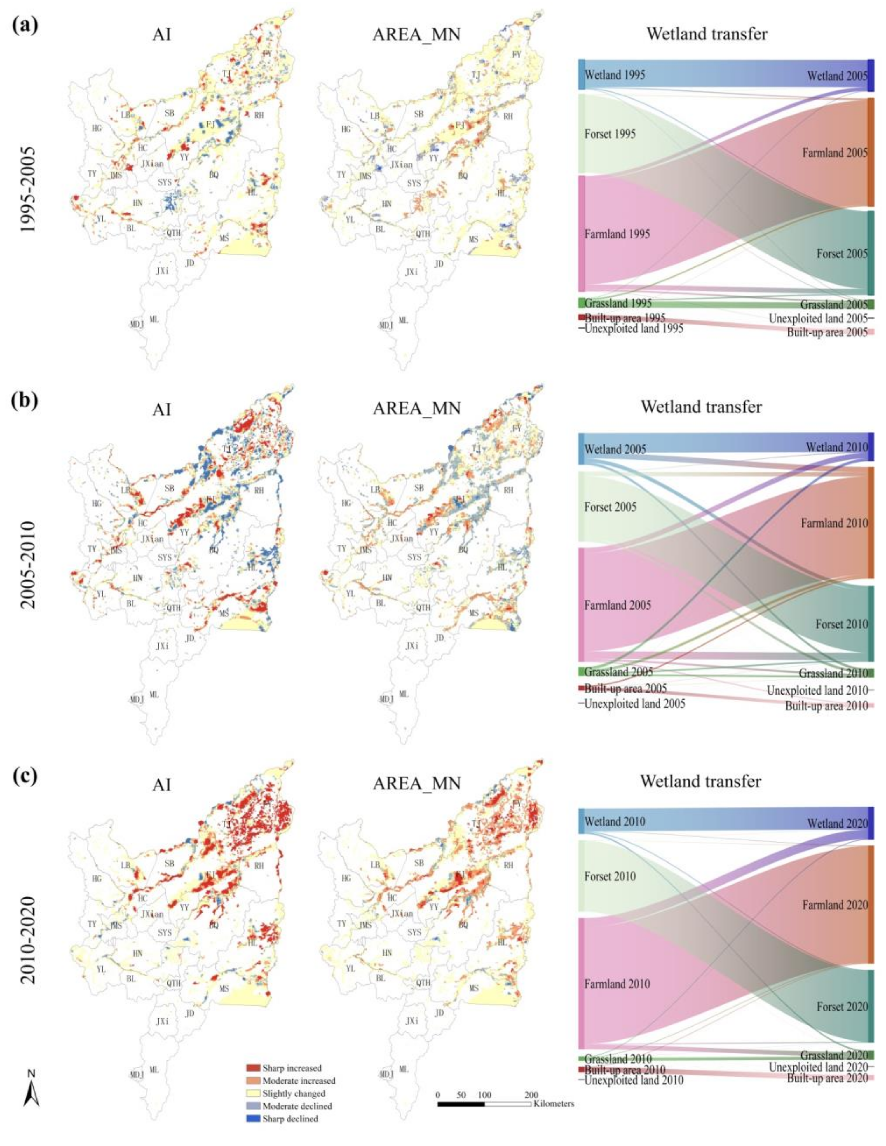
4.2. Change Characteristics of Wetland Pattern and Connectivity in Different Policy Stages

Through spatial analysis and calculation, the wetland area in four time periods and its proportion in the total area of the Sanjiang Plain were determined; these results are shown in Figure 2. From 1995 to 2005, the total wetland area on the Sanjiang Plain decreased by 90,900 hm2; from 2005 to 2010, it increased by 146,700 hm2; and from 2010 to 2020, it decreased by 335,400 hm2. In the three policy stages, the change in wetland area shows a trend of first decreasing, then increasing to the former area, and then decreasing with a large area. From the perspective of spatial changes, in 2005–2010, the central part was reclaimed, and the wetland in the eastern area disappeared, and in 2010–2020, the central area basically remained unchanged, and the northeastern area was completely reclaimed.
The characteristics of PS1 (1995–2005): The decrease in wetland area is relatively small, mostly being converted to farmland. The hydrological connectivity structure is reduced, but the average patch area changes little (Figure 3). In this PS1 period, the wetland area only decreased by 8.07%, of which 3.41% was converted to farmland (Figure 4a). For the hydrological connectivity, 3.24% of the wetland was severely reduced and 12.82% reduced to a certain degree. For the average patch area, 14.36% of the wetland decreased below 1000 square meters (Figure 5). The areas with reduced hydrological connectivity are mainly concentrated in the northeastern part of the Sanjiang Plain, and there are also scattered distributions in Tongjiang City, Fuyuan City and Hulin City; the areas with a decreased average patch area are scattered in the central part of the Sanjiang Plain (Figure 4a).
The characteristics of stage PS2 (2005–2010): The increase in wetland area is large, mostly being converted from farmland. The hydrological connectivity structure is greatly reduced, and the average patch area is also greatly reduced (Figure 3). In the PS2 period, the wetland area increased by 38.22%, of which 17.55% was converted to farmland (Figure 4b). For the hydrological connectivity, 12.49% of the wetland was severely reduced and 20.04% reduced to a certain degree. For the average patch area, 2.59% of the wetland decreased more than 1000 square meters, and 30.26% decreased less than 1000 square meters (Figure 5). The areas with reduced hydrological connectivity are mainly concentrated in the eastern and northeastern parts of the Sanjiang Plain, and there are also scattered distributions in Tongjiang City, Fuyuan City and Hulin City; the areas with a decreased average patch area are scattered in the central and eastern parts of the Sanjiang Plain (Figure 4b).
The characteristics of stage PS3 (2010–2020): The wetland area remains basically unchanged, the transfer in and out is basically balanced, the hydrological connectivity structure is greatly increased, and the average patch area is also greatly increased (Figure 3). In the PS3 period, the wetland area decreased by 11.35%, of which 1.65% was converted to farmland (Figure 4c). In total, 1.34% of the wetland hydrological connectivity was severely reduced, while 6.78% experienced some reduction in hydrological connectivity. The decrease in the average area of plaques within 0.82% of the wetland is above 1000 square meters, and 6.02% is below 1000 square meters (Figure 5). The areas with reduced hydrological connectivity are distributed in accordance with the areas with a decreased average patch area, which are scattered in most areas in the northeast of the Sanjiang Plain, in the southeast and in some areas in the northwest (Figure 4c).

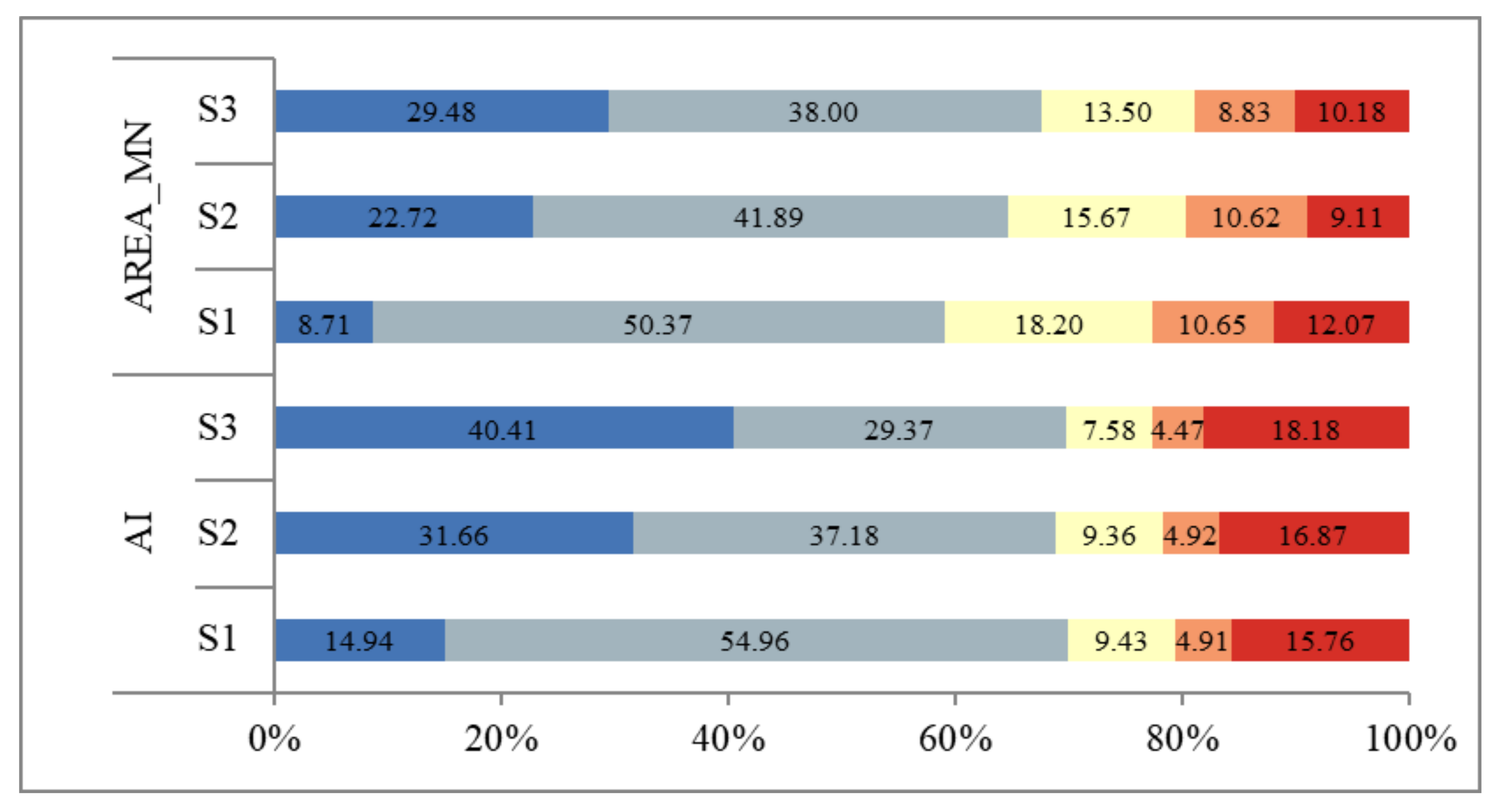
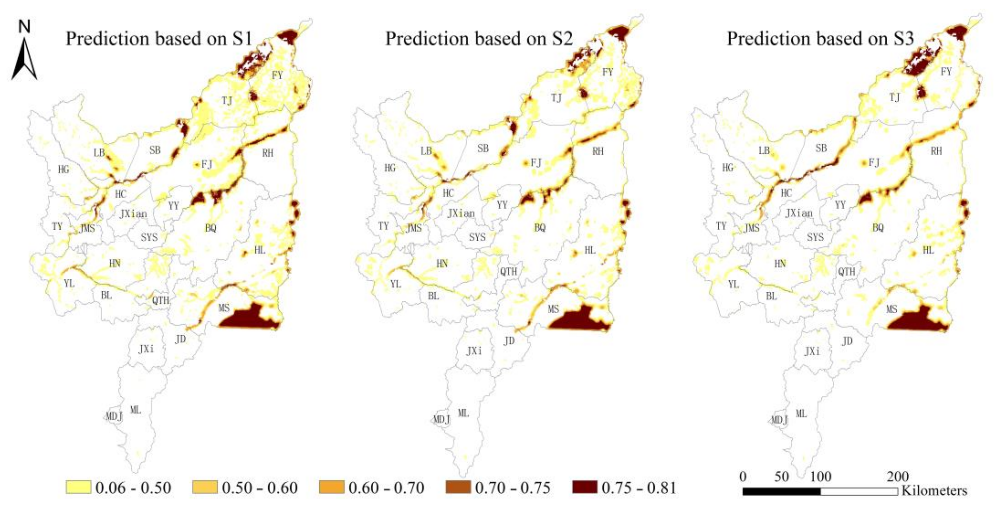
4.3. Prediction of Wetland Biodiversity in Different Scenarios

AI and AREA-MN are the main indicators used to predict wetland biodiversity patterns. They are the critical factors causing changes in wetland biodiversity patterns. We divide these two indicators into five levels (sharp decline, moderate decline, slight change, moderate increase and sharp increase) to illustrate the changes in AI and AREA-MN. In the scenarios of S1, S2, and S3, the areas with different levels tend to show a sharp increase in the level of decline and a great decrease in moderate decline, while the other levels remain unchanged (Figure 6). The proportions of a sharp decline in AI are 14.94%, 31.66%, and 40.41%, respectively, while the proportions of a moderate declined in AI are 54.59%, 37.18%, and 29.37%, respectively. Spatially, the areas of AI with high connectivity are mainly distributed in the confluence area of the rivers in Tongjiang City and Fuyuan City, as well as in the riparian zone of the Songhua River in the Suibin section (Figure 7a). The predicted sharp decline in AREA_MN areas shows an increasing trend; the areas with a moderate decline show a significant decline; the areas with a slightly changed and moderately increased level show a slight decline; and the areas with a sharply increased level first decrease and then increase (Figure 6). Spatially, the areas with high AREA_MN are mainly consistent with that of AI (Figure 7b).
If developed according to the land use policy from 1995 to 2005 (S1), by 2030, regions with a medium or above level of biodiversity will account for 25.11% of the original wetland area (the wetland area in 1995); if developed according to the land use policy from 2005 to 2010 (S2), by 2030, regions with a medium or above level of biodiversity on the Sanjiang Plain will account for 21.67% of the original wetland area; and if developed according to the land use policy from 2010 to 2020 (S3), by 2030, regions with a medium or above level of biodiversity on the Sanjiang Plain will account for 21.34% of the original wetland area (Figure 8a). The predicted numerical value of the biodiversity conservation of S1, S2, and S3 increases successively as a whole. Among them, more than 25% of the wetlands in S3 have a biodiversity conservation value exceeding 0.65 (Figure 8b). In comparison with S1 and S2, in the riverside zone between the river confluence area of Fuyuan City and the Suibin section of the Songhua River, S3 exhibited a relatively higher level of biodiversity, whereas the biodiversity level in the wetland distribution area on both sides of the river in Fujin City and Mishan City was relatively low (Figure 9).

5. Discussion

This study aimed to address the scarcity of wetland biodiversity prediction studies at the regional scale and the lack of policy linkage. It intended to make use of the CA-Markov model and the BEHPC model, and integrate land use policies into the simulation and prediction of wetland biodiversity patterns to provide a reference for quantifying and assessing the impact of land use policies on wetland biodiversity patterns and the judgment of future development trends. This study has confirmed the usability of the CA-Markov model in identifying policy change nodes. By combining it with the BEHPC model, it is possible to predict the wetland biodiversity pattern. The results show that the Sanjiang Plain has experienced three stages of land use and wetland protection policy changes, and that the policy in the period from 2010 to 2020 was most conducive to the improvement of the regional wetland biodiversity conservation value. This study not only provides technological support for the evaluation of wetland biodiversity-related policies at the regional scale, but also has implications for the protection and restoration of wetlands.
The test results regarding the consistency between the predictions in each stage and the actual land use status show that the kappa coefficients are 0.97, 0.85, 0.90, and 0.95 respectively. Although the test coefficients meet the consistency standards, the obvious low values indicate that there are differences in land use policies between these two time nodes. From the perspective of actual policy changes over time, during 1995–2005, in the context of the implementation of the “ Biodiversity Conservation Action Plan of China”, the “Regulations on Wetland Protection in Heilongjiang Province”, the policy proposal of returning farmland to wetland [45], and the approval of the “National Project Plan of Wetland Protection (2002–2030)” (2003) [46], the decrease in wetland resources on the Sanjiang Plain has slowed down. From 2005 to 2010, according to the “Implementation Plan of the National Wetland Protection Project (2005–2010) [47,48], a large number of wetland protection projects have been implemented on the Sanjiang Plain, and the wetland protection system has been further improved [49,50,51,52]. A series of wetland restoration technologies have been developed [53,54,55]. Furthermore, important wetlands have received protection and the wetland protection management capacity has been significantly enhanced. From 2010 to 2020, 77 wetland parks, 87 provincial-level and above wetland-type nature reserves, and 9 wetland protection areas in the Sanjiang Plain were included in the wetland protection system [56], and each reserve has launched a large number of projects that aim to return farmland to wetland and perform wetland restoration. From 2014 to 2020, Heilongjiang Province has cumulatively returned 32,726.66 hm2 of farmland to wetland, accounting for 30.02% of the total area of farmland returned to wetland in China [57]. The implementation of the above policies has obvious time stages, and these are basically consistent with the time nodes identified in this study. In previous studies, the CA-Markov model was mostly used to verify the consistency between the predicted future land use and the actual land use status [38]. This study expands the application scope and uses it to identify the time nodes of policy changes. By comparing the research results with the actual implementation years of policies, it has also confirmed the reliability of this model for identifying policy changes.
The changes in wetland area, structure, etc., in different land use policy stages show that although the total wetland area was reduced to its lowest in 2020 (Figure 2), the numerical values of wetland pattern and connectivity indicators (AI and AREA_MN) have increased (Figure 3), indicating that the land use policy from 2010 to 2020 improved the quality of the wetland itself. In the policy stages of PS1, PS2, and PS3, the reduced levels (sharp declined and moderate declined) of AI and AREA_MN first increased and then decreased, while the increased levels (sharp increased and moderate increased) gradually increased (Figure 5). They also indicated that the policies implemented in each stage are gradually getting better, and that the aggregation and average area of wetlands within a certain range have been restored to a certain extent. For example, establishing protected areas in important wetlands and implementing the policy of returning farmland to wetland [58,59] are all good measures able to optimize the structure of wetlands within a certain range and enhance the function and quality of wetlands. The alterations during the PS2 stage are rather distinctive. While the wetland pattern and connectivity indexes declined, the wetland area actually increased. The sharp and moderate decline in the levels of AI escalated to approximately 33% during this period, signifying that the land use policy at this time was not conducive to the enhancement of the pattern structure, functions, and quality of wetlands. This resulted in the “Urgent Notice of the General Office of the State Council for the Earliest Resumption of the Production of Abandoned Cultivated Land” issued by the General Office of the State Council and the tax exemption and subsidy policies carried out for a multitude of farmers [60,61], which led to the renewed large-scale development of wetlands on the Sanjiang Plain. Irregular and unscientific development has caused damage to the structure and functions of wetlands. Nevertheless, there were sharp and moderate increased levels during the PS2 stage compared to the PS1. This outcome was generated, on the one hand, by the reinforcement of some wetland protection and management strategies, and on the other hand, might have been influenced by the relatively high rainfall in that year [62,63]; this ultimately reveals the increasing wetland area. In general, in different time periods, the alteration of wetlands on the Sanjiang Plain under the dual influence of strengthening protection and reclamation is exceedingly complex.
Based on the development characteristics in the PS1, PS2, and PS3 stages, the predicted scenarios (S1, S2 and S3) of wetland biodiversity reveal that the proportion of areas with an above average biodiversity is 25.11%, 21.67%, and 21.34%, respectively, while the average values of biodiversity conservation are 0.42, 0.45, and 0.49 (Figure 8a,b). This indicates that regardless of which land use policy is followed for development, areas with a relatively high wetland biodiversity in the Sanjiang Plain will decrease. However, the conservation value of the development model in the later stages (S2 and S3) will be higher than that of the development model in the earlier stage (S1), and the S3 development model is the most conducive to enhancing the wetland biodiversity conservation value. It is proven that the comprehensive effect of China’s current basic farmland protection and biodiversity protection network, returning farmland to wetland, and other land use and wetland protection policies could improve the value of wetland biodiversity conservation in the future. Thus, it can be seen that strengthening the current land use and wetland protection policies, ensuring the implementation and effective operation of various policies, and implementing protection and restoration projects are critical to enhancing future wetland biodiversity in the region. In this process, nature reserves play an irreplaceable role in wetland biodiversity protection and improvement [64,65].
Land use and wetland protection policies play an important guiding role in rational land use and the maintenance of sustainable development [66,67]. Land use and wetland protection policies in different periods show different effects on wetland protection. Adjusting policies in a timely manner according to historical change characteristics and the prediction of future conservation value to make them increasingly beneficial to wetland resource protection and regional sustainable development is crucial to connecting policies with actual protection actions. The comprehensive framework integrating stage division, stage characteristic identification and biodiversity prediction proposed in this study has the potential to provide technical support for the evaluation and adjustment of land use and wetland protection policies for other wetland systems in China or worldwide. This framework can be connected to China’s wetland biodiversity conservation system by identifying areas that are at risk of biodiversity reduction and by implementing timely measures to prevent the wetland diversity loss caused by unreasonable land use. The results of the biodiversity prediction can also provide spatial and numerical references for future policy adjustments. By identifying areas with declining biodiversity, it is possible to implementing preventive measures, including increasing the aggregation of wetland patches and increasing the average patch area within a certain range. For areas with increasing biodiversity, we suggest the expansion of protected areas.
There are inevitably some uncertainties in the study, such as errors in remote sensing image interpretation, interference from abnormal rainfall, etc. [68,69]. In future studies, the interpretation of remote sensing images should be updated to improve the accuracy of interpretation as much as possible, eliminate climate interference, and optimize the prediction results regarding wetland biodiversity and its related simulation indicators. It is worth noting that the policy evaluation and biodiversity prediction conducted in this study only consider the existing wetlands; however, it remains undetermined exactly how many wetlands should be protected and what exact structural indicators should be considered in order to maintain the function of wetlands on the Sanjiang Plain. These issues need to be studied further in the future.

6. Conclusions

The objective of this study was to propose a comprehensive framework that integrates policy stage division, the identification of stage characteristics, and future biodiversity prediction to provide robust technical support and a reference for the assessment and adjustment of regional land use and wetland protection policies. Currently, there are relatively few studies on the prediction of wetland biodiversity patterns, and studies on the connection between land use and wetland protection policies are notably lacking. This study addressed these two aspects by incorporating land use and wetland conservation policies into the prediction of wetland biodiversity patterns through the utilization of the CA-Markov model, which was used to divide the stages of historical policies and was combined with the BEHPC model to predict future wetland biodiversity patterns. The research results strongly confirm that policy stage division can be accomplished effectively through time-series simulation and verification, and that combining these two models enables the precise prediction of wetland biodiversity patterns. The land use and wetland protection policies employed on the Sanjiang Plain between 2010 and 2020 are the ones that are most advantageous to the promotion of wetland biodiversity.
At present, the impact of regional-scale land use and wetland protection policies on the wetland biodiversity pattern has not been thoroughly explored. This article offers a comprehensive framework for the evaluation of land use and wetland protection policies at the regional scale and the prediction of changes in the pattern of biodiversity, contributing to theory and methodology. By reviewing land use prediction and wetland biodiversity simulation prediction methods, we have provided insights into the integrated research of policy evaluation and biodiversity pattern prediction. Additionally, by integrating land use prediction models and biodiversity simulation methods based on wetland pattern and connectivity, we have proposed wetland biodiversity pattern prediction scenarios under different stages of policy development models, which holds significant practical significance. This study not only provides a crucial technical framework for the assessment of wetland-related policies at the regional scale in the future, but also offers valuable scheme references in terms of spatial structure optimization and numerical goals for future policy adjustments.

Author Contributions

Conceptualization, Y.Q. and N.X.; methodology, Y.Q.; software, H.L. and B.Z.; validation, Y.W., W.G. and R.W.; formal analysis, X.Z. and H.Z.; investigation, L.C. and R.W.; resources, N.X.; data curation, C.L.; writing—original draft preparation, L.C., Y.Q. and N.X.; writing—review and editing, Y.Q.; visualization, L.C.; supervision, N.X.; project administration, Y.Q.; funding acquisition, Y.Q. and L.C. All authors have read and agreed to the published version of the manuscript.

Funding

This research was funded by the National Natural Science Foundation of China (grant number: 42371287), the Provincial Research Funds of the Institutes of Heilongjiang Province (grant number: ZNJCB2023ZR04, CZKYF2023-1-C023, ZNBZ2022ZR05). Scientific Research Fund of Heilongjiang Academy of Sciences (grant number: KY2023ZR02).

Data Availability Statement

The data that support the findings of this study are available from the corresponding author upon reasonable request.

Acknowledgments

We thank the Resource and Environment Data Cloud Platform and the National Fundamental Geographic Information System for the provided the data set. We also appreciate the extra survey data collected from the projects that fund this research.

Conflicts of Interest

The authors declare no conflicts of interest.

References

  1. Mahdian, M.; Noori, R.; Salamattalab, M.M.; Heggy, E.; Bateni, S.M.; Nohegar, A.; Hosseinzadeh, M.; Siadatmousavi, S.M.; Fadaei, M.R.; Abolfathi, S. Anzali Wetland Crisis: Unraveling the Decline of Iran’s Ecological Gem. J. Geophys. Res.-Atmos. J. 2024, 129, 4. [Google Scholar] [CrossRef]
  2. Hidalgo-Corrotea, C.; Alaniz, A.J.; Vergara, P.M.; Moreira-Arce, D.; Carvajal, M.A.; Pacheco-Cancino, P.; Espinosa, A. High vulnerability of coastal wetlands in Chile at multiple scales derived from climate change, urbanization, and exotic forest plantations. Sci. Total Environ. 2023, 903, 166130. [Google Scholar] [CrossRef] [PubMed]
  3. Asongwe, G.A.; Bame, I.B.; Ndam, L.M.; Orock, A.E.; Tellen, V.A.; Bumtu, K.P.; Tening, A.S. Influence of urbanisation on phytodiversity and some soil properties in riverine wetlands of Bamenda municipality. Cameroon Sci. Rep. 2022, 12, 19766. [Google Scholar] [CrossRef]
  4. Huggins, X.; Gleeson, T.; Kummu, M.; Zipper, S.C.; Wada, Y.; Troy, T.J.; Famiglietti, J.S. Hotspots for social and ecological impacts from freshwater stress and storage loss. Nat. Commun. 2022, 13, 439. [Google Scholar] [CrossRef] [PubMed]
  5. Newton, A.; Icely, J.; Cristina, S.; Perillo, G.M.; Turner, R.E.; Ashan, D.; Cragg, S.; Luo, Y.; Tu, C.; Li, Y.; et al. Anthropogenic, direct pressures on coastal wetlands. Front. Ecol. Evol. 2020, 8, 144. [Google Scholar] [CrossRef]
  6. Moi, D.A.; Lansac-Tôha, F.M.; Romero, G.Q.; Sobral-Souza, T.; Cardinale, B.J.; Kratina, P.; Perkins, D.M.; de Mello, F.T.; Jeppesen, E.; Heino, J.; et al. Human pressure drives biodiversity-multifunctionality relationships in large Neotropical wetlands. Nat. Ecol. Evol. 2022, 6, 1279–1289. [Google Scholar] [CrossRef]
  7. Zhong, Y.H.; Xue, Z.S.; Davis, C.C.; Moreno-Mateos, D.; Jiang, M.; Liu, B.; Wang, G. Shrinking habitats and native species loss under climate change: A multifactorial risk assessment of China’s inland wetlands. Earth’s Future 2022, 10, e2021EF002630. [Google Scholar] [CrossRef]
  8. Fluet-Chouinard, E.; Stocker, B.D.; Zhang, Z.; Malhotra, A.; Melton, J.R.; Poulter, B.; Kaplan, J.O.; Goldewijk, K.K.; Siebert, S.; Minayeva, T.; et al. Extensive global wetland loss over the past three centuries. Nature 2023, 614, 281–286. [Google Scholar] [CrossRef]
  9. Deane, D.C.; Fordham, D.A.; He, F.L.; Bradshaw, C.J. Future extinction risk of wetland plants is higher from individual patch loss than total area reduction. Biol. Conserv. 2017, 209, 27–33. [Google Scholar] [CrossRef]
  10. Ray, A.M.; Gould, W.R.; Hossack, B.R.; Sepulveda, A.J.; Thoma, D.P.; Patla, D.A.; Daley, R.; Al-Chokhachy, R. Influence of climate drivers on colonization and extinction dynamics of wetland-dependent species. Biol. (Gen.) Ecol. 2016, 7, 2150–8925. [Google Scholar] [CrossRef]
  11. Qu, Y.; Gong, H.X.; Zheng, Y.M.; Shi, J.; Zeng, X.; Yang, H.; Wang, J.; Niu, Z.; Li, L.; Wang, S.; et al. Global conservation priorities for wetlands and setting post-2025 targets. Commun. Earth Environ. 2024, 5, 4. [Google Scholar]
  12. Qu, Y.; Luo, C.Y.; Zhang, H.Q.; Zeng, X.Y.; Li, H.; Ni, H. Prioritization of wetland restoration in Sanjiang Plain, based on historical biodiversity and landscape structure. Acta Ecol. Sin. 2018, 38, 5709–5716. [Google Scholar]
  13. Jantke, K.; Schneider, U.A. Multiple-species conservation planning for European wetlands with different degrees of coordination. Biol. Conserv. 2010, 143, 1812–1821. [Google Scholar] [CrossRef]
  14. Schleupner, C.; Schneider, U.A. GIS-based estimation of wetland conservation potentials in Europe. Appl. Ecol. Environ. Res. 2012, 10, 385–403. [Google Scholar] [CrossRef]
  15. Kingsford, R.T.; Brandis, K.; Thomas, R.F.; Crighton, P.; Knowles, E.; Gale, E. Classifying landform at broad spatial scales: The distribution and conservation of wetlands in New South Wales, Australia. Mar. Freshw. Res. 2004, 55, 17–31. [Google Scholar] [CrossRef]
  16. Bellio, M.; Kingsford, R.T. Alteration of wetland hydrology in coastal lagoons: Implications for shorebird conservation and wetland restoration at a Ramsar site in Sri Lanka. Biol. Conserv. 2013, 167, 57–68. [Google Scholar] [CrossRef]
  17. Kingsford, R.T.; Biggs, H.C.; Pollard, S.R. Strategic adaptive management in freshwater protected areas and their rivers. Biol. Conserv. 2011, 144, 1194–1203. [Google Scholar] [CrossRef]
  18. Beroho, M.; Briak, H.; Cherif, E.K.; Boulahfa, I.; Ouallali, A.; Mrabet, R.; Kebede, F.; Bernardino, A.; Aboumaria, K. Future scenarios of land-use/land cover (LULC) based on a CA-Markov simulation model: Case of a mediterranean watershed in morocco. Remote Sens. 2023, 15, 1162. [Google Scholar] [CrossRef]
  19. Qu, Y.; Zheng, Y.M.; Gong, P.; Shi, J.; Li, L.; Wang, S.; Luo, C.; Zhang, H.; Xu, L. Estimation of wetland biodiversity based on the hydrological patterns and connectivity and its potential application in change detection and monitoring: A case study of the Sanjiang Plain, China. Sci. Total Environ. 2022, 805, 150291. [Google Scholar] [CrossRef]
  20. Sangermano, F.; Pontius, R.G.; Chaitman, J.; Meneghini, A. Linking land change model evaluation to model objective for the assessment of land cover change impacts on biodiversity. Landsc. Ecol. 2021, 36, 2707–2723. [Google Scholar] [CrossRef]
  21. Kundu, S.; Khare, D.; Mondal, A. Landuse change impact on sub-watersheds prioritization by analytical hierarchy process (AHP). Ecol. Inform. 2017, 42, 100–113. [Google Scholar] [CrossRef]
  22. Eppink, F.V.; Van den Bergh, J.C.J.M.; Rietveld, P. Modelling biodiversity and land-use: Urban growth, agriculture and nature in a wetland area. Ecol. Econ. 2004, 51, 201–216. [Google Scholar] [CrossRef]
  23. El-Alfy, M.A.; Elfanagily, B.A.; Zyadah, M.A.; El-Emam, D.A. CA-Markov chain for simulation and prediction of LULC and assessing the status of water pollution in Manzala Lake after recent development. J. Coast. Conserv. 2024, 28, 4. [Google Scholar] [CrossRef]
  24. Abijith, D.; Saravanan, S. Assessment of land-use and land cover change detection and prediction using remote sensing and CA Markov in the northern coastal districts of Tamil Nadu, India. Environ. Sci. Pollut. Res. 2022, 29, 86055–86067. [Google Scholar] [CrossRef]
  25. Rahnama, M.R. Forecasting land-use changes in Mashhad Metropolitan area using Cellular Automata and Markov chain model for 2016-2030. Sustain. Cities Soc. 2021, 64, 102548. [Google Scholar] [CrossRef]
  26. Tariq, A.; Shu, H. CA-Markov chain analysis of seasonal land surface temperature and land-use land cover change using optical multi-temporal satellite data of Faisalabad, Pakistan. Remote Sens. 2020, 12, 3402. [Google Scholar] [CrossRef]
  27. Yirsaw, E.; Nigussie, W. Land-use/land cover change modeling and evaluating the spatiotemporal dynamics of highland bamboo species in the Southern Highland of Ethiopia. J. Indian Soc. Remote Sens. 2024, 52, 63–77. [Google Scholar] [CrossRef]
  28. Janizadeh, S.; Pal, S.C.; Saha, A.; Chowdhuri, I.; Ahmadi, K.; Mirzaei, S.; Mosavi, A.H.; Tiefenbacher, J.P. Mapping the spatial and temporal variability of flood hazard affected by climate and land-use changes in the future. J. Environ. Manag. 2021, 298, 113551. [Google Scholar] [CrossRef]
  29. Faichia, C.; Tong, Z.J.; Zhang, J.Q.; Liu, X.P.; Kazuva, E.; Ullah, K.; Al-Shaibah, B. Using RS data-based CA-Markov model for dynamic simulation of historical and future LUCC in Vientiane, Laos. Sustainability 2020, 12, 8410. [Google Scholar] [CrossRef]
  30. Mumtaz, F.; Tao, Y.; de Leeuw, G.; Zhao, L.; Fan, C.; Elnashar, A.; Bashir, B.; Wang, G.; Li, L.; Naeem, S.; et al. Modeling spatio-temporal land transformation and its associated impacts on land surface temperature (LST). Remote Sens. 2020, 12, 2987. [Google Scholar] [CrossRef]
  31. Rahimi, L.; Malekmohammadi, B.; Yavari, A.R. Assessing and modeling the impacts of wetland land cover changes on water provision and habitat quality ecosystem services. Nat. Resour. Res. 2020, 29, 3701–3718. [Google Scholar]
  32. Lu, L.L.; Salman, Q.S.; Li, Q.T.; Chen, F.; Shu, L. Monitoring and projecting sustainable transitions in urban land-use using remote sensing and scenario-based modelling in a coastal megacity. Ocean Coast. Manag. 2022, 224, 106201. [Google Scholar]
  33. Qu, Y.; Zeng, X.Y.; Luo, C.Y.; Zhang, H.; Ni, H. Prediction of wetland biodiversity pattern under the current land-use mode and wetland sustainable management in Sanjiang Plain, China. Ecol. Indic. 2023, 147, 109990. [Google Scholar]
  34. Xu, N.; Cui, L.; Zeng, X.Y.; Zhang, H.; Li, H.; Zhou, B.; Luo, C.; Wu, R. Wetland Distribution Prediction Based on CA-Markov Model under Current Land-use and Protection Policy in Sanjiang Plain. Sustainability 2024, 16, 5750. [Google Scholar] [CrossRef]
  35. Zhang, J.Y.; Ma, K.M.; Fu, B.J. Wetland loss under the impact of agricultural development in the Sanjiang Plain. NE China. Environ. Monit. Assess. 2010, 166, 139–148. [Google Scholar] [PubMed]
  36. Pinto-Cruz, M.C. A modified transfer matrix method for static and dynamic analysis of beams that eliminates the need to compute the inverse of the zero matrix. Iran. J. Sci. Technol.-Trans. Civ. Eng. 2024, 48, 2875–2890. [Google Scholar] [CrossRef]
  37. Behera, M.D.; Chitale, V.S.; Shaw, A.; Roy, P.S.; Murthy, M.S.R. Wetland monitoring, serving as an index of land-use change—A study in samaspur wetlands, Uttar Pradesh, India. J. Indian Soc. Remote Sens. 2012, 40, 287–297. [Google Scholar]
  38. Zhu, C.J.; Tian, B.; Zhou, Y.X.; Fan, Z.Q. Wetland change analysis and forecasting in Pudong new area using Markov and CLUE-S mode. J. Fudan Univ. Nat. Sci. 2015, 54, 431–438+448. [Google Scholar]
  39. Margules, C.R.; Pressey, R.L. Systematic conservation planning. Nature 2000, 405, 243–253. [Google Scholar] [CrossRef]
  40. Qu, Y.; Sun, G.Q.; Luo, C.Y.; Zeng, X.; Zhang, H.; Murray, N.J.; Xu, N. Identifying restoration priorities for wetlands based on historical distributions of biodiversity features and restoration suitability. J. Environ. Manag. 2019, 231, 1222–1231. [Google Scholar]
  41. Amir, S.M.; Wang, Y.; Xu, N.; Ullah, N.; Zeng, P. The spatiotemporal implications of urbanization for urban heat islands in Beijing: A predictive approach based on CA-Markov modeling (2004–2050). Remote Sens. 2021, 13, 4697. [Google Scholar] [CrossRef]
  42. Koko, A.F.; Yue, W.; Abubakar, G.A.; Hamed, R.; Alabsi, A.A.N. Monitoring and predicting spatio-temporal land-use/land cover changes in Zaria city, Nigeria, through an integrated cellular automata and Markov chain model (CA-Markov). Sustainability 2020, 12, 10452. [Google Scholar] [CrossRef]
  43. Hu, X.; Li, X.; Lu, L. Modeling the land-use change in an arid oasis constrained by water resources and environmental policy change using cellular automata models. Sustainability 2018, 10, 2878. [Google Scholar] [CrossRef]
  44. Liu, Y. Study on Climatic and Hydrological Effects and Scenarios Simulation of Spatio-Temporal Change of Wetlands in Western Jilin Province. Ph.D. Thesis, Northeast Normal University, Changchun, China, 2015. (In Chinese). [Google Scholar]
  45. Liu, J.P.; Zhao, D.D.; Tian, X.Z. Dynamic change and driving force of land-use landscape pattern in Sanjiang Plain from 1954 to 2010. Acta Ecol. Sin. 2014, 34, 3234–3244. [Google Scholar]
  46. He, X.Y.; Jia, M.M.; Wang, Z.M.; Ren, C.; Zheng, H.; Guo, Y.; Zhang, X.; Xin, X. Remote Sensing based evaluation of effectiveness of wetland protection project in Sanjiang Plain, China. Assess. Eff. Natl. Ecol. Conserv. Restor. Proj. 2017, 32, 3–10. (In Chinese) [Google Scholar]
  47. He, G.Y. Analysis of Local Wetland Protection Legislation and Norms in China—Based on the Perspective of the Development and Improvement of Environmental and Law; Chinese Society of Environment and Resources Law (CSERL): Beijing, China, 2016; pp. 25–33. [Google Scholar]
  48. NFGA (National Forestry and Grassland Administration). <<National Wetland Conservation Project Implementation Plan >>(2005–2010); National Forestry and Grassland Administration: Beijing, China, 2005. [Google Scholar]
  49. Qiu, Z.Q.; Luo, L.; Mao, D.H.; Du, B.; Feng, K.; Jia, M.; Wang, Z. Using multisource geospatial data to identify potential wetland rehabilitation areas: A pilot study in China’s Sanjiang Plain. Water 2020, 12, 2496. [Google Scholar] [CrossRef]
  50. Du, B.J.; Zheng, Y.Y.; Liu, J.P.; Mao, D. Threatened plants in China’s Sanjiang Plain: Hotspot distributions and gap analysis. Sustainability 2018, 10, 194. [Google Scholar] [CrossRef]
  51. Liu, J.P.; Lü, X.G. Study on the spatial pattern of wetland bird richness and hotspots in Sanjiang Plain. Acta Ecol. Sin. 2011, 31, 5894–5902. [Google Scholar]
  52. Zheng, Y.Y. GAP Analysis of Wetland Plants in the Sanjiang Plain. Master’s Thesis, Jilin Normal University, Changchun, China, 2011. [Google Scholar]
  53. Jiang, W.G.; Zhang, Z.; Ling, Z.Y.; Deng, Y. Experience and future research trends of wetland protection and restoration in China. Acta Geogr. Sin. 2023, 78, 2223–2240. [Google Scholar]
  54. Li, H.X.; Sun, X.X.; Man, X.L.; Wang, Q.B.; Li, D.; Hu, Y.L. Changes of soil heavy metal contents and pollution evaluation during the restoration of wetlands. J. Beijing For. Univ. 2020, 42, 134–142. (In Chinese) [Google Scholar]
  55. Ma, G.R. Technical Guidelines for Wetland Restoration in National Wetland Parks; China Environmental Press: Beijing, China, 2017; pp. 156–158. (In Chinese) [Google Scholar]
  56. Liu, Z.G.; Wang, Q.; Peng, A.J.; Yang, F. Conservation effect analysis of wetland Nature reserve based on PSM and DID method: A case study of Sanjiang and Naolihe National Nature Reserve in Heilongjiang Province. J. Northwest. Univ. (Nat. Sci. Ed.) 2019, 49, 54–61. (In Chinese) [Google Scholar]
  57. Cui, X.B.; Liu, M.H.; Ma, Y. Benefit analysis of the project of returning farmland to moisture in Naolihe National Nature Reserve of Heilongjiang Province. Heilongjiang Sci. 2016, 7, 153–155. (In Chinese) [Google Scholar]
  58. Ma, Z.W.; Zhang, M.X. Implementation of Wetlands Protection Law and Implementation of International Environmental Conventions in China. Nat. Prot. Areas 2022, 2, 9–16. (In Chinese) [Google Scholar]
  59. Liu, L. Research on Controversial Issues of Wetland Protection Legislation. Master’s Thesis, Beijing Jiaotong University, Beijing, China, 2021. (In Chinese). [Google Scholar]
  60. PGHP (People’s Government of Heilongjiang Province). People’s Government of Heilongjiang Province office Forwarded<<Urgent Notice of State Council Office About Fast Restore Abandonment of Cultivated Land Production >>; Gazette of the People’s Government of Heilongjiang Province: Harbin, China, 2004; Volume 8, pp. 31–32. (In Chinese) [Google Scholar]
  61. Chen, B.W. Food security: Focusing on protecting cultivated land and farmers’ enthusiasm for growing grain. Rural Econ. 2004, 12, 28–30. (In Chinese) [Google Scholar]
  62. Wang, Q.; Liu, Z.G.; Zhou, J.Y. Influencing factors and spatial effects of marsh wetland changes in the Sanjiang Plain. China Popul. Resour. Environ. 2023, 33, 44–54. (In Chinese) [Google Scholar]
  63. Li, L.; Zhang, Z.Q. Spatiotemporal variation characteristics of precipitation in the Sanjiang Plain. China Resour. Compr. Util. 2023, 41, 40–42. (In Chinese) [Google Scholar]
  64. Guo, J.H.; Zhang, Y.Q. On the enlightenment of wetland protection systems in some foreign countries to China. Ocean. Dev. Manag. 2023, 9, 55–65. [Google Scholar]
  65. Hu, P. Wetland conservation to be incorporated the normative dilemma and way out of in the nature reserve system. J. Nanjing Tech Univ. (Soc. Sci. Ed.) 2022, 21, 55–67. [Google Scholar]
  66. Keith, D.A.; Ghoraba, S.M.M.; Kaly, E.; Jones, K.R.; Oosthuizen, A.; Obura, D.; Costa, H.M.; Daniels, F.; Duarte, E.; Grantham, H.; et al. Contributions of the IUCN Red List of Ecosystems to risk-based design and management of protected and conserved areas in Africa. Conserv. Biol. 2024, 38, e14169. [Google Scholar]
  67. Urbano, F.; Viterbi, R.; Pedrotti, L.; Vettorazzo, E.; Movalli, C.; Corlatti, L. Enhancing biodiversity conservation and monitoring in protected areas through efficient data management. Environ. Monit. Assess. 2024, 196, 12. [Google Scholar]
  68. Xing, L.; Niu, Z.; Jiao, C.; Zhang, J.; Han, S.; Cheng, G.; Wu, J. A novel workflow for seasonal wetland identification using bi-weekly multiple remote sensing data. Remote Sens. 2022, 14, 1037. [Google Scholar] [CrossRef]
  69. Sangeeta, B.; Deeksha, K.; Garg, J.K. A novel strategy for wetland area extraction using multispectral MODIS data. Remote Sens. Environ. 2017, 200, 183–205. [Google Scholar]
Figure 1. The location of the study area [33].
Water 17 00859 g001
Figure 2. The wetland area and its proportion of the total area of the Sanjiang Plain from 1995 to 2020.
Water 17 00859 g002
Figure 3. Box plots of AI and AREA_MN at grid scale for the time nodes of policy changes.
Water 17 00859 g003
Figure 4. Different levels of change in AI and AREA_MN and the characteristics of wetland transfer in each policy stage.
Water 17 00859 g004
Figure 5. Percentages of AI and AREA_MN at different levels in different policy stages (the dark blue color represents a sharp decline, the light blue color represents a moderate decline, the yellow color represents a slightly changed level, the light red color represents a moderately increased level, and the dark red color represents a sharply increased level).
Water 17 00859 g005
Figure 6. Proportion of each level of AI and AREA_MN predicted in different scenarios (the dark blue color represents a sharp decline, the light blue color represents a moderate decline, the yellow color represents a slight change, the light red color represents a moderate increase, and the dark red color represents a sharp increase).
Water 17 00859 g006
Figure 7. Prediction of the spatial pattern of different AI and AREA_MN levels in different scenarios.
Water 17 00859 g007
Figure 8. Proportion of each level of predicted biodiversity under different scenarios (a) and box plot of biodiversity conservation value (b).
Water 17 00859 g008
Figure 9. Prediction of wetland biodiversity pattern under different scenarios.
Water 17 00859 g009
Table 1. Kappa coefficients of land-use status at intervals of five years from 1995 to 2020.
Beginning Time NodeEnd Time NodePrediction Time NodeKappa Coefficient
1995200020050.97
2000200520100.85
2005201020150.90
2010201520200.95
Disclaimer/Publisher’s Note: The statements, opinions and data contained in all publications are solely those of the individual author(s) and contributor(s) and not of MDPI and/or the editor(s). MDPI and/or the editor(s) disclaim responsibility for any injury to people or property resulting from any ideas, methods, instructions or products referred to in the content.

