
Study on Shallow Landslide Induced by Extreme Rainfall: A Case Study of Qichun County, Hubei, China


Abstract
1. Introduction
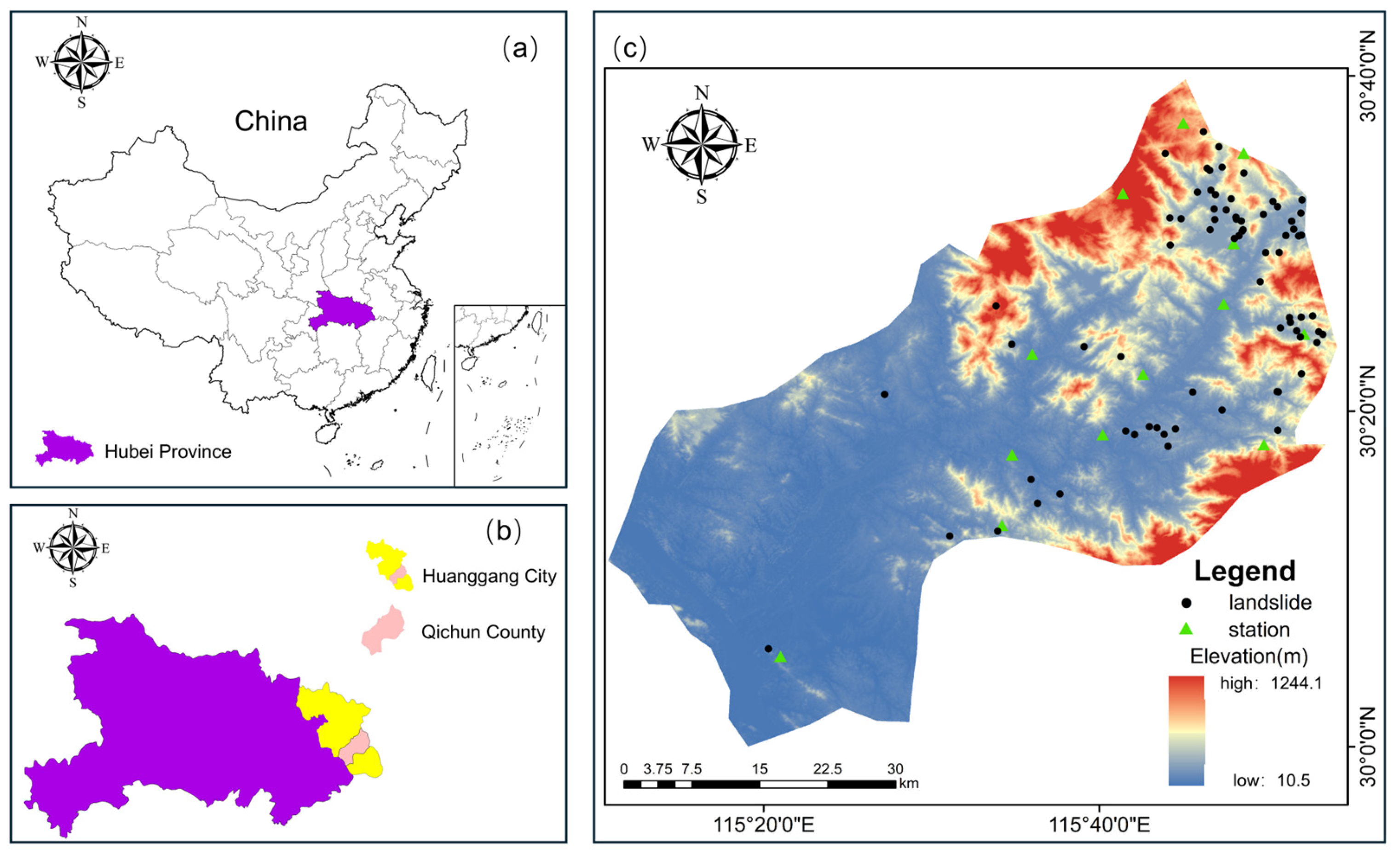
2. Study Area and Geological Environment Background
3. Materials and Methodology
3.1. Acquisition and Processing of Data
3.2. Methodology
- (1)
- Darcy’s law
- (2)
- Two-dimensional seepage differential equation
- (3)
- van Genuchten model
4. Event Description
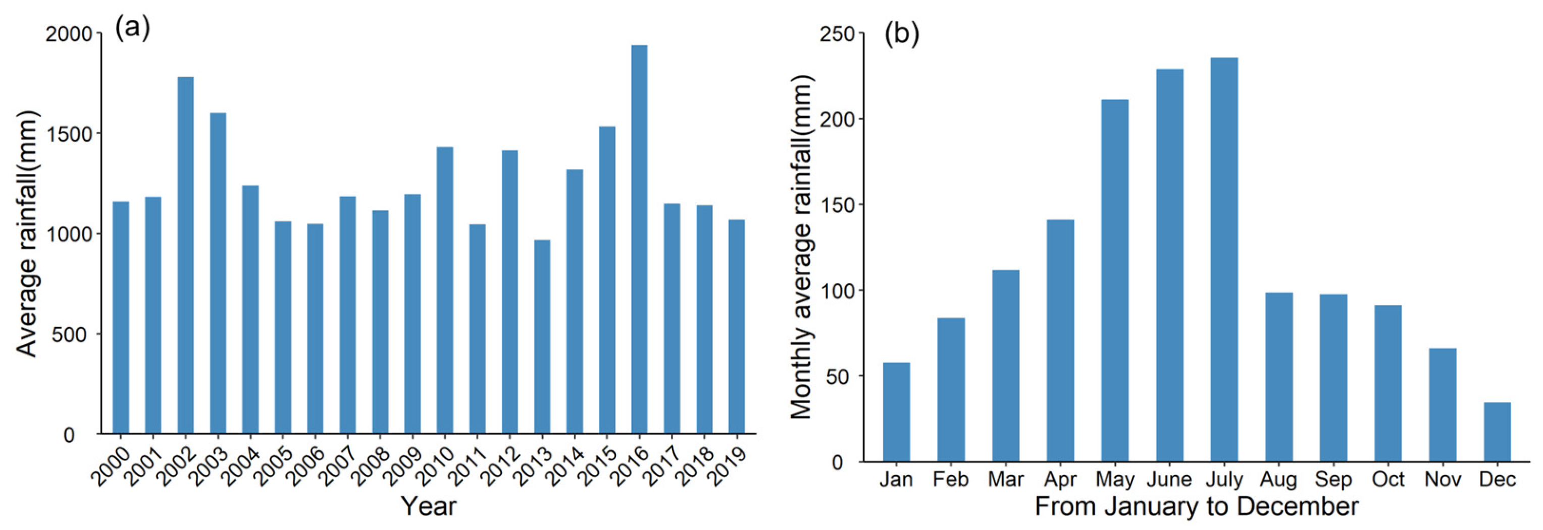
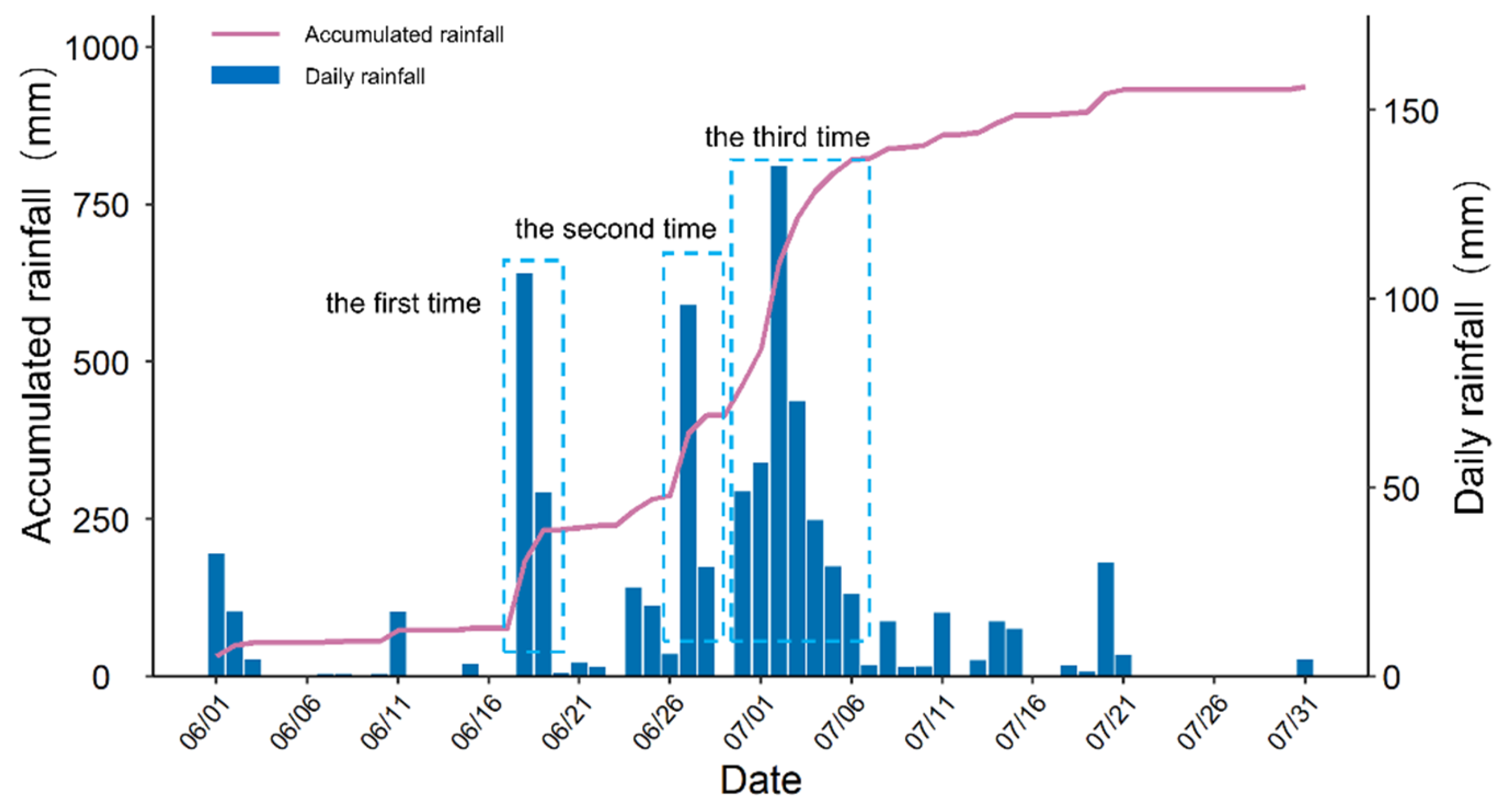
4.1. Rainfall Characteristics
4.2. Development Law of Landslide
4.2.1. Spatial Distribution
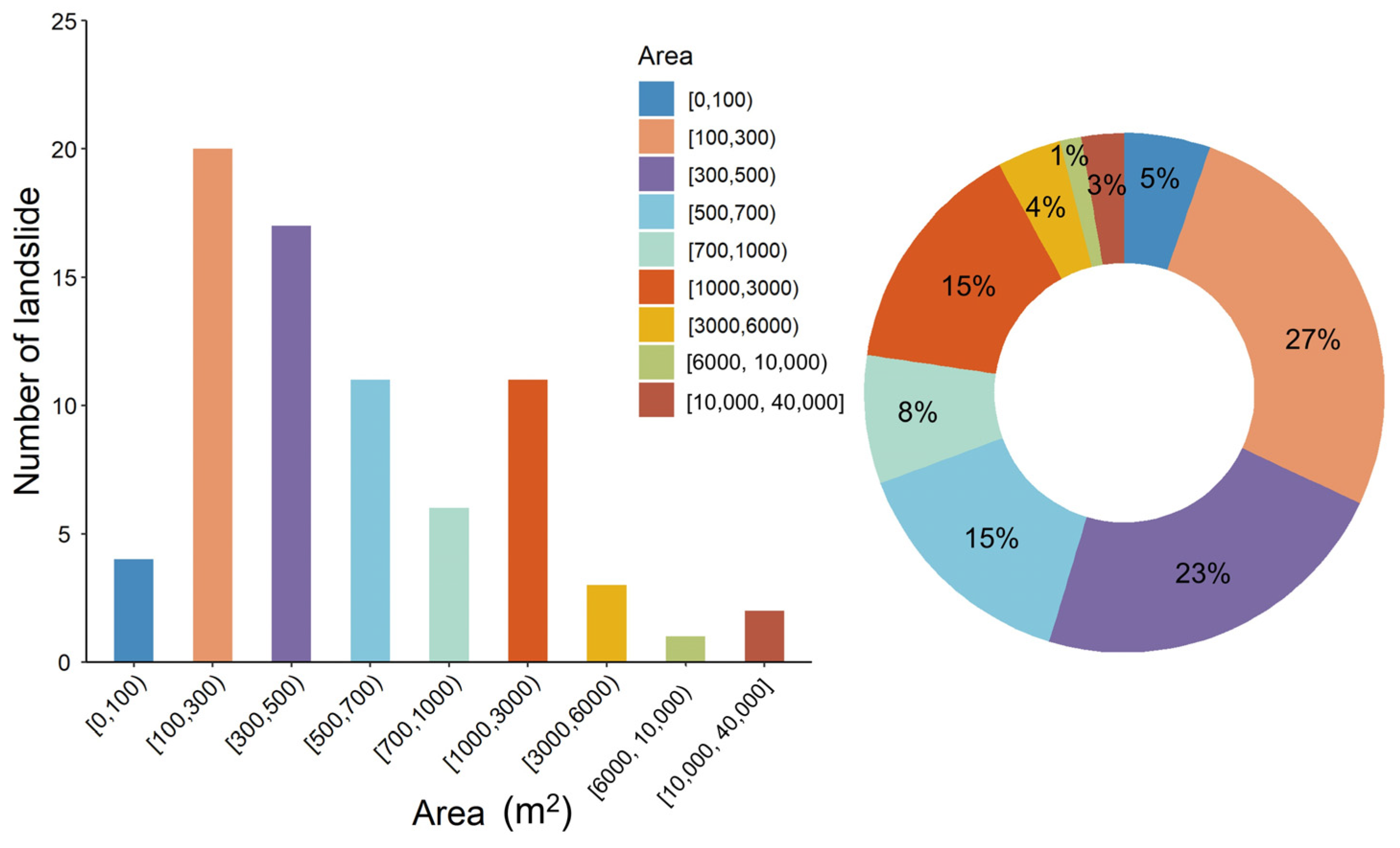
4.2.2. Landslide Scale
4.2.3. Landslide Thickness
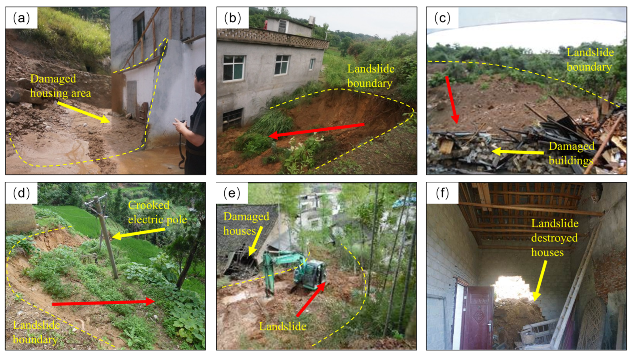
4.3. Disaster Severity
5. Results of Influencing Factor Analysis
5.1. Topography
5.1.1. Altitude
5.1.2. Slope
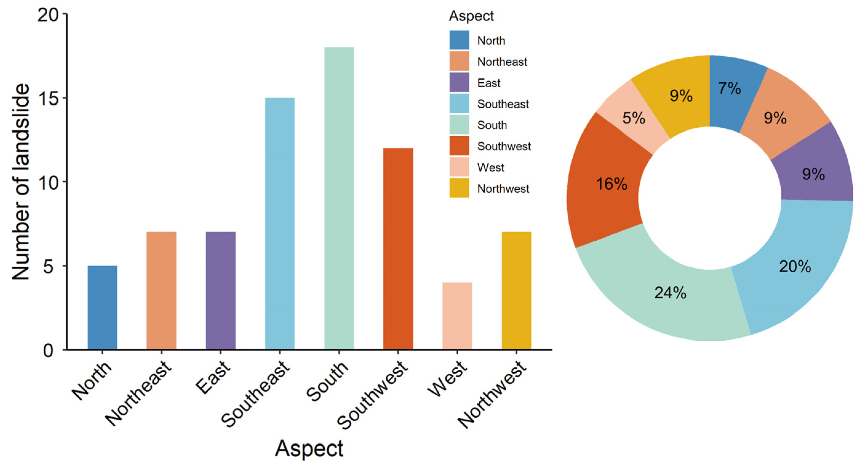
5.1.3. Slope Aspect
5.2. Formation Lithology
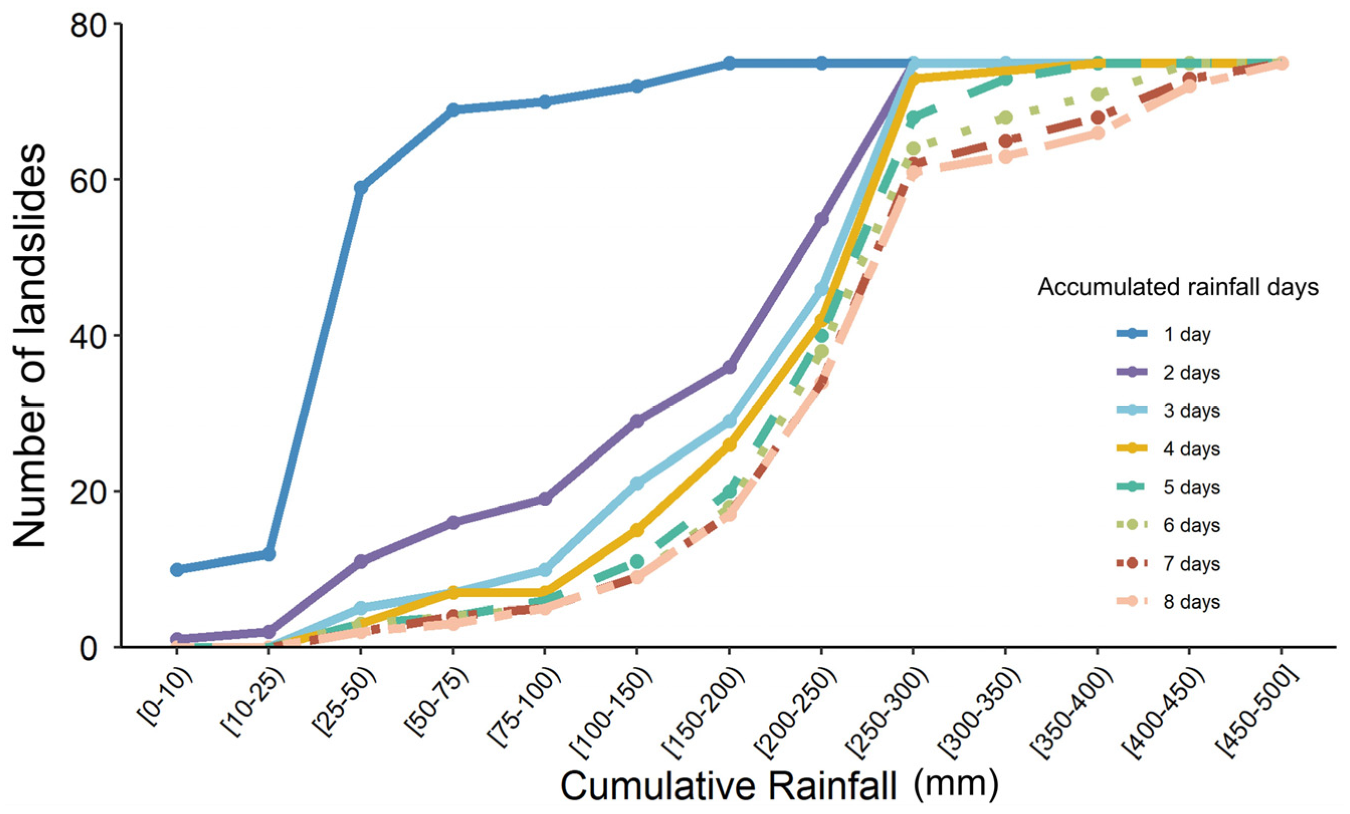
5.3. Rainfall
6. Results of Typical Rainfall-Induced Landslide Analysis
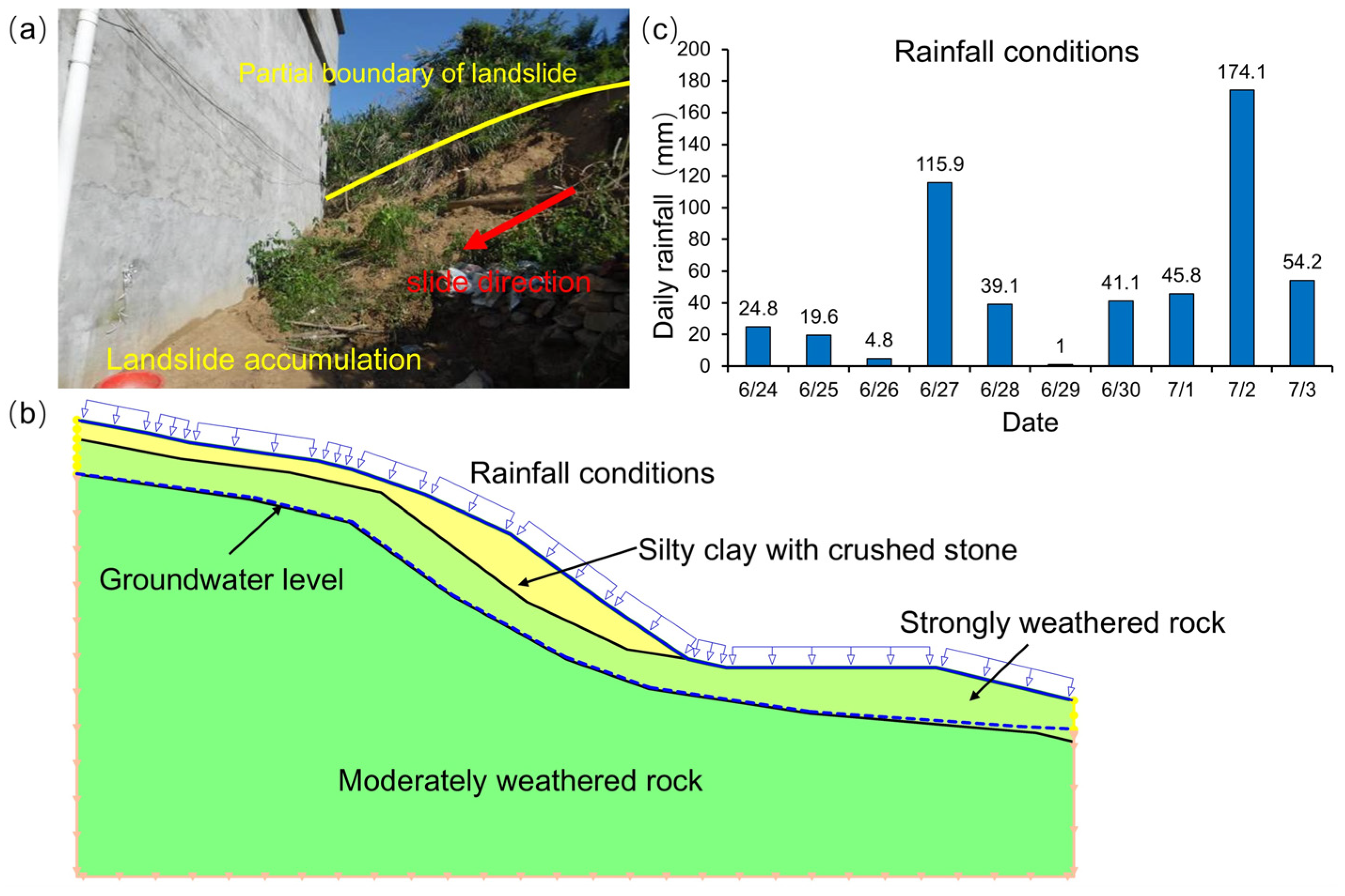
6.1. Landslide Characteristics
6.2. Model Building
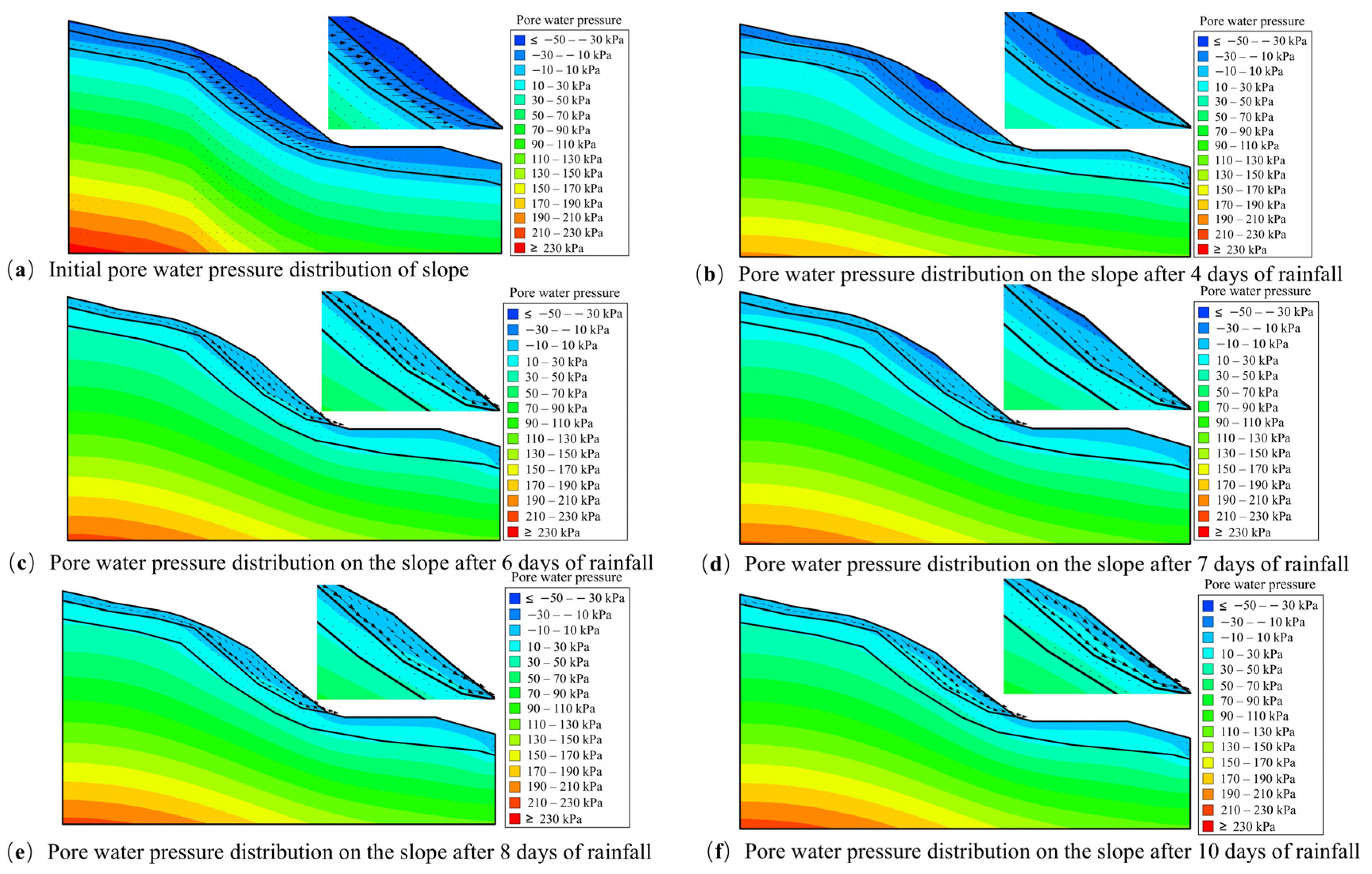
6.3. Pore Water Pressure
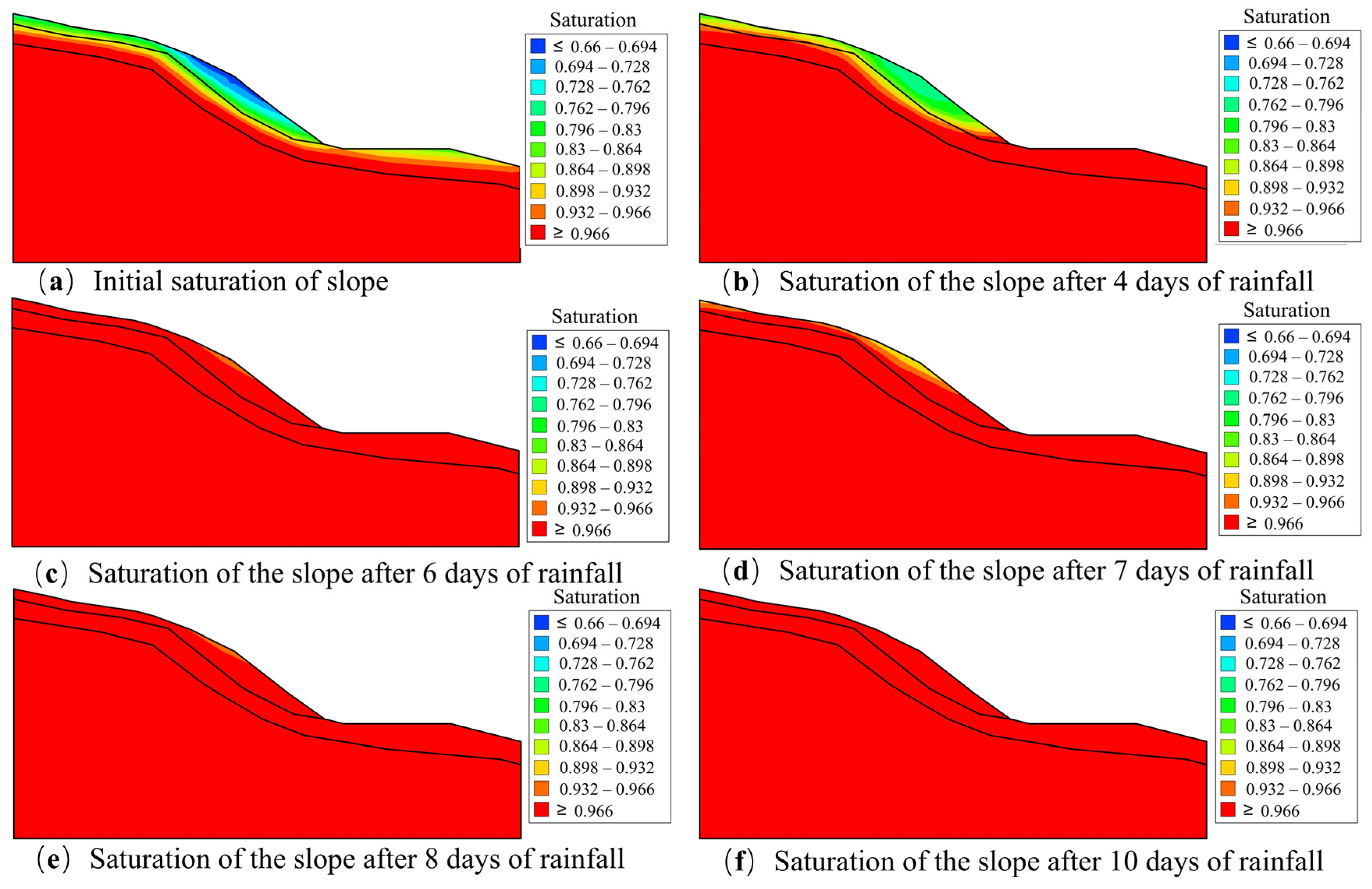
6.4. Saturation
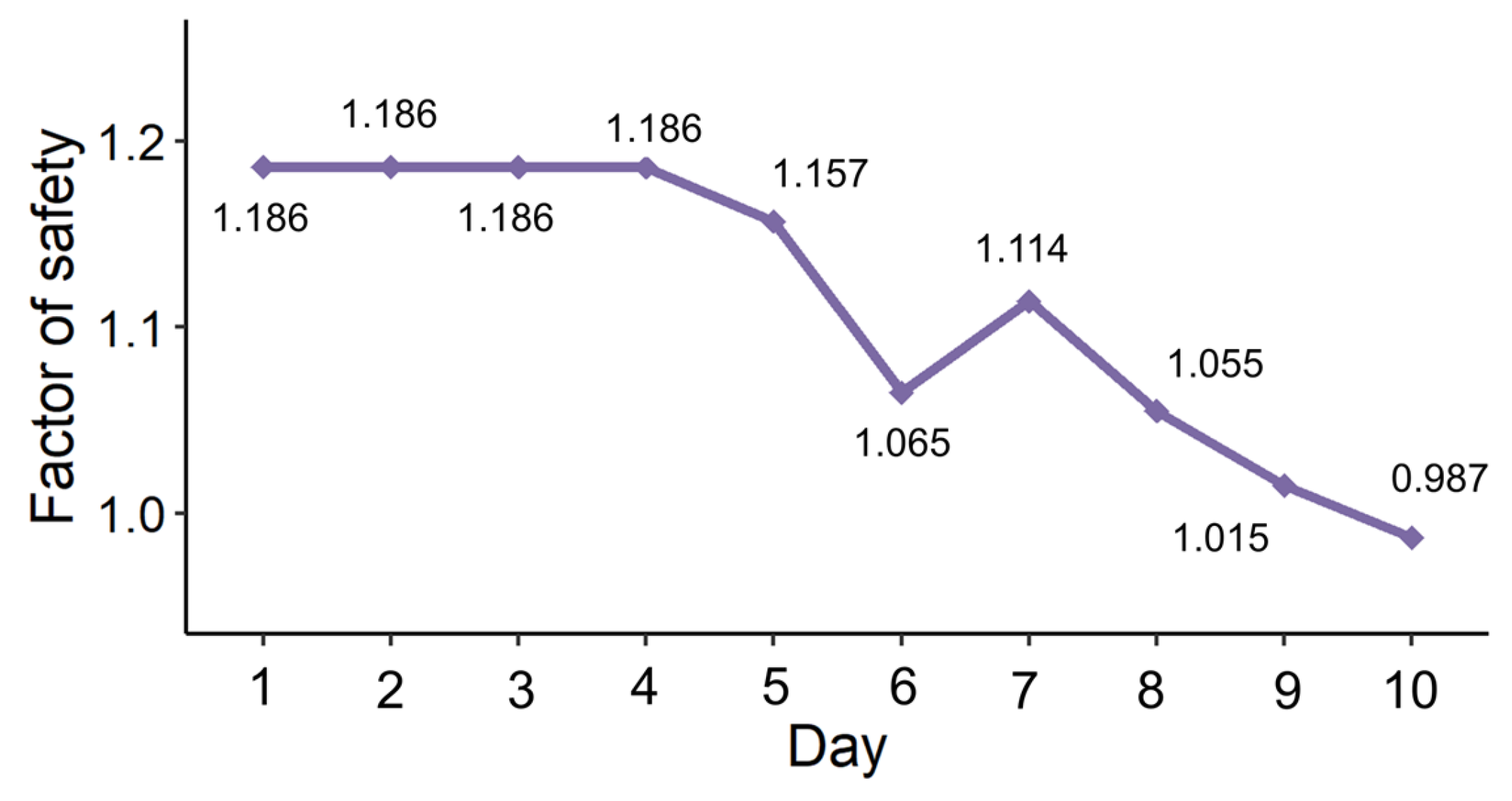
6.5. Stability
7. Discussion
7.1. Landslide Characteristics
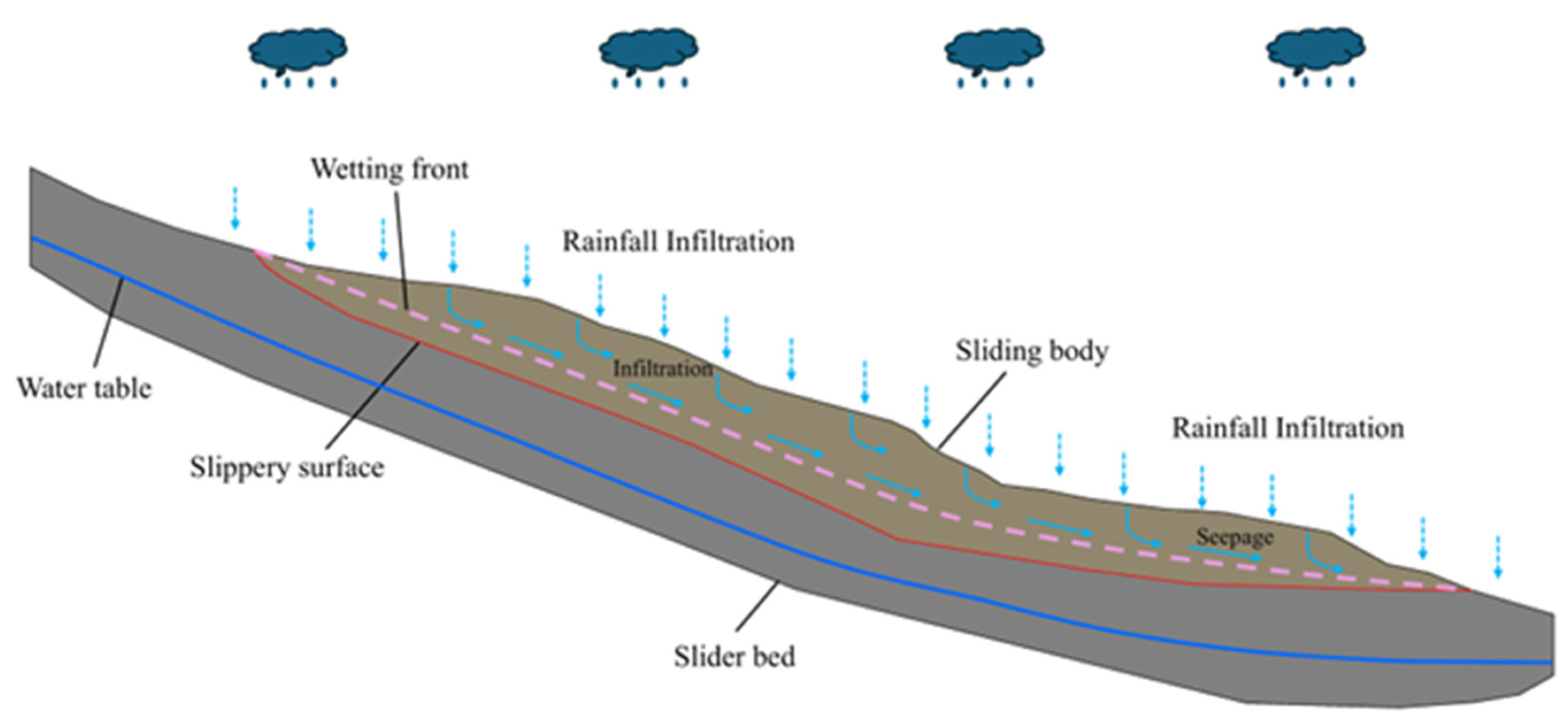
7.2. Failure Mechanism
8. Conclusions
- (1)
- The statistical analysis of landslides reveals that rainfall-induced landslides are predominantly small and shallow. The landslides are characterized by their high number, widespread distribution, and relatively concentrated distribution. The landslide incidence is higher in the north and east, and less frequent in the southwest. This variation is attributed to the distinct topographical features and human activity patterns within the study area.
- (2)
- Landslides have been observed to occur most frequently on slopes with low altitudes, slopes of 30–45°, and slope directions of SE, S, and SW. These terrain conditions are closely related to human engineering activities, such as the construction of residential structures, and transportation infrastructure. This correlation is a primary factor that contributes to the high number of casualties and substantial property losses observed in landslide-affected areas. The occurrence of landslides is predominantly observed in metamorphic rock regions, with a lower frequency in igneous rock areas.
- (3)
- Landslides are influenced by two distinct patterns of rainfall: the first is characterized by short-term extreme rainstorms, and the second is the combined effect of continuous accumulated rainfall and rainfall on the day that landslides occur. The threshold for rainfall on the day of most landslides is 20–50 mm, and the threshold for accumulated rainfall over multiple days is 250–300 mm. To enhance the efficacy of landslide prevention strategies, a focus on the day of rainfall and the accumulated rainfall over the previous three days is imperative.
- (4)
- The primary factors contributing to landslides can be categorized into two primary factors: the artificial modification of slope topography, which serves as the fundamental control, and the occurrence of extreme rainfall, which functions as the triggering effect. The slope failure mechanism is predominantly driven by dynamic water seepage.
Author Contributions
Funding
Data Availability Statement
Acknowledgments
Conflicts of Interest
References
- Das, S.; Sarkar, S.; Kanungo, D.P. Rainfall-induced landslide (RFIL) disaster in Dima Hasao, Assam, Northeast India. Landslides 2022, 19, 2801–2808. [Google Scholar] [CrossRef]
- Zou, Y.; Qi, S.; Guo, S.; Zheng, B.; Zhan, Z.; He, N.; Huang, X.; Hou, X.; Liu, H. Factors controlling the spatial distribution of coseismic landslides triggered by the Mw 6.1 Ludian earthquake in China. Eng. Geol. 2022, 296, 106477. [Google Scholar] [CrossRef]
- Zou, Z.; Tang, H.; Criss, R.E.; Hu, X.; Xiong, C.; Wu, Q.; Yuan, Y. A model for interpreting the deformation mechanism of reservoir landslides in the Three Gorges Reservoir area, China. Nat. Hazards Earth Syst. Sci. 2020, 21, 517–532. [Google Scholar] [CrossRef]
- Hu, S.; Qiu, H.; Wang, N.; Wang, X.; Ma, S.; Yang, D.; Wei, N.; Liu, Z.; Shen, Y.; Cao, M.; et al. Movement process, geomorphological changes, and influencing factors of a reactivated loess landslide on the right bank of the middle of the Yellow River, China. Landslides 2022, 19, 1265–1295. [Google Scholar] [CrossRef]
- Minder, J.R.; Roe, G.H.; Montgomery, D.R. Spatial patterns of rainfall and shallow landslide susceptibility. Water Resour. Res. 2009, 45, W04419. [Google Scholar] [CrossRef]
- Moreiras, S.M. Climatic effect of ENSO associated with landslide occurrence in the Central Andes, Mendoza Province, Argentina. Landslides 2005, 2, 53–59. [Google Scholar] [CrossRef]
- Zieher, T.; Gallotti, G.; Rianna, G.; Reder, A.; Pfeiffer, J. Exploring the effects of climate change on the water balance of a continuously moving deep-seated landslide. Nat. Hazards 2023, 115, 357–387. [Google Scholar] [CrossRef]
- He, J.; Qiu, H.; Qu, F.; Hu, S.; Yang, D.; Shen, Y.; Zhang, Y.; Sun, H.; Cao, M. Prediction of spatiotemporal stability and rainfall threshold of shallow landslides using the TRIGRS and Scoops3D models. Catena 2021, 197, 104999. [Google Scholar] [CrossRef]
- Zhou, C.; Huang, W.; Ai, D.; Xu, H.; Yuan, J.; Kou, L.; Luo, X. Catastrophic landslide triggered by extreme rainfall in Chongqing, China: July 13, 2020, Niuerwan landslide. Landslides 2022, 19, 2397–2407. [Google Scholar] [CrossRef]
- Xue, D.; Dai, C.; Wu, Y.; Chen, K.; Tang, J.; Zhang, S. A catastrophic rainfall-induced high landslide, occurred on December 4, 2020, in the Qingliucun mountainous area of Southwest China. Landslides 2023, 20, 2187–2197. [Google Scholar] [CrossRef]
- Jug, J.; Grabar, K.; Bek, A.; Strelec, S. Stabilization of Shallow Landslides Induced by Rainwater Infiltration—A Case Study from Northern Croatia. Geotechnics 2024, 4, 242–263. [Google Scholar] [CrossRef]
- Tan, Y.L.; Cao, J.J.; Xiang, W.X.; Xu, W.Z.; Tian, J.W.; Gou, Y. Slope stability analysis of saturated–unsaturated based on the GEO-studio: A case study of Xinchang slope in Lanping County, Yunnan Province, China. Environ. Earth Sci. 2023, 82, 322. [Google Scholar] [CrossRef]
- Yu, L.; Yan, C.; Guo, S.; Li, H.; Tan, J.Z.; Liu, G.; Xu, C.H.; Liu, Y. Mechanism analysis of Zulongding landslide on gentle piedmont slope: A creeping landslide triggered by rainfall. Nat. Hazards 2023, 118, 1211–1234. [Google Scholar] [CrossRef]
- Wang, H.; Jiang, Z.; Xu, W.; Wang, R.; Xie, W. Physical model test on deformation and failure mechanism of deposit landslide under gradient rainfall. Bull. Eng. Geol. Environ. 2022, 81, 66. [Google Scholar] [CrossRef]
- Sengani, F.; Mulenga, F. Influence of rainfall intensity on the stability of unsaturated soil slope: Case Study of R523 road in Thulamela Municipality, Limpopo Province, South Africa. Appl. Sci. 2020, 10, 8824. [Google Scholar] [CrossRef]
- Yu, S.; Ren, X.; Zhang, J. Using an improved SPH algorithm to simulate thermo-hydro-mechanical-damage coupling problems in rock masses. Case Stud. Therm. Eng. 2023, 47, 103085. [Google Scholar] [CrossRef]
- Yu, S.; Zhou, Y.; Yang, J.; Chen, W. Hydraulic fracturing modelling of glutenite formations using an improved form of SPH method. Geoenergy Sci. Eng. 2023, 277, 211842. [Google Scholar] [CrossRef]
- Wang, S.; Demisa, M.G.; Han, B.; Hou, Q.; Zhang, Z. A material point method analysis of failure mechanism and kinematic behavior of rainfall-induced landslide. Nat. Hazards 2024, 120, 13875–13897. [Google Scholar] [CrossRef]
- Zhong, W.; Zhu, Y.; He, N. Physical model study of an intermittent rainfall-induced gently dipping accumulation landslide. Water 2022, 14, 1770. [Google Scholar] [CrossRef]
- Zhou, Z.; Shen, J.; Tang, S.; Duan, W.F.; Wang, J.Y.; Yang, R.C.; Zheng, S.Z.; Guo, F.L. Analysis of weakening law and stability of sliding zone soil in thrust-load-induced accumulation landslides triggered by rainfall infiltration. Water 2021, 13, 466. [Google Scholar] [CrossRef]
- Yu, X.; Zhao, T.; Gong, B.; Tang, C.A. The water weakening effect on the progressive slope failure under excavation and rainfall conditions. Bull. Eng. Geol. Environ. 2024, 83, 316. [Google Scholar] [CrossRef]
- Sun, L.; Li, C.; Shen, F. Two-surface progressive failure mechanism and stability quantitative evaluation of water-induced weakening retrogressive landslides: Case study for clay landslides, China. Bull. Eng. Geol. Environ. 2022, 81, 382. [Google Scholar] [CrossRef]
- Chen, H.-E.; Chiu, Y.-Y.; Tsai, T.-L.; Yang, J.-C. Effect of Rainfall, Runoff and Infiltration Processes on the Stability of Footslopes. Water 2020, 12, 1229. [Google Scholar] [CrossRef]
- Zhen, J.; Yang, X.; Wang, B.; Fan, H.; Meng, M. Study on the destruction of backfilled loess slopes by short-term extreme rainfall erosion. Bull. Eng. Geol. Environ. 2023, 82, 406. [Google Scholar] [CrossRef]
- Wang, T.; Liu, F.; Yu, Y.; Cai, H. Numerical analysis of hydrological response in loess excavation and filling area under multi-year precipitation infiltration. Bull. Eng. Geol. Environ. 2023, 82, 372. [Google Scholar] [CrossRef]
- Paronuzzi, P.; Bolla, A. Rainfall infiltration and slope stability of alpine colluvial terraces subject to storms (NE Italy). Eng. Geol. 2023, 323, 107199. [Google Scholar] [CrossRef]
- Guo, Z.; Huang, Q.; Liu, Y.; Wang, Q.; Chen, Y. Model experimental study on the failure mechanisms of a loess-bedrock fill slope induced by rainfall. Eng. Geol. 2023, 313, 106979. [Google Scholar] [CrossRef]
- Zhang, Z.; Sheng, Q.; Song, D.; Fu, X.; Zhou, Y.; Huang, J. Stability evaluation of the high fill deposit slope subjected to rainfall considering water deterioration. Bull. Eng. Geol. Environ. 2023, 82, 68. [Google Scholar] [CrossRef]
- Wei, S.-W.; Lv, S.; Jiang, J.-J.; Cai, D.-G.; Cui, Z.-D. Similarity Model Test on Rainfall Scouring Mechanism of High-Speed Railway Subgrade Slope. Appl. Sci. 2024, 14, 244. [Google Scholar] [CrossRef]
- Xiang, Z.; Yu, S.; Wang, X. Modeling the Hydraulic Fracturing Processes in Shale Formations Using a Meshless Method. Water 2024, 16, 1855. [Google Scholar] [CrossRef]
- Jayakody, S.H.S.; Uzuoka, R.; Ueda, K.; Xu, J. Unsaturated slopes behavior under antecedent intermittent rainfall patterns: Centrifuge and numerical study. Acta Geotech. 2023, 18, 5773–5790. [Google Scholar] [CrossRef]
- Duan, X.; Hou, T.; Jiang, X. Study on stability of exit slope of Chenjiapo tunnel under extreme rainstorm conditions. Nat. Hazards 2021, 107, 1387–1411. [Google Scholar] [CrossRef]
- Guo, Y.; Du, Y.; Shan, W.; Liu, M.; Zhang, C. Numerical Analysis on the Stability of Sandstone-Covered Mudstone Cutting Slopes Considering Rainfall Infiltration. Appl. Sci. 2023, 13, 1802. [Google Scholar] [CrossRef]
- Sun, Y.; Yang, K.; Hu, R.; Wang, G.; Lv, J. Model test and numerical simulation of slope instability process induced by rainfall. Water 2022, 14, 3997. [Google Scholar] [CrossRef]
- Chinkulkijniwat, A.; Tirametatiparat, T.; Supotayan, C.; Yubonchit, S.; Horpibulsuk, S.; Salee, R.; Voottipruex, P. Stability characteristics of shallow landslide triggered by rainfall. J. Mt. Sci. 2019, 16, 2171–2183. [Google Scholar] [CrossRef]
- Schilirò, L.; Marmoni, G.M.; Fiorucci, M.; Pecci, M.; Mugnozza, G.S. Preliminary insights from hydrological field monitoring for the evaluation of landslide triggering conditions over large areas. Nat. Hazards 2023, 118, 1401–1426. [Google Scholar] [CrossRef]
- Bodman, G.B.; Colman, E.A. Moisture and Energy Conditions during Downward Entry of Water Into Soils. Soil Sci. Soc. Am. J. 1944, 8, 116–122. [Google Scholar] [CrossRef]
- van Genuchten, M.T. A Closed-form equation for predicting the hydraulic conductivity of unsaturated Soils. Soil Sci. Soc. Am. J. 1980, 44, 892–898. [Google Scholar] [CrossRef]
- Zolfaghari, A.R.; Heath, A.C.; Mccombie, P.F. Simple genetic algorithm search for critical non-circular failure surface in slope stability analysis. Comput. Geotech. 2005, 32, 139–152. [Google Scholar] [CrossRef]
- Nakileza, B.R.; Nedala, S. Topographic influence on landslides characteristics and implication for risk management in upper Manafwa catchment, Mt Elgon Uganda. Geoenviron. Disasters 2020, 7, 27. [Google Scholar] [CrossRef]
- Capitani, M.; Ribolini, A.; Bini, M. The slope aspect: A predisposing factor for landsliding? Comptes Rendus Geosci. 2013, 345, 427–438. [Google Scholar] [CrossRef]
- Dai, F.C.; Lee, C.F. Landslide characteristics and slope instability modeling using GIS, Lantau Island, Hong Kong. Geomorphology 2002, 42, 213–228. [Google Scholar] [CrossRef]
- Vasu, N.N.; Lee, S.R.; Pradhan, A.M.S.; Kim, Y.T.; Kang, S.H.; Lee, D.H. A new approach to temporal modelling for landslide hazard assessment using an extreme rainfall induced-landslide index. Eng. Geol. 2016, 215, 36–49. [Google Scholar] [CrossRef]
- Ma, S.; Shao, X.; Xu, C. Landslides Triggered by the 2016 Heavy Rainfall Event in Sanming, Fujian Province: Distribution Pattern Analysis and Spatio-Temporal Susceptibility Assessment. Remote Sens. 2023, 15, 2738. [Google Scholar] [CrossRef]
- Licata, M.; Buleo Tebar, V.; Seitone, F.; Fubelli, G. The Open Landslide Project (OLP), a New Inventory of Shallow Landslides for Susceptibility Models: The Autumn 2019 Extreme Rainfall Event in the Langhe-Monferrato Region (Northwestern Italy). Geosciences 2023, 13, 289. [Google Scholar] [CrossRef]
- Wu, T.; Xie, X.; Wu, H.; Zeng, H.; Zhu, X. A Quantitative Analysis Method of Regional Rainfall-Induced Landslide Deformation Response Variation Based on a Time-Domain Correlation Model. Land 2022, 11, 703. [Google Scholar] [CrossRef]
- Froude, M.J.; Petley, D.N. Global fatal landslide occurrence from 2004 to 2016. Nat. Hazards Earth Syst. Sci. 2018, 18, 2161–2181. [Google Scholar] [CrossRef]
- Chen, P.; Mirus, B.; Lu, N.; Godt, J.W. Effect of hydraulic hysteresis on stability of infinite slopes under steady infiltration. J. Geotech. Geoenviron. Eng. 2017, 143, 04017041. [Google Scholar] [CrossRef]
- Tan, H.; He, Z.; Yu, H.; Yang, S.; Wang, M.; Gu, X.; Xu, M. Characterization of extreme rainfall changes and response to temperature changes in Guizhou Province, China. Sci. Rep. 2024, 14, 20495. [Google Scholar] [CrossRef]
- Yan, C.; Gong, D. Assessing framework of rainfall-induced landslide hazard considering spatiotemporal asymmetry in extreme precipitation indices under climate change. Theor. Appl. Climatol. 2024, 155, 7961–7975. [Google Scholar] [CrossRef]


| Stratigraphic Age | Lithology Description |
|---|---|
| Archean–Proterozoic–Proterozoic Sinian System (Ar-Pt-Z1) | Metamorphic rocks mainly include gneiss, schist, diabase, migmatite, etc. Igneous rocks are mainly gabbro and diabase. |
| Proterozoic Sinian System and Paleozoic Cambrian System (Z2-∈) | Sedimentary rocks mainly include dolomite, limestone, and shale. Igneous rocks are mainly diorite, gabbro, and diabase. |
| Paleozoic Silurian (S) | Mainly mudstone, silty mudstone, and fine-grained sandstone. |
| Paleozoic Permian (P) | The sedimentary rocks are mainly limestone, siliceous rock, siliceous limestone, and flint limestone. Igneous rocks are mainly monzogranite, diorite, and quartz diorite. |
| Mesozoic Triassic, Jurassic, and Cretaceous (T-J-K) | Sedimentary rocks are mainly composed of purple siltstone, argillaceous siltstone, quartz sandstone, mudstone, fine sandstone, and conglomerate, interbedded with mudstone or shale. Igneous rocks are mainly biotite granite. |
| Cenozoic Quaternary (Q) | Mainly alluvial, residual slope accumulation, and landslide accumulation. Mainly sand, silty clay, gravel-containing sand, sandy gravel. |
| Landslide Conditioning Factor | Category | Number of Landslides | Landslide Conditioning Factor | Category | Number of Landslides |
|---|---|---|---|---|---|
| Area (m2) | [0, 100) | 4 | Volume (m3) | [0, 100) | 4 |
| [100, 300) | 20 | [100, 250) | 12 | ||
| [300, 500) | 17 | [250, 500) | 13 | ||
| [500, 700) | 11 | [500, 1000) | 11 | ||
| [700, 1000) | 6 | [1000, 1500) | 7 | ||
| [1000, 3000) | 11 | [1500, 3000) | 6 | ||
| [3000, 6000) | 3 | [3000, 6000) | 8 | ||
| [6000, 10,000) | 1 | [6000, 10,000) | 5 | ||
| [10,000, 40,000] | 2 | [10,000, 30,000) | 3 | ||
| Slope (°) | [20, 25) | 1 | [30,000, 100,000) | 3 | |
| [25, 30) | 5 | [100,000, 1,000,000] | 3 | ||
| [30, 35) | 19 | Thickness (m) | [0, 1) | 5 | |
| [35, 40) | 9 | [1, 2) | 16 | ||
| [40, 45) | 16 | [2, 3) | 25 | ||
| [45, 50) | 8 | [3, 4) | 9 | ||
| [50, 55) | 5 | [4, 5) | 3 | ||
| [55, 60) | 2 | [5, 6) | 7 | ||
| [60, 65) | 7 | [6, 7) | 0 | ||
| [65, 70] | 3 | [7, 8) | 1 | ||
| Aspect | N | 5 | [8, 9) | 3 | |
| NE | 7 | [9, 10) | 1 | ||
| E | 7 | [10, 11) | 3 | ||
| SE | 15 | [11, 30] | 2 | ||
| S | 18 | Altitude (m) | [0, 100) | 15 | |
| SW | 12 | [100, 200) | 48 | ||
| W | 4 | [200, 300) | 7 | ||
| NW | 7 | [300, 400) | 3 | ||
| Stratigraphic age and lithology | Gneiss (Ar-Pt) | 62 | [400, 500) | 1 | |
| Granite (ηγ5) | 13 | [500, 600) | 1 |
| Level Classification | 24 h Cumulative Rainfall (mm) | Cumulative Days |
|---|---|---|
| no rain or scattered light rain | <0.1 | 18 |
| light rain | 0.1~9.9 | 22 |
| moderate rain | 10~24.9 | 9 |
| heavy rain | 25.0~49.9 | 7 |
| torrential rain | 50.0~99.9 | 3 |
| extreme torrential rain | 100.0~249.9 | 2 |
| Rock and Soil Layer | Density (kg/m3) | Cohesion (c/Kpa) | Internal Friction Angle (Φ/°) | Saturated Permeability Coefficient (m/d) | Maximum Degree of Water Saturation |
|---|---|---|---|---|---|
| Silty clay with gravel | 2100 | 13 | 15 | 0.530000 | 0.35 |
| Strongly weathered rock | 2230 | 22.4 | 22 | 0.047347 | 0.25 |
| Medium weathered rock | 2560 | 25.6 | 35.2 | 0.002592 | 0.22 |
Disclaimer/Publisher’s Note: The statements, opinions and data contained in all publications are solely those of the individual author(s) and contributor(s) and not of MDPI and/or the editor(s). MDPI and/or the editor(s) disclaim responsibility for any injury to people or property resulting from any ideas, methods, instructions or products referred to in the content. |
© 2025 by the authors. Licensee MDPI, Basel, Switzerland. This article is an open access article distributed under the terms and conditions of the Creative Commons Attribution (CC BY) license (https://creativecommons.org/licenses/by/4.0/).
Share and Cite
Li, Y.; Yan, E.; Xiao, W. Study on Shallow Landslide Induced by Extreme Rainfall: A Case Study of Qichun County, Hubei, China. Water 2025, 17, 530. https://doi.org/10.3390/w17040530
Li Y, Yan E, Xiao W. Study on Shallow Landslide Induced by Extreme Rainfall: A Case Study of Qichun County, Hubei, China. Water. 2025; 17(4):530. https://doi.org/10.3390/w17040530
Chicago/Turabian StyleLi, Yousheng, Echuan Yan, and Weibo Xiao. 2025. "Study on Shallow Landslide Induced by Extreme Rainfall: A Case Study of Qichun County, Hubei, China" Water 17, no. 4: 530. https://doi.org/10.3390/w17040530
APA StyleLi, Y., Yan, E., & Xiao, W. (2025). Study on Shallow Landslide Induced by Extreme Rainfall: A Case Study of Qichun County, Hubei, China. Water, 17(4), 530. https://doi.org/10.3390/w17040530