Integrated Geomorphic Mapping and Hydraulic Modeling to Identify Potential Channel Reconnection Sites for Alternatives Analysis on the Clearwater River, Washington, USA
Abstract
1. Introduction
2. Study Area
3. Methods
3.1. Geomorphic and Landslide Mapping
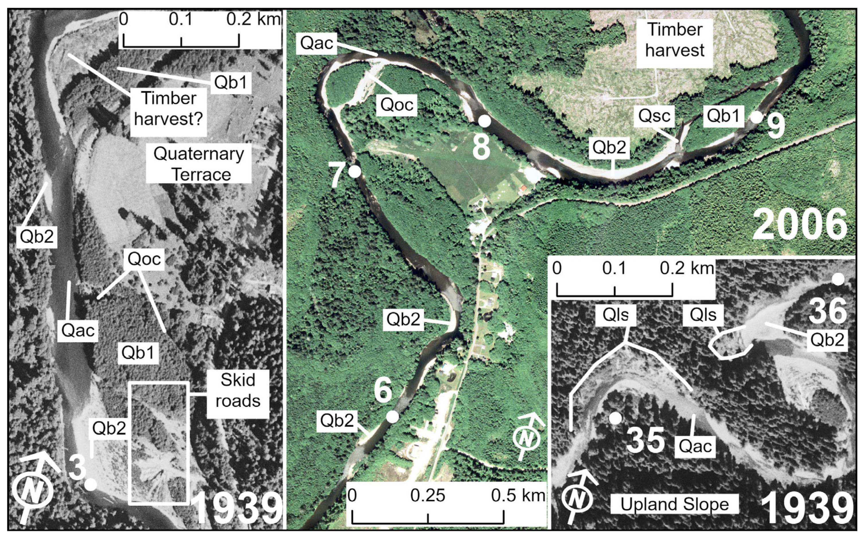
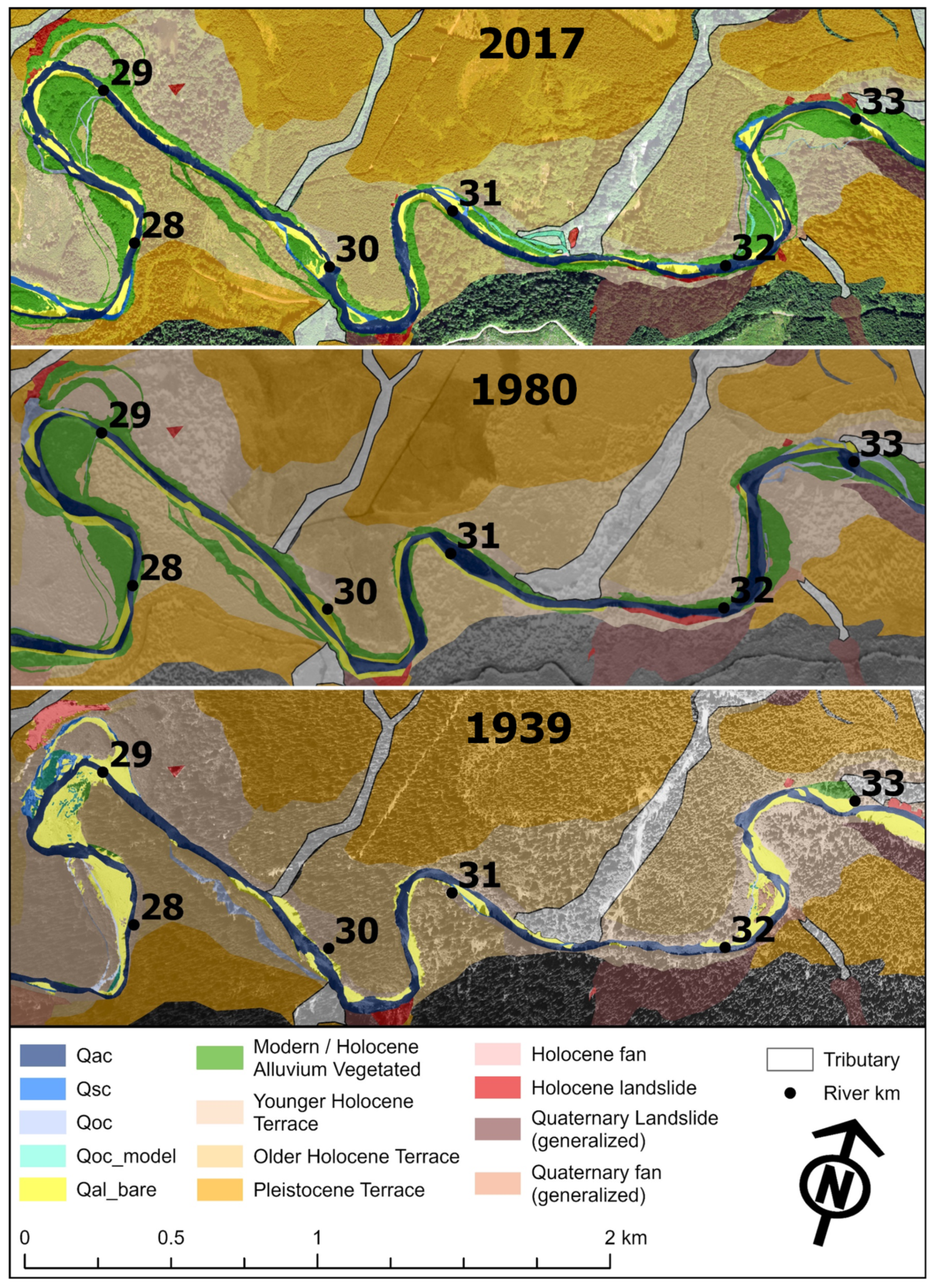
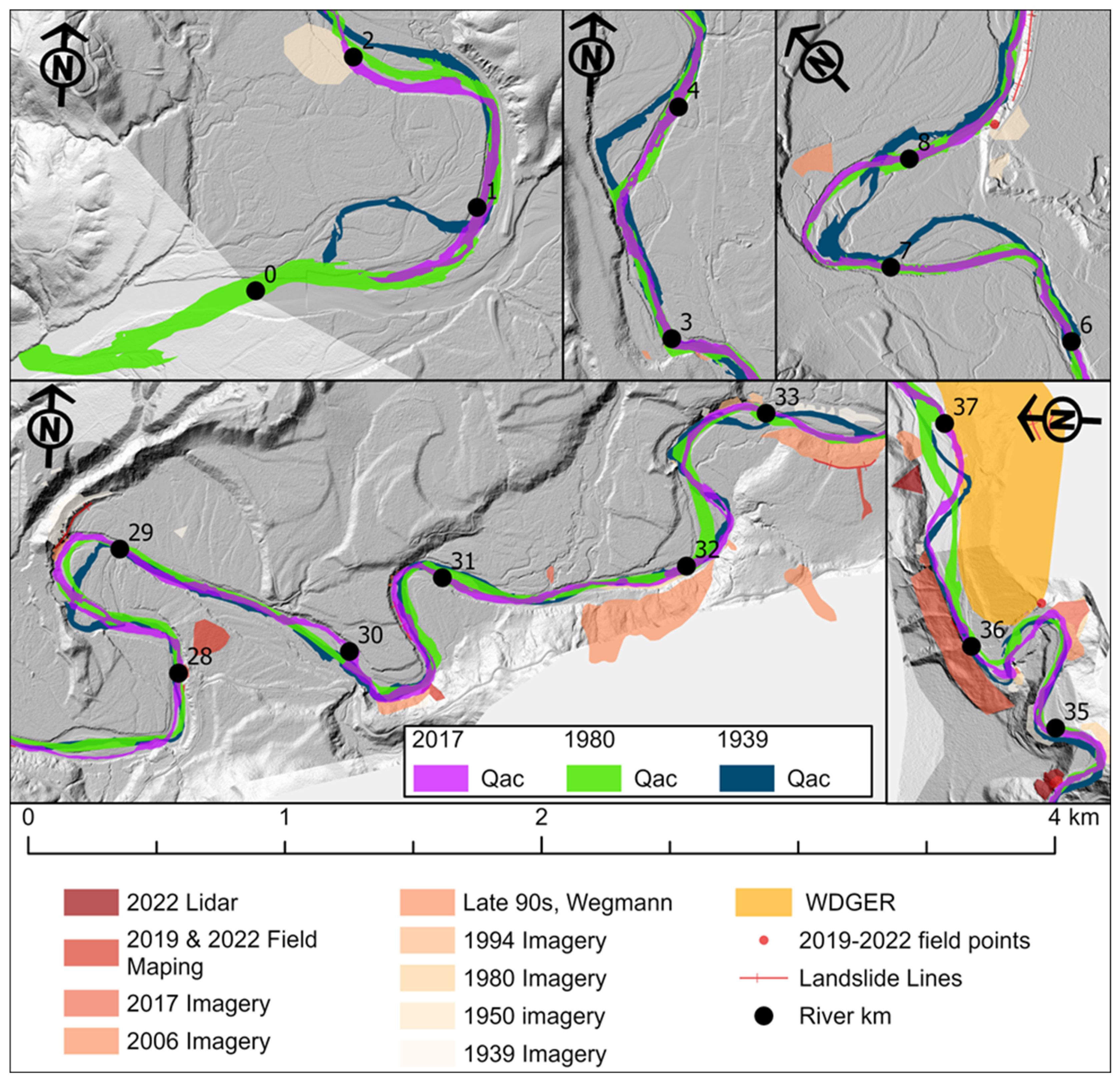
- The mainstem channel (Qac) within the wetted perimeter or the defined channel banks of the Clearwater River. Occasionally, the mainstem channel may split around small mid-channel bars.
- Side channels (Qsc) exhibit a defined bed and banks with water apparent in the channel or large swaths of bare alluvium, indicating the channel receives frequent flow.
- Overflow channels (Qoc) exhibit a defined bed and banks that only receive flow during larger flood events. Because portions of the Clearwater River are heavily treed, these channels often appear as a dark lineation through the forest cover, and we mapped many with low confidence. These channels may originate from another channel or originate at the transition between unvegetated alluvium and defined channel banks. For mapping year 2017, we confirmed that all overflow channels mapped from satellite imagery were wetted by the 10 yr recurrence interval peak discharge.
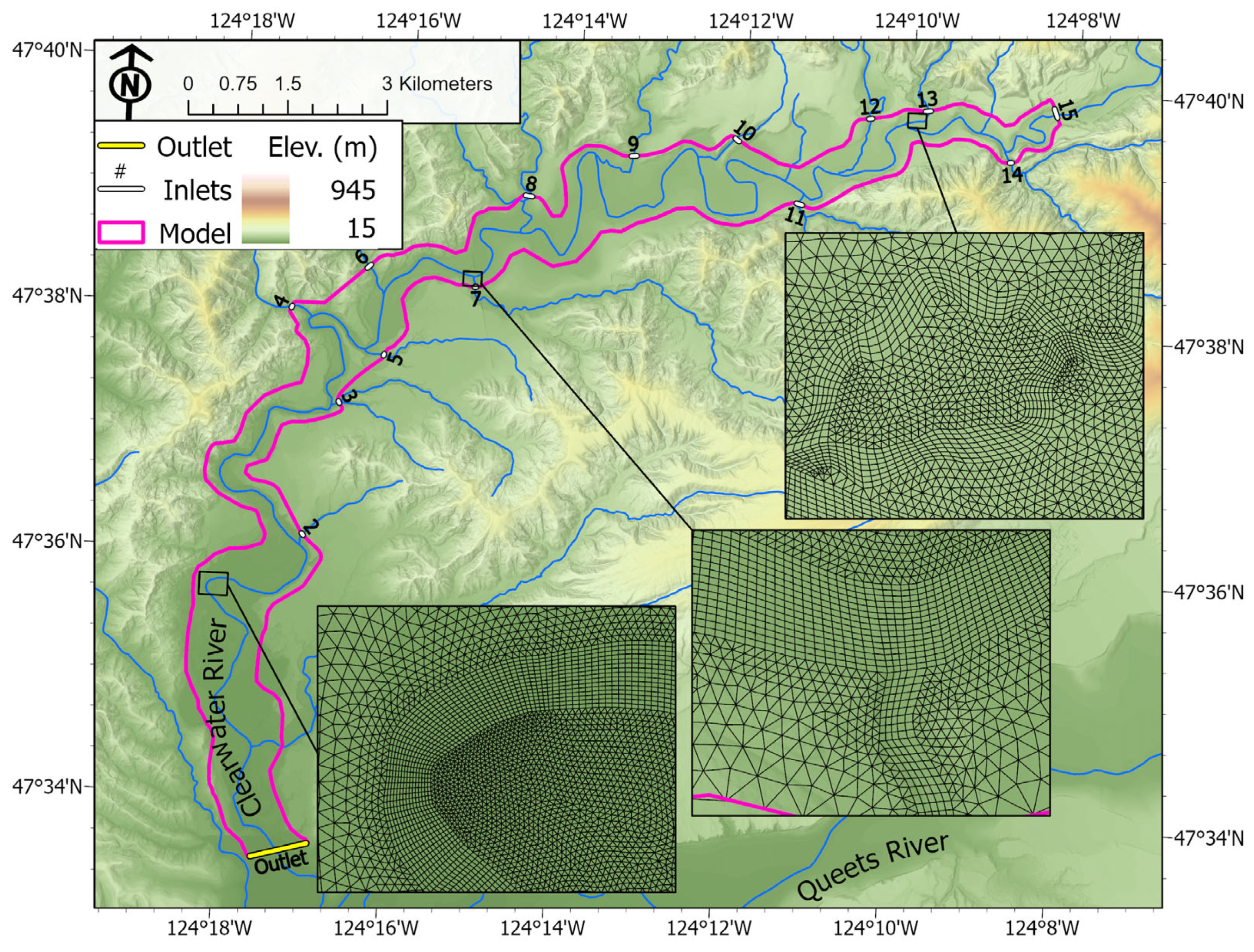
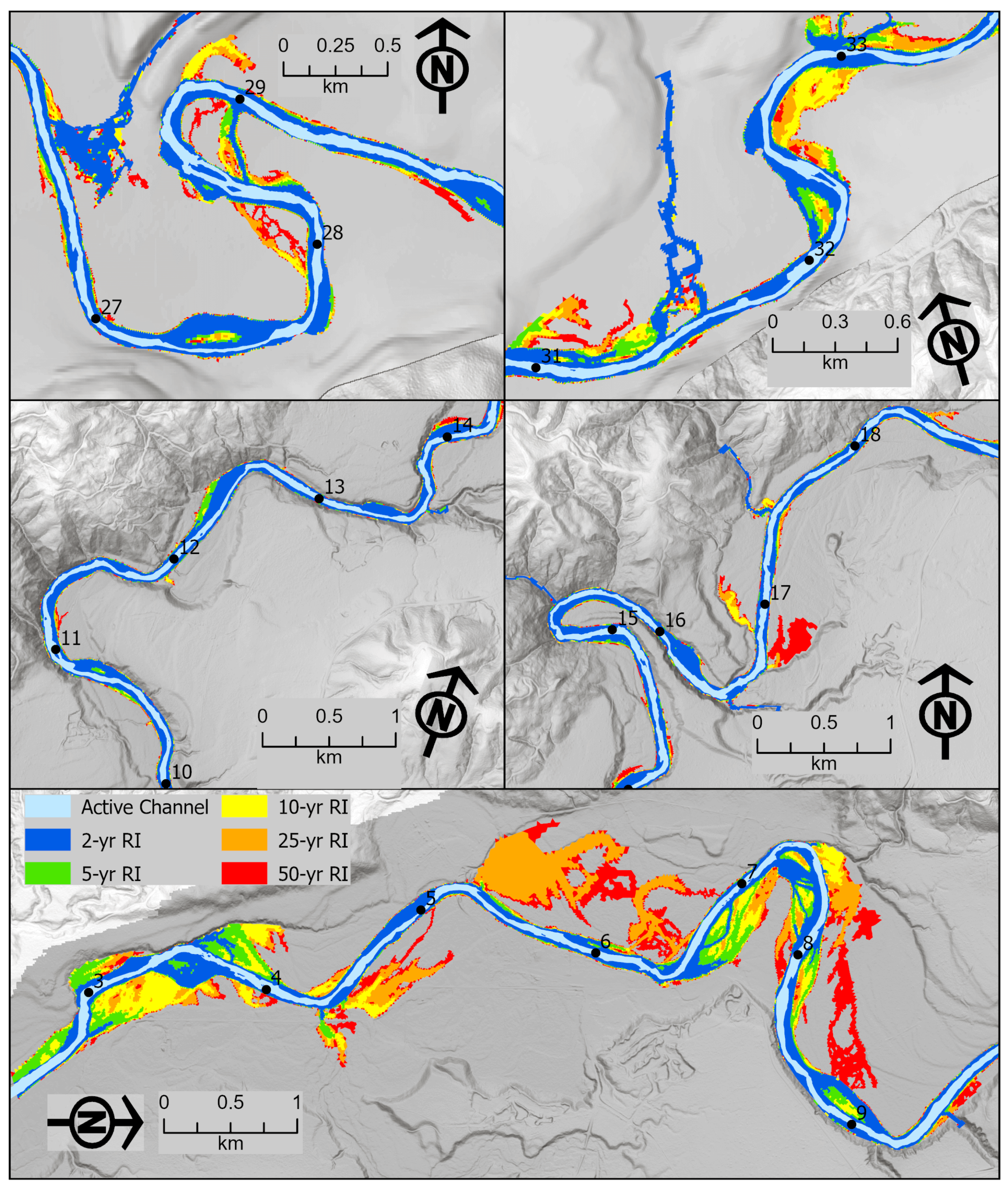
- Modeled overflow channels (Qocmodel) demonstrate defined flow paths, distinct from widespread floodplain inundation, in the hydraulic model for 2 yr, 5 yr, and 10 yr recurrence interval peak discharges. We identified these channels via hydraulic modeling using modern topography and not via imagery mapping.
- Unvegetated (bare) alluvium (Qalbare) is modern/Holocene alluvium dominated by bare sand or gravel, or only small shrubs and grasses, indicating frequent inundation. This includes lateral bars, point bars, mid-channel bars, and exposed alluvium adjacent to channels. Within the GIS mapping, these bars are identified as ‘Qb2’ to indicate a younger bar than ‘Qb1’ (defined below), but we use the term Qalbare here for clarity.
- Vegetated alluvium (Qalveg) is defined as modern/Holocene alluvium, vegetated by dense shrubs or trees. This is low-lying alluvium located below the younger Holocene terraces mapped by Wegmann (Qt6 and Qt7) [31]. We started with Wegmann’s Quaternary mapping, and it was difficult to differentiate terraces from low-lying, vegetated alluvium on historical imagery. Thus, Qalveg becomes more expansive in later photosets, as the channel laterally migrates, and we can conclude that vegetated areas have recently interacted with the river channel. Within the Qalveg unit, we also specifically map subunits within the ESRI ArcPro shapefile attributes.
- Vegetated bars (Qb1), which are surrounded by defined channels (mainstem channel, side channels, or overflow channels) or unvegetated alluvium was mapped. Because these bars are surrounded by channels or bare alluvium, they are more likely to interact with the river channel and are included as part of the active geomorphic corridor.
- Disconnected alluvium is defined as vegetated alluvium, outside of the active geomorphic corridor, that was previously occupied by channels or was bare alluvium in 1939–2006 imagery. The GIS mapping files provide additional details about when this unit was last occupied by active channels or bare alluvium. We distinguish these units as they could be potential targets for restoration efforts to reconnect former floodplains and channels.
- Alluvial or colluvial fans (Qfan) are defined by a triangular wedge of material, typically located at tributary junctions (alluvial fans) or in an area of landslide deposition (colluvial fan), including both modern fans we mapped, and separate, generalized Quaternary fans units mapped by Wegmann [31].
- Landslides (Qls) are areas of modern/Holocene mass-wasting, including generalized Quaternary landslides mapped by others [10,13]. We identified landslides during field work, or as bare scars on photosets, or hummocky topography and arcuate voids on hillshade imagery. We only concentrated on mapping landslides along the mainstem Clearwater River to identify areas of pervasive landsliding that could be problematic for any future in-channel designs.
- The active geomorphic corridor is defined as the spatial extent of active channels or bare alluvium, including vegetated bars which are surrounded by active channels and bare alluvium. The active geomorphic corridor includes units Qac, Qsc, Qoc, Qocmodel, Qalbare (Qb2), Qb1, and Qfan (i.e., [26]).
3.2. Hydraulic Modeling
Source Data
| Location of Interest | Inflow Point | Median Peak Discharge, Q (m3/s) | ||||
|---|---|---|---|---|---|---|
| 2-yr | 5-yr | 10-yr | 25-yr | 50-yr | ||
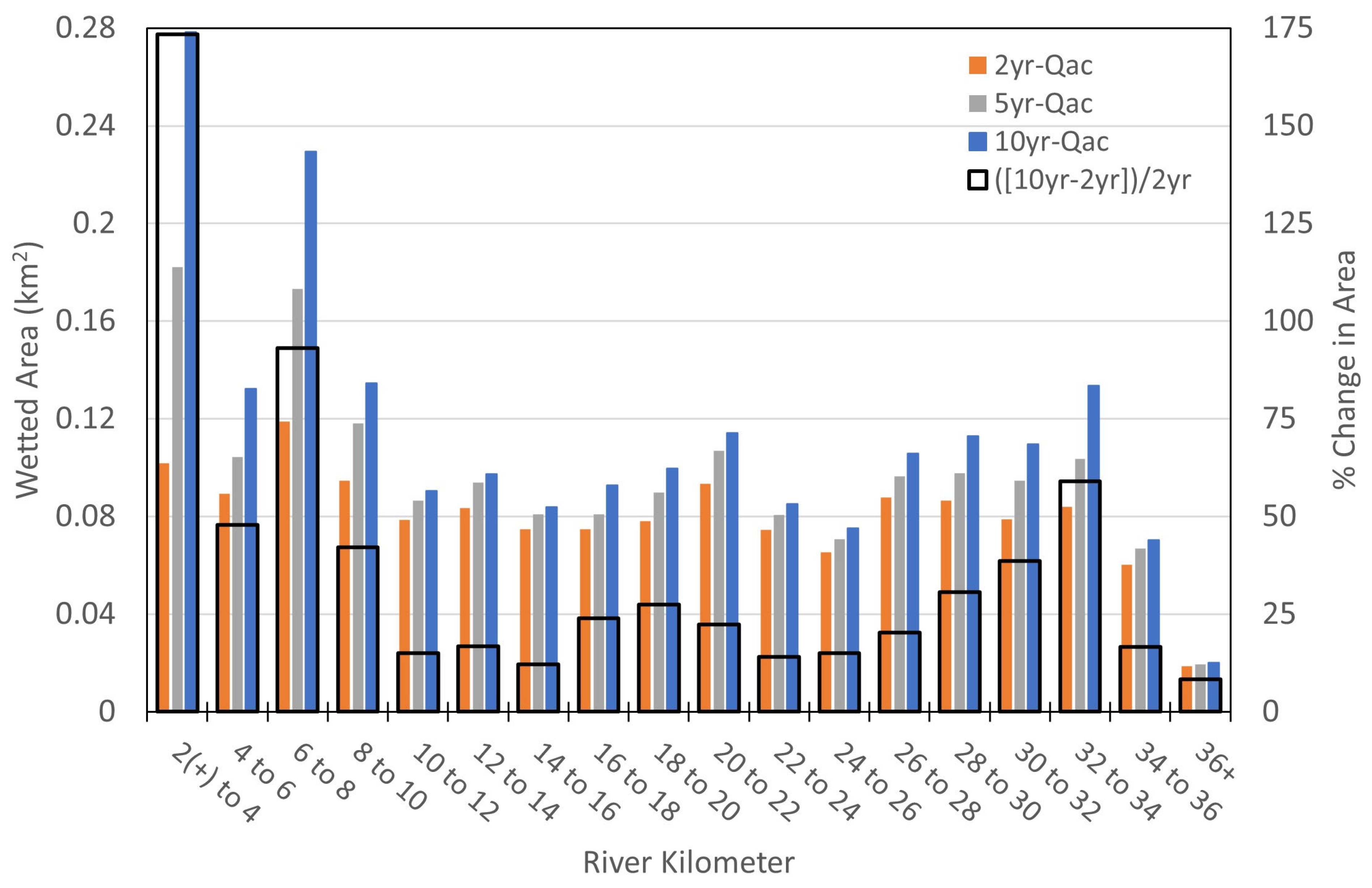
| Main channel inlet 1 | 15 | 257.7 | 339.8 | 393.6 | 458.7 | 509.7 |
| Manor Creek | 14 | 31.1 | 42.5 | 48.1 | 59.5 | 65.1 |
| Bull Creek 2 | 13 | 14.2 | 17.0 | 19.8 | 22.7 | 25.5 |
| Snahapish Creek | 12 | 11.3 | 8.5 | 14.2 | 11.3 | 11.3 |
| Deception Creek | 11 | 19.8 | 28.3 | 31.1 | 39.6 | 42.5 |
| Peterson Creek 3 | 10 | 8.5 | 11.3 | 14.2 | 14.2 | 19.8 |
| Christmas Creek | 9 | 51.0 | 65.1 | 76.5 | 93.4 | 101.9 |
| Miller Creek | 8 | 68.0 | 96.3 | 110.4 | 130.3 | 147.2 |
| Shale Creek | 7 | 36.8 | 51.0 | 56.6 | 68.0 | 73.6 |
| Mink Creek | 6 | 14.2 | 17.0 | 22.7 | 25.5 | 28.3 |
| Elkhorn Creek | 5 | 5.7 | 8.5 | 8.5 | 11.3 | 14.2 |
| Cougar Creek | 4 | 8.5 | 11.3 | 11.3 | 14.2 | 14.2 |
| Hunt Creek | 3 | 14.2 | 17.0 | 19.8 | 22.7 | 25.5 |
| Wild Cat Creek | 2 | 31.1 | 42.5 | 51.0 | 59.5 | 68.0 |
| Total Q (m3/s) | 572.0 | 756.1 | 877.8 | 1030.7 | 1146.8 | |
| Outlet WSE (m) 4 | 17.51 | 18.28 | 18.67 | 18.85 | 18.94 | |
| Time Period | Number of Peak Flows Exceeding Specified Magnitudes for Each Period | ||
|---|---|---|---|
| >566 m3/s (20,000 ft3/s) | 850 m3/s (30,000 ft3/s) | 1133 m3/s (40,000 ft3/s) | |
| 1931–1939 | 2 | 1 | 0 |
| 1940–1950 | 3 | 0 | 0 |
| 1951–1967, 1975–1980 1 | 13 | 4 | 0 |
| 1981–2006 | 17 | 4 | 1 |
| 2007–2017 | 6 | 1 | 0 |
| 2018–2019 | 0 | 0 | 0 |
3.3. Relative Elevation Maps
4. Results
4.1. Geomorphic Mapping
4.2. Hydraulic Modeling
4.3. Relative Elevations Maps
5. Discussion
5.1. Geomorphic Diversity and Potential Anthropogenic Change
5.2. Dual-Approach Channel Reconnection Identification
6. Conclusions
Supplementary Materials
Author Contributions
Funding
Data Availability Statement
Acknowledgments
Conflicts of Interest
References
- Cederholm, C.J.; Salo, E.O. The Effects of Logging Road Landslide Siltation on the Salmon and Trout Spawning Gravels of Stequaleho Creek and the Clearwater River Basin, Jefferson County, Washington, 1972–1978; Final Report—Part III; University of Washington: Seattle, WA, USA, 1979. [Google Scholar]
- Lestelle, L. Strategic Priorities for Habitat Management to Improve the Freshwater Performance of Queets Coho Salmon; Report delivered to the Quinault Indian Nation: Taholah, WA, USA, 2009. [Google Scholar]
- Dominguez, L. Predictions of Coho Salmon (Orcorhynchus kisutch) Population Abundance in the Clearwater River, Washington Using Various Habitat-Rating Scenarios of the Ecoysystem Diagnosis and Treatment Method. Ph.D. Thesis, Evergreen State College, Olympia, WA, USA, 2006. [Google Scholar]
- Quinault Indian Nation. WRIA 21 Queets/Quinault Salmon Habitat Recovery Strategy; Quinault Indian Nation Lead Entity: Taholah, WA, USA, 2011. [Google Scholar]
- Cederholm, C.J.; Reid, L.M.; Salo, E.O. Cumulative Effects of Logging Road Sediment on Salmonid Populations in the Clearwater River, Jefferson Country, Washington. In Proceedings of the Conference: “Salmon-Spawning Gravel: A Renewable Resource in the Pacific Northwest?”, Contribution No. 543, Seattle, WA, USA, 6–7 October 1980; p. 35. [Google Scholar]
- Reid, L.M.; Dunne, T. Sediment Production from Forest Road Surfaces. Water Resour. Res. 1984, 20, 1753–1761. [Google Scholar] [CrossRef]
- Brown, G.W.; Krygier, J.T. Clear-Cut Logging and Sediment Production in the Oregon Coast Range. Water Resour. Res. 1971, 7, 1189–1198. [Google Scholar] [CrossRef]
- Platts, W.S.; Torquemada, R.J.; McHenry, M.L.; Graham, C.K. Changes in Salmon Spawning and Rearing Habitat from Increased Delivery of Fine Sediment to the South Fork Salmon River, Idaho. Trans. Am. Fish. Soc. 1989, 118, 274–283. [Google Scholar] [CrossRef]
- Cederholm, C.J.; Reid, L.M. Impact of Forest Management on Coho Salmon (Oncorhynchus kisutch) Populations of the Clearwater River, Washington: A Project Summary. In Streamside Management Forestry and Fishery Interactions; Salo, E.O., Cundy, T.W., Eds.; University of Washington, Institute of Forest Resources: Seattle, WA, USA, 1987; pp. 373–397. [Google Scholar]
- Kreutzweiser, D.P.; Capell, S.S.; Good, K.P. Effects of Fine Sediment Inputs from a Logging Road on Stream Insect Communities: A Large-Scale Experimental Approach in a Canadian Headwater Stream. Aquat. Ecol. 2005, 39, 55–66. [Google Scholar] [CrossRef]
- Murphy, M.L.; Koski, K.V. Input and Depletion of Woody Debris in Alaska Streams and Implications for Streamside Management. North Am. J. Fish. Manag. 1989, 9, 427–436. [Google Scholar] [CrossRef]
- Wohl, E. A Legacy of Absence. Prog. Phys. Geogr. Earth Environ. 2014, 38, 637–663. [Google Scholar] [CrossRef]
- Cianfrani, C.M.; Sullivan, S.M.P.; Hession, W.C.; Watzin, M.C. Mixed Stream Channel Morphologies: Implications for Fish Community Diversity. Aquat. Conserv. Mar. Freshw. Ecosyst. 2009, 19, 147–156. [Google Scholar] [CrossRef]
- Abbe, T.B.; Montgomery, D.R. Patterns and Processes of Wood Debris Accumulation in the Queets River Basin, Washington. Geomorphology 2003, 51, 81–107. [Google Scholar] [CrossRef]
- Wegmann, K.W.; Pazzaglia, F.J. Holocene Strath Terraces, Climate Change, and Active Tectonics: The Clearwater River Basin, Olympic Peninsula, Washington State. Bull. Geol. Soc. Am. 2002, 114, 731–744. [Google Scholar] [CrossRef]
- Wing, M.G.; Skaugset, A. Relationships of Channel Characteristics, Land Ownership, and Land Use Patterns to Large Woody Debris in Western Oregon Streams. Can. J. Fish. Aquat. Sci. 2002, 59, 796–807. [Google Scholar] [CrossRef]
- Peters, R.J.; Knudsen, E.E.; Pauley, G.B.; Cederholm, C.J. Influence of Wood and Other Habitat Characteristics on the Distribution and Abundance of Coho Salmon in a Relatively Large River. Northwest Sci. 2015, 89, 336–354. [Google Scholar] [CrossRef]
- Smith, K.; Hanson, K.; Malone, L. Clearwater Forest Stewardship Plan, (Completed 2013; Revised 2015); Report produced by the Nature Conservancy (TNC) and Northwest Natural Resource Group; Nature Conservancy (TNC): Jefferson County, WA, USA, 2015. [Google Scholar]
- Remo, J.W.F.; Giri, T.L. Assessing Geomorphic and Hydraulic Changes Related to an Unplanned Reconnection of the Middle Mississippi River and Its Floodplain near Miller City, Illinois, USA. Geomorphology 2024, 449, 109062. [Google Scholar] [CrossRef]
- Pavesi, L.; D’Angelo, C.; Volpi, E.; Fiori, A. RESCUE: A Geomorphology-Based, Hydrologic-Hydraulic Model for Large-Scale Inundation Mapping. J. Flood Risk Manag. 2022, 15, e12841. [Google Scholar] [CrossRef]
- Wheaton, J.M.; Brasington, J.; Darby, S.E.; Merz, J.; Pasternack, G.B.; Sear, D.; Vericat, D. Linking Geomorphic Changes to Salmonid Habitat at a Scale Relevant to Fish. River Res. Appl. 2010, 26, 469–486. [Google Scholar] [CrossRef]
- Powers, P.; Staab, B.; Cluer, B.; Thorne, C. Rediscovering, Reevaluating, and Restoring Entiatqua: Identifying Pre-Anthropocene Valleys in North Cascadia, USA. River Res. Appl. 2022, 38, 1527–1543. [Google Scholar] [CrossRef]
- Annis, A.; Nardi, F. GFPLAIN and Multi-Source Data Assimilation Modeling: Conceptualization of a Flood Forecasting Framework Supported by Hydrogeomorphic Floodplain Rapid Mapping. Hydrology 2021, 8, 143. [Google Scholar] [CrossRef]
- James, L.A.; Hodgson, M.E.; Ghoshal, S.; Latiolais, M.M. Geomorphic Change Detection Using Historic Maps and DEM Differencing: The Temporal Dimension of Geospatial Analysis. Geomorphology 2012, 137, 181–198. [Google Scholar] [CrossRef]
- Grabowski, R.C.; Gurnell, A.M. Using Historical Data in Fluvial Geomorphology. In Tools in Fluvial Geomorphology; Wiley: Hoboken, NJ, USA, 2016; pp. 56–75. [Google Scholar]
- Foster, M.A.; Godaire, J.E.; Hilldale, R.C.; Bradley, D.N.; Boyd, K. Declining Geomorphic Diversity and Potential Adaptive Management Opportunities on a Highly Regulated Reach of the Bighorn River, Montana. Int. J. River Basin Manag. 2024, 23, 555–570. [Google Scholar] [CrossRef]
- Pazzaglia, F.J.; Brandon, M.T. A Fluvial Record of Long-Term Steady-State Uplift and Erosion across the Cascadia Forearc High, Western Washington State. Am. J. Sci. 2001, 301, 385–431. [Google Scholar] [CrossRef]
- PRISM, 2012 Is the Listed Citation for the 1981–2010 30 Yr Normals. Oregon State University. Available online: https://prism.oregonstate.edu (accessed on 1 July 2023).
- Bull, W.B. Stream-Terrace Genesis: Implications for Soil Development. Geomorphology 1990, 3, 351–367. [Google Scholar] [CrossRef]
- Meyer, G.A.; Wells, S.G.; Jull, A.J.T. Fire and Alluvial Chronology in Yellowstone National Park: Climatic and Intrinsic Controls on Holocene Geomorphic Processes. Geol. Soc. Am. Bull. 1995, 107, 1211–1230. [Google Scholar] [CrossRef]
- Wegmann, K.W. Late Quaternary Fluvial and Tectonic Evolution of the Clearwater River Basin, Western Olympic Mountains, Washington State. Ph.D. Thesis, University of New Mexico, Albuquerque, NM, USA, 1999. [Google Scholar]
- Fiksdal, A.J.; Brunengo, M.J. Forest Slope Stability Project-Phase II, WDOE 81-14; Washington State Department of Natural Resources (DNR): Olympia, WA, USA, 1981. [Google Scholar]
- Washington State Landslide Inventory Database. WDGER (Washington Division of Geology and Earth Resources). Available online: https://geologyportal.dnr.wa.gov/2d-view#wigm?-14056695,-12882622,5745536,6302609 (accessed on 22 June 2023).
- Pomeroy, J. Clearwater River Historical Aerial Photography Processing Documentation for the Quinault Department of Fisheries. Technical Memorandum; U.S. Department of the Interior, Bureau of Reclamation: Denver, CO, USA, 2020. Available online: https://data.usbr.gov/catalog/8042 (accessed on 22 June 2023).
- Lai, Y.G. SRH-2D Version 2: Theory and User’s Manual; US Department of the Interior, Bureau of Reclamation: Denver, CO, USA, 2008. [Google Scholar]
- Lai, Y.G. Two-Dimensional Depth-Averaged Flow Modeling with an Unstructured Hybrid Mesh. J. Hydraul. Eng. 2010, 136, 12–23. [Google Scholar] [CrossRef]
- Shields, A. Application of Similarity Principles and Turbulence Research to Bedload Movement; Translated from German; California Institute of Technology: Pasadena, CA, USA, 1936. [Google Scholar]
- Vanoni, V.A. Sedimentation Engineering; ASCE Manual 54; ASCE: New York, NY, USA, 1975. [Google Scholar]
- Wright, J. Clearwater River Watershed Flood Frequency Analysis, Report No. ENV-2021-048; US Department of the Interior, Bureau of Reclamation: Denver, CO, USA, 2020. Available online: https://data.usbr.gov/catalog/8042 (accessed on 22 June 2023).
- Mastin, M.C.; Konrad, C.P.; Veilleux, A.G.; Tecca, A.E. Magnitude, Frequency, and Trends of Floods at Gaged and Ungaged Sites in Washington, Based on Data Through Water Year 2014; Scientific Investigations Report No. 2016-5118; US Geological Survey: Reston, VA, USA, 2016. [Google Scholar]
- Olson, P.L.; Legg, N.T.; Abbe, T.B.; Reinhart, M.A.; Radloff, J.K. A Methodology for Delineating Planning-Level Channel Migration Zones; No. 14-06-025; Washington State Department of Ecology: Olympia, WA, USA, 2014. [Google Scholar]
- Greco, S.E.; Girvetz, E.H.; Larsen, E.W.; Mann, J.P.; Tuil, J.L.; Lowney, C. Relative Elevation Topographic Surface Modelling of a Large Alluvial River Floodplain and Applications for the Study and Management of Riparian Landscapes. Landsc. Res. 2008, 33, 461–486. [Google Scholar] [CrossRef]
- Hagans, D.K.; Weaver, W.E.; Madej, M.A. Long-Term on-Site and off-Site Effects of Logging Sand Erosion in the Redwood Creek Basin, Northern California; Technical Bulletin; National Council of the Paper Industry for Air and Stream Improvement: New York, NY, USA, 1986; Volume 490, pp. 38–66. Available online: https://pubs.usgs.gov/publication/70006754 (accessed on 14 November 2025).
- Swanson, F.J.; Benda, L.E.; Duncan, S.H.; Grant, G.E.; Megahan, W.F.; Reid, L.M.; Ziemer, R.R. Mass Failures and Other Processes of Sediment Production in Pacific Northwest Forest Landscapes. In Streamside Management: Forestry and Fishery Interactions, Proceedings of the Symposium Held at University of Washington, Seattle, WA, USA, 12–14 February 1986; Salo, E.O., Cundy, T.W., Eds.; Institute of Forest Resources: Seattle, WA, USA, 1987; pp. 9–38. [Google Scholar]
- Wohl, E.E. Messy Rivers Are Healthy Rivers: The Role of Physical Complexity in Sustaining Ecosystem Processes. In Proceedings of the River Flow—Proceedings of the International Conference on Fluvial Hydraulics, RIVER FLOW 2016, Saint-Louis, MO, USA, 10–15 July 2016; Taylor & Francis: Iowa City, IA, USA, 2016; pp. 24–29. [Google Scholar]
- Everall, N.C.; Farmer, A.; Heath, A.F.; Jacklin, T.E.; Wilby, R.L. Ecological Benefits of Creating Messy Rivers. Area 2012, 44, 470–478. [Google Scholar] [CrossRef]
- Brooks, S.M.; Richards, K.S.; Nussbaum, R. Simulator Experiments of the Varied Consequences of Rain Forest Logging for Runoff and Erosion. Geogr. Ann. Ser. A Phys. Geogr. 1994, 76, 143–152. [Google Scholar] [CrossRef]
- Wright, K.A.; Sendek, K.H.; Rice, R.M.; Thomas, R.B. Logging Effects on Streamflow: Storm Runoff at Caspar Creek in Northwestern California. Water Resour. Res. 1990, 26, 1657–1667. [Google Scholar] [CrossRef]
- Chapman, W.A.L.; Finnegan, N.J. The Signature of Climate in Fluvial Suspended Sediment Records. J. Geophys. Res. Earth Surf. 2024, 129, e2023JF007429. [Google Scholar] [CrossRef]
- Peterson, N.P.; Reid, L.M. Wall-Base Channels: Their Evolution, Distribution and Use by Juvenile Coho Salmon in the Clearwater River, Washington. In Proceedings of the Olympic Wild Fish Conference, Peninsula College Fisheries Technology Program, Port Angeles, WA, USA, 23–25 March 1983; Walton, J.M., Houston, D.B., Eds.; Olympic National Park and Peninsula College: Port Angeles, WA, USA, 1983; pp. 215–225. [Google Scholar]
- Wohl, E. Rivers in the Anthropocene: The U.S. Perspective. Geomorphology 2020, 366, 106600. [Google Scholar] [CrossRef]
- Wohl, E.; Rathburn, S.; Dunn, S.; Iskin, E.; Katz, A.; Marshall, A.; Means-Brous, M.; Scamardo, J.; Triantafillou, S.; Uno, H. Geomorphic Context in Process-based River Restoration. River Res. Appl. 2024, 40, 322–340. [Google Scholar] [CrossRef]
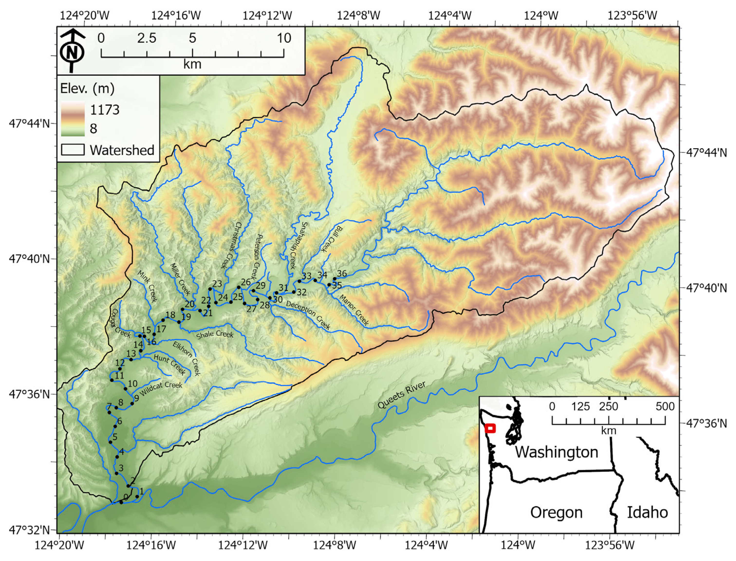
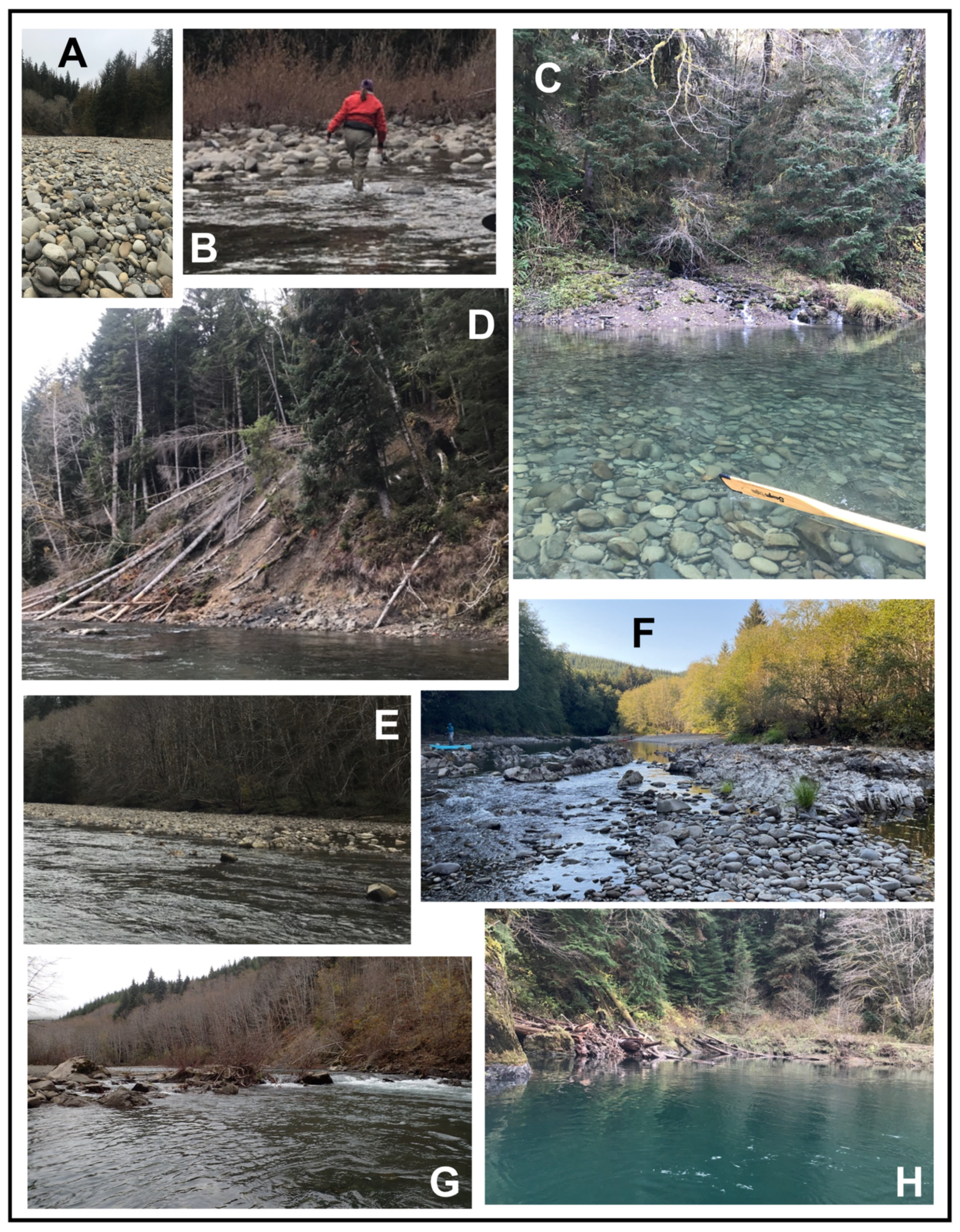




| Year | Resolution |
|---|---|
| 1939 | 1:30,000, 25-micron digital scan of single photos |
| 1950 | 1:37,400, 25-micron digital scan of single photos |
| 1980 | 1:20,000, 25-micron digital scan of single photos, from the Clearwater River Mouth (r-km 0) to Miller Creek tributary confluence (near r-km 20.5) 1:24,000, 40-micron digital scan of single photos, upstream from Miller Creek |
| 1994 | Digital Orthophoto Quadrangles (DOQ), typically 1 m resolution |
| 2006 | High Resolution Orthophoto, typically 1 m or finer resolution |
| 2017 | National Agriculture Imagery Program (NAIP), typically 1 m resolution |
| Year | 1939 | 1950 | 1980 | 1994 | 2006 | 2017 |
|---|---|---|---|---|---|---|
| Unit area within Active Geomorphic Corridor (106 m2) | ||||||
| Qac | 1.02 | 1.00 | 1.12 | 1.03 | 1.09 | 0.94 |
| Qsc | 0.06 | 0.04 | 0.06 | 0.06 | 0.07 | 0.06 |
| Qoc | 0.07 | 0.06 | 0.10 | 0.05 | 0.05 | 0.17 |
| Qocmodel | n/a | n/a | n/a | n/a | n/a | 0.11 |
| Qalbare (Qb2) | 0.59 | 0.78 | 0.33 | 0.32 | 0.31 | 0.38 |
| Qfan | <0.01 | <0.01 | <0.01 | <0.01 | <0.01 | <0.01 |
| Qalveg (Qb1) | 0.07 | 0.19 | 0.33 | 0.41 | 0.33 | 0.52 (0.38) 1 |
| All Units | 1.83 | 2.08 | 1.94 | 1.86 | 1.86 | 2.17 (1.92) 1 |
| Unit Area of modern, vegetated alluvium outside of Active Geomorphic Corridor (106 m2) | ||||||
| Qalveg (Disconnected) | n/a | 0.42 | 0.64 | 0.95 | 0.96 | 0.89 |
| Qalveg (Other) 2 | 0.02 | 0.11 | 0.30 | 0.17 | 0.24 | 0.17 |
| Unit area of all modern, vegetated alluvium, within and outside of geomorphic corridor (106 m2) | ||||||
| 0.09 | 0.72 | 1.28 | 1.54 | 1.52 | 1.57 | |
| Unit area of Qt7, youngest Holocene terrace, within and outside of geomorphic corridor (106 m2) 3 | ||||||
| 0.77 | 0.44 | 0.32 | 0.30 | 0.28 | 0.27 | |
| Reach, (r-km Range) | Side Channels, Qsc 1 | Overflow Channels, Qoc (Qoc + Qocmodel) 1,2 | ||
|---|---|---|---|---|
| 1939 | 2017 | 1939 | 2017 | |
| 1.8–10 | 8 | 4 | 12 | 12 (25) |
| 10–16 | 9 | 3 | 2 | 3 (4) |
| 16–21 | 2 | 0 | 3 | 6 (6) |
| 21–30 | 10 | 6 | 6 | 6 (10) |
| 30–35 | 3 | 6 | 2 | 4 (10) |
| 35–37.3 | 0 | 1 | 3 | 3 (3) |
| Landslides 1 | 1939 | 1950 | 1980 | 1994 | 2006 | 2017 | 2022 Lidar | Wegmann (Late 90s) | Field Mapping | WDGER 2 |
|---|---|---|---|---|---|---|---|---|---|---|
| Area (103 m2) | 83 | 77 | 30 | 4 | 33 | 173 | 123 | 321 | 26 | 4924 |
| Prioritization for Further Analysis | Reach, r-km | Considerations for Success |
|---|---|---|
| 1 | Below 10 |
|
| 2 | 25 to 30 |
|
| 3 | 30 to 36 |
|
| 4 | 15 to 25 |
|
| 5 | 10 to 15 |
|
Disclaimer/Publisher’s Note: The statements, opinions and data contained in all publications are solely those of the individual author(s) and contributor(s) and not of MDPI and/or the editor(s). MDPI and/or the editor(s) disclaim responsibility for any injury to people or property resulting from any ideas, methods, instructions or products referred to in the content. |
© 2025 by the authors. Licensee MDPI, Basel, Switzerland. This article is an open access article distributed under the terms and conditions of the Creative Commons Attribution (CC BY) license (https://creativecommons.org/licenses/by/4.0/).
Share and Cite
Connor, E.G.; Foster, M.A.; Bountry, J.A. Integrated Geomorphic Mapping and Hydraulic Modeling to Identify Potential Channel Reconnection Sites for Alternatives Analysis on the Clearwater River, Washington, USA. Water 2025, 17, 3359. https://doi.org/10.3390/w17233359
Connor EG, Foster MA, Bountry JA. Integrated Geomorphic Mapping and Hydraulic Modeling to Identify Potential Channel Reconnection Sites for Alternatives Analysis on the Clearwater River, Washington, USA. Water. 2025; 17(23):3359. https://doi.org/10.3390/w17233359
Chicago/Turabian StyleConnor, Erin G., Melissa A. Foster, and Jennifer A. Bountry. 2025. "Integrated Geomorphic Mapping and Hydraulic Modeling to Identify Potential Channel Reconnection Sites for Alternatives Analysis on the Clearwater River, Washington, USA" Water 17, no. 23: 3359. https://doi.org/10.3390/w17233359
APA StyleConnor, E. G., Foster, M. A., & Bountry, J. A. (2025). Integrated Geomorphic Mapping and Hydraulic Modeling to Identify Potential Channel Reconnection Sites for Alternatives Analysis on the Clearwater River, Washington, USA. Water, 17(23), 3359. https://doi.org/10.3390/w17233359


