Article

Management of Urban Water Landscape Facilitating Multi-Layer Water Sports: Subjective Perception and Objective Evidence

1
School of Architecture, Nanjing Tech University, Nanjing 211816, China
2
Shanghai Hongyang Landscape Greening Engineering Co., Ltd., Shanghai 201100, China
3
College of Architecture and Urban Planning, Tongji University, Shanghai 200092, China
4
Future City (Shanghai) Design Consulting Co., Ltd., Shanghai 200082, China
5
Department of Physical Education and Sport, Shanghai Ocean University, Shanghai 200120, China
*
Author to whom correspondence should be addressed.
Water 2025, 17(22), 3292; https://doi.org/10.3390/w17223292
Submission received: 8 October 2025 / Revised: 9 November 2025 / Accepted: 14 November 2025 / Published: 18 November 2025

Abstract

In the context of national fitness and ecological construction, urban water, as the core carrier of water sports, is increasingly being explored. Through empirical analysis of urban water bodies in Nanjing and Shanghai, the Spearman model and an XGBoost model, based on SHAP, are used to examine the correlation between the subjective perceptions of water-landscape images by various types of water-sports participants and objective evidence of urban water-landscape elements. The results show that amateurs prefer a high green-view index (>20%) + low water visibility (≤30%) + low sky visibility (≤30%) + shallow-water area (≤1.5 m), which enhances their satisfaction with the leisure experience; progressors prefer a moderate green-view index (10–20%) + moderate water visibility (30–40%) + moderate sky visibility (30–40%) + medium water-depth area (1.5–2.5 m), which helps them achieve better perception of skill improvement and training effectiveness; professionals prefer high water visibility (≥40%) + high sky visibility (≥40%) + low green-view index (≤10%) + deep-water area (≥2.5 m), which meets their training requirements for professional competitions. This study provides a scientific basis for urban water landscape planning and design in order to create urban water sports spaces that respond to the needs of various types of water sports participants.

1. Introduction

1.1. Background

Under the guidance of China’s ecological civilization construction strategy [1], national initiatives such as Beautiful China and Park City continue to promote the ecological reshaping and functional improvement of urban water landscapes. The relevant national standards further specify that water landscape development should coordinate multiple goals such as ecological protection, leisure and recreation, and sports and fitness, providing systematic guidance for practice. Under this policy background, urban water spaces have gradually developed into important carriers for outdoor activities and the promotion of public health [2,3]. An increasing number of studies have shown that outdoor sports in natural environment provide significant benefits for physical and mental health [4,5,6]. A natural environment provides support for achieving physiological and psychological balance, promoting human–nature connections and social–leisure interactions, and offering urban residents unique pathways to attain wellness and social value [7,8,9,10]. In recent years, urban water landscapes have emerged as important venues for outdoor sports due to their accessibility and environmental comfort [11]. In particular, non-motorized water sports such as paddle boarding and kayaking have been increasingly favored because of their easy operation, proximity to the nature, and suitability across all age groups [12]. These sports activities integrate physical training with natural experiences, demonstrating significant benefits at physiological, psychological, and social levels [13,14,15]. The realization of sports effects is influenced by the interaction between sports activities and environmental factors. Optimizing urban water landscapes in terms of aesthetic quality, ecological stability, and functional accessibility can enhance public health levels and stimulate residents’ participation enthusiasm [16,17,18]. Moreover, objective evidence indicators of urban water landscapes, including water visibility, green view index, and sky visibility, significantly influence participants’ subjective perception [19,20,21]. The public’s subjective perception of the environment has become a key indicator of urban water landscape quality, and its results can guide the planning and design of urban water landscapes [22,23]. The correlation between subjective perception and objective evidence has been confirmed as a critical factor in improving water sports experiences (Figure 1). Thorough understanding and optimization of this relationship can help establish a new paradigm for urban water landscape evaluation, providing a scientific basis for differentiated water landscape designs and promoting the coordinated development of national fitness and urban ecology [24,25,26].

1.2. Research Progress

In recent years, interdisciplinary research has continued to explore the correlation between the built environment and the public’s subjective perception. For example, based on questionnaire data from Shanghai residents, a two-level structural model of public sports space perception was established, revealing its intrinsic correlation with sports behaviors [27]. The empirical research on the Eindhoven Marathon in the Netherlands also showed that environmental characteristics exerted a significantly stronger incentive effect on sports participation than did individual motivation [28]. Environmental variables such as shading [29], green view index [30,31], pathway form [32], and landscape sequences [33,34] were all confirmed to exert positive effects on physical activities, with blue and green integration spaces demonstrating notable advantages for promoting recreational sports [35]. Studies on water sports have also been expanded. Empirical research based on “serious leisure inventory and measure (SLIM)” found that surfers exhibited environment-oriented preferences in regards to destination selection and were driven jointly by wave conditions and water ecological quality [36]. The study combining GPS and heart rate monitoring revealed that surfing ability, wave height, and period influence individual physiological responses and sports efficiency [37]. These findings provide a reference for urban water landscape planning.
However, current studies still exhibit limitations. Many of them focus on traditional land spaces such as streets and parks, lacking landscape experience analysis based on “water surface perspective”. Moreover, existing studies are mostly based on demographic variables such as age and gender to categorize sports participants, neglecting the differences in environment requirements of various types of water sports participants [38]. Although existing studies indicate that high-quality landscape environments are conducive to sports performance and psychological health, there is still a lack of systematic research on the correlation between objective evidence of urban water landscape elements such as green view index, sky visibility, and subjective perception of water landscape images by various types of water sports participants, particularly the response differences among various types of water sports participants at different skill levels. Existing theories are insufficient to support targeted and hierarchical practice design, limiting the construction of individualized urban water landscapes.
In addition, relevant studies remain at the theoretical level, lacking practical guidance for planning and design. There is an urgent need to integrate subjective perception and objective evidence, carry out interdisciplinary integration research, and establish a practical assessment framework and design strategies. Key scientific questions that urgently need to be addressed include the following: Which water landscape elements significantly influence subjective perception of water landscape images by various types of water sports participants? What are the commonalities and differences in subjective perception of water landscape images by various types of water sports participants? What structural characteristics do urban water landscapes exhibit? How can water landscapes be optimally configured to construct spatial scenarios that meet diverse requirements? Empirical support can be provided to address these problems by quantifying urban water landscapes and integrating them with subjective perception of water landscape images by various types of water sports participants, advancing the scientific planning and development of urban water sports spaces [39,40,41,42].
Regardless of whether participants are amateurs, progressors, or professionals, participant behaviors can be divided into three core stages: environmental attraction, training optimization, and recovery adaptation. Each stage involves specific physiological and psychological requirements which are significantly influenced by waterfront landscape features such as sky visibility and water visibility. Different water scenarios and their circumstance environment elements affect the perception and preferences of all participant groups. Therefore, the optimal water sports environment should provide scientifically configured water landscape elements to meet the demands of different participants.

1.3. Research Framework

In summary, this study attempts to employ three selected water bodies in Nanjing and Shanghai as examples in order to explore the relationship between water landscape and subjective perception of water sports participants by using subjective perception data with water landscape elements extracted from on-site water landscape images and quantitatively evaluate urban water landscapes. The specific contents include the following: (1) confirming the preferences of different participant groups and establishing a standardized method for water assessment; (2) identifying urban water landscape elements that influence subjective perception of water sports participants and their interrelationships; (3) constructing differentiated urban water landscapes from the perspective of landscape architecture.

2. Materials and Methods

2.1. Study Area and Study Subjects

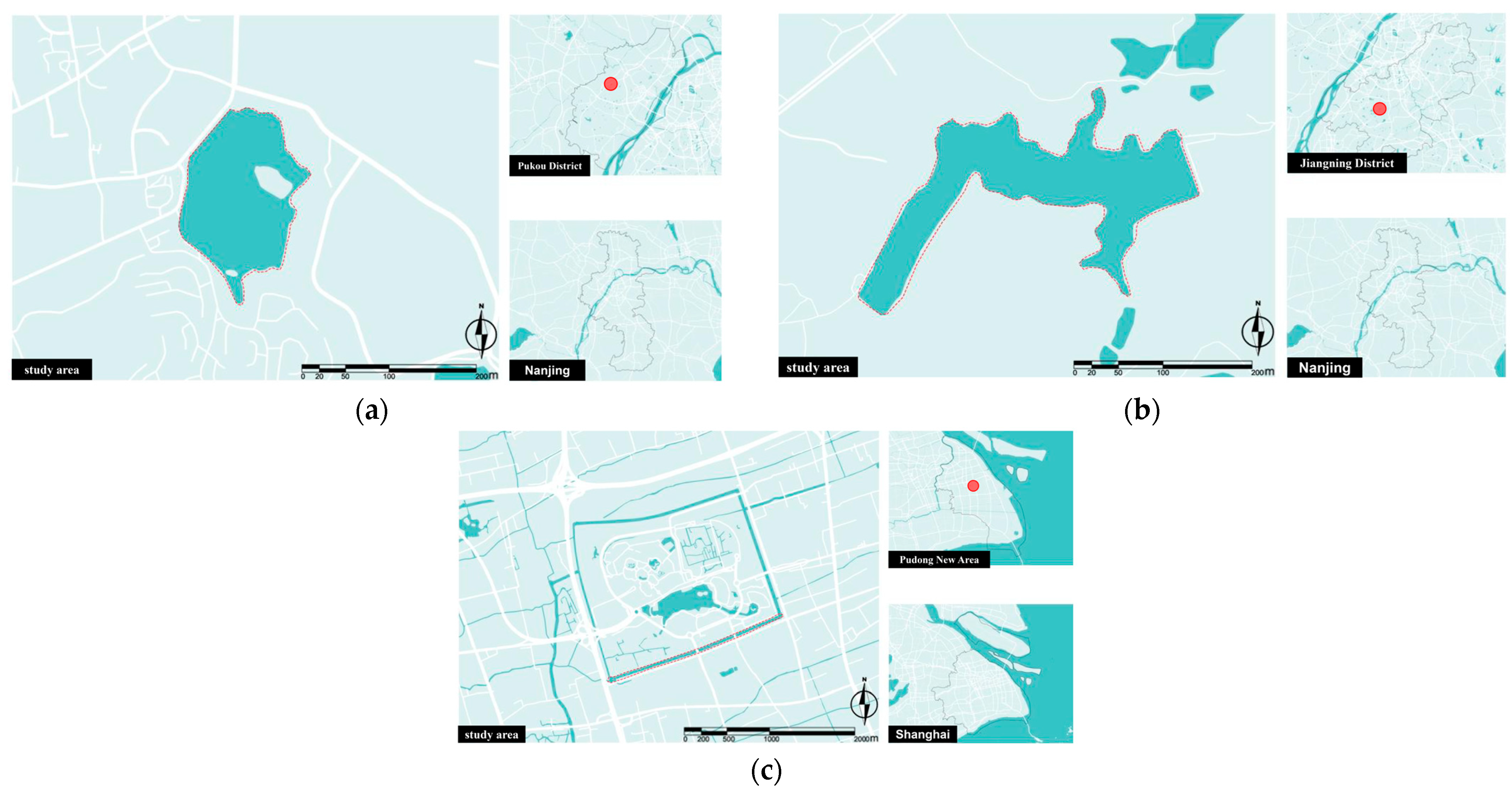
This paper focuses on three types of water sports participants, i.e., (1) amateurs: participants who engage in recreational activities without fixed sport frequency and training plans who can perform basic paddling and turning in calm water; (2) progressors: participants who train regularly and can complete skills such as the outer shaft turning of the board tail, translational steps on the board, and paddling continuously for over 1 km within 15 min; (3) professionals: participants who aim at competition and skill improvement and can perform complex movements in still water and wave areas, can continuously paddle for 1 km within 12 min, and can undertake endurance training for over 3 km. The study areas include Jiulong Lake in Pukou District, Nanjing; Bailu Lake in Jiangning District, Nanjing; and the southern section of Shendi Ring River in Pudong, Shanghai. The dashed line represents the specific range of the lake, and the red dot indicates the location of the lake in the city. The three study sites—Jiulong Lake, Bailu Lake, and Shendi Ring River—were selected for their representativeness of urban water landscapes in Nanjing and Shanghai, China, covering different developmentdal levels and accessibility for multi-layer water sports. Beyond representativeness, the sites were chosen based on hydrological rationales: Jiulong Lake offers moderate flow and depth, with open water and a tranquil environment for amateur activities; Bailu Lake provides calmer waters for progressive training; and Shendi River features stronger currents for professional sports. Ecologically, the sites differ in riparian vegetation and biodiversity. These factors ensure that the sites represent a range of conditions relevant to the study’s semantic segmentation and SHAP-based modeling. These areas are representative and provide empirical support for urban water landscape planning, design, and functional optimization (Figure 2).

2.2. Research Design

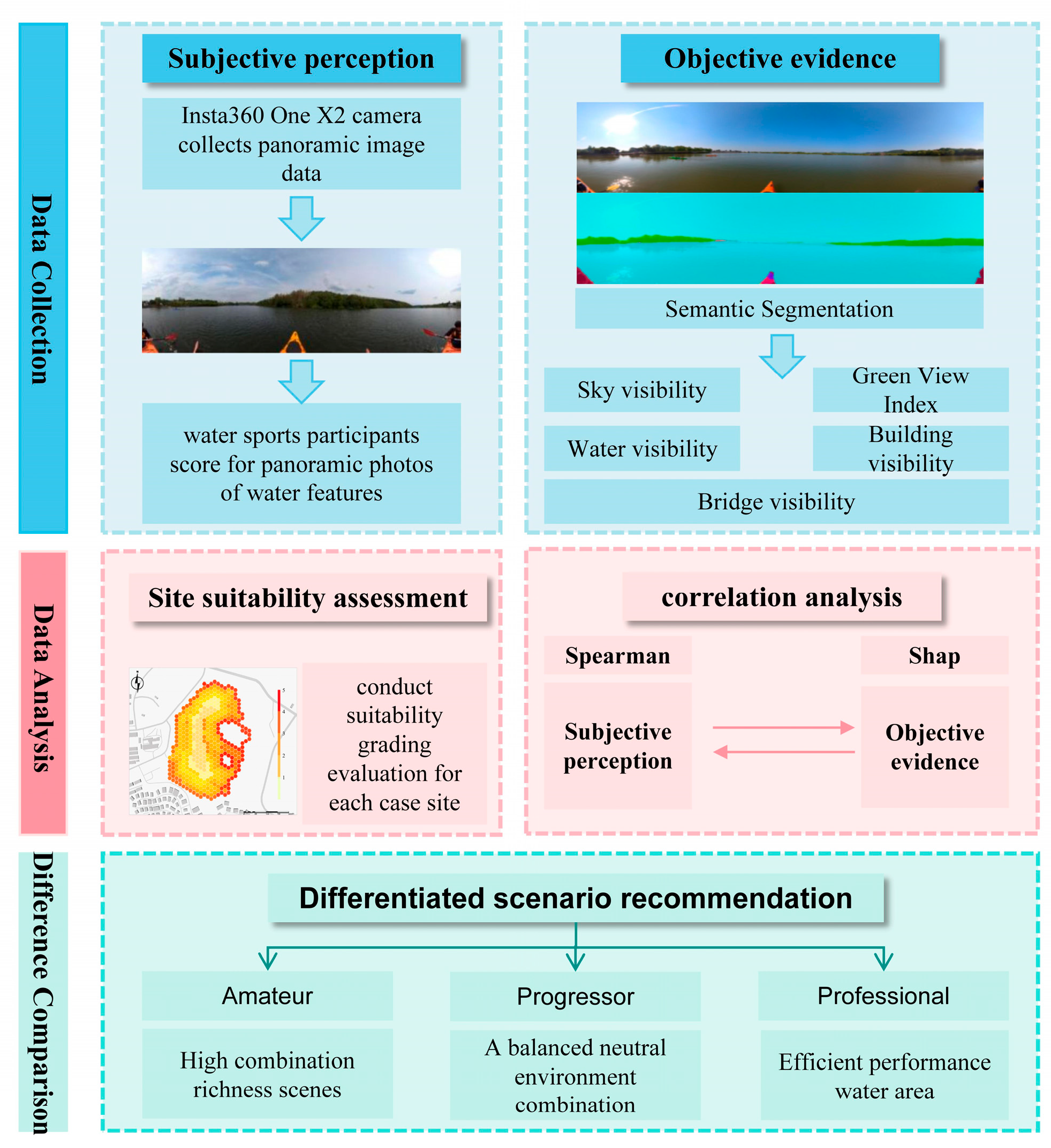
This study aims to explore the correlation between the subjective perception of water landscape images by various types of water sports participants and the objective evidence of urban water landscape elements. It is conducted in three steps, i.e., data collection, data analysis, and difference comparison. There are several substeps below each step. Specific flows are as follows: (1) water landscape images were collected at Jiulong Lake, Bailu Lake, and the southern section of Shendi Ring River using an Insta360 One X2 camera (Insta360 Co., Ltd., Shenzhen, China), selecting representative images to exhibit water characteristics; (2) 241 volunteers were recruited to score the water landscape images and obtain subjective perception data; (3) semantic segmentation was conducted for water landscape images to extract water landscape elements including sky, water, vegetation, buildings, and bridges; (4) a Spearman model and a SHAP-XGBoost model were used to explore the relationship between subjective perception and objective evidence; (5) based on the analysis results, urban water landscape scenarios for various types of water sports participants were constructed (Figure 3).

2.3. Data Collection and Processing

2.3.1. Objective Evidence Data Collection

Water landscape images were collected using an Insta360 One X2 panoramic camera at Jiulong Lake, Bailu Lake, and the southern section of Shendi Ring River. The photographing was conducted in May and July 2025. Seasonal differences between May and July in the Nanjing and Shanghai regions are minimal, as both months fall within the stable late spring to early summer transition, with consistent precipitation and temperature ranges that maintain hydrological stability. Consequently, these conditions result in negligible variations in water color, greening index, and visibility metrics. The Insta360 One X2 camera, renowned for its high-resolution 360° panoramic mode, provided clear and detailed images. Post-processing was conducted using Insta360 Studio to further optimize image quality. To prevent figures from affecting the image quality, the camera was mounted on the top of the photographer’s head. In the process of photographing, a specific path was selected, and photos were captured once every 10 m to ensure the continuity of the image sequence and comprehensively capture various types of urban water landscapes. After photographing, the images were spliced using Insta360 Studio, exporting panoramic images with a resolution of 6080 × 3040 pixels. For subsequent analysis, images were processed in batches to minimize the proportion of figures and boats, centering the water–land boundary line in the frame and exporting panoramic images with a resolution of 6080 × 2000 pixels. A total of 200 high-quality image samples were selected for subsequent semantic segmentation and urban water landscape element analysis.

2.3.2. Objective Evidence Data Processing

Semantic segmentation was conducted for panoramic images using Python 3.12.7. The analysis was performed on the PyCharm 2025.1.3.1 and Anaconda2024.10-1 platforms, employing the ADE20K dataset and the DeepLabv3+ model. The DeepLabv3+ model was proposed by Chen et al. and the Google team in 2014 and is a model specifically designed for processing semantic segmentation. This model currently provides the most innovative and excellent series of segmentation algorithms in the field of semantic segmentation [43]. The ADE20K dataset, which is widely used for complex scenario segmentation, achieves an accuracy of 82.4% [44]. The DeepLabv3+ model, which is optimized through deep convolutional neural networks, effectively captures contextual information and universal background, reduces false segmentation, and improves precision [45]. Based on this optimization, panoramic water images were segmented into key urban water landscape elements including sky, water, vegetation, buildings, and bridges (Supplementary File S1), providing reliable data support for objective evidence (Figure 4).

2.3.3. Subjective Perception Data Collection

In the volunteer recruitment process, to ensure the relevance of the research data to practical water sports, we strictly defined the participants’ physical conditions and educational background. Specifically, all volunteers were selected from the height range suitable for common water sports such as stand-up paddling and kayaking (165–190 cm for males, 155–180 cm for females). This range was determined by comprehensively considering factors such as the ease of equipment operation, the ability to maintain body balance, and sports safety, based on relevant research recommendations. Furthermore, questionnaire screening ensured that respondents fell within this height range, thereby making their perceptual evaluations of aquatic spaces more practically relevant.
Concurrently, to ensure that respondents could accurately understand the complex landscape evaluation indicators and provide effective feedback, the educational background of all volunteers was required to be at the bachelor’s degree level or above. This measure aims to ensure that participants possess adequate cognitive and judgmental abilities to rationally and consistently evaluate landscape elements (such as green view index, water visibility, etc.) in waterscape images, thereby enhancing the quality and reliability of the perceptual evaluation data.
A total of 241 volunteers scored the panoramic images to collect subjective perception data from various types of water sports participants. The gender proportion of volunteers was 1:1, with an average age of 27. The proportion of amateurs, progressors, and professionals was 8:1:1, reflecting actual distribution. Basic participant information, including gender, age, sports frequency, experience, and training level, was recorded, providing a basis for subsequent analysis.
The study employed the space division unit (SDU) as a basic unit for assessing urban water landscapes, with the size set to three times the length of a single-person kayak (approximately 1.56 m × 3). The SDU is used to delineate the active areas of urban water, ensuring the consistency of spatial scale. In the assessment, SDU scores were expressed through color saturation, with the depth of color indicating the score level, serving as a basis for the correlation analysis between subjective perception and objective evidence [46,47] (Table 1).

2.3.4. Correlation Between Subjective Perception and Objective Evidence

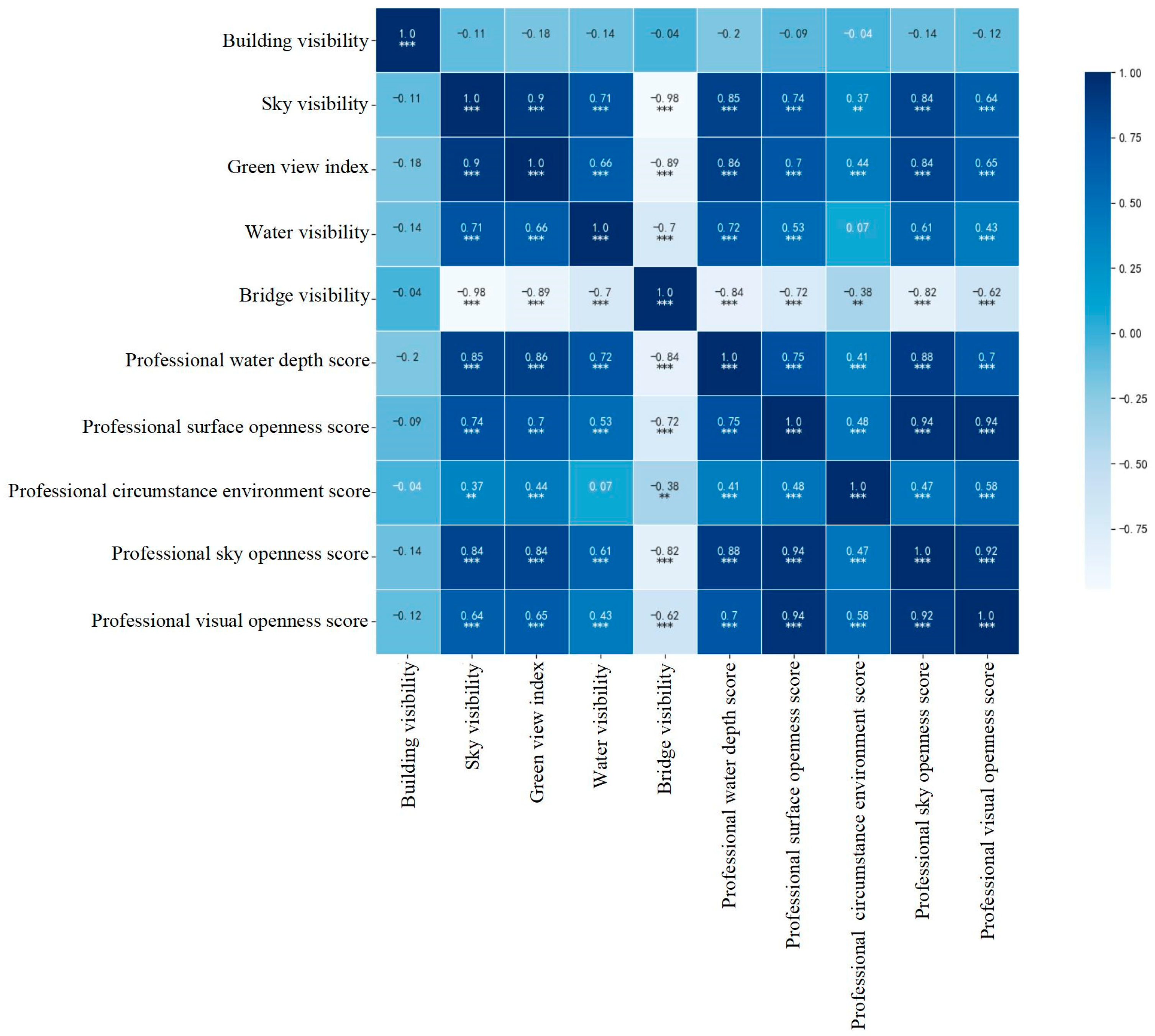
The Spearman model and the SHAP-based XGBoost model were adopted to explore the correlation between the subjective perception of water landscape images by various types of water sports participants and the objective evidence of urban water landscape elements (Table 2). Spearman correlation analysis, which does not rely on data distribution, is widely applied in environmental and sports fields. The correlation coefficient matrix was visualized using Python’s Matplotlib and Seaborn libraries, with heat maps generated to intuitively display the correlation among variables. Correlation was expressed in blue, with deeper color indicating stronger coefficients, and the correlations of statistical significance were marked as * p < 0.1, ** p < 0.05, and *** p < 0.01.
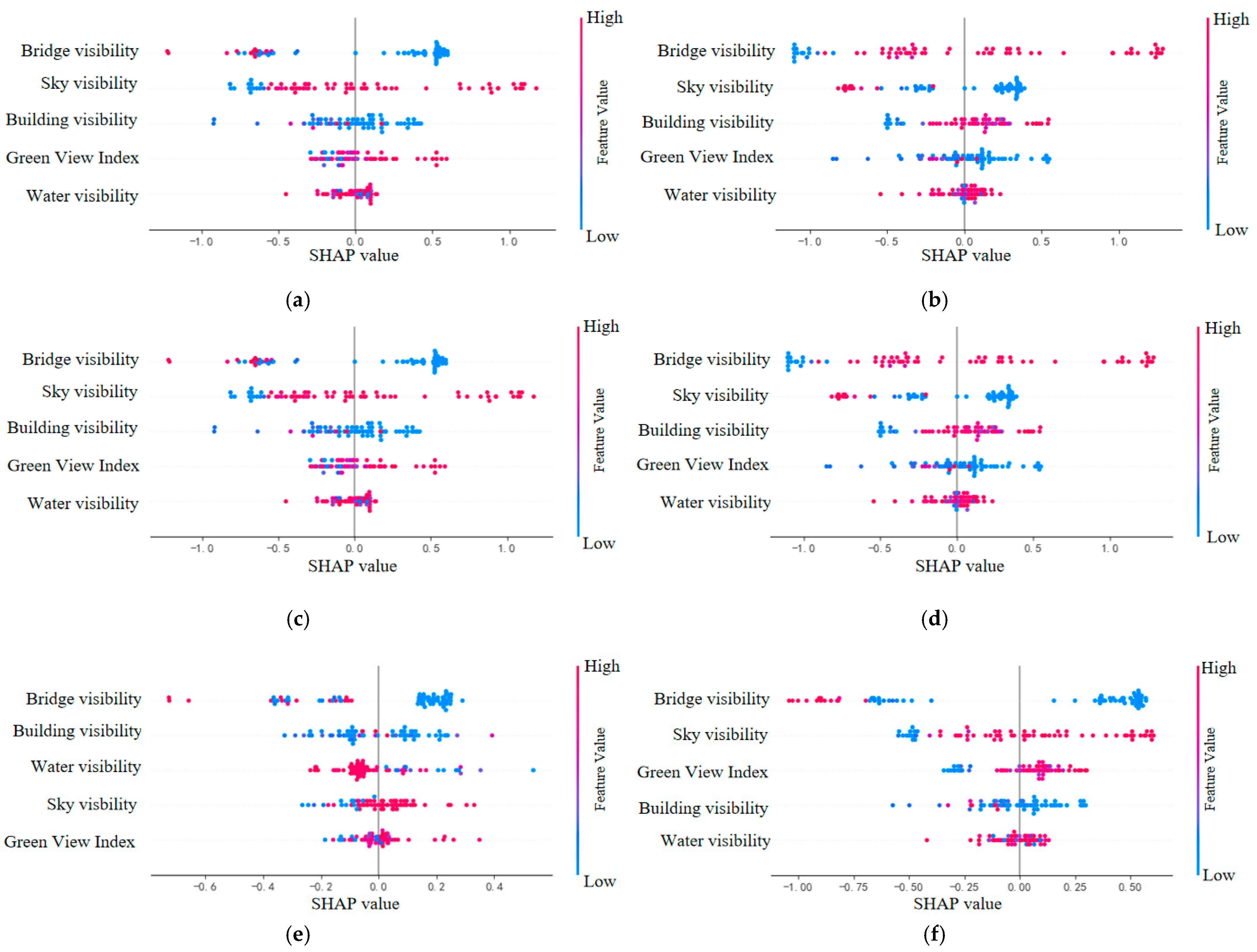
To specifically analyze the influence of the urban water landscape on the subjective perception of various types of water sports participants, the explanation chart for the XGBoost model, based on SHAP, was drawn. The horizontal axis represents SHAP values, indicating the influence of features on the prediction, with larger values reflecting more significant positive or negative effects. The vertical axis represents feature importance ranking, reflecting the overall contribution of the elements. In the chart, each point represents a sample, with its position indicating the specific influence of the sample’s feature value on the prediction outcome, and the distribution revealing the mechanism by which different feature values influence the subjective scores. In this study, it is used for global and local interpretability analysis, assessing the influence of different urban water landscapes on the subjective perception of various types of water sports participants [48,49].

3. Results

3.1. Site Scoring Results

To ensure the validity of constraint factor evaluation, SPSS 25 was applied for statistical analysis of the returned questionnaire data. The standardized Cronbach’s α coefficient was 0.948 (>0.9), indicating a high level of reliability and validity and showing strong internal consistency between observable variables and latent variables. The KMO test yielded a value of 0.816 (>0.8), indicating the appropriateness of the dataset for information extraction. Meanwhile, independent sample tests were conducted based on the grouping of water sports venues. The Levene’s test values for the variance equations of each element were all greater than 0.05, indicating approximate normal distribution and homogeneity of variance across questionnaire data. These results demonstrate that differences in selected water sports venues did not significantly affect participants’ subjective perception, affirming their universality.
In the scoring process for amateurs, safety, comfort, and sensory pleasure are the core considerations. Amateurs tend to engage in low-intensity sports, emphasizing physical and mental relaxation. When urban water landscapes feature rich vegetation, clear water, shallow water depth, and calm surface, subjective scores from amateurs are higher. These factors help create a tranquil and safe environment, reduce anxiety, and improve the overall sports experience.
Progressors place great emphasis on the functionality and adaptability of urban water landscapes, particularly those that support skill development. Large water surface, moderate water depth, and water boundaries and facilities aligned with training needs generally result in high subjective scores from progressors.
Professionals prioritize the professionalism and competition conditions of urban water landscapes, particularly the environments that support high-intensity training and competitions. The spaces with wider visual openness and fewer obstacles can significantly increase the scores of professionals.

3.2. Site Suitability Scoring and Grading

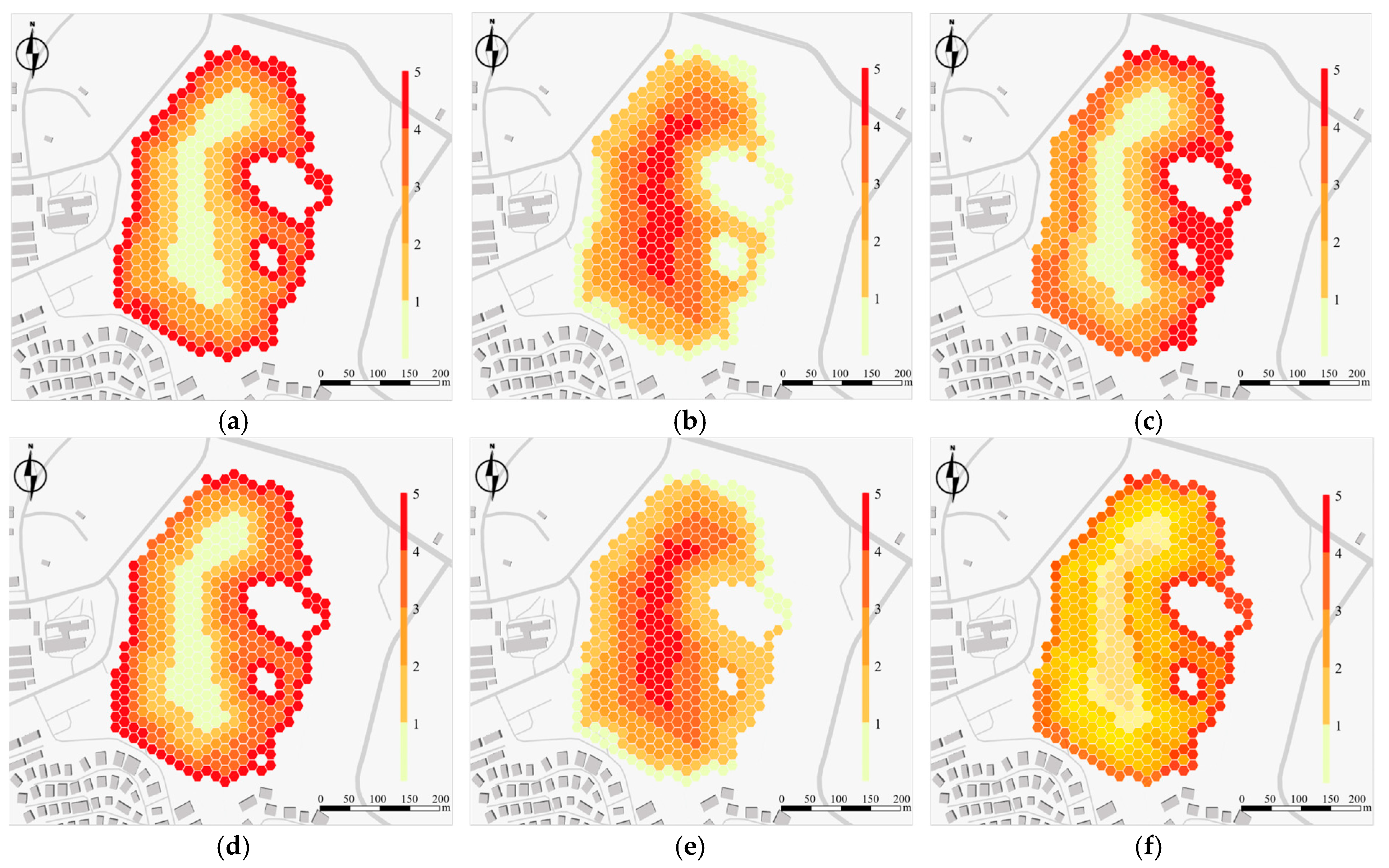
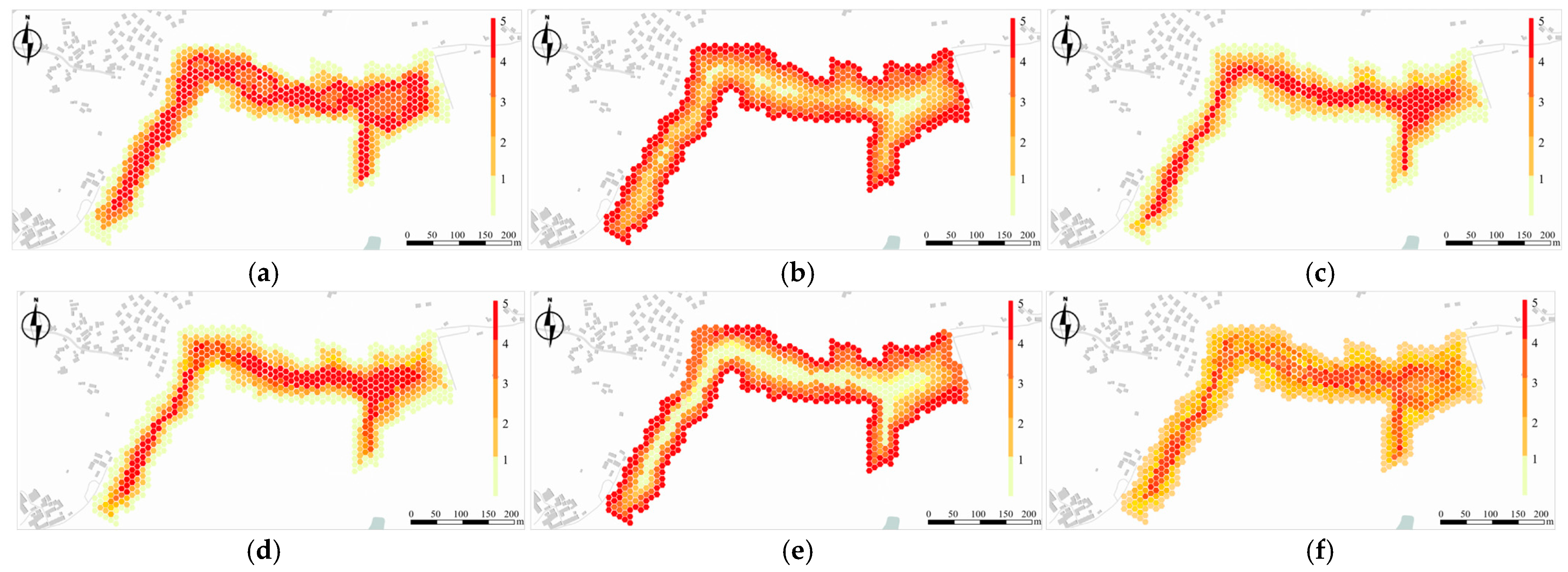
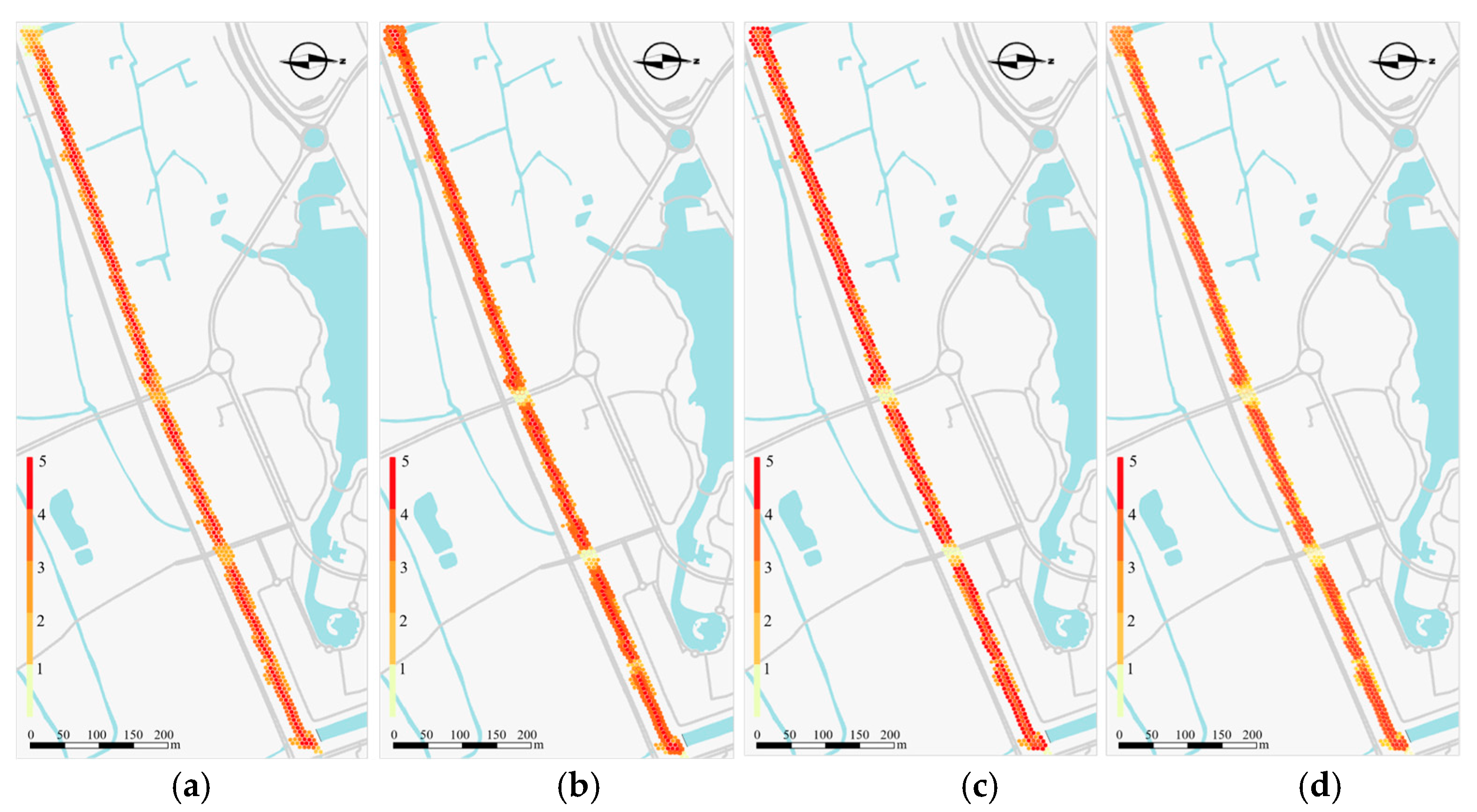
The preferences of various types of water sports participants for urban water landscapes exhibit clear differentiation, fundamentally driven by differences in sports goals and physical and mental demands. Based on scoring results, each site is evaluated using scoring and grading assessments. The assessment covers the active areas within the water, with SDU delineated as the basic analysis unit. The subjective score of each spatial unit is visualized through color saturation. The scoring level ranges from 1 to 5, corresponding to color saturation from low to high, and reflecting the distribution of urban water landscape preferences among various types of water sports participants. The gray area in the picture represents the surrounding environment of each lake.
In Jiulong Lake, the areas with high suitability scores are primarily concentrated along the shoreline and in shallow waters. These areas, featuring clear water, rich surrounding greening, and calm surfaces, provide amateurs with safe, comfortable, and sensory-pleasing urban water landscapes (Figure 5).
In Bailu Lake, the areas with high suitability scores are primarily concentrated in those with moderate water depths and unobstructed surfaces. The length of the paddling path meets training requirements. The circumstance environment is natural, with rich visual variations and sparse shrub isolation belts, providing progressors with urban water landscapes that are highly functional and conducive to concentration (Figure 6).
In the southern section of Shendi Ring River, the areas with high suitability scores are primarily concentrated along extra-long channels with deep water. These areas feature controllable wind speed, dry and cool climate, broad visibility, and unobstructed surfaces, providing professionals with urban water landscapes that are characterized by strong professional quality and outstanding functions (Figure 7).

3.3. Correlation Between Subjective Perception of Water Landscape Images by Various Types of Water Sports Participants and Objective Evidence of Urban Water Landscape Elements

3.3.1. Amateurs

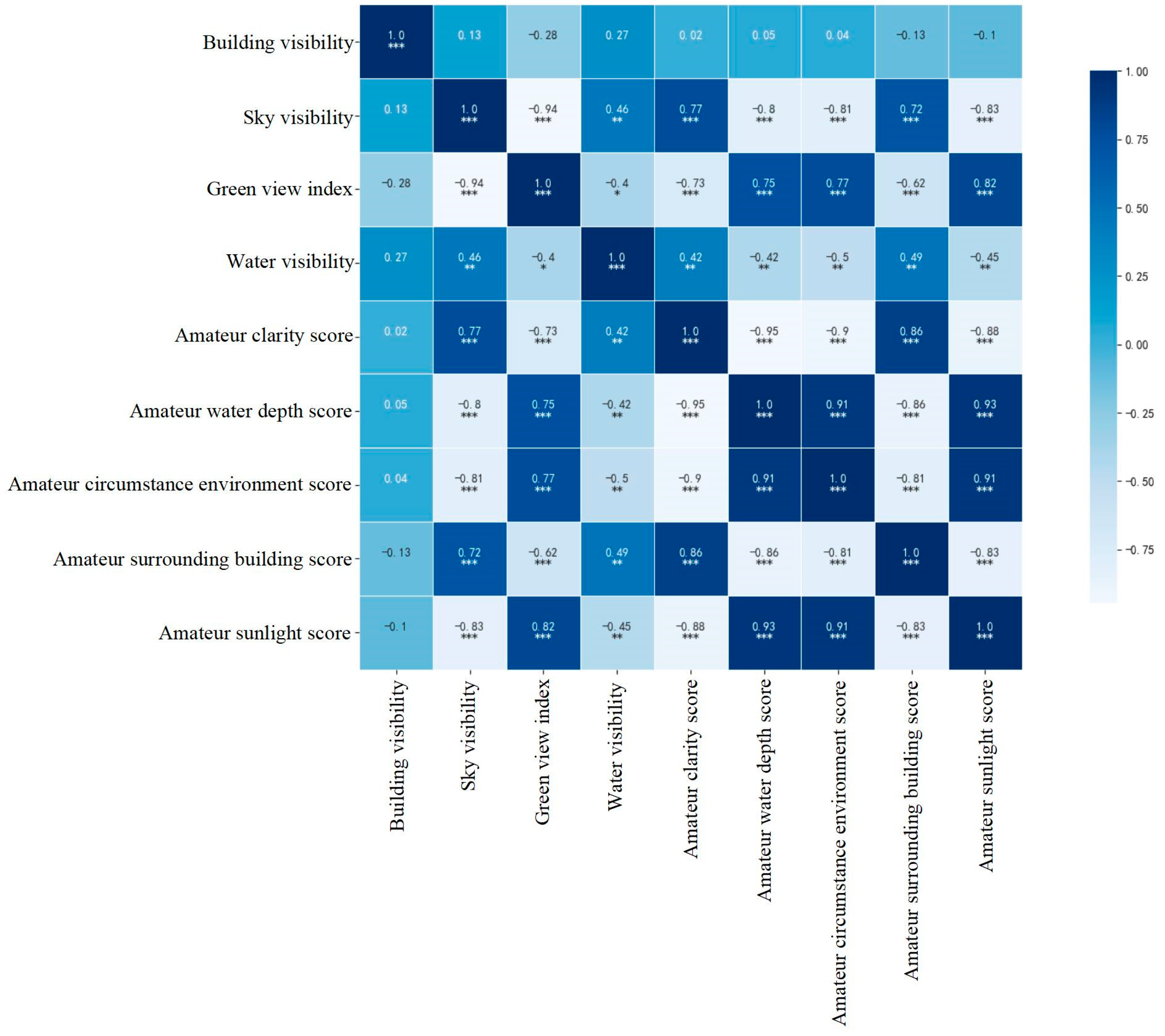
Amateurs prioritize comfort and safety as their core requirements (Appendix A, Table A1). The green view index is significantly positively correlated with amateurs’ scoring of circumstance environment (r = 0.77, p < 0.001), indicating that highly green environments play an important role in relieving stress and enhancing pleasure. Water visibility is negatively correlated with amateurs’ scoring of water depth (r = −0.42, p < 0.01), reflecting their sensitivity to water safety. Sky visibility is negatively correlated with amateurs’ scoring of sunlight comfort (r = −0.83, p < 0.001), suggesting that shaded environments better meet their preferences for hypothermal comfort (Figure 8).
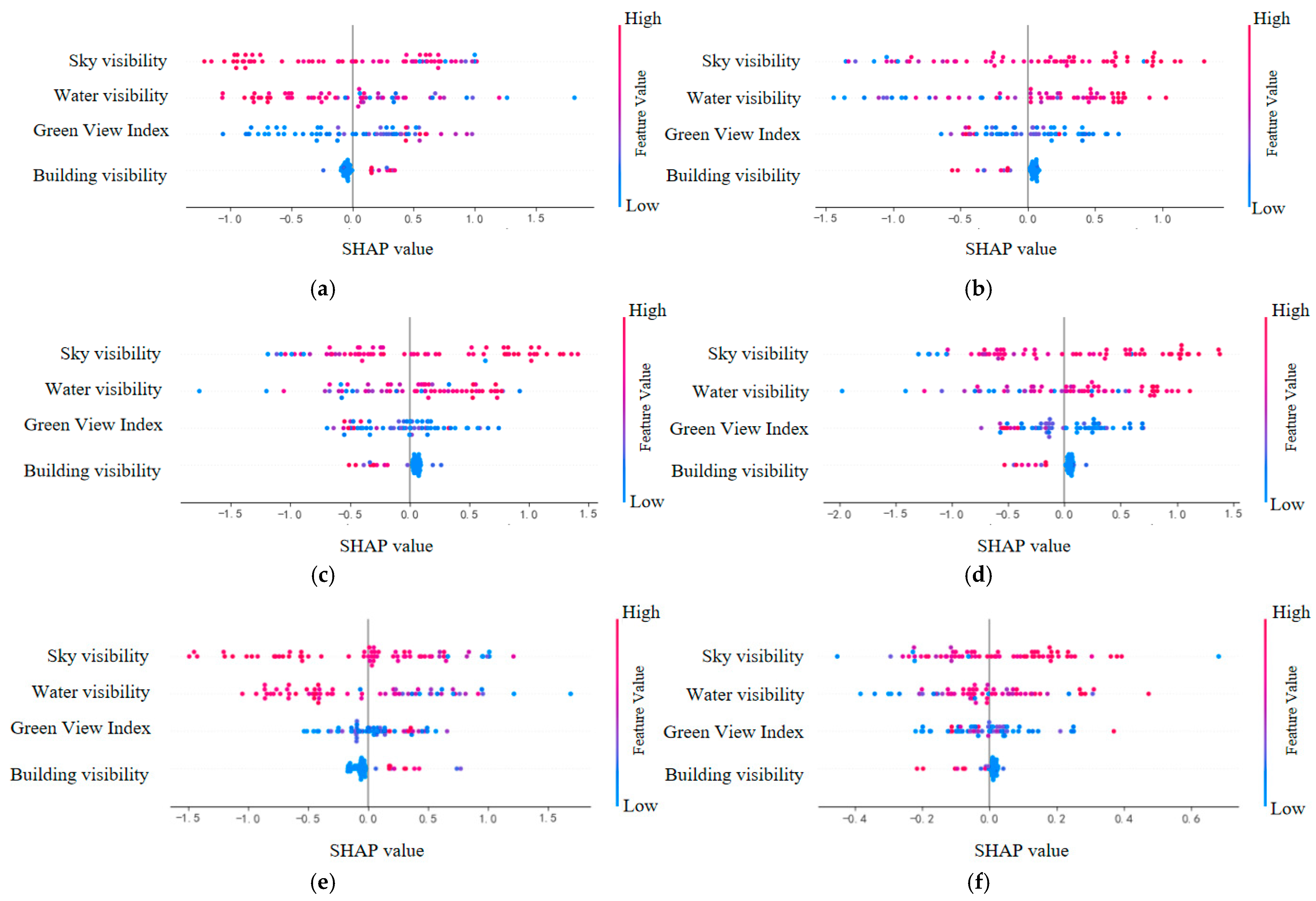
SHAP analysis results indicate that among the objective evidence that affects the subjective comprehensive score of amateurs, the green view index shows the strongest explanatory power, and its importance is significantly higher than that of other factors. The specific ranking is green visibility > water visibility > sky visibility > building visibility. SHAP analysis further validates the dominant role of the green view index in the subjective perception of amateurs. Integration of natural landscapes enhances the relaxation effect of water landscapes, while clear water provides additional visual comfort. Water visibility helps create a safe and tranquil sports environment by alleviating the anxiety about water depth. The ideal water sports space should focus on safety, comfort, and natural beauty, providing a relaxing and pleasant sports experience (Figure 9).

3.3.2. Progressors

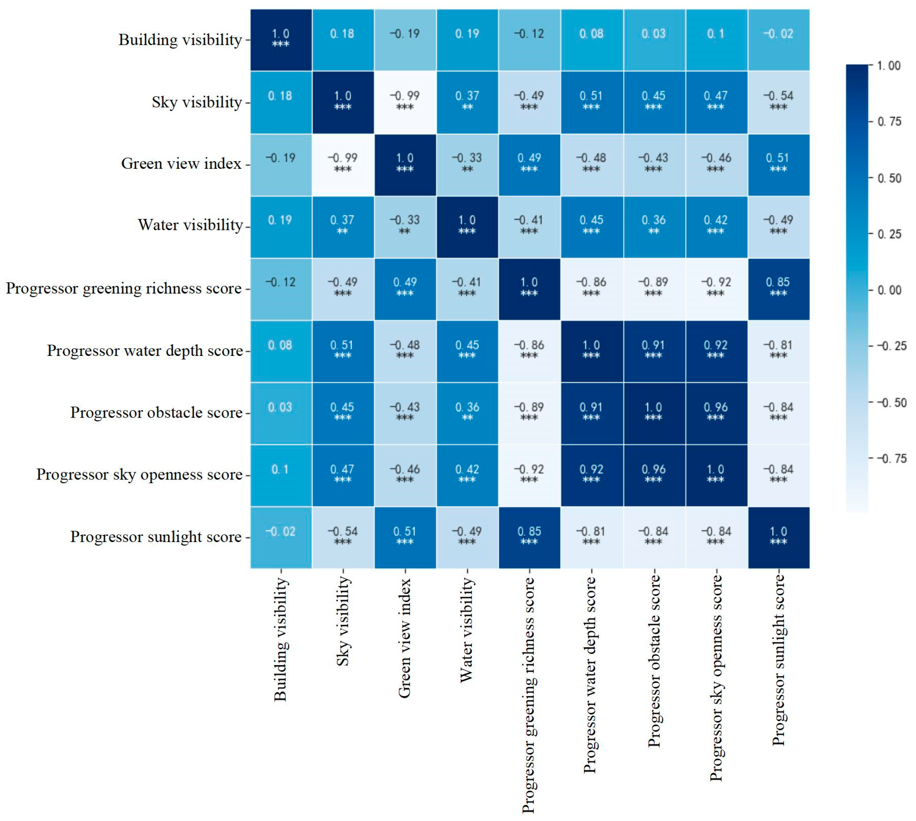
Progressors pay more attention to functional adaptation and training efficiency (Appendix A, Table A2). Sky visibility is positively correlated with progressors’ scoring of sky openness (r = 0.47, p < 0.001), indicating that broad visibility is conductive to spatial judgment and operational stability during complex movements. Water visibility is positively correlated with progressors’ scoring of water depth (r = 0.45, p < 0.01), suggesting that a wide water body facilitates precise spatial control. The green view index is positively correlated with progressors’ scoring of greening richness (r = 0.49, p < 0.001), indicating that moderate greening enhances the training atmosphere and helps maintain concentration (Figure 10).
SHAP analysis results indicate that among the objective evidence that affects the subjective comprehensive score of progressors, sky visibility and water visibility show the strongest explanatory power, and their importance is significantly higher than that of other factors. The specific ranking is sky visibility > water visibility > green visibility > building visibility. SHAP analysis further shows that sky visibility and water visibility are the key factors influencing progressors’ subjective perception. Open sky helps reduce visual interference and improve concentration and training efficiency, while clear water strengthens spatial control over the water. These urban water landscapes collectively provide progressors with ideal training spaces that are both challenging and safe. Therefore, moderate water visibility and good sky openness are the core requirements of progressors for urban water landscapes (Figure 11).

3.3.3. Professionals

Professionals exhibit the highest requirements for environmental professionalism (Appendix A, Table A3). Sky visibility is significantly positively correlated with professionals’ scoring of sky openness (r = 0.84, p < 0.001), indicating that broad visibility plays a key role in high-intensity training and decision-making efficiency. Water visibility is positively correlated with professionals’ scoring of water depth (r = 0.72, p < 0.001) and scoring of surface openness (r = 0.53, p < 0.001), highlighting the supportive effect of clear and broad water bodies on competitive performance. Bridge visibility is negatively correlated with professionals’ scoring of visual openness (r = −0.62, p < 0.001), suggesting that visual obstructions interfere with attention and performance (Figure 12).
SHAP analysis results indicate that among the objective evidence that affects the subjective comprehensive score of professionals, bridge visibility shows the strongest explanatory power, and its importance is significantly higher than that of other factors. The specific ranking is bridge visibility > sky visibility > green visibility > building visibility > water visibility. SHAP analysis indicates that sky visibility remains the most important factor influencing professionals’ subjective perception. Open sky not only optimizes training and competition experiences but also helps professionals maintain stable and excellent performance under high-intensity conditions. Meanwhile, water visibility is equally critical. Clear and broad water surfaces facilitate precise judgment of water conditions, improving operational efficiency and safety. Across the southern section of Shendi Ring River, water visibility is balanced, providing an overall environment for professional training. However, visual obstacles such as bridges have been confirmed to interfere with professionals’ concentration and negatively affect competitive performance. Therefore, they should be avoided in water landscape design. For professionals, an ideal urban water landscape should feature broad visibility, a clear water surface, and minimal visual interference so as to meet their core requirements for high-quality training and competition conditions (Figure 13).

4. Discussion

4.1. Differentiated Urban Water Landscapes for Three Types of Water Sports Participants

Based on the above contents, differentiated urban water landscapes are constructed to meet the requirements of various types of water sports participants.

4.1.1. Urban Water Landscape Design for Amateurs: High-Combination Richness Scenarios Centering on Comfort and Psychological Safety

Amateurs aim to relax, engage in low-intensity sports, and get close to the nature, requiring high environmental comfort and psychological safety. An ideal urban water landscape should present a high-combination richness space characteristic, i.e., high green-view index (>20%) + low water visibility (≤30%) + low sky visibility (≤30%) + shallow-water areas (≤1.5 m). This combination helps reduce psychological stress, enhance a sense of safety, and provide visual relaxation through greening richness and sparse buildings. Shallow water areas increase activity comfort. Ecologically guided landscape design creates low-interference and low-anxiety environments, offering amateurs ideal spaces for emotional restoration and sensory pleasure.

4.1.2. Urban Water Landscape Design for Progressors: Function–Scale Balanced Neutral Environment

Progressors pursue skill improvement and challenges, requiring a balance between functionality and adjustability in the environment. An ideal urban water landscape exhibits a neutral spatial combination: moderate green-view index (10–20%) + moderate water visibility (30–40%) + moderate sky visibility (30–40%) + medium water-depth (1.5–2.5 m). This combination balances visual transparency and spatial enclosure, providing appropriate external stimuli and direction perception and maintaining some natural enclosure and psychological buffering spaces. Medium water depth offers the necessary physical load and technical feedback for training, facilitating movement standardization and stability. Moderate greening creates a sense of rhythm and pause through local shading and landscape variations, helping regulate sport rhythms and recovery. Such urban water landscapes emphasize scale and experience coordination, assisting progressors in accumulating skills and improving physical adaptation in a stable environment.

4.1.3. Urban Water Landscape Design for Professionals, i.e., High-Performance Water Spaces Centering on Competitive Speed

Professionals focus on speed, explosive power, and technical limits as core objectives, having clear professional requirements for urban water landscapes. An ideal competitive urban water landscape should provide clear direction, minimal environmental interference, and high visibility to support high-intensity and high-concentration sports. Its space features low-combination richness: high water visibility (>40%) + high sky visibility (>40%) + low green-view index (<10%) + deep-water area (>2.5 m). This combination creates a broad, bright, and strong dynamic visual environment, facilitating rapid judgment of water surface conditions and spatial direction and improving response efficiency and sports performance. Deep water reduces water backflow resistance, providing stable support for high-speed waterskiing. Low greening minimizes visual interference and enhances concentration. High sky visibility and water reflection form a concise visual interface, reinforcing strong spatial directionality. Such landscape space based on speed performance emphasizes efficiency, stability, and concentration, constructing a professional, low-interference, and highly responsive water platform for professionals.

4.2. Comparison of Differences Among Urban Water Landscapes

A comparative study on Jiulong Lake, Bailu Lake, and the southern section of Shendi Ring River illustrates the influence of different urban water landscapes on the subjective perception of various types of water sports participants. The open water surface and rich greening of Jiulong Lake provide a suitable environment for amateurs engaging in low-intensity and relaxing sports. Bailu Lake, with moderate water depth and water visibility, offers challenge and safety and is suitable for progressors’ skill training. The southern section of Shendi Ring River features high water and sky visibility and deep water, minimizing visual interference, facilitating professionals’ high-intensity training, and enhancing concentration and performance. Different urban water landscape designs can meet the requirements of various types of water sports participants. Therefore, urban water landscape planning should consider these differences, optimize urban water landscapes, and improve sports experiences.

4.3. Application of Subjective Perception and Objective Evidence in Urban Water Landscape Planning

The integration of subjective perception and objective evidence data provides a new perspective and scientific basis for urban water landscape planning and design. This approach overcomes the limitations of traditional subjective perception, comprehensively evaluating the quality and functions of urban water landscapes. In practical applications, it helps planners and designers better understand the requirements of various types of water sports participants and design urban water landscapes that are attractive and functional.

4.4. Provision of a Quantitative Basis for the Policy of Hierarchical Leisure Zoning

This study provides a scientific basis for the precise zoning and management of urban water spaces by accurately quantifying the preferences of various types of water sports participants. The research results indicate that a unified planning standard is insufficient to meet the diverse needs of users. Therefore, urban planning practices can use the specific thresholds determined in this study to divide different functional areas and develop differentiated management guidelines. This evidence-based approach can optimize the allocation of limited waterfront resources. It guides the design of community parks towards the safety and comfort of recreational users, while also guiding regional water sports centers to meet the high-performance needs of training and competition. Ultimately, this stratification improves the efficiency of public space utilization and enhances user satisfaction by ensuring that each area is suitable for its primary user group.

5. Limitations

(1)
Geographical limitations: The study focuses on inland lakes and channel water bodies, without considering the unique environmental characteristics of coastal water bodies. Factors such as tidal variation, wind speed, and waves may affect participants’ experiences and requirements. Future studies should include coastal water bodies and compare inland and coastal water bodies to enrich urban water landscape planning and design.
(2)
Subjective perception data limitations: Subjective perception data rely primarily on questionnaires and volunteer scores, which are affected by participants’ emotions, preferences, and environmental conditions on the day of survey and display a degree of subjectivity and inconsistency. Future studies should consider diverse data collection methods, such as long-term behavior observation and physiological monitoring, and expand the sample range to cover participants of different ages, genders, and cultural backgrounds.
(3)
Urban water landscape elements limitations: Although this study has analyzed core landscape elements such as water visibility, green view index, and sky visibility, other factors such as water quality, noise pollution, nighttime lighting, and seasonal variation may significantly influence water sports experiences. Future research can take into account a wider range of physical, chemical, and biological indicators so as to provide a more comprehensive assessment.

6. Conclusions

This paper combines subjective perception with objective evidence to explore the preferred sports scenarios for various types of water sports participants and optimize the key elements of urban water landscapes. The findings indicate that amateurs prefer urban water landscapes with rich greening, broad visibility, and shallow water areas; progressors favor urban water landscapes with moderate water depth and minimal obstacles; and professionals require urban water landscapes with broad visibility, clear water, and deep water areas. Semantic segmentation was employed to quantify urban water landscapes, and Spearman correlation analysis was combined with the SHAP-XGBoost model to explore the correlation between the subjective perception of water landscape images by various types of water sports participants and the objective evidence of urban water landscape elements. This approach not only reveals differences in participants’ preferences for urban water landscapes but also provides a concrete reference for optimizing urban water landscapes.
Based on quantitative analysis results, this study can provide differentiated design strategies for future urban water landscape planning and management. To achieve sustainable optimization of urban water landscapes, a closed-loop mechanism of dynamic management and intelligent feedback needs to be established. The dynamic management strategy emphasizes adaptive design through the seasonal pruning of vegetation, planting deciduous trees in professional areas, adjusting sky visibility through natural changes in winter and summer, and flexibly regulating water levels. Meanwhile, the integration of intelligent perception systems will enhance management accuracy by deploying sensor networks to monitor objective indicators such as water depth and clarity in real-time and combining digital feedback platforms to collect subjective user experience data, jointly building a data-driven closed-loop of “monitoring evaluation optimization”. This collaborative mechanism provides a scientific basis for the refined management of water landscapes, helping to create functional and sustainable urban water sports spaces.

Supplementary Materials

The following supporting information can be downloaded at: https://www.mdpi.com/article/10.3390/w17223292/s1.

Author Contributions

Conceptualization, N.W.; methodology, W.W. and L.D.; software, W.W. and C.Z.; validation, C.Z.; formal analysis, W.W. and C.Z.; investigation, W.W., C.Z., and D.P.; resources, W.W. and L.D.; data curation, L.D. and C.Z.; writing—original draft preparation, C.Z.; writing—review and editing, N.W., W.W., and L.D.; visualization, W.W. and C.Z.; supervision, N.W. and L.D.; project administration, N.W.; funding acquisition, N.W. All authors have read and agreed to the published version of the manuscript.

Funding

This research was funded by the General Project of Philosophy and Social Science Research in Colleges and Universities in Jiangsu Province, “Pathway and Assessment of How Urban Waterbody Improves Water sports Wellness” [grant unit: Jiangsu Provincial Department of Education. grant number: 2025SJYB0166].

Institutional Review Board Statement

Ethical review and approval were waived for this study due to Articles 3 and 5 of the Interim Measures for Science and Technology Ethics Review of Nanjing Tech University (Nan Gong Xiao Ke [2023] No. 13), which stipulate that non-biomedical research involving only anonymous surveys without sensitive data collection or intervention is exempt from formal ethics review.

Informed Consent Statement

The study posed no risk to participants and involved no deception, coercion, or compensation. Participation was completely voluntary, and participants could withdraw at any time. All data were anonymized and used solely for academic research.

Data Availability Statement

The original contributions presented in this study are included in the article/Supplementary Material. Further inquiries can be directed to the corresponding author.

Conflicts of Interest

Author Ling Dai was employed by Shanghai Hongyang Landscape Greening Engineering Co., Ltd., and Weixuan Wei was employed by Future City (Shanghai) Design Consulting Co., Ltd. The remaining authors declare no commercial or financial relationships that could be construed as potential conflicts of interest.

Appendix A

Table A1. Summary of Spearman correlation r-values and p-values for amateurs.
Clarity ScoreWater Depth ScoreCircumstance Environment ScoreSurrounding Building ScoreSunlight Score
Building visibility0.020.050.04−0.13−0.1
Sky visibility0.77 ***−0.8 ***−0.81 ***0.72 ***−0.83 ***
Green View visibility−0.73 ***0.75 ***0.77 ***−0.62 ***0.82 ***
Water visibility0.42 **−0.42 **−0.5 **0.49 **−0.45 **
Note: ** p < 0.05; *** p < 0.01.
Table A2. Summary of Spearman correlation r-values and p-values for progressors.
Greening Richness ScoreWater Depth ScoreObstacle ScoreSky Openness ScoreSunlight Score
Building visibility−0.120.080.030.1−0.02
Sky visibility−0.49 ***0.51 ***0.45 ***0.47 ***−0.54 ***
Green View visibility0.49 ***−0.48 ***−0.43 ***−0.46 ***0.51 ***
Water visibility−0.41 **0.45 **0.36 **0.42 **−0.49 **
Note: ** p < 0.05; *** p < 0.01.
Table A3. Summary of Spearman correlation r-values and p-values for professionals.
Clarity ScoreWater Depth ScoreCircumstance Environment ScoreSurrounding Building ScoreSunlight Score
Building visibility0.020.050.04−0.13−0.1
Sky visibility0.77 ***−0.8 ***−0.81 ***0.72 ***−0.83 ***
Green View visibility−0.73 ***0.75 ***0.77 ***−0.62 ***0.82 ***
Water visibility0.42 **−0.42 **−0.5 **0.49 **−0.45 **
Note: ** p < 0.05; *** p < 0.01.

References

  1. T/CGDF 00009-2020; Guidelines for Ecological Civilization Construction. Standards Press of China: Beijing, China, 2020.
  2. GB/T 51346-2019; Urban Green Space Planning Standard. China Architecture and Building Press: Beijing, China, 2019.
  3. GB 51192-2016; Park Design Code. China Architecture and Building Press: Beijing, China, 2016.
  4. Maller, C.; Townsend, M.; Pryor, A.; Brown, P.; Leger, L.S. Healthy nature healthy people: ‘Contact with nature’ as an upstream health promotion intervention for populations. Health Promot. Int. 2006, 21, 45–54. [Google Scholar] [CrossRef]
  5. Thompson Coon, J.; Boddy, K.; Stein, K.; Whear, R.; Barton, J.; Depledge, M.H. Does participating in physical activity in outdoor natural environments have a greater effect on physical and mental wellbeing than physical activity indoors? A systematic review. Environ. Sci. Technol. 2011, 45, 1761–1772. [Google Scholar] [CrossRef]
  6. Eigenschenk, B.; Thomann, A.; McClure, M.; Davies, L.; Gregory, M.; Dettweiler, U.; Ingles, E. Benefits of outdoor sports for society. A systematic literature review and reflections on evidence. Int. J. Environ. Res. Public Health 2019, 16, 937. [Google Scholar] [CrossRef]
  7. Thompson, N.; Wilkie, S. ‘I’m just lost in the world’: The impact of blue exercise on participant well-being. Qual. Res. Sport Exerc. Health 2021, 13, 624–638. [Google Scholar] [CrossRef]
  8. Foley, R.; Kistemann, T. Blue space geographies: Enabling health in place. Health Place 2015, 35, 157–165. [Google Scholar] [CrossRef] [PubMed]
  9. Britton, E.; Kindermann, G.; Domegan, C.; Carlin, C. Blue care: A systematic review of blue space interventions for health and wellbeing. Health Promot. Int. 2020, 35, 50–69. [Google Scholar] [CrossRef]
  10. Gascon, M.; Zijlema, W.; Vert, C.; White, M.; Nieuwenhuijsen, M. Outdoor blue spaces, human health and well-being: A systematic review of quantitative studies. Int. J. Hyg. Environ. Health 2017, 220, 1207–1221. [Google Scholar] [CrossRef] [PubMed]
  11. Grellier, J.; White, M.P.; Albin, M. BlueHealth: A study programme protocol for map and quantifying the potential benefits to public health and well-being from Europe’s blue spaces. BMJ Open 2017, 7, e016188. [Google Scholar] [CrossRef] [PubMed]
  12. Schram, B.; Hing, W.; Climstein, M. Profiling the sport of stand-up paddle boarding. J. Sports Sci. 2015, 34, 937–944. [Google Scholar] [CrossRef]
  13. Bell, S.L.; Phoenix, C.; Lovell, R.; Wheeler, B. Seeking everyday wellbeing: The coast as a therapeutic landscape. Soc. Sci. Med. 2015, 142, 56–67. [Google Scholar] [CrossRef]
  14. White, M.P.; Pahl, S.; Ashbullby, K.; Herbert, S.; Depledge, M.H. Feelings of restoration from recent nature visits. J. Environ. Psychol. 2013, 35, 40–51. [Google Scholar] [CrossRef]
  15. Meloni, M.; Natale, D.; Caria, A. Land-and water-based sports activities in natural environments as a group exercise for Parkinson’s disease: Proof-of-concept pilot study. Sport Sci. Health 2025, 21, 839–851. [Google Scholar] [CrossRef]
  16. Brittain, E.L.; Han, L.; Annis, J.; Master, H.; Hughes, A.; Roden, D.M.; Harris, P.A.; Ruderfer, D.M. Physical Activity and Incident Obesity Across the Spectrum of Genetic Risk for Obesity. JAMA Netw. Open 2024, 7, e243821. [Google Scholar] [CrossRef]
  17. Mitchell, R.; Popham, F. Greenspace, urbanity and health: Relationships in England. Epidemiol. Community Health 2007, 61, 681–683. [Google Scholar] [CrossRef]
  18. Frumkin, H.; Bratman, G.N.; Breslow, S.J.; Cochran, B.; Kahn, P.H., Jr.; Lawler, J.J.; Levin, P.S.; Tandon, P.S.; Varanasi, U.; Wolf, K.L.; et al. Nature Contact and Human Health: A Research Agenda. Environ. Health Perspect. 2017, 125, 075001. [Google Scholar] [CrossRef]
  19. Liu, B.Y. The Trialism and Application of Human Settlement, Inhabitation and Travel Environment Studies: Applications in Water-Net Region; Springer: Berlin/Heidelberg, Germany, 2023; Volume 1, pp. 1–29. [Google Scholar]
  20. Liu, B.Y. On the Trialism of Landscape Architecture. Chin. Landsc. Archit. 2013, 29, 37–45. [Google Scholar]
  21. Liu, B.Y. Exploration of the Aesthetic of Landscape Architecture: Mechanism of Perception and Interaction between Human and Environment of “Jing” and the Principles of “Jing” Environment Circuit Design. Chin. Landsc. Archit. 2024, 40, 6–14. [Google Scholar]
  22. Hasegawa, Y.; Lau, S.K. Comprehensive audio-visual environmental effects on residential soundscapes and satisfaction: Partial least square structural equation modeling approach. Landsc. Urban Plan. 2022, 220, 104351. [Google Scholar] [CrossRef]
  23. Kürkçüoğlu, E.; Oya, A. The effects of water elements in urban space perception: A case study in Üsküdar Municipality Square. A|Z ITU J. Fac. Archit. 2013, 10, 159–175. [Google Scholar]
  24. Larkin, A.; Hystad, P. Evaluating street view exposure measures of visible green space for health research. J. Expo. Sci. Environ. Epidemiol. 2019, 29, 447–456. [Google Scholar] [CrossRef]
  25. Liu, Z.; Ma, X.; Hu, L. Information in Streetscapes: Research on Visual Perception Information Quantity of Street Space Based on Information Entropy and Machine Learning. ISPRS Int. J. Geo-Inf. 2022, 11, 628. [Google Scholar] [CrossRef]
  26. Tang, J.; Long, Y. Measuring visual quality of street space and its temporal variation: Methodology and its application in the Hutong area in Beijing. Landsc. Urban Plan. 2019, 191, 103436. [Google Scholar] [CrossRef]
  27. Cai, Y.J.; Zhou, P.; Zhang, B.J.; Shao, B. The Relationship between Perception of Public Sports Space and Sports Activity Behavior of Urban Residents. J. Chengdu Sport Univ. 2018, 44, 48–53. [Google Scholar] [CrossRef]
  28. Deelen, I.; Janssen, M.; Vos, S. Attractive running environments for all? A cross-sectional study on physical environmental characteristics and runners’ motives and attitudes, in relation to the experience of the running environment. BMC Public Health 2019, 19, 366. [Google Scholar] [CrossRef]
  29. Zhang, S.; Liu, N.; Ma, B.; Yan, S.R. The effects of street environment features on road running: An analysis using crowdsourced fitness tracker data and machine learning. Environ. Plan. B Urban Anal. City Sci. 2024, 51, 529–545. [Google Scholar] [CrossRef]
  30. Huang, D.; Jiang, B.; Yuan, L. Analyzing the effects of nature exposure on perceived satisfaction with running routes: An activity path-based measure approach. Urban For. Urban Green. 2022, 68, 127480. [Google Scholar] [CrossRef]
  31. Schipperijn, J.; Bentsen, P.; Troelsen, J.; Toftager, M.; Stigsdotter, U.K. Associations between physical activity and characteristics of urban green space. Urban For. Urban Green. 2013, 12, 109–116. [Google Scholar] [CrossRef]
  32. Wang, N.; Wei, W.X.; Liu, B.Y. Walking and jogging physical activity efficiency Oriented Park trail design: A case study of Park Trail in NanJing Fishmouth Wetland Park. China Landsc. Architect. 2021, 2, 48–53. [Google Scholar]
  33. Wang, N.; Wei, W.X.; Qian, Y.H.; Gao, H.; Qiu, H. Assessing the correlation between park view elements and exercise physiological indicators of walkers, joggers, and runners: A case study of Century Park in Shanghai. Front. Public Health 2024, 12, 1499197. [Google Scholar] [CrossRef]
  34. Wang, N.; Wang, Q.R.; Wei, W.X.; Liu, G.P.; Liu, M. Landscape Scene Sequences of Park View Elements Facilitate Walking, Jogging, and Running: Evidence from 3 Parks in Shanghai. Buildings 2025, 15, 1518. [Google Scholar] [CrossRef]
  35. Gilburn, A.S. Exercise should be blue and green: Seasonal variation in how woodland and freshwater interact to enhance participation in active leisure events. Urban For. Urban Green. 2025, 112, 128917. [Google Scholar] [CrossRef]
  36. Barbieri, C.; Sotomayor, S. Surf travel behavior and destination preferences: An application of the Serious Leisure Inventory and Measure. Tour. Manag. 2013, 35, 111–121. [Google Scholar] [CrossRef]
  37. Barlow, M.J.; Gresty, K.; Findlay, M.; Cooke, C.B.; Davidson, M.A. The effect of wave conditions and surfer ability on performance and the physiological response of recreational surfers. J. Strength Cond. Res. 2014, 28, 2946–2953. [Google Scholar] [CrossRef]
  38. Dolnicar, S.; Fluker, M. Behavioural market segments among surf tourists: Investigating past destination choice. J. Sport Tour. 2003, 8, 186–196. [Google Scholar] [CrossRef]
  39. Luo, J.; Zhao, T.; Cao, L.; Biljecki, F. Water View Imagery: Perception and evaluation of urban waterscapes worldwide. Ecol. Indic. 2022, 145, 109615. [Google Scholar] [CrossRef]
  40. Zhao, X.; Lin, G. Research on the Perception Evaluation of Urban Green Spaces Using Panoramic Images and Deep Learning: A Case Study of Zhujiang Park in Guangzhou. Landsc. Archit. Front. 2024, 12, 7–18. [Google Scholar]
  41. Sedlmair, M.; Aupetit, M. Data-driven evaluation of visual quality measures. Comput. Graph. Forum 2015, 34, 201–210. [Google Scholar] [CrossRef]
  42. Shou, Y.; Lei, Z.; Li, J.; Luo, J.J. Unveiling Urban River Visual Features Through Immersive Virtual Reality: Analyzing Youth Perceptions with UAV Panoramic Imagery. ISPRS Int. J. Geo-Inf. 2024, 13, 402. [Google Scholar] [CrossRef]
  43. Liu, X.; Deng, Z.; Yang, Y. Recent progress in semantic image segmentation. Artif. Intell. Rev. 2019, 52, 1089–1106. [Google Scholar] [CrossRef]
  44. Yue, Z.; Lo, C.Y.; Wu, R.; Ma, L.Y.; Sham, C.W. Urban aquatic scene expansion for semantic segmentation in cityscapes. Urban Sci. 2024, 8, 23. [Google Scholar] [CrossRef]
  45. Csurka, G.; Volpi, R.; Chidlovskii, B. Semantic image segmentation: Two decades of research. Found. Trends Comput. Graph. Vis. 2022, 14, 1–162. [Google Scholar] [CrossRef]
  46. Shirabe, T. A model of contiguity for spatial unit allocation. Geogr. Anal. 2005, 37, 2–16. [Google Scholar] [CrossRef]
  47. Steenbeek, W.; Weisburd, D. Where the action is in crime? An examination of variability of crime across different spatial units in The Hague, 2001–2009. J. Quant. Criminol. 2016, 32, 449–469. [Google Scholar] [CrossRef]
  48. Jafarzadehfadaki, M.; Sisiopiku, V.P. Embracing urban micromobility: A comparative study of e-scooter adoption in Washington, DC, Miami, and Los Angeles. Urban Sci. 2024, 8, 71. [Google Scholar] [CrossRef]
  49. Lee, J.-S.; Shin, D.-C. Prediction of Waste Generation Using Machine Learning: A Regional Study in Korea. Urban Sci. 2025, 9, 297. [Google Scholar] [CrossRef]
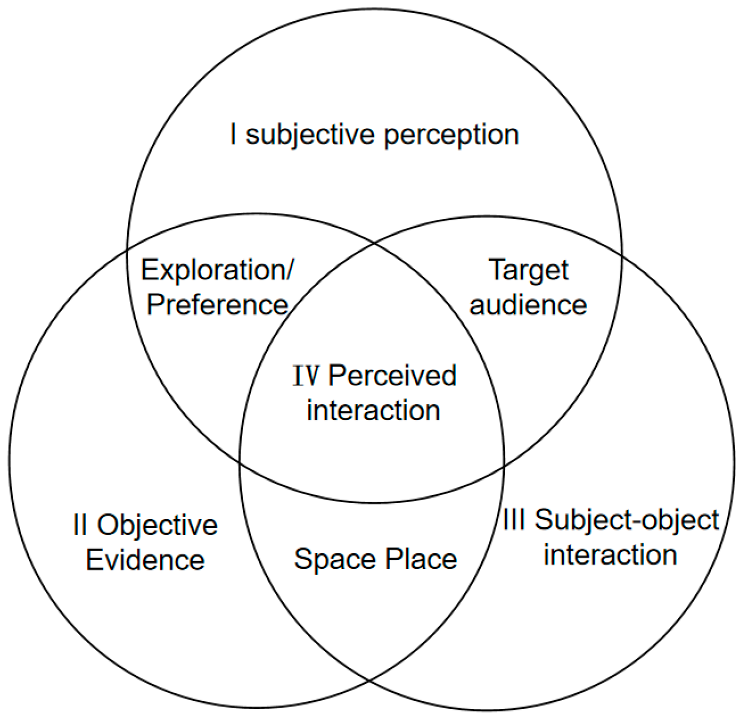
Figure 1. Research on strategic thinking—coupling interaction between subjective perception and objective evidence.
Water 17 03292 g001
Figure 2. Location map: (a) location of Jiulong Lake; (b) location of Bailu Lake; (c) location of the southern section of Shendi Ring River.
Water 17 03292 g002
Figure 3. Method and workflow.
Water 17 03292 g003
Figure 4. Semantic segmentation of water landscape images: (a) Jiulong Lake; (b) Bailu Lake; (c) the southern section of Shendi Ring River.
Water 17 03292 g004
Figure 5. Scores of water body elements at Jiulong Lake, Tangquan, Nanjing, from amateurs: (a) water depth; (b) clarity; (c) circumstance environment; (d) sunlight; (e) surrounding buildings; (f) comprehensive score.
Water 17 03292 g005
Figure 6. Scores of water body elements at Bailu Lake, Jiangning, Nanjing, from progressors: (a) water depth; (b) sunlight; (c) obstacles; (d) sky openness; (e) greening richness; (f) comprehensive score.
Water 17 03292 g006
Figure 7. Scores of water body elements at the southern section of Shendi Ring River, Shanghai from professionals: (a) water depth; (b) sky surface and visual openness; (c) circumstance environment; (d) comprehensive score.
Water 17 03292 g007
Figure 8. Matrix heat map of the correlation between subjective perception of water landscape images by amateurs and objective evidence of urban water landscape elements. Asterisks indicate statistically significant correlations, with p < 0.1, p < 0.05, and p < 0.01 denoted by *, **, and ***, respect.
Water 17 03292 g008
Figure 9. Explanation of XGBoost model based on SHAP for amateurs: (a) water depth; (b) clarity; (c) sunlight; (d) circumstance environment; (e) surrounding buildings; (f) comprehensive score.
Water 17 03292 g009
Figure 10. Matrix heat map of the correlation between subjective perception of water landscape images by progressors and objective evidence of urban water landscape elements. Asterisks indicate statistically significant correlations, with p < 0.1, p < 0.05, and p < 0.01 denoted by *, **, and ***, respect.
Water 17 03292 g010
Figure 11. Explanation of XGBoost model based on SHAP for progressors: (a) greening richness; (b) water depth; (c) obstacles; (d) sky openness; (e) sunlight; (f) comprehensive score.
Water 17 03292 g011
Figure 12. Matrix heat map of the correlation between subjective perception of water landscape images by professionals and objective evidence of urban water landscape elements. Asterisks indicate statistically significant correlations, with p < 0.1, p < 0.05, and p < 0.01 denoted by *, **, and ***, respect.
Water 17 03292 g012
Figure 13. Explanation of XGBoost model based on SHAP for professionals: (a) visual openness; (b) surface openness; (c) water depth; (d) sky openness; (e) circumstance environment; (f) comprehensive score.
Water 17 03292 g013
Table 1. Subjective perception scoring form.
Objective Evidence Indicators54321
Water depthVery deepDeepMedium deepShallowVery shallow
ClarityVery clearClearMedium clearSlightly turbidTurbid
Surface opennessVery spaciousSpaciousMedium spaciousNarrowVery narrow
SunlightVery coolCoolMedium coolHotVery hot
Greening richnessExcellentGoodGeneralPoorVery poor
ObstaclesNo obstacleFewer obstaclesGeneral obstaclesMultiple obstaclesSerious obstacles
Visual opennessExcellentGoodAveragePoorExtremely poor
Sky opennessExtremely openOpenGenerally openNarrowExtremely narrow
Circumstance environmentExcellentGoodOrdinaryPoorHarsh
Surrounding buildingsExtremely sparseSparseMedium denseDenseExtremely dense
Table 2. Construction of subjective perception and objective evidence indicator system.
Objective EvidenceSubjective Perception Indicators for AmateursSubjective Perception Indicators for ProgressorsSubjective Perception Indicators for ProfessionalsAde20k
Water visibilityWater depth, clarityWater depthWater depth, surface opennessWater
Green view indexCircumstance environmentGreening richnessCircumstance environmentGrass, tree
Building visibilitySurrounding buildingsObstacles Building
Sky visibilitySunlightSunlight, sky opennessSky opennessSky
Bridge visibility Visual opennessBridge
Disclaimer/Publisher’s Note: The statements, opinions and data contained in all publications are solely those of the individual author(s) and contributor(s) and not of MDPI and/or the editor(s). MDPI and/or the editor(s) disclaim responsibility for any injury to people or property resulting from any ideas, methods, instructions or products referred to in the content.