Combination of UAV Imagery and Deep Learning to Estimate Vegetation Height over Fluvial Sandbars
Abstract
1. Introduction
2. Materials and Methods
2.1. Study Area
2.2. UAV Data Collecting and Processing
2.2.1. UAV Information and Data Collection
2.2.2. Calculation of Vegetation Indexes (VIs) and Estimation of Vegetation Height
2.3. Model Architecture of FCNN
- Step 1
- Step 2
- Step 3
- Step 4
- Step 5
3. Results
3.1. Monitoring of Vegetation Height
3.2. Spatial Distribution of NDVI and GNDVI
3.3. Linear and Polynomial Regression Based Vegetation Height Prediction
3.4. Deep Learning-Based Vegetation Height Prediction
4. Discussion
5. Conclusions
Author Contributions
Funding
Data Availability Statement
Conflicts of Interest
References
- Sweeney, M.R.; Fischer, B.; Wermers, K.; Cowman, T. Eolian and Fluvial Modification of Missouri River Sandbars Deposited by the 2011 Flood, USA. Geomorphology 2019, 327, 111–125. [Google Scholar] [CrossRef]
- Stucker, J.H.; Buhl, D.A.; Sherfy, M.H. Emergent Sandbar Construction for Least Terns on the Missouri River: Effects on Forage Fishes in Shallow-Water Habitats. River Res. Appl. 2012, 28, 1254–1265. [Google Scholar] [CrossRef]
- Seki, S.; Moteki, D.; Yasuda, H. Novel Hypothesis on the Occurrence of Sandbars. Phys. Fluids 2023, 35, 106611. [Google Scholar] [CrossRef]
- Hu, Y.; Zhou, J.; Deng, J.; Li, Y.; Yang, C.; Li, D. River Bars and Vegetation Dynamics in Response to Upstream Damming: A Case Study of the Middle Yangtze River. Remote Sens. 2023, 15, 2324. [Google Scholar] [CrossRef]
- Heidari, N.; Yagci, O.; Aksel, M. Midchannel Islands in Lowland River Corridors and Their Impacts on Flow Structure and Morphology: A Numerical Based Conceptual Analysis. Ecol. Eng. 2021, 173, 106419. [Google Scholar] [CrossRef]
- Rood, S.B.; Goater, L.A.; Gill, K.M.; Braatne, J.H. Sand and Sandbar Willow: A Feedback Loop Amplifies Environmental Sensitivity at the Riparian Interface. Oecologia 2011, 165, 31–40. [Google Scholar] [CrossRef]
- Nagata, T.; Watanabe, Y.; Yasuda, H.; Ito, A. Development of a Meandering Channel Caused by the Planform Shape of the River Bank. Earth Surf. Dyn. 2014, 2, 255–270. [Google Scholar] [CrossRef]
- van Iersel, W.; Straatsma, M.; Addink, E.; Middelkoop, H. Monitoring Height and Greenness of Non-Woody Floodplain Vegetation with UAV Time Series. ISPRS J. Photogramm. Remote Sens. 2018, 141, 112–123. [Google Scholar] [CrossRef]
- Nones, M.; Di Silvio, G. Modeling of River Width Variations Based on Hydrological, Morphological, and Biological Dynamics. J. Hydraul. Eng. 2016, 142, 04016012. [Google Scholar] [CrossRef]
- Kiss, T.; Nagy, J.; Fehérváry, I.; Vaszkó, C. (Mis) Management of Floodplain Vegetation: The Effect of Invasive Species on Vegetation Roughness and Flood Levels. Sci. Total Environ. 2019, 686, 931–945. [Google Scholar] [CrossRef]
- De Doncker, L.; Troch, P.; Verhoeven, R.; Bal, K.; Meire, P.; Quintelier, J. Determination of the Manning Roughness Coefficient Influenced by Vegetation in the River Aa and Biebrza River. Environ. Fluid Mech. 2009, 9, 549–567. [Google Scholar] [CrossRef]
- Chen, Y.; Cao, F.; Cheng, W.; Liu, B.; Yu, P. Real-Time Correction of Channel-Bed Roughness and Water Level in River Network Hydrodynamic Modeling for Accurate Forecasting. Sci. Rep. 2023, 13, 20660. [Google Scholar] [CrossRef] [PubMed]
- Ferreira, D.M.; Fernandes, C.V.S.; Kaviski, E.; Bleninger, T. Calibration of River Hydrodynamic Models: Analysis from the Dynamic Component in Roughness Coefficients. J. Hydrol. 2021, 598, 126136. [Google Scholar] [CrossRef]
- Augustijn, D.C.M.; Huthoff, F.; Van Velzen, E.H. Comparison of Vegetation Roughness Descriptions. In Proceedings of the River Flow 2008: 4th International Conference on Fluvial Hydraulics, Izmir, Turkey, 3–5 September 2008; pp. 343–350. [Google Scholar]
- Latella, M.; Notti, D.; Baldo, M.; Giordan, D.; Camporeale, C. Short-Term Biogeomorphology of a Gravel-Bed River: Integrating Remote Sensing with Hydraulic Modelling and Field Analysis. Earth Surf. Process. Landforms 2024, 49, 1156–1178. [Google Scholar] [CrossRef]
- Kiss, T.; Fehérváry, I. Increased Riparian Vegetation Density and Its Effect on Flow Conditions. Sustainability 2023, 15, 12615. [Google Scholar] [CrossRef]
- Signorile, A.; Saracino, R.; Dani, A.; Rillo Migliorini Giovannini, M.; Preti, F. Riparian Vegetation Surveys for Roughness Estimation. Ecol. Eng. 2024, 209, 107414. [Google Scholar] [CrossRef]
- Wang, J.; Zhang, Z. Evaluating Riparian Vegetation Roughness Computation Methods Integrated within HEC-RAS. J. Hydraul. Eng. 2019, 145, 04019020. [Google Scholar] [CrossRef]
- Rillo Migliorini Giovannini, M.; Dani, A.; Saracino, R.; Signorile, A.; Preti, F. Hydraulic Roughness Estimation Induced by Riparian Vegetation in Tuscany Rivers for Management Purposes. Lect. Notes Civ. Eng. 2023, 337, 169–179. [Google Scholar] [CrossRef]
- Chen, S.; McDermid, G.J.; Castilla, G.; Linke, J. Measuring Vegetation Height in Linear Disturbances in the Boreal Forest with UAV Photogrammetry. Remote Sens. 2017, 9, 1257. [Google Scholar] [CrossRef]
- Chaulagain, S.; Stone, M.C.; Dombroski, D.; Gillihan, T.; Chen, L.; Zhang, S. An Investigation into Remote Sensing Techniques and Field Observations to Model Hydraulic Roughness from Riparian Vegetation. River Res. Appl. 2022, 38, 1730–1745. [Google Scholar] [CrossRef]
- Lu, J.; Cheng, D.; Geng, C.; Zhang, Z.; Xiang, Y.; Hu, T. Combining Plant Height, Canopy Coverage and Vegetation Index from UAV-Based RGB Images to Estimate Leaf Nitrogen Concentration of Summer Maize. Biosyst. Eng. 2021, 202, 42–54. [Google Scholar] [CrossRef]
- Gao, L.; Wang, X.; Johnson, B.A.; Tian, Q.; Wang, Y.; Verrelst, J.; Mu, X.; Gu, X. Remote Sensing Algorithms for Estimation of Fractional Vegetation Cover Using Pure Vegetation Index Values: A Review. ISPRS J. Photogramm. Remote Sens. 2020, 159, 364–377. [Google Scholar] [CrossRef] [PubMed]
- Zhang, J.; Qiu, X.; Wu, Y.; Zhu, Y.; Cao, Q.; Liu, X.; Cao, W. Combining Texture, Color, and Vegetation Indices from Fixed-Wing UAS Imagery to Estimate Wheat Growth Parameters Using Multivariate Regression Methods. Comput. Electron. Agric. 2021, 185, 106138. [Google Scholar] [CrossRef]
- Leroux, L.; Baron, C.; Zoungrana, B.; Traore, S.B.; Lo Seen, D.; Begue, A. Crop Monitoring Using Vegetation and Thermal Indices for Yield Estimates: Case Study of a Rainfed Cereal in Semi-Arid West Africa. IEEE J. Sel. Top. Appl. Earth Obs. Remote Sens. 2016, 9, 347–362. [Google Scholar] [CrossRef]
- Amani, S.; Shafizadeh-Moghadam, H. A Review of Machine Learning Models and Influential Factors for Estimating Evapotranspiration Using Remote Sensing and Ground-Based Data. Agric. Water Manag. 2023, 284, 108324. [Google Scholar] [CrossRef]
- Berzéki, M.; Kozma-Bognár, V.; Berke, J. Examination of Vegetation Indices Based on Multitemporal Drone Images; Gradus: Düsseldorf, Germany, 2023; Volume 10. [Google Scholar] [CrossRef]
- Sun, H.; Wang, X.; Fan, D.; Sun, O.J. Contrasting Vegetation Response to Climate Change between Two Monsoon Regions in Southwest China: The Roles of Climate Condition and Vegetation Height. Sci. Total Environ. 2022, 802, 149643. [Google Scholar] [CrossRef]
- Payero, J.O.; Neale, C.M.U.; Wright, J.L. Comparison of Eleven Vegetation Indices for Estimating Plant Height of Alfalfa and Grass. Appl. Eng. Agric. 2004, 20, 385–393. [Google Scholar] [CrossRef]
- Kalinowska, M.B.; Västilä, K.; Nones, M.; Kiczko, A.; Karamuz, E.; Brandyk, A.; Kozioł, A.; Krukowski, M. Influence of Vegetation Maintenance on Flow and Mixing: Case Study Comparing Fully Cut with High-Coverage Conditions. Hydrol. Earth Syst. Sci. 2023, 27, 953–968. [Google Scholar] [CrossRef]
- Boucher, P.B.; Hockridge, E.G.; Singh, J.; Davies, A.B. Flying High: Sampling Savanna Vegetation with UAV-Lidar. Methods Ecol. Evol. 2023, 14, 1668–1686. [Google Scholar] [CrossRef]
- Luo, S.; Liu, W.; Zhang, Y.; Wang, C.; Xi, X.; Nie, S.; Ma, D.; Lin, Y.; Zhou, G. Maize and Soybean Heights Estimation from Unmanned Aerial Vehicle (UAV) LiDAR Data. Comput. Electron. Agric. 2021, 182, 106005. [Google Scholar] [CrossRef]
- Prior, E.M.; Aquilina, C.A.; Czuba, J.A.; Pingel, T.J.; Hession, W.C. Estimating Floodplain Vegetative Roughness Using Drone-Based Laser Scanning and Structure from Motion Photogrammetry. Remote Sens. 2021, 13, 2616. [Google Scholar] [CrossRef]
- Nguyen, H.D.; Van, C.P.; Do, A.D. Application of Hybrid Model-Based Deep Learning and Swarm-based Optimizers for Flood Susceptibility Prediction in Binh Dinh Province, Vietnam. Earth Sci. Inform. 2023, 16, 1173–1193. [Google Scholar] [CrossRef]
- Gui, S.; Song, S.; Qin, R. Remote Sensing Object Detection in the Deep Learning Era—A Review. Remote Sens. 2024, 16, 327. [Google Scholar] [CrossRef]
- Wang, W.; Tang, J.; Zhang, N.; Xu, X.; Zhang, A.; Wang, Y.; Li, K.; Wang, Y. Vegetation Height Estimation Based on Machine Learning Model Driven by Multi-Source Data in Eurasian Temperate Grassland. Ecol. Indic. 2025, 170, 113013. [Google Scholar] [CrossRef]
- Luo, H.; Ou, G.; Yue, C.; Zhu, B.; Wu, Y.; Zhang, X.; Lu, C.; Tang, J. A Framework for Montane Forest Canopy Height Estimation via Integrating Deep Learning and Multi-Source Remote Sensing Data. Int. J. Appl. Earth Obs. Geoinf. 2025, 138, 104474. [Google Scholar] [CrossRef]
- Bhandari, K.; Srinet, R.; Nandy, S. Forest Height and Aboveground Biomass Mapping by Synergistic Use of GEDI and Sentinel Data Using Random Forest Algorithm in the Indian Himalayan Region. J. Indian Soc. Remote Sens. 2024, 52, 857–869. [Google Scholar] [CrossRef]
- Dersch, S.; Schöttl, A.; Krzystek, P.; Heurich, M. Semi-Supervised Multi-Class Tree Crown Delineation Using Aerial Multispectral Imagery and Lidar Data. ISPRS J. Photogramm. Remote Sens. 2024, 216, 154–167. [Google Scholar] [CrossRef]
- Yang, R.; Chen, M.; Lu, X.; He, Y.; Li, Y.; Xu, M.; Li, M.; Huang, W.; Liu, F. Integrating UAV Remote Sensing and Semi-Supervised Learning for Early-Stage Maize Seedling Monitoring and Geolocation. Plant Phenomics 2025, 7, 100011. [Google Scholar] [CrossRef]
- Nyamekye, C.; Appiah, L.B.; Arthur, R.; Osei, G.; Ofosu, S.A.; Kwofie, S.; Ghansah, B.; Bryniok, D. Comparing Supervised and Semi-Supervised Machine Learning Methods for Mapping Aquatic Weeds, as Biomass Resource from High-Resolution UAV Images. Remote Sens. Earth Syst. Sci. 2024, 7, 206–217. [Google Scholar] [CrossRef]
- Du, S.; Liu, H.; Xing, J.; Zhang, X.; Zhang, J.; Guan, X.; Du, S. Estimating Individual Building Heights by Integrating Spaceborne LiDAR and Multisource Remote Sensing Data: A CNN–Transformer Model and a Semi-Supervised Sample Augmentation Approach. IEEE Trans. Geosci. Remote Sens. 2025, 63, 5406719. [Google Scholar] [CrossRef]
- Jiang, Y.; Chen, X.F.; Yang, X.J. A Study on Changes of Aquatic Plants in East Lake of Wuhan Using 1990–2020 Landsat Images. Chin. J. Plant Ecol. 2022, 46, 1551–1561. [Google Scholar] [CrossRef]
- Wang, X.; Li, Z.; Ma, J.; Bai, K. Differential Scour of Two Mid-Channel Bars in Wuhan Reach of the Middle Yangtze River. J. Chang. River Sci. Res. Inst. 2024, 41, 18–27. [Google Scholar] [CrossRef]
- Fraser, B.T.; Robinov, L.; Davidson, W.; O’Connor, S.; Congalton, R.G. A Comparison of Unpiloted Aerial System Hardware and Software for Surveying Fine-Scale Oak Health in Oak–Pine Forests. Forests 2024, 15, 706. [Google Scholar] [CrossRef]
- Gutierrez-Rodriguez, M.; Escalante-Estrada, J.A.; Rodriguez-Gonzalez, M.T. Canopy Reflectance, Stomatal Conductance, and Yield of Phaseolus vulgaris L. and Phaseolus coccinues L. Under Saline Field Conditions. Int. J. Agric. Biol. 2005, 7, 491–494. [Google Scholar]
- Boothroyd, R.J.; Nones, M.; Guerrero, M. Deriving Planform Morphology and Vegetation Coverage from Remote Sensing to Support River Management Applications. Front. Environ. Sci. 2021, 9, 657354. [Google Scholar] [CrossRef]
- Rouse, J.W., Jr.; Haas, R.H.; Schell, J.A.; Deering, D.W. Monitoring Vegetation Systems in the Great Plains with ERTS. In Proceedings of the NASA Goddard Space Flight Center 3d ERTS-1 Symposium, Washington, DC, USA, 1 January 1974; Volume 1. Section A. [Google Scholar]
- Gitelson, A.A.; Kaufman, Y.J.; Merzlyak, M.N. Use of a Green Channel in Remote Sensing of Global Vegetation from EOS-MODIS. Remote Sens. Environ. 1996, 58, 289–298. [Google Scholar] [CrossRef]
- Barati, S.; Rayegani, B.; Saati, M.; Sharifi, A.; Nasri, M. Comparison the Accuracies of Different Spectral Indices for Estimation of Vegetation Cover Fraction in Sparse Vegetated Areas. Egypt. J. Remote Sens. Sp. Sci. 2011, 14, 49–56. [Google Scholar] [CrossRef]
- Allawai, M.F.; Ahmed, B.A. Using Remote Sensing and GIS in Measuring Vegetation Cover Change from Satellite Imagery in Mosul City, North of Iraq. IOP Conf. Ser. Mater. Sci. Eng. 2020, 757, 012062. [Google Scholar] [CrossRef]
- Karpiński, P.; Kocira, S.; Karpiński, P.; Kocira, S. Possibilities of Using a Multispectral Camera to Assess the Effects of Biostimulant Application in Soybean Cultivation. Sensors 2025, 25, 3464. [Google Scholar] [CrossRef]
- Bak, H.-J.; Kim, E.-J.; Lee, J.-H.; Chang, S.; Kwon, D.; Im, W.-J.; Kim, D.-H.; Lee, I.-H.; Lee, M.-J.; Hwang, W.-H.; et al. Canopy-Level Rice Yield and Yield Component Estimation Using NIR-Based Vegetation Indices. Agriculture 2025, 15, 594. [Google Scholar] [CrossRef]
- Steven, M.D. The Sensitivity of the OSAVI Vegetation Index to Observational Parameters. Remote Sens. Environ. 1998, 63, 49–60. [Google Scholar] [CrossRef]
- Rondeaux, G.; Steven, M.; Baret, F. Optimization of Soil-Adjusted Vegetation Indices. Remote Sens. Environ. 1996, 55, 95–107. [Google Scholar] [CrossRef]
- Popescu, S.C.; Zhao, K. A Voxel-Based Lidar Method for Estimating Crown Base Height for Deciduous and Pine Trees. Remote Sens. Environ. 2008, 112, 767–781. [Google Scholar] [CrossRef]
- DJI. DJI Terra-User Manual; v4.3; DJI: Shenzhen, China, 2024. [Google Scholar]
- Tan, C.; Chen, Z.; Liao, A.; Chen, Z.; Zeng, X. Accuracy Assessment of Mavic 3 Industrial UAV Based on DJI Terra and Pix4Dmapper. In Proceedings of the Fifth International Conference on Geology, Mapping, and Remote Sensing, Wuhan, China, 10 July 2024; SPIE: Bellingham, WA, USA; Volume 13223, pp. 498–504. [Google Scholar] [CrossRef]
- Carp, A. Measuring Accuracy of the DJI Mavic 3 Enterprise RTK Using DroneDeploy Photogrammetry; DroneDeploy: San Francisco, CA, USA, 2023. [Google Scholar]
- Wang, M.; Li, H.; Liu, Y.; Li, H. Multi-Source DEM Vertical Accuracy Evaluation of Taklimakan Desert Hinterland Based on ICESat-2 ATL08 and UAV Data. Remote Sens. 2025, 17, 1807. [Google Scholar] [CrossRef]
- Liu, J.; Wang, W.; Li, J.; Mustafa, G.; Su, X.; Nian, Y.; Ma, Q.; Zhen, F.; Wang, W.; Li, X. UAV Remote Sensing Technology for Wheat Growth Monitoring in Precision Agriculture: Comparison of Data Quality and Growth Parameter Inversion. Agronomy 2025, 15, 159. [Google Scholar] [CrossRef]
- Nguyen, Q.H.; Ly, H.B.; Ho, L.S.; Al-Ansari, N.; Van Le, H.; Tran, V.Q.; Prakash, I.; Pham, B.T. Influence of Data Splitting on Performance of Machine Learning Models in Prediction of Shear Strength of Soil. Math. Probl. Eng. 2021, 2021, 4832864. [Google Scholar] [CrossRef]
- Deng, T. Effect of the Number of Hidden Layer Neurons on the Accuracy of the Back Propagation Neural Network. Highlights Sci. Eng. Technol. 2023, 74, 462–468. [Google Scholar] [CrossRef]
- Hammad, M.M. Deep Learning Activation Functions: Fixed-Shape, Parametric, Adaptive, Stochastic, Miscellaneous, Non-Standard, Ensemble. arXiv 2024. [Google Scholar] [CrossRef]
- Eckle, K.; Schmidt-Hieber, J. A Comparison of Deep Networks with ReLU Activation Function and Linear Spline-Type Methods. Neural Netw. 2019, 110, 232–242. [Google Scholar] [CrossRef]
- Lecun, Y.; Bengio, Y.; Hinton, G. Deep Learning. Nature 2015, 521, 436–444. [Google Scholar] [CrossRef]
- Goodfellow, I.; Begio, Y.; Courville, A. Deep Learning; MIT Press: Cambridge, MA, USA, 2015; Volume 521, ISBN 3463353563306. [Google Scholar]
- Guo, Y.; Ding, W.; Xu, W.; Zhu, X.; Wang, X.; Tang, W. Assessment of an Alternative Climate Product for Hydrological Modeling: A Case Study of the Danjiang River Basin, China. Water 2022, 14, 1105. [Google Scholar] [CrossRef]
- Hirabayashi, Y.; Mahendran, R.; Koirala, S.; Konoshima, L.; Yamazaki, D.; Watanabe, S.; Kim, H.; Kanae, S. Global Flood Risk under Climate Change. Nat. Clim. Chang. 2013, 3, 816–821. [Google Scholar] [CrossRef]
- Arnell, N.W.; Gosling, S.N. The Impacts of Climate Change on River Flood Risk at the Global Scale. Clim. Chang. 2016, 134, 387–401. [Google Scholar] [CrossRef]
- Chen, J.; Shao, Z.; Huang, X.; Cai, B.; Zheng, X. Assessing the Impact of Floods on Vegetation Worldwide from a Spatiotemporal Perspective. J. Hydrol. 2023, 622, 129715. [Google Scholar] [CrossRef]
- Surian, N.; Barban, M.; Ziliani, L.; Monegato, G.; Bertoldi, W.; Comiti, F. Vegetation Turnover in a Braided River: Frequency and Effectiveness of Floods of Different Magnitude. Earth Surf. Process. Landforms 2015, 40, 542–558. [Google Scholar] [CrossRef]
- Rowiński, P.M.; Okruszko, T.; Radecki-Pawlik, A. Environmental Hydraulics Research for River Health: Recent Advances and Challenges. Ecohydrol. Hydrobiol. 2022, 22, 213–225. [Google Scholar] [CrossRef]
- Baptist, M.J.; Babovic, V.; Uthurburu, J.R.; Keijzer, M.; Uittenbogaard, R.E.; Mynett, A.; Verwey, A. On Inducing Equations for Vegetation Resistance. J. Hydraul. Res. 2007, 45, 435–450. [Google Scholar] [CrossRef]
- Järvelä, J. Determination of Flow Resistance Caused by Non-submerged Woody Vegetation. Int. J. River Basin Manag. 2004, 2, 61–70. [Google Scholar] [CrossRef]
- Box, W.; Järvelä, J.; Västilä, K. New Formulas Addressing Flow Resistance of Floodplain Vegetation from Emergent to Submerged Conditions. Int. J. River Basin Manag. 2024, 22, 333–349. [Google Scholar] [CrossRef]
- Ferraz, M.A.J.; Barboza, T.O.C.; de Arantes, P.S.; Von Pinho, R.G.; dos Santos, A.F. Integrating Satellite and UAV Technologies for Maize Plant Height Estimation Using Advanced Machine Learning. AgriEngineering 2024, 6, 20–33. [Google Scholar] [CrossRef]
- DJI Enterprise. What Is Real-Time Kinematics and What It Means for Your Drone. Available online: https://enterprise-insights.dji.com/blog/rtk-real-time-kinematics?utm_source=chatgpt.com (accessed on 7 July 2025).
- Radke, D.; Radke, D.; Radke, J. Beyond Measurement: Extracting Vegetation Height from High Resolution Imagery with Deep Learning. Remote Sens. 2020, 12, 3797. [Google Scholar] [CrossRef]
- Tang, X.; Li, S.; Li, T.; Gao, Y.; Zhang, S.; Chen, Q.; Zhang, X. Review on Global Digital Elevation Products. Natl. Remote Sens. Bull. 2021, 25, 167–181. [Google Scholar] [CrossRef]
- Zhang, Y.; Zhang, W.; Ji, Y.; Zhao, H. Forest Height Estimation and Inversion of Satellite-Based X-Band InSAR Data. Geomat. Inf. Sci. Wuhan Univ. 2024, 49, 2279–2289. [Google Scholar] [CrossRef]
- Zhao, L.; Liu, Y.; Luo, Y. The Efficiency of Parameters Derived from the Digital Surface Model (DSM) in Indicating the Forest Gap Features. Remote Sens. Technol. Appl. 2021, 36, 420–430. [Google Scholar]
- Latella, M.; Raimondo, T.; Belcore, E.; Salerno, L.; Camporeale, C. On the Integration of LiDAR and Field Data for Riparian Biomass Estimation. J. Environ. Manag. 2022, 322, 116046. [Google Scholar] [CrossRef]
- Leem, J.; Kim, J.; Kang, I.S.; Choi, J.; Song, J.J.; Mehrishal, S.; Shao, Y. Practical Error Prediction in UAV Imagery-Based 3D Reconstruction: Assessing the Impact of Image Quality Factors. Int. J. Remote Sens. 2025, 46, 1000–1030. [Google Scholar] [CrossRef]
- Jiang, Z.; Huete, A.R.; Didan, K.; Miura, T. Development of a Two-Band Enhanced Vegetation Index without a Blue Band. Remote Sens. Environ. 2008, 112, 3833–3845. [Google Scholar] [CrossRef]

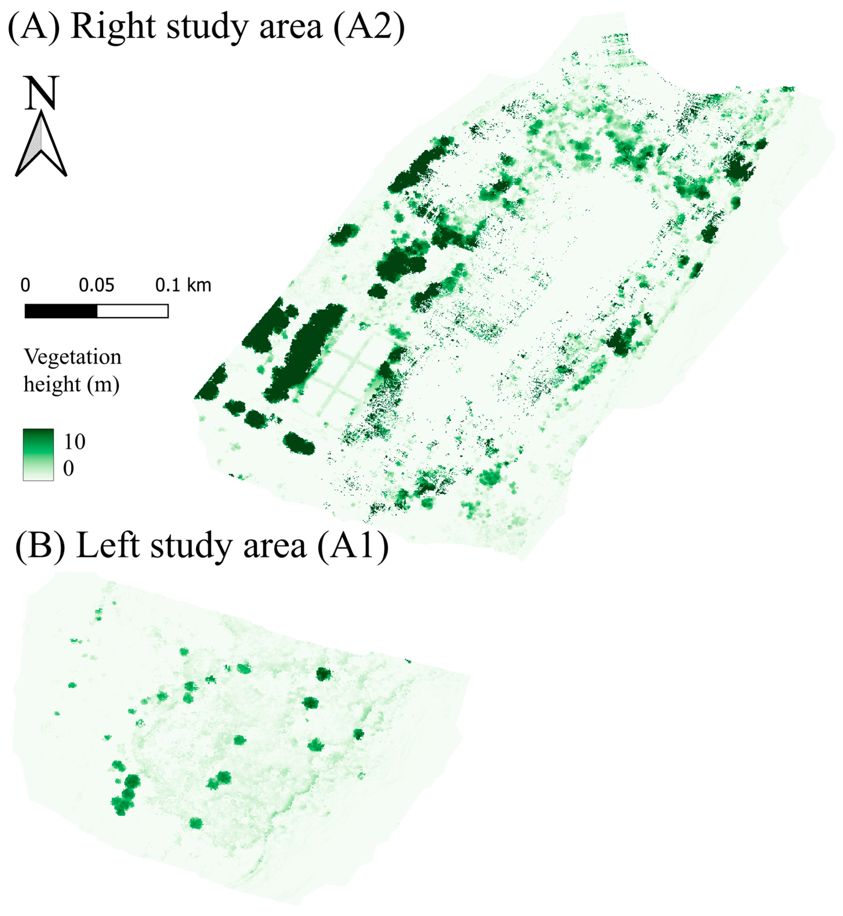
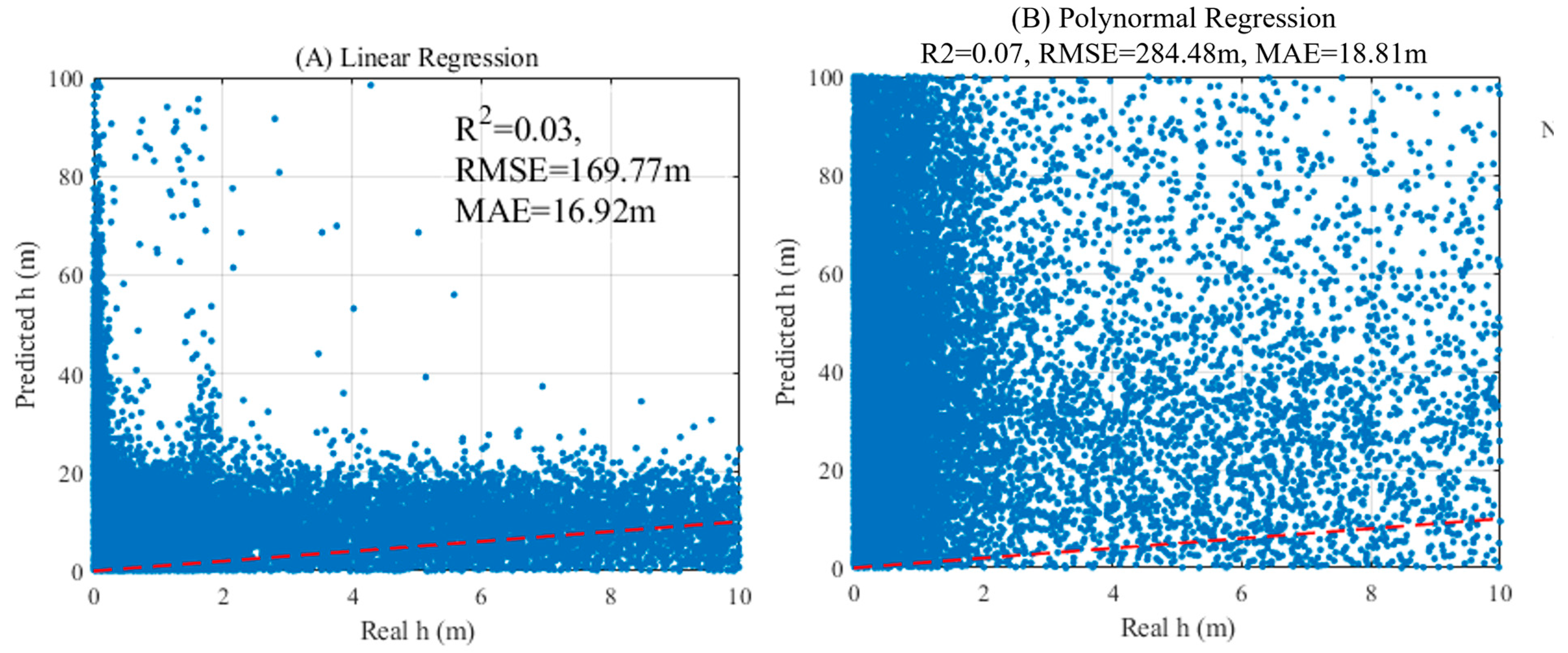
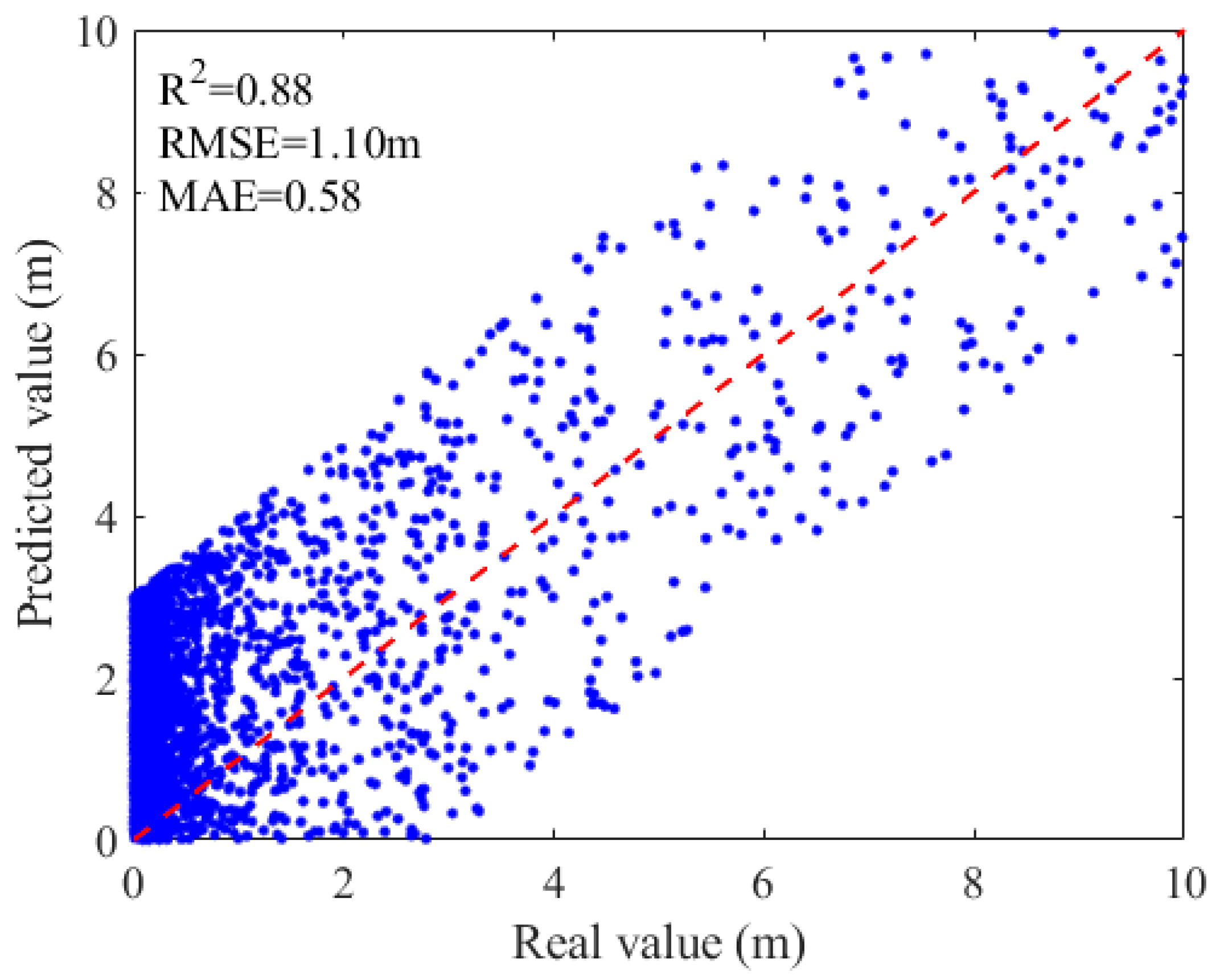
| Height (m) | Coverage Area 1 (%) | Coverage Area 2 (%) | Whole Area A1 + A2 (%) |
|---|---|---|---|
| <2 | 95.35 | 81.98 | 85.36 |
| 2–4 | 2.13 | 4.44 | 3.86 |
| 4–6 | 1.12 | 3.11 | 2.61 |
| 6–8 | 1.03 | 2.45 | 2.09 |
| >8 | 0.37 | 8.02 | 6.08 |
Disclaimer/Publisher’s Note: The statements, opinions and data contained in all publications are solely those of the individual author(s) and contributor(s) and not of MDPI and/or the editor(s). MDPI and/or the editor(s) disclaim responsibility for any injury to people or property resulting from any ideas, methods, instructions or products referred to in the content. |
© 2025 by the authors. Licensee MDPI, Basel, Switzerland. This article is an open access article distributed under the terms and conditions of the Creative Commons Attribution (CC BY) license (https://creativecommons.org/licenses/by/4.0/).
Share and Cite
Guo, Y.; Nones, M.; Zhou, Y.; Zhu, R.; Ding, W. Combination of UAV Imagery and Deep Learning to Estimate Vegetation Height over Fluvial Sandbars. Water 2025, 17, 3160. https://doi.org/10.3390/w17213160
Guo Y, Nones M, Zhou Y, Zhu R, Ding W. Combination of UAV Imagery and Deep Learning to Estimate Vegetation Height over Fluvial Sandbars. Water. 2025; 17(21):3160. https://doi.org/10.3390/w17213160
Chicago/Turabian StyleGuo, Yiwei, Michael Nones, Yuexia Zhou, Runye Zhu, and Wenfeng Ding. 2025. "Combination of UAV Imagery and Deep Learning to Estimate Vegetation Height over Fluvial Sandbars" Water 17, no. 21: 3160. https://doi.org/10.3390/w17213160
APA StyleGuo, Y., Nones, M., Zhou, Y., Zhu, R., & Ding, W. (2025). Combination of UAV Imagery and Deep Learning to Estimate Vegetation Height over Fluvial Sandbars. Water, 17(21), 3160. https://doi.org/10.3390/w17213160


