Abstract
The Erguna River, a Sino-Russian transboundary river, is vital for regional ecology, but land use impacts on its water quality remain unclear. This study aimed to reveal their response relationship. Using ArcGIS/ENVI, it classified land use in 2010 and 2016 into six types, and applied Pearson correlation to 10 monitoring sections’ water quality data. Results showed land use–water quality correlations were temporally and spatially variable: correlations weakened with increasing buffer distance, with the strongest associations within 1000 m. From 2010 to 2016, grassland shifted from a positive (water-purifying) to negative (pollutant-source) impact on water quality (BOD5 and arsenic), which was driven by area reduction and overuse; forestland transitioned from no significant effect to a positive (pollutant-intercepting) role, attributed to area expansion. Arable and construction land showed no significant correlations with water quality, due to low proportions of construction land in cross-border areas, and arable land is mostly distributed in areas far from the riverbank. This study provides critical scientific support for transboundary water resource cooperation and targeted ecological management of the Erguna River Basin.
1. Introduction
As important international water resources [1,2], transboundary rivers have far-reaching impacts on the socio-economy and environmental protection of riparian countries [3,4]. The Erguna River, a boundary river between China and Russia, is a critical transboundary water system in Northeast Asia [5]. The impact of land use change in its basin on water quality has become a core issue in regional environmental management [6,7]. With the intensification of human activities, transformations in land use patterns (such as agricultural expansion, urbanization, and deforestation) may significantly alter water quality through pathways like nutrient transport, sediment loading, and pollutant diffusion [8,9,10,11,12,13]. Research on water quality responses in transboundary basins not only involves ecological security but also concerns international cooperation and policy coordination [14,15].
In recent years, significant progress has been made in studies on the correlation between land use and water quality responses. Multiple studies have shown that agricultural land is closely linked to increased nitrogen and phosphorus concentrations in water bodies [16,17], while urbanization leads to heavy metal and organic pollution through increased impervious surfaces and sewage discharge [18,19,20]. Additionally, the reduction in natural vegetation cover exacerbates soil erosion, thereby affecting river suspended sediment content and habitat stability [21,22,23,24,25]. However, existing research predominantly focuses on single countries or small watershed scales, and the only research on cross-border pollution focuses on the impact of land use change in cross-border watersheds on hydrological conditions [26], improvement of land use classification methods in cross-border areas [27], and the relationship between land use change and cross-border haze [28]. There is a lack of research on the impact of land use change in cross-border watersheds on cross-border water quality. Due to difficulties in data acquisition and differences in management systems, the impact mechanisms of land use changes on transboundary water quality in the Erguna River Basin remain unclear [5,29,30].
Although the development of remote sensing technologies and hydrological models (such as SWAT and InVEST) has provided new tools for transboundary basin research in recent years [31,32], current studies still have the following limitations: (1) Most models lack validation with high-resolution land use and hydrological data in transboundary basins [33]. (2) The absence of long-term monitoring data restricts the quantitative analysis of dynamic water quality responses to land use changes [34,35]. (3) Research on collaborative management strategies in the China-Russia transboundary region is insufficient, urgently requiring the construction of an integrated assessment framework combining remote sensing and field monitoring. This study aims to reveal the ecological effects of land use changes in the Erguna River Basin through the coupling of multi-temporal remote sensing interpretation and water quality models, providing a scientific basis for transboundary water resource cooperation. This study conducts the first research on the response relationship between land use and water quality in the Sino-Russian cross-border region, which greatly expands the previous research scope that only focused on a single country or small watershed.
2. Materials and Methods
2.1. Study Area
The Erguna River, commonly known as the main source of Heilongjiang River, originates from the western slope of the Greater Khingan Mountains in China. Its main stream is the boundary river between China and Russia, flowing in a southwest-northeast direction. The river is 898 km long and has a drainage area of approximately 153,100 square kilometers within China. The left bank of the basin is located within the territory of Russia, including Nerchensky Zavod, Karaga, Prialgonsk, Redstone City, and Post Baikalsk and Borja. The right bank of the basin is located within the territory of China, including Manzhouli City, Erguna City, Genhe City, Chenbalhu Banner, Xinbalhu Left Banner, and Xinbalhu Right Banner in Inner Mongolia Autonomous Region. It is separated from the Nenjiang River system, the upper source of the Songhua River, by the Greater Khingan Range as a watershed. The Hailar River is a primary tributary of the Erguna River, flowing roughly in an east–west direction. Its source is the Dayan River, with the left bank fed by the Miandu River and the Yimin River, and the right bank fed by the Teni River and the Moergle River. The river is 622 km long and has a drainage area of 54,810 square kilometers, covering Yakeshi City, Ewenki Autonomous Banner, Hailar District, and other areas. The Genhe River is one of the largest tributaries of the Erguna River, originating in the southwest of the Greater Khingan Mountains and generally running in a northeast-southwest direction. It flows through the cities of Genhe and Erguna and is joined by tributaries such as the Tuli River and Ituri River.
The Erguna River basin belongs to a continental monsoon climate in the temperate zone, with strong winds and low temperatures in spring, mild and rainy summers, clear and cool autumn, and severe winter. The frost-free period is about 100 days, and the maximum freezing depth is 2.5–3.8 m. The distribution of precipitation within the year is uneven, with summer precipitation accounting for over 70% of the annual precipitation, winter snow accounting for 10–20% of the annual precipitation, and an average annual precipitation of 350 mm. The average annual runoff depths of Shiwei and Qiqian are 133 cubic meters per second and 292 cubic meters per second, respectively. The interannual variation in precipitation in the Hailar River is significant, with an average annual precipitation of 287–337 mm. Influenced by the monsoon, precipitation is mainly concentrated in June to September, accounting for 80–84% of the annual precipitation. The average temperature decreases from west to east, with a multi-year average temperature of −1.3–2.6 °C. The annual evaporation is 1250–1533 mm, which is 3.2–5.1 times the average annual precipitation. The research area is located in an alpine region with a long ice period and a thick ice layer. There may be ice on the ice or even continuous freezing at the bottom, and even ice dams may form during the river opening period.
2.2. Data Sources
The research data mainly includes remote sensing image data and water quality data of the Erguna River Basin. The remote sensing image data are Landsat TM in 2010 with a resolution of 30 m, and high-resolution satellite remote sensing image data in 2016 with a resolution of 2 m. The water quality data is sourced from the Environmental Monitoring Center of Hulunbuir City, Inner Mongolia Autonomous Region, which includes water quality data from 10 monitoring sections in the Erguna River Basin. The water quality monitoring frequency is once a month, with 12 periods per year (of which the Yimu River section only samples one period due to high latitude). Due to the fact that there is only one period of data for the Yimu River section, this period of data is used as the annual average data, while the annual average data for other sections is the average of monthly monitoring data.
The monitoring points, indicators, monitoring frequency and detection methods are shown in Table 1.

Table 1.
List of Monitoring Points and Monitoring Indicators.
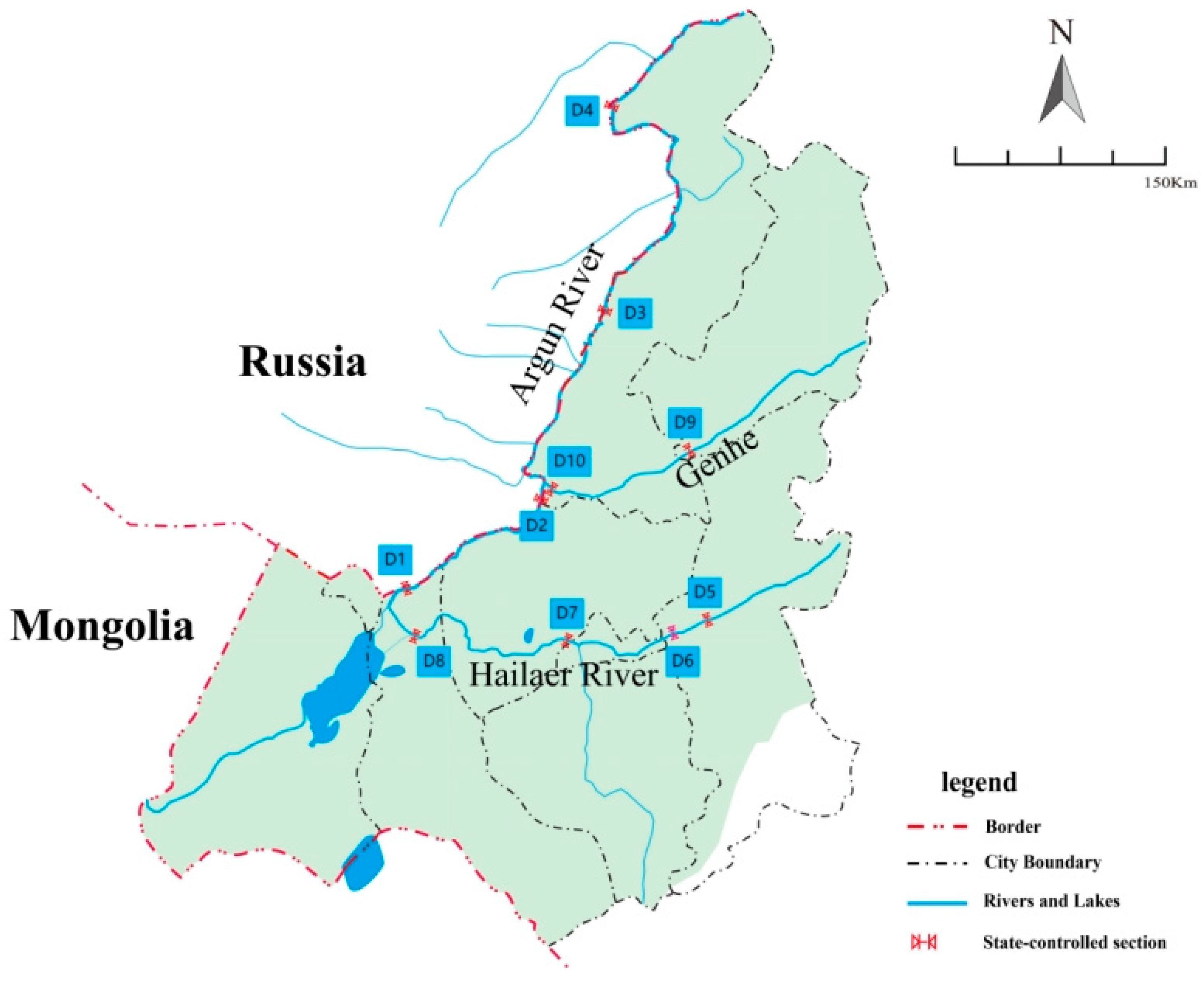
In this paper, we selected 10 water quality monitoring sections in the Erguna River Basin, among which there are 4 water quality monitoring sections in the main stream. From upstream to downstream, they are Galoto, Heishantou, Shiwei, and Yimu Rivers, all of which belong to state-controlled river sections. The Hailar River has four water quality monitoring sections, namely No. 8 Pasture, Yakeshi, Taohai, and Cuogang, all of which belong to the state-controlled river section. The Genhe River has two monitoring sections, from upstream to downstream are Yuliang and the Genhekou section. Yuliang belongs to the municipal-controlled river section, while the Genhekou section belongs to the municipal-controlled river section. The specific distribution of each water quality monitoring section is shown in Figure 1. For the convenience of representation, D1, D2, D3, D4, D5, D6, D7, D8, D9, and D10 are used to represent 10 monitoring sections within the Galoto, Heishantou, Shiwei, Yimu River, No. 8 Pasture, Yakeshi, Taohai, Cuogang, Yuliang, and Genhekou areas, respectively.
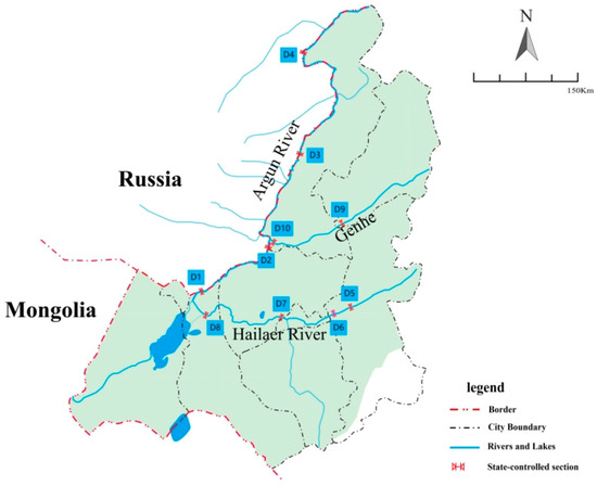
Figure 1.
Distribution of Monitoring Sections in the Erguna River (Argun River) Basin.
2.3. Remote Sensing Image Processing
With the support of ENVI 5.0, remote sensing image data is preprocessed through correction, registration, and stitching to obtain remote sensing image maps of the Erguna River Basin. In this study, the maximum likelihood supervised classification method [41] was used to extract the land use information of the study area in combination with visual interpretation to obtain the land use type classification data of each year and produce the land use map of the study area. According to the principles of land use classification, the land use status of the Erguna River Basin, and research needs, the land use types are classified into six major categories: water bodies, forest land, grassland, cultivated land, construction land, and other land (the kappa coefficients for 2010 and 2016 were 0.88 and 0.91, respectively). Considering that there is no practical significance between the water body and water quality of the river itself, the water body in the land use type studied in this article refers to the part that removes the water surface of the river.
2.4. Establishment of Riverbank Zones in Cross-Border Areas
Firstly, establish a monitoring section, load the document of monitoring section coordinate points in ArcGIS 10.1 based on the longitude and latitude coordinates of each monitoring section, and assign them to their geographic coordinate system. Establish a 5 km buffer zone with the monitoring section as the center, perpendicular to the river channel, and upstream towards the river. Establish river buffer zones of 100, 300, 500, 1000, 2000, and 4000 m on both sides of the river surface. Intersect the established monitoring section buffer zone with the actual river water surface buffer zone to obtain buffer zones of different scales for each monitoring section. Erase the river surface based on the established buffer zone. In order to ensure that the buffer zones of each monitoring section are a single surface, feature fusion is carried out on the buffer zone after erasing the river water surface, mainly to prevent the same land use type from appearing multiple times when the river buffer zone intersects with land use. Intersect the buffer zones of each fused monitoring section with land use data to obtain land use data for each monitoring section buffer zone. Assign projection coordinates to the data, calculate the area of land use types, and separately calculate the land use type area of each monitoring section in different buffer zones.
2.5. Analysis Method for Correlation Between Water Quality and Land Use
Correlation analysis can help study the correlation between random variables and explore their direction and degree of correlation. The water quality indicators and land use type parameters in each buffer zone in this article satisfy a normal distribution. Therefore, Pearson correlation analysis is used to reveal the response relationship between water quality indicators and land use changes. The water quality monitoring data adopts the monthly average value throughout the year (excluding the Yimu River section).
3. Results
3.1. Basic Situation of Water Quality in Cross-Border Areas
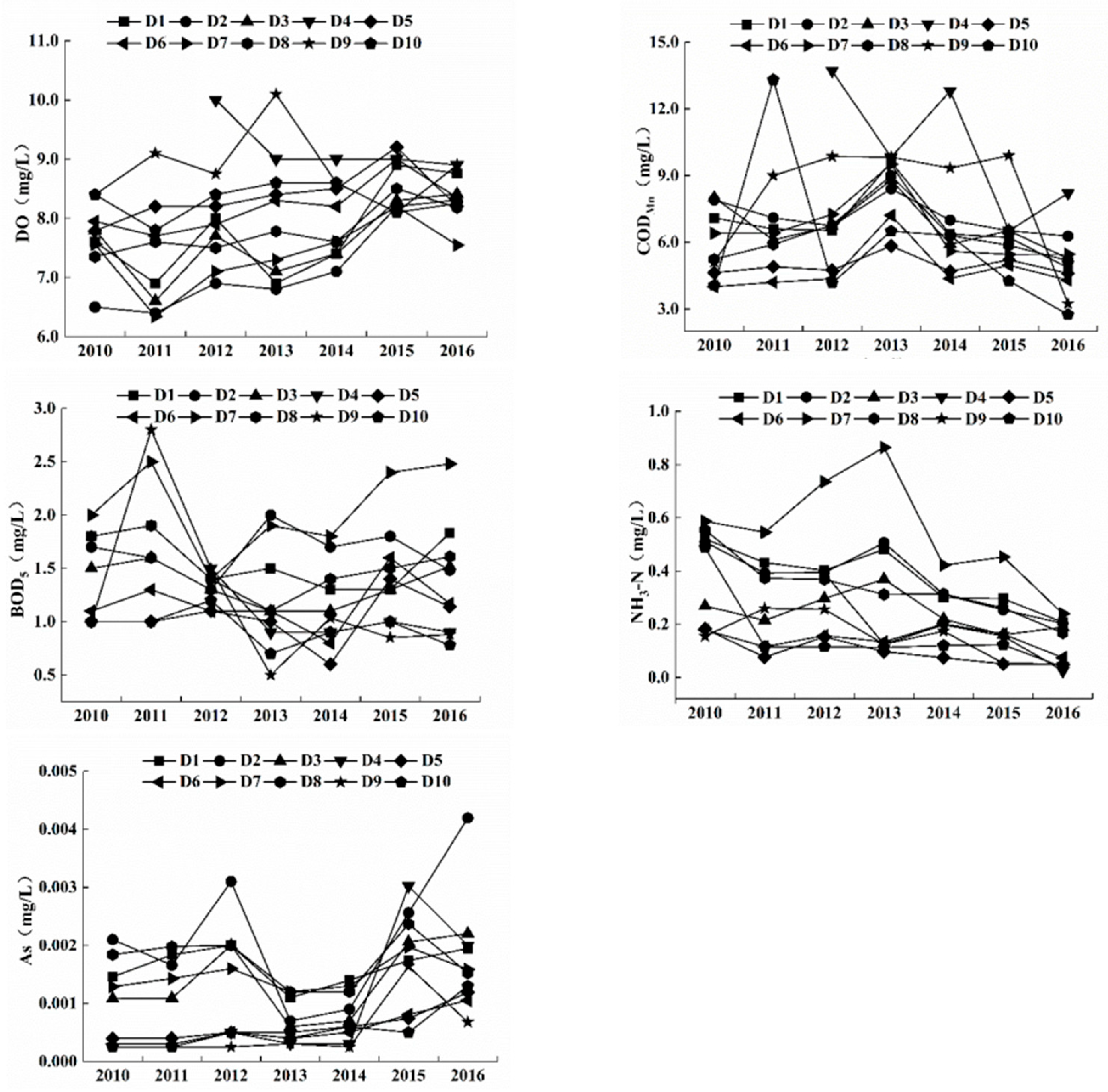
Figure 2 reflects the changes in the annual average content of DO (dissolved oxygen), CODMn (chemical oxygen demand), BOD5 (five-day biochemical oxygen demand), ammonia nitrogen (NH3-N), and As (arsenic) at various sections of the Erguna River from 2010 to 2016. From the figure, it can be seen that from 2010 to 2016, except for D3, the average annual value of DO in each section showed an overall upward trend, ranging from 7.5 to 9.0 mg/L. Although the CODMn content fluctuated significantly during this period, it showed an overall downward trend, all below 9.0 mg/L; BOD5 showed significant differences and changes in various sections, but its peak value is below 3 mg/L. The overall NH3-N content also shows a downward trend, with the content at each section being below 0.4 mg/L in 2016. The overall As content is low, and the upward trend is not obvious.
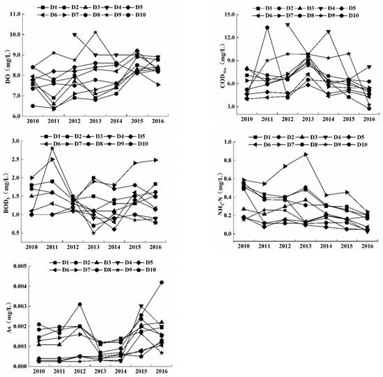
Figure 2.
Water quality changes at various monitoring sections of the Erguna River Basin from 2010 to 2016.
3.2. Temporal and Spatial Changes in Land Use Structure of Riverbank Zones in Cross-Border Areas
Land use data of different types from two periods (2010 and 2016) were selected to first classify and then statistically analyze the land use types in the riparian buffer zones of 10 monitoring sections in the Erguna River Basin. The riparian zone is a buffer zone established by tracing the monitoring section 5 km upstream of the river, and a buffer zone of 4000 m is established on both sides of the river surface.
Use a single land use dynamic index K to quantitatively reflect changes in land use types. The formula is as follows:
In the formula: K is the dynamic index of a certain land use type; Ua and Ub represent the area of land use types at the beginning and end of the research period, T represents the research period, and when T is measured in years, K represents the annual change rate of a certain land use type.
The changes in land use structure of the Erguna River riparian zone in 2010 and 2016 are shown in Table 2. From the table, it can be seen that grassland and forestland are the main land use types in the Erguna River riparian zone, with grassland area accounting for about 50% and forest land area accounting for over 20%.

Table 2.
Time variation in land use structure in the Erguna River riparian zone.
From 2010 to 2016, there was no significant change in the land use structure of the riparian zone, but each land use type showed varying degrees of increase or decrease. The main changes in quantity are as follows: the grassland area has decreased, from 319.36 km2 in 2010 to 270.36 km2 in 2016, and its proportion has also decreased from 58.25% to 48.25%. The area of forestland has increased, with its proportion increasing from 21.90% in 2010 to 24.01%. The water bodies, arable land area, and other land use have also increased, while other land use has increased significantly. The area of construction land has decreased.
From the perspective of change dynamics, the most significant change is in other land use types, with an annual change rate of nearly 30%. The changes in other types are relatively small, except for water bodies where the annual change rate is greater than 10%; all other types have an annual change rate of less than 10%.
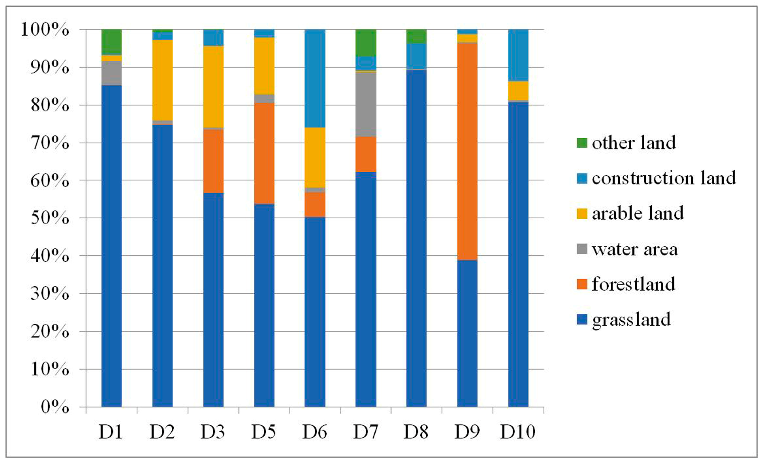
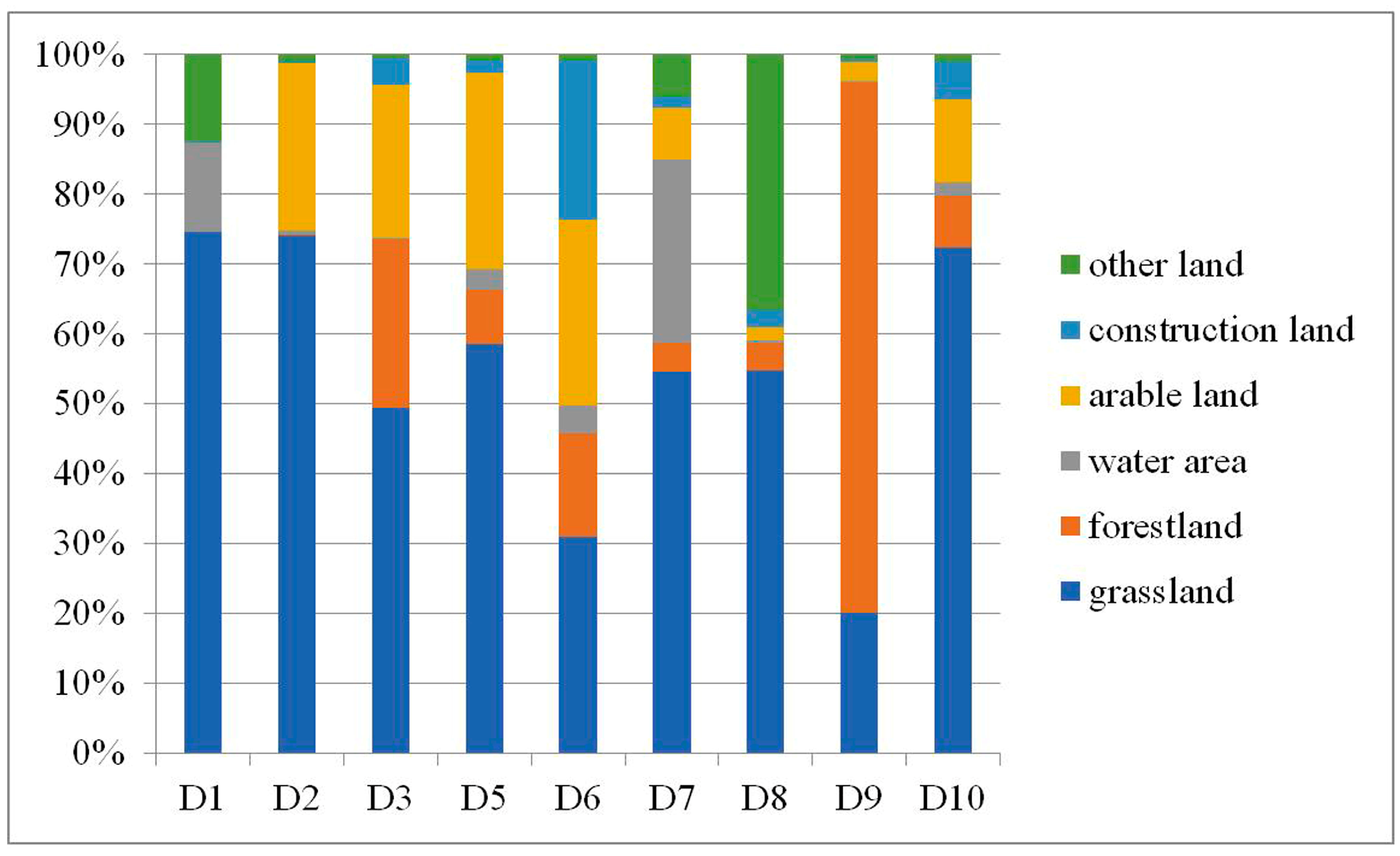
Figure 3 and Figure 4 show the proportion of land use types in the buffer zone of the Erguna River, Hailar River, and Genhe River in 2010 and 2016, respectively. The comparison shows that the grassland area in the buffer zone of the Erguna River, Hailar River, and Genhe River has decreased, while other land use types have changed to varying degrees. The grassland area of section D1 in the Erguna River Basin has decreased, while the water bodies and other land areas have increased, mainly influenced by human activities. The D2 section is mainly characterized by a decrease in arable land area, while the land use structure of sections D3 and D4 remains basically unchanged.
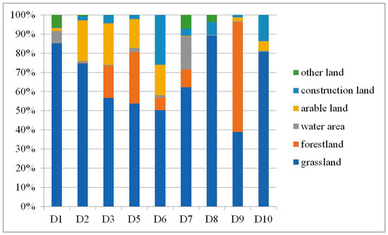
Figure 3.
The proportion of land use types in the riparian zones of each monitoring section in 2010.
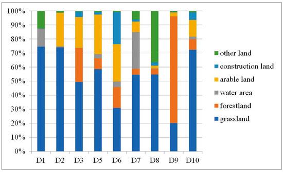
Figure 4.
The proportion of land use types in the riparian zones of each monitoring section in 2016.
The forestland area of section D5 in the Hailar River Basin has decreased, while the arable land area has increased. The grassland area of section D6 has decreased, while the arable land area has increased. The water bodies and arable land area of section D7 have increased. The grassland area of section D8 has decreased, while other land areas have significantly increased. Overall, the significant characteristics of this region are a decrease in grassland area, an increase in arable land area, and an increase in other land use with significant increases.
The forestland area of section D9 in the Genhe River Basin has increased, while the grassland area has decreased. In recent years, the government of Genhe City has strengthened afforestation and mountain closure for afforestation, and the increase in forestland area may be the result of the evolution of low shrubs into tree forests. The arable land area of D10 section has increased, while the construction land area has decreased.
3.3. Correlation Analysis Between Land Use Types and Water Quality
Pairwise correlation analysis was conducted on the average water quality indicators of the 9 monitoring sections in 2010 and 2016, except for the D4 section of the Yimu River, and the land use area of different buffer zones at different distances. The results are shown in Table 3 and Table 4.

Table 3.
Correlation analysis between water quality and land use type (2010).

Table 4.
Correlation analysis between water quality and land use type (2016).
Table 3 reflects the correlation between water quality and land use in 2010.
- (1)
- Within the buffer zones of 100, 300, and 500 m, there is a significant negative correlation between grassland and BOD5 at the 0.05 level, with the most significant correlation at the 300 m buffer zone, indicating that the increase in grassland is beneficial for improving water quality.
- (2)
- Within the buffer zones of 300, 500, 1000, and 2000 m, there is a significant negative correlation between water bodies and DO, a significant positive correlation between water bodies and BOD5 at buffer zones of 300, 500, 1000, and 2000 m, and a highly significant positive correlation between water bodies and BOD5 at buffer zones of 4000 m.
- (3)
- There is a significant positive correlation between construction land and arsenic only in the 100 m buffer zone, and there is no significant correlation with other water quality indicators.
- (4)
- In terms of other land use, within a 100 m buffer zone, there is a significant correlation with CODMn and arsenic. Within a buffer zone of 300 and 500 m, there is a significant correlation with DO and BOD5. Within the buffer zones of 1000, 2000, and 4000 m, there is a significant correlation with BOD5 and NH3-N.
- (5)
- The correlation between forest land, cultivated land, and various water quality indicators is not significant in each buffer zone.
Table 4 reflects the correlation between various water quality indicators and different land use types in 2016.
- (1)
- Water quality factors and grasslands. Within the buffer zones of 100, 300, 500, 1000, and 2000 m, the water quality factor arsenic was significantly positively correlated with the grassland at the 0.05 level, while the other water quality factors DO, CODMn, BOD5, NH3-N were not significantly correlated with the grassland in each buffer zone.
- (2)
- Water quality factors and forest land. Within the buffer zones of 100, 300, and 500 m, there was a significant negative correlation between forest land and CODMn and NH3-N at the 0.01 level, and the correlation with CODMn increased with the increase in buffer zone distance, while the correlation with NH3-N decreased with the increase in buffer zone distance. Within a 1000 m buffer zone, there is a significant negative correlation with CODMn, NH3-N, BOD5, and arsenic at the 0.05 level.
- (3)
- Water quality factors and water bodies. The correlation with DO gradually decreases as the buffer distance increases, with a significant negative correlation in 100 and 300 m buffers and DO at the 0.01 level, and a significant negative correlation in 500 and 1000 m buffers at the 0.05 level. BOD5 showed a significant positive correlation at the 0.05 level in the buffer zone waters of 100, 300, 500, 1000, and 2000 m, and a significant positive correlation at the 0.01 level in the buffer zone waters of 4000 m.
- (4)
- The correlation between water quality factors and cultivated land, construction land, and other land use in each buffer zone is not significant.
4. Discussion
4.1. Interpretation of Water Quality Evaluation Results of the Erguna River
In accordance with the Environmental Quality Standards for Surface Water of China (GB3838-2002) [42], the contents of DO, permanganate index (CODMn), five-day biochemical oxygen demand (BOD5), and arsenic in each monitoring section of the Erguna River in 2016 all met the Class I water quality standard, while the highest content of ammonia nitrogen (NH3-N) also complied with the Class II standard. All indicators can also meet the EU Water Framework Directive and related standards (in a “good” state). Compared with the water quality in 2010, the overall water quality of the river showed an improving trend. This result indicates that, as a cross-border river between China and Russia, the Erguna River currently maintains a good water quality base without obvious pollution accumulation. This may be attributed to the relatively low intensity of human activities in the basin and the strong natural purification capacity of the river ecosystem.
4.2. Characteristics of Land Use Changes in the Erguna River Basin
From a temporal perspective, the overall land use structure of the basin remained stable during 2010–2016 (with the core order of grassland > forest land > arable land > other land types). However, the area of grassland and construction land decreased, while the area of other land types increased. This phenomenon is consistent with the “grassland degradation—expansion of other land uses” pattern observed in similar semi-arid basins by Xiang et al. [43] and Liang et al. [44]. The primary cause of grassland reduction is desertification, and the recent climate conditions of rising temperatures and decreasing precipitation. The reduction in construction land may be directly related to the overall relocation policy for herdsmen in areas severely affected by grassland desertification, reflecting the coordinated adjustment between regional ecological protection and human residential needs.
From a spatial perspective, along the main stream of the Erguna River from upstream to downstream, the proportion of grassland decreases while that of forest land increases. This spatial pattern is closely associated with the topographic differences in the basin: the upstream area is dominated by mountains, while the downstream area has flat and open terrain, which is more suitable for grassland distribution. Additionally, the high proportion of arable land in the D2 and D3 sections (near Heishantou Town and Shiwei Town) and the high proportion of construction land in the D6 section (Yakeshi City) both reflect the “match between land use types in human activity-concentrated areas and population density as well as the intensity of production activities”. In contrast, the tributary Genhe River exhibits the spatial characteristic of “more forest land in the upstream and more grassland in the downstream”, which further verifies the decisive role of topography (mountains in the upstream and open plains in the downstream) in the spatial differentiation of land use.
4.3. Correlation Mechanism Between Land Use Types and Water Quality in the Erguna River Basin
4.3.1. Grassland and Water Quality: Transition from “Improvement” to “Negative Impact”
In 2010, grassland showed a significant negative correlation with BOD5, indicating that grassland had a certain purification effect on water quality at that time. However, in 2016, grassland exhibited a strong positive correlation with arsenic and no significant positive correlation with other water quality indicators. This result contradicts the traditional perception that “grassland improves water quality” but is consistent with the conclusions of Xiang et al. [43] and Liang et al. [44] that “grassland may serve as a source of pollutants in water bodies”. The core mechanism lies in the fact that the Erguna River Basin is an important animal husbandry base in China (with nearly 100 million mu of usable natural grassland), and arsenic compounds are widely used in animal husbandry to promote livestock growth and enhance disease resistance [45]. The feces of grazing livestock tend to remain on the surface under semi-arid climatic conditions (where temperature and moisture affect fecal decomposition) and enter the river through surface runoff. Meanwhile, if the livestock carrying capacity per unit area of grassland exceeds the limit, the decomposition of a large amount of feces can lead to point source pollution [46,47]. The transition of grassland’s impact on water quality from “positive” to “negative” between 2010 and 2016 is also related to the significant reduction in grassland area. Blind pursuit of economic growth and improper management practices have weakened the grassland’s ability to intercept pollutants, leading to increased loss of nutrients such as nitrogen and ultimately exerting a negative impact on water quality.
4.3.2. Forest Land and Water Quality: Temporal and Spatial Differences in the “Sink” Effect
In 2016, within the 1000 m buffer zone, forest land showed a significant negative correlation with CODMn, BOD5, NH3-N, and arsenic, demonstrating a “sink” effect of forest land on pollutants. This is consistent with other research results [48,49,50]—the permeable underlying surface of forest land can intercept the migration of pollutants, and its roots can absorb pollutants, thereby alleviating water pollution. Notably, there was no significant correlation between forest land and water quality indicators in 2010. This may be due to the small area of forest land or the underdeveloped forest stand structure (e.g., tree species, canopy density) in 2010, which had not yet formed an effective purification capacity, reflecting the “time lag” in the water quality improvement effect of forest land.
4.3.3. Water Bodies and Water Quality: Stable “Negative Impact”
From 2010 to 2016, water bodies (mainly wetlands such as inland tidal flats, pond water surfaces, and swamp lands) showed a negative correlation with DO and As, and a positive correlation with CODMn, BOD5, and NH3-N (with significant correlations with DO and BOD5). This indicates that water bodies generally exert a negative impact on water quality. Although wetlands have the functions of water storage, regulation, and pollutant absorption [51], the annual increase in water body area in this study did not change the strength of its correlation with water quality indicators. This may be because the water bodies in the basin are dominated by “stagnant wetlands”, where pollutants accumulate and are then input into the river through runoff. Additionally, the purification capacity of wetlands probably has reached saturation, so the increase in area cannot further enhance the purification effect.
4.3.4. Arable Land, Construction Land, Other Land, and Water Quality: Uncertainty of Impacts
Overall, there was no significant correlation between arable land, construction land, and water quality indicators. This differs greatly from the conclusions of Zhang et al. [52] and Iqbal et al. [53] that “arable land and construction land exacerbate water quality deterioration”. The main reason is that the proportion of construction land in the cross-border area of the study is low and decreasing year by year, while arable land is mostly distributed in areas far from the riverbank, making it difficult for pollutants to enter the river through runoff. In 2016, there was no significant correlation between other land uses and water quality indicators, indicating that other land uses have a limited impact on water quality. This may be because other land uses (e.g., unutilized land) are dominated by “non-polluting land types” and account for a small area, failing to form large-scale pollution input.
4.3.5. Impact of Buffer Zone Distance on the “Land Use–Water Quality” Correlation
When the buffer zone exceeds 1000 m, the correlation between water quality and land use is generally weak; within 1000 m, the correlation is more significant. This conforms to the general law of “distance decay effect” in the impact of land use on water quality—the closer the land use type is to the riverbank, the easier it is for pollutants to enter the river through runoff, leaching, and other processes. Specifically, in 2016, the correlation between grassland and As was the highest in the 100 m nearshore buffer zone and 2000 m buffer zone, indicating that grassland in these two regions is an important “source” of As. The forest land in the 300 m buffer zone showed the highest overall correlation with water quality indicators, suggesting that afforestation in this area has the optimal effect on improving water quality, providing a clear spatial reference for ecological restoration in the basin.
4.4. Limitations of the Study
Temporal Scale Limitation: This study only compares data from two time points (2010 and 2016), failing to reflect the long-term dynamic changes in the correlation between land use and water quality (e.g., interannual fluctuations, seasonal differences). It may also miss the interference of abnormal climate years (e.g., extreme precipitation, drought) on the correlation between the two.
Indicator Coverage Limitation: Only five water quality indicators (DO, CODMn, BOD5, NH3-N, arsenic) were selected, excluding other key pollutants such as total nitrogen, total phosphorus, and heavy metals (e.g., cadmium, lead). This may underestimate the potential pollution contribution of some land use types (e.g., arable land). Additionally, land use types were not further subdivided (e.g., grassland was not divided into natural grassland and artificial grassland, and forest land was not divided into coniferous forest and broad–leaved forest), making it difficult to accurately identify the differential impacts of different subtypes on water quality.
Depth Limitation of Mechanism Research: The correlation between land use and water quality was only inferred through correlation analysis, without combining field in situ observations (e.g., monitoring of pollutant migration flux) and laboratory simulation experiments (e.g., pollutant leaching rate under different land use types). The interpretation of the correlation mechanism remains at the “phenomenal correlation” level, lacking quantitative verification. In the future, scientists from China and Russia can jointly conduct field experiments and research and establish a data exchange mechanism.
5. Conclusions
5.1. Main Research Findings
Water Quality Status: In 2016, the core water quality indicators (DO, CODMn, BOD5, arsenic) in each monitoring section of the Erguna River met the Class I standard, and NH3-N met the Class II standard. The overall water quality was good and showed an improving trend compared with 2010.
Land Use Changes: From 2010 to 2016, the overall land use structure of the basin remained stable (with grassland and forest land as the dominant types). However, the area of grassland and construction land decreased (the main cause of grassland reduction was desertification and climate drought), and the area of other land types increased. Spatially, along the main stream from upstream to downstream, the proportion of grassland decreased and that of forest land increased, while the opposite trend was observed in the tributary Genhe River. Topography was the main driving factor for these changes.
“Land Use–Water Quality” Correlation: Grassland transitioned from a “water quality improver” in 2010 to an important “source” of arsenic in 2016. Within the 1000 m buffer zone, forest land exhibited a significant “sink” effect on pollutants, and afforestation in the 300 m buffer zone had the optimal effect on improving water quality. Water bodies exerted a stable negative impact on water quality. Arable land, construction land, and other land uses had limited impacts on water quality. The “land use–water quality” correlation decayed with buffer distance, and the correlation was much significant within 1000 m.
5.2. Scientific and Policy Significance
This study reveals the temporal and spatial heterogeneity of the “land use–water quality” correlation in semi-arid cross-border basins, verifies the “pollution source” effect of grassland under high livestock carrying capacity, the “pollution sink” effect of forest land, and the “decay effect” of buffer zone distance. It provides a reference paradigm for studies on the “land use–water quality” correlation in similar basins (e.g., other cross-border rivers in the northeastern border of China).
It clarifies the key directions for ecological protection in the basin. To alleviate grassland degradation and arsenic pollution input, it is necessary to reduce grazing pressure and optimize grassland management. Afforestation projects should be prioritized in the 300 m nearshore buffer zone to strengthen the interception and purification of pollutants by forest land. Meanwhile, considering that the Erguna River is a cross-border river between China and Russia, China is located in the upstream area, and Russia has slightly stricter water quality standards [54], it is essential to strengthen the supervision of the ecological environment in the basin to ensure cross-border water quality safety and maintain the friendship of ecological cooperation between China and Russia.
5.3. Future Research Directions
Long-term continuous monitoring data should be added, and water quality indicators such as total nitrogen, total phosphorus, and multiple heavy metals should be supplemented.
Combining field monitoring of pollutant flux and laboratory simulation experiments, the migration rate and transformation efficiency of pollutants under different land use types should be quantitatively analyzed to clarify the quantitative mechanism of the “land use–water quality” correlation. Hydrological models (e.g., SWAT model) could be introduced to simulate water quality changes under different land use scenarios, providing predictive support for land use planning in the basin.
Joint investigations on land use and water quality in the entire Erguna River Basin (both Chinese and Russian sides) could be conducted with Russia to compare and analyze the differential characteristics and coordinated protection needs of the two sides, providing a scientific basis for the coordinated ecological governance of cross-border basins.
Author Contributions
Conceptualization, Y.X. and L.W.; methodology, S.G. and T.L.; software, L.W. and J.J.; validation, L.W. and S.G.; formal analysis, S.G.; investigation, Y.X. and J.J.; writing—original draft preparation, Y.X.; writing—review and editing, S.G. and T.L.; visualization, S.G.; supervision, T.L.; project administration, Y.X. and T.L.; funding acquisition, Y.X. All authors have read and agreed to the published version of the manuscript.
Funding
This research was funded by the Major Science and Technology Program for Water Pollution Control and Treatment of China, grant number 2014ZX07503004, and the Natural Science Foundation of Jiangsu Province, grant number BK20181111.
Data Availability Statement
The original contributions presented in this study are included in the article. Further inquiries can be directed to the corresponding authors.
Conflicts of Interest
The authors declare no conflicts of interest.
References
- Fu, J.; Lu, T.; Xu, B.; Li, J.; Zhou, J.; Xiong, B.; He, Z. Water Resources Allocation in a Transboundary River Based on a Rubinstein Bargaining Model. Water Resour. Manag. 2024, 38, 639–663. [Google Scholar] [CrossRef]
- Wang, X.; Chen, Y.; Li, Z.; Fang, G.; Wang, F.; Hao, H. Water resources management and dynamic changes in water politics in the transboundary river basins of Central Asia. Hydrol. Earth Syst. Sci. 2021, 25, 3281–3299. [Google Scholar] [CrossRef]
- Zhang, F.; Kong, L. Research on the Globalization of the Convention on the Protection and Use of Cross border Watercourses and International Lakes and Its Impact on China. Wuhan Univ. Int. Law Rev. 2016, 19, 281–299. (In Chinese) [Google Scholar]
- Lodge, J.W.; Dansie, A.P.; Dang, N.M.; Johnson, F. Modelling the availability of water, energy, and food resources in transboundary river basins to achieve Sustainable Development Goals 2, 6, and 7. Sci. Total Environ. 2024, 949, 175186. [Google Scholar] [CrossRef]
- Xie, Y.; Huo, X.; Hu, C.; Tao, Y. Contamination, Ecological Risk and Source Apportionment of Heavy Metals in the Surface Sediments in the Hailar River, the Upper Source of the Erguna River between China and Russia. Sustainability 2023, 15, 3655. [Google Scholar] [CrossRef]
- Yu, H.; Zhu, W.; Jin, R. Future soil erosion assessment based on changing land cover and different climate change scenarios in a transboundary river basin. Int. J. Digit. Earth 2024, 17, 2301434. [Google Scholar] [CrossRef]
- Ly, K.; Metternicht, G.; Marshall, L. Transboundary River Basins, Scenarios of Hydropower Development and Operation under Extreme Climate Conditions. Sci. Total Environ. 2022, 803, 149828. [Google Scholar] [CrossRef]
- Winkler, K.; Fuchs, R.; Rounsevell, M.; Herold, M. Global land use changes are four times greater than previously estimated. Nat. Commun. 2021, 12, 2501. [Google Scholar] [CrossRef]
- Liang, J.; Li, S.; Li, X.D.; Li, X.; Liu, Q.; Meng, Q.; Lin, A.; Li, J. Trade-off analyses and optimization of water-related ecosystem services (WRESs) based on land use change in a typical agricultural watershed, Southern China. J. Clean. Prod. 2021, 279, 123851. [Google Scholar] [CrossRef]
- Deng, G.Y.; Jiang, H.B.; Zhu, S.Y.; Wen, Y.; He, C.G.; Wang, X.; Sheng, L.X.; Guo, Y.; Cao, Y.Y. Projecting the response of ecological risk to land use/land cover change in ecologically fragile regions. Sci. Total Environ. 2024, 914, 169908. [Google Scholar] [CrossRef]
- Qian, Y.; Dong, Z.; Yan, Y.; Tang, L. Ecological risk assessment models for simulating impacts of land use and landscape pattern on ecosystem services. Sci. Total Environ. 2022, 833, 155218. [Google Scholar] [CrossRef] [PubMed]
- Quevedo, R.P.; Velastegui-Montoya, A.; Montalván-Burbano, N.; Morante-Carballo, F.; Korup, O.; Rennó, C.D. Land use and land cover as a conditioning factor in landslide susceptibility, a literature review. Landslides 2023, 20, 967–982. [Google Scholar] [CrossRef]
- Barati, A.A.; Zhoolideh, M.; Azadi, H.; Lee, J.H.; Scheffran, J. Interactions of land-use cover and climate change at global level, How to mitigate the environmental risks and warming effects. Ecol. Indic. 2023, 146, 109829. [Google Scholar] [CrossRef]
- Wang, X.X.; Cui, B.L.; Chen, Y.N.; Feng, T.; Li, Z.; Fang, G.H. Dynamic processes of water conflicts and their coupling with water crises in Asia’s transboundary river basin. Ecol. Indic. 2025, 172, 113325. [Google Scholar] [CrossRef]
- Khoshnoodmotlagh, S.; Verrelst, J.; Daneshi, A.; Mirzaei, M.; Azadi, H.; Haghighi, M.; Hatamimanesh, M.; Marofi, S. Transboundary Basins Need More Attention, Anthropogenic Impacts on Land Cover Changes in Aras River Basin, Monitoring and Prediction. Remote Sens. 2020, 12, 3329. [Google Scholar] [CrossRef]
- Choi, M.; Lee, C.; Kim, L.H.; Choi, S.H.; Bong, Y.S.; Lee, K.S.; Shin, W.J. Assessing sources of nutrients in small watersheds with different land-use patterns using TN, TP, and NO3− -N. J. Hydrol.-Reg. Stud. 2024, 55, 101958. [Google Scholar] [CrossRef]
- Chen, Y.T.; Mundle, S.O.C.; Reid, T.; Weisener, C. Nutrient variability and sediment contribution along a mixed land-use within Sturgeon Creek-Lake Erie watershed. J. Environ. Manag. 2023, 347, 119139. [Google Scholar] [CrossRef]
- Taka, M.; Sillanpää, N.; Niemi, T.; Warsta, L.; Kokkonen, T.; Setälä, H. Heavy metals from heavy land use? Spatio-temporal patterns of urban runoff metal loads. Sci. Total Environ. 2022, 817, 152855. [Google Scholar] [CrossRef]
- Niu, S.P.; Xia, Y.R.; Yang, C.H.; Liu, C.G. Impacts of the steel industry on sediment pollution by heavy metals in urban water system. Environ. Pollut. 2023, 335, 122364. [Google Scholar] [CrossRef]
- Fang, T.; Wang, H.; Liang, Y.Y.; Cui, K.; Yang, K.; Lu, W.X.; Li, J.; Zhao, X.X.; Gao, N.; Yu, Q.Z.; et al. Source tracing with cadmium isotope and risk assessment of heavy metals in sediment of an urban river, China. Environ. Pollut. 2022, 305, 119325. [Google Scholar] [CrossRef]
- Wang, K.L.; Zhou, J.; Tan, M.L.; Lu, P.D.; Xue, Z.H.; Liu, M.Y.; Wang, X.P. Impacts of vegetation restoration on soil erosion in the Yellow River Basin, China. CATENA 2024, 234, 107547. [Google Scholar] [CrossRef]
- Guan, Q.; Feng, L.; Tang, J.; Park, E.; Ali, T.A.; Zheng, Y. Trends in River Total Suspended Sediments Driven by Dams and Soil Erosion, A Comparison between the Yangtze and Mekong Rivers. Water Resour. Res. 2022, 58, e2022WR031979. [Google Scholar] [CrossRef]
- Li, W.Y.; Xia, Y.Y.; Tan, X.H.; Gan, F.L.; Jiang, L.S.; Xu, X.Y.; Yan, Y.J.; Fan, Y.C.; Pu, J.B. Does the returning farmland to grassland (retiring grassland) improve the soil aggregate stability in erosion and deposition sites? CATENA 2025, 255, 109023. [Google Scholar] [CrossRef]
- Wen, B.; Liu, C.X.; Tian, X.; Zhang, Q.; Huang, S.L.; Zhang, Y.Y. Interactive Effects of Ecological Land Agglomeration and Habitat Quality on Soil Erosion in the Jinsha River Basin, China. Land 2024, 13, 229. [Google Scholar] [CrossRef]
- Ly, K.; Metternicht, G.; Marshall, L. Linking Changes in Land Cover and Land Use of the Lower Mekong Basin to Instream Nitrate and Total Suspended Solids Variations. Sustainability 2020, 12, 2992. [Google Scholar] [CrossRef]
- Omer, A.; Yuan, X.; Gemitzi, A. Transboundary Nile basin dynamics, Land use change, drivers, and hydrological impacts under socioeconomic pathways. Ecol. Indic. 2023, 153, 110414. [Google Scholar] [CrossRef]
- Kavhu, B.; Mashimbye, Z.E.; Luvuno, L. Climate-Based Regionalization and Inclusion of Spectral Indices for Enhancing Transboundary Land-Use/Cover Classification Using Deep Learning and Machine Learning. Remote Sens. 2024, 13, 5054. [Google Scholar] [CrossRef]
- Kar, S.; Majumdar, D. Transboundary pollution, land use and abatement policy. Econ. Anal. Policy 2021, 72, 169–175. [Google Scholar] [CrossRef]
- Barnes, J. The future of the Nile, climate change, land use, infrastructure management, and treaty negotiations in a transboundary river basin. Wiley Interdisciplinary Reviews. Clim. Change 2017, 8, e449. [Google Scholar] [CrossRef]
- Trang, N.T.T.; Shrestha, S.; Shrestha, M.; Datta, A.; Kawasaki, A. Evaluating the impacts of climate and land-use change on the hydrology and nutrient yield in a transboundary river basin, A case study in the 3S River Basin (Sekong, Sesan, and Srepok). Sci. Total Environ. 2017, 576, 586–598. [Google Scholar] [CrossRef]
- Dubey, A.K.; Kumar, P.; Chembolu, V.; Dutta, S.; Singh, R.P.; Rajawat, A.S. Flood modeling of a large transboundary river using WRF-Hydro and microwave remote sensing. J. Hydrol. 2021, 598, 126391. [Google Scholar] [CrossRef]
- Gouli, M.R.; Hu, K.; Khadka, N.; Liu, S.; Shu, Y.F.; Adhikari, M.; Talchabhadel, R. Quantitative assessment of the GLOF risk along China-Nepal transboundary basins by integrating remote sensing, machine learning, and hydrodynamic model. Int. J. Disaster Risk Reduct. 2025, 118, 105231. [Google Scholar] [CrossRef]
- Čerkasova, N.; Umgiesser, G.; Ertürk, A. Development of a hydrology and water quality model for a large transboundary river watershed to investigate the impacts of climate change–A SWAT application. Ecol. Eng. 2018, 124, 99–115. [Google Scholar] [CrossRef]
- Gelebo, A.H.; Kasiviswanathan, K.S.; Khare, D.; Pingale, S.M. Assessment of spatial and temporal distribution of surface water balance in a data-scarce African transboundary river basin. Hydrol. Sci. J. 2022, 67, 22. [Google Scholar] [CrossRef]
- Wijesiri, B.; Deilami, K.; Goonetilleke, A. Evaluating the relationship between temporal changes in land use and resulting water quality. Environ. Pollut. 2018, 234, 480–486. [Google Scholar] [CrossRef]
- HJ 506-2009; Water Quality. Determination of Dissolved Oxygen. Electrochemical Probe Method. Ministry of Environmental Protection of the People’s Republic of China: Beijing, China, 2009.
- GB 11892-89; Water Quality. Determination of Permanganate Index. National Environmental Protection Authority: Beijing, China, 1989.
- HJ 505-2009; Water Quality. Determination of Biochemical Oxygen Demand After 5 Days (BOD5) for Dilution and Seeding Method. Ministry of Ecology and Environment: Beijing, China, 2009.
- HJ 536-2009; Water Quality. Determination of Ammonia Nitrogen. Salicylic Acid Spectrophotometry. Ministry of Environmental Protection of the People’s Republic of China: Beijing, China, 2009.
- GB 7485-87; Water Quality. Determination of Total Arsenic. Silver Diethyldithiocarbamate Spectrophotometric Method. National Environmental Protection Authority: Beijing, China, 1987.
- Weslati, O.; Bouaziz, S.; Serbaji, M.M. Mapping and monitoring land use and land cover changes in Mellegue watershed using remote sensing and GIS. Arab. J. Geosci. 2020, 13, 687. [Google Scholar] [CrossRef]
- GB 3838-2002; Environmental Quality Standards for Surface Water. State Environmental Protection Administration and General Administration of Quality Supervision, Inspection and Quarantine of China: Beijing, China, 2002.
- Xiang, S.; Pang, Y.; Yang, T.; Diao, Z. Land use change and its effects on water quality in typical steppe region of the Inner Mongolia Autonomous Region, China. J. Agro-Environ. Sci. 2022, 41, 857–867. (In Chinese) [Google Scholar] [CrossRef]
- Liang, X.; Liu, H.; Ji, M.; Chang, M.; Wen, L.; Yu, R.; Zhuo, Y.; Wang, L. Effects of land use /cover change on lake water quality in the semi-arid region of northern China, A case study in Lake Daihai Basin (2000–2018). J. Lake Sci. 2021, 33, 727–736. (In Chinese) [Google Scholar] [CrossRef]
- Liu, W.R.; Zeng, D.; She, L.; Su, W.X.; He, D.C.; Wu, G.Y.; Ma, X.R.; Jiang, S.; Jiang, C.H.; Ying, G.G. Comparisons of pollution characteristics, emission situations, and mass loads for heavy metals in the manures of different livestock and poultry in China. Sci. Total Environ. 2020, 734, 139023. [Google Scholar] [CrossRef]
- Li, Y.N.; Wang, M.R.; Chen, X.J.; Cui, S.L.; Hofstra, N.; Kroeze, C.; Ma, L.; Xu, W.; Zhang, Q.; Zhang, F.S.; et al. Multi-pollutant assessment of river pollution from livestock production worldwide. Water Res. 2022, 209, 117906. [Google Scholar] [CrossRef]
- Pan, D.; Chen, H.; Zhang, N.; Kong, F. Do livestock environmental regulations reduce water pollution in China? Ecol. Econ. 2023, 204, 107637. [Google Scholar] [CrossRef]
- Zhang, M.; Rong, G.; Han, A.; Riao, D.; Liu, X.; Zhang, J.; Tong, Z. Spatial-Temporal Change of Land Use and Its Impact on Water Quality of East-Liao River Basin from 2000 to 2020. Water 2021, 13, 1955. [Google Scholar] [CrossRef]
- Wu, J.; Zeng, S.; Yang, L.; Ren, Y.; Xia, J. Spatiotemporal Characteristics of the Water Quality and Its Multiscale Relationship with Land Use in the Yangtze River Basin. Remote Sens. 2021, 13, 3309. [Google Scholar] [CrossRef]
- Yan, Z.; Li, P.; Li, Z.; Xu, Y.; Zhao, C.; Cui, Z. Effects of land use and slope on water quality at multi-spatial scales, a case study of the Weihe River Basin. Environ. Sci. Pollut. Res. 2023, 30, 57599–57616. [Google Scholar] [CrossRef]
- Shen, X.J.; Jiang, M.; Lu, X.G.; Thompson, J.R. Protect and restore small wetlands. Science 2024, 384, 1415. [Google Scholar] [CrossRef]
- Zhang, L.; Liu, X.; Wei, H.; Yang, C.; Li, E.; Wang, Z. Impact of land use on surface water quality, a case study of active agriculturally disturbed basin in China. Int. J. Environ. Sci. Technol. 2021, 19, 4435–4446. [Google Scholar] [CrossRef]
- Iqbal, J.; Su, C.; Abbas, H.; Jiang, J.; Han, Z.; Baloch, M.; Xie, X. Prediction of nitrate concentration and the impact of land use types on groundwater in the Nansi Lake Basin. J. Hazard. Mater. 2025, 487, 137185. [Google Scholar] [CrossRef]
- Xie, X.; Chen, X.; Li, D.; Liu, J.; Sun, Z.; Wang, Y.; Yang, Q. Study on Differences of the Sino-Russian Water Quality Monitoring Data. Environ. Monit. China 2018, 34, 133–140. (In Chinese) [Google Scholar]
Disclaimer/Publisher’s Note: The statements, opinions and data contained in all publications are solely those of the individual author(s) and contributor(s) and not of MDPI and/or the editor(s). MDPI and/or the editor(s) disclaim responsibility for any injury to people or property resulting from any ideas, methods, instructions or products referred to in the content. |
© 2025 by the authors. Licensee MDPI, Basel, Switzerland. This article is an open access article distributed under the terms and conditions of the Creative Commons Attribution (CC BY) license (https://creativecommons.org/licenses/by/4.0/).

