Abstract
Karst collapse columns (KCCs) represent key concealed hazard-inducing factors that threaten the safety of coal mines in North China. To clarify their primary controlling geological factors and evolutionary processes, this study focuses on KCCs in the Hancheng Mining Area, situated on the southeastern margin of the Ordos Basin, China. A comprehensive methodological approach—integrating field surveys, petrographic and mineralogical identification, geochemical analysis, and structural interpretation—was employed to investigate the dominant factors controlling KCC development and their evolutionary mechanisms. The results indicate the following: (1) Thick-bedded dolomites of the 5th Member of the Majiagou Formation (Middle Ordovician Series) serve as the material foundation for karstification. These dolomites were deposited in an oxidized shallow-water tidal flat setting, which endowed them with favorable lithological properties for subsequent dissolution. (2) NE-SW trending erosional grooves within the paleogeomorphology of the Ordovician top surface functioned as preferential flow paths for karst water, channeling fluid movement and intensifying localized dissolution. (3) Multi-phase tectonic activities, particularly extensional deformation during the Himalayan orogeny, created the necessary stress conditions to trigger cave collapse. (4) KCCs undergo a multi-stage formation and evolution process: Starting with the Majiagou Formation’s 5th Member dolomites as the primary lithology, initial modification occurred via Caledonian weathering–crust karstification. Subsequently, compressional tectonism during the Yanshanian orogeny generated void spaces that facilitated deep-seated dissolution. Rapid uplift in the Paleogene exacerbated vertical dissolution, leading to extensive cavity development, which ultimately collapsed under the extensional tectonic regime of the Neogene. This study provides theoretical support for predicting and mitigating sudden water inrushes caused by KCCs in the Hancheng Mining Area. Furthermore, it offers novel insights and a scientific basis for advancing understanding of the developmental mechanisms of North China-type KCCs.
1. Introduction
Karst collapse columns (KCCs) constitute a distinctively region-specific geological phenomenon extensively developed across the coalfields of North China. Defined as irregular columnar or conical collapse structures, they form when the overlying strata—including coal seams—capping karst caves in the carbonate rocks underlying coal measure sequences undergo subsidence [1]. The presence of KCCs compromises the structural integrity of coal measures and their associated overlying and underlying rock formations. This disruption further creates hydraulic connections to overlying or underlying aquifers, ultimately triggering catastrophic incidents such as sudden water inrushes during coal extraction operations. Characterized by their concealment and abrupt occurrence, these water-related hazards pose substantial threats to coal mine safety, operational continuity, and the broader regional environment [2,3]. With the increasing depth of coal mining, KCCs have become one of the most influential geological factors causing hidden disasters in the North China Coalfield [4]. In view of its special geological environment and rock body structure, different scholars have conducted research from the perspectives of the main controlling factors and development rules based on the geological conditions of different mining areas [5,6,7,8]. The main controlling factors affecting the KCCs of the coal system mainly include the three aspects of material foundation, tectonic action, and hydrogeological conditions, i.e., soluble rock layers with karst development underlie the coal strata, and the geologic history period features flowing groundwater and tectonic stress [1,9,10,11,12,13,14,15]. However, there are differences in tectonic evolution and geologic conditions among different regions, and the formation and evolution of KCCs are distinctly different and regional [16].
The Hancheng Mining Area, situated on the southeastern margin of the Ordos Basin, China (Figure 1a), serves as a critical Carboniferous–Permian coal resource occurrence and production base in the southwestern part of the North China Coalfield. Administratively, the mining area is primarily divided into four coalfields: namely, Sangshuping, Xiayukou, Xuefeng, and Xiangshan (Figure 1c), with the No. 3, No. 5, and No. 11 coal seams as the main minable seams. To date, a total of 15 karst collapse columns (KCCs) have been identified in the Hancheng Mining Area and its adjacent regions through methods like production exposure and geophysical exploration. Specifically, two KCCs have been revealed during production within the Hancheng Mining Area: KCC1 (XLZ1) exhibits an elliptical plan view, with a major axis of 10.5 m, a minor axis of 7 m, and a major axis orientation of NW40°. It is situated in a gently dipping, low-amplitude NW-trending anticlinal structure. KCC2 (XLZ2) is also elliptical, featuring a major and minor axis of 64–65 m and 42–44 m, respectively. Located approximately 150 m from the axis of a nearly N-S trending syncline, it has an edge angle of around 72°. Its interior is filled with massive sandstone, wedge-shaped, and subrounded calcite veins, with visible erosion traces and unfilled cave spaces. Additionally, one KCC was detected via geophysical exploration in the high-water-yield zone of the Sangshuping minefield. This KCC is nearly elliptical, with major and minor axes of approximately 40 m and 30 m, respectively. To a certain extent, it acts as a water inrush channel for the Ordovician limestone aquifer in the coal measure floor, and a water inrush point has developed in its vicinity. In the Sangbei Coalfield (the northern area adjacent to the Hancheng Mining Area), 12 KCCs were identified through geophysical surveys. These KCCs are predominantly nearly circular to elliptical in plain view, with major axes ranging from 57 m to 260 m and minor axes from 44 m to 181 m. Regarding their vertical penetration across upper and lower coal groups, all 12 KCCs extend down to the No. 11 coal seam, while only 9 reach the No. 3 coal seam, demonstrating variations in vertical scale. The presence of these KCC clusters poses a severe threat to the safe and efficient extraction of coal resources in the Hancheng Mining Area.
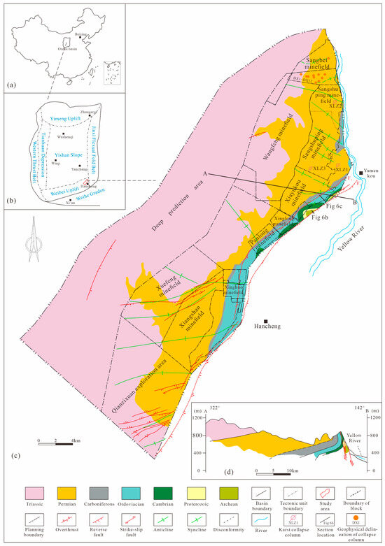
Figure 1.
Geological maps of the study area. (a) Location of Ordos Block. (b) Tectonic divisions of the Ordos Block and location of the study area. (c) Strata, structures in the Hancheng Mining Area. (d) Geological map of cross-section A-B in the Hancheng Mining Area.
This study aims to unravel and gain in-depth insight into the geological conditions for the development and formation–evolution process of karst collapse columns (KCCs) in the Hancheng Mining Area. To do so, it builds on existing research foundations and employs a suite of methods—including field geological observation and structural analysis, thin-section microscopic identification, geochemical analysis, and the reconstruction of paleoenvironments, paleohydrological regimes, and paleogeomorphology. Thus, this study conducts a detailed investigation into the geological conditions governing KCC development in the area. These conditions encompass the material basis for KCC formation (i.e., the development of soluble rocks), the characteristics of tectonic stress, and paleohydrological systems. This research aims to identify the key geological factors controlling KCC development and further construct a multi-stage dynamic evolution model of KCCs by integrating regional geological features. Ultimately, this work provides theoretical support for KCC prediction and hazard mitigation in the context of safe, green, and efficient coal resource extraction in the Hancheng Mining Area, while offering new insights and evidence for exploring the development mechanism of KCCs in North China-type coalfields.
2. Regional Geological Background
The Ordos Block, located in the western part of the North China Craton, is a multi-rotational superposition basin [17]. The basin can be divided into six primary tectonic units: Yimeng Uplift, Weibei Uplift, Jinxi Flexural Fold Belt, Yishan Slope, Tianhuan Depression, and Western Thrust Belt (Figure 1b) [18,19]. The Hancheng Mining Area is located in the eastern part of the Weibei Uplift zone in the southeastern margin of the Ordos Block, which is the convergence zone of the Weibei Uplift and the Jinxi Flexural Fold Belt (Figure 1b), and its tectonic evolution is controlled through the multi-phase activity of the southeastern margin of the basin. From the Middle Cambrian to the Middle Ordovician, with the expansion of the sea intrusion of the whole North China Plate, the whole Ordos Plate, including the Hancheng Mining Area, was mainly a land–surface marine environment, and a set of carbonatite buildups were deposited [20,21]. At the end of the Middle Ordovician, the Proto-Tethyan Ocean Basin in the southern part of the Ordos Plate was subducted and closed under the influence of Caledonian Motion, which resulted in the overall uplift of the whole Ordos Plate. The North China Plate as a whole was uplifted, forming widely distributed unconformable sedimentary sections and weathered crusts [22,23], thus announcing the end of carbonate deposition. During the Late Carboniferous Benxi Period, the Ordos Block underwent regional subsidence and seawater intruded once again, forming a giant basin in North China from the Carboniferous Benxi Period to the Early Permian Taiyuan Period. Then, from the Carboniferous Benxi Stage to the Early Permian Taiyuan Stage, the Ordos Block received coal-bearing deposits from the intersection of land and sea; during the Early Permian Shanxi Stage, seawater gradually withdrew, and a set of land-phase coal-bearing constructions were deposited in the Ordos Block, including the Hancheng Mining Area. In the Late Paleozoic, the Paleo-Asian Ocean subduction in the northern part of the Ordos Block was closed, the Siberian Plate collided with the North China Plate to create mountains, the Paleo-Tethys Basin subduction in the southern Qinling area subsided strongly, and the Ordos Block evolved into an inland basin [24]. During the Indosinian period, with the subduction closure of the Paleo-Tethys Basin and the collision of the South China and North China Plates, the tectonic stress field in the Ordos Block was dominated by the S-N extrusion [25,26]. During the Mesozoic period, under the influence of the regional tectonic movement, the Ordos Block formed a large inland depression-type sedimentary basin, which received the riverine-lake sedimentary rock systems of the Triassic and Cretaceous systems. During the Yanshanian period, affected by the northwestward subduction of the Paleo-Pacific Plate, the paleotectonic stress field of the Ordos Block (including the Hancheng Mining Area) exhibited NW-SE-directed compression. This compression led to the formation of a series of NE-SW-trending compressive structures, which laid the foundation for the current basic tectonic pattern of the Hancheng Mining Area—specifically, a monocline structure with a NE strike and NW dip [27]. Meanwhile, thrust faults represented by the Yumenkou-Wenjialing Thrust Fault (F2) were formed at the southeastern boundary of the mining area [28]. The Apatite Fission Track (AFT) results indicate that the SE margin of the Ordos Block was in a stage of continuous and rapid subsidence and burial during 140–100 Ma, and then began to slowly uplift after reaching the maximum depth of burial in the Cretaceous (approximately 100 Ma) [29,30]. During the Himalayan period, under the far-field effect of the initial collision between the Indo-Australian and Eurasian Plates, as well as the uplift of the Tibet Plateau and the northeastward extrusion of its material, the Ordos Block underwent clockwise rotation. This rotation caused extensional faulting and subsidence in the hinterland of the fold-and-thrust belt between the Qinling orogenic belt and the Ordos Block, leading to the formation of the Weihe graben with a “southern faulting and northern onlapping” geometry [31]. Consequently, the dynamic regime of the southeastern margin of the Ordos Block—including the Hancheng Mining Area—transitioned to an extensional regime [32,33,34]. The extensional-shear Hancheng Major Fault (F1), a boundary fault at the northern margin of the Weihe graben, was formed in the southeastern part of the mining area, which further led to the formation of the Weibei Uplift—a tectonic zone characterized by isostatic warping–uplift in the Weibei region.
3. Material Basis of Karst Development in the Hancheng Mining Area and Its Characteristics
The large-scale karst formed through the dissolution of soluble rocks underneath the coal beds provides space for the collapse of the columns, which is one of the material bases and necessary conditions for the development of KCCs. The soluble rocks underneath the Carboniferous–Diabase coal-bearing rock system in the Hancheng Mining Area are mainly carbonate rocks of the Lower Ordovician Yeli Formation (O1y) and Liangjiashan Formation (O1l) and the Middle Ordovician Majiagou Formation (O2m), and the intensity of karst development in the different strata varies greatly due to the influence of the rock structures, mineral compositions, thicknesses, combinations of petrographic properties, etc. Karst development in the Hancheng Mining Area is mainly caused by the dissolution of coal-bearing rocks.
3.1. Soluble Formation Solubility Analysis
The structure and mineral composition of soluble rock have a significant effect on karst development. Generally, a coarser structure leads to less lime mud matrix and a greater rate of rock dissolution. The dissolution rate of limestone is greater than that of dolomite, but dolomite is prone to brittle fracture, thus developing integrated karstification. At the same time, the characteristics of different lithologic layer groups have a significant impact on karst development. Thicker and purer dolomite or limestone is prone to large-scale karstification to form large-scale karst caves. Limestone and dolomite interbeds with a single-layer thickness greater than 5 m are more likely to develop small caves and dissolved pores in the limestone layer [35].
The Lower Ordovician Yeli Formation (O1y) and Liangjiashan Formation (O1l) in the Hancheng Mining Area are mainly composed of medium-thick dolomite with argillaceous dolomite, rich in argillaceous, chert bands, and siliceous bands or nodules that are not easy to dissolve. The high shale content and rock heterogeneity in this rock–stratigraphy combination hinder the vertical migration of karst water, thus inhibiting the development of large-scale karst. Field investigation found that only a small number of vertical dissolution fissures formed in the middle-thick dolomite layer, which is enough to show that it is difficult to form a large-scale karst cavity in the lower Ordovician in the study area to provide space for the formation of collapse columns. This difference can be reasonably explained with respect to the lithological groups.
The main body of the Middle Ordovician Majiagou Formation (O2m) is a set of thin–medium-thick layers of micrite-fine crystalline dolomite, argillaceous dolomite, and dolomite limestone with mudstone combination, which can be divided into six members from bottom to top (M1, M2…M6) (Figure 2). Owing to variations in lithologic assemblage and bed thickness, its karst development potential exhibits distinct stratigraphic differences. The M1 member consists of thin-bedded argillaceous dolomite deposited in subaqueous landslide deposits. Its strata are characterized by disordered, distorted bedding, high argillaceous content, and minimal karst development. The middle to lower parts of the M2 member are dominated by medium-bedded micritic limestone—a lithology prone to bedding-parallel karst, which manifests as dissolved pores and small karst caves. The upper part of the M2 member transitions from thin- to thick-bedded tuff-bearing fine-crystalline dolomite, interbedded with argillo-micritic fine-grained intraclastic dolomite; this interval has uneven bed thickness and is unfavorable for karst development. Although M3 and M4 are dominated by thick-bedded dolomite, they are interbedded with mudstone or limestone overall. Single mudstone beds are approximately 5 m thick, and karst development is limited by these mudstone interbeds and chert nodules. Field observations reveal the interbedding of multiple dolomite beds with thin karst breccia layers, indicating past bedding-parallel karst development. The M5 member is primarily composed of massive argillo-fine crystalline dolomite, locally containing ooids and fibrous gypsum. This member has low shale content and great thickness (>100 m), commonly referred to as the “100 m Dolomite.” Weathering crusts are locally visible at its top, reflecting long-term weathering and erosion. Under comprehensive karst processes, the dolomite is prone to forming large-scale vertical fractures (via mechanical fracturing), which further develop into fissure-like karst caves. Due to Caledonian tectonic uplift, the lower part of the M6 member was extensively eroded, leaving only local remnants in the northern study area. These remnants are thin-bedded and limited in extent; weathering crusts are visible at their tops, making them unfavorable for large karst cave formation.
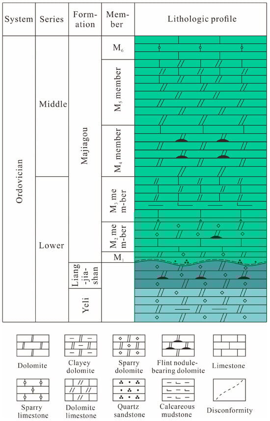
Figure 2.
Columnar diagram of Ordovician strata in the study area.
Based on the above analysis of the main soluble rock strata underlying the coal-bearing sequence in the Hancheng Mining Area, the M5 member is dominated by thick-bedded dolomite, with the characteristics of low shale content, stable thickness, and well-developed vertical fractures—all favorable for large-scale karst development. In contrast, other members are constrained by their lithologic assemblages: they are prone to bedding-parallel karst but not large-scale karst caves. Thus, the M5 member is the most karst-susceptible interval in the Hancheng Mining Area, and the development of karst pores and caves within it provides a favorable material basis for karst-related processes.
3.2. Petrological and Sedimentary Characteristics of Soluble Rocks (M5)
3.2.1. Petrological Characteristics
Typically, the dissolution of carbonate rocks is closely related to their petrological characteristics. Based on detailed observations of cores and field outcrops, as well as identification and analysis of thin rock sections from the M5 member in the Hancheng Mining Area, the dolomites in this member are mainly classified into two major types: granular and crystalline. Among them, granular dolomites are dominated by micritic breccia dolomites. The breccia clasts, ranging from 1 to 2 cm in size, exhibit angular to subangular shapes and are composed of micritic dolomite and silt-sized crystalline dolomite. In contrast, crystalline dolomites are entirely composed of dolomite crystals formed by metasomatism and subsequent recrystallization. According to the size of the dolomite crystals, they can be further divided into micritic (microcrystalline), silt-sized crystalline, and fine-grained crystalline dolomite. Micritic dolomite is the most common type in the study area. Most of its dolomite crystals are smaller than 0.005 mm, showing hypidiomorphic to xenomorphic forms and mostly mosaic textures. A small amount of clay minerals may be present between crystals, occasionally accompanied by terrigenous quartz sand and silt. Dissolution fractures and other fracture types are well-developed (Figure 3a).
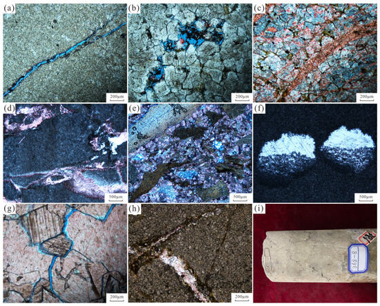
Figure 3.
Petrological characteristics of carbonate rocks of the M5 member in the study area. (a) Micritic dolomite with developed fractures. (b) Fine-crystalline dolomite with developed dolomite intercrystalline pores. (c) Fine-crystalline dolomite with developed intragranular pores. (d) Dissolved brecciated micritic dolomite with calcite veins. The original rock has an aphanitic texture, showing brecciated shape due to dissolution, and the interblocks are filled with calcite. (e) Argillaceous dolomitic brecciated fine-crystalline limestone. The breccia clasts are torn-shaped, highly mixed with argillaceous materials, with uneven sizes and slightly directional arrangement. The intergranular spaces are filled with euhedral calcite and a small amount of residual polycrystalline quartz (brecciated structure). (f) Well micritic dolomite with developed gypsum mold pores (showing a top–bottom structure). (g) Micritic limestone with dense coarse-grained calcite veins and nodules, containing calcite intergranular fractures. (h) Well micritic dolomite with fine vein-like chert and fractures. (i) Stylolites developed in micritic limestone.
3.2.2. Pore Characteristics
Under normal circumstances, secondary pores are widely developed in soluble rock strata under the action of faults and other ruptures. When the structural and dissolution fractures in the secondary pores are interspersed with each other to form a fracture network system or communicate dissolution pores, it is more conducive to the development of karstification, which can further expand the formation of non-fabric-selective super-large dissolution pores, and even caves. Microscope observation of field outcrops found that the pores of the M5 member in the study area are extremely developed, mainly secondary pores. There are fabric-selective intercrystalline pores and moldic pores, as well as non-fabric-selective structural fractures, dissolution fractures, and karst caves, which directly reflect the karst development in the whole layer. Microscopic observation shows that fine-grained dolomite develops intercrystalline pores (Figure 3b), fine-grained dolomite develops intragranular pores (Figure 3c), gypsum film pores develop in micritic dolomite (Figure 3f), and sutures develop in micritic limestone (Figure 3i). The carbonate rocks in the M5 member have been superimposed by multi-stage tectonic movements since the Caledonian tectonic movement. The developed secondary pores such as structural and dissolution fractures provide favorable conditions for the circulation and storage of karst water and further promote the development of karstification.
3.2.3. Types and Characteristics of Sedimentary Microfacies
The Ordovician Majiagou Formation at the southeastern margin of Ordos (including the Hancheng Mining Area) is mainly deposited on land–marine surface terraces, and the Chaoping phase is widely developed [36,37]. Based on the observation and analysis of field outcrops, drill cores, and rock thin sections, the M5 member in the study area can be further divided into three microfacies according to rock associations: tidal flat karst, tidal flat tempestite, and dolomite flat. The tidal flat karst microfacies is mainly developed in the northern part of the Hancheng Mining Area (Figure 4), and the lithology is mainly dominated by dissolution breccia dolomite, which is a breccia-like structure formed by the atmospheric freshwater filtration of the original rock during the depositional period and the modification of the later rock-forming dissolution (Figure 3d). Moreover, the dissolution pores and crevices in between the breccia provide the initial space for the later karst, which makes it easy for fluids to be further dissolved along the boundary of the breccia. The main body of the microphase of the tidal flat tempestite microfacies developed in the middle and southern part of the Hancheng Mining Area (Figure 4), and the lithology is mainly divided into three kinds of microphases. Specifically, as shown in Figure 4, the lithology is mainly dominated by mud-cloudy breccia fine-crystalline tuff, and the voids between breccias formed by wind and waves and the interface between cement and breccia enhance the permeability of rocks and indirectly promote dissolution (Figure 3e), but the mud mixing reduces the purity of the composition, which impedes the dissolution of the rocks to a certain degree. The dolomite flat microfacies is mainly developed in the southern part of the Hancheng Mining Area, with an extremely small area, and the lithology is mainly dominated by mud-crystalline microcrystalline dolomite. The developed paste film pores (gypsum dissolution residue) provide channels for fluid vertical infiltration, indicating a significant top–bottom structure (Figure 3f). Field observations show that the current karst in the Hancheng Mining Area presents a distribution pattern of “strong in the north and relatively weak in the south,” which is highly consistent with the sedimentary microfacies of the M5 member in the area. Moreover, KCCs that have been explored in the entire area are mainly developed within the scope of the tidal flat karst microfacies in the north, indicating that the tidal flat karst microfacies may determine the solubility of rocks to a certain extent.
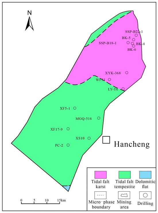
Figure 4.
Lithofacies paleogeographic background map of the 5th member of the Majiagou formation, Ordovician system (O2m5).
3.2.4. Sedimentary Environment Analysis
In general, syngenetic karst mainly occurs in the atmospheric freshwater environment during the sedimentary period. In order to further analyze and understand the sedimentary paleoenvironment of the M5 member in the Hancheng Mining Area, 12 rock samples were collected for geochemical analysis at the State Key Laboratory of Continental Evolution and Early Life of Northwest University in Xi’an, China, using inductively coupled plasma mass spectrometry (ICP-MS). The precision of the instrument is better than 5%, and the relative error between the standard sample result and the recommended value is less than 10%. The analysis results are shown in Table 1.

Table 1.
Trace and rare earth element (ppm) analysis results and some parameters of carbonate rocks in M5 member.
The experimental results show that the total amount of rare earth elements (∑REE) in the rock samples of the M5 member is 16.94 × 10⁻⁶ on average, and most of the samples amount to (10~30) × 10−6, which is in line with the law that the total amount of rare earth elements in carbonate rocks is generally lower than 100 × 10−6. The (La/Yb)N values of the samples range from 0.41 to 1.41, with an average of 0.87, indicating a low degree of fractionation between light and heavy rare earths (Figure 5a). The normalized spider diagram of trace elements in North American shale (Figure 5b) shows that it is relatively enriched in U, Sr, and other elements, and relatively depleted in Rb, Sm, and other elements, indicating that it may be affected by the ‘impurity’ of carbonate rocks and subsequent karstification.
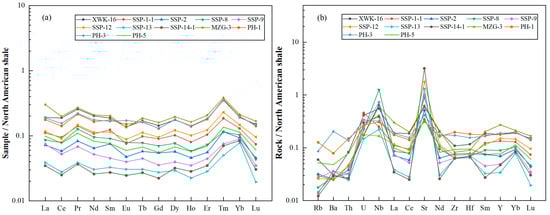
Figure 5.
PASS standardized distribution diagram of rare earth elements of M5 member in Hancheng Mining Area (a) and standardized spider diagram of trace elements in North American shale (b).
Sedimentary facies and paleowater depth can be classified to a certain extent based on Sr content and the Sr/Ba ratio. An Sr/Ba ratio of <1 indicates a freshwater environment (terrigenous sedimentation), while a ratio of >1 indicates a saltwater environment (marine sedimentation) [39,40]. Additionally, the Sr/Ba ratio gradually increases from a continental to marine environment [41]. The Sr/Ba ratios of the carbonate rocks from the M5 member range from 0.45 to 24.14, with an average of 6.84, indicating that it is a shallow-water environment near the shore during deposition.
Generally, in arid environments, Sr enters sedimentary rocks in the form of salts, leading to a relatively high Sr content. Therefore, the Sr/Cu ratio can be used to determine the climatic environment, and an Sr/Cu ratio greater than 10.00 indicates a dry-hot climate [42]. The Sr/Cu ratios of the rock samples from the M5 member in the study area range from 5.12 to 187.95, with an average of 46.59, indicating that the sediments were mainly formed under dry-hot climatic conditions. Meanwhile, studies have shown that Sr content has a certain correlation with the paleowater temperature (Tpaleowater) to some extent, with the specific relationship expressed as Sr = 2578–80.80 Tpaleowater [43]. Based on this relationship, the Tpaleowater in the study area was calculated to be 26.28–31.35 °C, with an average of 30.24 °C, which further verifies the characteristics of the dry-hot paleoclimate to a certain extent.
Under oxidizing conditions, Ce3+ is easily oxidized to Ce4+, which undergoes hydrolysis and is adsorbed by oxide colloids such as Fe and Mn, resulting in precipitation. This leads to significant Ce depletion in seawater. Conversely, Ce enrichment occurs under reducing conditions. Therefore, the Ce element in rare earth elements can reflect the redox conditions of carbonate rocks to a certain extent [44,45]. The δCe values of most samples in the study area range from 0.69 to 0.85, with an average of 0.74, showing a weak negative Ce anomaly. This indicates that the seawater at that time was in an oxidizing environment.
The Cu/Zn ratio can be used as a redox indicator to distinguish sedimentary environments. A relatively low Cu/Zn ratio indicates an oxidizing environment, while a relatively high ratio indicates a reducing environment [46]. The Cu/Zn ratios of the M5 member in the study area range from 0.22 to 0.71, with an average of 0.42. The relatively low values reflect that the carbonate rocks of the M5 member were deposited in an oxidizing environment.
The aforementioned paleoenvironmental analysis indicates that the carbonate rocks of the M5 member in the study area were mainly deposited in a nearshore tidal flat environment characterized by oxidizing conditions, relatively shallow water, and a dry-hot climate. Typically, under long-term dry-hot climatic conditions, seawater evaporates intensely, leading to increased salinity of tidal flat water. The high-salinity environment accelerates the process of dolomite replacing calcite, purifying the rock composition and providing a more reactive material basis for subsequent dissolution. Additionally, the shallow water environment of the nearshore tidal flat exposes sediments to the atmosphere frequently, and the oxidizing conditions significantly alter the chemical properties of pore fluids. In an aerobic environment, the dissolution reaction of dolomite (CaMg(CO3)2) is more likely to proceed in the direction of generating Ca2+ and Mg2+. Moreover, Mg2+ can form stable complexes with oxidized ions (e.g., Fe3+) in water, which further promotes the positive shift in the reaction equilibrium and accelerates rock dissolution. These chemical conditions caused the dolomites of the M5 member to undergo dissolution during the sedimentary period, forming primary dissolved pores and providing initial spaces for later karstification.
4. Structural Geological Conditions and Characteristics of KCC Development
The tectonic action mentioned above is one of the main controlling factors of karst development, especially the regional crustal rise and fall, which has great influence on the vertical development of karst. The development position of the collapse columns exposed in the Hancheng Mining Area is close to the area where the syncline and fault structure are densely developed. This distribution relationship shows that the distribution of KCCs is related to the tectonic movement of the Hancheng Mining Area, to a certain extent. Since the formation of Ordovician soluble rock deposition, this area has experienced multi-stage tectonic action, and the tectonic geological conditions are relatively complex.
4.1. Tectonic Development Characteristics
The tectonic morphology of the Hancheng Mining Area is affected by the large-scale fault at its southeastern boundary. On the whole, it presents a monocline structure with a NE strike and NW dip, which is complicated by folds and faults. The tectonic deformation is intense at the southeastern margin, while relatively weak in the interior, where faults, folds, and joints of relatively small scales are widely developed.
4.1.1. Fault
The faults in the Hancheng Mining Area are predominantly oriented in the NE, NW, and nearly E-W directions (Figure 6a), with most exhibiting the characteristics of normal faults. Among these, faults with a large throw mostly cut through the entire coal-bearing rock series; they are primarily NE-oriented, followed by those trending nearly E-W. Specifically, NE-oriented faults are concentrated in the shallow, deep, and marginal parts of the study area, while nearly E-W-oriented faults are mainly distributed in the southern part of the mining area. The tectonic development of the mining area is largely controlled by two major faults at its southeastern boundary: the Hancheng Major Fault (F1) and the Yumenkou-Wenjialing Fault (F2). F1 is an extensional shear normal fault with basin–mountain boundary attributes, located at the northern margin of the Weihe graben system. Striking NE and dipping SE, it penetrates the entire regional stratigraphy and cuts through the F2 fault from bottom to top. Its formation is closely associated with the development of the Cenozoic Weihe graben system. F2 is a thrust nappe fault that propagates from SE to NW. With an extension of 18.4 km within the mining area, it develops in Ordovician carbonate rocks. Its hanging wall is mainly composed of Archean, Cambrian, and Ordovician strata, whereas the footwall primarily consists of Ordovician, Carboniferous, and Permian coal-bearing rock series. Under the influence of this fault, the coal-bearing strata adjacent to the fault zone have been overturned; meanwhile, the coal-bearing strata across the mining area have undergone tilting and folding, resulting in a general tectonic morphology characterized by uplift in the southeast and subsidence in the northwest of the mining area. The formation of F2 is mainly linked to the regional SE-NW-directed compression during the Yanshanian period, which also established the basic tectonic framework of the mining area. Within the mining area, F1 and F2 share the same strike, and F1 cuts through F2. Together, these two faults govern the development pattern of the mining area’s fault system and exert a significant impact on the integrity of both Ordovician carbonate rocks and coal-bearing strata. Faults of various orientations in the mining area have not only disrupted the integrity of the coal-bearing strata but also enhanced the connectivity of karst water, thereby providing favorable conditions for karst development and the collapse of the overlying coal-bearing strata.
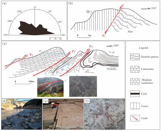
Figure 6.
Structural development characteristics of Hancheng Mining Area. (a) Rose diagram of fault strike. (b) Maozigou gully mouth F1 fault sketch map. (c) Structural deformation sketch map of Shangyukougou F2 fault. (d,e) Conjugate joint diagram of Ordovician development at the mouth of the Chisel River into the Yellow River. (f) Checkerboard joints in Sangbei minefield. Note: Section locations of (b,c) are marked in Figure 1.
4.1.2. Fold
The folds in the Hancheng Mining Area are relatively developed. In addition to the southeast boundary affected by F2, the footwall coal measures strata develop large, inverted folds with NE and SE trends (Figure 6c). Many small folds are also developed in the mining area, and the axial direction of the folds is near E-W and NW. Among them, the northern part of the Hancheng Mining Area is dominated by NW, and the southern part is dominated by near E-W. The NW-trending folds are mostly linear, and the E-W-trending fold axis is generally deflected to NE [47], reflecting the characteristics of later structural superposition and transformation. The fold axis in the southern area is mainly in the near E-W direction. According to the characteristics of the regional stress field, the near-E-W-trending folds may be the result of the north–south compression in the Indosinian period, while the NW-trending folds mostly show a sharp angle with the boundary faults, and the axial direction of the E-W-trending folds is close to the boundary faults and turns to NE, indicating that the two are genetically closely related to the development of the boundary faults.
During fold formation, the turning end of the fold is subjected to stress, and more tensile fractures (joints) are often developed, resulting in a much higher degree of rock fragmentation than that of the wing. The densely developed fractures constitute the dominant channel for the vertical migration of karst water, which often promotes the dissolution of thick dolomite. The proved collapse columns in Hancheng Mining Area are located at the turning end of syncline, indicating that their formation is closely related to the turning end’s structural development.
4.1.3. Joints
Within the mining area, joints are predominantly developed with orientations of NW, NE, nearly E-W, and nearly N-S, and exhibit poor infilling characteristics. Tension gashes (en echelon joints) are locally observed. Among these, NW and NE striking joints are the most extensively developed, displaying a “chessboard-style” distribution. The conjugate joint system formed by these two joint sets yields a restored stress field dominated by nearly N-S directed compressive stress, which is consistent with the regional N-S compressive regime during the Indosinian period and indicates that this set of joints was generated in this period. The shear fracture planes formed during this period evolved into weak planes within the strata. Under the influence of the regional paleotectonic stress field in subsequent stages, these shear fracture planes frequently propagated into faults [48,49]. For the conjugate joint system composed of nearly E-W and nearly N-S striking joints, the restored stress field exhibits the characteristics of the regional NW-SE-directed compressive stress field during the Yanshanian period, suggesting their formation in the Yanshanian period. The intersecting zones of joints with different orientations in the mining area are conducive to the connectivity of the hydraulic network and constitute favorable domains for karst development.
4.2. Structural Evolution and Its Regional Lifting Characteristics
Since the formation of the Ordovician tidal flat facies carbonate rock formation in the Hancheng Mining Area, the main body has experienced the tectonic evolution process of the Caledonian, Indosinian, Yanshanian and Himalayan periods, and a certain degree of crustal uplift and subsidence has occurred, which provides a strong condition for the vertical development of karst.
4.2.1. The Overall Uplift Denudation Stage of the Caledonian Period
During the Late Ordovician–Silurian period, affected by the Caledonian Orogeny, the Hancheng Mining Area underwent overall uplift, which terminated the sedimentation of carbonate rocks. Additionally, the stratigraphic sedimentation from the Late Ordovician to the Early Carboniferous is absent in this area, resulting in an unconformable contact between the Upper and Lower Paleozoic Erathems. This geological setting formed a regional weathering crust and served as the sedimentary basement for the Late Paleozoic coal-bearing strata. Influenced by the Archean crystalline basement, the tectonic activities during this period were dominated by crustal uplift in the Hancheng Mining Area, with relatively underdeveloped horizontal movement. Specifically, the tectonic deformation within the Early Paleozoic strata of the Hancheng Mining Area was relatively weak during this stage [50]. Meanwhile, the crustal uplift during this period exposed the carbonate rocks deposited in the Early–Middle Ordovician to the surface for long-term weathering and erosion. Modified by the leaching and dissolution of atmospheric precipitation and surface runoff, a certain degree of paleokarst developed within the weathering crust.
4.2.2. The Development Stage of Fold and Fault Structure Under Continuous Subsidence and North–South Compression System in Indosinian Period
From the Middle Carboniferous to the Early Triassic, the regional subsidence rate increased from small to large, and the Ordos Block, including the Hancheng Mining Area, fell again to accept the deposition, and a set of coal-bearing rock series was deposited in the study area. From the Middle Permian to the Middle Triassic, the subsidence rate suddenly accelerated, and the Lower Shihezi Formation–Liujiagou Formation was deposited in the study area, and the burial depth of the coal-bearing strata continued to increase. At the same time, in the Late Indosinian period, the Hancheng Mining Area was affected by the collision orogeny between the north and south continents. Under the action of nearly north–south compression, a large number of nearly E-W-trending longitudinal folds and reverse faults were formed in the coal-bearing rock series and its overlying strata, as well as the plane conjugate shear joint system composed of NE- and NW-trending shear fracture surfaces.
4.2.3. The Thrust Deformation and Rapid Rise and Fall Stage Under the Action of the SE-NW Extrusion System in the Yanshanian Period
From the Middle and Late Triassic to the Early Cretaceous, the subsidence rate in the study area showed a trend of increasing from west to south. The thermal history simulation results of AFT show that the Triassic Yanchang Formation in the Hancheng area has undergone a slow burial process since deposition [29]. The period of 140~100 Ma was a continuous burial stage, and the formation temperature gradually increases. At about 100 Ma, the formation temperature reaches the peak, that is, the deepest burial. Thus, it is inferred that the regional subsidence stage may continue to the early Early Cretaceous (100 Ma), and the crustal subsidence rate has a gradual acceleration trend, resulting in the weakening of karstification due to the deep burial of Ordovician carbonate rocks. However, at present, there are few sedimentary strata in the Middle and Late Mesozoic in the study area. The ancient tectonic stress field of the Hancheng Mining Area in the Yanshanian period is characterized by the compression from SE to NW [25], which leads to the uplift of the southeast and the subsidence of the northwest of the mining area, forming a monoclinic structure with an NE trend and NW tendency. Based on some NE-trending shear surface structures formed in the Indosinian epoch, the compression–torsional reverse faults (such as F2) were further developed, and the plane conjugate shear joint system composed of nearly east–west and nearly north–south shear surfaces was also formed.
4.2.4. The Stage of Fault Development and Differential Uplift Under the Extensional Regime During the Himalayan Period
During the Himalayan period, due to the long-range effect of the initial collision of the Indo-Australian and Eurasian plates and the uplift of the Tibet Plateau and its material extrusion to the NE direction, the Ordos Block rotated clockwise, which also changed the dynamic system of the southern margin of the Ordos Block from the Mesozoic compression to the extensional system [32,33,34]. The regional tectonic evolution of the Hancheng Mining Area, which is located in the southeastern margin of the Ordos Block, also enters the extensional system. The tectonic stress field is characterized by SE-trending extension, and a large number of extensional structures appear. The F1 and a large number of small normal faults exposed during the mining of coal resources in the mining area are the products of this period [51]. At the same time, since the late Early Cretaceous, the Hancheng Mining Area began to enter the uneven uplift stage. The simulation results of AFT thermal history show that the uplift began slowly at about 100~40 Ma, and the uplift rate of 40~30 Ma samples was relatively accelerated [52,53]. This crustal uplift movement also resulted in the general lack of Middle–Upper Triassic, Jurassic, Cretaceous, and Paleogene strata in the Hancheng Mining Area. In general, the late extensional structure can make the karst caves formed by the early karstification gradually destabilize and cause gravity collapse.
5. Ancient Hydrogeological Conditions and Karst Development Characteristics in Hancheng Mining Area
Ancient hydrogeological conditions have an important control effect on karst development. In particular, after the Ordovician deposition, the karst development characteristics formed through long-term exposure to the weathering and denudation of the surface control led to the development of subsequent karstification to a certain extent.
5.1. Ancient Hydrogeological Conditions
Although hydrogeological conditions such as the paleoflow field during the paleokarst development period are relatively difficult to reconstruct, paleotopography and paleogeomorphology can indirectly reflect the paleoflow field to a certain extent. In this study, the sequence stratigraphy method [54] was used to select the top surface of the No. 11 coal seam—deposited in the Late Carboniferous–Early Permian and closest to the top surface of the Ordovician System—as a regional isochronous surface to reconstruct the paleogeomorphic morphology of the Ordovician top surface during the corresponding period (Figure 7). The results show that the overall topography of the Hancheng Mining Area is high in the northwest and low in the southeast, with significant local topographic relief. The highest point is located at the boundary between the Xiangshan Coalfield and the Xuefeng Coalfield, while the lowest point is in the northern part of the Sangshuping Coalfield in the northeastern mining area, with a maximum depression depth of 66 m. Overall, an erosion groove extending in the NE-SW direction formed in the northern part of the mining area, showing a funnel-shaped depression at its northeasternmost end. This erosion groove extends from north to south and evolves into a karst shallow valley, which further transitions southward to the karst platform in the southern mining area. On both sides of the erosion groove, the terrain transitions northwestward and southeastward into a karst platform and karst highland, respectively. This set of paleogeomorphic features constitutes a network composed of surface water-collecting grooves and seasonal rivers, further indicating that when the Ordovician carbonate rocks were exposed at the surface, a surface water runoff zone formed in the northeastern part of the study area. Surface water flowed along the NE-SW-trending runoff zone into the northern karst depressions (sinkholes), forming a “recharge area–runoff area–discharge area” system in the paleohydrological regime. Meanwhile, water seeped into deep strata through the joint–fracture system developed on both sides of the grooves, enabling the grooves and the high-permeability dolomites of the M5 member to form a ternary linkage system of “water collection–water conduction–dissolution.” This paleoflow field characteristic continuously expanded and deepened the scope of the karst depressions in the northern Sangshuping area. Currently, all identified sinkholes are mainly developed in the karst depression area of northern Sangshuping, indicating that this topographic and geomorphic feature exerts a significant controlling effect on karst development.
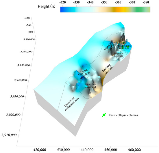
Figure 7.
Reconstruction of the paleokarst geomorphology on the top Ordovician surface (with the Late Carboniferous–Early Permian 11# coal seam as a regional isochronous surface).
5.2. Karst Development Time and Its Type
The direct floor of coal measure strata in Hancheng mining area is Ordovician soluble rock. After the Ordovician, it experienced four major tectonic movements: the Caledonian, Indosinian, Yanshanian, and Himalayan. This multi-stage tectonic movement transformation led to the superposition and combination of karst types, and the changes are diverse. Based on microscopic thin-section analysis, the structural development process, and the ancient fluency characteristics of borehole core samples and outcrop samples in Hancheng Mining Area, the karstification in Hancheng Mining Area mainly experienced three periods: syngenetic karst development, weathering crust karst development, and buried karst development.
5.2.1. Syngenetic Karst Development Periods
Syngenetic karst mainly occurs in the atmospheric freshwater environment during a sedimentary period. Carbonate sediments often result from the deposition rate being greater than that of sea level rise, or from the decline in sea level and exposure to the water surface. Atmospheric water plays a role in karst development; identification signs of syngenetic karst mainly include intergranular dissolved pores, intragranular dissolved pores, gypsum film pores, etc. A large number of gypsum film pores (Figure 3f) have developed in the micritic dolomite of the M5 member in the study area. The seepage silt filling the lower part of the dissolved pore is the product of the downward seepage of surface mud and silt particles carried by atmospheric precipitation along the dissolved pore. It belongs to the top and bottom structure of the cloud flat microfacies in the tidal flat environment, which directly confirms the occurrence of syngenetic karstification.
5.2.2. Weathering Crust Karst Development Periods
Weathering crust karstification, also known as supergene karstification, refers to the significant decline in sea level caused by tectonic movement, the large-scale exposure of soluble rocks, and the dissolution caused by atmospheric water leaching. Core and thin-section observation of the M5 member in the Hancheng Mining Area reveals that the calcite in the pores of fine-grained dolomite is banded and arranged in one direction, which is consistent with the boundary of rock particles and the crack trend (Figure 3c), indicating that it is obviously affected by atmospheric water leakage and dissolution. The results of paleogeomorphology restoration show that there are karst landforms such as sinkholes, dissolution depressions, ancient rivers, peak clusters, and dissolution plains in the weathering crust at the top of the Ordovician after the weathering crust karst development stage, which fully proves the stage’s existence. At the same time, in the ditches and flame ditches in the study area and its adjacent areas, there are still karst funnels (or karst caves, shafts) and remnants developed in M5 member, with a range of about 20 m and a depth of 10~20 m. The interior is filled with typical products of weathering crust such as bauxite mudstone with obvious bedding and Shanxi-style iron ore, which fully proves the existence of weathering crust karstification [55].
This also indicates that after the Caledonian movement in the Hancheng Mining Area, the Ordovician carbonate rocks were subjected to weathering and denudation for nearly 132 Ma. During this long process of weathering and denudation, the leaching and dissolution of atmospheric precipitation and surface runoff continuously transformed the fine-grained limestone or dolomitic limestone, forming the weathering crust paleokarst that is now widely developed. The karstification of the weathering crust provided very favorable conditions for the development of the later collapse columns.
5.2.3. Buried Karst Development Periods
After undergoing a long-term weathering crust karst development stage, the carbonate rocks of the M5 member in the Hancheng Mining Area began to receive sediments from the Benxi Formation of the Late Carboniferous, entering a deep burial environment. Changes in the burial environment led to changes in temperature and pressure conditions, which not only control the pore development of rocks and hydrothermal mineralization but also affect the occurrence of karstification. Typically, under deep burial conditions, karstification becomes more complex when modifying existing karst phenomena, making it difficult to identify. Its identification markers are mainly the pores in carbonate rocks and the fillings within these pores. Generally, in a deep burial environment, dolomite crystals grow and coalesce to form relatively coarse grains (grain size > 0.1 mm), and intercrystalline pores are generated between crystals due to uneven growth or fluid dissolution. In the later stage, when deep CO2-rich fluids infiltrate, these intercrystalline pores are further dissolved and expanded into intercrystalline dissolved pores [56]. Additionally, the dissolved and expanded pressure solution seams formed through the dissolution and expansion of early stylolites, along with related dissolution structures, are also products of the continuous action of fluids along weak zones in the burial environment [57]. In the carbonate rocks of the M5 member in the Hancheng Mining Area, there are relatively large intercrystalline pores or intercrystalline dissolved pores between the densely arranged medium-coarse crystalline dolomite crystals. This indicates that after compaction under deep burial conditions, the rocks were further dissolved by deep fluids (Figure 3g). Moreover, chert fillings are observed in the fractures, suggesting the occurrence of deep siliceous hydrothermal activity (Figure 3h). Meanwhile, microscopic thin-section identification shows that further dissolution and expansion occurred along the early-formed stylolites, forming dissolved and expanded pressure solution seams, dissolved micropores, or open fractures that were not completely filled (Figure 3i). These observations indicate that under continuous sedimentation, the M5 member was gradually deeply buried, leading the carbonate rocks to transition into the development stage of burial karstification.
Typically, the development of burial karst is directly influenced by burial depth and temperature–pressure conditions. Combined with the aforementioned crustal uplift and subsidence characteristics of the study area, the burial karstification in the Hancheng Mining Area mainly consists of two sub-stages:
- (1)
- Middle Carboniferous–Early Cretaceous: Karst Weakening and Development Stage
Against the background of burial diagenetic fluids, the increase in temperature with deepening burial depth leads to a decrease in the burial dissolution amount of carbonate rocks [58]. During this period, the continuous crustal subsidence of the study area allowed sediment accumulation [59]. As the sediment thickness increased, the burial depth increased correspondingly, leading to a gradual rise in formation temperature and increase in pressure. This resulted in weakened dissolution and enhanced diagenesis. When the soluble rock layers of the M5 member were buried to a certain depth—below the erosion base level—the hydrodynamic conditions weakened, and karstification attenuated. AFT thermal history simulation results show that by 100 Ma, the burial depth of the Ordovician strata in the Hancheng Mining Area reached its maximum [29], with an estimated burial depth of at least 1680 m, and karstification basically ceased.
- (2)
- Late Early Cretaceous: Karst Rapid Development and Reconstruction Stage
In the late Early Cretaceous, the study area was affected by regional tectonic activities: the crust began to uplift at 100 Ma, accompanied by the formation of numerous compressive structures. Due to this crustal uplift, the temperature–pressure conditions of the carbonate rocks in M5 member changed, and karstification resumed. From 40 Ma to 30 Ma, the study area underwent rapid uplift [29], bringing the strata into a shallow-burial karst environment. Vertical karstification expanded, and existing karst features were further developed and enlarged, providing collapse spaces for the later formation of sinkholes through the collapse and filling of the overlying coal-bearing strata.
6. Discussion on the Development Process and Mechanism of KCCs
This study has analyzed the main controlling factors in the Hancheng Mining Area, such as the development characteristics of soluble rock, paleohydrogeological conditions, and tectonic evolution, alongside the types and characteristics of karst development. Based on this analysis, this section comprehensively discusses and constructs the formation process of KCCs in the Hancheng Mining Area, as well as reveals their formation mechanism. The formation process can be divided into the following stages.
6.1. Ordovician Soluble Rock and Syngenetic Period and Weathering Crust Karst Formation Stage
6.1.1. Ordovician Carbonate Deposition and Syngenetic Karst Development Stage
During the Cambrian–Middle Ordovician, the southeastern margin of the Ordos Block, where the Hancheng Mining Area is located, is below sea level as a whole and dominated by epicontinental marine deposits. In the Ordovician, a set of stable and continuous carbonate rock formations with a high thickness and large sheet-like distribution was formed. In particular, the thick dolomite (commonly known as the 100 m dolomite section) formed by the M5 member became the core layer of karst development due to its dry and hot climate, oxidation, high water temperature, and shallow-water environment. The coastal tidal flat micro-phase paleoenvironment provides excellent conditions for karst development in the same period and also lays a good material foundation for subsequent karst development.
6.1.2. Formation Stage of Weathering Crust Paleokarst
During the Late Ordovician–Silurian, influenced by the Caledonian movement, the Ordos Block uplifted as a whole, including the Hancheng Mining Area. While this ended the marine sedimentary history of the Early Paleozoic epicontinental sea environment, the block suffered from long-term weathering and denudation at the same time. It was not until the Middle Carboniferous that it gradually began to accept deposition, with a time of up to 132 Ma, resulting in the absence of Upper Ordovician, Silurian, Devonian, and Lower Carboniferous in the entire North China region, including the Hancheng Mining Area. The strong uplift and long denudation make the Ordovician carbonate rocks exposed to the surface, and the leaching and dissolution of fine-grained dolomite by atmospheric freshwater are widely developed. The paleogeomorphology of the Ordovician top surface shows that the erosion grooves distributed in the northeast–southwest direction form a network of surface catchment grooves and seasonal rivers, which provides a convergence area and drainage channel for karst water, and finally flows into the karst depression in the north, driving deep dissolution to form fractured karst caves. At the same time, the crustal lifting movement provides a dynamic effect on the paleokarst in the study area, which runs through the whole karstification process from the Late Caledonian to the Early and Middle Hercynian, forming different scales of karst landforms and karst caves (Figure 8a). According to the depth of secondary pyrite development related to the pressure release of overlying strata, it is inferred that the depth of paleokarst advancement of weathering crust in this period is about 150 m.
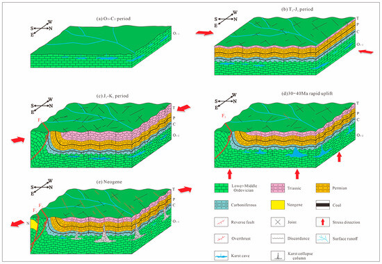
Figure 8.
Development process and formation mechanism of KCCs in Hancheng Mining Area. (a) Deposition of Ordovician soluble rocks and formation of paleokarst in weathering crust. (b) Diagram of stopped karst development in Hancheng Mining Area in Late Indosinian (T3-J1). (c) Diagram of structural pattern transformation in Hancheng Mining Area. (d) Diagram of karst vertical development under rapid crustal uplift. (e) Diagram of collapse column formed by karst cave collapse under extension.
6.2. The Stage of Karst Weakening or Basically Stopping Development in the Indosinian Period (T3-J1)
From the Late Carboniferous of the Paleozoic to the end of the Middle Triassic of the Mesozoic is the overall subsidence stage of the area where the Hancheng Mining Area is located. Since the Late Carboniferous–Early Permian Taiyuan Formation (C2-P1t) began to deposit, the stage has been converted into marine–terrigenous coal-bearing deposits. In the Middle Permian Shanxi Formation (P1s), it became a large continental coal-bearing inland basin environment, and the formation of each group of strata was continuously deposited and integrated. With the deposition of overlying coal-bearing strata, the buried depth of Ordovician carbonate increases. According to the thickness of the overlying strata and Yanchang Formation, the buried depth of the Ordovician is at least 1680 m. The deep burial environment slows or even stops the dissolution of dolomite in the M5 member and maintains the karst results before the Middle Carboniferous.
During the Indosinian period, due to the collision and orogeny of the north and south continents in China, under the action of the north–south direction compressive stress field in the Hancheng Mining Area, the coal-bearing rock series and its overlying strata formed a rare vertical bending fold and a nearly east–west trending reverse fault in the study area. During this period, a plane conjugate shear joint system composed of NE- and NW-trending shear fracture surfaces also formed. These shear fracture surfaces became vulnerable surfaces in the strata of the study area. Under the action of the later regional paleotectonic stress field, the shear fracture surfaces often developed into faults. However, due to the relatively deep burial depth of the Ordovician carbonate rocks and the lack of karst development, the structure of this period has not yet had a great impact on the formation of karst in this period, and there are more are vulnerable surfaces, such as joint faults formed in the overlying strata of the Ordovician carbonate rocks (Figure 8b).
6.3. Transformation Stage of Karst Development Pattern in Late Yanshanian Period (J3-K1)
The Jurassic–Early Cretaceous is the most important tectonic deformation period for the Hancheng Mining Area; it determines the structural pattern and basic form of the whole area. During this period, the paleotectonic stress field in the study area was transformed into NW-SE compression, forming a large NE-SW-trending F2 reverse fault affecting the boundary of the mining area, which further led to the uplift of the southeast and the subsidence of the northwest of the mining area, especially the Ordovician carbonate in the southeast. During this period, the NE-trending folds formed in the northern part of the mining area overlapped with the nearly east–west folds in the Indosinian period, which made the cracks in the steeply dipping strata develop intensively and further promoted the vertical development of karst. At the same time, a plane conjugate shear joint system composed of nearly east–west and nearly north–south shear planes formed in this period, which not only broke the coal measures but also enhanced the connectivity of karst water channels (Figure 8c).
As the largest thrust fault in the study area, the F2 fault not only transforms the strata distribution in the mining area but also acts as a compressive or compressive–torsional structural plane that blocks the migration of karst water and forms a karst water migration model with large differences on both sides, thus controlling the development pattern of karst (Figure 8c). In addition, the ancient ground temperature in the Hancheng Mining Area increased continuously due to sedimentary burial during this period [29], which changed the temperature and pressure environment under deep burial conditions and created conditions for further development of hydrothermal dolomite and karst.
6.4. Late Cretaceous–Eocene Karst Vertical Development Formation Stage
The AFT thermal history simulation results of the Cambrian–Triassic strata in the Hancheng Mining Area show that the entire area began to slowly uplift at about 100~60 Ma, at a relatively accelerated rate of 60~40 Ma samples. The overall uplift has been relatively rapid since 33 Ma, and rapid since 5 Ma. The erosion rate during the entire uplift period can reach 68 m/Ma, and the amount of erosion above the Yanchang Formation is above 1000 m [60]. This uplift extends from east to west and from north to south, and its range increases rapidly from west to east. As a result, the Middle–Upper Triassic, Jurassic, Cretaceous, and Paleogene strata in the Hancheng Mining Area are generally missing.
The Ordovician carbonate rocks in the southeastern part of the Hancheng Mining Area, which were uplifted near-surface under the action of Yanshanian thrust tectonics, were exposed to the surface after denudation, and karst was further developed through groundwater recharge via rainfall. The thick dolomite, multi-order structural features and strong groundwater dynamic field of the M5 member make the karst caves and karst fissures widely developed in this area. The fractures or faults formed under the tectonic stress of the Indosinian and Yanshanian periods are well developed and have strong extensibility, which makes the upper and lower hydraulic connectivity good, resulting in the development of high-angle fractures of karst fractures along faults or fracture intersections in different directions. With the uplift of the crust, the valley is deeply cut, the discharge conditions are good, and the karst is rapidly developed vertically or expanded into karst caves (Figure 8d).
In addition, the superimposed folds formed in the Yanshanian and Indosinian periods, especially the dolomite of the M5 member at the turning point of the syncline, are pulled, and the brittle rock is deformed, gradually forming small fissures and large fissures. The karst water develops along the fissures, and it is easy to form large caves. In short, the karst fissures, caves, and pores are widely distributed in the dolomite construction of the M5 member in the Hancheng Mining Area, forming a dissolution network of karst channels dominated by dissolution fissures.
6.5. Formation Stage of Neogene Collapse Column
In the Cenozoic Eocene, the uplift of the Tibet Plateau and the extrusion of its material in the NE direction resulted in the extension and rifting of the trailing edge of the fold–thrust belt between the Qinling and Ordos Block, forming the Weihe graben with the south fault and the north super [61]. As part of the northern segment of the Weihe Graben System, the Hancheng Mining Area has also entered an extensional tectonic regime. Its tectonic stress field is characterized by SE-directed tension, which has given rise to extensive extensional structures. Within the weak zone where the reverse fault F2 developed, a transtensional normal fault F1 was formed, possessing the attribute of a basin–mountain boundary. Field observations confirming that fault F1 developed along fault F2 further validate this understanding (Figure 6c). At the same time, the tensile tectonic stress field has affected the faults and joints formed in the previous two periods, so that most of the compressive tectonic belts have undergone different degrees of tensile fractures, resulting in a series of normal faults with different strikes, and these extensional faults have destroyed the coal measures and their basements. The more capable strata, through the destruction of the upper closed rock layer at the upper end of the fold turning point of the syncline, resulting in the collapse of the previously formed karst cavity under gravity and other factors, finally formed the KCCs of the Hancheng Mining Area (Figure 8e).
7. Conclusions
This study presented a systematic investigation into the evolutionary processes of karst collapse columns (KCCs) in the Hancheng Mining Area. Drawing on existing data analyses, field geological surveys, laboratory experiments, and comprehensive synthesis, this study explicitly identified the key controlling factors, evolutionary stages, and underlying regularities governing KCC development. The specific conclusions are outlined as follows:
- (1)
- The development of KCCs in the study area is based on soluble rocks, among which the fifth member of the Majiagou Formation (M5) serves as the favorable horizon. This horizon exhibits not only low argillaceous content, stable thickness, and well-developed vertical fractures but also domination by thick-bedded massive dolomite in lithology with relatively well-developed secondary pores. Meanwhile, the nearshore tidal flat sedimentary setting—characterized by a dry-hot climate, oxidative environment, relatively high water temperature, and shallow water depth—laid the foundation for early karstification. Furthermore, the spatial distribution and development intensity of tidal flat karst microfacies further controlled the formation locations of KCCs.
- (2)
- Since the Caledonian period, multiple phases of tectonic activities in the study area have generated structures such as faults, folds, joints, and their combinations, coupled with multi-stage crustal uplift and subsidence movements. These tectonic elements together provide favorable tectono-geological conditions for karst development. In particular, the extensional structures formed during the Cenozoic era act as the dominant factor triggering karst collapse. Meanwhile, the development of NE-SW-trending erosional grooves has, to a certain extent, controlled the formation locations of KCCs.
- (3)
- The development process of karst collapse columns (KCCs) in the Hancheng Mining Area can be divided into five stages: During the Ordovician Period, soluble rocks were first formed, accompanied by the development of karst in their weathering crusts. The Indosinian period saw stagnation in karst development. The Late Yanshanian period witnessed the reconstruction of the karst development pattern. From the Late Cretaceous to the Eocene, karst developed vertically and gradually took shape. Finally, KCCs were fully formed in the Neogene period.
- (4)
- Understanding of the key geological controlling factors and multi-stage evolution of karst collapse columns (KCCs) provides theoretical guidance for the prediction and prevention of sudden water hazards induced by KCCs in the Hancheng Mining Area. To a certain extent, it also offers new insights and evidence for exploring the development mechanism of KCCs in North China-type coalfields. In practical mining operations, monitoring areas with paleogeomorphic valleys, syncline hinge zones, and developed extensional faults should be prioritized. Notably, the number of actually exposed KCCs in this study is relatively limited. It is, therefore, recommended that, as exploration and mining activities advance, our current understanding be refined further based on additional field data. This refinement holds direct and significant practical guiding value for ensuring the safe, green, and efficient extraction of coal resources in the Hancheng Mining Area.
Author Contributions
Conceptualization, Y.C. and X.Y.; data curation, Y.C.; methodology, Y.C. and G.D.; writing—original draft, Y.C. and X.Y.; writing—review and editing, Y.C., X.Y., and G.D.; supervision, Y.C.; formal analysis, X.Y.; investigation, H.Z., G.D., S.L., and W.Y. All authors have read and agreed to the published version of the manuscript.
Funding
This research was funded by the Science and Technology Research Program Project of Shaanxi Coal and Chemical Industry Group Co., Ltd. (Grant No. 2020SMHKJ-B-J-19).
Data Availability Statement
The data in this study have been explained in the article. For detailed data, please contact the corresponding author or the second author.
Acknowledgments
We are thankful to anonymous reviewers for their constructive comments, which significantly improved the manuscript.
Conflicts of Interest
The authors declare that this study received funding from the Science and Technology Research Program Project of Shaanxi Coal and Chemical Industry Group Co., Ltd. (Grant No. 2020SMHKJ-B-J-19). The funder had the following involvement with the study: participation in the investigation and the decision to submit it for publication. Author Shoutao Luo was emlopyed by the company Shaanxi Shanmei Hancheng Mining Co., Ltd. The remaining authors declare that the research was conducted in the absence of any commercial or financial relationships that could be construed as a potential conflict of interest.
References
- Yin, S.X.; Lian, H.Q.; Liu, D.M.; Yin, H.C. 70 years of investigation on Karst collapse column in North China Coalfield: Cause of origin, mechanism and prevention. Coal Sci. Technol. 2019, 47, 1–29. [Google Scholar]
- Cao, Z.; Zhang, S.; Li, Z.; Du, F.; Huang, C.; Wang, W. Numerical research on disastrous mechanism of seepage instability of karst collapse column considering variable mass effect. Sci. Rep. 2024, 14, 13900. [Google Scholar] [CrossRef]
- Qian, Z.W.; Lu, C.J.; Gong, Q.L.; Wu, X.S.; Wang, B.Z. Mechanism and application of high pressure grouting in karst collapse column with vein-like water channel. Coal Sci. Technol. 2024, 53, 292–303. [Google Scholar]
- Zhao, J.G.; Wang, J.W.; Yang, G.F.; Guo, M.T. Pillar wall angles of karst collapse pillars in the Xishan coalfield: Characteristics and implications. Coal Geol. Explor. 2024, 52, 23–30. [Google Scholar]
- Zhao, J.G.; Guo, M.T. Discover and formation time of karst collapse pillar in Laomaling, Pingshun County. J. China Coal Soc. 2014, 39, 1716–1724. [Google Scholar]
- Yang, G.F.; Dou, W.W.; Li, W.L. Study on Development Degree of Collapse Column in Changping Mine and Major Controlling Factors for Its Formation. Saf. Coal Mines 2017, 48, 43–46. [Google Scholar]
- Chang, Y.Q. Development Characteristics and Main Control Factors of Karst Collapse Column in Kailuan Fangezhuang Mine Field. Coal Eng. 2019, 51, 76–79. [Google Scholar]
- Zhang, H.T.; Xu, G.Q.; Zhan, H.B.; Zheng, J.B.; Wang, M.H.; Liu, M.C.; Pan, S.Q.; Wang, N. Formation mechanisms of paleokarst and karst collapse columns of the Middle Cambrian-Lower Ordovician carbonates in Huainan coalfield, Northern China. J. Hydrol. 2021, 601, 126634. [Google Scholar] [CrossRef]
- Yin, S.X.; Wu, Q.; Wang, S.X. Water-Bearing Characteristics and Hydro-geological Models of Karstic Collapse Columns in North China. Chin. J. Rock. Mech. Eng. 2005, 24, 77–82. [Google Scholar]
- Yin, S.X.; Xu, B.; Liu, D.M.; Xu, H. Study on location prediction of paleo-karst sinkholes in Northern China Coalfields. Coal Sci. Technol. 2016, 44, 172–177. [Google Scholar]
- Zhao, J.G.; Guo, M.T. The interlayer structures and the karst collapse pillars style of the coal measure strata in Dayaotou village, Eastern Mountain, Taiyuan. J. China Coal Soc. 2013, 38, 1999–2006. [Google Scholar]
- Niu, L.; Wu, Q.; Li, B. Classification of Karst Collapse Columns in North China coalfields based on the generalized model of inside structure of the columns. Coal Geol. Explor. 2015, 43, 56–60. [Google Scholar]
- Gui, H.; Xu, J.P.; Zhang, D. Relationship between hydraulic conductivity of karst collapse column and its surrounding lithology. Environ. Earth Sci. 2017, 76, 215. [Google Scholar] [CrossRef]
- Gui, H.; Yang, Z.B.; Han, X.X. Study on reason for differences of hydraulic conductivity of karst collapse columns in Wanbei Mining Area. Coal Sci. Technol. 2017, 45, 165–169. [Google Scholar]
- Wei, Y.Y.; Sun, S.L. Comprehensive critical mechanical model of covered karst collapse under the effects of positive and negative pressure. Bull. Eng. Geol. Environ. 2018, 77, 177–190. [Google Scholar]
- Xu, G.Q.; Zhang, H.T.; Zhou, J.S.; Li, X.; Wang, M.H.; Liu, M.C. Study and prospect of karst collapse columns and their water inrush in the coalfield of North China. Carsol. Sin. 2022, 41, 259–275. [Google Scholar]
- Liu, X.; Han, W.; Zhang, Q.; Li, Y.G.; Johnson, L.; Ma, Y.; Li, W.H. Sedimentary and geochronological studies on tuff levels from Triassic strata in the Nanzhao Basin, North Qinling Orogenic Belt, and their geological significance. Geol. J. 2021, 56, 1531–1548. [Google Scholar] [CrossRef]
- Li, W.H.; Chen, Q.; Li, Z.C.; Wang, R.G.; Wang, Y.; Ma, Y. Lithofacies palaeogeography of the Early Paleozoic in Ordos area. J. Palaeogeogr. 2012, 14, 85–100. [Google Scholar]
- Ren, J.F.; Shi, P.P.; Zhang, T.; Wei, L.B.; Bao, H.P.; Wang, Q.P. Characteristics and exploration potential of Ordovician subsalt gas-bearing system in the Ordos Basin. Nat. Gas Geosci. 2024, 35, 435–448. [Google Scholar]
- Wu, D.X.; Zhou, J.G.; Ren, J.F.; Li, W.L.; Wei, L.B.; Yu, Z.; Zhang, C.L.; Wang, S.Y. Reconstruction of Depositional Environment and Source⁃Reservoir Configuration Relationship of Ordovician Majiagou Formation in Ordos Basin. Earth Sci. 2023, 48, 553–567. [Google Scholar]
- Yu, Z.; Hu, Z.J.; Wang, Q.P.; Zhao, J.; Wu, D.X.; Wu, X.N.; Li, H.L.; Zhu, W.B. Characteristics and main controlling factors of the Ordovician deep dolomite reservoirs in mid-eastern Ordos Basin. J. Palaeogeogr. 2023, 25, 931–944. [Google Scholar]
- Yang, S.R.; Gang, W.Z.; Cao, J.J.; Liu, J.P.; Gao, G.; Dang, W.L. Geochemical characteristics, origin and carbon isotope reversal of the presalt natural gas in the Lower Paleozoic Ordovician carbonates, Ordos Basin, China. Mar. Pet. Geol. 2022, 139, 105577. [Google Scholar] [CrossRef]
- Hou, L.J.; Su, Z.T.; Wei, L.B.; Wei, X.S.; Zhang, C.G.; Fu, S.Y.; Han, Y.; Ren, J.F.; Chen, H.D. Residual carbonate karst reservoir reconstructed by karst planation: A case study of Ordovician paleokarst reservoir characterization in Ordos Basin, North China. Geoenergy Sci. Eng. 2024, 233, 212508. [Google Scholar] [CrossRef]
- Li, W.H.; Zhang, Q.; Li, K.Y.; Chen, Q.; Guo, Y.Q.; Ma, Y.; Feng, J.P.; Zhang, D.F. Sedimentary evolution of the late Paleozoic in Ordos Basin and its adjacent areas. J. Palaeogeogr. 2021, 23, 39–52. [Google Scholar]
- Xu, L.M.; Zhou, L.F.; Zhang, Y.K.; Dang, B. Characteristics and Tectonic setting of Tectono-Stress field of Ordos Basin. Geotecton. Metallog. 2006, 30, 455–462. [Google Scholar]
- Wu, J.W.; Tang, W.; Zhu, Y.H.; Wang, C.W.; Tian, Y.J.; Zi, J.Y.; Yang, J.H.; Shi, X. Evaluation method and application for in-situ stress in No. 8+9 coal seam. southern Shenfu block, northeastern margin of Ordos Basin. Pet. Geol. Exp. 2025, 47, 27–42. [Google Scholar]
- Wang, S.M. Geological Conditions and Occurrence Law of Coalbed Methane in Hancheng Mining Area; Geological Publishing House: Beijing, China, 2008; ISBN 978-71-1605-987-0. [Google Scholar]
- Sun, T.C. Kinematics and Dynamics Analysis of Geological Structures in Hancheng Mining Area. Master’s Thesis, Xi’an University of Science and Technology, Xi’an, China, 2017. [Google Scholar]
- Huang, Z.G.; Ren, Z.L.; Chen, Y.L. Thermal Evolution History of Yanchang Formation in the Southeastern Margin of theOrdos Basin: Evidence from Vitrinite-Reflectance and Apatite Fission-Track. Acta Geol. Sin. 2015, 89, 909–916. [Google Scholar]
- Huang, Z.G.; Ren, Z.L.; Gao, L.G. Evidence from detrital zircon and apatite fission track for tectonic evolution since Cretaceous in southeastern margin of Ordos Basin. Chin. J. Geophys. 2016, 59, 3753–3764. [Google Scholar]
- He, F.Q.; Huang, L.; Jia, H.C.; Zhang, R.; Zhang, W.; Wang, Z.; Li, X.W. Characteristics of strike-slip faults and their oil-gas-controlling effect in the Ordos basin. Acta Geol. Sin. 2025, 99, 520–534. [Google Scholar]
- Wu, H.N.; Zhou, L.F.; Zhao, C.Y. Paleomagnetic Study on the Carboniferous-Permian System in the Alxa Area and Its Adjacent Regions and Its Significance. Sci. Sin. Chim. 1993, 23, 527–536. [Google Scholar]
- Lei, Q.Y.; Zhang, P.Z.; Zheng, W.J.; Chai, C.Z.; Wang, W.T.; Du, P.; Yu, J.X. Dextral strike-slip of Sanguankou-Niushoushan fault zone and extension of arc tectonic belt in the northeastern margin of the Tibet Plateau. Sci. Sin. 2016, 59, 1025–1040. [Google Scholar] [CrossRef]
- Chang, L.J.; Ding, Z.F.; Wang, C.Y. Upper mantle anisotropy and implications beneath the central and western North China and the NE margin of Tibetan Plateau. Chin. J. Geophys. 2021, 64, 114–130. [Google Scholar]
- Yao, J.L.; Wang, L.P.; Zhang, Q.; Li, Z.M.; Zhang, J.L. Controlling Factor and Distribution of Paleo-karst Development in Ordovician of Southern Ordos Basin. Nat. Gas Geosci. 2011, 22, 56–65. [Google Scholar]
- Wei, X.S.; Chen, H.D.; Zhang, D.F.; Dai, R.; Guo, Y.R.; Chen, J.P.; Ren, J.F.; Liu, N.; Luo, S.S.; Zhao, J.X. Gas exploration potential of tight carbonate reservoirs: A case study of Ordovician Majiagou Formation in the eastern Yi-Shan slope, Ordos Basin, NW China. Pet. Explor. Dev. 2017, 44, 319–329. [Google Scholar] [CrossRef]
- Wang, G.; Zhong, X.Y.; Zhang, C.G.; Fang, J.Y.; Li, J.J. Sedimentary miscrofacies and their distribution law of Majiagou Formation in southeastern Ordos Basin, China. J. Chengdu Univ. Technol. Sci. Technol. Ed. 2019, 46, 326–333. [Google Scholar]
- Gromet, L.P.; Haskin, L.A.; Korotev, R.L.; Dymek, R.F. The “North American shale composite”: Its compilation, major and trace element characteristics. Geochim. Cosmochim. Acta 1984, 48, 2469–2482. [Google Scholar] [CrossRef]
- Veizer, J.; Demovic, R. Strontium as a tool in facies analysis. J. Sediment. Res. 1974, 44, 93–115. [Google Scholar] [CrossRef]
- Liu, Z.J.; Meng, Q.T.; Liu, R.; Dong, Q.S. Geochemical characteristics of oil shale of Eocene Jijuntun Formation and its geological significance, Fushun Basin. Acta Petrol. Sin. 2009, 25, 2340–2350. [Google Scholar]
- He, Y.Y.; Zhao, G.T.; Zhao, L.; Long, X.J.; Qi, Q.; Xu, C.L. Geochemistry characteristics and Palaeo-Environment Significance of Qixia Formation in Chaobei Area. Period. Ocean Univ. China 2014, 44, 79–88. [Google Scholar]
- Lerman, A. Lakes: Chemistry, Geology, Physics; Wang, S., Translator; Geological Publishing House: Beijing, China, 1989; ISBN 978-71-1600-469-6. [Google Scholar]
- Hou, E.G.; Gao, J.H.; Wang, X.L.; Wang, G.H.; Rui, H.X.; Ma, Z.C. Geochemical Characteristics and Environmental Significance of the Upper Triassic Riganpeicuo Formation in Gaize, Tibet. Bull. Miner. Petrol. Geochem. 2015, 34, 556–563. [Google Scholar]
- Braun, J.J.; Pagel, M.; Herbilln, A.; Rosin, C. Mobilization and redistribution of REEs and thorium in a syenitic lateritic profile: A mass balance study. Geochim. Cosmochim. Acta 1993, 57, 4419–4434. [Google Scholar] [CrossRef]
- Huang, C.M.; Gong, Z.T. Geochemical Implication of Rare Earth Elements in Process of Soil Development. J. Chin. Soc. Rare Earths. 2000, 150–155. [Google Scholar] [CrossRef]
- Hallberg, J.A.; Johnston, C.; Bye, S.M. The Archaean Marda igneous complex, Western Australia. Precambrian Res. 1976, 3, 111–136. [Google Scholar] [CrossRef]
- Xia, Y.C.; Sun, T.C.; Liang, Q.W.; Wang, S.R.; Du, S.H.; Liu, P.C. Geometry and geodynamic mechanism of buckle folds in Hancheng mining area. J. China Coal Soc. 2018, 43, 801–809. [Google Scholar]
- Wang, S.Q.; Li, S.G.; Wang, G.R.; Qian, J.F.; Wei, Z.X. Control factors of coal and gas outburst and regional prediction in Hancheng mining area, Shaanxi. Coal Geol. Explor. 2006, 34, 36–39. [Google Scholar]
- Sun, X.Y.; Zhang, Q.; Xia, Y.C.; Du, R.J.; Guo, C. Principle and methods of identifying favorable mining blocks of coal resources in Hancheng Mining Area. Coal Sci. Technol. 2020, 48, 232–240. [Google Scholar]
- Wang, H.; Fan, Y.H.; Sheng, C.; He, X.D.; Jin, M.S.; Pan, C.J.; Min, L.; Peng, Z.S. Analysis of tectonic deformation features and tectonic origin in the south of Hancheng mining area. Coal Geol. Explor. 2017, 45, 1–7+13. [Google Scholar]
- Liang, Q.W. Geometric Analysis of the Geological Structures in Hancheng Mining Area. Master’s Thesis, Xi’an University of Science and Technology, Xi’an, China, 2017. [Google Scholar]
- Ren, Z.L.; Cui, J.P.; Bu, L.J.; Wang, J.P.; Guo, K.; Wang, W.; Tian, T.; Hao, L.; Cao, Z.P.; Yang, P. Tectonic-Thermal History Reconstruction of Ordovician in the Weibei Uplift of Ordos Basin. Acta Geol. Sin. 2014, 88, 2044–2056. [Google Scholar]
- Ren, Z.L.; Cui, J.P.; Guo, K.; Tian, T.; Li, H.; Wang, W.; Yang, P.; Cao, Z.P. Fission-track analysis of uplift times and processes of the Weibei Uplift in the Ordos Basin. Chin. Sci. Bull. 2015, 60, 1298–1309. [Google Scholar] [CrossRef]
- Zuo, L.Q. Review on methods of paleo-geomorphologic restoration. Pet. Geol. Eng. 2019, 33, 12–16+21. [Google Scholar]
- Zheng, S. Evaluation of Impermeability in the Top of Ordovician Limestone in North China Type Coal Field. Master’s Thesis, Xi’an University of Science and Technology, Xi’an, China, 2015. [Google Scholar]
- Qu, H.Z.; Guo, X.Y.; Xu, W.; Li, W.H.; Deng, Y.N.; He, S.P.; Zhang, Y.F.; Zhang, X.Y. Classification and origin of micropores in carbonates and their effects on physical properties of rocks. Oil Gas Geol. 2023, 44, 1102–1117. [Google Scholar]
- Xiang, J.; Guo, F.; Ma, J.B.; Wu, X.Y.; Zhang, H.M.; Wu, F.F.; Fang, Z.X.; Pan, Q.; Guo, L. Diagenetic, evolutionary characteristics and hydrocarbon generation potential evaluation of tight sandstone reservoirs in Ansai oilfield: A case from the Chang 6 of Yanchang Formation at the Huaziping area. Geol. Bull. China 2025, 44, 1215–1231. [Google Scholar]
- She, M.; Jiang, Y.M.; HU, A.P.; Lu, Y.Z.; Chen, W.; Wang, Y.S.; Wang, Y. The progress and application of dissolution simulation of carbonate rock. Mar. Orig. Pet. Geol. 2020, 25, 12–21. [Google Scholar]
- Yuan, W.; Yang, Z.Y. The Alashan Terrane did not amalgamate with North China block by the Late Permian: Evidence from Carboniferous and Permian paleomagnetic results. J. Asian Earth Sci. 2015, 104, 145–159. [Google Scholar] [CrossRef]
- Sun, T.C.; Xia, Y.C.; Wei, Z.X.; Guo, C.; Wang, S.R.; Liang, Q.W.; Qi, Y.W. Uplift-subsidence movement and its control effect on coal in Hancheng Mining area since Late Carboniferous. J. Xi’an Univ. Sci. Technol. 2017, 37, 674–679. [Google Scholar]
- Liu, J.; Zhang, P.; Lease, R.O.; Zheng, D.; Wan, J.; Wang, W.; Zhang, H. Eocene onset and late Miocene acceleration of Cenozoic intracontinental extension in the North Qinling range–Weihe graben: Insights from apatite fission track thermochronology. Tectonophysics 2013, 584, 281–296. [Google Scholar] [CrossRef]


Disclaimer/Publisher’s Note: The statements, opinions and data contained in all publications are solely those of the individual author(s) and contributor(s) and not of MDPI and/or the editor(s). MDPI and/or the editor(s) disclaim responsibility for any injury to people or property resulting from any ideas, methods, instructions or products referred to in the content. |
© 2025 by the authors. Licensee MDPI, Basel, Switzerland. This article is an open access article distributed under the terms and conditions of the Creative Commons Attribution (CC BY) license (https://creativecommons.org/licenses/by/4.0/).