Article

Definition of Groundwater Genesis of the Vidlič Mt. Complex Karst System as a Basis for Groundwater Utilization

1
Faculty of Mining and geology, University of Belgrade, Djusina 7, 11000 Belgrade, Serbia
2
Institute for Nuclear Research, Hungarian Academy of Sciences, Bem tér 18/c, 4026 Debrecen, Hungary
*
Author to whom correspondence should be addressed.
Water 2025, 17(19), 2807; https://doi.org/10.3390/w17192807
Submission received: 24 August 2025 / Revised: 22 September 2025 / Accepted: 23 September 2025 / Published: 24 September 2025
(This article belongs to the Special Issue Research on Hydrogeology and Hydrochemistry: Challenges and Prospects)

Abstract

The investigation of complex karst systems has always been a difficult task for hydrogeologists, especially related to the spatial position of karst channels. The city of Pirot, which is located in southeastern Serbia, taps karst water for water supply from three karstic springs (Kavak, Krupac and Gradište), which are characterized by extremely good and stable groundwater regime and quality. According to the general water regime, it can be concluded that in addition to the development of shallow and large karst conduits (as proven by tracer tests), there are also deeper karst channels, in which water circulates very slowly and remains for much longer. In order to understand the genesis and characteristics of karst springs used for water supply, multi-parameter research was conducted, which, in addition to monitoring the yield on a daily basis, also included detailed hydrochemical research together with an analysis of microelements and stable and radioactive isotopes. Water from springs has a stable hydrochemical composition highlighting prolonged contact with the host rock. Isotopic analysis showed that the water is a mixture of young waters (residing in the system for a few days, as determined by tracer tests); semi-young waters that, based on the radioactive isotopes 3T and 3He, have resided in the system for 53 years; and very old waters that have spent more than 3000 years in the system. Finally, such new data on significant dynamic as well as static reserves of quality drinking water are of particular importance for long-term sustainable water utilization.

1. Introduction

Karst groundwater represents one of the most important sources of fresh drinking water in the world, and according to some estimates up to 25% of the global population is partially or completely supplied with fresh water from karst systems [1,2,3,4]. Karst aquifers represent complex systems of channels and caverns, and thus it is difficult to fully understand the conditions of groundwater genesis, circulation conditions and discharge, which are the main factors in strategy formation for groundwater use, as well as in the development of water supply systems. One of the important factors in the management of groundwater resources is certainly the definition of regimes and reserves available for water supply. In addition, karst waters are known for their good quality and require minimal treatment before use [5,6].
Knowledge of groundwater genesis, recharge and discharge mechanisms and the transformation of hydrochemical and isotopic characteristics during circulation through karst systems is essential. Equally important is understanding how much water can be stored, depending on the vertical and horizontal distribution of conduits. This knowledge is crucial for the proper and sustainable management of groundwater resources. When a karst aquifer is tapped for water supply, it is especially important to constantly monitor groundwater quality and quantity. Karst aquifers are extremely sensitive to pollution and to seasonal changes in both quality and quantity, where quantitative shortages are usually expected in the summer period, while during high-water periods the water may have unfavorable chemical and bacteriological characteristics [7,8,9,10,11,12,13].
The city of Pirot, one of the largest urban centers in southeastern Serbia, is located approximately 300 km southeast of the capital, Belgrade (Figure 1). The municipal water supply relies on high-quality groundwater from a karst aquifer tapped at three springs: Kavak, Krupac and Gradište. The total capacity of this groundwater source is Qav = 300 L/s (Q average), providing drinking water for approximately 58,000 inhabitants of the city and surrounding villages. These springs represent the main drainage zones of Stara Planina (the Vidlič karst massif), which extends northeast of Pirot. In recent years, climate change [14]. has exerted an increasingly pronounced pressure on groundwater resources, particularly those in karst systems [15,16]. This situation necessitates the implementation of detailed hydrogeological investigations, combined with a multi-parameter research approach, in order to reliably assess the availability of groundwater during extended recession periods that typically occur in summer and autumn and have become more frequent in the past decade.
The investigated karst aquifer represents a highly developed and spatially extensive karst system. According to the most recent research, it is composed of shallow conduits, in which the groundwater residence time ranges from several hours to a few months, and of deeper channels, where residence times extend from several years to several decades or even hundreds to thousands of years [17].
For water supply, the most commonly used reserves consist of naturally discharging groundwater. These reserves usually depend on the current hydrological situation. They are characterized by circulation through shallow and highly developed conduits. However, knowledge about the existence and origin of deeper conduits, as well as the analysis of reserves formed within these deep parts of karst systems, is very important. It becomes crucial during long recession periods, which often cause a significant decrease in groundwater naturally emerging from tapped karst springs. In such cases, water that has remained in the system the longest is hydraulically pushed toward the drainage zone due to the reduced pressure of the “young” water [3].
Since karst aquifers are strongly dependent on hydrological conditions and climate changes, the characterization of water circulation in karst systems is challenging but necessary for sustainable water management in these areas [18,19,20]. For this reason, extensive research was carried out at the springs in Pirot, which, in addition to regular measurements of spring discharges and the determination of qualitative characteristics (macro and trace elements), also included isotopic content measurements of stable and radioactive isotopes, as well as the definition of noble gas contents, with the specific objective of defining the young and old components of the groundwater. The hypothesis was that all these data would help in the creation of a model of the spatial distribution of karst conduits and enable the formation of solutions and ideas for karst spring regulation with the aim of long-term management of water resources for the water supply of Pirot City and surrounding villages.

2. Climatic, Geological and Hydrogeological Setting of the Study Area

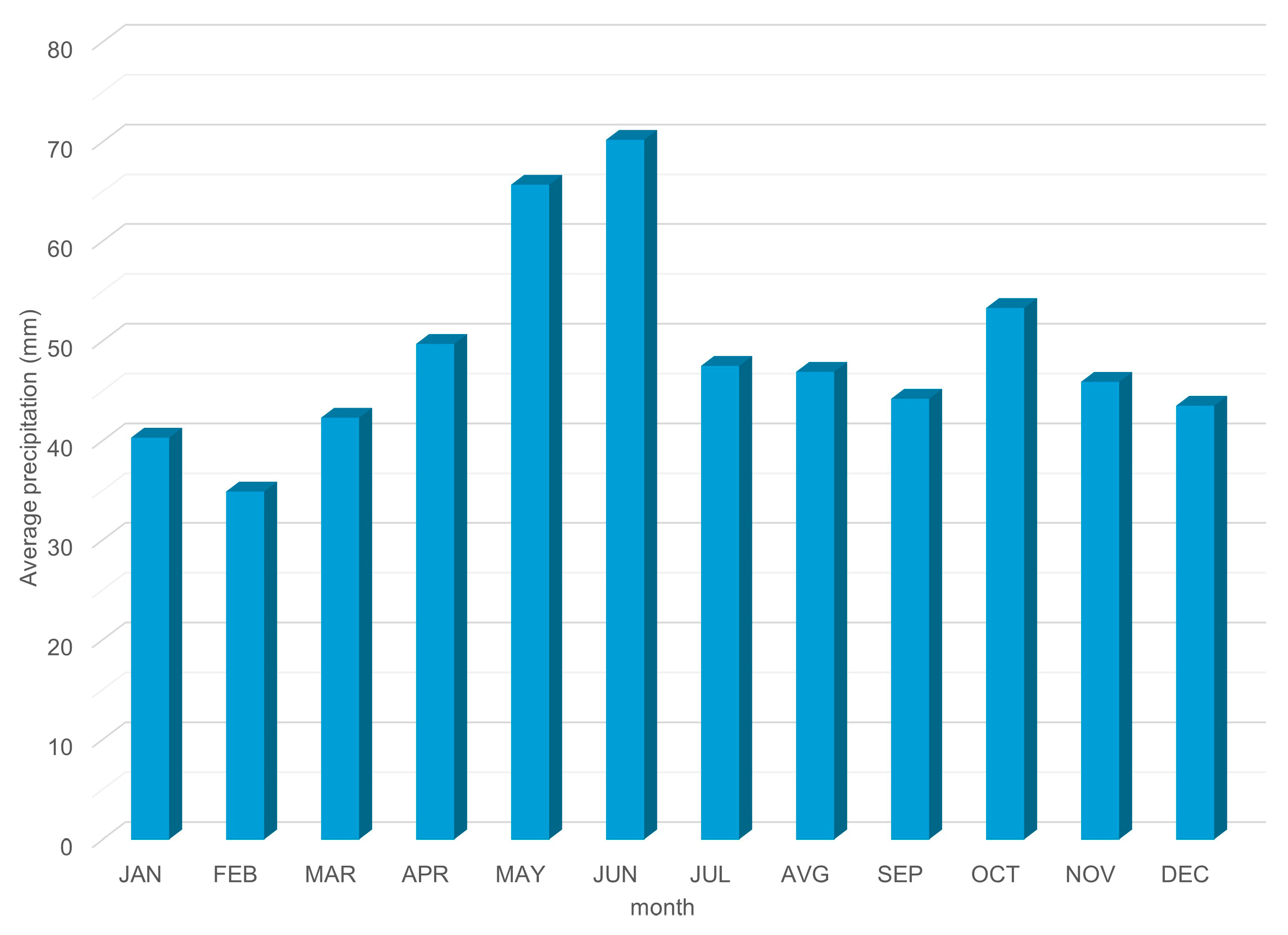
The territory of the city of Pirot is characterized by a typical temperate–continental climate, but since this area covers a large area with relatively large differences in altitude, in addition to the temperate–continental climate, the research area also has a mountain climate that covers almost the entire area of the Stara Planina Mountain. Peculiarities of this climate are relatively warm summers and harsh winters, with a recession period from August to October, which usually affects the groundwater. As a rule, the highest precipitation occurs in May and June and is uneven both during the year and on a daily basis. For the period 1991–2019 (Figure 2), the average annual amount of precipitation was 584.3 mm. The maximum annual amount of precipitation occurred in 2014, when a total of 918.1 mm of rain fell, while the driest year was 2000, with only 261.2 mm of total rain.
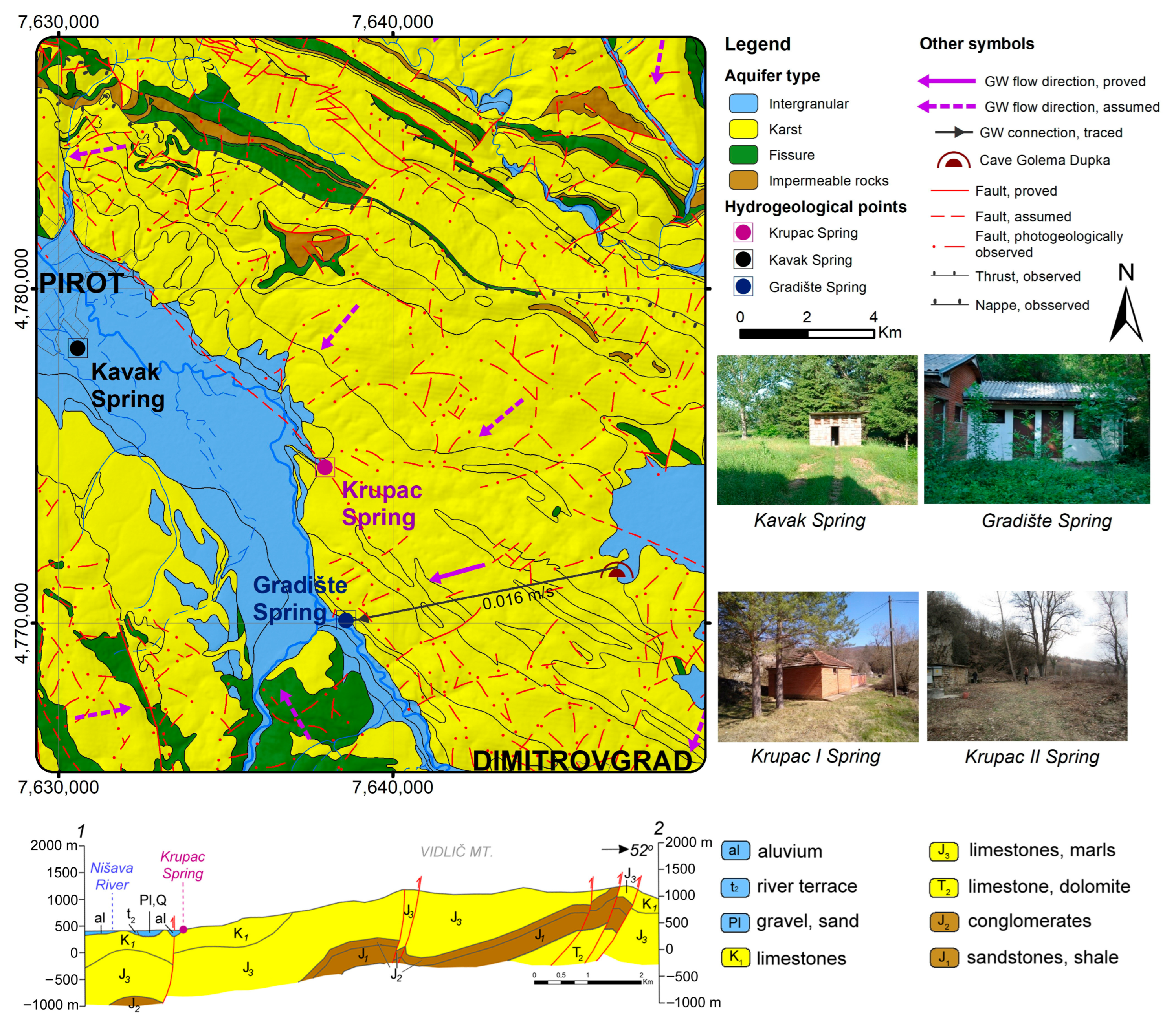
By analyzing the geological and hydrogeological characteristics of the researched area, it can be concluded that the basic hydrogeological collector of groundwater, which is drained at the Kavak Spring, the Krupac Spring and the Gradište Spring, consists of Tithonian banked and massive limestones, light gray or yellow in color, which may also contain a marl component (Figure 3). A significant amount of the water also infiltrates the karst formations within the limestone, including marls and sandstones (Wallend–Otriv), while in deeper parts water is accumulated within the Oxford–Kimmeridge limestone. The total thickness of the water-bearing rocks in which the karst aquifer was formed is over 500 m. The (conditionally) impermeable bedrock of the karst aquifer is most probably represented by Lower Jurassic sediments, mainly composed of quartz conglomerates and various sandstones, their total thickness reaching up to 250 m.
The Kavak Spring (Figure 3) is located in the Pirot basin, southeast of the city at an altitude of 370.5 m above sea level. It is characterized by a very stable outflow regime (Qmin of about 85 L/s), which indicates the existence of deep channels, where waters have spent a prolonged period within the system. During the summer (the season of high water consumption), the highest amount of spring water is used for water supply. The water is used without any treatment except preventive chlorination.
The Krupac water source consists of two karst springs: Krupac 1 and Krupac 2, tapped for the Pirot City water supply, located 10 km southeast of Pirot, at an altitude of 395 m, and at a distance of 120 m from each other (Figure 3). During long-term research, the minimum yield of Krupac 1 was about 220 L/s, while that of Krupac 2 was about 50 L/s. According to their characteristics, the springs are of the gravity circulation type.
The Gradište Spring is located in the village of Gradište at an altitude of 414 m a.s.l. (Figure 3) on the eastern edge of the Pirot basin and represents a spring that, in addition to the development of shallower karst conduits, also has a developed deeper karst conduit network. The minimum spring discharge is about 105 L/s. The watershed area of the Gradište Spring covers 47 km2, with a part of the Odorovačko with the Golema Dupka Ponor at 686 m a.s.l., for which a direct connection with the spring was confirmed by a tracer test.

3. Materials and Methods

Research on karst aquifer distribution within the host rock is extremely complex, since karst channels are often small in size and zonally distributed within a vertical profile, where some conduits can be developed at a depth of several hundreds of meters. Therefore, for the purposes of defining the regimes and reserves of karst aquifers, as well as defining the genesis of groundwater, it is very important to apply a multi-parametric approach, which includes several methodological approaches.
In order to define the genesis of the groundwater from the Kavak Spring, Krupac Spring and Gradište Spring, the groundwater regime was observed during one hydrological year (spring 2021–spring 2022), where the yield was measured on a daily basis, while chemical and bacteriological analyses were carried out on a monthly basis by the Pirot Public Health Institute, with analyses including determination of the contents of trace elements, radioactivity and the contents of pollutants conducted quarterly, i.e., seasonally (Laboratory ANAHEM d.o.o. Serbia). Also, specific tracer tests were carried out in order to define the direct connections of the ponor (swallow-hole) zones within the recharge zone with the karst springs. During these investigations, the connection of the Gradište Spring with the Ponor–Golema Dupka, located in the Odorovačko Polje, was unequivocally established (Figure 3).
In addition to classical hydrogeological research, determinations of groundwater age were also carried out using natural tracers. To define the young groundwater component, the tritium and 3H + 3He method is the most reliable, while for defining old waters, radiocarbon isotope measurement represents an excellent tool. Since karst waters are most often a mixture of young, semi-young and old waters, both dating methods were used for this study. The Krupac Spring, based on the quantity and quality regime, is a spring with a typical gravity type of circulation; therefore, the Kavak Spring and Gradište Spring were chosen for groundwater aging sampling, since, based on previous data, it was assumed that these two karst systems are characterized by deep siphonal circulation. During the summer period, samples were taken for analysis of the contents of stable isotopes of oxygen, hydrogen and carbon, as well as for groundwater dating with tritium, 3H + 3He and 14C isotopes [21,22].
Also, on the sampling occasion, noble gas samples were taken in order to calculate the groundwater recharge temperature, i.e., the temperature that prevailed in the recharge zone at the moment when the water entered the system. The results for the noble gases provide an insight into the paleoclimatic conditions that prevailed at the time of recharge [23,24], i.e., the temperature regime of the air that prevailed in that period. The content of noble gases dissolved in water within closed or semi-closed aquifers does not change, even over thousands of years, considering their inertness towards chemical and biological processes, but they can be influenced by physical processes (radioactive decay, diffusion and solubility), which consequences may be removed using isotopic ratios. The temperature dependence of the noble gases actually gives the possibility of determining the groundwater recharge temperature. The temperature of the noble gases, together with dating data for groundwater, is a good indicator of the paleoclimatic conditions that prevailed in a certain area [25,26,27]. The samples were taken at Kavak Spring and Gradište Spring. Water for isotope and noble gas analyses was transported to the laboratory of the Institute for Nuclear Research, Hungarian Academy of Sciences, Debrecen, Hungary, where the analyses were performed.
Tracer tests provided highly significant results for understanding the genesis of groundwater within the Vidlič karst massif. The experiments were carried out using na-fluorescein as the primary tracer, which was injected into the swallow hole (ponor) at the Odorovačko Polje. Such tracer studies are widely applied and represent one of the indispensable methods in karst hydrogeological investigations [28,29].

4. Results

4.1. Results for Discharge Regime

Monitoring of the discharge at the Krupac Spring (Krupac 1 and Krupac 2) revealed that the capacity of the spring varied from 260.57 L/s (December 2022) to 1617.13 L/s (April 2021), resulting in a coefficient of hydrodynamic unevenness of Qmax:Qmin = 6:1. The Gradište Spring has a lower capacity, and the quantities varied from 89 L/s (March 2022) to 502 L/s (March 2021) and the coefficient of hydrodynamic unevenness was Qmax:Qmin = 5:1. The lowest amount of water is drained at the Kavak Spring and varies from 19.4 L/s (March 2021) to 123.13 L/s (February 2022), and the coefficient of hydrodynamic unevenness is Qmax:Qmin = 6:1. Analyzing the results, the mean capacities of the springs were determined to be 523.7 L/s for Krupac Spring, 207.44 L/s for Gradište Spring and 98.80 L/s for Kavak Spring [30].
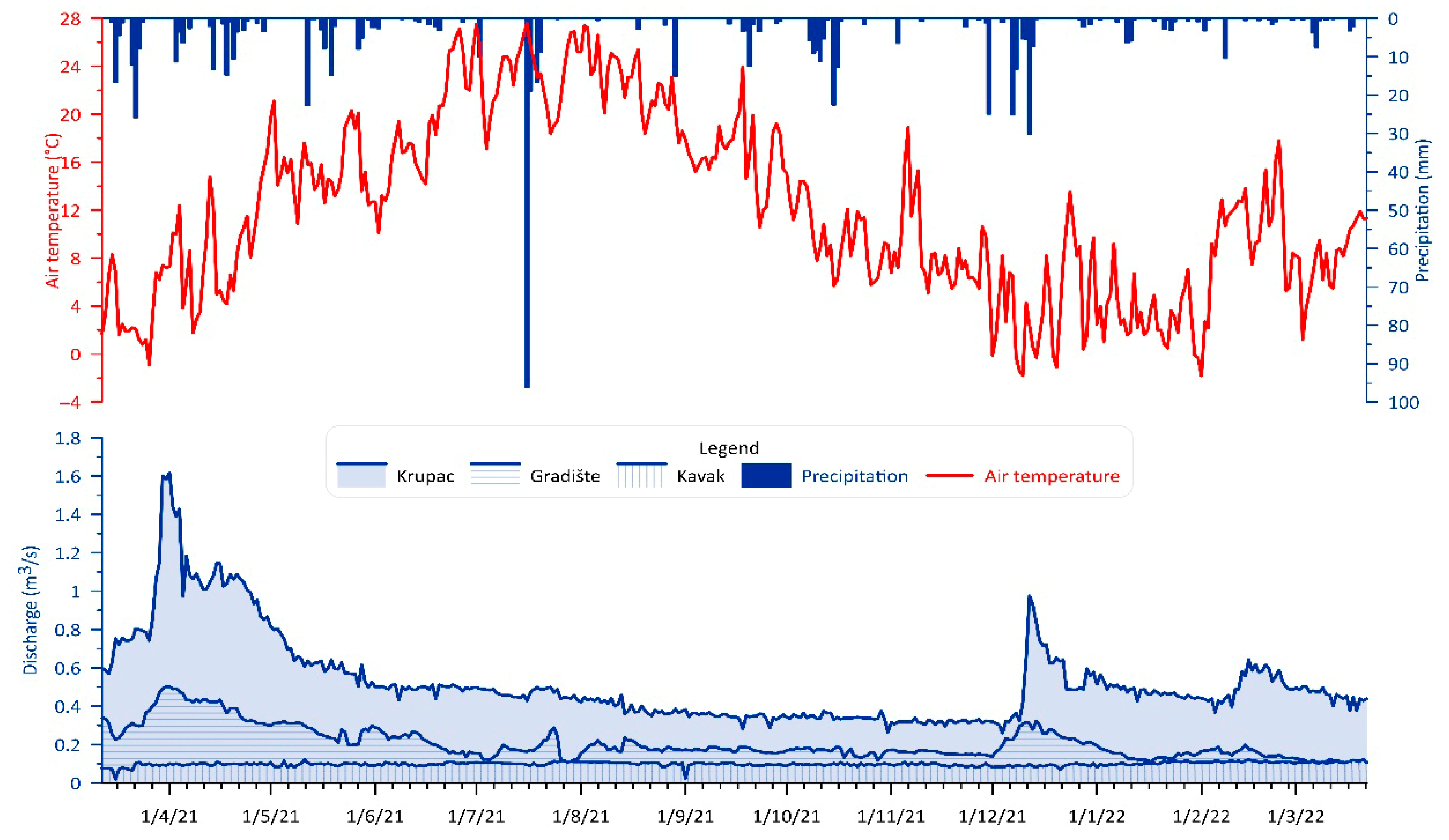
The regime of karst groundwater is characterized by very large dynamic changes during one hydrological cycle. According to quantitative characteristics, it is noticeable that the amount of groundwater directly depends on the groundwater recharge process, meaning the rainfall regime. The impact of falling rain, i.e., effective infiltration, is not uniform throughout the year and is most pronounced in the autumn period (during intense autumn rains), i.e., during the spring period, when, in addition to the rains, the snow cover also melts. For the monitored period at the Dimitrovgrad rain gauge station (RGS), located near Pirot, and the springs (period March 2021–March 2022), it was observed that the highest amount of rain fell during July 2021, 150.7 mm, and the least during June 2021, with only 14.5 mm of rain. During the entire mentioned period of 12 months, a total of 691.20 mm of rain fell, i.e., an average of 53.17 mm per month. A comparative diagram of daily precipitation values (RGS Dimitrovgrad) and spring discharge from the springs—Kavak, Krupac and Gradište—is shown in Figure 4. Figure 4 illustrates a pronounced peak in precipitation during July, which did not result in an increased discharge at the monitored springs. This observation is characteristic of the behavior of a complex karst system, where, depending on antecedent meteorological conditions, a considerable portion of precipitation is retained within the epikarst and the unsaturated zone of the aquifer. Consequently, groundwater circulation during low-flow periods is considerably slower. Such knowledge contributes to a deeper understanding of the genesis of complex karst systems in specific areas.

4.2. Results for Groundwater Quality Regime

The regime of the hydrochemical characteristics of the karst spring groundwater was monitored using the results of monthly analyses (physico-chemical parameters, main ions and bacteriological composition) and four periodic analyses, which, in addition to the basic chemical parameters, also included the measurement of contents of microelements, bacteriology and radioactivity.
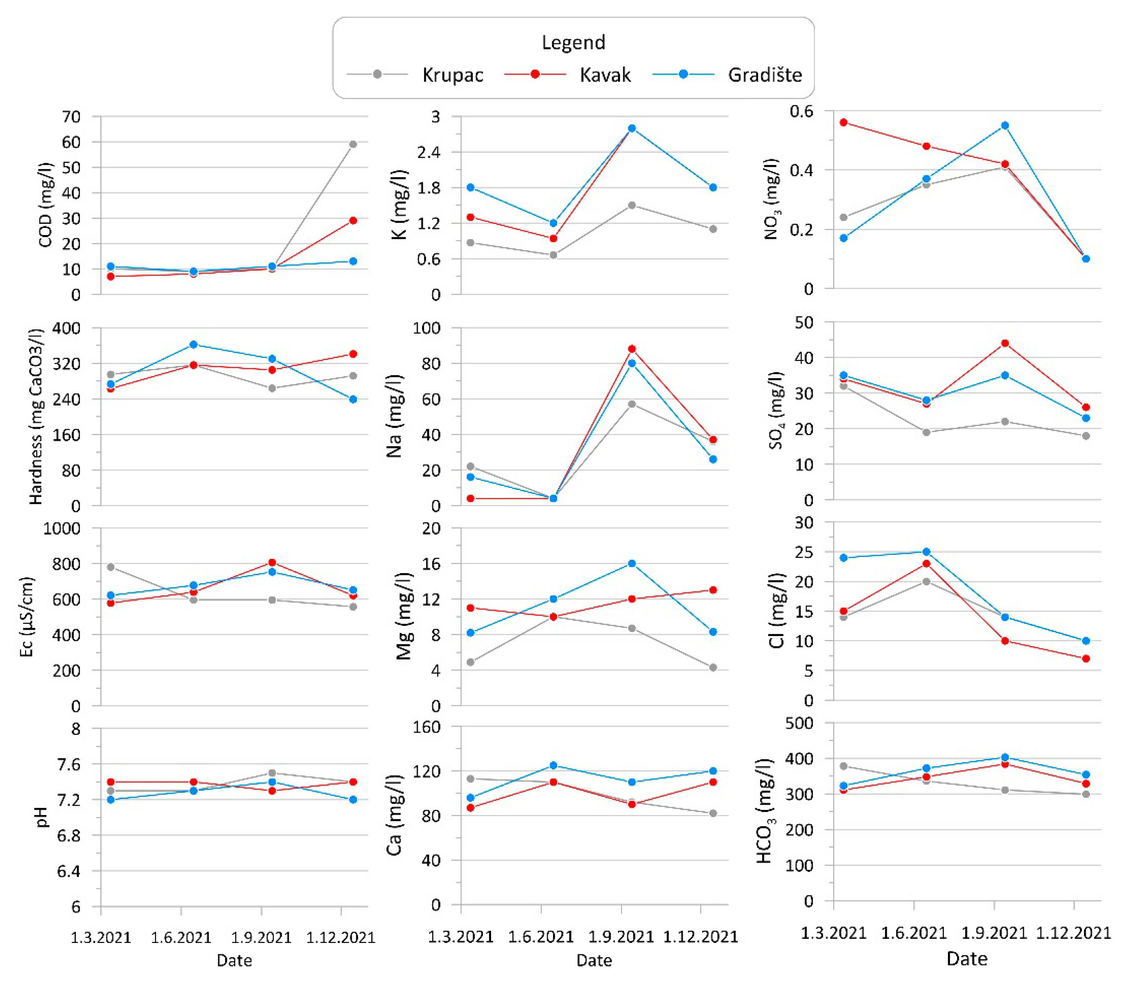
The waters of the springs, Kavak, Krupac and Gradište, are characterized by good physical and chemical characteristics that are favorable for water supply purposes. The pH value of all waters is neutral and ranges from 7 to 7.4, indicating standard values within karst aquifers [31]. The water temperature indicates the seasonal influence, but the temperature at Kavak and Gradište is slightly higher during the summer period, reaching up to 16.3 °C, a possible result of water outflowing from deeper channels. Electrical conductivity also indicates fluctuations with a seasonal character. The lowest values were registered in the period of high water (557 µS/cm at the springs Krupac 1 and 2), while the highest value of 806 µS/cm was recorded during the summer period at the Kavak Spring. It is important to emphasize that the waters are remarkably clear, and at all three springs values over 1 NTU were not recorded, except for samples from the springs Krupac 1 and 2, registered in the period of high water, whose values were slightly higher than 1 NTU, which confirms the conclusion that the waters of these two springs belong to the gravity type of circulation. The change in the basic physical and chemical parameters of water at the quarterly level is shown in Figure 5.
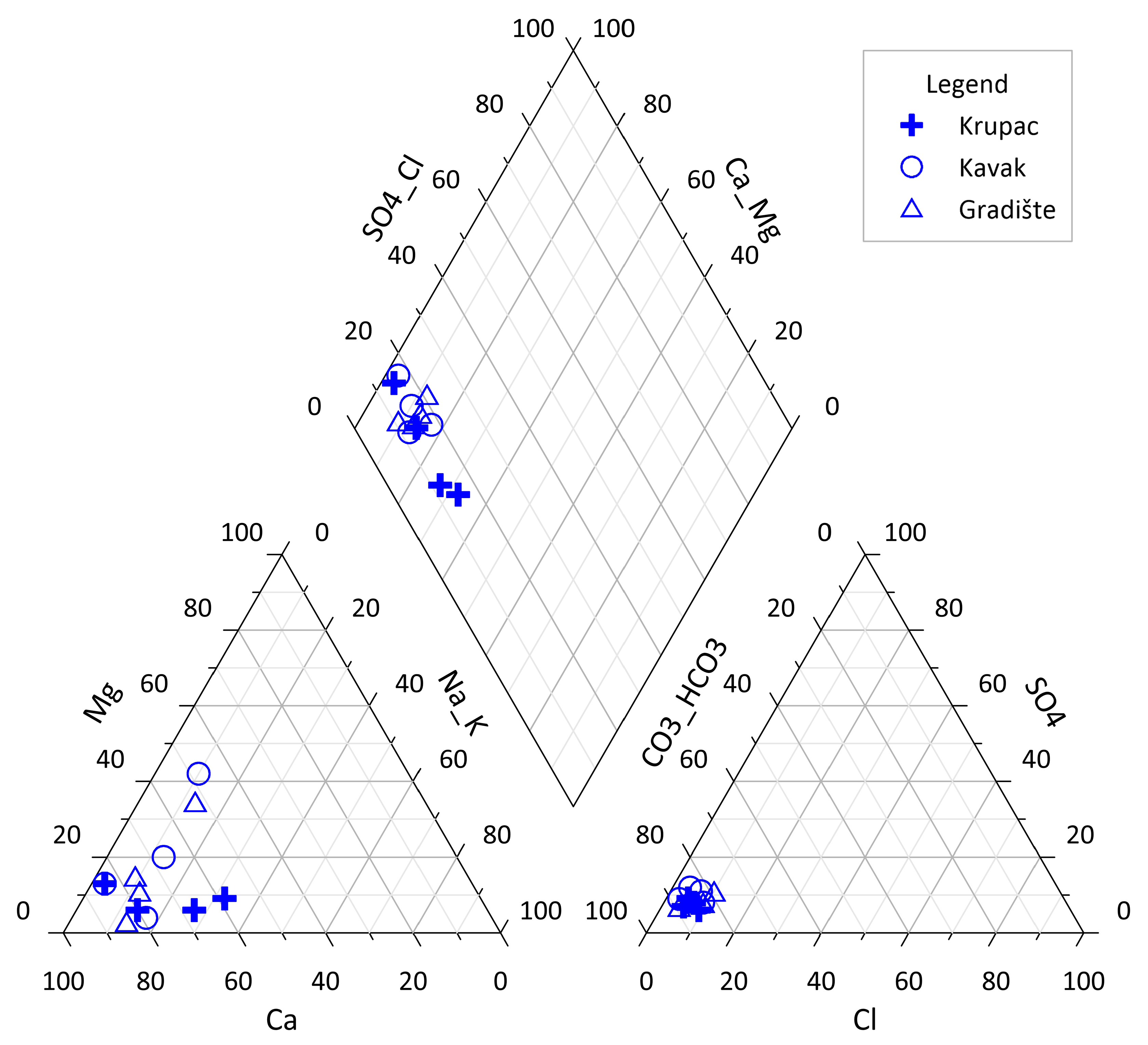
Bicarbonate ions (HCO3) dominate the anionic composition at all springs; the lowest values of 229 mg/L were recorded at the Krupac Spring and the highest values of 403 mg/L at Gradište Spring. Next are sulfate ions (SO42−), with values varying from 18 mg/L (Krupac) to 44 mg/L (Kavak and Gradište). Chloride values are low and range from 7 mg/L (Kavak) to the maximum recorded value of 25 mg/L at the Gradište Spring. The contents of nitrate (NO3) and nitrite (NO2) are extremely low, considering water from karst; samples from all three springs did not have higher values than 0.03 mg/L for nitrites, while nitrate values did not exceed 1 mg/L. The cationic composition is dominated by calcium ions (Ca2+), with values varying from 82 mg/L to the maximum recorded value of 125 mg/L at the Gradište Spring. Magnesium (Mg2+) values ranged from 4 mg/L (Krupac) to 16 mg/L at Kavak Spring. The values of sodium (Na+) are relatively high for karst aquifers, with a maximum recorded value of 88 mg/L, indicating waters that, in addition to limestone rocks, might have been in contact with other types of rocks. However, these values are significantly below the maximum values allowed for drinking water [32]. The change in the basic ion composition in the water at the quarterly level is shown in Figure 5. Also, the ion composition of all three springs is shown in a Piper diagram (Figure 6). The contents of all trace elements in all samples were within the permissible limits, with a maximum iron content of 0.015 mg/L at the Krupac Spring, which was still below the maximum allowed value for drinking water. A Piper plot (Figure 6) provides additional confirmation of the differing groundwater circulation conditions among the three springs. It is evident that the water discharged from the Krupac Spring experiences significantly shorter residence times in the subsurface, indicating limited interaction with the geological formations through which it flows. This observation has also partially influenced the development of the conceptual model of groundwater circulation within this complex karst system.

4.3. Results of Tracer Test

Within the study area, a tracer test was conducted at the swallow hole (ponor) of the Odorovačka River in the Vidlič massif. The experiment was carried out by a professional team from the Geological Institute (Geozavod), Belgrade. The tracer traveled a straight-line distance of 8.3 km, from the Ponor–Golema Dupka to the Gradište Spring, with an apparent velocity of 0.016 m/s (Figure 2).
Tracing at the Ponor–Golema Dupka confirmed that, under a swallowing capacity of 60 L/s and during high-discharge conditions at the observed springs, the sinking water emerged at the Gradište Spring as well as at the Krupac 1 and Krupac 2 Springs, located in the village of Krupac [33]. Under conditions of reduced swallowing capacity (15 L/s) and low spring discharge, the underground connection was established only with the Gradište Spring.

4.4. Results for Stable and Radioactive Isotopes

During water sampling for the purpose of dating the groundwaters of the Kavak and Gradište Springs, samples were also taken to define the contents of stable isotopes of oxygen, hydrogen and carbon. The values of stable oxygen and hydrogen isotopes at the Kavak Spring were −10.88‰ (18O) and −75.6‰ (2H), while at Gradište the values were −10.35‰ (18O) and −71.23‰ (2H) (Table 1). The value of the stable isotope δ13C at the Kavak Spring was −5.02‰, which indicates a slightly longer stay of water in the system compared to the value for δ13C at Gradište, which was −6.05‰ (Table 1).
The results for radioactive isotopes were used in the calculation of the age of the groundwater. The content of tritium in the Kavak Spring is 2.89 TU, while the content in the Gradište Spring is slightly higher at 3.26 TU. Also, the 14C isotope content at the Kavak Spring is 53.94 pMC, while the value at Gradište is 62.18 pMC (Table 2). This information indicates that, in addition to young water in the systems of these springs, there are also channels containing older water, i.e., that the water drained from Kavak and Gradište is a mixture of young and old water.
For the purpose of defining the contents of the young waters, the content of He was also determined (via the T + He method), and to define the temperature conditions at the moment of infiltration of the water from the surface, the composition of other noble gases was also determined (Table 3). The calculation showed that the groundwaters of the Gradište Spring infiltrated the system at an air temperature of 8.74 °C, while the waters of Kavaka infiltrated the system at a temperature of 8.14 °C. A more detailed explanation will be provided in the Discussion section.
For the Gradište Spring, based on the results for 3H/3He, the age of the semi-young component of the water was calculated to be 53.8 years, indicating that the water infiltrated the system in 1967, which confirms the hypothesis that, in addition to the channel with young waters that circulate directly from the ponor of Golem Dupka, there is also a channel of deep circulation in which the water has stayed for 53.8 years.
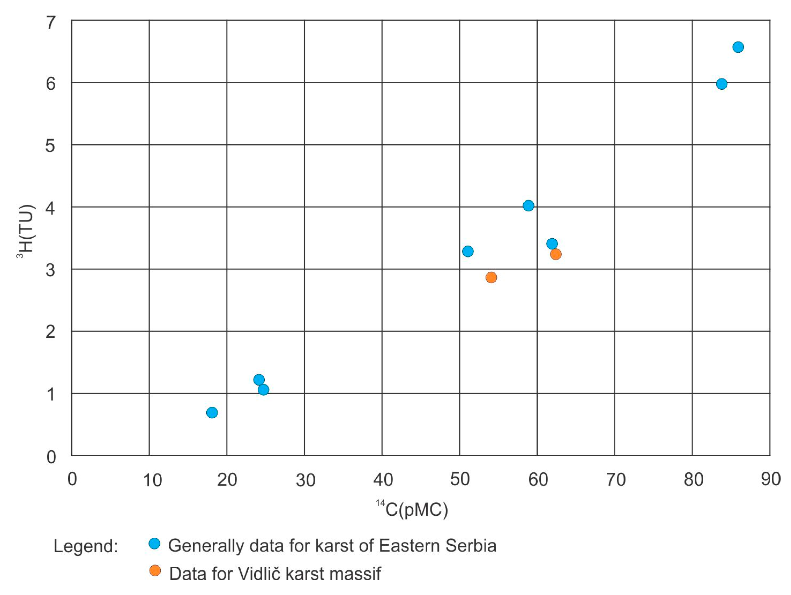
The best confirmation of the zonal distribution of karst channels at greater depths is provided by the results for stable and radioactive isotopes, as well as the results for the noble gas contents. Looking at Figure 7, a linear correlation of tritium and radiocarbon can be seen. In the plot blue dots represent the Karphato–Balkanides (KB) karst water samples, while Kavak and Gradište samples are shown as orange dots (the same in all figures). Some of the KB samples have very low radiocarbon contents (<30 pMC), while significant tritium contents can be observed (~1 TU). This clearly indicates the presence of a fresh and an old component. Comparing the Pirot samples (Kavak and Gardište) with the KB waters, they fit very well the relationship between 3H and 14C, although the study sites are far from each other. Kavak and Gradište have tritium concentrations of 2.9 and 3.3 TU. Since the annual mean average tritium content of precipitation is about 8 TU (Mook, 2000), this means that either tritium has already decayed (the age would be 16–18 years) or that a fresh component is mixing with an old component with no tritium. The latter is confirmed by the lower radiocarbon content.
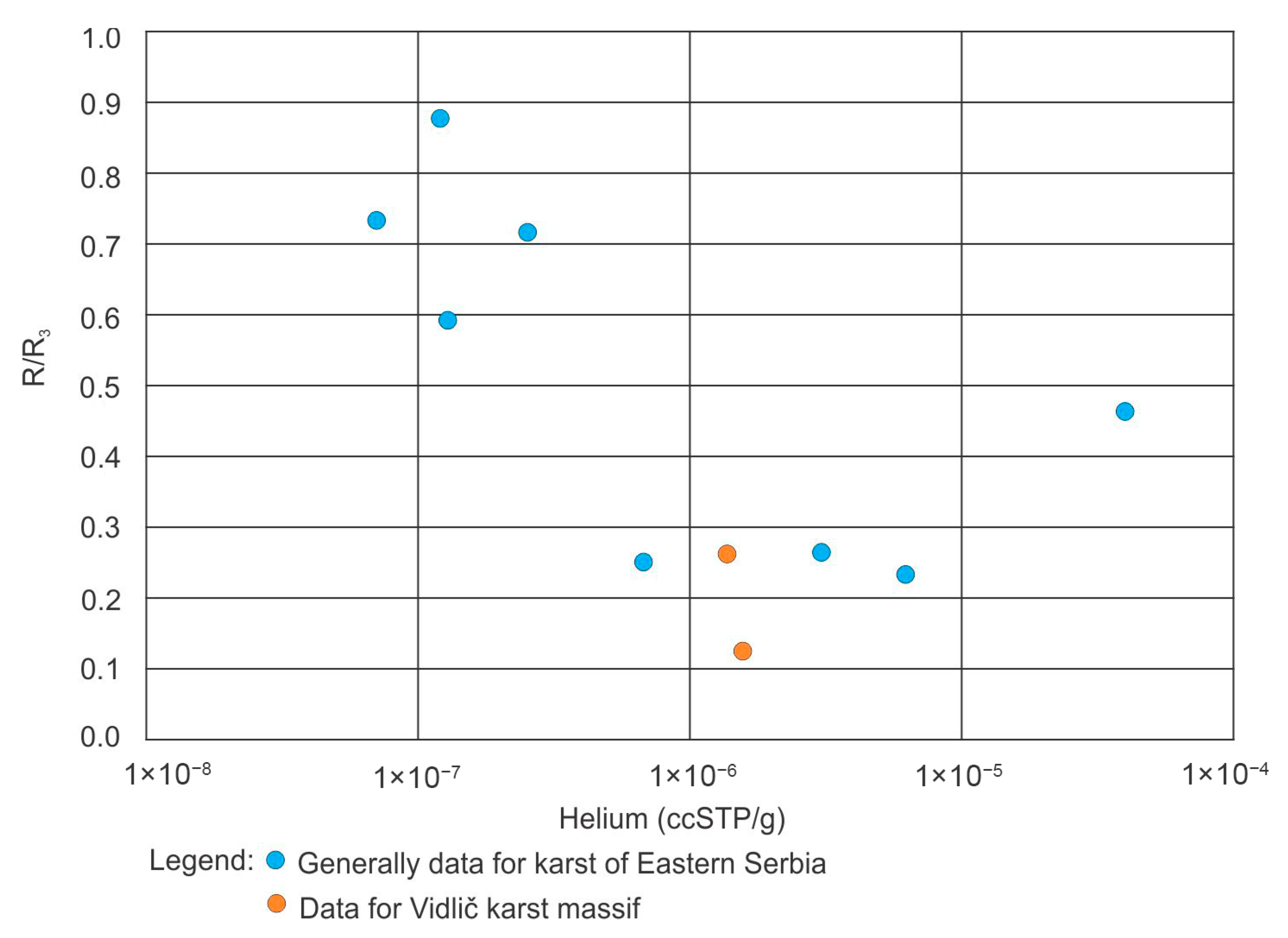
The radiocarbon content of dissolved organic carbon in fresh karst water can be 85–95 pMC. The Kavak and Gradište samples exhibit a level of 54–62 pMC, indicating an apparent age of 3000–4200 years for the old component of the water. However, radiocarbon content can be lowered by dissolution of the host rock with no 14C. The stable isotope composition of carbon (δ13C) is fairly positive in the Kavak and Gradište samples (−5 and −6‰), which indicates a significant contribution of dead carbon dissolution. So, it is not possible to decide whether the radiocarbon is lower due to radioactive decay or dead carbon dissolution. Since radiocarbon alone cannot say anything about the age of the old component, dissolved helium was taken into account. Terrigenic helium is mainly produced by alpha-decays of uranium and thorium chains. In water, the higher the helium concentration, the lower the 3He/4He isotope ratio (since alpha decay produces 4He isotopes). In Figure 8, it can be seen that the 3He/4He isotope ratios of the Kavak and Gradište samples are low (expressed in R/Ra, where R and Ra are the 3He/4He isotope ratios for the samples and air, respectively), while the helium concentrations are relatively high. These values indicate that the water must have an old component. However, it is very difficult to convert the helium signature to the age. The noble gas recharge temperatures indicate that the old component recharged in a climate similar to today’s. This was also confirmed by the stable hydrogen and oxygen isotope composition of the water.
However, the helium concentration of Gradište is 30 times higher than the solubility equilibrium concentration; hence, the calculation may be not so accurate, but we could calculate an apparent 3H/3He age of 54 years, though this may be relevant only to the young component, which means that water infiltrated into the system in 1967.
In the end, it can be concluded that the waters of the Kavak, Krupac and Gradište Springs represent waters of a complex karst aquifer in which the water has spent from a few days, which was confirmed by the groundwater dating survey, to several tens of years, which was defined by the tritium and helium method for the Gradište Spring (54 years), up to several thousand years (3000–4200 years), which can be concluded on the basis of the carbon isotope content.

5. Discussion

Detailed hydrogeological investigations of the Kavak, Krupac and Gradište groundwater proved the existence of significant reserves of groundwater in this complex karst system, which are distributed in cracks and channels at smaller, but also deeper, horizonts. Due to the quantitative characteristics of karst aquifers, it is noticeable that the amount of groundwater in karst aquifers directly depends on the process of their recharge (precipitation regime). However, it is important to point out that even in extremely long periods of recession, the water at the springs did not dry up, indicating the existence of significantly deeper siphonal circulation and the existence of medium-aged and older water.
The quality of the groundwater is very good, and apart from the occurrence of bacteriological pollution, which can be removed by simple chlorination, there is no need for other treatments. The waters are generally of a hydrocarbonate–calcium type, good for water supply needs. The existence of deep siphonal circulation and available reserves even in the period of recession is proven by the qualitative parameters of all three springs, since with the prolonged stay of water in the system, there are also increased values for electrical conductivity, total mineralization and temperature, all of which provide confirmation of the long-term residence of water in the system, deeper deposits within the system and prolonged contact of the water with the host rock.
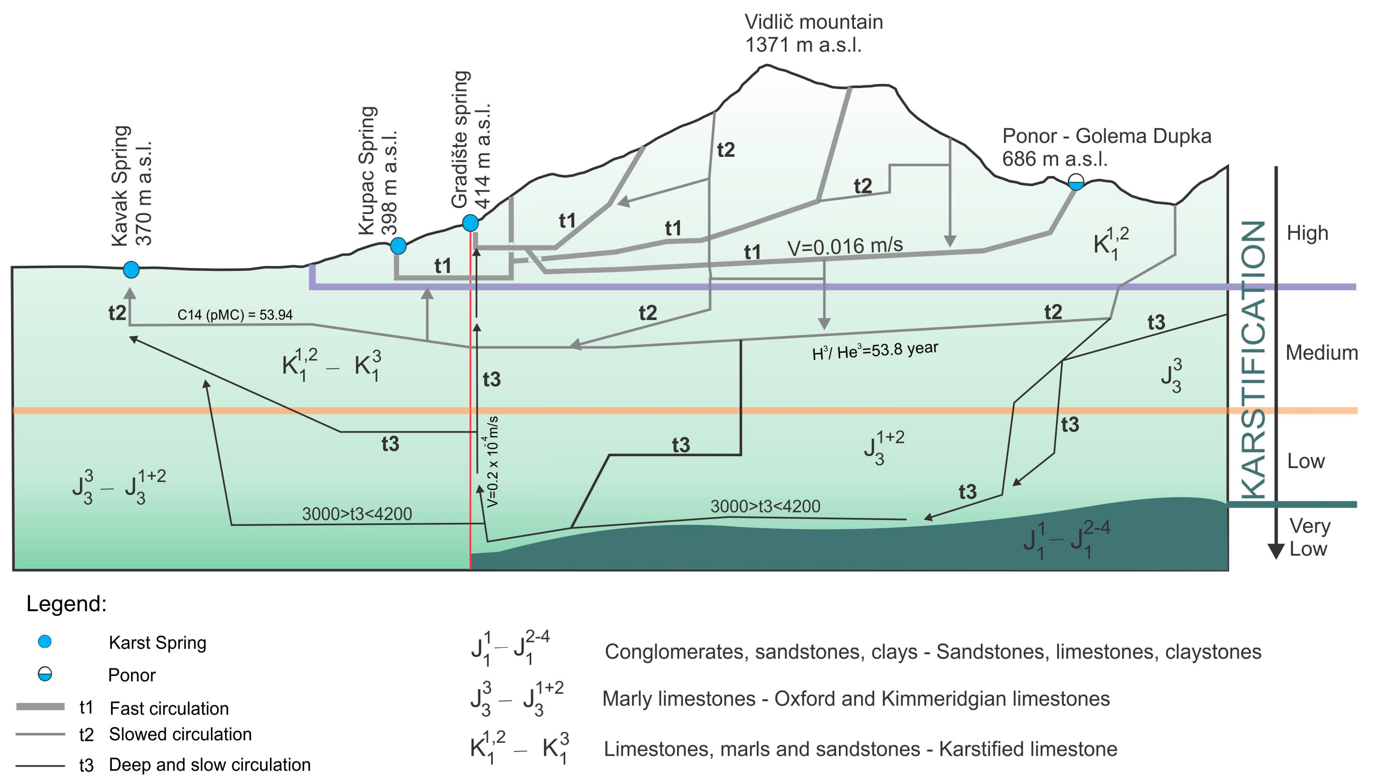
Finally, along with the obtained data and performed analyses, as well as previously collected data about groundwater circulation within the Stara Planina and the Vidlič karst massif, a schematic overview of the groundwater genesis and circulation in the complex karst system of the three discharge zones in the Pirot basin is presented in Figure 9. As can be seen from this schematic projected profile, this is a system of the Vidlič karst massif in which three types of circulation can be clearly differentiated. The first type is fast circulation (t1 channels), where waters fully reflect an active karst system that reacts very quickly to precipitation, both in the immediate vicinity of the discharge zone and in the remote zones of this system. The second type of circulation occurs in channels with much smaller dimensions (t2 channels), which often need a much longer period of time to “intrude” into the main conductors. In the case of this karst system, it is also assumed that they lie deeper than the main t1 channels and that they later connect with the main channels and discharge by ascending to the surface, which is supported by the groundwater age determined by the above-mentioned surveys of these waters. The channels of the t3 group are located much deeper and can be considered as a transition zone, that is, a mixing zone with the oldest waters of the system. Based on this, it is assumed that the channels of group t3 developed to depths of 500 m. The deepest circulation of this system with the oldest (3000–4200 years) groundwater, confirmed by 14C isotope analysis, occurs in the t3 zones. The schematic profile (Figure 9) shows the assumed circulation system of the Vidlič karst massif in a projected cross section.

6. Conclusions

The results of detailed research on three springs tapped for water supply needs in the town of Pirot and the surrounding villages are sufficient for proposing the conclusion that the complex karst system, in addition to being characterized by exceptional quality and significant available groundwater reserves, also has water that is located at significantly greater depths and has been in the system for several tens or even thousands of years. This information is important for strategic planning of water resource management in case of excessive pollution and climate change pressures in dry and flood periods, which may have a negative impact on the delivery of water to consumers due to strong turbidity in the event of a flood wave or reduced amounts of water drained in periods of long-term drought. Regulation of karst aquifers and capture of semi-young and old waters by deep wells and boreholes are ideal solutions for overcoming all the mentioned problems.

Author Contributions

Conceptualization, L.V. and S.M.; methodology, L.V., S.M. and L.P.; investigation, L.V., S.M., V.M. and B.P.; editing, L.V. and S.M.; visualization, L.V., S.M. and B.P.; supervision, S.M.; funding acquisition, L.V., L.P. and S.M. All authors have read and agreed to the published version of the manuscript.

Funding

This research was funded by the Ministry of Science, Technological Development and Innovation of Republic of Serbia, contract nos. 451-03-66/2024-03/200126 and 451-03-65/2024-03/200126.

Data Availability Statement

The original contributions presented in this study are included in the article. Further inquiries can be directed to the corresponding author.

Acknowledgments

The authors would like to thank to the Pirot waterworks of Pirot Town for help in the field research.

Conflicts of Interest

The authors declare no conflicts of interest. The funders had no role in the design of the study; in the collection, analysis or interpretation of data; in the writing of the manuscript; or in the decision to publish the results.

References

  1. Ford, D.; Williams, P. Karst Geomorphology and Hydrology; Caphman & Hall: London, UK, 1989; ISBN 0 412 44590 5. [Google Scholar]
  2. Fatchurohman, H.; Adji, T.N.; Haryono, E.; Wijayanti, P. Baseflow index assessment and master recession curve analysis for karst water management in Kakap Spring, Gunung Sewu. IOP Conf. Ser. Earth Environ. Sci. 2018, 148, 012029. [Google Scholar] [CrossRef]
  3. Vasić, L.; Milanović, S.; Stevanović, Z.; Palcsu, L. Definition of groundwater genesis and circulation conditions of the complex hydrogeological karst system Mlava-Belosavac-Belosavac-2 (eastern Serbia). Carbonates Evaporites 2020, 35, 16. [Google Scholar] [CrossRef]
  4. Iacurto, S.; Grelle, G.; De Filippi, F.M.; Sappa, G. Karst Recharge Areas Identified by Combined Application of Isotopes and Hydrogeological Budget. Water 2021, 13, 1965. [Google Scholar] [CrossRef]
  5. Wang, Z.; Torres, M.; Paudel, P.; Hu, L.; Yang, G.; Chu, X. Assessing the Karst Groundwater Quality and Hydrogeochemical Characteristics of a Prominent Dolomite Aquifer in Guizhou, China. Water 2020, 12, 2584. [Google Scholar] [CrossRef]
  6. Liu, J.; Wu, J.; Rong, S.; Xiong, Y.; Teng, Y. Groundwater Vulnerability and Groundwater Contamination Risk in Karst Area of Southwest China. Sustainability 2022, 14, 14483. [Google Scholar] [CrossRef]
  7. Ford, D.; Williams, P. Karst Hydrogeology and Geomorphology; Willey: Hoboken, NJ, USA, 2007. [Google Scholar]
  8. Yuan, D. Karst of China; China Geological Publishing House: Beijing, China, 1991. [Google Scholar]
  9. Yuan, D. Sensitivity of karst process to environmental change along the PEP II transect. Quat. Int. 1997, 37, 105–113. [Google Scholar] [CrossRef]
  10. Yuan, D.X.; Cai, G.H. The Science of Karst Environment; Chongqing Publishing House: Chongqing, China, 1988. (In Chinese) [Google Scholar]
  11. Vasić, L.; Palcsu, L.; Huang, F. Groundwater Gravitational Circulation of Karst Veliko Vrelo and Malo Vrelo Springs by Isotope and the Noble Gas Method: Case Study of the Beljanica Massif; Springer: Berlin/Heidelberg, Germany, 2019; Volume 78. [Google Scholar] [CrossRef]
  12. Dogančić, D.; Afrasiabian, A.; Kranjčić, N.; Đurin, B. Using Stable Isotope Analysis (δD and δ18O) and Tracing Tests to Characterize the Regional Hydrogeological Characteristics of Kazeroon County, Iran. Water 2020, 12, 2487. [Google Scholar] [CrossRef]
  13. Frank, S.; Fahrmeier, N.; Goeppert, N.; Goldscheider, N. High-resolution multi-parameter monitoring of microbial water quality and particles at two alpine karst springs as a basis for an early-warning system. Hydrogeol. J. 2022, 30, 2285–2298. [Google Scholar] [CrossRef]
  14. Dai, L.; Zhao, Y.; Yin, C.; Mao, C.; Zhang, P.; Zhou, F.; Yu, X. Spatial and Temporal Dynamics of Drought and Waterlogging in Karst Mountains in Southwest China. Sustainability 2023, 15, 5545. [Google Scholar] [CrossRef]
  15. Jia, Z.; Zang, H.; Zheng, X.; Xu, Y. Climate Change and Its Influence on the Karst Groundwater Recharge in the Jinci Spring Region, Northern China. Water 2017, 9, 267. [Google Scholar] [CrossRef]
  16. Pedrosa Bhering, A.; Antunes, I.M.H.R.; Nascimento Catão, G.; Gomes Marques, E.A.; de Paula, R.S.; Brito Andrade, I.; Rebelo Diório, G. Groundwater Model for Karst and Pelitic Aquifer Systems from a Semi-Arid Region Under Climate Change Scenarios: A Case Study in the Vieira River Watershed, Brazil. Water 2024, 16, 3140. [Google Scholar] [CrossRef]
  17. Vasić, L.; Milanović, S.; Dašić, T. Definition of Circulation Conditions and Groundwater Genesis of the Complex Krupaja Hydrogeological Karst System (Eastern Serbia). Sustainability 2023, 15, 11146. [Google Scholar] [CrossRef]
  18. White, W.B. Karst hydrology: Recent developments and open questions. Eng. Geol. 2002, 65, 85–105. [Google Scholar] [CrossRef]
  19. Ravbar, N.; Petrič, M.; Kogovšek, J. The characteristics of groundwater flow in karst aquifers during long lasting low flow conditions, example from SW Slovenia. In Advances in Research in Karst Media. Environmental Earth Sciences; Andreo, B., Carrasco, F., Durán, J., LaMoreaux, J., Eds.; Springer: Berlin/Heidelberg, Germany, 2010; pp. 131–136. [Google Scholar] [CrossRef]
  20. Rovan, L.; Lojen, S.; Zuliani, T.; Kanduč, T.; Petrič, M.; Horvat, B.; Rusjan, S.; Štrok, M. Comparison of Uranium Isotopes and Classical Geochemical Tracers in Karst Aquifer of Ljubljanica River catchment (Slovenia). Water 2020, 12, 2064. [Google Scholar] [CrossRef]
  21. Molnár, M.; Rinyu, L.; Veres, M.; Seiler, M.; Wacker, L.; Synal, H.A. EnvironMICADAS: A mini 14 C AMS with enhanced gas ion source Interface in the Hertelendi Laboratory of Environmental Studies (HEKAL), Hungary. Radiocarbon 2013, 55, 338–344. [Google Scholar] [CrossRef]
  22. Palcsu, L.; Gessert, A.; Túri, M.; Kovács, A.; Futó, I.; Orsovszki, J.; Puskás-Preszner, A.; Temovski, M.; Koltai, G. Long-term time series of environmental tracers reveal recharge and discharge conditions in shallow karst aquifers in Hungary and Slovakia. J. Hydrol. Reg. Stud. 2021, 36, 100858. [Google Scholar] [CrossRef]
  23. Aeschbach-Hertig, W.; Peeters, F.; Beyerle, U.; Kipfer, R. Interpretation of dissolved atmospheric noble gases in natural waters. Water Resour. Res. 1999, 35, 2779–2792. [Google Scholar] [CrossRef]
  24. Varsányi, I.; Palcsu, L.; Kovács, L. Groundwater flow system as an archive of palaeotemperature: Noble gas, radiocarbon, stable isotope and geochemical study in the Pannonian Basin, Hungary, Applied Geochemistry. J. Int. Assos. Geochem. 2011, 26, 91–104. [Google Scholar] [CrossRef]
  25. Stute, M.; Schlosser, P. Principles and Applications of the Noble Gas Paleothermometer. Climate Change in Continental Isotopic Records; Geophysical Monograph Series; Swart, P.K., Lohmann, K.C., McKenzie, J., Savin, S., Eds.; American Geophysical Union: Washington, DC, USA, 1993; Volume 78, pp. 89–100. [Google Scholar]
  26. Kipfer, R.W.; Aeschbach-Hertig, W.; Peeters, F.; Stute, M. Noble gases in lakes and groundwaters. In Noble Gases in Geochemistry and Cosmochemistry Reviews in Mineralogy and Geochemistry, v. 47; Porcelly, D., Ballentine, D., Wieler, R., Eds.; AGU Publications: Washington, DC, USA, 2002; pp. 615–700. [Google Scholar]
  27. Vasić, L. Genesis and Groundwater Circulation Conditions of Complex Karst Systems of the Kučaj-Beljanica Massif. Doctoral Dissertation, Faculty of Mining and Geology, University of Belgrade, Belgrade, Serbia, 2017. [Google Scholar]
  28. Benischke, R. Review: Advances in the methodology and application of tracing in karst aquifers. Hydrogeol. J. 2021, 29, 67–88. [Google Scholar] [CrossRef]
  29. Goldscheider, N.; Meiman, J.; Pronk, M.; Smart, C. Tracer tests in karst hydrogeology and speleology. Int. J. Speleol. 2008, 37, 27–40. [Google Scholar] [CrossRef]
  30. Milanović, S.; Vetrović, B.; Ristić-Vakanjac, V.; Vasić, B.; Marinović, V.; Vojnović, P. Simulation of outlook of selected karst springs of the Pirot basin. Vodoprivreda 2022, 54, 315–316. [Google Scholar]
  31. Gao, S.; Li, C.; Liu, Y.; Sun, B.; Zhao, Z.; Lv, M.; Gang, S. Hydrogeochemical Characteristics and Evolution Processes of Karst Groundwater Affected by Multiple Influencing Factors in a Karst Spring Basin, Eastern China. Water 2023, 15, 3899. [Google Scholar] [CrossRef]
  32. Kubisiak-Banaszkiewicz, L.; Żukiewicz-Sobczak, W.; Starek-Wójcicka, A.; Mazur, J.; Sobczak, P. Methods of Assessing Water Quality in Terms of Public Health. Water 2025, 17, 70. [Google Scholar] [CrossRef]
  33. Mandić, M. Karstna vrela Pirotske kotline. Pirot. Zb. 2015, 40, 203–225. [Google Scholar]
Figure 1. Geographic locations of (a) Serbia in Europe, (b) investigated area (red square) and (c) Pirot City and springs (green dots): Kavak, Krupac and Gradište.
Water 17 02807 g001
Figure 2. Intra-annual distribution of mean monthly precipitation amounts (in mm) for the period 1991–2018 for the Pirot climatological station (www.hidmet.gov.rs), accessed on 15 May 2021.
Water 17 02807 g002
Figure 3. Hydrogeological map of the investigated area with characteristic cross section.
Water 17 02807 g003
Figure 4. Comparative diagram of daily values of precipitation (RGS Dimitrovgrad) and discharged water in the springs at Kavak, Krupac and Gradište during the period of hydrogeological research.
Water 17 02807 g004
Figure 5. Variation in physio-chemical characteristics of the Kavak, Krupac and Gradiste karst springs throughout the year.
Water 17 02807 g005
Figure 6. Piper diagram of the springs at Kavak, Krupac and Gradište.
Water 17 02807 g006
Figure 7. Tritium as a function of radiocarbon.
Water 17 02807 g007
Figure 8. 3He/4He isotope ratio (expressed in R/Ra) as a function of the helium concentration.
Water 17 02807 g008
Figure 9. Schematic cross section of the Vidlič karst massif and the Pirot basin showing the distribution of regional karst groundwater circulation toward the Kavak, Krupac and Gradište Springs (projected onto the profile).
Water 17 02807 g009
Table 1. Stable isotope contents in the springs at Kavak and Gradište.
SpringDateδ13C (‰ VPDB)Delta 2HDelta 2H StDevDelta 18ODelta 18O StDev
Kavak1 July 2021−5.02−75.610.70−10.880.09
Gradiste1 July 2021−6.05−71.230.29−10.350.09
Table 2. Isotope 14C contents in the springs at Kavak and Gradište.
SpringDate3H (TU)±1σ (TU)14C (pMC)Error (abs)
Kavak1 July 20212.890.0853.940.22
Gradiste1 July 20213.260.0962.180.20
Table 3. Noble gas contents and NGTs in the springs at Kavak and Gradište.
SpringDateHe (ccSTP/g)Ne (ccSTP/g)Ar (ccSTP/g)Kr (ccSTP/g)Xe (ccSTP/g)R/RaNGT (°C)
Kavak1 July 20211.37 × 10−063.64 × 10−074.68 × 10−049.90 × 10−081.38 × 10−080.2658.14
Gradiste1 July 20211.59 × 10−063.09 × 10−074.27 × 10−049.42 × 10−081.31 × 10−080.1278.74
Disclaimer/Publisher’s Note: The statements, opinions and data contained in all publications are solely those of the individual author(s) and contributor(s) and not of MDPI and/or the editor(s). MDPI and/or the editor(s) disclaim responsibility for any injury to people or property resulting from any ideas, methods, instructions or products referred to in the content.