Integrating Loose Layer Drainage into Mining Subsidence Prediction: A Mathematical Model Validated by Field Measurements and Numerical Simulations
Abstract
1. Introduction
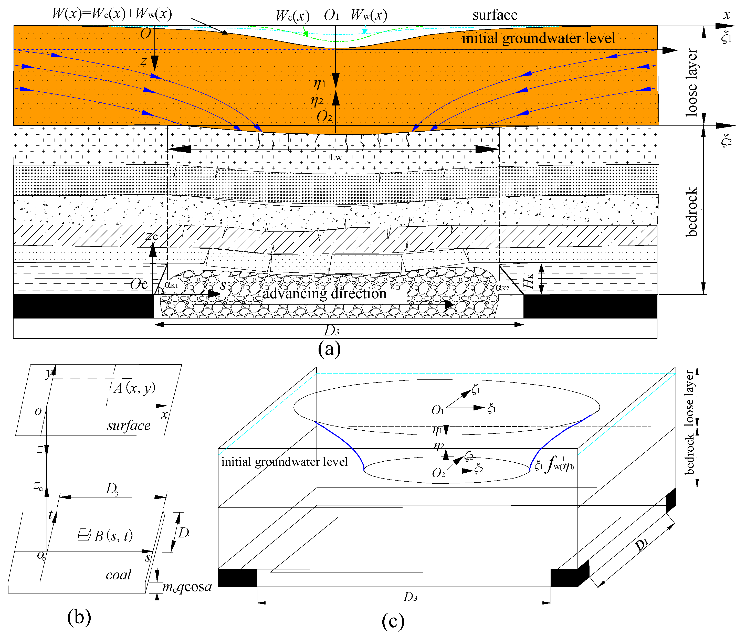
2. Surface Subsidence Prediction Model Considering Both the Effects of Coal Mining and Loose Layer Drainage
2.1. Surface Subsidence Prediction Model Considering the Single Effect of Coal Mining
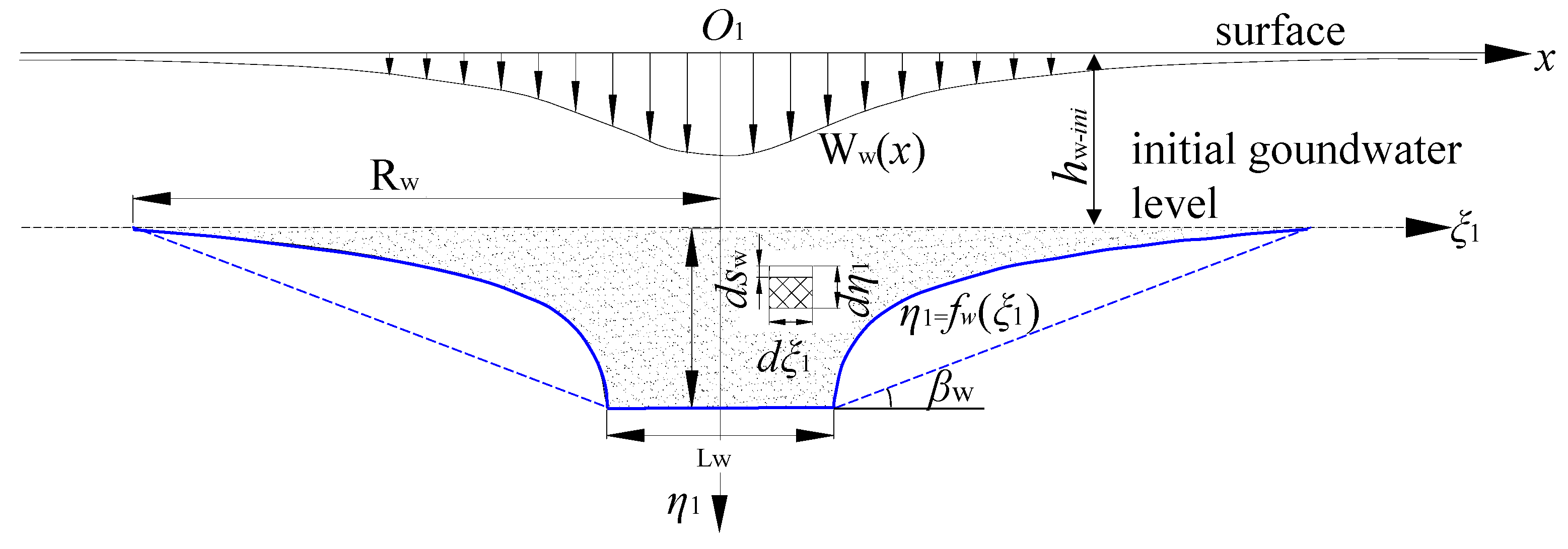
2.2. Surface Subsidence Prediction Model Considering the Single Effect of Loose Layer Drainage
2.2.1. The Characteristic Curve of the Groundwater Level Decline
2.2.2. Surface Subsidence Predicting Model Caused by Loose Layer Drainage in a Three-Dimensional Coordinate System
- (1)
- The integrand lacks an elementary function, necessitating the use of numerical integration methods for the solution.
- (2)
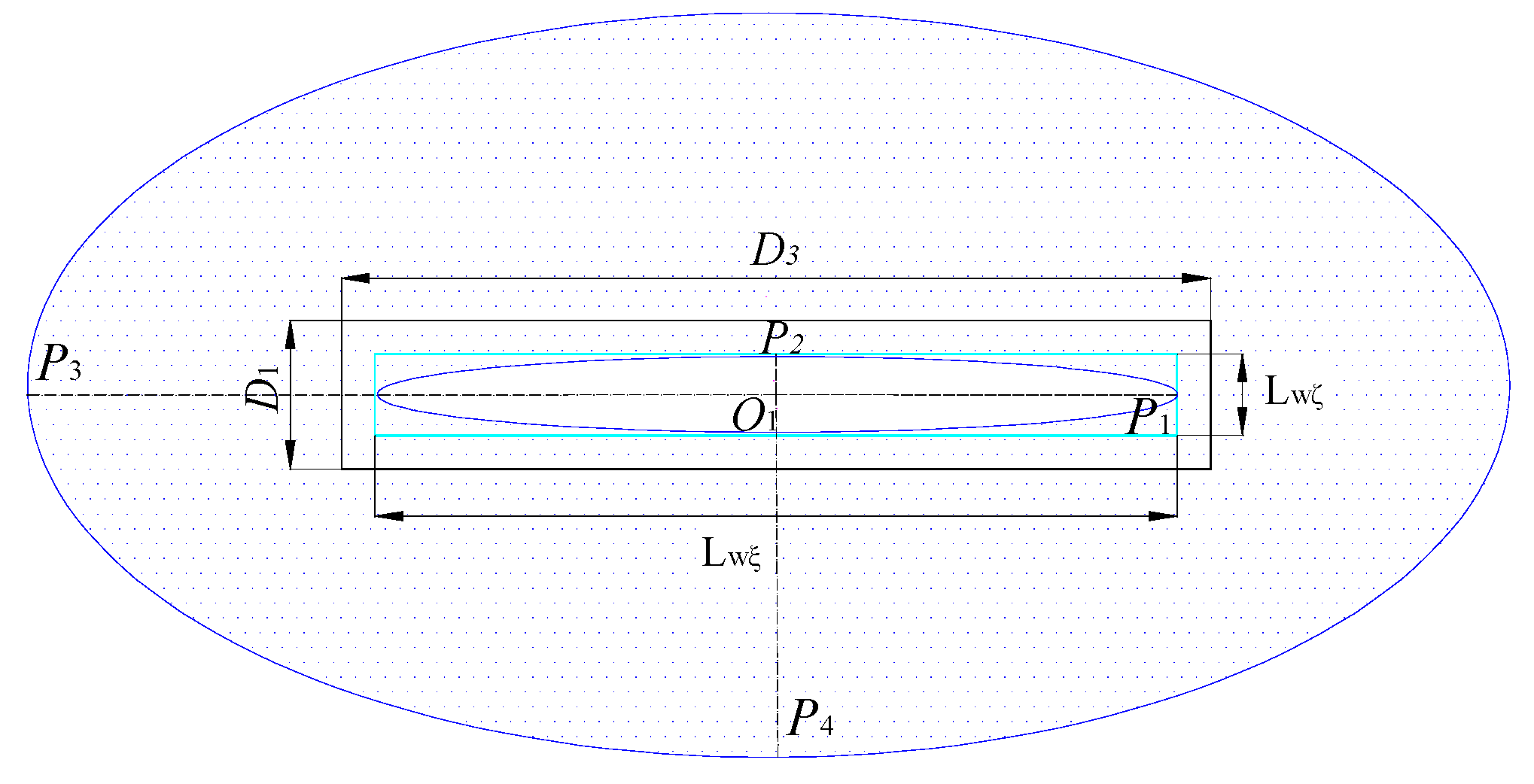
- In the ξ1O1ζ1 plane, the integration region is an ellipse, and the expression for ζ1 in terms of ξ1 is also complex due the complexity of the ellipse function in a Cartesian coordinate system.
- (3)
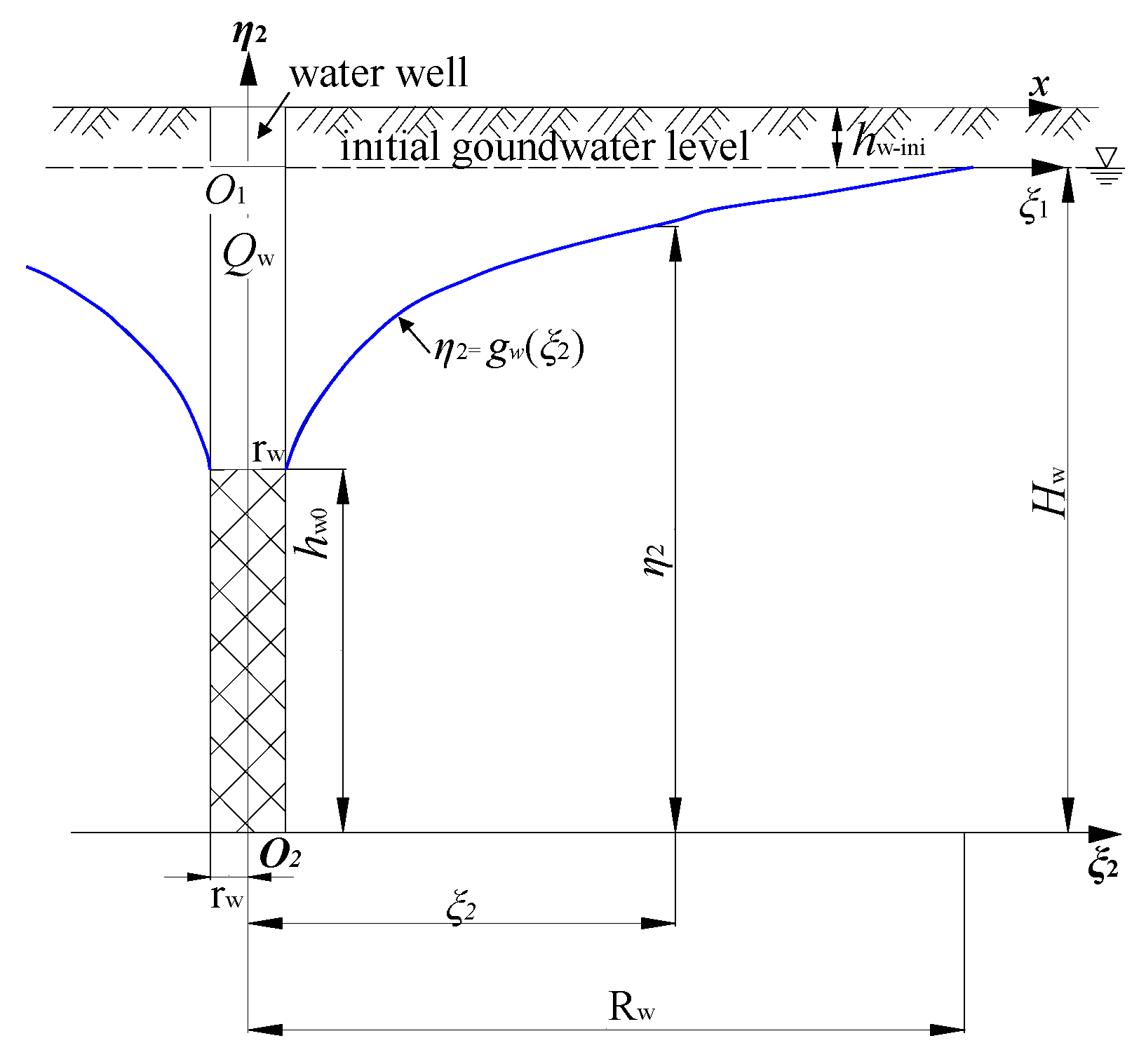
- In the ξ1O1η1 plane, η1 is a piecewise function of ξ1 (Equation (2)), and the expressions for the piecewise function are also complex (the first and third equations in Equation (2)). Now, in the O1ξ1ζ1η1 three-dimensional coordinate system, η1 is inevitably a piecewise function of both ξ1 and ζ1. Simultaneously, ζ1 is also a function of ξ1. More crucially, in the ξ1O1η1 or ζ1O1η1 plane, rw and Rw are constants, whereas in the O1ξ1ζ1η1 three-dimensional coordinate system, rw and Rw are variables in the region of integration which is a curved-edge elliptical frustum. Expressions representing the upper and lower limits of integration are difficult to represent explicitly using functional notation.
3. Background of the Study
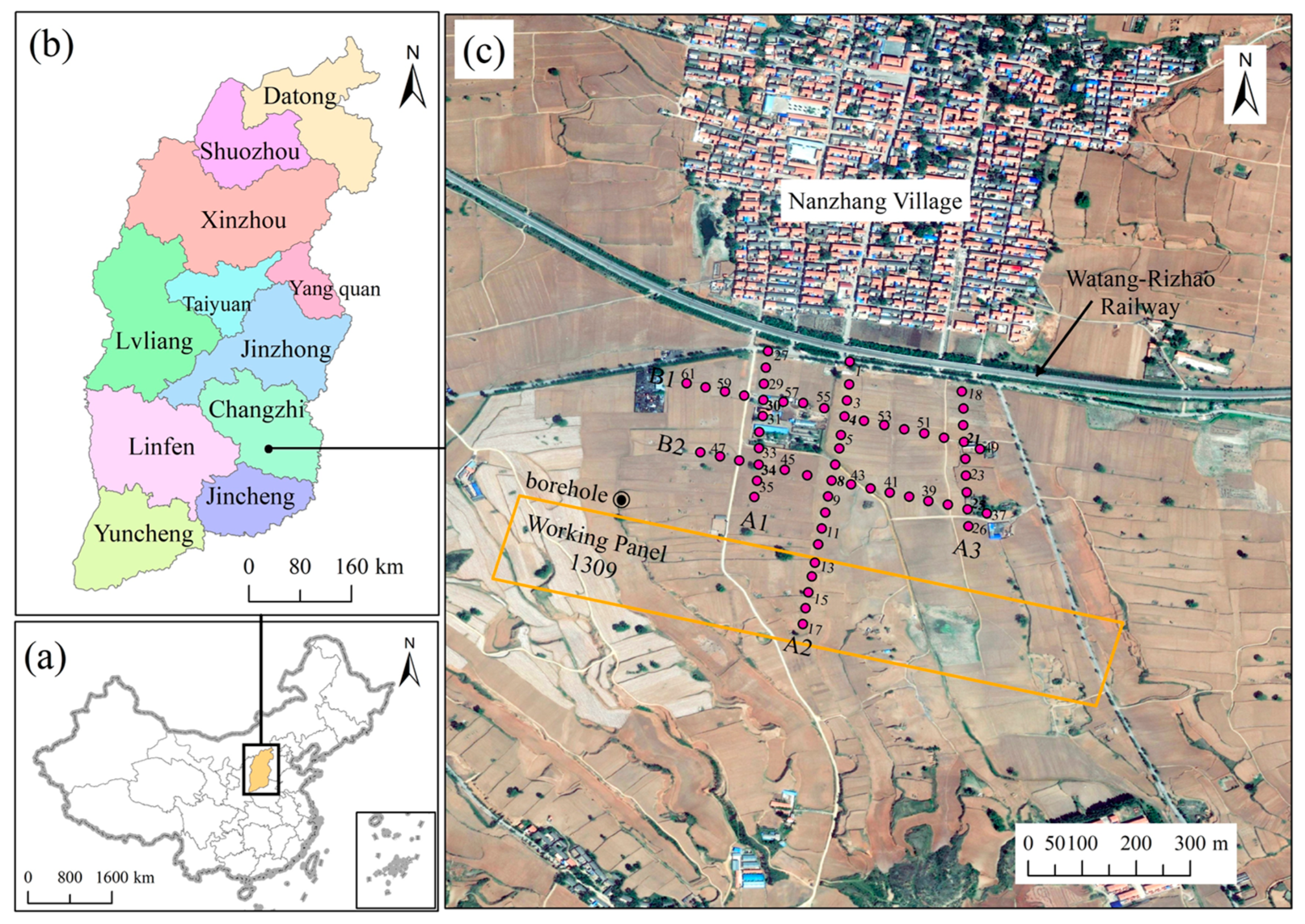
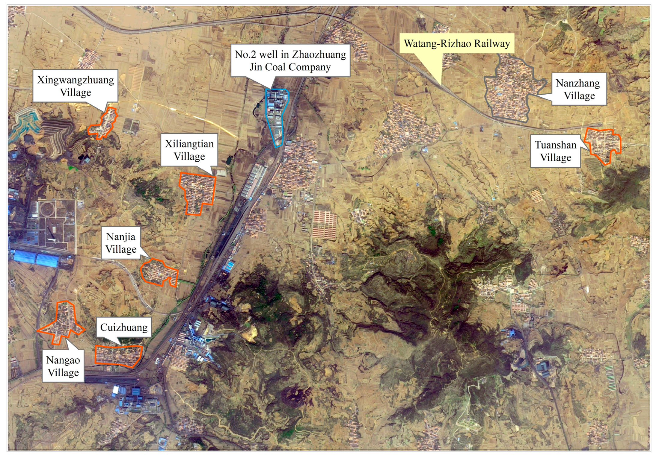
3.1. Study Area
3.2. The Engineering Geological Condition of Rock Strata
3.3. Layout of Observation Points and Observation Water Wells
3.4. The Geological Conditions of the Soil Layer
3.5. The Hydrological Conditions of Soil
4. Results and Discussion
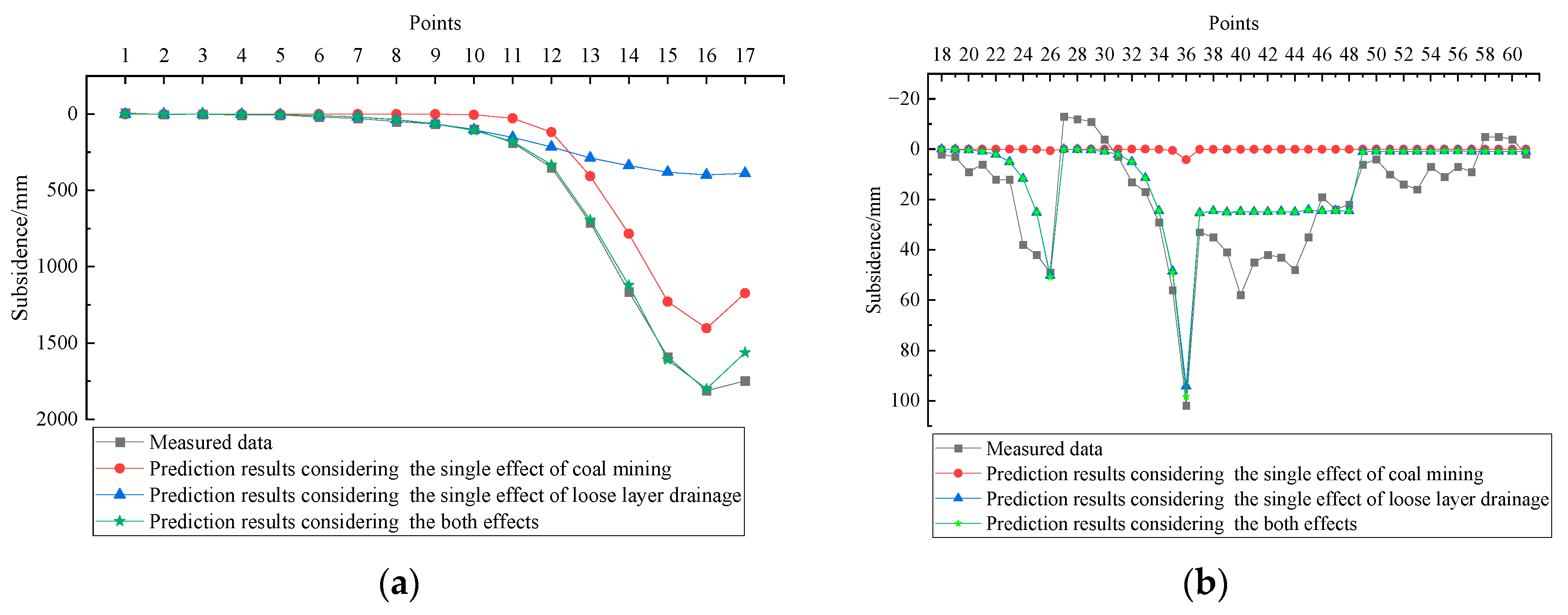
4.1. Validation of the Proposed Model Based on Measured Data
4.2. Validation of the Proposed Model Based on Numerical Simulation
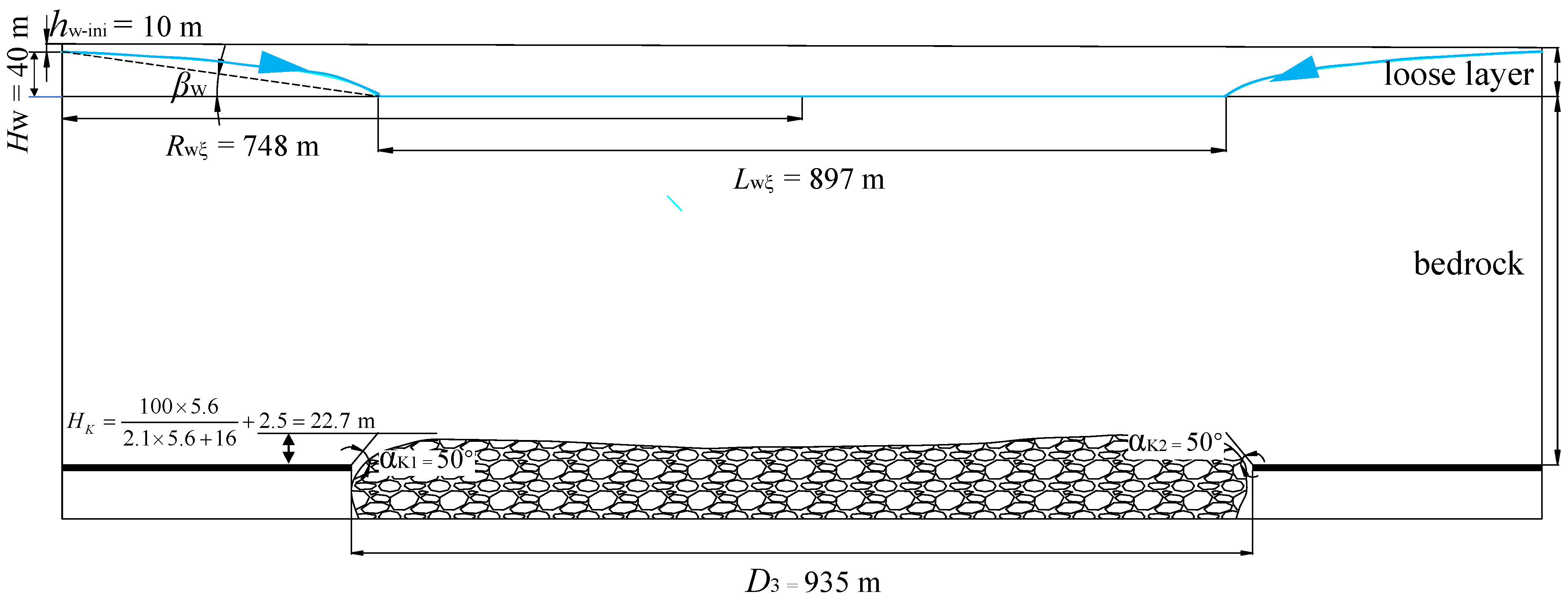
4.2.1. Establishment of the Numerical Model
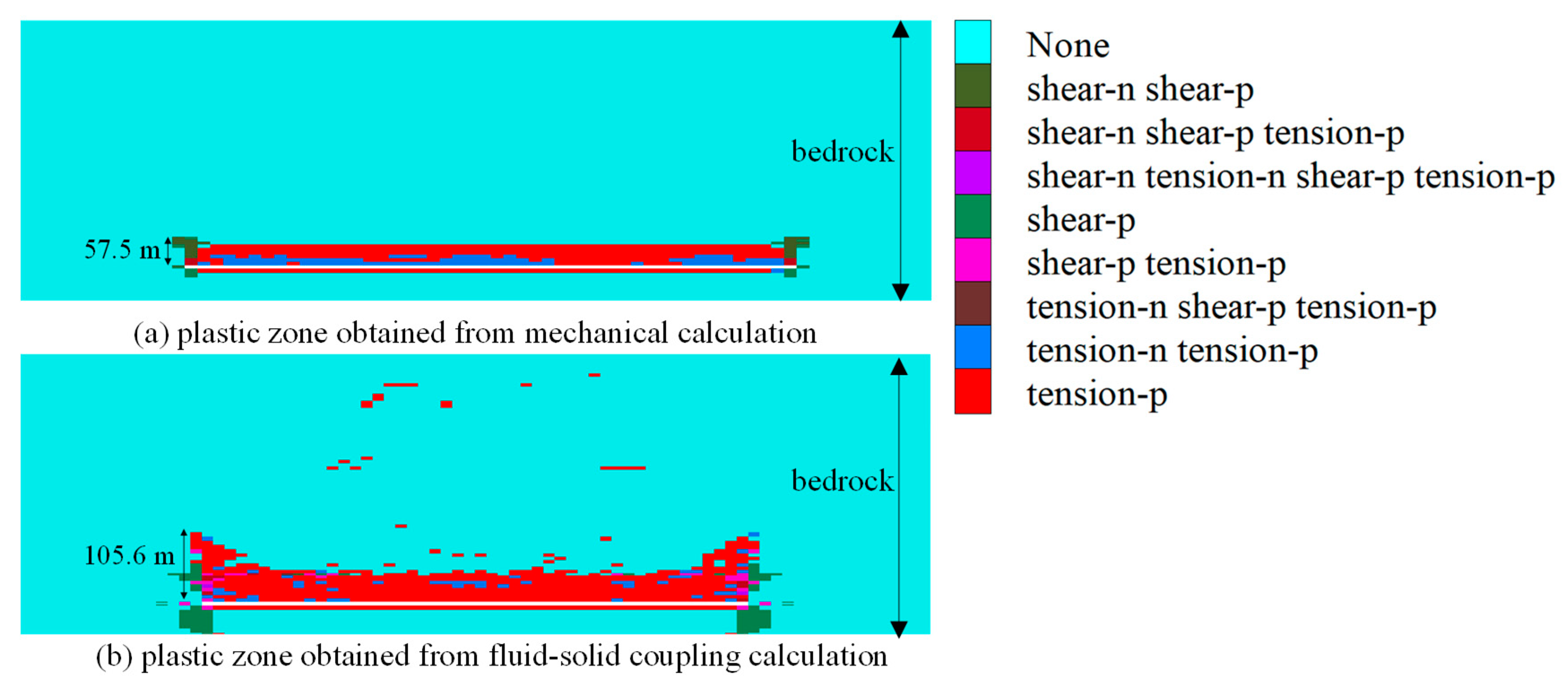
4.2.2. Analysis of Numerical Simulation Results
- (1)
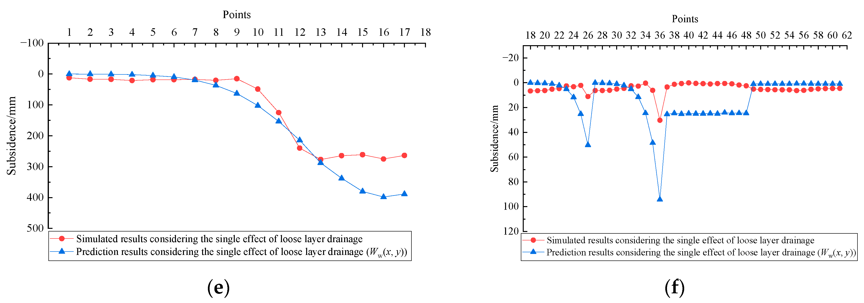
- Comparison of subsidence
- (2)
- Analysis of the spatial distribution characteristics of groundwater level decline
4.3. The Advantages of the Model Proposed in This Paper
5. Conclusions
Author Contributions
Funding
Data Availability Statement
Conflicts of Interest
Appendix A
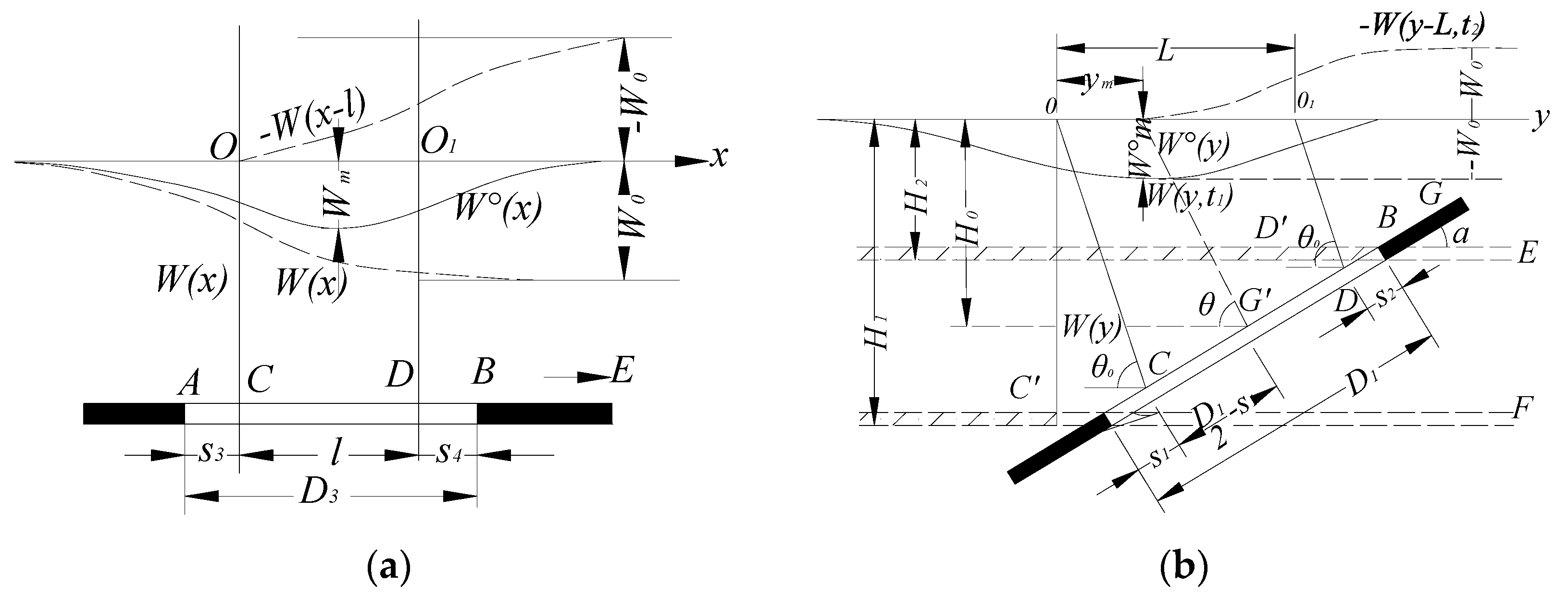
Appendix A.1. Definition of the Coordinate Systems
Appendix A.2. Expressions of PIM for a Rectangular Mining Area
Appendix A.3. Surface Subsidence Model Caused by Loose Layer Drainage in a Two-Dimensional Plane Condition
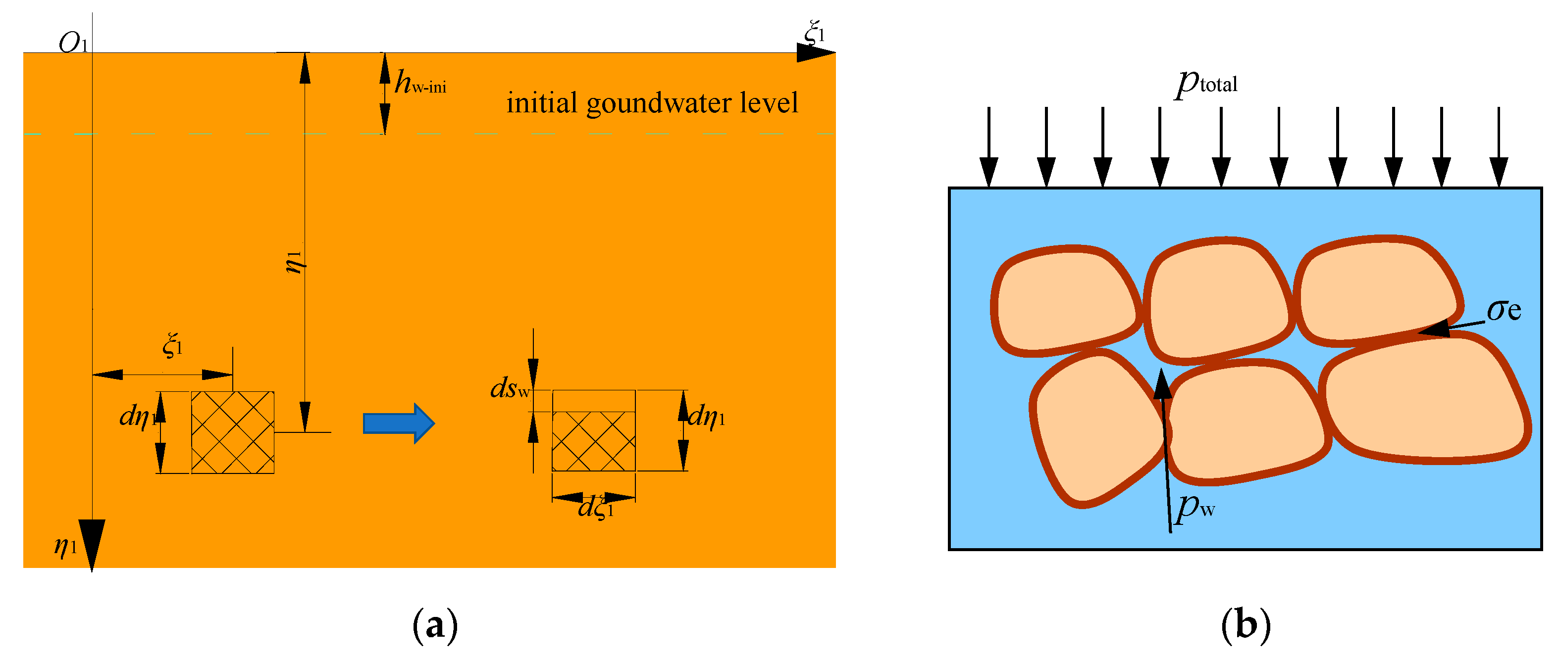
Appendix A.4. Solution for the Characteristic Curve of the Groundwater Level Decline
| Strata Lithology | Compressive Strength (σc, MPa) | Rock Property Constants | ||
|---|---|---|---|---|
| c1 | c2 | c3 | ||
| Strong and hard | 40~80 | 2.1 | 16 | 2.5 |
| Medium strong | 20~40 | 4.7 | 19 | 2.2 |
| Soft and weak | 10~20 | 6.2 | 32 | 1.5 |
| Extremely soft and weak | <10 | 7.0 | 63 | 1.2 |
- (1)
- The water flow in the aquifer obeys Darcy’s law.
- (2)
- The aquifer is a horizontally homogeneous and isotropic solid–liquid two-phase random medium.
- (3)
- The pore compression caused by soil drainage only occurs in the vertical direction.
- (4)
- The aquifer has the equal thickness in any position, and the groundwater surface before drainage is horizontal.
References
- Caputo, P.; Miriello, D.; Bloise, A.; Baldino, N.; Mileti, O.; Ranieri, G.A. A comparison and correlation between bitumen adhesion evaluation test methods, boiling and contact angle tests. Int. J. Adhes. Adhes. 2020, 102, 102680. [Google Scholar] [CrossRef]
- Jin, W.; Luo, Z.; Wu, X. Sensitivity analysis of related parameters in simulation of land subsidence and ground fissures caused by groundwater exploitation. B Eng. Geol. Environ. 2016, 75, 1143–1156. [Google Scholar] [CrossRef]
- Yang, X.; Wen, G.; Dai, L.; Sun, H.; Li, X. Ground subsidence and surface cracks evolution from shallow-buried close-distance multi-seam mining: A case study in Bulianta coal mine. Rock. Mech. Rock. Eng. 2019, 52, 2835–2852. [Google Scholar] [CrossRef]
- Liu, Z.; Mei, G.; Sun, Y.; Xu, N. Investigating mining-induced surface subsidence and potential damages based on SBAS-InSAR monitoring and GIS techniques: A case study. Environ. Earth Sci. 2021, 80, 817. [Google Scholar] [CrossRef]
- Bai, E.; Guo, W.; Tan, Y. Negative externalities of high-intensity mining and disaster prevention technology in China. B Eng. Geol. Environ. 2019, 78, 5219–5235. [Google Scholar] [CrossRef]
- Newman, C.; Agioutantis, Z.; Boede Jimenez Leon, G. Assessment of potential impacts to surface and subsurface water bodies due to longwall mining. Int. J. Min. Sci. Technol. 2017, 27, 57–64. [Google Scholar] [CrossRef]
- Chen, C.; Hu, Z.; Gao, Y.; Wang, Y.; Chen, Q.; Zhang, J.; Wang, G.; Kang, Y.; Liu, C.; Yang, F.; et al. Research progress in synergistic deformation between rock mass and soil due to underground coal mining in China. J. China Coal Soc. 2024, 1–24. [Google Scholar] [CrossRef]
- Guzy, A.; Witkowski, W.T. Land subsidence estimation for aquifer drainage induced by underground mining. Energies 2021, 14, 4658. [Google Scholar] [CrossRef]
- Xu, Y.; Geng, D.; Guan, Y.; Xu, F. Engineering Properties of Thick Alluvial Strata and Their Applications in Coal Mining Area; China Coal Industrial Publishing Press: Beijing, China, 2003. [Google Scholar]
- Booth, C.J. Groundwater as an environmental constraint of longwall coal mining. Environ. Geol. 2006, 49, 796–803. [Google Scholar] [CrossRef]
- Loupasakis, C.; Angelitsa, V.; Rozos, D.; Spanou, N. Mining geohazards-land subsidence caused by the dewatering of opencast coal mines: The case study of the Amyntaio coal mine, Florina, Greece. Nat. Hazards 2014, 70, 675–691. [Google Scholar] [CrossRef]
- Meng, S.; Wu, Q.; Zeng, Y.; Mei, A.; Yang, G.; Hua, Z.; Yang, L.; Zhang, Y. Evaluating the impact of coal seam roof groundwater using variable weights theory: A special emphasis on skylight-type water inrush pattern. J. Hydrol-Reg. Stud. 2024, 56, 102009. [Google Scholar] [CrossRef]
- Pan, Y.; Liu, Y.; Zeng, X.; Wu, J. Numerical simulation of groundwater flow field evolution in abandoned mine in the east Xuzhou. Hydrogeol. Eng. Geol. 2017, 44, 52–56. [Google Scholar]
- Younger, P.L.; Banwart, S.A.; Hedin, R.S.; Younger, P.L.; Banwart, S.A.; Hedin, R.S. Mine Water Hydrology; Springer: Berlin/Heidelberg, Germany, 2002. [Google Scholar]
- Harr, M.E. Groundwater and Seepage; Courier Corporation: North Chelmsford, MA, USA, 2012. [Google Scholar]
- Zhai, H.; Wang, J.; Lu, Y.; Rao, Z.; He, K.; Hao, S.; Huo, A.; Adnan, A. Prediction of the mine water inflow of coal-bearing rock series based on well group pumping. Water 2023, 15, 3680. [Google Scholar] [CrossRef]
- Chambers, J.E.; Meldrum, P.I.; Wilkinson, P.B.; Ward, W.; Jackson, C.; Matthews, B.; Joel, P.; Kuras, O.; Bai, L.; Uhlemann, S.; et al. Spatial monitoring of groundwater drawdown and rebound associated with quarry dewatering using automated time-lapse electrical resistivity tomography and distribution guided clustering. Eng. Geol. 2015, 193, 412–420. [Google Scholar] [CrossRef]
- Li, H.; Chen, L.; Zhang, F.; Li, B.; Chen, X. Variation characteristics of confined water flow field under the condition of laboratory simulation. Geotech. Investig. Surv. 2017, 45, 24–29. [Google Scholar]
- Khan, M.S.H.; Haque, M.E.; Ahmed, M.; Mallick, J.; Islam, A.R.M.T.; Fattah, M.A. Quantitative analysis and modeling of groundwater flow using visual MODFLOW: A case from subtropical coal mine, northwest Bangladesh. Environ. Dev. Sustain. 2024, 26, 12971–12993. [Google Scholar] [CrossRef]
- Liu, B.; Yang, J.; Zhang, J. Surface subsidence and deformation caused by open pit mining and de watering. J. China Coal Soc. 1999, 24, 41–44. [Google Scholar]
- Tang, F.; Bai, F. Calculation method of surface subsidence caused by water loss in thick loess mining area. J. Xi’an Univ. Sci. Technol. 2011, 31, 448–452. [Google Scholar]
- Yuan, H.; Lu, Z.; Lian, H.; Zhang, Y. Numerical simulation of ground movement law of fully mechanized caving mining under thick hydrous collapsed loess. Coal Sci. Technol. 2013, 41, 26–29. [Google Scholar]
- Li, C.; Guo, Z. Numerical analysis of water-bearing alluvium consolidation influence on surface subsidence. J. Henan Polytech. Univ. (Nat. Sci.) 2012, 31, 48–53. [Google Scholar]
- Li, C.; Liu, H.; Cui, X.; Che, Y. Characteristics and mechanism of alluvium settlement induced by underground coal extraction under the action of groundwater. J. China Univ. Min. Technol. 2019, 48, 221–228. [Google Scholar]
- Chen, Y.; Cheng, S. Study on surface subsidence resulting from the combined effects of coal mining and groundwater dewatering. Mine Surv. 2001, 9, 65–67. [Google Scholar]
- Zhou, D.; Wu, K.; Miao, X.; Li, L. Combined prediction model for mining subsidence in coal mining areas covered with thick alluvial soil layer. B Eng. Geol. Environ. 2018, 77, 283–304. [Google Scholar] [CrossRef]
- Tang, W.; Zhao, X.; Motagh, M.; Bi, G.; Li, J.; Chen, M.; Chen, H.; Liao, M. Land subsidence and rebound in the Taiyuan basin, northern China, in the context of inter-basin water transfer and groundwater management. Remote Sens. Environ. 2022, 269, 112792. [Google Scholar] [CrossRef]
- Ao, Z.; Hu, X.; Tao, S.; Hu, X.; Wang, G.; Li, M.; Wang, F.; Hu, L.; Liang, X.; Xiao, J.; et al. A national-scale assessment of land subsidence in China’s major cities. Science 2024, 384, 301–306. [Google Scholar] [CrossRef] [PubMed]
- He, G.; Yang, L.; Ling, G.; Jia, F.; Hong, D. Mining Subsidence Theory; China University of Mining and Technology Press: Xuzhou, China, 1991. [Google Scholar]
- Hu, B.; Zhang, H.; Shen, B. Regulations on Mining Under Buildings, Water Bodies and Railways and Coal Safety Pillars in Main Roadway; China Coal Industry Publishing Press: Beijing, China, 2018. [Google Scholar]
- Knothe, S. Observations of Surface Movements Under Influence of Mining and Their Theoretical Interpretation; University of Leeds: Leeds, UK, 1957; pp. 210–218. [Google Scholar]
- Malinowska, A.; Hejmanowski, R.; Dai, H. Ground movements modeling applying adjusted influence function. Int. J. Min. Sci. Technol. 2020, 30, 243–249. [Google Scholar] [CrossRef]
- Deng, K.; Tan, Z.; Jiang, Y.; Dai, H.; Xu, L. Deformation Monitoring and Mining Subsidence Engineering; China University of Mining and Technology Press: Xuzhou, China, 2014. [Google Scholar]
- Terzaghi, K.; Peck, R.B. Soil Mechanics in Engineering Practice; John Wiley and Sons, Inc.: New York, NY, USA, 1948. [Google Scholar]
- Peng, S.; Cheng, H.; Yao, Z.; Rong, C.; Cai, H.; Zhang, L. Study on prediction and characteristies of surface subsidence in mining when the bottom aquifer of thick loose layer directly covers thin bedrock. J. China Coal Soc. 2022, 47, 4417–4430. [Google Scholar]
- Chen, Y. Study on Surface Subsidence Resulting from the Combined Effects of Coal Mining and Groundwater Dewatering. Master’s Thesis, Shandong University of Science and Technology, Qingdao, China, 2002. [Google Scholar]
- Yuan, L. Scientific conception of precision coal mining. J. China Coal Soc. 2017, 42, 1–7. [Google Scholar]
- Ross, K.A. Elementary Analysis: The Theory of Calculus; Springer: Berlin/Heidelberg, Germany, 2013. [Google Scholar]
- Wang, K. Research on Influence Mechanism of Coal Mining in Thick Loess Region on The Overlying Loose Aquiter. Master’s Thesis, Taiyuan University of Technology, Taiyuan, China, 2016. [Google Scholar]
- The MathWorks, Inc. MATLAB Version: 9.13.0 (R2022b). Available online: https://www.mathworks.com (accessed on 24 August 2022).
- Itasca Consulting Group. Fast Lagrangian Analysis of Continua in 3 Dimensions (FLAC3D). In Version 6.0, User’s Guide; Itasca Consulting Group: Minneapolis, MN, USA, 2019. [Google Scholar]
- Li, H.; Zha, J.; Guo, G. A new dynamic prediction method for surface subsidence based on numerical model parameter sensitivity. J. Clean. Prod. 2019, 233, 1418–1424. [Google Scholar] [CrossRef]
- Weng, L.; Luan, H.; Luan, Y. A numerical approach considering mining-induced fracture weakening and goaf compaction on surface subsidence. Geotech. Geol. Eng. 2019, 37, 283–294. [Google Scholar] [CrossRef]
- Zhang, C.; Ren, Z.; Han, P.; He, X.; Chen, J.; Guo, L. Characteristic of the water-conducting fracture zone development in thick overburden working face with extra-large mining height in western mining area. J. Min. Sci. Technol. 2022, 7, 333–343. [Google Scholar]
- Zhang, K. Roof rock breaking characteristics of 3# coal seam and influence of roof aquifer on mining. Energy Conserv. 2019, 4, 40–42. [Google Scholar]
- Cui, X.; Fang, Z.; Zuo, H.; Li, H. De-watering effect of aquifer to surface subsidence. Coal Geol. Explor. 2000, 28, 47–48. [Google Scholar]
- Liang, Q.; Wen, X.; He, G.; Chen, Q.; Yang, J. Study on calculation methods for surface subsidence caused by water loss of clay. J. Min. Saf. Eng. 2007, 24, 105–108. [Google Scholar]
- Yu, G.; Zhang, C.; Pan, Y.; Liu, F.; Yuan, C. Space-time predicting model research of surface subsidence caused by groundwater exploitation. Rock. Soil. Mech. 2006, 27, 759–762. [Google Scholar]
- Guo, W.; Zhao, G.; Lou, G.; Wang, S. A new method of predicting the height of the fractured water-conducting zone due to high-intensity longwall coal mining in China. Rock. Mech. Rock. Eng. 2019, 52, 2789–2802. [Google Scholar] [CrossRef]
- Ju, J.; Li, Q.; Xu, J.; Wang, X.; Lou, J. Self-healing effect of water-conducting fractures due to water-rock interactions in undermined rock strata and its mechanisms. B Eng. Geol. Environ. 2020, 79, 287–297. [Google Scholar] [CrossRef]
- Wang, F.; Xu, J.; Chen, S.; Ren, M. Method to predict the height of the water conducting fractured zone based on bearing structures in the overlying strata. Mine Water Environ. 2019, 38, 767–779. [Google Scholar] [CrossRef]
- Li, T.; Song, H.; Huang, G.; Bi, Y.; Li, X. Assessment of groundwater changing trends through the generalized large well method with confined-unconfined flow model in open-pit mine area. Environ. Earth Sci. 2014, 72, 4599–4606. [Google Scholar] [CrossRef]
- Singh, S.K. Approximation of well function for large diameter wells. J. Irrig. Drain. Eng. 2007, 133, 414–416. [Google Scholar] [CrossRef]




| Mining Information | Values | |
|---|---|---|
| Dimensions | length | 935 m |
| width | 159 m | |
| Mining depth at each boundary | downhill | 417 m |
| uphill | 398 m | |
| open-off cut | 425 m | |
| stopping line | 390 m | |
| average mining depth | 408 m | |
| Average thickness of loose layer | 50 m | |
| Mining thickness of coal seam | 5.6 m | |
| Dip angle of coal seam | 3~10° | |
| Coal mining method | Medium-sized fully mechanized top-coal caving mining method | |
| Roof management method | Roof management by full caving method | |
| Mining period | March 2015–August 2016 | |
| Number of Water Wells | Villages | Depth of Well (m) | Ground Water Level Depth During Low Water Period (m) | Ground Water Level Depth During High Water Period (m) |
|---|---|---|---|---|
| #32 | Nanjia Village | 85 | 16 | 13.2 |
| #36 | Xitianliang Village | 35 | 5.2 | 4.8 |
| #37 | Xitianliang Village | 9 | 6.7 | 5.9 |
| #40 | Cui Zhuang | 30 | 8.9 | 7.3 |
| #42 | Nangao Village | 24 | 4.5 | 3.8 |
| #43 | Nangao Village | 15 | 2.8 | 2.3 |
| #44 | Nangao Village | 12 | 8.9 | 8.6 |
| #67 | Xingwangzhuang Village | 10 | 0.9 | 0.7 |
| #1 | Tuanshan village | 13 | 4.4 | 3.4 |
| #2 | Tuanshan village | 12 | 2.4 | 2.0 |
| #3 | Tuanshan village | 95 | 5.5 | 4.5 |
| #85 | Tuanshan village | 20 | 4.7 | 3.8 |
| Parameters | q | tanβ | θ0/° | s1/m | s2/m | s3/m | s4/m |
|---|---|---|---|---|---|---|---|
| Values | 0.59 | 2.6 | 83 | 35.9 | 35.9 | 35.9 | 35.9 |
| Measured data | (Wc) | (Ww) | (Wc + Ww) | |
|---|---|---|---|---|
| Points | Subsidence | |||
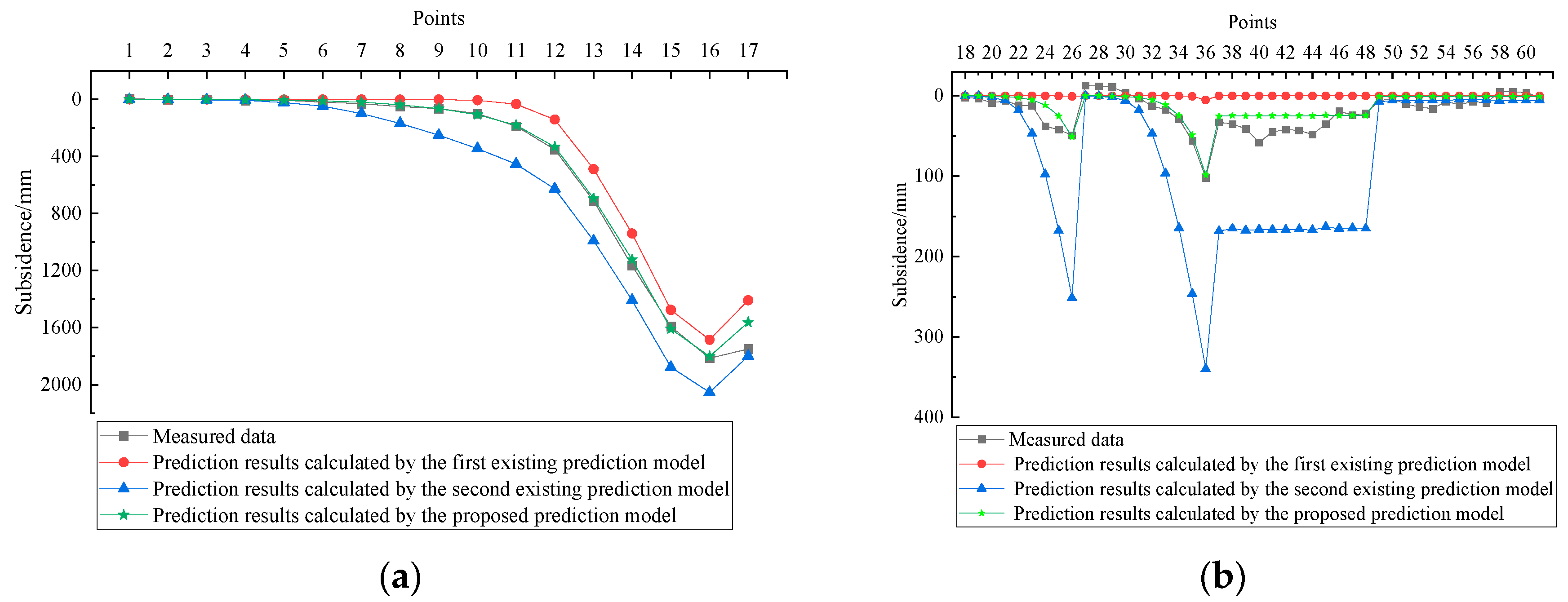
| No. 16 | 1813 mm | 1403 mm | 398 mm | 1801 mm |
| No. 26 | 49 mm | 0.5 mm | 50.3 mm | 50.8 mm |
| No. 36 | 102 mm | 4 mm | 94 mm | 98 mm |
| RMSE | 128 mm | 27 mm | ||
| Line | Distance from the 10 mm subsidence point to the boundary of working panel 1309 | |||
| A2 | 218 m | 70 m | 205 m | 205 m |
| Points | Measured Data | Considering the Single Effect of Coal Mining | Considering the Single effect of Loose Layer Drainage | Considering Both the Effects | |||
|---|---|---|---|---|---|---|---|
| Simulated results | Prediction results | Simulated results | Prediction results | Simulated results | Prediction results | ||
| No. 16 | 1813 mm | 1751 mm | 1403 mm | 1475 mm | 398 mm | 276 mm | 1801 mm |
| No. 26 | 49 mm | 47 mm | 0.5 mm | 36 mm | 50.3 mm | 11 mm | 50.8 mm |
| No. 36 | 102 mm | 99 mm | 4 mm | 68 mm | 94 mm | 31 mm | 98 mm |
Disclaimer/Publisher’s Note: The statements, opinions and data contained in all publications are solely those of the individual author(s) and contributor(s) and not of MDPI and/or the editor(s). MDPI and/or the editor(s) disclaim responsibility for any injury to people or property resulting from any ideas, methods, instructions or products referred to in the content. |
© 2025 by the authors. Licensee MDPI, Basel, Switzerland. This article is an open access article distributed under the terms and conditions of the Creative Commons Attribution (CC BY) license (https://creativecommons.org/licenses/by/4.0/).
Share and Cite
Zhou, B.; Yan, Y.; Li, M.; Li, S.; Zhao, C.; Kang, J.; Zhang, J. Integrating Loose Layer Drainage into Mining Subsidence Prediction: A Mathematical Model Validated by Field Measurements and Numerical Simulations. Water 2025, 17, 2687. https://doi.org/10.3390/w17182687
Zhou B, Yan Y, Li M, Li S, Zhao C, Kang J, Zhang J. Integrating Loose Layer Drainage into Mining Subsidence Prediction: A Mathematical Model Validated by Field Measurements and Numerical Simulations. Water. 2025; 17(18):2687. https://doi.org/10.3390/w17182687
Chicago/Turabian StyleZhou, Bang, Yueguan Yan, Ming Li, Shengcai Li, Chuanwu Zhao, Jianrong Kang, and Jinman Zhang. 2025. "Integrating Loose Layer Drainage into Mining Subsidence Prediction: A Mathematical Model Validated by Field Measurements and Numerical Simulations" Water 17, no. 18: 2687. https://doi.org/10.3390/w17182687
APA StyleZhou, B., Yan, Y., Li, M., Li, S., Zhao, C., Kang, J., & Zhang, J. (2025). Integrating Loose Layer Drainage into Mining Subsidence Prediction: A Mathematical Model Validated by Field Measurements and Numerical Simulations. Water, 17(18), 2687. https://doi.org/10.3390/w17182687


