Rapid Flood Mapping and Disaster Assessment Based on GEE Platform: Case Study of a Rainstorm from July to August 2024 in Liaoning Province, China
Abstract
1. Introduction
2. Materials and Methods
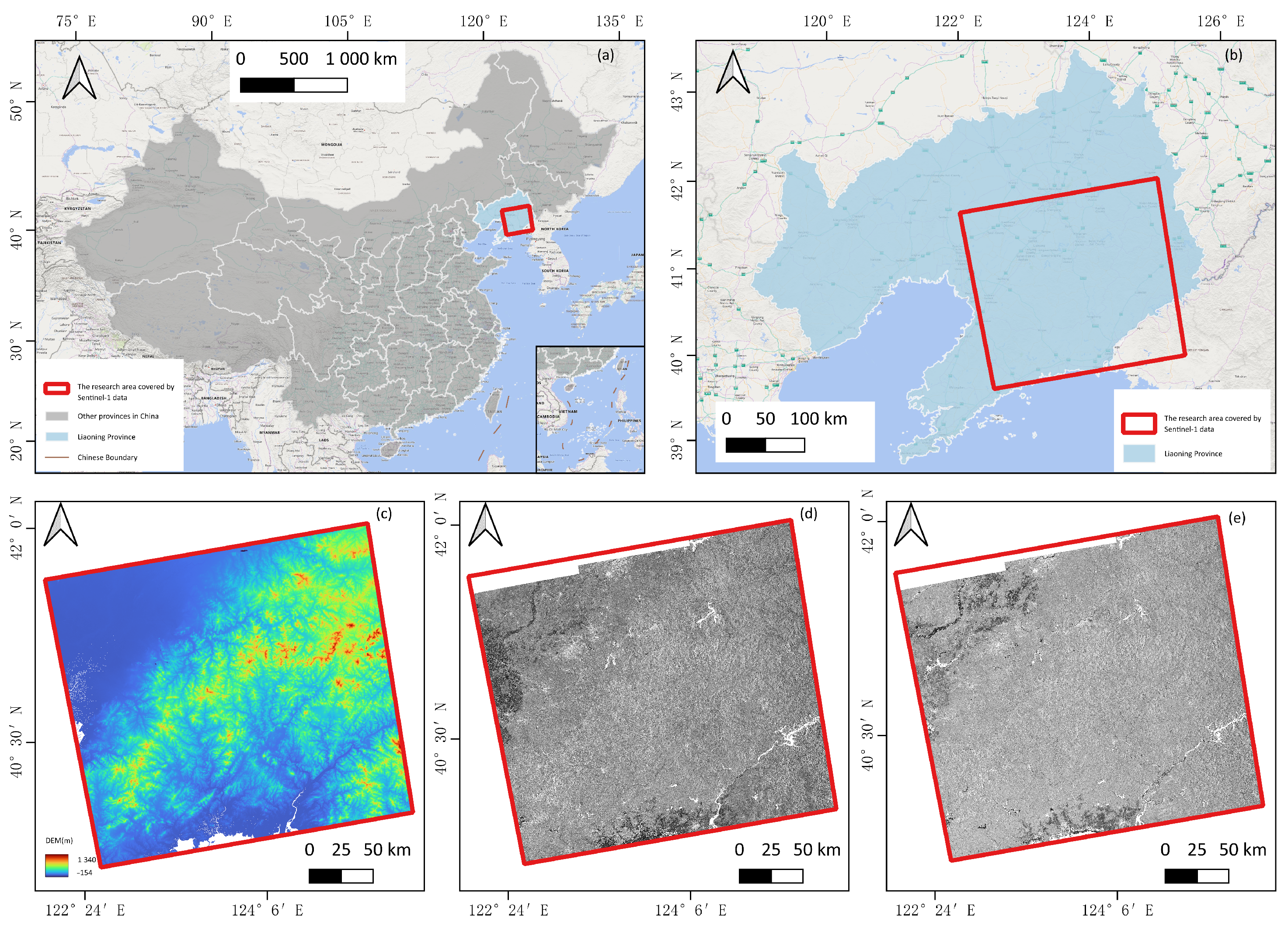
2.1. Study Area
2.2. Data Acquisition
2.2.1. Sentinel-1 SAR
2.2.2. Ancillary Datasets
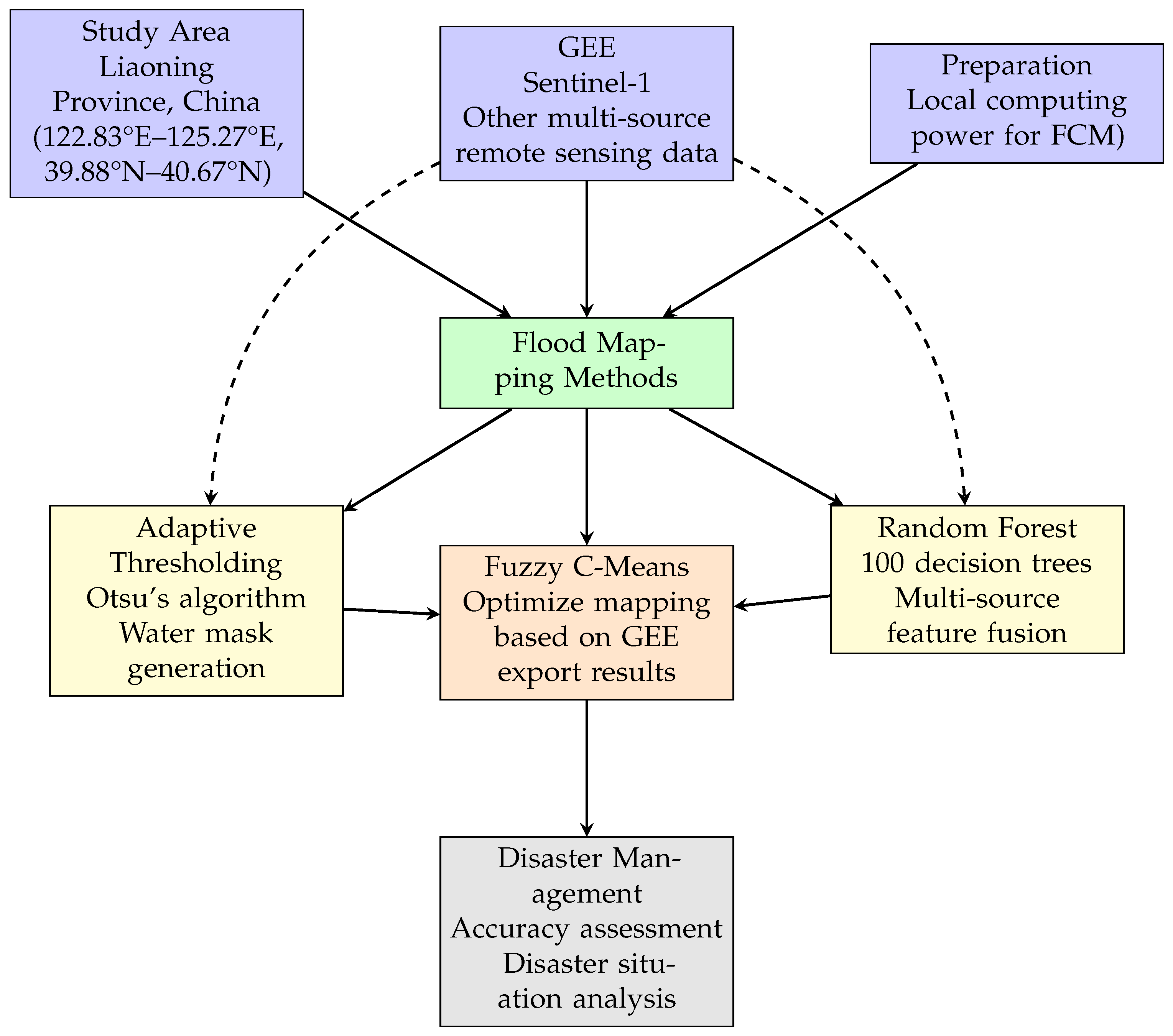
2.3. Overall Methodological Framework
2.4. Adaptive Water Thresholding
2.4.1. Algorithm Flow
- 1.
- Apply focal median filter to reduce speckle:where
- : original VV-polarized backscatter coefficient (dB);
- r: filter radius (50 m).
- 2.
- Compute backscatter histogram H over AOI (area of interest):
- 3.
- Determine optimal threshold , maximizing inter-class variance:where = class probability, = class mean.
- 4.
- Generate binary water mask:
2.4.2. Post-Processing
- 1.
- Water occurrence frequency:( retained as persistent water).
- 2.
- Slope-based water exclusion:where
- : original classification label;
- : adjusted classification label;
- : terrain slope angle (degrees);
- null: invalid classification flag.
- 3.
- Area quantification:where
- : area of class c in km2;
- c: land cover class index;
- : area of pixel i in m2;.
2.5. Random Forest Classification
2.5.1. Training Sample Generation
2.5.2. Feature Engineering
2.5.3. Construction of Random Forest Classifier
- 70/30 training–test split;
- Gini impurity splitting criterion;
- Maximum tree depth: unlimited.
2.6. Accuracy Assessment
- Thresholding method: Temporal consistency analysis.
- RF classification: Confusion matrix metrics:
- Visual validation with false-color composites;
- Statistical comparison against JRC reference.
2.7. Fuzzy C-Means Classification Framework
2.7.1. Mathematical Formulation
- n = Number of pixels in input data;
- c = Number of clusters (fixed at 5: Unclassified, non-water, high-scattering, permanent water, flood);
- = Membership degree of pixel i in cluster j ();
- m = Fuzziness exponent ( for this study);
- = Euclidean distance between feature vector and cluster centroid .
2.7.2. Feature Space Configuration
- = Post-event backscatter (dB);
- = Mean pre-event backscatter (dB);
- = Backscatter ratio;
- DEM = Elevation (m) from Copernicus DEM;
- Slope = Terrain gradient (°).
2.7.3. Topographic Integration
2.7.4. Algorithm Implementation
2.7.5. Probabilistic Refinement
- : class label of pixel i;
- : 8-neighbor system;
- : Kronecker delta function;
- : spatial regularization weight;
- : spectral fidelity weight;
- : centroid of class .
- Input files:
- –
- Post-event file: Geocoded backscatter coefficient (dB or unitless);
- –
- Pre-event file list: n pre-event images (multiple acquisitions recommended).
- Optional files:
- –
- DEM file: Copernicus DEM (COP-DEM) as ellipsoid reference;
- –
- Slope file: Terrain slope data for shadow reduction.
- Threshold parameters:
- –
- Water threshold: dB (minimum backscatter for water detection);
- –
- DEM threshold: (maximum elevation for flood consideration);
- –
- Slope threshold: (terrain slope limit for false-positive reduction);
- –
- Ratio threshold: Minimum pre/post backscatter ratio for flood detection;
- –
- High scattering point: dB (vessel/urban area exclusion).
- Output products:
- –
- _class: classification raster;
- –
- _postEvent: post-event mean intensity;
- –
- _preEvent: pre-event mean intensity;
- –
- _ratio: backscatter ratio image.
3. Results
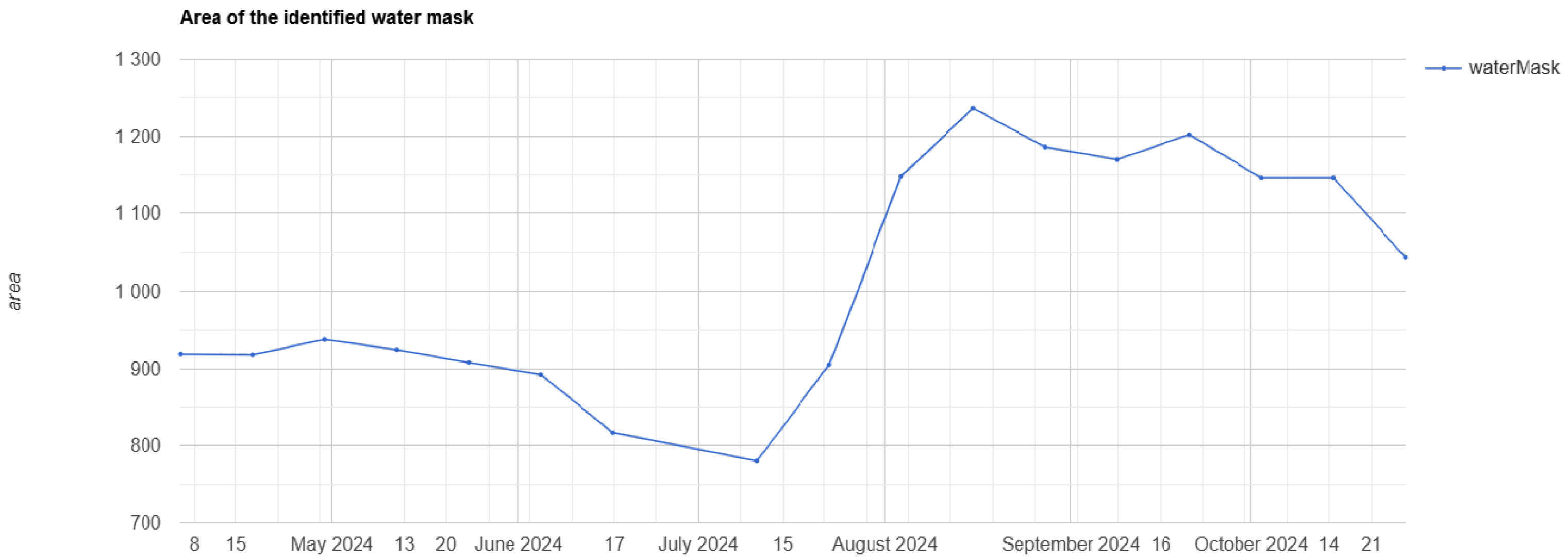
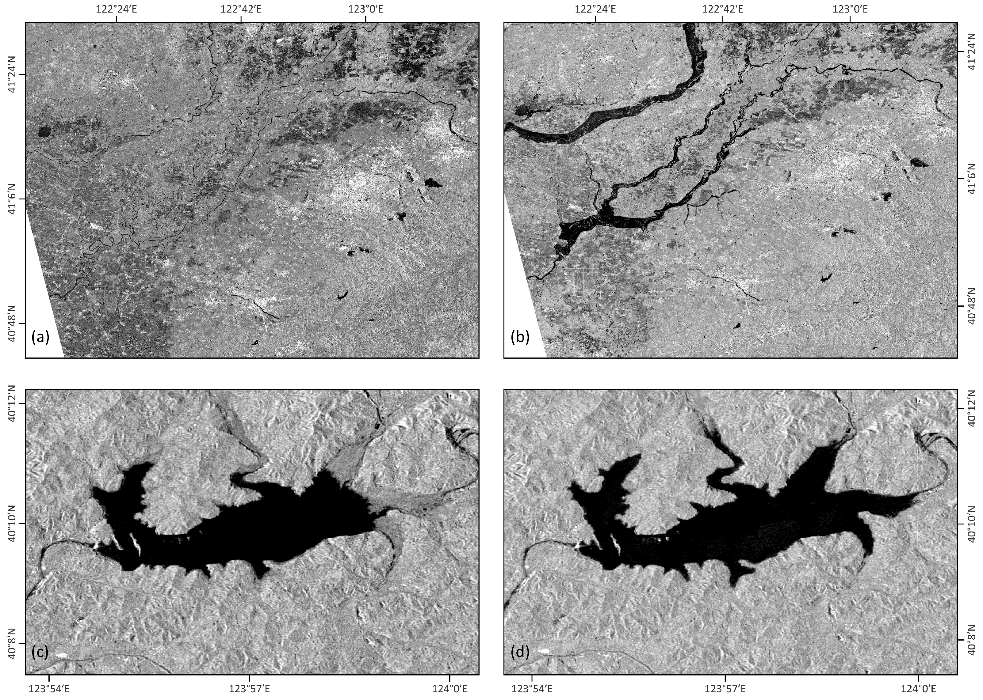
3.1. Otsu Method
- 1.
- Post-snowmelt decline (1 April–10 July 10): Water mask area decreased from to (−12.5%), attributed to the following:
- Exhaustion of snowmelt contributions from eastern Liaoning mountains;
- Agricultural water extraction for rice transplantation.
- 2.
- Rapid flood onset (10 July–3 August): A surge from (10 July) to 1148 (3 August) (+47.1%) was driven by the following:
- Convective storms during 10–15 July;
- Typhoon remnant rainfall;
- Reservoir emergency spillway activation.
- 3.
- Peak inundation (3–15 August): Maximum extent reached (15 August), representing a 58.4% increase from the June minimum. This plateau resulted from the following:
- Sustained precipitation;
- Saturated soil conditions reducing infiltration.
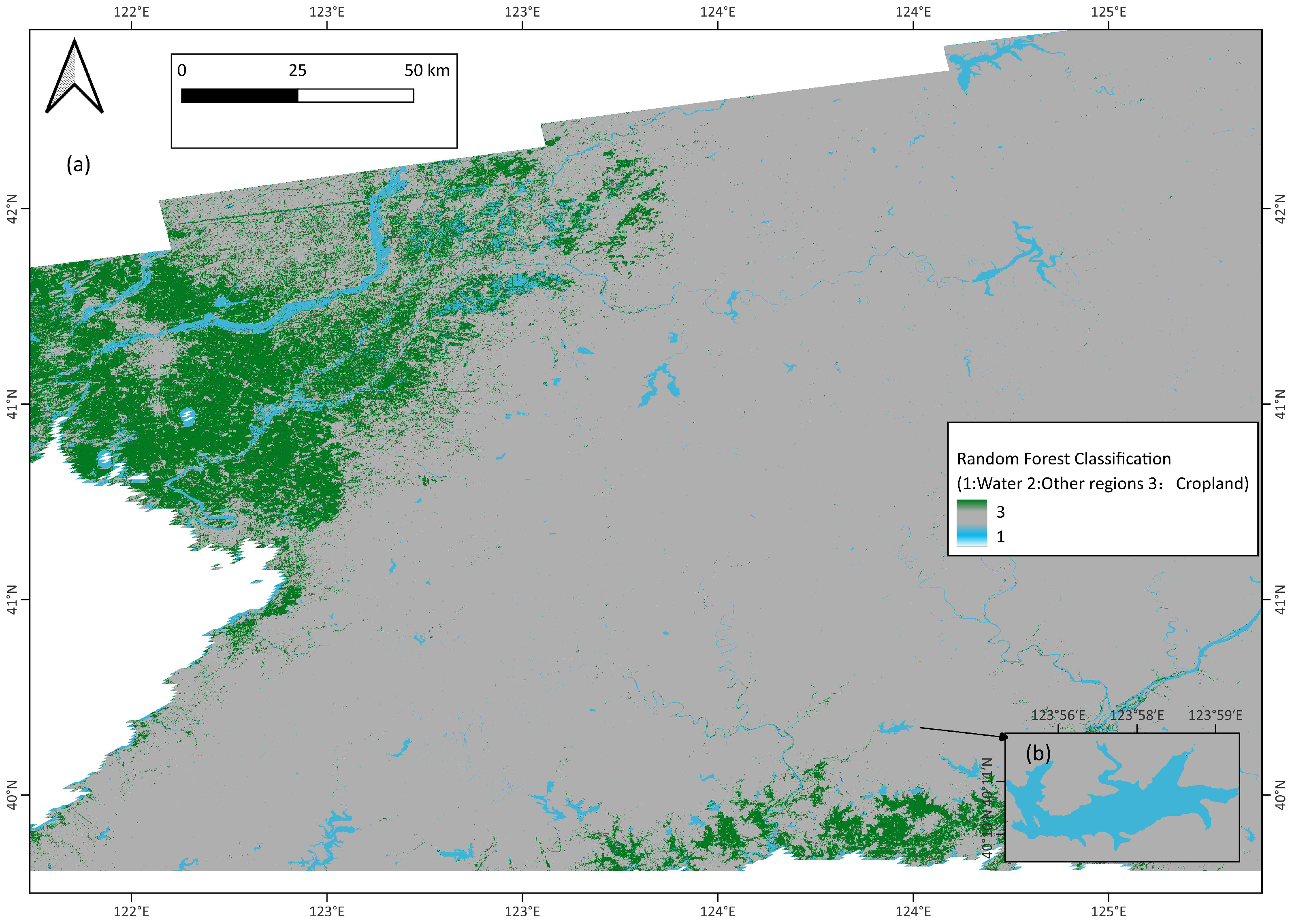
3.2. Random Forest Classification
Feature Importance Analysis
3.3. Error Analysis and Improvement Thinking
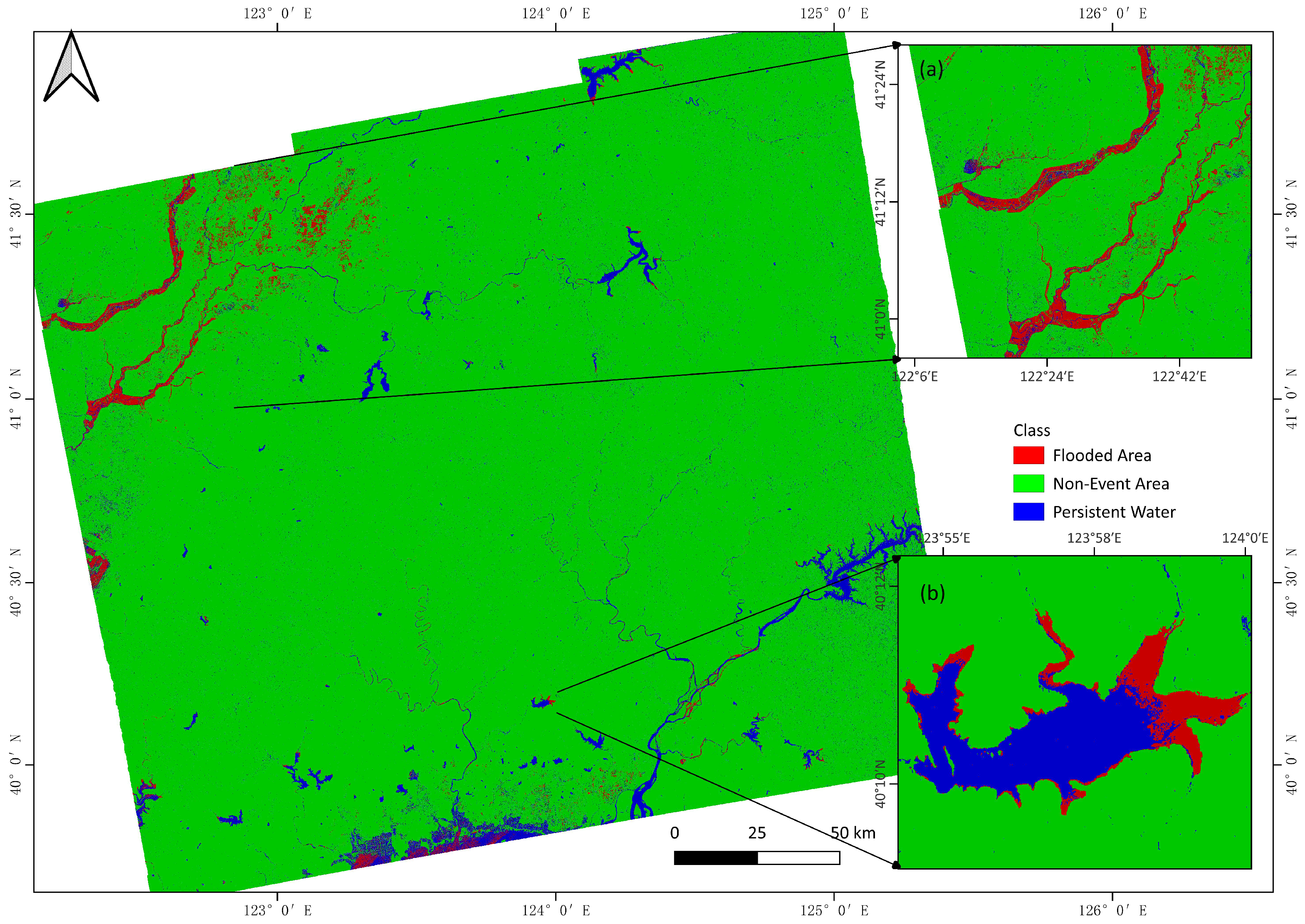
3.4. Fuzzy C-Means
3.4.1. Hydrological System Response
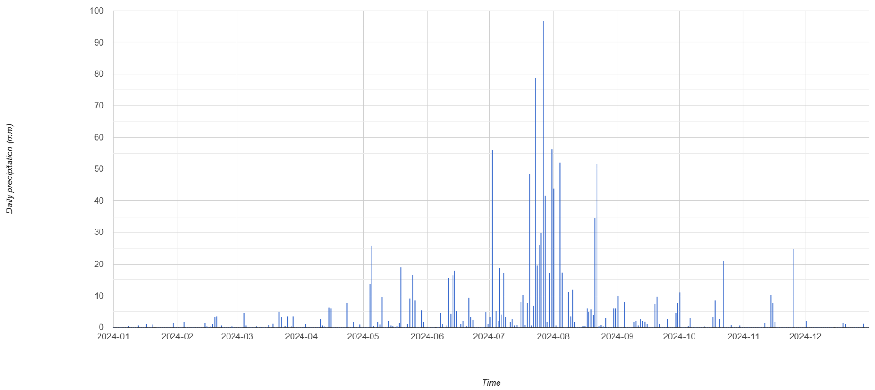
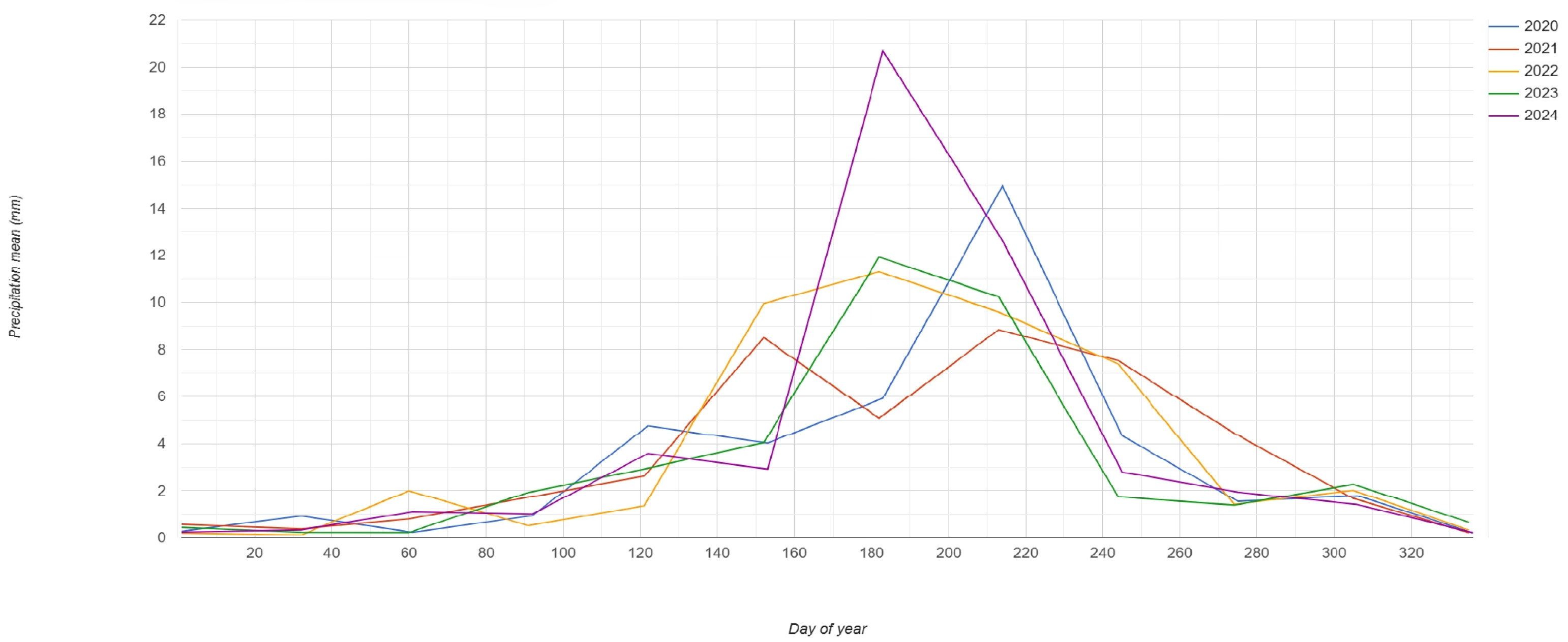
3.4.2. Meteorological Drivers and Precipitation Magnitude
4. Discussion
4.1. Limitations and Future Research
- 1.
- Temporal resolution: Sentinel-1’s 6-day revisit cycle missed peak flood transitions during rapid-onset events. Future work should integrate COSMO-SkyMed (<1 day revisit) for critical phases.
- 2.
- Vegetation penetration: C-band limitations in dense vegetation caused omission errors in riparian forests. L-band systems (e.g., ALOS-2) should be tested.
- 3.
- Real-time integration: Current processing lags hinder operational response. Edge computing implementations on UAV-SAR platforms could bridge this gap.
- 4.
- Feature engineering limitations: The random forest feature space showed seasonal sensitivity, requiring manual recalibration corresponding conditions.
- 5.
- GEE platform: While augmenting training samples or input features is a primary strategy for enhancing classification accuracy, practical computational constraints often limit the feasible scale. Consequently, complex machine learning or deep learning algorithms requiring extensive training datasets or longer training times that cannot be executed within environments like Google Earth Engine (GEE) [40,41]. Users must use external computing resources to implement such algorithms and apply more complex algorithms [42]. This further proves the necessity of the multi-pronged strategy of using cloud platforms and local computing power in this study.
4.2. Implications for Flood Risk Management
- High-recurrence zones (>10% frequency) require strategic relocation;
- Reservoir operation rules should incorporate backscatter-based early-warning thresholds.
5. Conclusions
Author Contributions
Funding
Data Availability Statement
Acknowledgments
Conflicts of Interest
References
- Lazin, R.; Pallotta, G.; Bonfils, C. Basin-informed flood frequency analysis using deep learning exhibits consistent projected regional patterns over CONUS. Sci. Rep. 2025, 15, 12754. [Google Scholar] [CrossRef]
- Kundzewicz, Z.W.; Kanae, S.; Seneviratne, S.I.; Handmer, J.; Nicholls, N.; Peduzzi, P.; Mechler, R.; Bouwer, L.M.; Arnell, N.; Mach, K. Flood Risk and Climate Change: Global and Regional Perspectives. Hydrol. Sci. J. 2014, 59, 1–28. [Google Scholar] [CrossRef]
- Taye, M.T.; Dyer, E. Hydrologic Extremes in a Changing Climate: A Review of Extremes in East Africa. Curr. Clim. Change Rep. 2024, 10, 1–11. [Google Scholar] [CrossRef]
- Kwakye, S.O.; Bárdossy, A. Quantification of the Hydrological Consequences of Climate Change in a Typical West African Catchment Using Flow Duration Curves. J. Water Clim. Change 2022, 13, 26–42. [Google Scholar] [CrossRef]
- United States Environmental Protection Agency (EPA). Climate Change Indicators: River Flooding; Technical report; U.S. Environmental Protection Agency: Washington, DC, USA, 2021. [Google Scholar]
- IPCC. Summary for Policymakers. In Climate Change 2022: Impacts, Adaptation and Vulnerability; Pörtner, H.O., Roberts, D.C., Poloczanska, E.S., Mintenbeck, K., Tignor, M., Alegría, A., Craig, M., Langsdorf, S., Löschke, S., Möller, V., et al., Eds.; Cambridge University Press: Cambridge, UK; New York, NY, USA, 2022; pp. 3–33. [Google Scholar] [CrossRef]
- Pandey, A.C.; Kaushik, K.; Parida, B.R. Google Earth Engine for Large-Scale Flood Mapping Using SAR Data and Impact Assessment on Agriculture and Population of Ganga-Brahmaputra Basin. Sustainability 2022, 14, 4210. [Google Scholar] [CrossRef]
- Ulloa, N.I.; Yun, S.H.; Chiang, S.H.; Furuta, R. Sentinel-1 Spatiotemporal Simulation Using Convolutional LSTM for Flood Mapping. Remote Sens. 2022, 14, 246. [Google Scholar] [CrossRef]
- Mustafa, A.R.A.; Shokr, M.S.; Alharbi, T.; Abdelsamie, E.A.; El-Sorogy, A.S.; Meroño de Larriva, J.E. Integration of Google Earth Engine and Aggregated Air Quality Index for Monitoring and Mapping the Spatio-Temporal Air Quality to Improve Environmental Sustainability in Arid Regions. Sustainability 2025, 17, 3450. [Google Scholar] [CrossRef]
- Carrasco Baquero, J.C.; Carrasco López, D.C.; Córdova Lliquín, J.D.; Guzmán Guaraca, A.C.; León Gualán, D.A.; Parra León, V.J.; Caballero Serrano, V.L. Multitemporal Analysis Using Remote Sensing and GIS to Monitor Wetlands Changes and Degradation in the Central Andes of Ecuador (Period 1986–2022). Resources 2025, 14, 61. [Google Scholar] [CrossRef]
- Ouled Sghaier, M.; Hammami, I.; Foucher, S.; Lepage, R. Flood Extent Mapping from Time-Series SAR Images Based on Texture Analysis and Data Fusion. Remote Sens. 2018, 10, 237. [Google Scholar] [CrossRef]
- Tiwari, V.; Kumar, V.; Matin, M.A.; Thapa, A.; Ellenburg, W.L.; Gupta, N.; Thapa, S. Flood Inundation Mapping-Kerala 2018; Harnessing the Power of SAR, Automatic Threshold Detection Method and Google Earth Engine. PLoS ONE 2020, 15, e0237324. [Google Scholar] [CrossRef]
- Zeng, H.; Jia, G.; Epstein, H. Recent Changes in Phenology over the Northern High Latitudes Detected from Multi-Satellite Data. Environ. Res. Lett. 2011, 6, 045508. [Google Scholar] [CrossRef]
- Rahman, M.S.; Di, L.; Yu, E.; Lin, L.; Yu, Z. Remote Sensing Based Rapid Assessment of Flood Crop Damage Using Novel Disaster Vegetation Damage Index (DVDI). Int. J. Disaster Risk Sci. 2020, 12, 90–110. [Google Scholar] [CrossRef]
- Qamer, F.M.; Abbas, S.; Ahmad, B.; Hussain, A.; Salman, A.; Muhammad, S.; Nawaz, M.; Shrestha, S.; Iqbal, B.; Thapa, S. A Framework for Multi-Sensor Satellite Data to Evaluate Crop Production Losses: The Case Study of 2022 Pakistan Floods. Sci. Rep. 2023, 13, 4240. [Google Scholar] [CrossRef]
- Laassilia, O.; Saghiry, S.; Ouazar, D.; Bouziane, A.; Hasnaoui, M.D. Flood Forecasting with a Dam Watershed Event-Based Hydrological Model in a Semi-Arid Context: Case Study in Morocco. Water Pract. Technol. 2022, 17, 817–834. [Google Scholar] [CrossRef]
- Kumar, V.; Yadav, S.M. Multi-Objective Reservoir Operation of the Ukai Reservoir System Using an Improved Jaya Algorithm. Water Supply 2022, 22, 2287–2310. [Google Scholar] [CrossRef]
- Choong, S.M.; El-Shafie, A.; Wan Mohtar, W.H.M. Optimisation of Multiple Hydropower Reservoir Operation Using Artificial Bee Colony Algorithm. Water Resour. Manag. 2017, 31, 1397–1411. [Google Scholar] [CrossRef]
- Gorelick, N.; Hancher, M.; Dixon, M.; Ilyushchenko, S.; Thau, D.; Moore, R. Google Earth Engine: Planetary-Scale Geospatial Analysis for Everyone. Remote Sens. Environ. 2017, 202, 18–27. [Google Scholar] [CrossRef]
- Bentivoglio, R.; Isufi, E.; Jonkman, S.N.; Taormina, R. Deep Learning Methods for Flood Mapping: A Review of Existing Applications and Future Research Directions. Hydrol. Earth Syst. Sci. 2022, 26, 4345–4378. [Google Scholar] [CrossRef]
- Otsu, N. A Threshold Selection Method from Gray-Level Histograms. IEEE Trans. Syst. Man Cybern. 1979, 9, 62–66. [Google Scholar] [CrossRef]
- Amani, M.; Ghorbanian, A.; Ahmadi, S.A.; Kakooei, M.; Moghimi, A.; Mirmazloumi, S.M.; Moghaddam, S.H.A.; Mahdavi, S.; Ghahremanloo, M.; Parsian, S.; et al. Google Earth Engine Cloud Computing Platform for Remote Sensing Big Data Applications: A Comprehensive Review. IEEE J. Sel. Top. Appl. Earth Obs. Remote Sens. 2020, 13, 5326–5350. [Google Scholar] [CrossRef]
- Munawar, H.S.; Hammad, A.W.A.; Waller, S.T. Remote Sensing Methods for Flood Prediction: A Review. Sensors 2022, 22, 960. [Google Scholar] [CrossRef]
- Koo, Y.; Xie, H.; Mahmoud, H.; Iqrah, J.M.; Ackley, S.F. Automated Detection and Tracking of Medium-Large Icebergs from Sentinel-1 Imagery Using Google Earth Engine. Remote Sens. Environ. 2023, 296, 113731. [Google Scholar] [CrossRef]
- Sun, X.; Li, L.; Zhang, B.; Chen, D.; Gao, L. Soft Urban Water Cover Extraction Using Mixed Training Samples and Support Vector Machines. Int. J. Remote Sens. 2015, 36, 3331–3344. [Google Scholar] [CrossRef]
- Skakun, S. A Neural Network Approach to Flood Mapping Using Satellite Imagery. Comput. Inform. 2012, 29, 1013–1024. [Google Scholar]
- Zhang, H.; Shi, W.; Hao, M.; Li, Z.; Wang, Y. An Adaptive Spatially Constrained Fuzzy C-Means Algorithm for Multispectral Remotely Sensed Imagery Clustering. Int. J. Remote Sens. 2017, 39, 2207–2237. [Google Scholar] [CrossRef]
- Ahmed, M.N.; Yamany, S.M.; Mohamed, N.; Farag, A.A.; Moriarty, T. A Modified Fuzzy C-Means Algorithm for Bias Field Estimation and Segmentation of MRI Data. IEEE Trans. Med. Imaging 2002, 21, 193–199. [Google Scholar] [CrossRef] [PubMed]
- Saxena, A.; Prasad, M.; Gupta, A.; Bharill, N.; Patel, O.P.; Tiwari, A.; Er, M.J.; Ding, W.; Lin, C.T. A Review of Clustering Techniques and Developments. Neurocomputing 2017, 267, 664–681. [Google Scholar] [CrossRef]
- Gong, M.; Zhou, Z.; Ma, J. Change Detection in Synthetic Aperture Radar Images Based on Image Fusion and Fuzzy Clustering. IEEE Trans. Image Process. 2012, 21, 2141–2151. [Google Scholar] [CrossRef] [PubMed]
- Bezdek, J.C.; Ehrlich, R.; Full, W. FCM: The Fuzzy C-Means Clustering Algorithm. Comput. Geosci. 1984, 10, 191–203. [Google Scholar] [CrossRef]
- Giustarini, L.; Hostache, R.; Matgen, P.; Schumann, G.J.P.; Bates, P.D.; Mason, D.C. A Change Detection Approach to Flood Mapping in Urban Areas Using TerraSAR-X. IEEE Trans. Geosci. Remote Sens. 2013, 51, 2417–2430. [Google Scholar] [CrossRef]
- Farhadi, H.; Kiani, A.; Ebadi, H.; Asgary, A. Development of an Automatic Time-Series Flood Mapping Framework Using Sentinel-1 and 2 Imagery. Stoch. Environ. Res. Risk Assess. 2025, 39, 2627–2655. [Google Scholar] [CrossRef]
- Liang, J.; Liu, D. A Local Thresholding Approach to Flood Water Delineation Using Sentinel-1 SAR Imagery. ISPRS J. Photogramm. Remote Sens. 2020, 159, 53–62. [Google Scholar] [CrossRef]
- Zeng, Z.; Gan, Y.; Kettner, A.; Yang, Q.; Zeng, C.; Brakenridge, G.R.; Hong, Y. Towards High Resolution Flood Monitoring: An Integrated Methodology Using Passive Microwave Brightness Temperatures and Sentinel Synthetic Aperture Radar Imagery. J. Hydrol. 2020, 582, 124377. [Google Scholar] [CrossRef]
- Moharrami, M.; Javanbakht, M.; Attarchi, S. Automatic Flood Detection Using Sentinel-1 Images on the Google Earth Engine. Environ. Monit. Assess. 2021, 193, 248. [Google Scholar] [CrossRef]
- Li, S.; Song, K.; Wang, S.; Liu, G.; Wen, Z.; Shang, Y.; Lyu, L.; Chen, F.; Xu, S.; Tao, H.; et al. Quantification of Chlorophyll-a in Typical Lakes Across China Using Sentinel-2 MSI Imagery with Machine Learning Algorithm. Sci. Total Environ. 2021, 778, 146271. [Google Scholar] [CrossRef]
- Adusei, Y.; Quaye-Ballard, J.; Adjaottor, A.A.; Mensah, A.A. Spatial Prediction and Mapping of Water Quality of Owabi Reservoir from Satellite Imageries and Machine Learning Models. Egypt. J. Remote Sens. Space Sci. 2021, 24, 825–833. [Google Scholar] [CrossRef]
- Zhao, F.; Feng, S.; Xie, F.; Zhu, S.; Zhang, S. Extraction of Long Time Series Wetland Information Based on Google Earth Engine and Random Forest Algorithm. Ecol. Indic. 2023, 146, 109813. [Google Scholar] [CrossRef]
- Amani, M. Canadian Wetland Inventory Using Google Earth Engine: The First Map and Preliminary Results. Remote Sens. 2019, 11, 842. [Google Scholar] [CrossRef]
- Amani, M. A Generalized Supervised Classification Scheme to Produce Provincial Wetland Inventory Maps: An Application of Google Earth Engine for Big Geo Data Processing. Big Earth Data 2019, 3, 378–394. [Google Scholar] [CrossRef]
- DeLancey, E.; Simms, J.; Mahdianpari, M.; Brisco, B.; Mahoney, C.; Kariyeva, J. Comparing Deep Learning and Shallow Learning for Large-Scale Wetland Classification in Alberta, Canada. Remote Sens. 2019, 12, 2. [Google Scholar] [CrossRef]
- Quang, N.H.; Tuan, V.A.; Hang, L.T.T.; Hung, N.M.; The, D.T.; Dieu, D.T.; Anh, N.D.; Hackney, C.R. Hydrological/Hydraulic Modeling-Based Thresholding of Multi SAR Remote Sensing Data for Flood Monitoring in Regions of the Vietnamese Lower Mekong River Basin. Water 2020, 12, 71. [Google Scholar] [CrossRef]
- Gu, H.; Gao, Y.; Fei, Y.; Sun, Y.; Tian, Y. Deep Learning and Hydrological Feature Constraint Strategies for Dam Detection: Global Application to Sentinel-2 Remote Sensing Imagery. Remote Sens. 2025, 17, 1194. [Google Scholar] [CrossRef]

| Class | Label | Selection Criteria |
|---|---|---|
| Water | 1 | |
| Urban | 2 | |
| Nightlights | 2 | |
| Terrain | 2 | |
| Vegetation | 2 | |
| Cropland | 3 |
| Parameter | Water | Flood | Units |
|---|---|---|---|
| Fuzzy coefficient | 1.8 | 2.2 | – |
| MRF kernel size | 3 | 5 | pixels |
| Spatial penalty | 0.6 | 0.8 | – |
| Max iterations | 50 | 50 | – |
| Date | Event | Water Mask (km2) |
|---|---|---|
| 4 June | Post-snowmelt baseline | 892.118 |
| 10 July | Pre-flood minimum | 780.553 |
| 22 July | Post-typhoon spillway release | 905.000 |
| 3 August | Major flood expansion | 1148.000 |
| 15 August | Peak inundation | 1236.482 |
Disclaimer/Publisher’s Note: The statements, opinions and data contained in all publications are solely those of the individual author(s) and contributor(s) and not of MDPI and/or the editor(s). MDPI and/or the editor(s) disclaim responsibility for any injury to people or property resulting from any ideas, methods, instructions or products referred to in the content. |
© 2025 by the authors. Licensee MDPI, Basel, Switzerland. This article is an open access article distributed under the terms and conditions of the Creative Commons Attribution (CC BY) license (https://creativecommons.org/licenses/by/4.0/).
Share and Cite
Shan, W.; Liu, J.; Guo, Y. Rapid Flood Mapping and Disaster Assessment Based on GEE Platform: Case Study of a Rainstorm from July to August 2024 in Liaoning Province, China. Water 2025, 17, 2416. https://doi.org/10.3390/w17162416
Shan W, Liu J, Guo Y. Rapid Flood Mapping and Disaster Assessment Based on GEE Platform: Case Study of a Rainstorm from July to August 2024 in Liaoning Province, China. Water. 2025; 17(16):2416. https://doi.org/10.3390/w17162416
Chicago/Turabian StyleShan, Wei, Jiawen Liu, and Ying Guo. 2025. "Rapid Flood Mapping and Disaster Assessment Based on GEE Platform: Case Study of a Rainstorm from July to August 2024 in Liaoning Province, China" Water 17, no. 16: 2416. https://doi.org/10.3390/w17162416
APA StyleShan, W., Liu, J., & Guo, Y. (2025). Rapid Flood Mapping and Disaster Assessment Based on GEE Platform: Case Study of a Rainstorm from July to August 2024 in Liaoning Province, China. Water, 17(16), 2416. https://doi.org/10.3390/w17162416


