Article

The Spatiotemporal Evolution Characteristics of the Water Use Structure in Shandong Province, Northern China, Based on the Gini Coefficient

1
Water Resources Research Institute of Shandong Province, Jinan 250013, China
2
Shandong Province Key Laboratory of Water Resources and Environment, Jinan 250013, China
3
The School of Architecture and Urban Planning, Shandong Jianzhu University, Jinan 250013, China
4
Water Resources Comprehensive Development Center, Bureau of Water Resources of Shandong Province, Jinan 250013, China
*
Authors to whom correspondence should be addressed.
Water 2025, 17(15), 2315; https://doi.org/10.3390/w17152315
Submission received: 20 May 2025 / Revised: 30 July 2025 / Accepted: 31 July 2025 / Published: 4 August 2025
(This article belongs to the Section Water Use and Scarcity)

Abstract

The spatiotemporal evolution of the regional water use structure holds significant theoretical value for optimizing regional water resource allocation, adjusting industrial structures, and achieving sustainable water resource development. Shandong Province, located at the lowest reach of the Yellow River Basin in China, is a major economic, agricultural, and populous province, as well as a region with one of the most prominent water supply–demand imbalances in the country. As a result, exploring how water use patterns change over time and space in this region has become crucial. Using analytical methods like the Lorenz curve, Gini coefficient, cluster analysis, and spatial statistics, we examine shifts in Shandong’s water use structure from 2001 to 2023. We find that while agriculture remained the largest water consumer over this period, industrial, household, and ecological water use steadily increased, signaling a move toward more balanced resource distribution. Across Shandong’s 16 regions (cities), the water use patterns varied considerably, particularly in terms of agriculture, industry, and ecological needs. Among these, agricultural, industrial, and domestic water use were distributed relatively evenly, whereas ecological water use showed greater regional disparities. These results may have the potential to guide policymakers in refining water allocation strategies, improving industrial planning, and boosting the water use efficiency in Shandong and the country ore broadly.

1. Introduction

With population growth and accelerated urbanization, water resources have become a critical constraint on regional socioeconomic development. The structure of water use is closely linked to regional economic and social progress, significantly influencing consumption patterns and efficiency. Adjusting this structure serves as a primary measure for optimizing water allocation and resolving conflicts in water use. An in-depth analysis of its spatial distribution and evolutionary characteristics constitutes essential foundational work for such efforts [1,2]. Current methodologies for studying the evolution of water use structures primarily include the following: mathematical statistics [3], information entropy [4], ecological niche and entropy theory [5], water footprint theory [6], and the Lorenz curve method [7]. While mathematical statistics examines patterns among different water use types, information entropy lacks cross-sectional analysis of equilibrium across categories. Ecological niche theory, on the other hand, fails to reflect the stability of water use structures. The Lorenz curve enables an intuitive and stable comprehensive analysis of water use types but suffers from ambiguity in quantitative evaluation standards, making inter-category disparities difficult to assess. In 1912, Corrado Gini proposed the Gini coefficient based on the Lorenz curve, allowing for the quantitative characterization of spatial distribution equilibrium. Since then, this method has been widely applied in studies on water resource allocation, land use, and water use structures, demonstrating notable effectiveness. Sueyoshi et al. [8] developed a Gini-based approach to assess technological inequality, while Hu et al. [9] analyzed water allocation fairness in China’s Qujiang River Basin. Zhou Yuyang et al. [10] employed these methods to study the “production-living-ecological” spatial distribution in Duyun City, and Wu Xu et al. [11] examined the temporal evolution and spatial disparities in Handan City’s water use structure. Similarly, Chen Liang et al. [12] conducted a quantitative analysis of the spatiotemporal patterns and spatial equilibrium of water use structures across Gansu Province.
To address China’s complex water resource and water environment challenges—particularly in the Yellow River Basin—and achieve sustainable economic and social development, China has implemented the Strictest Water Resource Management System and the Ecological Protection and High-Quality Development Strategy for the Yellow River Basin. The government mandates that all provinces along the Yellow River adhere to the principle of “determining urban development, land use, population size, and industrial production based on water availability.” Water resources must serve as the most rigid constraint, guiding rational planning of population distribution, urban growth, and industrial expansion. Unreasonable water demands must be strictly curbed, while water-saving industries and technologies should be vigorously promoted. A society-wide water conservation campaign is being implemented to shift water usage from inefficient practices to intensive and sustainable models.
Shandong Province, situated at the lowest reach of the Yellow River, is the only Chinese province that simultaneously ranks as a major economic, agricultural, and populous region. Its economy consistently places among the top three nationwide, while its grain, vegetable, and fruit production is the highest in the country. With a permanent population of 100.8 million (the second largest in China), Shandong faces one of the most severe water supply–demand imbalances in the nation. Its per capita water resources amount to only 298 m3, classifying it as a severely water-scarce region. Remarkably, Shandong sustains approximately 5% of China’s arable land, 8% of its grain output, 7% of its population, and 7% of its GDP with just 1% of the country’s total water resources. As economic growth and population expansion continue, the pressure on water resources intensifies. Therefore, analyzing and exploring the spatiotemporal evolution characteristics of Shandong’s water use structure holds significant theoretical importance for optimizing water resource allocation, adjusting industrial structures, promoting sustainable water resource utilization, enforcing the Strictest Water Resource Management System, and implementing the Yellow River Basin’s ecological protection and high-quality development strategy. This research is crucial for guiding Shandong toward a more balanced and sustainable water management framework. While previous studies have addressed Shandong’s water resource management [13], carrying capacity [14], and utilization [15], few have examined the spatiotemporal evolution of its water use structure. In this study, we employ the Lorenz curve, Gini coefficient, cluster analysis, and statistical analysis methods to systematically examine water use data across different regions in Shandong Province from 2001 onward. The findings not only contribute to optimizing water allocation, adjusting industrial structures, and achieving sustainable water use in line with the Basin’s high-quality development mandate but also provide evidence-based support for future water allocation policies and management strategies in Shandong Province.

2. Materials and Methods

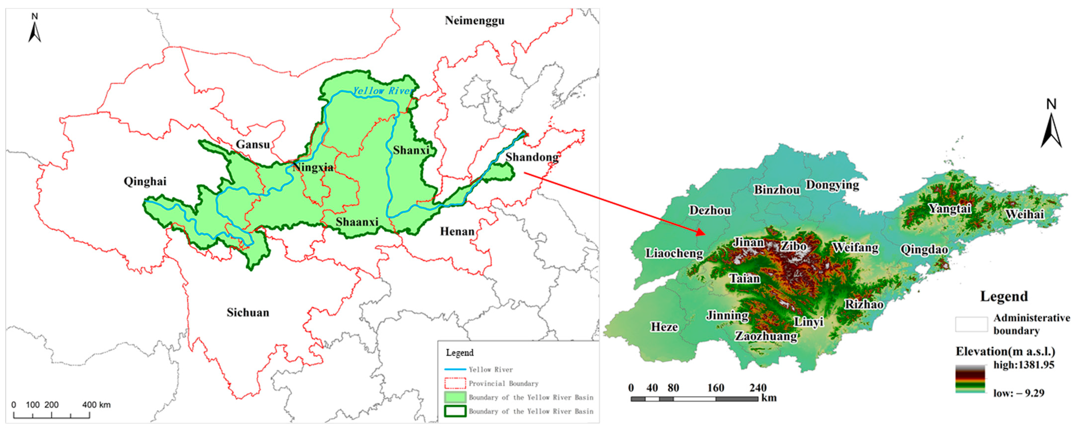
2.1. Study Area and Data

Shandong Province represents the lowest reach of the Yellow River Basin in China, occupies a strategically important position along the eastern coast (Figure 1). Bordered by the Beijing–Tianjin–Hebei region to the north and the Yangtze River Delta to the south, it serves as a western gateway to the Yellow River Basin while facing Japan and South Korea across the sea to the east. As a vital industrial base and strategic pivot for economic development in northern China, Shandong functions as a crucial hub for balanced regional development between north and south, integrated land–sea coordination between east and west, and connectivity between Northeast Asia and the Belt and Road Initiative. The province currently administers 16 prefecture-level regions: Jinan, Qingdao, Zibo, Zaozhuang, Dongying, Yantai, Weifang, Jining, Tai’an, Weihai, Rizhao, Linyi, Dezhou, Liaocheng, Binzhou, and Heze. Characterized by a temperate semi-humid monsoon climate, Shandong experiences four distinct seasons with significant temperature variations. The climate features concurrent heat and rainfall with pronounced seasonal precipitation patterns: cold, dry winters with scant snow; hot summers with concentrated rainfall; and relatively dry spring and autumn seasons. The annual average temperature ranges from 11 to −14 °C, with a multi-year average precipitation of 680.5 mm. Shandong’s river systems belong to three major basins—the Yellow River, Huai River, and Hai River—along with independent peninsula waterways flowing directly to the sea. The Yellow River’s main stream traverses nine regions (Heze, Jining, Tai’an, Liaocheng, Jinan, Dezhou, Binzhou, Zibo, and Dongying) before emptying into the Bohai Sea at Kenli District, Dongying City.
The data used involve water supply volume, water consumption, population, and agricultural indicators, which are primarily sourced from the “Shandong Water Resources Bulletin” and “Shandong Statistical Yearbook”. The “Shandong Water Resources Bulletin” data is officially published by the Shandong Provincial Department of Water Resources, while the “Shandong Statistical Yearbook” is released by the Shandong Provincial Bureau of Statistics. The data series covers the period from 2001 to 2023.

2.2. Methods

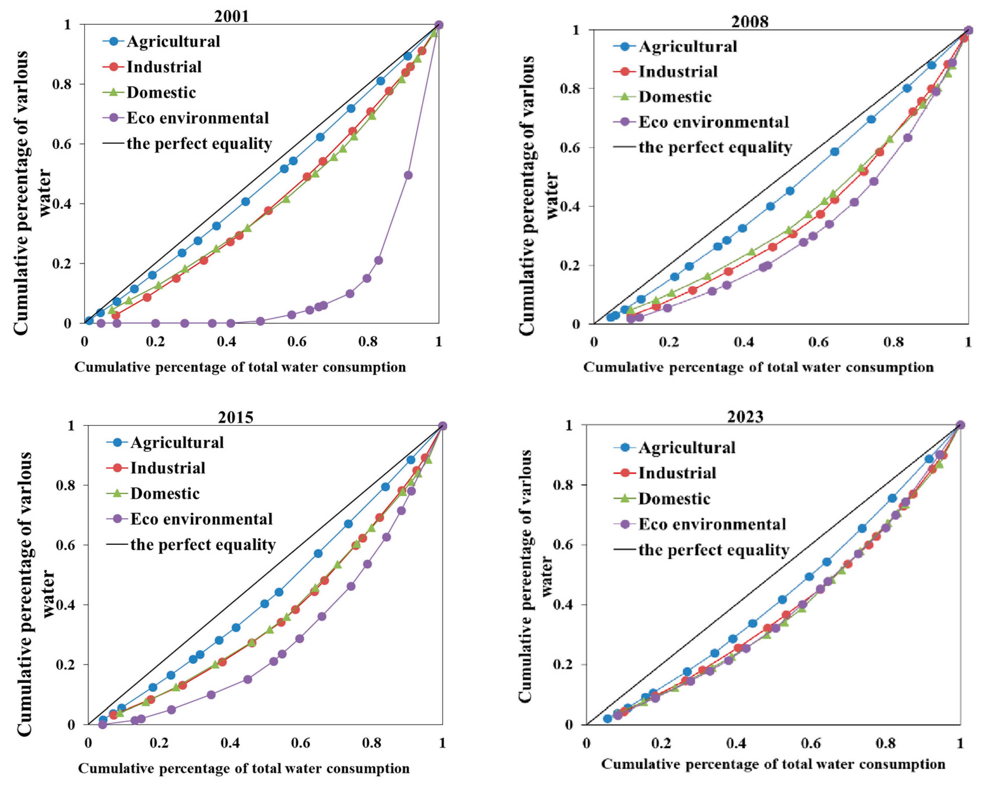
2.2.1. The Lorenz Curve

The Lorenz curve was initially proposed in the early 20th century by Max Otto Lorenz [16] to measure income distribution equality [17]. It is mathematically expressed as
L ( x ) = 1 u 0 x x d F ( x )
where F(x) represents the cumulative distribution function of ordered individuals, while u denotes the mean value.
In the water resources research field, however, the Lorenz curve plots x-axis and y-axis, denoting cumulative percentage of total water use and cumulative percentage of specific water use categories, respectively. As shown in Figure 2, the curve typically exhibits a concave shape. The proximity of a water category’s Lorenz curve to the line of absolute equality (45° line) indicates its spatial distribution uniformity across the study area: if closer to the line, there is a more equitable spatial distribution, and if farther from the line, there is a greater spatial disparity.
When constructing the Lorenz curve, it is necessary to calculate the location quotient (L(Q)) [18]. The location quotient of water consumption is defined as the ratio of the cumulative percentage of a specific water use category in a given region to the cumulative percentage of the region’s total water consumption, which reflects the slope of the Lorenz curve. The formula is expressed as
L(Q) = (Qij/Qj)/(Qi/Q)
where Qij represents the water consumption of category j in region i (m3), Qj denotes the total water consumption of category j (m3), Qi indicates the total water consumption in region i (m3), Q stands for the total water consumption of the study area (m3), L(Q) is the location quotient.

2.2.2. Gini Coefficient

Originally employed to measure income inequality among regional populations, the Gini coefficient has been widely adopted to analyze spatial equilibrium and distribution disparities across different regions. The geometric interpretation of the Gini coefficient represents the ratio between the area enclosed by the line of perfect equality (y = x) and the actual cumulative curve (y = f(x)), as well as the total area under the line of perfect equality (a right-angled triangle). The calculation formula is written as
G = 2 0 1 x f ( x ) d x = 1 2 0 1 f x d x
where G denotes Gini coefficient, f(x) is function of the cumulative distribution curve.
The Gini coefficient typically ranges from 0 to 1, with 0.4 established as the warning threshold. Values ≥0.4 indicate significant or severe inequality in water use distribution. The evaluation criteria for this study follow internationally recognized classification standards [19], as detailed in Table 1.

2.2.3. Mann–Kendall Trend Test

The Mann–Kendall (MK) trend test is one of the most commonly used trend detection methods. Proposed by H.B. Mann and Kendall [17,20], it is a non-parametric statistical method characterized by its computational simplicity and wide applicability, with the capability to eliminate the influence of outliers on trend analysis. For a given time series X = {x1, x2,..., xn}, the non-parametric Mann–Kendall statistic S can be written as
S = i = 1 n 1 j = i + 1 n sgn ( x j x i )
and
sgn ( x j x i ) = + 1 , ( x j x i ) > 0 0 , ( x j x i ) = 0 1 , ( x j x i ) < 0
where sgn(xj − x) is the sign function. The statistic S follows a normal distribution with mean E(S) = 0 and variance Var(S) = n(n − 1)(2n + 5)/18.
The standardized test statistic Z for the normal distribution is given by
Z = S 1 V a r ( S ) , S > 0 0 , S = 0 S + 1 V a r ( S ) , S < 0
In bilateral trend testing, the presence of significant trends in time series data can be determined by examining the confidence interval range of the statistic Z(s). At a given significance level α, if the absolute value of the statistic |Z| exceeds Z(1−α/2), this indicates a statistically significant increasing or decreasing trend in the element’s time series. Conversely, if |Z| is less than Z(1−α/2), the trend in the time series is not statistically significant. Furthermore, the sign of the Z statistic determines the direction of the trend: a positive Z value indicates an increasing trend in the time series, while a negative value signifies a decreasing trend. In this study, we set the confidence level α at 0.05, meaning that when |Z| > 1.64, the result passes the 95% significance test.

2.2.4. Clustering Analysis

Clustering analysis, also known as systematic clustering, is an algorithm that splits or aggregates data according to specific linkage rules and hierarchical structures, ultimately forming a hierarchical sequence of clustering solutions. This method is suitable for classifying small datasets without prior knowledge, and the classification results can be dynamically adjusted based on actual conditions, offering considerable flexibility. In this water-use structure analysis, the data matrix is not excessively large, and the processing time does not need to be extensive. Therefore, hierarchical clustering was selected for this study, with squared Euclidean distance chosen as the distance metric and the Ward’s method (sum of squared deviations) applied as the clustering rule. For a detailed methodology on cluster analysis, please refer to reference [21].

2.2.5. Data Processing

The data processing, Lorenz curve plotting, Gini coefficient calculation, and clustering analysis were performed using Excel 2013, SPSS 17.0, and OriginPro 2021. Mann–Kendall Trend Test is realized through MATLAB 2017a. The spatial distribution characteristics of water use structure were mapped using ArcGIS 10.2 software.

3. Results

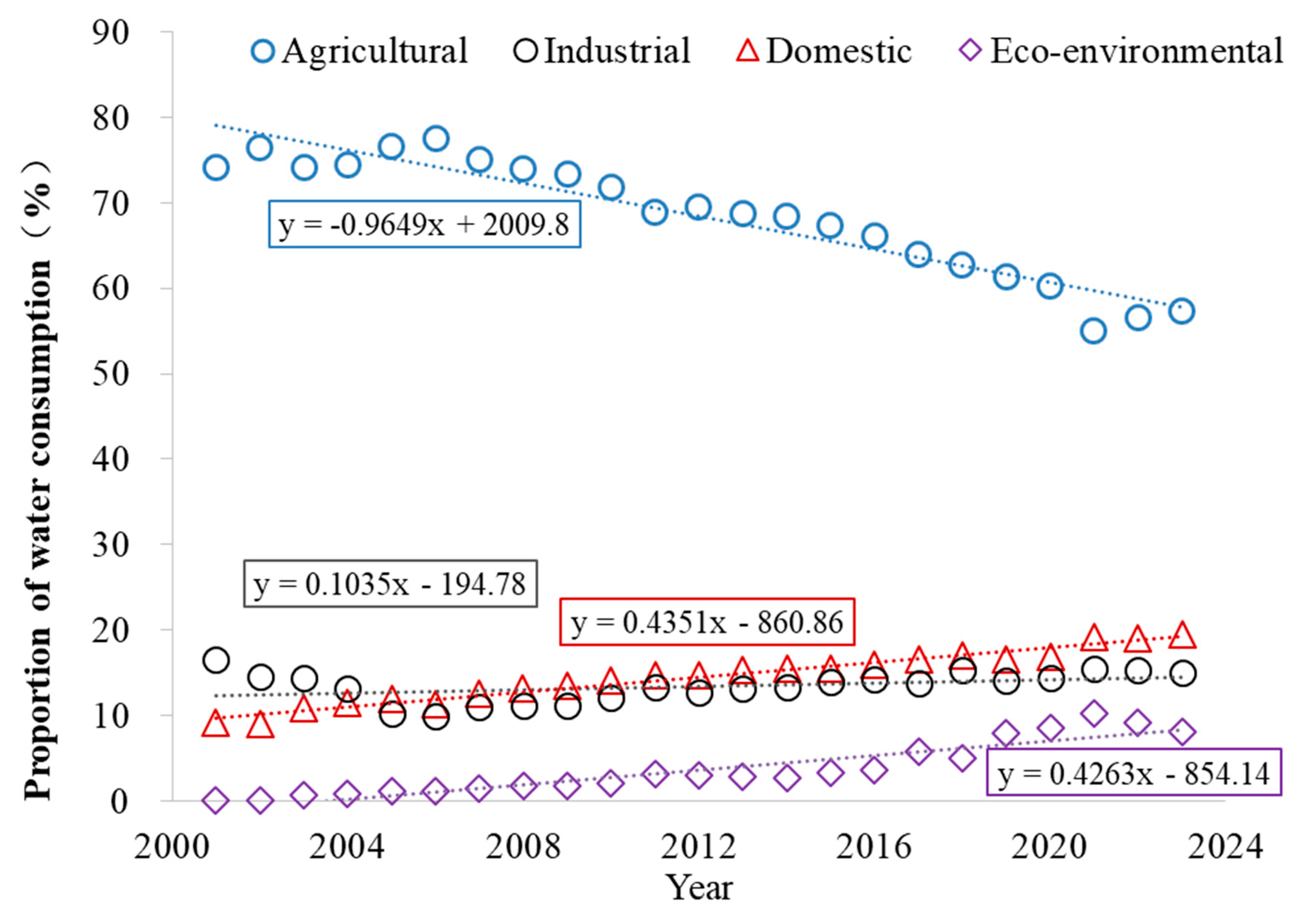
3.1. Statistical Characteristics of Water Use Structure

Water consumption in Shandong is categorized into four types: agricultural, industrial, domestic, and ecological–environmental uses. The temporal variations in water use structure are illustrated in Figure 3. It can be seen that agricultural water use represented the largest proportion, followed by domestic and industrial uses, with ecological–environmental water use being the smallest. From 2001 to 2023, agricultural water accounted for 55.1–77.5% of total use (average: 68.5%), domestic water represented 9.0–19.6% (average: 14.4%), industrial water comprised 10.0–16.6% (average: 14.2%), and ecological–environmental water constituted 0.13–10.2% (average: 3.6%). According to the trend analysis, the proportion of agricultural water use exhibited a yearly decreasing trend from 2001 to 2023, while industrial, domestic, and ecological–environmental water use all showed yearly increasing trends. The Mann–Kendall trend test yielded the following Z-values: agricultural water use −5.65, industrial water use 2.61, domestic water use 6.29, and ecological–environmental water use 5.99. The negative Z-value for agricultural water use indicates a significant decreasing trend, whereas the positive Z-values for industrial, domestic, and ecological–environmental water use all surpassed the significance threshold at α = 0.05. These findings align with the conclusions derived from the linear regression analysis.
Figure 4 illustrates the changing proportions of different water supply sources in Shandong Province. The overall trend shows the following: (1) a consistent annual decrease in groundwater supply proportion; (2) a steady annual increase in unconventional water sources and inter-basin transferred water; (3) fluctuating local surface water supply proportion following a “high-in-wet-years, low-in-dry-years” pattern, influenced by precipitation variability. The inter-basin transferred water primarily consists of Yellow River water and Yangtze River water. In recent years, with the implementation of high-quality development requirements for the Yellow River Basin, Shandong Province has strictly controlled Yellow River water diversion while gradually increasing Yangtze River water utilization. Consequently, the growth in inter-basin transferred water mainly reflects increased Yangtze River water usage. Agricultural irrigation in Shandong predominantly relies on groundwater and Yellow River water. The strict controls on these conventional sources have driven a transition from traditional flood irrigation to water-saving agricultural practices, resulting in a gradual decline in the proportion of agricultural water use. Under strict regulations on conventional water sources, the additional water demands from industrial and ecological sectors have been primarily met by unconventional water sources. This policy orientation has significantly boosted the supply proportion of unconventional water resources.
Statistical analysis was performed on the multi-year average proportions of different water use types relative to total water consumption across 16 regions (Table 2). The results show significant variations in water use composition among different regions. Among all regions, Dezhou had the highest proportion of agricultural water use at 83.64%, while Qingdao had the lowest at 37.87%. The agricultural water use proportion in Dezhou was 2.2 times that of Qingdao. For industrial water use, Zibo showed the highest proportion (25.83%), whereas Heze had the lowest (6.51%), making Zibo’s industrial water use 4.0 times that of Heze. Qingdao recorded the highest proportion of domestic water use (36.28%), while Binzhou had the smallest proportion (7.01%). The domestic water use in Qingdao was 5.2 times that of Binzhou. In terms of ecological water use, Jinan had the highest proportion (6.65%), and Yantai had the lowest (1.06%), with Jinan’s ecological water use being 6.3 times that of Yantai. Among all water use sectors, ecological water use showed the most significant regional differences, while agricultural water use displayed the smallest variation. According to the coefficient of variation analysis, agricultural water use had a variation coefficient of 19.84%, belonging to low variability, while industrial, domestic and ecological water use showed moderate variability with coefficients ranging between 37.65% and 45.51%.
Cluster analysis was also conducted on the water use structures across 16 regions, with the results shown in Figure 5. These regions can be divided into 4 distinct categories based on their water use patterns. The first category consists solely of Qingdao, characterized by predominant domestic and industrial water use. In Qingdao, domestic and industrial water consumption accounts for 56.6% of total usage, while agricultural water use represents only 37.9%. The second category includes Rizhao, Zibo, Weifang, Zaozhuang, Jinan, and Dongying. These regions demonstrate balanced water use structures, with agricultural water consumption ranging between 52.3% and 56.4%, and combined domestic/industrial water use accounting for 36.9% to 44.8%. The third category is represented exclusively by Yantai, Weihai, Tai’an, and Linyi, where agricultural water use constitutes between 6.37% and 67.1%. The fourth category comprises Jining, Liaocheng, Binzhou, Dezhou, and Heze. These regions are dominated by agricultural water use, with proportions ranging from 77.9% to 83.6%, while other water use types account for relatively small shares, indicating a distinctly agriculture-oriented water consumption pattern.

3.2. Spatial Distribution Characteristics of Water Use Structure

Spatial distribution characteristics of water use structure across regions in Shandong Province are illustrated in Figure 6. Overall, the visualization reveals distinct spatial patterns.
For agricultural water use, the province exhibits a clear west-to-east decreasing gradient. In 2001, western and central regions including Dezhou, Binzhou, Heze and Weifang demonstrated agricultural water use proportions exceeding 80%, while eastern Weihai recorded the lowest proportion below 60%, with other regions ranging between 60 and 80%. By 2023, this spatial pattern became more pronounced with overall reduced proportions—western regions like Dezhou, Heze, and Liaocheng maintained over 70%, whereas Qingdao in the east dropped below 30%, and central/southern regions, including Weifang, Jinan, Zibo, Zaozhuang, and Rizhao, ranged between 30 and 50%.
Industrial water use displays a central-high, eastern-medium, western-low distribution. In 2001, central regions (Dongying, Zibo, Tai’an, Zaozhuang) and eastern coastal regions (Qingdao, Weihai) showed 20–30% industrial use, contrasting with a mere 5% in Heze in the west. This pattern persisted in 2023 with central regions (Zibo, Dongying, Binzhou, Zaozhuang) and eastern coastal regions (Rizhao, Weihai) ranging 20–32%, while western regions (Heze, Dezhou, Liaocheng) remained below 10%. Domestic water use demonstrates an inverse west-to-east increasing pattern. In 2001, eastern coastal regions (Weihai, Qingdao, Yantai, Rizhao) and central regions (Zibo, Zaozhuang, Jinan) ranged 10–20%, with others below 10%. By 2023, proportions increased significantly—Qingdao reached 46%, other coastal/central regions 23–28%, while western Liaocheng remained below 10%. Ecological–environmental water use shows dramatic temporal changes. In 2001, all regions reported minimal usage (<1%). By 2023, significant increases emerged with central/eastern regions (Jinan, Zaozhuang, Qingdao, Rizhao) exceeding 12%, western regions (Dezhou, Heze, Jining) below 5%, and others between 5 and 10%. The spatial distribution evolved into a distinct central/eastern-high, western-low pattern.

3.3. Variation Characteristics of Water Use Structure

Over the period from 2001 to 2023, significant changes occurred in the water use structures of all regions (Figure 7). Notably, the proportion of agricultural water use showed a declining trend across all regions, while domestic and ecological–environmental water use generally increased. Industrial water use exhibited mixed trends, with some regions showing increases and others showing decreases. The reduction in agricultural water use varied considerably among regions. The proportion of agricultural water use decreased by over 30% in Qingdao, Rizhao and Weifang, with the most significant reductions occurring in Qingdao and Rizhao (39% decrease). Zibo, Jinan, Binzhou, and Zaozhuang saw reductions exceeding 20% in agricultural water use proportions. Regions including Linyi, Weihai, Heze, and Yantai experienced decreases of more than 10%. The changes were relatively smaller (less than 10% reduction) in five regions: Liaocheng, Tai’an, Dongying, Jining, and Dezhou.
The changes in industrial water use proportions across Shandong show significant regional variations. Tai’an recorded the most substantial decrease of over 10%. Ten regions, including Dongying, Jinan, Yantai, Jining, Qingdao, Zaozhuang, Linyi, Weihai, Dezhou, and Liaocheng, saw reductions ranging from 3.8% to 5.9%. Conversely, three regions—Heze, Weifang, and Binzhou—experienced increases between 1.8% and 8.1%, while Zibo and Rizhao showed particularly notable growth, with both exceeding a 10% increase.
All regions showed increases in domestic water use proportions, though with notable variations. Qingdao experienced the most significant rise, increasing by 29%. Six regions—Weifang, Jinan, Rizhao, Linyi, Zaozhuang, and Yantai—saw their domestic water use proportions grow between 10.8% and 18.1%. The remaining regions all registered increases below 10%. Substantial changes occurred in ecological water use proportions. In 2001, all regions in the province maintained ecological–environmental water use below 1%, but by 2023, every city demonstrated significant growth exceeding 3%. Particularly noteworthy were Qingdao, Jinan, Zaozhuang, and Rizhao, where ecological water use proportions surged beyond 12.4%. The other twelve regions showed increases ranging from 3% to 9.3%. These developments clearly demonstrate how implementing the national strategy for ecological protection and high-quality development in the Yellow River Basin has significantly improved regional ecological–environmental water usage.

3.4. Evolution Characteristics of Water Use Structure

Figure 8 presents the Lorenz curves for different water use types in Shandong Province during selected representative years (2001, 2008, 2015, and 2023). The results show that from 2001 to 2023, the spatial distribution of agricultural water use became slightly less equitable, though the degree of change was minimal. Notably, the Lorenz curve for agricultural water consistently remained closest to the line of absolute equality, indicating that the spatial distribution of agricultural water across the province has maintained remarkable uniformity over the years. This reflects the establishment of a long-term, stable agricultural water allocation scheme with relatively small disparities in utilization among regions.
For industrial and domestic water use, the equity of spatial distribution showed no significant changes. Their Lorenz curves remained farther from the line of absolute equality compared to agricultural water, with the domestic water curve exhibiting a slight downward trend, suggesting persistent disparities in spatial distribution among regions. The most substantial changes occurred in ecological–environmental water use. In 2001, its Lorenz curve was the farthest from absolute equality, but it gradually approached the equality line in 2008 and 2015. By 2023, it even overlapped with the curves for industrial and domestic water use. This demonstrates a clear improvement in the equity of ecological water distribution over time, reflecting how regions have increasingly prioritized ecological protection during these 23 years. The growing ecological water usage and converging patterns among regions indicate successful efforts to balance environmental water needs across the province.
In order to better evaluate the spatial distribution equilibrium and multi-year variations in different water use types, the Gini coefficients and their assessment results from 2001 to 2023 were calculated (Table 3). The Gini coefficient for agricultural water use generally exhibited an increasing trend year by year, though the later changes were not particularly pronounced. It rose from 0.06 in 2011 to 0.15 in 2023. This pattern reflects Shandong’s status as a major agricultural province and key grain production area, where agricultural water dominates usage across all regions, resulting in relatively minor spatial disparities. However, with ongoing industrial restructuring, functional zoning in territorial spatial planning, and water-saving agricultural practices, some regions have gradually reduced their agricultural water use proportions while others maintain higher levels, leading to an overall increase in the Gini coefficient. Nevertheless, the spatial equilibrium of agricultural water use consistently remained in the “absolute equality” range, indicating minimal differences among regions.
The Gini coefficient for industrial water use remained largely stable, fluctuating between 0.19 and 0.31 from 2021 to 2023, consistently falling within the “relative equality” range. This stability reflects steady industrial development across all regions with no significant disparities in industrial water use proportions. Similarly, the Gini coefficient for domestic water use showed minimal variation, ranging from 0.19 to 0.28 during the study period, maintaining a “relative equality” status. The spatial distribution patterns of domestic water use aligned closely with industrial water use, showing no substantial proportional differences among regions.
The Gini coefficient for ecological–environmental water use exhibited significant fluctuations over time. In 2001 and 2002, the coefficients reached 0.76 and 0.77, respectively, indicating a state of extreme disparity. After 2003, the Gini coefficient dropped below 0.5. From 2003 to 2021, it fluctuated between 0.34 and 0.48, meaning the ecological water use distribution alternated between relative rationality and substantial disparity. By 2022 and 2023, the coefficient further decreased below 0.3, reaching a relatively balanced state. This improvement in the equity of ecological water distribution resulted from enhanced emphasis on ecological water security across regions, driven by initiatives such as high-quality development in the Yellow River Basin, ecological flow guarantees, and the Mother River Revitalization Action, which collectively promoted more balanced allocation of ecological water resources.
In summary, the spatial distribution of agricultural, industrial, and domestic water use all maintained Gini coefficients below the 0.4 warning threshold, while ecological water use showed progressively reduced disparities. However, further coordinated planning and rational allocation remain necessary for optimizing spatial water distribution patterns.

4. Discussion

The implementation of a mandatory water quota management system in the Yellow River Basin reflects China’s commitment to addressing water scarcity through stringent regulatory measures. As a downstream province, Shandong faces acute water supply–demand imbalances exacerbated by climate change, upstream water withdrawals, and rapid urbanization [22]. The principle of “water determining urban development, land use, population size, and industrial output” aligns with the concept of “water planetary boundaries,” which emphasizes that sustainable development must operate within ecological limits [23]. Shandong’s approach mirrors global best practices, such as Australia’s Murray–Darling Basin Plan, where water quotas were enforced to restore ecological balance [24]. However, the success of such systems depends on robust enforcement, adaptive management, and stakeholder participation [25]. Aligned with Shandong’s territorial spatial planning, water resource carrying capacity should guide zoning regulations to optimize water use structures according to functional area requirements. Major agricultural production zones—including the plains of Dezhou, Heze, Binzhou, Liaocheng, and Jining—are crucial for food security and agricultural supply; these regions should comprehensively advance water-efficient agriculture and improve irrigation efficiency. Urbanized development zones, concentrated in the Jinan and Qingdao metropolitan areas, as well as core urban regions like Yantai–Weihai, Linyi, Jining–Zaozhuang, and Heze, along key transport corridors (e.g., Jiaozhou–Jinan and Beijing–Shanghai routes), serve as hubs for population and industrial agglomeration. These areas must strictly control population growth and water-intensive industries in overburdened regions, implement industrial water conservation and pollution reduction, and promote urban water loss reduction to establish urban layouts and modern industrial systems compatible with water resource capacities. Key ecological functional zones—primarily in Dongying, Tai’an, Linyi, Jining, and Yantai—are vital for maintaining ecosystem services and ecological product supply; these areas should enhance ecological water allocation guarantees. Consequently, Shandong’s water management framework provides a blueprint for balancing development and sustainability in water-stressed regions. By integrating technological innovation, strict regulation, and cross-sectoral coordination, the province can mitigate water risks while supporting the Yellow River Basin’s ecological goals. Wang et al. [26] employed a modified entropy method to analyze the evolutionary characteristics of water use system structure in Shandong Province from 2004 to 2019. Their results demonstrated that through agricultural technological advancements, Shandong Province has been progressively improving the previously dominant single-pattern agricultural water use, leading to increasingly coordinated water use proportions and a more rational water system structure across the province. The findings of the present study are fundamentally consistent with those of Wang et al.
The limitations of this study mainly lie in two aspects: First, the study area is not too broad. This research focuses on Shandong Province, located at the lowest reach of the Yellow River Basin. The Yellow River flows through nine provinces in China, with a total basin area of 795,800 km2. The drainage area within Shandong Province is 18,300 km2, accounting for only 2.3% of the entire Yellow River Basin. Future studies should aim to conduct a more comprehensive analysis of water use structure changes across the entire Yellow River Basin. Second, the limitation of driving factors. Changes in water use structure are not only influenced by water supply structure but may also be affected by factors such as population shifts, economic development, and cropping pattern adjustments. This study primarily analyzed the historical variation in water supply sources. In future research, it would be ideal to conduct an in-depth exploration of the driving factors behind water use structure changes from multiple perspectives, including water supply structure variations and socioeconomic development.

5. Conclusions

This study examined Shandong Province—a representative area of water resource conflicts in the lower Yellow River Basin—using Lorenz curves, Gini coefficients, cluster analysis, and geostatistical methods to analyze spatiotemporal evolution characteristics of water use structure. Key findings include the following:
(1)
From 2001 to 2023, Shandong’s water use structure progressively improved, demonstrating more rational and comprehensive water resource utilization. As a major agricultural province, Shandong maintained the highest proportion of agricultural water use, followed by industrial and domestic water, with ecological–environmental water being the smallest. With advancing economic and technological development, all water use categories showed positive changes, particularly in agricultural and ecological water proportions, while industrial and domestic water use exhibited smaller but consistent increases.
(2)
Agricultural water use maintained absolute spatial equality (Gini coefficient < 0.2), showing minimal regional disparities. Industrial and domestic water use exhibited fluctuating but stable Gini coefficients (0.2–0.3), indicating relative spatial equality. Ecological water use demonstrated significant improvement, transitioning from “significant disparity” (Gini > 0.4) to “reasonable distribution,” though further optimization remains possible.
(3)
Clear regional variations existed among Shandong: the western regions (e.g., Dezhou, Heze) showed high agricultural water use but low industrial/domestic proportions; central areas (e.g., Zibo) had the highest industrial water use; and the eastern zones (e.g., Qingdao, Yantai) exhibited lower agricultural but higher industrial/domestic water shares. All regions increased ecological water use to varying degrees, with the overall spatial equilibrium remaining stable across the province.
(4)
With the advancement of the national strategy for ecological protection and high-quality development in the Yellow River Basin, ensuring ecological–environmental water supply will become a key priority for optimizing the water use structure in Shandong Province in the coming period. These findings underscore the need for differentiated water management policies aligned with regional characteristics to support sustainable development in the Yellow River Basin.

Author Contributions

Conceptualization and methodology, C.L.; validation and investigation, C.L. and K.W.; resources and data curation, H.L.; writing—original draft preparation, C.L.; writing—review and editing, Y.Y.; supervision and project administration, M.F.; funding acquisition, C.L. and M.F. All authors have read and agreed to the published version of the manuscript.

Funding

This research was funded by the Shandong Provincial Natural Science Foundation (NO. ZR2021QD043), the Key R&D Program Project of Shandong Province (Major Science and Technology Innovation Project) (NO. 2023CXGC010905), and the Postdoctoral Innovation Project of Shandong Province (SDCX-ZG-202400185).

Data Availability Statement

The data used in this paper are accessible through “Water Resources Bulletin of Shandong Province” (http://wr.shandong.gov.cn/zwgk_319/fdzdgknr/tjsj/szygb/) (accessed on 10 April 2025).

Acknowledgments

The authors are highly thankful to the Key R&D Program Project of Shandong Province and the Shandong Provincial Natural Science Foundation Project. We also would like to express our gratitude to our colleagues at the Water Resources Research Institute of Shandong Province for their assistance in data analysis and map modification. Finally, the authors appreciate the constructive suggestions provided by the anonymous reviewers, which have significantly improved the quality of this paper.

Conflicts of Interest

The authors declare no conflicts of interest.

References

  1. Wu, H.; Wang, X.; Shahid, S.; Ye, M. Changing Characteristics of the Water Consumption Structure in Nanjing City, Southern China. Water 2016, 8, 314. [Google Scholar] [CrossRef]
  2. Yue, C.; Nan, T.; Qian, Y.; Liu, F.; Guo, C.Y.; Zhen, S.J. Using Niche Model to Analyze Water Consumption Structure in Jinan City, Shandong. Water 2024, 16, 549. [Google Scholar] [CrossRef]
  3. Bai, P.; Liu, C.M. Evolution law and attribution analysis of water utilization structure in Beijing. South North Water Transf. Water Sci. Technol. 2018, 16, 1–9. [Google Scholar]
  4. Yi, J.J.; Chen, Z.C.; Yang, C.P.; Li, Y.Q. Analysis of Spatiotemporal Characteristics of Regional Water Utilization Structure Based on Information Entropy. J. China Hydrol. 2019, 39, 2–17. [Google Scholar]
  5. Jiao, S.X.; Li, Q.Y.; Wang, A.Z.; Liu, Y.Q.; Yin, Y.X.; Zhao, R.Q.; Zhang, J.W. Dynamic evolution analysis of water consumption structure and industrial structure based on niche in Anyang City. Water Resour. Prot. 2021, 37, 79–85. [Google Scholar]
  6. Hou, L.X.; Wen, L.; Zhang, X.F.; Wang, L.X.; Zhao, J.; Du, F.L. Quantification of water footprint and analysis of water resources evaluation in Inner Mongolia. J. China Agric. Univ. 2021, 8, 182–195. [Google Scholar]
  7. Xu, W.L.; Zhou, W.H.; Zhang, J.; Zheng, X.J.; Jin, H. Analysis on Temporal Inhomogenenity of Runoff in Tumen River Mainstream Based on Lorenz Curve. Bull. Soil Water Conserv. 2015, 35, 128–132. [Google Scholar]
  8. Sueyoshi, T.; Qu, J.J.; Li, A.J.; Liu, X.H. A new approach for evaluating technology inequality and diffusion barriers: The concept of efficiency Gini coefficient and its application in Chinese provinces. Energy 2021, 235, 121256. [Google Scholar] [CrossRef]
  9. Hu, Z.N.; Chen, Y.Z.; Yao, L.M.; Wei, C.T.; Li, C.Z. Optimal allocation of regional water resources: From a perspective of equity-efficiency trade off. Resour. Conserv. Recycl. 2016, 109, 102–113. [Google Scholar] [CrossRef]
  10. Zhou, Y.Y.; Zhou, G.F.; Huang, Q.F.; Yue, L. A Study on Distribution of Production, Living and Ecological Space in Karst Areas Based on Lorenz Curves and Land Use Transitions. Bull. Soil Water Conserv. 2020, 40, 297–304. [Google Scholar]
  11. Wu, X.; Tao, T.; Wu, R.Z.; Wang, X.L. Analysis on the Characteristics of Temporal and Spatial Dynamic Evolution of Water Use Structure in Area of Northern China. Sci. Technol. Eng. 2021, 21, 11768–11775. [Google Scholar]
  12. Chen, L.; Yang, Y.K.; Liu, Y.; Wang, T.Y.; Jiao, Y.W. Analysis of Water Consumption Structure in Gansu Province Based on Lorentz Curve. J. Chang. River Sci. Res. Inst. 2021, 38, 25–33. [Google Scholar]
  13. Dong, Z.F.; Qu, A.Y.; Ji, Y.Q. On ecological environment protection of lower reaches of Yellow River with high-quality development strategy. Sci. Technol. Rev. 2020, 38, 109–115. [Google Scholar]
  14. Zhao, Q.; Liu, X.M.; Gao, Q.; Xiong, D.; Zou, C.H. Evaluation of water resources carrying capacity in Shandong province based on fuzzy comprehensive evaluation. Ecol. Sci. 2018, 4, 188–194. [Google Scholar] [CrossRef]
  15. Jiang, D.J.; Li, L.J. Analysis of water use efficiency and its dynamics in Shandong Province during 2011–2020. J. Water Resour. Water Eng. 2023, 34, 10–18. [Google Scholar]
  16. Lorenz, M.O. Methods of Measuring the Concentration of Wealth. Publ. Am. Stat. Assoc. 1905, 9, 209–219. [Google Scholar] [CrossRef]
  17. Kendall, M.G. Rank Correlation Methods; Charles Griffin: London, UK, 1975. [Google Scholar]
  18. Chorley, R.J.; Haggett, P. Trend-Surface Mapping in Geographical Research. Trans. Inst. Br. Geogr. 1965, 37, 47–67. [Google Scholar] [CrossRef]
  19. Barrett, C.R.; Salles, M. On a Generalisation of the Gini Coefficient. Math. Soc. Sci. 1995, 30, 235–244. [Google Scholar] [CrossRef]
  20. Mann, H.B. Non parametric tests against trend. Econometrica 1945, 13, 245–259. [Google Scholar] [CrossRef]
  21. Zhao, Y.X.; Li, Y.B.; Zhang, H.T.; Wang, S.X. Study on Zoning for Water Resources Development and Utilization Based on Cluster Analysis. Water Resour. Power 2022, 11, 40–44. [Google Scholar]
  22. Ba, W.X.; Wang, D.J.; Gong, B.H.; Dai, Y.H.; Yang, Z.P.; Liu, Z.F. Urban water scarcity in China: A systematic review of research advances and future directions. Appl. Geogr. 2023, 159, 103069. [Google Scholar] [CrossRef]
  23. Rockström, J.; Steffen, W.; Noone, K.; Persson, Å.; Chapin, F.S.; Lambin, E.F.; Lenton, T.M.; Scheffer, M.; Folke, C.; Schellnhuber, H.J.; et al. A safe operating space for humanity. Nature 2009, 461, 472–475. [Google Scholar] [CrossRef] [PubMed]
  24. Grafton, R.Q.; Pittock, J.; Davis, R.; Williams, J.; Fu, G.; Warburton, M.; Udall, B.; McKenzie, R.; Yu, X.; Che, N.; et al. Global insights into water resources, climate change and governance. Nat. Clim. Chang. 2013, 3, 315–321. [Google Scholar] [CrossRef]
  25. Annisa, C.N.; Purwanti, E.; Sardjono, M.A. Water sustainability in the Anthropocene: Challenges and solutions for a changing world. IOP Conf. Ser. Earth Environ. Sci. 2023, 1282, 012013. [Google Scholar] [CrossRef]
  26. Wang, Y.Q.; Li, S.; Kong, K.; Xu, J. Evolution Characteristics and Influencing Factors of Water Use System Structure in Shandong Province Analyzed on the Basis of Improved Entropy. J. Univ. Jinan (Sci. Technol.) 2023, 37, 401–407+420. [Google Scholar]
Figure 1. Geographic location map of Yellow River Basin and Shandong Province.
Water 17 02315 g001
Figure 2. Schematic diagram of the Lorenz curve.
Water 17 02315 g002
Figure 3. Variation curves of water use proportions in Shandong Province.
Water 17 02315 g003
Figure 4. Variation in proportions of different water supply sources in Shandong Province.
Water 17 02315 g004
Figure 5. Cluster analysis results of water consumption structure types.
Water 17 02315 g005
Figure 6. Spatial distribution of water use structure in 2001 and 2023.
Water 17 02315 g006
Figure 7. Variation trends of different water use types between 2001 and 2023.
Water 17 02315 g007
Figure 8. Lorenz curves of different water use types in Shandong Province.
Water 17 02315 g008
Table 1. Gini coefficient evaluation criteria.
Gini Coefficient0 < G < 0.20.2 ≤ G < 0.30.3 ≤ G < 0.40.4 ≤ G < 0.5≥0.5
Evaluation resultAbsolute equalityRelative equalityRelatively reasonableSignificant disparityExtreme disparity
Table 2. Statistics of water consumption proportion in Shandong province.
Proportion of Water ConsumptionMinimum (%)Maximum (%)Average (%)CV (%)SkewnessKurtosis
Agricultural37.8783.6464.5119.84−0.17−0.43
Industrial6.5125.8315.4937.650.16−1.04
Domestic7.0136.2816.4545.401.112.14
Ecological1.066.653.5745.510.02−0.80
Table 3. Evaluation results of Gini coefficients for different types of water use in Shandong Province (2001–2023).
Year AgriculturalResultIndustrialResultDomesticResultEcologicalResult
20010.06 absolute equality0.20 relative equality0.20 absolute equality0.76 significant disparity
20020.06 absolute equality0.19 relative equality0.25 relative equality0.77 significant disparity
20030.07 absolute equality0.23 relative equality0.23 relative equality0.39 relatively reasonable
20040.07 absolute equality0.22 relative equality0.19 absolute equality0.40 relatively reasonable
20050.08 absolute equality0.29 relative equality0.23 relative equality0.48 significant disparity
20060.08 absolute equality0.31 relatively reasonable0.24 relative equality0.41 significant disparity
20070.08 absolute equality0.30 relative equality0.25 relative equality0.39 relatively reasonable
20080.09 absolute equality0.29 relative equality0.27 relative equality0.37 relatively reasonable
20090.09 absolute equality0.28 relative equality0.26 relative equality0.37 relatively reasonable
20100.09 absolute equality0.24 relative equality0.26 relative equality0.35 relatively reasonable
20110.10 absolute equality0.23 relative equality0.24 relative equality0.45 significant disparity
20120.10 absolute equality0.22 relative equality0.26 relative equality0.39 relatively reasonable
20130.10 absolute equality0.23 relative equality0.25 relative equality0.35 relatively reasonable
20140.10 absolute equality0.23 relative equality0.25 relative equality0.37 relatively reasonable
20150.12 absolute equality0.26 relative equality0.26 relative equality0.41 significant disparity
20160.13 absolute equality0.26 relative equality0.26 relative equality0.44 significant disparity
20170.13 absolute equality0.26 relative equality0.26 relative equality0.41 significant disparity
20180.14 absolute equality0.23 relative equality0.27 relative equality0.41 significant disparity
20190.14 absolute equality0.22 relative equality0.28 relative equality0.48 significant disparity
20200.15 absolute equality0.24 relative equality0.27 relative equality0.41 significant disparity
20210.15 absolute equality0.21 relative equality0.24 relative equality0.34 relatively reasonable
20220.14 absolute equality0.22 relative equality0.25 relative equality0.23 relative equality
20230.15 absolute equality0.23 relative equality0.25 relative equality0.24 relative equality
Disclaimer/Publisher’s Note: The statements, opinions and data contained in all publications are solely those of the individual author(s) and contributor(s) and not of MDPI and/or the editor(s). MDPI and/or the editor(s) disclaim responsibility for any injury to people or property resulting from any ideas, methods, instructions or products referred to in the content.

