Article

Study on the Hydrogeological Characteristics of Roof Limestone Aquifers After Mining Damage in Karst Mining Areas

1
School of Resources and Earth Science, China University of Mining and Technology, Xuzhou 221116, China
2
Guizhou Yuxiang Mining Group Investment Co., Ltd., Bijie 551800, China
3
College of Mining Engineering, Guizhou University of Engineering Science, Bijie 551700, China
*
Author to whom correspondence should be addressed.
Water 2025, 17(15), 2264; https://doi.org/10.3390/w17152264
Submission received: 4 June 2025 / Revised: 7 July 2025 / Accepted: 13 July 2025 / Published: 30 July 2025
(This article belongs to the Section Hydrogeology)

Abstract

To study hydrogeological characteristics after the occurrence of abnormal water bursts from the weak water-rich (permeable) aquifer of the Changxing Formation limestone overlying deep working faces during production in Guizhou karst landform mining areas, hydrogeological data covering the exploration and production periods of the Xinhua mining region in Jinsha County, Guizhou Province, were collected. On the basis of surface and underground drilling, geophysical exploration techniques, empirical equations, and indoor material simulation methods, the hydrogeological evolution characteristics of the Changxing Formation limestone in the mining region after mining damage to coalbed 9 were studied. The research results indicated that the ratio of the height of the roof failure fracture zone (as obtained via numerical simulation and ground borehole detection) to the mining height exceeded 25.78, which is far greater than the empirical model calculation values (from 13.0 to 15.8). After mining the underlying coalbed 9, an abnormal water-rich area developed in the Changxing Formation limestone, and mining damage fractures led to the connection of the original dissolution fissures and karst caves within the limestone, resulting in the weak water-rich (permeable) aquifer of the Changxing Formation limestone becoming a strong water-rich (permeable) aquifer, which served as the water source for mine water bursts. Over time, after mining damage occurrence, the voids in the Changxing Formation limestone were gradually filled with various substances, yielding water storage space and connectivity decreases. The specific yield decreased with an increasing water burst time and interval after the cessation of mining in the supply area, and the correlation coefficient R was 0.964, indicating a high degree of correlation between the two parameters.

1. Introduction

Guizhou Province is the main coal mining area in the karst region of southwestern China, and Jinsha County is one of the important coal mining areas in this province. In the early stages of mining in karst mining areas in Guizhou Province, atmospheric precipitation serves as the primary water recharge source during mine operations [1,2,3,4,5,6,7]. In the Xinhua mining region, the Changxing Formation limestone exhibits extensive surface outcropping, and the limestone can directly receive atmospheric precipitation and indirectly fill stopes with water. A clear correlation exists between mine water inflow and atmospheric precipitation [5,8]. In the mining area, the Changxing Formation limestone is a weak water-rich (permeable) aquifer with favorable water-rich properties in terms of local structure, dissolution fissures, and karst caves. The formation can serve as a channel for rainfall to supply water to deep mining stopes. Although there is a significant difference in the inflow of underground water between the rainy and dry seasons in mines near coalbed outcrops within the mining area, bursts do not occur at the early stages of mining [2,4]. Because of the expansion of goaf areas and the increasing mining intensity in multiple coal mines within the mining region, frequent roof water bursts have occurred in mines where deep coalbeds are mined, causing the working face to flood and resulting in accidents and casualties [9,10,11].
To study the mechanism underlying water bursts, various scholars from research institutions, colleges, and universities have focused mainly on the Permian and Jurassic sandstone aquifers in the northern part of the region. Researchers have studied the mechanism driving roof water bursts [12,13,14,15] and investigated the mechanism or treatment of water bursts from the bottom limestone aquifer [16,17,18]; however, no researchers have investigated the mechanism underlying roof water bursts from limestone. The water storage characteristics of limestone aquifers depend mainly on dissolution fissures and karst caves, which differ significantly from those of sandstone aquifers that depend mainly on fractures. Therefore, the above research results cannot reveal the failure characteristics or the water burst mechanism of the Changxing Formation limestone. Scholars and engineering technicians have employed drilling methods [19] to study the recharge characteristics of the water source and aquifer in the top plate of the stope, and they have determined the characteristics of the water source for water bursts and the aquifer in the top plate, thereby providing a foundation for preventing and mitigating water hazards and implementing relevant control measures in mines. However, since these studies were conducted under the condition that the top plate remained unaffected by mining, they could not reveal the water-filling characteristics of the aquifer after the occurrence of damage of the known aquifer in the coalbed roof during mining [1,4,9,10]. However, few scholars or engineering technicians have investigated the phenomenon of water bursts from the Changxing Formation limestone in the roof within the Xinhua mining region in northern Guizhou, China, where the water content is low and no water bursts occur at the early stage of mining. Many scholars, such as Jinjun Li et al. [20] and Jiabo Xu et al. [21], have investigated fracture zones that conduct roof water. Because the simulated coalbed roofs mainly comprise sandstone, sandy mudstone, and other rock types, with no developed limestone strata and few coalbeds, this approach cannot be used to accurately predict the heights of the water-conducting fracture zone in the coalbed roof and coalbeds in the Xinhua region. However, in previous research on water hazards caused by the Changxing Formation limestone in the roof, the main focus has been on water during bed separation [1,3,22,23]. Research on the changes in the hydrogeological conditions of the Changxing Formation limestone after coal mining and damage is lacking, as is research on water channels. Thus, previous studies have not reasonably clarified the mechanism of water bursts from limestone in the Changxing Formation. Since existing research results for roof water hazards pertain to aquifers with moderate to high water abundance levels before the occurrence of mining influences [20,21,24,25] and since it is difficult to identify cases of water bursts from weak water-rich aquifers in the roof after mining damage and to obtain hydrogeological condition-related research results for weak water-rich aquifers in the roof after water bursts, it is particularly important to study the hydrogeological conditions of weak water-rich (permeable) aquifers in the roof after mining damage.
In this study, large amounts of geological and hydrogeological data from the Xinhua mining region were collected and analyzed. Empirical equations, material simulation methods, and ground borehole detection techniques were employed to investigate the damage mechanism and height of the roof after coalbed mining below the Changxing Formation in the Xinhua karst mining region. Additionally, the hydrogeological conditions of the Changxing Formation limestone before and after mining-induced damage were investigated, and the specific yield of Changxing Formation limestone after the occurrence of mining damage was calculated on the basis of onsite measurement data. The research results have broken through the precedent of weakly water-bearing (permeable) layers without water burst, providing a theoretical basis and practical reference data for the treatment of roof water burst hazards in mines with similar hydrogeological conditions.

2. Materials and Methods

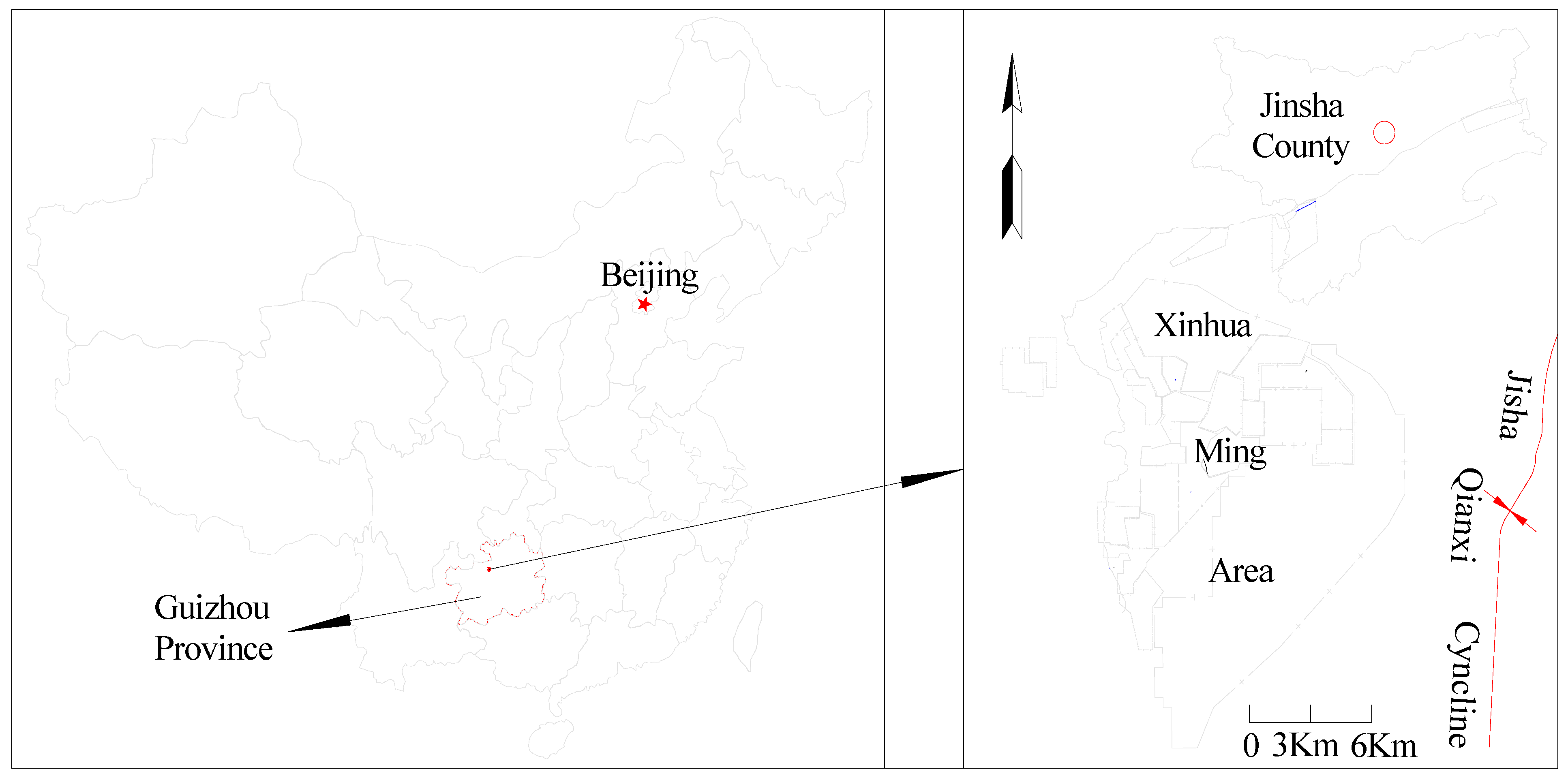
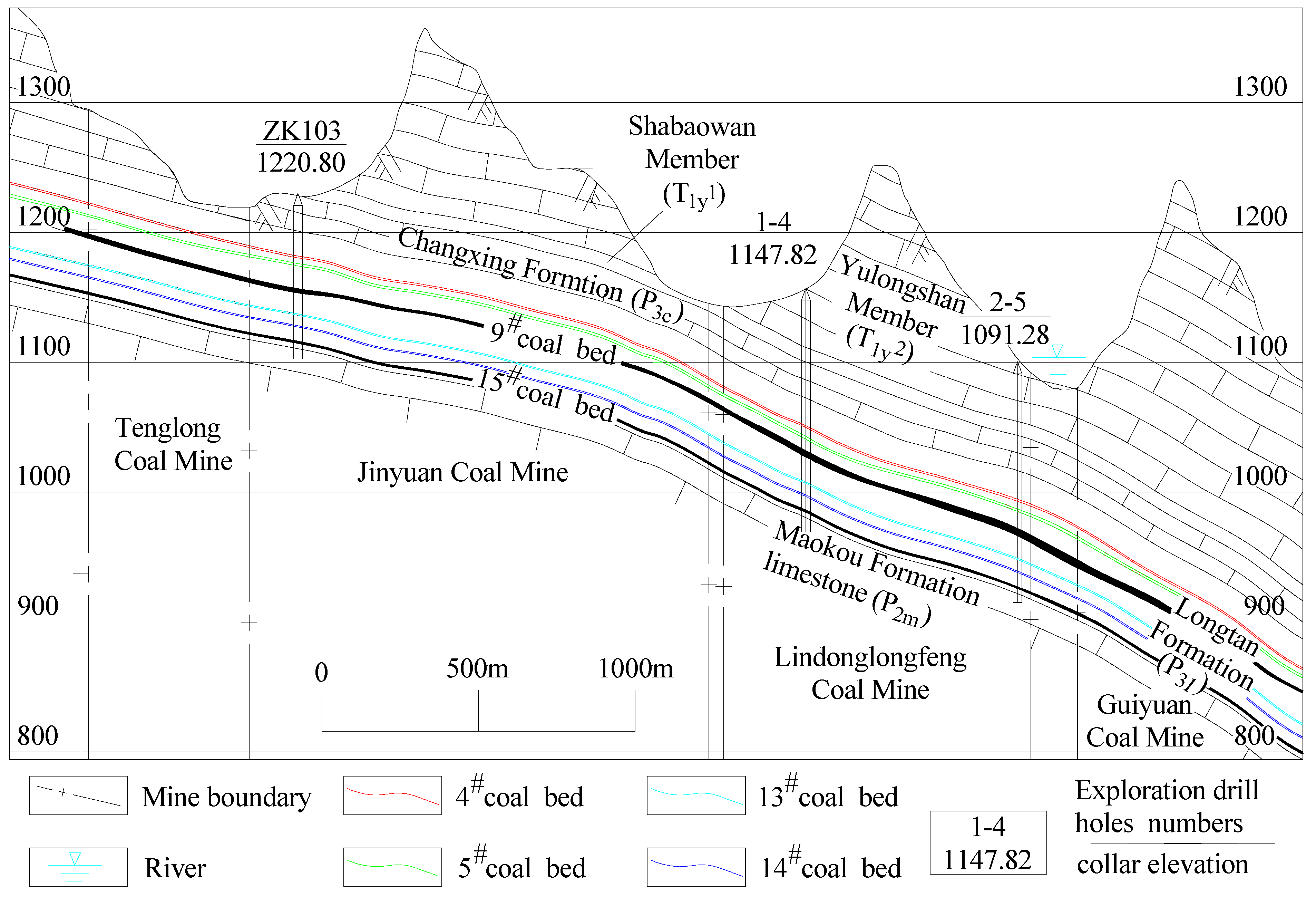
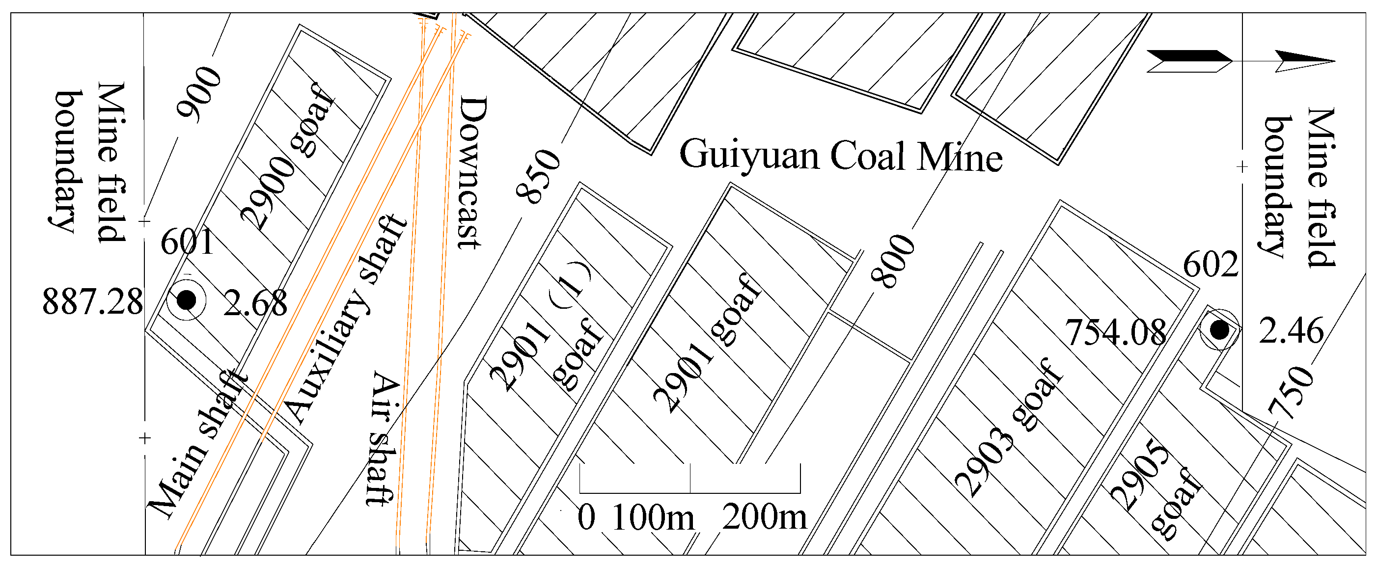
2.1. Overview of the Research Region

2.1.1. General Overview of the Mining Region

The Xinhua mining region (referred to as the mining region hereafter) is located in Jinsha County, Bijie city, Guizhou Province (Figure 1). Specifically, this region occurs southwest of Jinsha County and on the northwestern wing of the Jinsha Qianxi syncline, with a mining area of approximately 220 km2. There are currently 22 pairs of producing and developing coal mines in the mining region, with single-well design production capacities between 300,000 and 1.5 million tons per year and single-well field areas between 1.81 and 90.02 km2.

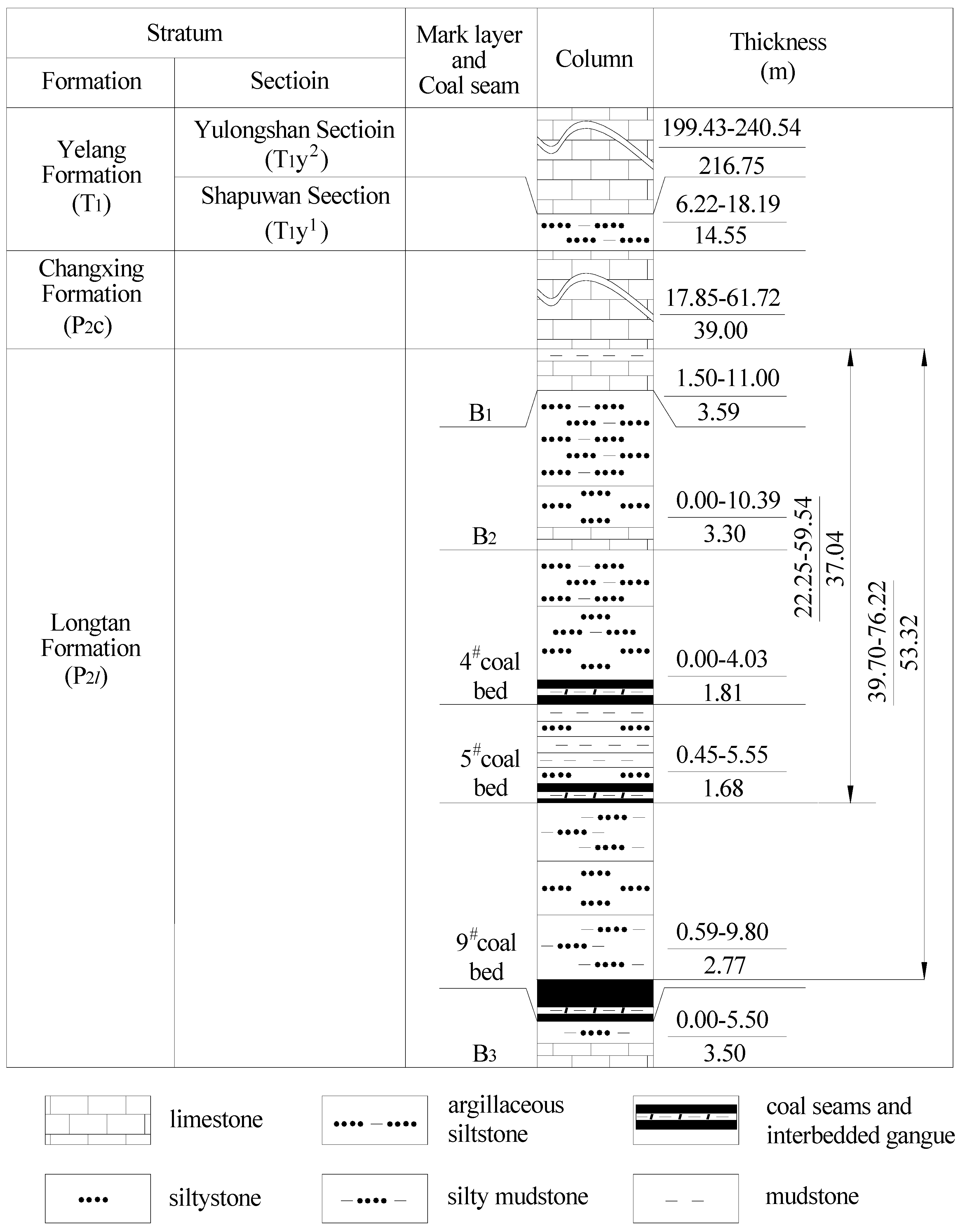
2.1.2. Geology of the Mining Region

The main coal-bearing strata that are mined (from oldest to youngest) include the middle Permian Maokou Formation (P2m), the upper Permian Longtan Formation (P3l), the Changxing Formation (P3c), the Lower Triassic Yelang Formation (T1y) and Maocaopu Formation (T1m), and Quaternary strata (Q). Among these strata, the coal-bearing layer is exclusively hosted in the Permian Longtan Formation (P3l).
The strata in the mining area exhibit an overall monoclinal structure, with local undulations forming secondary fold structures. The inclinations of the formation in the mining area range from 65 and 155°, with dip angles ranging from 0 and 27°, primarily between 5 and 10°. The coal mines in the mining region contain small exposed faults with production and construction areas of varying sizes, and some mines encompass collapsed columnar structures.
The Longtan Formation (P3l) in the mining region serves as a coal-bearing formation that comprises mainly gray to grayish-black thin- to medium-bedded siltstone, sandy mudstone, and argillaceous sandstone interbedded with fine sandstone, calcareous mudstone, and 4–7 limestone and argillaceous limestone layers. This formation hosts 12–15 coalbeds, including 2–6 mineable coalbeds, among which coalbeds 4, 9, and 15 are the principal mining coalbeds in most mines. The thickness of coalbed 9 ranges from 0.59 and 9.95 m (average: 2.77 m), and it is the main coalbed mined in most mines.

2.1.3. Hydrogeological Conditions in the Mining Region

The principal aquifers in the mining region are the Yulongshan Member (T1y2) limestone of the Triassic Yelang Formation, the Permian Changxing Formation (P3c) limestone, and the Permian Maokou Formation (P2m) limestone (Figure 2). The Yulongshan member (T1y2) limestone of the Triassic Yelang Formation is the primary aquifer, with thicknesses varying between 176.62 and 248.3 m (average of 211.92 m). The degree of karst development in this aquifer varies greatly, and the aquifer is classified as a weak to strong water-bearing aquifer. The Yulongshan member limestone is separated from the underlying coal-bearing strata by the Shapuwan member (T1y1) aquitard, with thicknesses ranging from 7.45 and 21.11 m (average: 14.91 m). The aquifers that can directly supply water to the Longtan Formation coal-bearing strata are the limestone aquifers of the overlying Changxing Formation and the underlying Maokou Formation. The Changxing Formation (P3c) limestone occurs in integrated contact with the Longtan Formation, with thicknesses varying between 17.85 and 61.72 m (average: 39.00 m) (Figure 3). Thirteen sets of pumping test data indicate that the aquifer is a weak water-rich aquifer. The thickness of the Maokou Formation limestone exceeds 200 m, with specific capacities ranging from 0.000915 to 0.148144 L/s·m. This limestone is classified as a weak to moderate water-rich aquifer. The coal-bearing strata of the Longtan Formation (P3l) contain numerous water layers and aquicludes, and the various lithologies within the strata are susceptible to mudification upon water exposure, which can cause the blocking of water-conducting channels.
The main groundwater sources are surface rivers and atmospheric precipitation, which infiltrate deep through surface outcrops for replenishment. The roof of the coal-bearing strata mainly receives water from the Changxing Formation and can indirectly receive water from the Yulongshan Formation limestone in the structural development area. The floor mainly receives water from the Maokou Formation limestone.
According to the exploration data from each mine field in the mining region and hydrogeological data covering the production period of the coal mines, the hydrogeological conditions in all the mines are similar. On the basis of a comprehensive analysis of exploration data from each coal mine, the coal deposit exploration type in the mining region is the first type within the third category, which refers to deposits with water-filled karst and simple hydrogeological conditions.
Since June 2016, when the 10903 working face of coalbed 9 in the Guiyuan Coal Mine began to experience water bursts, mines such as the Linhua Coal Mine, Jinji Coal Mine, Tenglong Coal Mine, Lindonglongfeng Coal Mine, and Anshenglongfeng Coal Mine have indicated water bursts originating from the roof of the working face of coalbed 9 [5,8,9,10], thereby seriously affecting the safety of mine production. According to mining data concerning the working face of coalbed 9 in these mines, the seam mining heights of coalbed 9 vary between 1.5 and 3.4 m. During normal production, the normal water inflow of the working face varies between 20 and 220 m3/h, and the sudden water inflow values generally vary between 80 and 800 m3/h.

2.2. Geological Data Collection and Analysis

Before and during the development of the mining region, researchers conducted large-scale geological surveys and constructed numerous survey boreholes. After the division of each mining field, workers in each coal mine conducted mine exploration work and established refined exploration drill holes; the exploration level was reached in each mining field; and reliable geological, hydrogeological and other geological technical data were provided for mine construction and production. Researchers collected geological data from 22 pairs of producing and developing coal mines at different production stages and analyzed the data. They studied the characteristics of geological and structural development and hydrogeological conditions via 348 boreholes already constructed in the mining area. Researchers recorded 10 cases of water bursts from the Changxing Formation limestone caused by faults and 12 cases of water bursts from normal geological blocks (refer to Table 1) and collected relevant data, such as the water burst location, mining height, structure of the water burst point, date of the water burst, burial depth and elevation of the water burst location, and maximum water burst volume for all working faces in all coal mines. The transient electromagnetic method was applied to measure abnormal water-rich changes in the top plate of the Changxing Formation limestone affected by mining (shallow, deep, and near-cut faces have all been mined) or unaffected by mining. The specific yield of the Changxing Formation limestone after mining-induced damage was investigated on the basis of static water burst recharge water data.

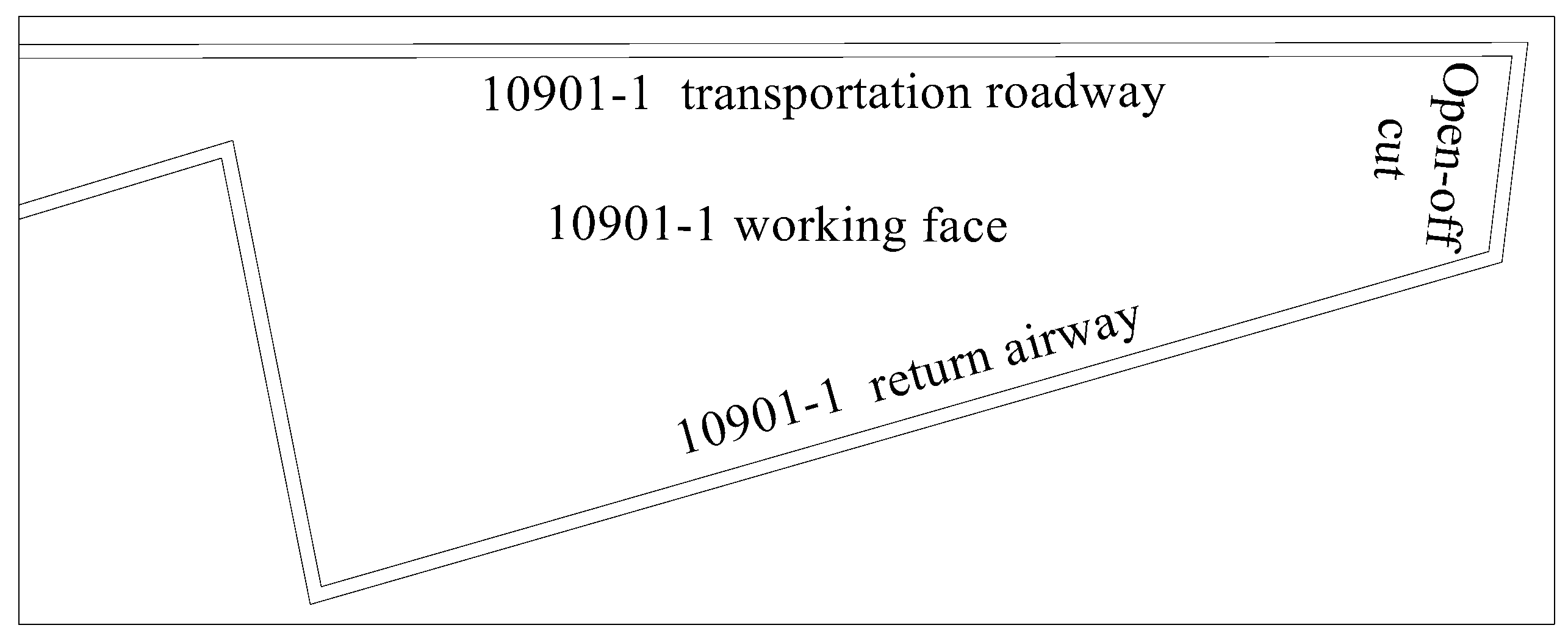
2.3. Research Methods for Analyzing the Roof Damage Height

2.3.1. Establishment of the Empirical Model

Theoretical calculations of the height of development of water-conducting fracture zones in China have provided a large amount of relevant statistical data. Researchers have adopted statistical methods to study and measure the height of development of water-conducting fracture zones under various rock settings. On the basis of the presence of coalbeds and their roofs within the research region, an empirical model to determine the height of development of water-conducting fracture zones was established. The relevant equation in the Code for Retaining Coal Pillars and Coal Mining in Buildings, Water Bodies, Railways, and Main Mines [26] was employed to calculate the height of the water-conducting fracture zone. The rocks between coalbed 9 and the Changxing Formation limestone in the mining region comprise mainly argillaceous siltstone, silty mudstone, and siltstone (Figure 3), with average compressive strengths of 35.74, 30.75, 43.90, 46.73, and 53.72 MPa. The strata between coalbed 9 and the Changxing Formation limestone are primarily medium-hard rocks (the uniaxial compressive strength ranges from 20 to 40 MPa, and the rock types are sandstone, argillaceous limestone, sandy mudstone, and mudstone). Therefore, the height of the water-conducting fracture zone can be calculated as follows:
H li = 100 M 1.6 M + 3.6 + 5.6
where Hli is the height of development of the water-conducting fracture zone (m), and M denotes the cumulative thickness of the coalbed (m).

2.3.2. Simulation of the Water-Conducting Fracture Zone Height

The simulation of similar materials is an important research method for solving geological engineering problems in coal mines. A model that represents the geological strata in the research area was created in the laboratory on the basis of similar materials. With the help of the established model, the changes in the simulated strata during coalbed mining can be observed, and the heights of roof rock collapse and fracture development after coalbed mining can be determined, thereby obtaining the mining failure height, strata movement evolution, and stress distribution state during mine production. This research method provides the advantages of intuitiveness, simplicity, economy, speed, and a short experimental period. Therefore, on the basis of the characteristics of the distribution of water burst-affected mines in the mining region, a similar-material simulation experiment was conducted focused on the water burst-affected 10901-1 working face of the Guiyuan Coal Mine. The 10901-1 working face is located in the first mining district of the Guiyuan Coal Mine. The working face is bordered by the deep 10903 goaf in the north, the southern and eastern sides are mine boundaries, and the western side is the 10901 goaf. The corresponding surface of this working face comprises barren mountains without rivers, lakes, or other water bodies. The 10901-1 working face is an irregular polygon (Figure 4) with an average strike length of 630 m and a dip length of 110 m. The average dip angle of the coalbed is 7°, and the mining thickness of the working face is 3.00 m. The average burial depth of coalbed 9 in this working face is 389 m, the thickness of the Changxing Formation limestone aquifer in the roof is 39.48 m, and the average distance between the floor of the Changxing Formation limestone and coalbed 9 is 42.81 m.
On the basis of the mining conditions of the coalbed in the working face, a similar-material simulation model with dimensions of 250 cm (length) × 20 cm (width) × 140 cm (height) was established at a ratio of 1:150. According to the empirical values of the height of the water-conducting fracture zone, the rock layer of interest in the model was determined as the rock layer below the limestone in the Yulongshan member. Owing to the limited height of the experimental equipment, the strata from the top rock layer to the surface were subjected to loading. The model is shown in Figure 5.
On the basis of the lithological characteristics of the simulated working face and the physical-mechanical properties of the rock strata, similar simulation materials were proportioned according to the geometric similarity coefficient and the designated material mix ratio. The materials selected for the test model are fine sand, which is used as an aggregate; calcium carbonate and gypsum, which are used as bonding materials; and mica powder, which is employed as a weak interlayer surface material. The fine sand contents in the various rock types vary between 30% and 70%, the calcium carbonate contents vary between 12% and 49%, and the gypsum contents vary between 9% and 30%. The mechanical parameters of the coalbed and various types of rock strata, as well as the corresponding proportions of similar materials, are provided in Table 2.

2.3.3. Ground Exploration via Drilling

After coalbed mining, the surrounding roof of the working face is damaged, resulting in a circular crack. Via ground drilling, it is possible to investigate the water leakage and rock fragmentation conditions in the fracture zone, thereby obtaining the development height of the water-conducting fracture zone after coalbed mining [27]. To study the development height of water-conducting fractures, in the later supplementary exploration process of the mine, two exploration boreholes, i.e., 601 and 602, were designed and constructed above the 2900 working face and 2905 goaf in the Guiyuan coal mine. The holes were positioned 17.1 and 8.5 m, respectively, from the edge of the goaf to determine the height of the water-conducting fracture zone formed after the mining of coalbed 9 (Figure 6).
The 2900 and 2905 working faces are located in the second mining district of the Guiyuan Coal Mine, with inclined lengths of 108 and 136 m, respectively. Fully mechanized mining technology was adopted for the working face, with full-height mining implemented once and the full-collapse method employed for roof management. Coalbed 9 was mined from these two working faces, with mining heights of 2.68 and 2.46 m, respectively. The roof rock of the two working faces comprises mainly siltstone, silty mudstone, and argillaceous sandstone.

3. Study on the Damage Characteristics of the Changxing Formation Limestone After Coalbed Mining

3.1. Research on the Height of the Mining-Induced Fracture Zone

3.1.1. Calculation of the Empirical Model

The distances between coalbed 9 and the Changxing Formation limestone range from 39.70 to 76.22 m (average: 53.32 m). In the water burst-affected coalbed, the mining height of coalbed 9 varies between 2.3 and 3.4 m. According to Equation (1), the heights of the water-conducting fracture zones in the mining region vary between 37.2 and 42.8 m. According to the results obtained with Equation (1), combined with the distance between coalbed 9 and the Changxing Formation limestone as well as the analysis of the data provided in Table 3, the water-conducting fracture zones in most mines cannot penetrate the Changxing Formation limestone after the mining of coalbed 9, and mining is unlikely to cause damage to the Changxing Formation limestone. Therefore, further research on the development characteristics of the water-conducting fracture zone in coalbed 9 is necessary to explain the mechanism underlying water bursts from the Changxing Formation limestone after mining damage.

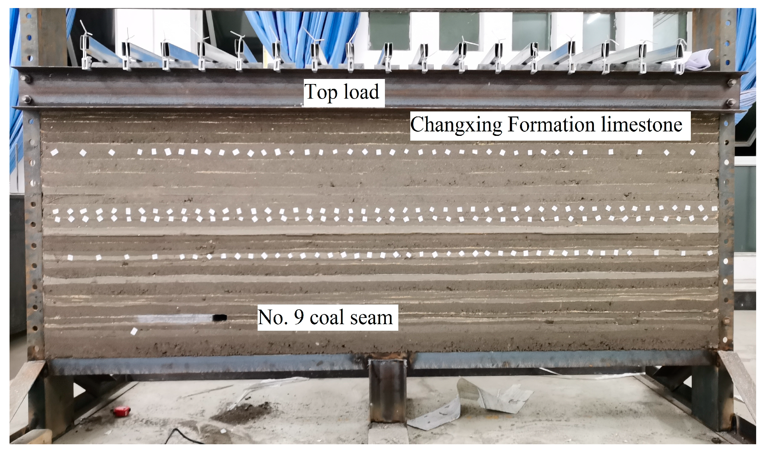
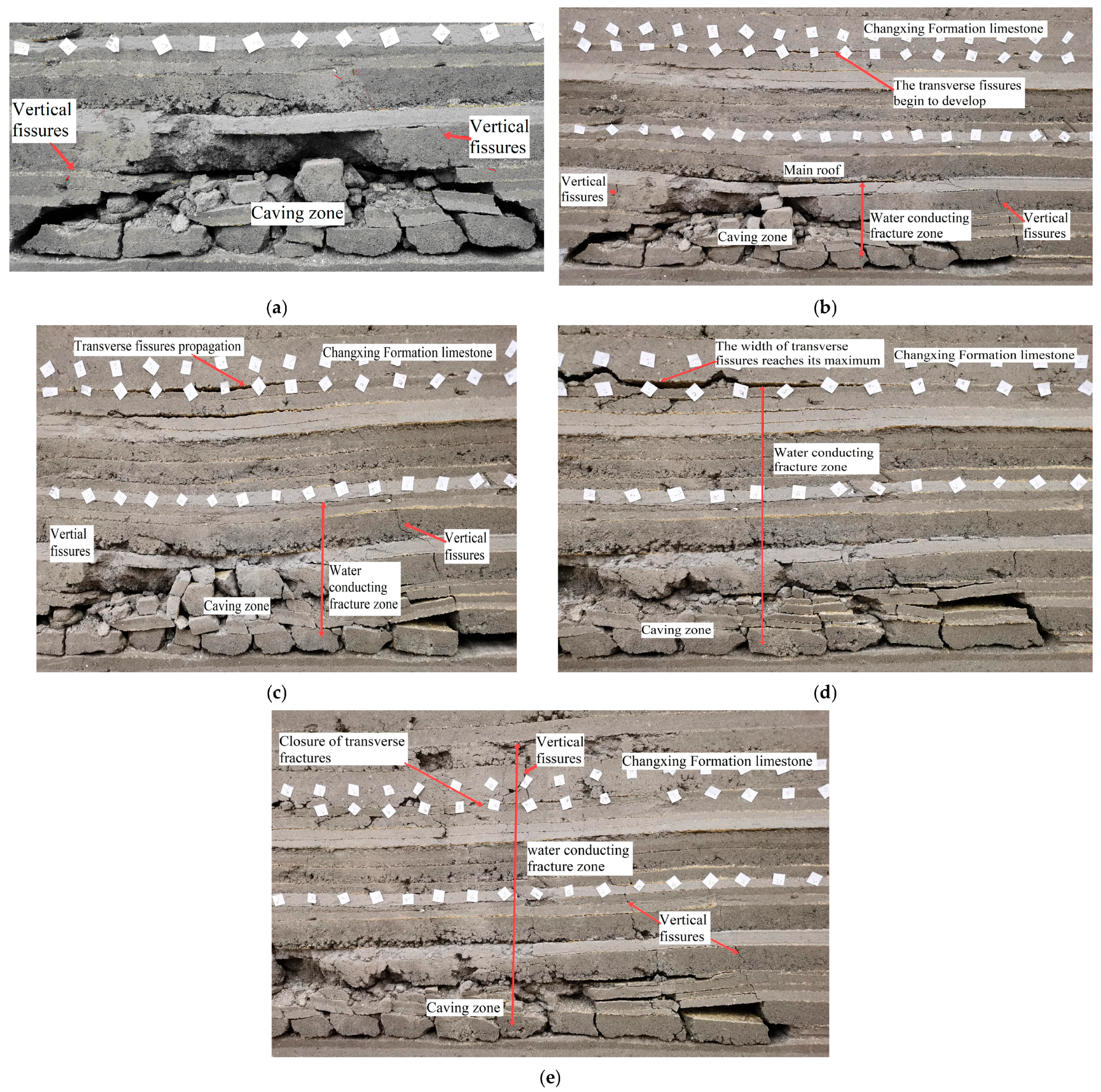
3.1.2. Results of the Simulation of Similar Materials

The coalbed was mined according to the experimental design, and the experimental results revealed the process and mechanism of roof failure after coalbed 9 mining. After the implementation of mining from the open-off cut of the working face, the overlying roof rock layer lost the support of the underlying rock layer and experienced bending deformation under its self-weight stress. Once the limit of the tensile strength of the rock layer was reached, the layer was fractured and yielded a goaf caving zone. At this time, roof mining fractures occurred mainly on both sides of the goaf boundary (Figure 7a). With the increasing area of the goaf, the deformation caused by mining movement was transmitted from bottom to top, and mining fractures developed upward. When the working face advanced to 89 m, transverse fissures began to form at the bottom of the hard limestone layer in the Changxing Formation. The vertical fissures were controlled by the main roof and developed at a height that lagged behind that of the transverse fractures. At this time, the height of the water-conducting fracture zone reached 19.8 m (Figure 7b). Once the working face advanced to 106 m, the fine sandstone main roof in the upper part of the goaf was fractured, and the weak rock layer (forming a composite beam structure) in the upper part of the main roof experienced synchronous settlement. Afterward, the transverse fissures at the bottom of the Changxing Formation limestone layer expanded, and the height of the vertical fissures gradually increased. The height of the water-conducting fracture zone reached 33.2 m, as shown in Figure 7c.
As the working face continued to advance to 150 m, the width of the transverse fissures reached its maximum value of 1.7 m. Vertical fissures also developed into the floor of the Changxing Formation limestone, with the height of the water-conducting fracture zone being 42.81 m (Figure 7d). Afterward, the width of the transverse fissures gradually decreased. Once the working face advanced to 179 m, the length of the goaf reached the limit breaking distance of the limestone, and the Changxing Formation limestone was fractured. The transverse fissures closed, causing the water-conducting fracture zone to penetrate into the Changxing Formation limestone body, as shown in Figure 7e. At this point, the vertical fissures far from the edge of the goaf were mostly closed, whereas those near the edge of the goaf remained open and developed into the middle-upper section of the Changxing Formation limestone. The final measured height of the water-conducting fracture zone was 77.33 m, with a ratio of 25.78 to the mining height. The water-conducting fracture zone extended into the Changxing Formation limestone, resulting in failure.

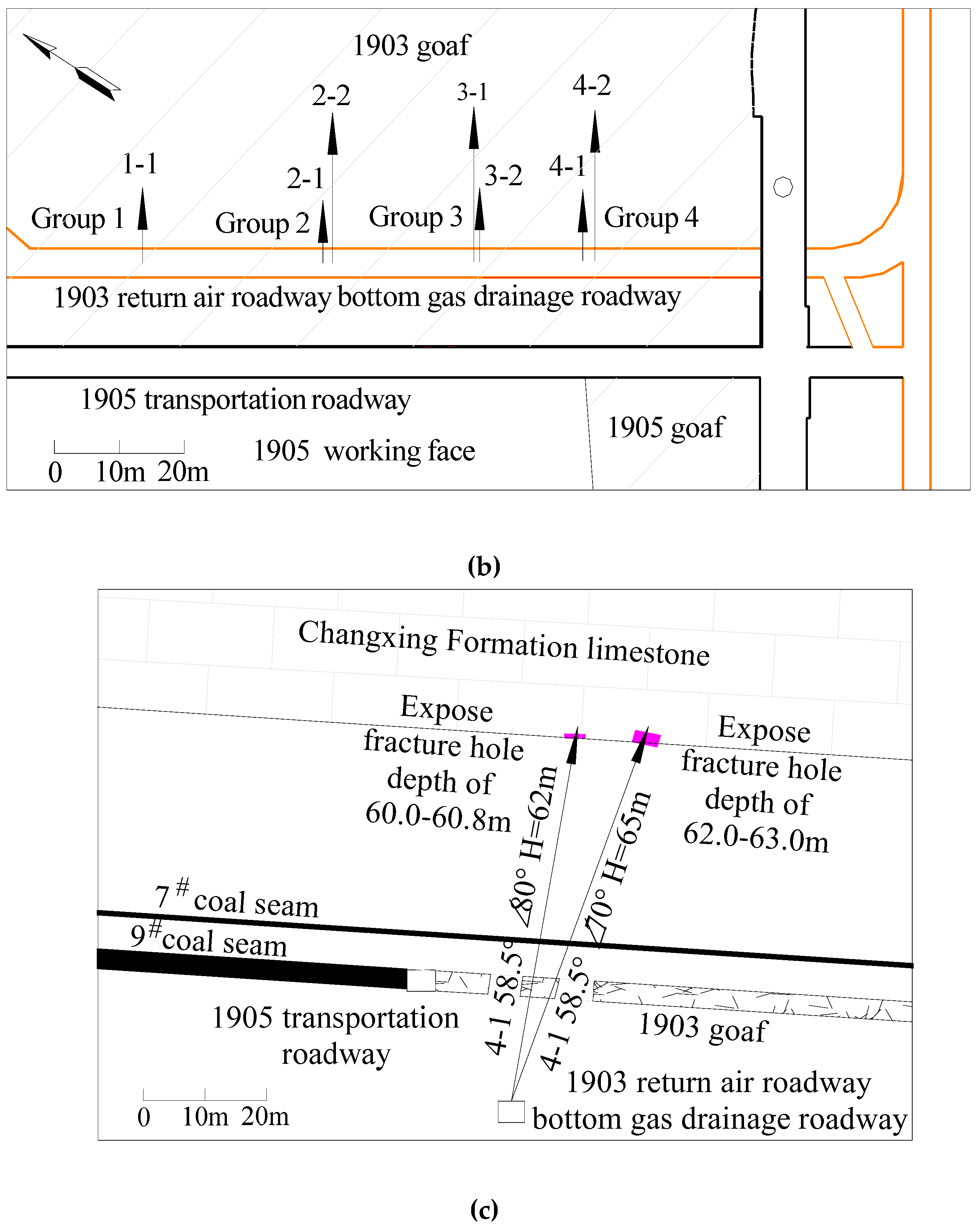
3.1.3. Ground Drilling-Based Measurement of the Height of the Water Conducting Fracture Zone

In the supplementary exploration process during the normal production period of the mine, both the 601 and 602 boreholes constructed in the Guiyuan Coal Mine contained the Yelang Formation (T1y), Changxing Formation (P3c), and Longtan Formation (P3l) strata, and these boreholes terminated in the Maokou Formation (P2m) limestone and the floor of coalbed 9, respectively. The drilling depths were 345.11 m and 414.50 m, respectively. The two boreholes revealed the goaf of coalbed 9, and the mining heights of the working faces were 2.68 and 2.46 m, respectively. The distances between coalbed 9 and the Changxing Formation limestone were 41.2 and 43.3 m, respectively. The 601 and 602 exploration boreholes for the water-conducting fracture zone revealed water leakage throughout the entire layer of the Shabaowan member of the Yelang Formation (T1y1) and the strata of the Changxing Formation limestone. The exploration results of these two boreholes indicated that at the edge of the goaf, the mining damage height significantly increased, with the maximum height of the water-conducting fracture zone exceeding 43.3 m. Moreover, mining damage affected the entire Changxing Formation limestone. The working faces in the Linhua Coal Mine, Tenglong Coal Mine, Guiyuan Coal Mine, Anshenglongfeng Coal Mine, and other coal mines in the mining region have experienced water bursts originating from the limestone roof near the open-off cut, long-term stopping position, stress concentration area, etc., which verifies the accuracy of the borehole exploration results and relevant research results [3,28].

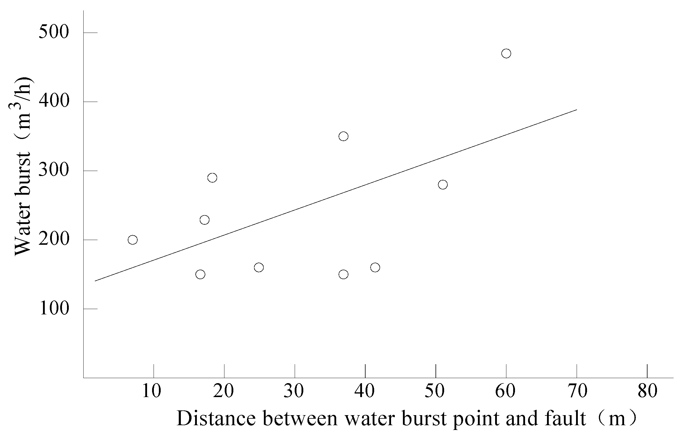
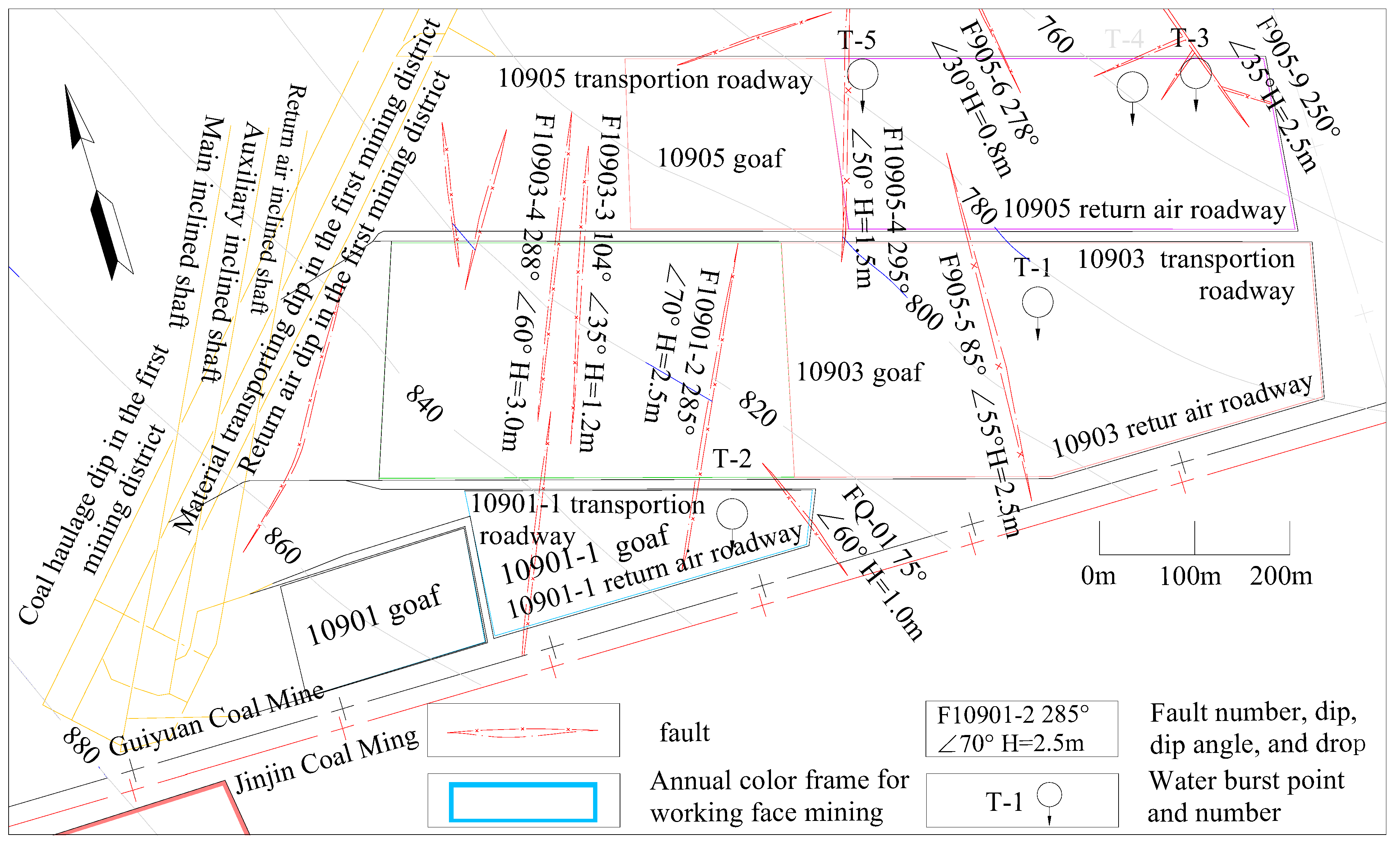
3.2. Fault Rerupture

Faults can serve as both spaces for water storage and channels for conducting water bursts. Water bursts in fault zones are among the major hazards that pose a threat to safe coal mine production [4,29,30]. When water bursts occur in the working face, the activation of faults can lead to the formation of unobstructed water channels, which is often an important factor leading to water bursts. This is also an important reason why the working face does not experience water bursts during roadway construction but rather during mining [31,32]. In the process of advancing the working face, mining movement-induced stress causes the redistribution of rock mass stresses within a certain range along the advancing direction of the working face, thus forming a stress concentration zone. Owing to the disruption of the integrity of the rock layer due to fault cutting, abnormal stress occurs in the fault zone during mining activities, resulting in sliding between the hanging wall and the footwall of the fault, increased fractures between fault zones, and other phenomena, causing the fault zone and fractures near the fault to become water channels [33,34,35,36,37,38,39,40]. In such situations, the fault zone in the coalbed roof, the fault-associated fracture zone, and the water-conducting fracture zone in the roof become interconnected with the water-filled aquifer. This causes water inflow from the aquifer into the stope.
Owing to the damage caused by the fault, the fissures in the Changxing Formation limestone are more notably developed than those in the normal geological blocks are, and the water-rich properties of the Changxing Formation limestone are relatively favorable. The combination of mining-induced fractures and fault zones increases the connectivity among the primary fractures, dissolution fissures, and karst caves in the Changxing Formation limestone. The superposition of their effects not only increases the water storage capacity of the Changxing Formation limestone in the goaf roof but also causes rapid and large-scale water bursts in the working face. With an increasing number of faults exposed in the working face, the frequency of water bursts increases accordingly, as detailed in Table 1. Notably, three water burst events caused by faults in working faces 10905 and 2093 occurred in the Guiyuan Coal Mine, which is far greater than the number of water bursts in the working faces of the normal geological blocks.
To date, 22 water burst events have occurred in the mining region (Table 1), among which 10 have occurred near faults, accounting for 45.45% of the total. The length of the water burst-affected fault exposed in the mining region decreased by 0.6–2.5 m, and the distance between the water burst point and the fault ranged from 7.0 to 60.0 m (Table 4). The water burst volume was significantly correlated with the distance between the water burst point and the fault (refer to Figure 8 and Equation (2)), with a correlation coefficient R of 0.61 [41,42]. Before the occurrence of a water burst in the working face, dripping and water seepage phenomena were observed in the roof, accompanied by significant increases in the roof pressure and pressure in the old roof. There have been 10 water burst events in the Guiyuan Coal Mine, among which eight water burst points occur near the working face fault. The distances between the water burst points and the fault range from 16.6 to 60.0 m (Figure 9), and the water burst volumes range from 150 to 470 m3/h.
q = 3.8207X + 128.39 (R2 = 0.3742)
where q is the water burst volume, m3/h, and X denotes the distance from the water burst point to the fault, m.

4. Study on the Water-Rich Characteristics of the Changxing Formation Limestone After Mining Damage

4.1. Water-Rich Characteristics of the Limestone in Its Original State

Karst terranes cover approximately 15% of the Earth’s surface [43]. The South China karst region, where Guizhou Province is located, is one of the world’s three major karst distribution areas and the primary karst region in China [4,44]. The Changxing Formation limestone remains stable in various coal-bearing areas of Guizhou Province. Under the combined influence of geological tectonic movements and external environmental factors, the brittle-structure Changxing Formation limestone formed dissolution pores, caves, fractures, and joints of varying scales [40]. The connectivity between these features determines the water-rich (permeable) characteristics of the Changxing Formation limestone. Geological exploration drilling was conducted before the construction of each mine, and a total of 268 boreholes were drilled in the Changxing Formation limestone. Notably, the maximum linear karst rate revealed by the boreholes was 0.8%. Locally developed karst caves were found in the limestone, with drilling revealing cave heights between 0.18 and 8.74 m. Some caves are filled with yellow clay. Some boreholes penetrating this limestone leaked water, with a leakage rate of 17.5%. The depth of the leakage points was shallow, at 367.4 m, and the lowest elevation reached 922.16 m.
The pumping test data from all the coal mines indicated that the only borehole (Linhua Coal Mine) in the Changxing Formation limestone exhibits a specific capacity (q) of only 0.1418 L/m·s, whereas the other boreholes exhibited values varying between 0.0000041 and 0.0127 L/m·s. The permeability coefficient K was measured in only one borehole via a pumping test, at 0.1079 m/d, and all the other boreholes yielded values between 0.0000026 and 0.004 m/d. Therefore, the Changxing Formation limestone can be classified as a weak water-rich (permeable) aquifer [45,46], with a low connectivity of dissolution gaps and low water conductivity. Karst has developed in the structural development area, with favorable water abundance, and there may be a large amount of water inflow during production. The amount of water inflow in the initial mining face in various coal mines was relatively small, generally less than 30 m3/h, which verifies the water-rich characteristics of the Changxing Formation limestone. According to the data obtained with the transient electromagnetic method for the roofs in the mining faces of various coal mines, the absence of mining in the adjacent mining face of the upper section indicates the general lack of water-bearing capacity in the limestone. The lower sections of the 20915 and 20917 working faces in the Linhua Coal Mine have been fully mined, and there is no goaf in the upper section. The transient electromagnetic method was applied to identify the abnormal water-rich area in the two layers in the roof of the working face, and no significant water-rich anomalies were found in the Changxing Formation limestone. Afterward, 42 boreholes for the exploration and drainage of the Changxing Formation limestone were constructed in the mine, but no water emerged from these exploration and drainage boreholes.
On the basis of comprehensive analysis, the Changxing Formation limestone is generally an aquifer with a low water yield potential in its original state, with the limited connectivity of dissolution gaps and low permeability. Karst is present in the structural development area, with suitable water abundance, and water bursts may occur during mining. Outcrops of the Changxing Formation limestone are widely distributed across the mining region, rendering the limestone susceptible to atmospheric precipitation recharge.

4.2. Water-Rich Characteristics of the Changxing Formation Limestone After Mining Damage

After more than 20 years of continuous mining operations in coal mines, coalbed 9 near the shallow outcrop has been completely mined, and in some coal mines, coalbeds 4 and 5 have already been mined. A large goaf area has formed near the shallow coalbed outcrop in the mining region. Extensive mining-induced damage has resulted in large-scale surface fracture zones. Some mines and the exposed Changxing Formation limestone contain fractures with widths ranging from 0 to 2.3 m and extension lengths ranging from a few meters to more than 100 m. During the exploration of various coal mines in the mining region, the maximum width of the fissures in the Changxing Formation limestone exposed by drilling was 3 cm, and the maximum height of the karst caves reached 8.74 m. Mining-induced damage has led to the development of internal fractures in the Changxing Formation limestone that connect the original dissolution fissures, karst caves, and fractures in this limestone [1,4,6], thus forming a very large effective water storage space (Figure 10). With the massive infiltration of atmospheric precipitation, the Changxing Formation limestone in the goaf roof strata, under the condition of water storage, has gradually become the direct or indirect water-filling source for the stope across the mining area, and this fractured aquifer now serves as the direct water source for bursts during coalbed mining. The Changxing Formation limestone under shallow conditions serves as both a water storage space for infiltrated atmospheric precipitation and an atmospheric precipitation supply channel for the stope below. During the water burst period of the working face, the process phenomena are typically accompanied by periodic roof weighting and exhibit a progressive evolution from dripping water to steady seepage and eventually water burst occurrence. Moreover, after the working faces are mined through the water burst points, the water inflow of the goaf gradually decreases and stabilizes. Water bursts may occur again in the next working face or in specific sections of this working face.
To investigate the characteristics of the changes in the water-rich Changxing Formation limestone in the affected area after coalbed mining, underground transient electromagnetic exploration work was conducted after the development of the lower section or adjacent working faces in the Tenglong Coal Mine, Guiyuan Coal Mine, Linhua Coal Mine, and Anshenglongfeng Coal Mine. These surveys aimed to explore abnormal water-rich areas in the roof limestone of the working face. Among these areas, the abnormal water-rich area of the Changxing Formation limestone in the 2098 (east) mining face of the Linhua Coal Mine was particularly obvious. The 2098 mining face (east) is located on the eastern wing of the second mining district, with the upper section of the 2096 mining face (west), the 2094 working face, and the lower section of the 20910 working face already fully mined. The strike length of this working face is 482 m, the inclined length (width) is 150 m, and the coalbed thickness ranges from 0.7–3.3 m. After the formation of the working face, transient electromagnetic detection was promptly implemented in the return airway, roadway, and cut eye. Transient electromagnetic detection of the working face revealed the presence of four water-rich anomaly zones in the roof, i.e., YC1, YC2, YC3, and YC3 (Figure 11), all of which developed in the Changxing Formation limestone, and the spatial development characteristics of each water-rich anomaly zone are detailed in Table 5. The water-rich anomaly zones 1 and 2 are caused by the mining impacts of the 20910 and 2098 working faces. Water-rich anomaly zone 3 may have been caused by the accumulation of water in karst caves that developed in the Changxing Formation limestone. For example, in the Anshenglongfeng Coal Mine, the bottom gas drainage roadways of the 1903 and 1905 working faces were adopted as drilling sites (Figure 12), and four sets of seven drainage boreholes were drilled into the Changxing Formation limestone in the top plate of the 1903 goaf. The seven boreholes that exposed the Changxing Formation limestone all revealed the development of mining-induced fractures in this limestone. The lengths of the longest and smallest fractures exposed by the boreholes ranged from 0.2 to 1.0 m, and the widths of the fractures typically varied between 0.2 and 0.5 m. The boreholes that revealed the Changxing Formation limestone all experienced water inflow, with the maximum water output reaching 50 m3/h. The geological, hydrogeological, and transient electromagnetic data measured underground indicated that after mining damage, fractures developed within the rock mass of the Changxing Formation limestone, and the fractures were connected to the original dissolution fissures and karst caves. The Changxing Formation limestone provided space for water storage. Consequently, this limestone became a source for mine water bursts.

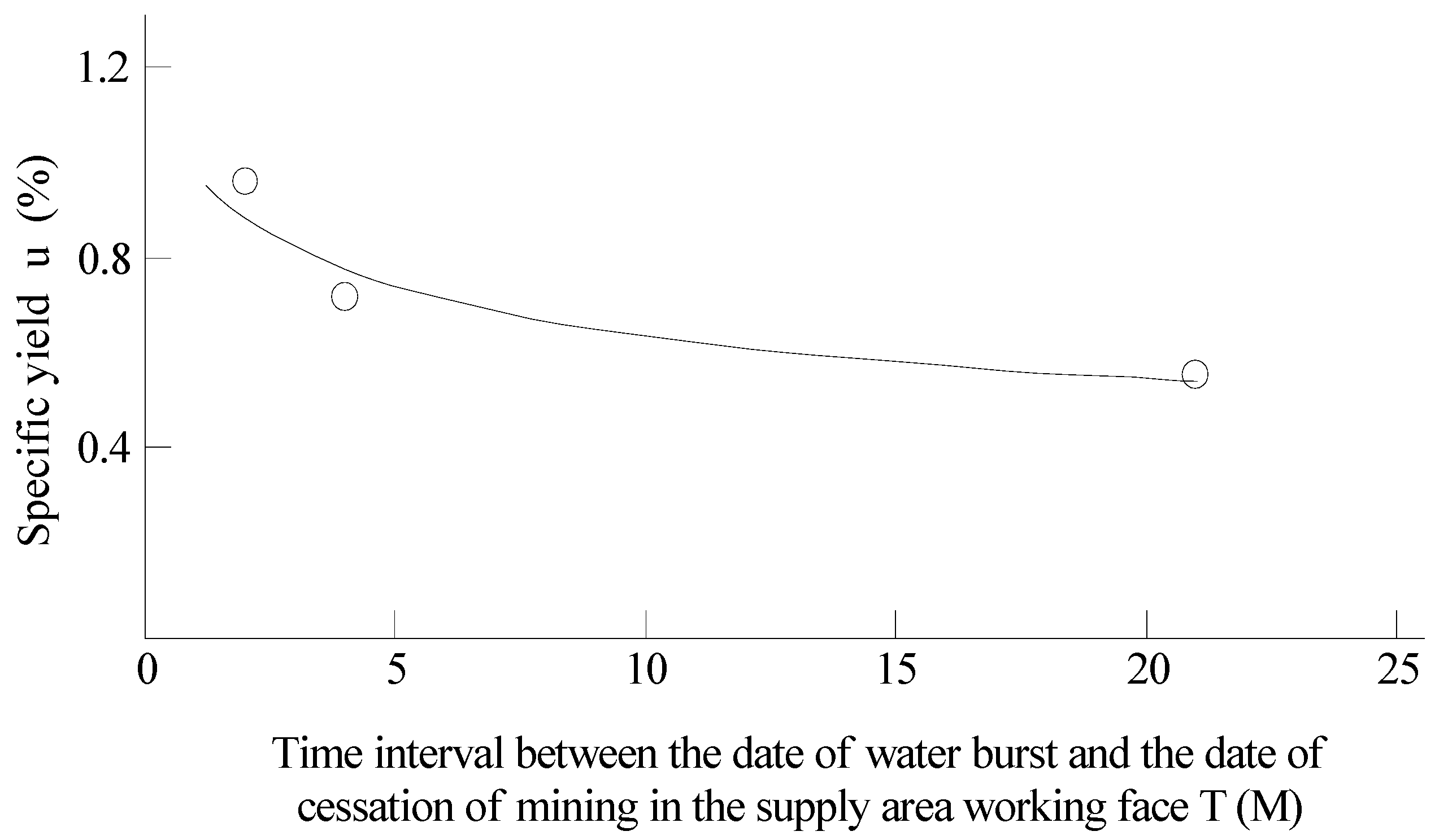
4.3. Characteristics of the Variation in the Specific Yield After Mining Damage

The specific yield refers to the ratio of the volume of water released from an aquifer under the action of gravity to the volume of the medium. Alternatively, the specific yield is the ratio of the amount of water that is freely drained from a saturated aquifer per unit area under the action of gravity to the volume of the aquifer. It is an indicator for evaluating the performance of the water supply of aquifers [47,48,49,50]. If all the voids in the rock are filled with water, the water content is equal to the void content. However, in reality, owing to poor connectivity between voids, closed voids that cannot accommodate water can occur, or there are bubbles in the voids after filling, so the water content is usually less than the void content. The specific yield u is the ratio of the volume Vn of the rock voids that can accommodate water to the volume (V) of the rock, expressed as u = Vn/V, which is expressed in percentages or decimals. In the mine production process, the ratio of the static water storage released by the aquifer to the volume of the aquifer, i.e., u = Qs/V, can be used to calculate the specific yield of the aquifer.
The voids in the Changxing Formation limestone after the occurrence of mining damage encompass the original dissolution fissures, karst caves, fractures, and newly formed mining-induced fractures. The first three elements are connected by fractures caused by mining damage, thereby forming an effective water-bearing space for the Changxing Formation limestone to supply the mine with water and establish supply channels for shallow water sources. In the process of supplying the mining area with water from the Changxing Formation limestone, the initial water inflow originated from static storage and dynamic recharge, whereas the later inflow into the mining area originated from a dynamic water supply. The ratio of the static storage water released by the aquifer to the total volume of the Changxing Formation limestone affects its water yield. To more accurately predict the possible water burst volume and intensity for the next section of the working face, complete water burst data were collected from three pairs of mine working faces in the Anshenglongfeng Coal Mine, Guiyuan Coal Mine, and Lindonglongfeng Coal Mine, and specific yields were calculated.
The 1903 working face is the first mining panel in the Anshenglongfeng Coal Mine, and the adjacent 1905 working face is the second mining face. The water burst source for the 1905 working face was water from the Changxing Formation limestone in the roof of the goaf after the occurrence of mining damage to the 1903 working face. Therefore, via the use of both the water burst volume of the 1905 working face and the volume of limestone damage caused by mining in the goaf roof of the 1903 working face, the specific yield of the Changxing Formation limestone after mining damage can be calculated. This result enables the evaluation of the water-rich characteristics of the Changxing Formation limestone and provides technical data for predicting water inflow in future working faces. On the basis of the water burst volume and Changxing Formation limestone volume parameters (Table 6) from the three pairs of working faces in the different coal mines, the specific yield was calculated as follows:
Table 6. Statistics of water bursts and the volume fraction of the Changxing Formation limestone.
MineWater Burst-Affected Working FaceWater Burst Inflow (Static Replenishment Quantity Qs) (m3)Supply Goaf Area (m2)Thickness of the Changxing Formation Limestone (m)Changxing Formation Limestone Volume V (m3)Water Burst Time of the Working Face (Day, Month, Year)Latest Production Stoppage Time of the Goaf (Month, Year)
Anshenglongfeng
Coal Mine
1095101,337271,29038.3710,588,44412 April 2023February 2023
Guiyuan
Coal Mine
10901-176,00010,630,88544.1110,635,88525 February 2019August 2018
Lindonglongfeng
Coal Mine
591443,260195,52140.007,820,84024 March 2020May 2018
Q = Qs + Qd
Qs = Q − Qd
Thus:
u = Qs V
where Q is the total water inflow at the water burst point, m3; Qs is the static storage capacity of the aquifer, m3; Qd is the dynamic recharge volume of the aquifer, m3; u is the specific yield; and V is the volume of the aquifer, m3.
According to the data provided in Table 6, the specific yield of the Changxing Formation limestone in the goaf of working face 1903 in the Anshenglongfeng Coal Mine is 0.957%, that of the Changxing Formation limestone in the recharge area of working face 10901-1 in the Guiyuan Coal Mine is 0.715%, and that of the Changxing Formation limestone in the recharge area of working face 5914 in the Lindonglongfeng Coal Mine is 0.553%.
According to data analysis, the shorter the interval T (time unit: month; abbreviated as M) between the water burst time and the end time of mining the face is, the greater the specific yield, and vice versa (Figure 13). The magnitude of the specific yield is significantly related to the interval between the water burst time and the end time of mining the face corresponding to the overlying Changxing Formation limestone, and the two are exponentially correlated. The regression equation is as follows:
u = 1.0513d−0.2189 (R2 = 0.9293)
The correlation coefficient R is 0.964, indicating a high degree of correlation between the two parameters [51,52].
The water burst date of working face 1095 in the Anshenglongfeng Coal Mine is only 2 months after the end date of mining of working face 1093. The specific yield of the Changxing Formation limestone is the highest, at 0.957%. The water burst date of working face 5914 and the end date of mining of working face 5917 in the Lindonglongfeng Coal Mine differ by 21 months. The specific yield of the Changxing Formation limestone is the lowest, at 0.553%. The water burst date of working face 10901-1 in the Guiyuan Coal Mine differs from the completion date of backfilling in the supply area by 4 months, and the specific yield of the Changxing Formation limestone is 0.715%, which is between the values of the two panels mentioned above. These findings indicate that the Changxing Formation limestone exhibited a natural tendency of fracture closure over time after mining damage. In addition, the sedimentation and filling of loess particles and other debris in the water source reduced the effective water storage space. An increase in sedimentary particles not only causes poor water flow in the supply channel but also gradually decreases the water inflow of the goaf [4]. In addition, the loess particles that are deposited and fill cracks in this process also constitute the root cause of the influx of loess slurries in some coal mines in the early stage of water bursts [10].
Figure 13. Curve of the specific yield: Time interval between the date of the water burst and the date of the end of mining at the working face in the supply area.
Water 17 02264 g013

5. Application of the Research Results

5.1. Design Optimization of the Working Face

After the extraction of the upper section of the working face of coalbed 9, mining damage-induced fractures and primary dissolution fissures, karst caves, and fractures in the overlying Changxing Formation limestone strata in the goaf roof jointly provided a large effective water storage space. During the mining of the next section of the working face, when the water-conducting channel becomes connected with the Changxing Formation limestone, water bursts can occur in the working face. Before the occurrence of water bursts from the Changxing Formation limestone caused by mining damage, a downward arrangement of working faces was adopted in all the coal mines within the Xinhua mining region. Therefore, the underground water stored in the Changxing Formation limestone caused by shallow working face damage could smoothly recharge the the roof Changxing Formation limestone in the lower section, leading to water bursts in the next section of the mining face. After the completion of mining at the 2094, 2096, and 2098 working faces of the Linhua Coal Mine, roof water bursts occurred successively in the lower sections of the 20910 and 20912 working faces during the mining period. Mine management subsequently altered the design of the working face by gradually adjusting the mining sequence and transitioning from a downward mining face to an upward mining face, thereby avoiding the phenomenon of water bursts from the working face. For example, the upper limit of working face 2096 (east) was mined in 2023 after the completion of mining in the lower sections of working faces 20910, 20912, 20914, etc., and no water burst occurred during the mining period of this working face.

5.2. Enhancing the Disaster Resistance Capability of the Drainage System

Before water bursts occurred in the working face of each coal mine and because the normal water inflow of the working face was less than 30 m3/h, the drainage capacity of the drainage pump and drainage pipeline normally installed in the working face was approximately 50 m3/h. After water burst occurrence, the transportation roadway of the working face was often flooded by the inflowing water, causing the production of the working face to stop temporarily. When designing the working face in the next section, each mine must aim to estimate the water inflow and water burst volume of the new mining face on the basis of the water burst volume of the working face. Before water inrush occurred, the water inflow of the working faces typically ranged from 20 to 30 m3/h. After water inrush incident occurrence, the maximum water burst volume at the working faces reached 80–800 m3/h. Therefore, on the basis of the maximum burst volume, personnel of some mines predicted the water burst volume for the upcoming mining face by applying the upper-stage mined area and specific yield combined with the hydrogeological analogy method. Accordingly, drainage equipment was installed to manage the predicted maximum burst volume. After the drainage system was upgraded, each mining face was generally equipped with 2–4 drainage pumps with drainage capacities ranging from 130 to 520 m3/h. Drainage pipelines generally involve 2–3 pipes, with the diameter of a single drainage pipeline ranging from 150 to 200 mm. Four IS-125-100-250A single-stage centrifugal pumps with a rated flow rate of 187 m3/h were installed in the outer section of the roadway of the 5914 working face in the Lindonglongfeng Coal Mine. Four drainage pipes were installed in the roadway, including 2 pipes with a diameter of 200 mm and 2 pipes with a diameter of 150 mm. The total drainage capacity of the working face exceeds 700 m3/h, thus ensuring safe mining of the working faces. In the mine, the main drainage pump and drainage pipeline of the central water pump room were also upgraded. After the renovation, two MD280-43 × 3 water pumps and two MD360-60 × 3 water pumps were installed in the central water pump room, and two DN350 mm main drainage pipelines were installed, thus greatly increasing the disaster resistance of the mine.

5.3. Geophysical Exploration and Drilling Measures

To explore the water-rich characteristics of the Changxing Formation limestone and predict roof water hazards in advance, in each coal mine, roof transient electromagnetic exploration was conducted, and necessary exploration work was performed before excavation and mining in accordance with regulations. Through geophysical exploration, anomalous water-rich areas can be identified in roofs, and then, drilling verification can be conducted. The drilling process for verification must be designed according to the geophysical results, and the final drilling depth must exceed the abnormal area of the Changxing Formation limestone determined through geophysical exploration. If water exits the boreholes in the geophysical anomaly area, it is necessary to increase the number of boreholes to dewater the aquifer and simultaneously expand the coverage of the drainage boreholes to ensure that the water in the Changxing Formation limestone is drained as rapidly as possible to avoid water bursts during coal mining and affect the normal production of the mine. For the water in the drillholes stemming from dynamic recharge, flexible hoses can be employed to divert the water to a temporary water sump for centralized drainage. Drilling verification was performed at the drillhole site, with dynamic water recharge observed in the working face, further draining the water stored statically in the Changxing Formation limestone. During the excavation of the working face roadway, at least one exploratory water borehole terminated within the Changxing Formation limestone. If water inflow is observed in the boreholes, the number of additional boreholes should be increased, and transient electromagnetic detection should be implemented again. The integration of geophysical exploration and drilling measures has basically ensured the safe mining of mining faces, as demonstrated by the 2098 working face in the Linhua Coal Mine mentioned above.

6. Conclusions

(1)
The similar-material simulation test results and ground measurement data verified that the height of the water-conducting fracture zone is not less than 25.78 times the mining height, which is much greater than the empirical calculation values (from 13.0–15.8). The height of the water-conducting fracture zone extends to the Changxing Formation limestone, leading to the development of fractures in this limestone.
(2)
The fractures caused by coalbed mining and the secondary fractures of faults were connected to the primary dissolution fissures and karst caves in the rock mass, resulting in the transformation of the Changxing Formation limestone from a weak water-rich (permeable) aquifer to a strong water-rich (permeable) aquifer, thereby serving as a water burst source in the mining region.
(3)
The specific yield of the Changxing Formation limestone after the occurrence of mining damage decreased with an increasing water burst time and interval after the cessation of mining in the supply area. The regression equation is u = 1.0513d−0.2189, which demonstrates a high degree of correlation between the variables.
(4)
This study provides a theoretical basis and practical experience for water hazard prevention and control in mining areas (wells) with similar hydrogeological conditions.

Author Contributions

Conceptualization, G.X.; methodology, X.S. and Z.Q.; validation, G.X. and X.S.; investigation, G.X. and X.S.; resources, G.X.; data curation, Z.Q. and X.S.; writing—original draft preparation, X.S. and W.Z.; paper revision and polishing, G.X., X.S. and W.Z.; supervision, X.S.; project administration, G.X.; funding acquisition, G.X. All authors have read and agreed to the published version of the manuscript.

Funding

This study was jointly funded by the Innovation Team of Universities in Guizhou Province for Mine Water Disaster Prevention and Control in the Southwest Karst Area. (Guizhou Education Department [2023] 092), and the Guizhou Provincial Basic Research Program (Natural Science) MS [2025] (No. 241).

Data Availability Statement

Data supporting the results of this study can be requested from the corresponding author when needed. All coauthors declare that the content presented in this study is an original research achievement and has not been published in any journal, nor has it been submitted in whole or in part to any other journal for review.

Acknowledgments

All those acknowledged have agreed.

Conflicts of Interest

Xianzhi Shi is employed by the company Guizhou Yuxiang Mining Group Investment Co., Ltd. The remaining authors declare that the research was conducted in the absence of any commercial or financial relationships that could be construed as potential conflicts of interest.

References

  1. Li, B.; Wu, H.; Wu, Q.; Zeng, Y.; Guo, X. Prediction technology of mine water inflow based on entropy weight method and multiple nonlinear regression theory and its application. Geomech. Geophys. Geo-Energ. Geo-Resour. 2024, 10, 127. [Google Scholar] [CrossRef]
  2. Wang, H.J. Prediction of water inflow in Huoshaopu Coal Mine in Panxian basin, Guizhou Province. China Coal Geol. 2019, 31, 44–51. [Google Scholar]
  3. Suo, J.; Qin, Q.; Wang, W.; Li, Z.; Huang, C.; Xu, Y.; Chen, Z.; Liu, J. Disastrous mechanism of water burst by karst roof channel in rocky desertification mining area in southwest China. Geofluids 2022, 2022, 7332182. [Google Scholar] [CrossRef]
  4. Shi, X.; Zhang, W. Characteristics of an underground stope channel supplied by atmospheric precipitation and its water disaster prevention in the karst mining areas of Guizhou. Sci. Rep. 2023, 13, 15892. [Google Scholar] [CrossRef] [PubMed]
  5. Gong, X.; Li, B.; Yang, Y.; Li, M.; Li, T.; Zhang, B.; Zheng, L.; Duan, H.; Liu, P.; Hu, X.; et al. Construction and application of optimized model for mine water inflow prediction based on neural network and ARIMA model. Sci. Rep. 2025, 15, 2009. [Google Scholar] [CrossRef]
  6. Li, Z.H.; Li, S.T.; Du, F.; Wang, W.Q.; Li, J.W.; Jiao, Y.; Fan, X. Research on the development law of karst caves on water conducting fractures under the influence of mining in southwest karst mining areas. Coal Sci. Technol. 2023, 51, 106–117. [Google Scholar]
  7. Wang, Y.; Kong, D.; Wu, G.; Cheng, Z.; Song, G.; Shang, Y. Failure mechanism and movement characteristics of overlying strata in longwall mining face with thick aquifer. Rock. Mech. Rock. Eng. 2024, 57, 6787–6809. [Google Scholar] [CrossRef]
  8. Shi, X.; Xu, G.; Zhu, S. Water-filling characteristics and water source of weakly rich aater and weakly conducting water aquifers in the Changxing Formation after mining damages. Appl. Sci. 2024, 14, 4018. [Google Scholar] [CrossRef]
  9. Jin, M.F.; Yao, X.S.; Zhang, W.P.; Qin, X.F.; Yang, X. Technical study on formation mechanism and comprehensive prevention and control of separated layer water in Changxing Formation of Qianbei Coal Field. Coal Technol. 2023, 42, 128–132. [Google Scholar]
  10. Zheng, G. Analysis of the formation mechanism of water and gangue collapse accidents in Tenglong Coal Mine, Guizhou Province. China Coal Geol. 2024, 36, 43–46+5. [Google Scholar]
  11. Xu, J.; Zheng, L.; Lan, H.; Zuo, Y.; Li, B.; Tian, S.; Tian, Y. Research on an identification model for mine water inrush sources based on the HBA-CatBoost algorithm. Sci. Rep. 2024, 14, 23508. [Google Scholar] [CrossRef]
  12. Xu, S.; Zhang, Y.; Shi, H.; Wang, K.; Geng, Y.; Chen, J. Physical simulation of strata failure and its impact on overlying unconsolidated aquifer at various mining depths. Water 2018, 10, 650. [Google Scholar] [CrossRef]
  13. Xiao, L.; Li, F.; Niu, C.; Dai, G.; Qiao, Q.; Lin, C. Evaluation of water inrush hazard in coal seam roof Based on the AHP-CRITIC composite weighted method. Energies 2023, 16, 114. [Google Scholar] [CrossRef]
  14. Liang, S.; Zhang, X.; Ke, F.; Liu, J.; Yao, Q.; Luo, H.; Li, X.; Xu, Y. Evolution of Overlying Strata Bed Separation and Water Inrush Hazard Assessment in Fully Mechanized Longwall Top-Coal Caving of an Ultra-Thick Coal Seam. Water 2025, 17, 850. [Google Scholar] [CrossRef]
  15. Jin, D.W.; Li, C.F.; Liu, Y.F.; Cao, H.T.; Ren, D.J.; Wang, H.L.; Zhang, J.K.; Huang, Y.; Yang, G.D.; Guo, K.; et al. Characteristics of roof water hazard of coal seam in Huanglong Coalfield and key technologies for prevention and control. Coal Geol. Explor. 2023, 51, 205–213. [Google Scholar] [CrossRef]
  16. Shi, X.; Zhu, S.; Zhang, W. Study on the mechanisms and prevention of water inrush events in a deeply buried high-pressure coal seam-a case study of the Chensilou Coal Mine in China. Arab. J. Geosci. 2019, 12, 614. [Google Scholar] [CrossRef]
  17. Wu, Y.J. Key technology for double-layer hole treatment of water inrush disasters in high pressure aquifers. Coal Eng. 2024, 56, 86–92. [Google Scholar]
  18. Li, Y.; Zhang, Y.; Ma, Y.; Meng, F.; Guo, S. Risk analysis of coal seam floor water inrush based on GIS and combined weight TOPSIS method. All Earth 2024, 36, 2410108. [Google Scholar] [CrossRef]
  19. Zhang, W.J. Analysis of water drilling technology for exploring top plate sandstone in the 1013 working face of Yushuquan Coal Mine. Shandong Ind. Technol. 2015, 21, 41. [Google Scholar]
  20. Li, J.; He, Z.; Piao, C.; Chi, W.; Lu, Y. Research on subsidence prediction method of water-conducting fracture zone of overlying strata in coal mine based on grey theory model. Water 2023, 15, 4177. [Google Scholar] [CrossRef]
  21. Xu, J.; Yang, D.; Zhang, Z.; Sun, Y.; Zhao, L. Study on fracture evolution and water-conducting fracture zone height beneath the sandstone fissure confined aquifer. Sustainability 2024, 16, 6006. [Google Scholar] [CrossRef]
  22. Zheng, L.; Wang, X.; Lan, H.; Ren, W.; Tian, Y.; Xu, J.; Tian, S. Study of the development patterns of water-conducting fracture zones under karst aquifers and the mechanism of water inrush. Sci. Rep. 2024, 14, 20790. [Google Scholar] [CrossRef]
  23. Gao, Z.; Xu, G.; Li, H.; Su, D.; Liu, Y. Bed Separation Formation Mechanism and Water Inrush Evaluation in Coal Seam Mining under a Karst Cave Landform. Processes 2023, 11, 3413. [Google Scholar] [CrossRef]
  24. Zhao, B.; He, S.; Bai, K.; Lu, X.; Wang, W. Elastic wave prospecting of water-conducting fractured zones in coal mining. Sci. Rep. 2024, 14, 7036. [Google Scholar] [CrossRef]
  25. Yang, T.; Deng, J.; Peng, B.; Zhang, J.; Zhang, Y.; Yan, Y. Simulated Prediction of Roof Water Breakout for High-Intensity Mining under Reservoirs in Mining Areas in Western China. Appl. Sci. 2023, 13, 9902. [Google Scholar] [CrossRef]
  26. State Administration of Work Safety; National Coal Mine Safety Supervision Bureau; National Energy Administration. Regulations for the Setting of Coal Pillars and Coal Mining in Buildings, Water Bodies, Railways, and Main Mines; Coal Industry Press: Sydney, Australia, 2017. [Google Scholar]
  27. Van Dyke, M.A.; Zhang, P.; Dougherty, H.; Su, D.; Kim, B.H. Identifying Longwall-Induced Fracture Zone Height Through Core Drilling. Min. Metall. Explor. 2022, 39, 1345–1355. [Google Scholar] [CrossRef]
  28. Li, Y.C. Research on the Law of Water Inrush Disasters Caused by Water Conducting Faults During Deep Buried Tunnel Excavation; Henan University of Technology: Zhengzhou, China, 2023. [Google Scholar]
  29. Mu, W.; Wu, X.; Deng, R.; Hao, Q.; Qian, C. Mechanism of Water Inrush Through Fault Zones Using a Coupled Fluid–solid Numerical Model: A Case Study in the Beiyangzhuang Coal Mine, Northern China. Mine Water Env. 2020, 39, 380–396. [Google Scholar] [CrossRef]
  30. Zhong, Z.-L.; Shen, Z.; Qiao, H.-Y.; Li, Y.-P.; Zhu, K.-X. Study on Mechanism of Water and Mud Inrush in Deep-Buried Large-Section Tunnel Crossing Water-Rich Fault Fracture Zone. Rock. Mech. Rock. Eng. 2025, 58, 1147–1164. [Google Scholar] [CrossRef]
  31. Zhu, G.; Wang, S.; Zhang, W.; Li, B. Research on the mechanism and evolution Law of delayed water inrush caused by fault activation with mining. Water 2023, 15, 4209. [Google Scholar] [CrossRef]
  32. Shao, J.; Zhang, Q.; Zhang, W. Evolution of mining-induced water inrush disaster from a hidden fault in coal seam floor based on a coupled stress–seepage–damage model. Geomech. Geophys. Geo-Energ. Geo-Resour. 2024, 10, 1–21. [Google Scholar] [CrossRef]
  33. Sun, W.B.; Zhang, J.Y.; Wang, X.; Yang, H.; Fan, J.C.; Olimov, A. Staged sensing method of fault sudden water based on gray correlation analysis. China Saf. Sci. J. 2024, 34, 63–70. [Google Scholar]
  34. Sun, H.; Pan, R.; Li, J.; Yang, B.; Wang, X. Research on the mechanism of fault activation and water inrush across variable coal pillar widths. Dvances Civ. Eng. 2024, 2024, 8557425. [Google Scholar] [CrossRef]
  35. Tang, L.; Tu, S.; Tu, H.; Zhang, L.; Miao, K.; Zhao, H.; Ma, J. Interaction law between mining stress and fault activation and the effect of fault dip angle in longwall working face. Sci. Rep. 2024, 14, 25654. [Google Scholar] [CrossRef] [PubMed]
  36. Zhou, L.; Liu, Q.M.; Jiang, Z.H.; Ju, Q.D. Analysis of surrounding rock damage and fault activation characteristics in coal seam mining. Mod. Min. 2019, 35, 140–142. [Google Scholar]
  37. Gou, R.; Jiang, C.; Liu, Y.; Wang, C.; Li, Y. Study on fractal characteristics of evolution of mining-induced fissures in karst landform. Energies 2022, 15, 5372. [Google Scholar] [CrossRef]
  38. Lan, T.; Liu, Y.; Yuan, Y.; Fang, P.; Ling, X.; Zhang, C.; Li, Y.; Li, Y.; Feng, W. Determination of mine fault activation degree and the division of tectonic stress hazard zones. Sci. Rep. 2024, 14, 12419. [Google Scholar] [CrossRef] [PubMed]
  39. He, Y.; Huang, Q.; Ma, L. Study on the mechanism and control of strong ground pressure in the mining of shallow buried close-distance coal seam passing through the loess hilly region. Geomech. Geophys. Geo-Energ. Geo-Resour. 2025, 11, 11–14. [Google Scholar] [CrossRef]
  40. Micarelli, L.; Benedicto, A.; Wibberley, C. Structural evolution and permeability of normal fault zones in highly porous carbonate rocks. J. Struct. Geol. 2006, 28, 1214–1227. [Google Scholar] [CrossRef]
  41. Wang, F.; Zhang, Z.H.; Lu, Z.H.; Guo, J.T.; Fu, Z.Y.; Sun, J.K. Effects of underground coal mining disturbance on bacterial community diversity and its assembly processes. PLoS ONE 2025, 20, e0322014. [Google Scholar] [CrossRef]
  42. Barkin, J.L.; Dimmock, J.; Heenan, L.; Clancy, J.; Carr, H.; Pardon, M.K. Threat Severity and Threat Susceptibility Are Significantly Correlated with Climate Distress in Australian Mothers. Climate 2024, 12, 168. [Google Scholar] [CrossRef]
  43. Goldscheider, N.; Chen, Z.; Auler, A.; Bakalowicz, M.; Broda, S.; Drew, D.; Hartmann, J.; Jiang, G.; Moosdorf, N.; Stevanovic, Z.; et al. Global distribution of carbonate rocks and karst water resources. Hydrogeol. J. 2020, 28, 1661–1677. [Google Scholar] [CrossRef]
  44. Xu, H.; Chen, C.; Liu, L.; Li, Q.; Wei, B.; Hu, X. Response of Surface Runoff Evolution to Landscape Patterns in Karst Areas: A Case Study of Yun–Gui Plateau. Sustainability 2024, 16, 7338. [Google Scholar] [CrossRef]
  45. Lu, Q.; Zhao, C.; Huang, H. Comparative study on the temporal and spatial evolution of the ecosystem service value of different karst landform types: A case study in Guizhou Province, China. Appl. Sci. 2022, 12, 12801. [Google Scholar] [CrossRef]
  46. National Coal Mine Safety Supervision Bureau. Detailed Rules for Water Prevention and Control in Coal Mines; Coal Industry Press: Sydney, Australia, 2018. [Google Scholar]
  47. Vouillamoz, J.; Lawson, F.; Yalo, N.; Descloitres, M. The use of magnetic resonance sounding for quantifying specific yield and transmissivity in hard rock aquifers: The example of Benin. J. Appl. Geophys. 2014, 107, 16–24. [Google Scholar] [CrossRef]
  48. Liang, X.; Xie, Z.; Huang, M. A new parameterization for surface and groundwater interactions and its impact on water budgets with the variable infiltration capacity (VIC) land surface model. J. Geophys. Res. 2003, 108, 8613. [Google Scholar] [CrossRef]
  49. Lv, M.; Xu, Z.; Yang, Z.; Lu, H.; Lv, M. A comprehensive review of specific yield in land surface and groundwater studies. J. Adv. Model. Earth Syst. 2021, 13, e2020MS002270. [Google Scholar] [CrossRef]
  50. Udosen, N.I.; George, N.J. Evaluation of specific retention, specific yield, and storage-dependent drainability efficiency in a coastal milieu via geo-electrical technology. Water Pract. Technol. 2024, 19, 3654. [Google Scholar] [CrossRef]
  51. Shi, X.; Al-Arifi, N.; Abdelkareem, M.; Abdalla, F. Application of remote sensing and GIS techniques for exploring potential areas of hydrothermal mineralization in the central Eastern Desert of Egypt. J. Taibah Univ. Sci. 2020, 14, 1421–1432. [Google Scholar] [CrossRef]
  52. Chen, Y.H.; Wang, G.W.; Mou, N.N.; Huang, L.L.; Mei, R.; Zhang, M.Y. Machine-Learning-Based Integrated Mining Big Data and Multi-Dimensional Ore-Forming Prediction: A Case Study of Yanshan Iron Mine, Hebei, China. Appl. Sci. 2025, 15, 4082. [Google Scholar] [CrossRef]
Figure 1. Location of the Xinhua mining region.
Water 17 02264 g001
Figure 2. Geological section of the mining region.
Water 17 02264 g002
Figure 3. Composite stratigraphic column of the coal measures in the mining region.
Water 17 02264 g003
Figure 4. Layout of the 10901-1 working face in the Guiyuan Coal Mine.
Water 17 02264 g004
Figure 5. Water-conducting fracture zone simulation model.
Water 17 02264 g005
Figure 6. Layout of the boreholes for the surface exploration of the water-conducting fracture zone height.
Water 17 02264 g006
Figure 7. Diagram of the damage mechanism of the Changxing Formation limestone (scale bar: 1:150). (a) Caving of the immediate roof of the goaf (working face advancement distance: 59 m). (b) Formation of transverse fissures (working face advancement distance: 89 m). (c) Elevation of mining-induced fractures and expansion of transverse fissures (working face advancement distance: 106 m). (d) Transverse fissures developed to their maximum width (working face advancement distance: 150 m). (e) Transverse fissures were closed while vertical fissures expanded (working face advancement distance: 179 m).
Water 17 02264 g007
Figure 8. Statistical data on the water burst volume and distance from the water burst points to faults.
Water 17 02264 g008
Figure 9. Planar relationship diagram between several water burst points and faults in the Guiyuan Coal Mine.
Water 17 02264 g009
Figure 10. Status of the connection between the dissolution fissures and karst caves in the working face before and after mining. (a) Status of the connection between the dissolution fissures and karst caves in the working face before mining. (b) Status of the connection between the dissolution fissures and karst caves in the working face after mining.
Water 17 02264 g010
Figure 11. Sectional view of the anomalous water-rich area and YC3 water exploration borehole in the 2098 (east) working face. (a) Plan view of the water-rich anomaly zone and drainage borehole layout in the 2098 (east) working face. (b) Sectional view of the exploration boreholes for water in the water-rich anomalous zone YC3 in the 2098 (east) working face.
Water 17 02264 g011aWater 17 02264 g011b
Figure 12. Diagram showing the drilling process for detecting fractures in the Changxing Formation limestone after mining damage. (a) Layout of the drill holes for the detection of fractures in the Changxing Formation limestone after mining damage. (b) Planned layout of the boreholes for detecting fractures in the Changxing Formation limestone after mining damage (enlarged view of (A)). (c) Section showing the fourth group of detection boreholes.
Water 17 02264 g012aWater 17 02264 g012b
Table 1. Statistics of water burst points in mines in the mining region.
Serial
Number
MineWater Burst-Affected Working FaceLocation of the Water BurstMining Height (m)Structure of the Water Burst Point and Working Face ConditionsWater Burst Time (Day, Month, Year)Elevation (Burial Depth) of the Water Burst Point (m)Maximum Water Burst Influx (m3/h)Notes
1Linhua
Coal
Mine
2093Stop mining line location3.3Fault17 March 20121041.3 (338.7)200
220910673 m from the open-off cut3.4Normal stratigraphic block10 October 2017916 (374.8)96
320912523 m from the open-off cut3.4Normal stratigraphic block10 January 2016866 (379.1)210
420917232 m from the open-off cut3.3Normal stratigraphic block10 January 2019833.6 (491.6)86
51090189 m from the open-off cut3.3Normal stratigraphic block17 November 2019829.5 (447.5)310
6Guiyuan
Coal
Mine
10903276 m from the open-off cut3.0Near the fault16 June 2016783 (367)280T-1
710901-180 m from the open-off cut2.5Between two faults25 February 2019833 (415)160T-2
81090574 m from the open-off cut3.0Near the fault30 March 2020747 (421)229T-3
9143 m from the open-off cut3.0Near the fault12 May 2020751 (436)150T-4
10425 m from the open-off cut3.0Near the fault8 November 2020776 (433)290T-5
1110908247 m from the open-off cut3.0Normal stratigraphic block13 October 2021808 (394)210
12341 m from the open-off cut3.0Normal stratigraphic block14 February 2022807 (439)80
132093161 m from the open-off cut2.5Near the fault15 July 2019728.5 (431.5)150
14237 m from the open-off cut2.5Near the fault23 November 2019729.8 (432.6)470
15270 m from the open-off cut2.5Near the fault10 December 2019730.9 (439.4)350
16Jinji
Coal
Mine
190541 m from the open-off cut2.8Normal stratigraphic block20 December 2018877.5 (366.1)200
17Lindonglongfeng
Coal
Mine
5914202 m from the open-off cut2.4Expose faults22 July 2019979.3 (146.2)160
18365 m from the open-off cut2.4Normal stratigraphic block24 March 2020977.8 (127.4)210
19Tenglong
Coal Mine
10901163 m from the open-off cut2.340 m from the nearby working face19 April 20201047.3 (342.7)80
20536 m from the open-off cut2.327 m from the nearby working face11 November 20201047.4 (350.1)800
2110903465 m from the open-off cut2.5Normal stratigraphic block19 June 2022993.4 (274.1)Influx of water and yellow mud
22Anshenglongfeng
Coal
Mine
1090527.8 m from the open-off cut2.8Normal stratigraphic block12 April 2023774 (335.5)578
Table 2. Proportions of similar materials in the simulation.
LithologyCompressive Strength of the Model (kPa)Designated Material Mix RatioProportion of Material Used (%)
Fine SandCalcium CarbonateGypsum
Siltstone13673770921
Limestone154455403030
Silty mudstone100755701515
Mudstone91473404218
Fine sandstone113373304921
Coal4577370219
Argillaceous siltstone104746701218
Note: The material ratio value of 737 in the text is obtained as follows: fine sand accounts for 70% by weight, calcium carbonate accounts by weight for 30% × (1–70%) = 9%, and the weight proportion of gypsum is 70% × (1–70%) = 21%.
Table 3. Statistics of the calculated heights of the water-conducting fracture zones in select water burst working faces.
Coal MineLinhua
Coal
Mine
Guiyuan
Coal
Mine
Jinji
Coal
Mine
Lindong
Longfeng
Coal
Mine
Tenglong
Coal Mine
Ansheng
Longfeng
Coal
Mine
Water burst-affected working face109011090819052914109031905
Mining height (m)3.33.02.82.42.52.8
Height of the water-conducting fracture zone (m)42.841.340.337.938.540.3
Fracture zone height to mining height ratio13.813.014.415.815.414.4
Distance between coalbed 9 and the Changxing Formation limestone (m)54.8450.6849.8155.5949.0941.78
Table 4. Statistical data on the water burst volume and distance from the water burst points to faults.
Serial Number167891013141517
MineLinhua
Coal
Mine
Guiyuan
Coal
Mine
Lindonglongfeng
Coal
Mine
Water burst-affected working face20931090310901-11090520935914
Distance from the water burst points to faults (m)7.051.041.417.229.018.316.660.036.924.9
Maximum water burst influx (m3/h)200280160229150290150470350160
Table 5. Development characteristics of water-rich anomaly areas.
Water-Rich Anomaly ZoneLength (m)Width (m)Height (m)Height of Development in the Changxing Formation Limestone (m)
1326.313.137.832.6
236.131.538.522.3
363.948.034.420.2
4131.779.321.618.5
Disclaimer/Publisher’s Note: The statements, opinions and data contained in all publications are solely those of the individual author(s) and contributor(s) and not of MDPI and/or the editor(s). MDPI and/or the editor(s) disclaim responsibility for any injury to people or property resulting from any ideas, methods, instructions or products referred to in the content.

