
Numerical Simulation Study of Rainfall-Induced Saturated–Unsaturated Landslide Instability and Failure


Abstract
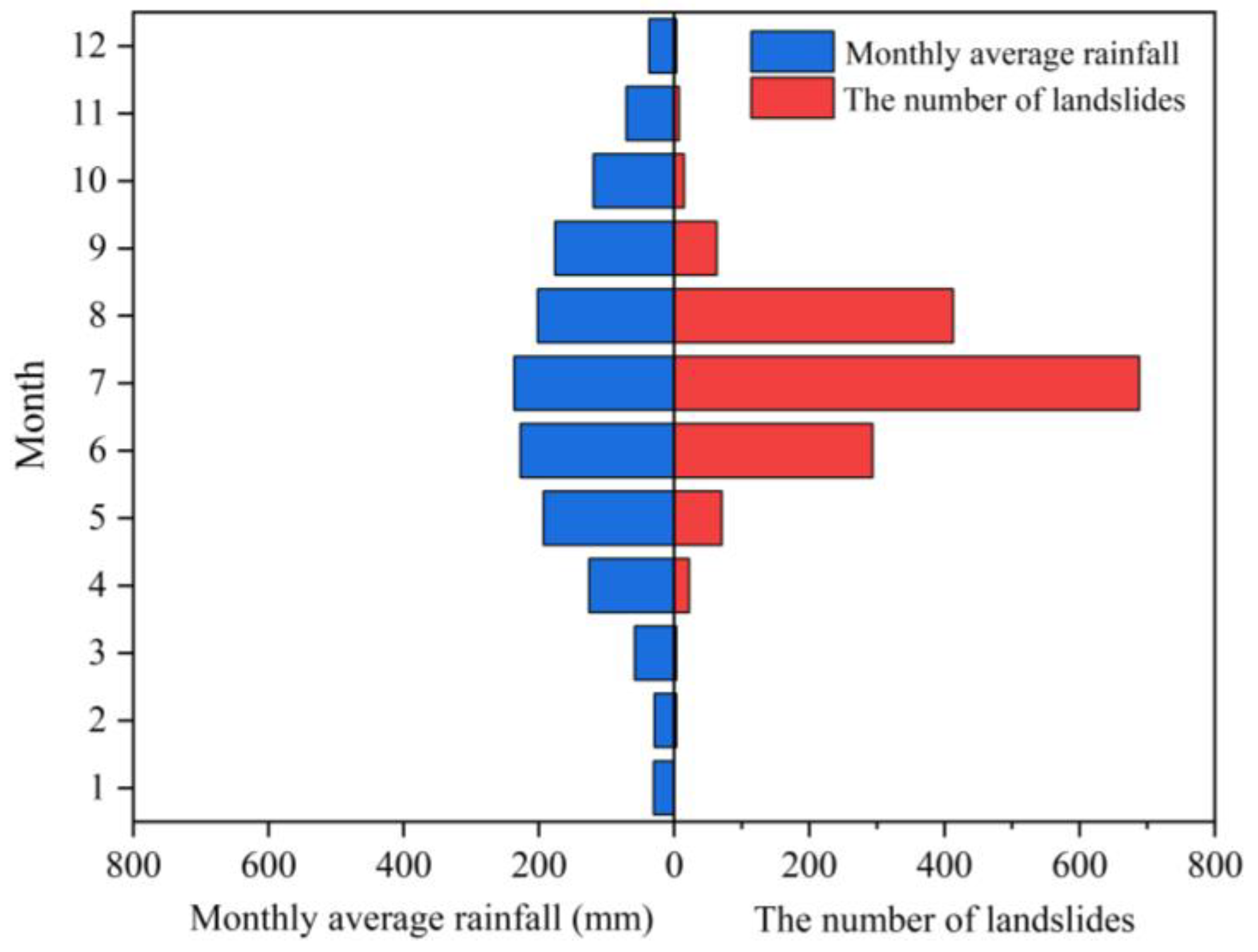
1. Introduction
2. Numerical Methodology
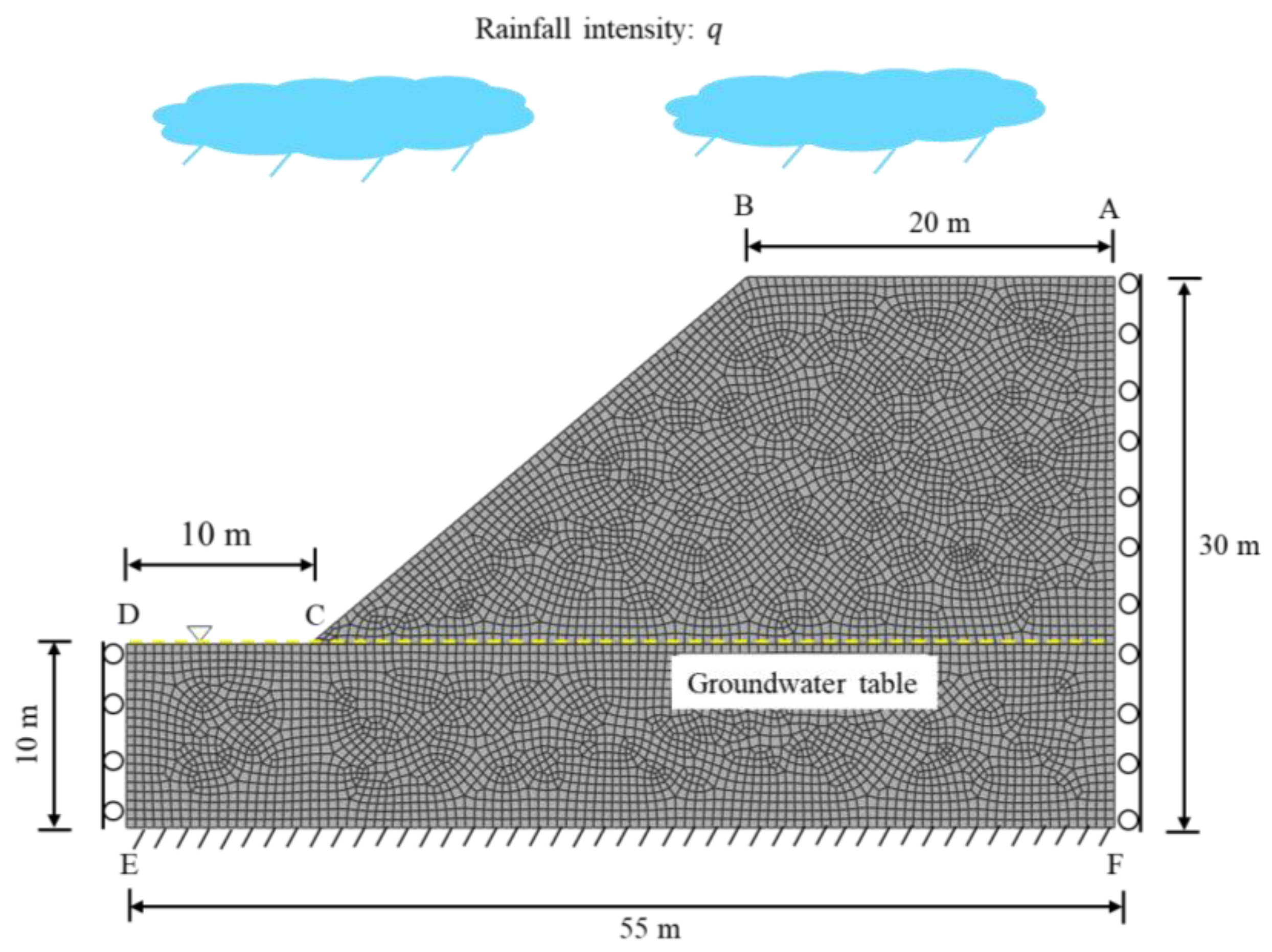
2.1. Geometry and Boundary Conditions
2.2. Analysis Step
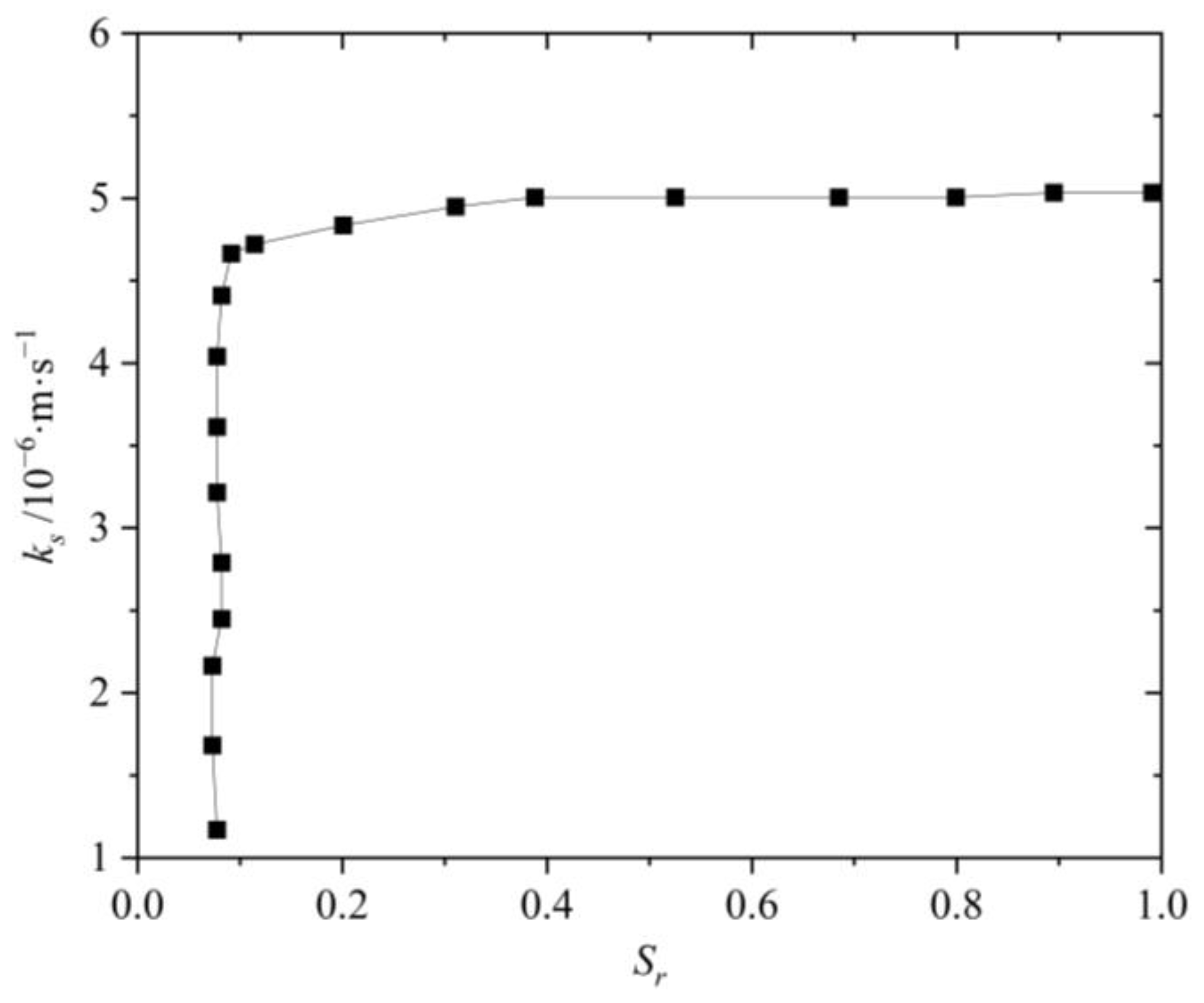
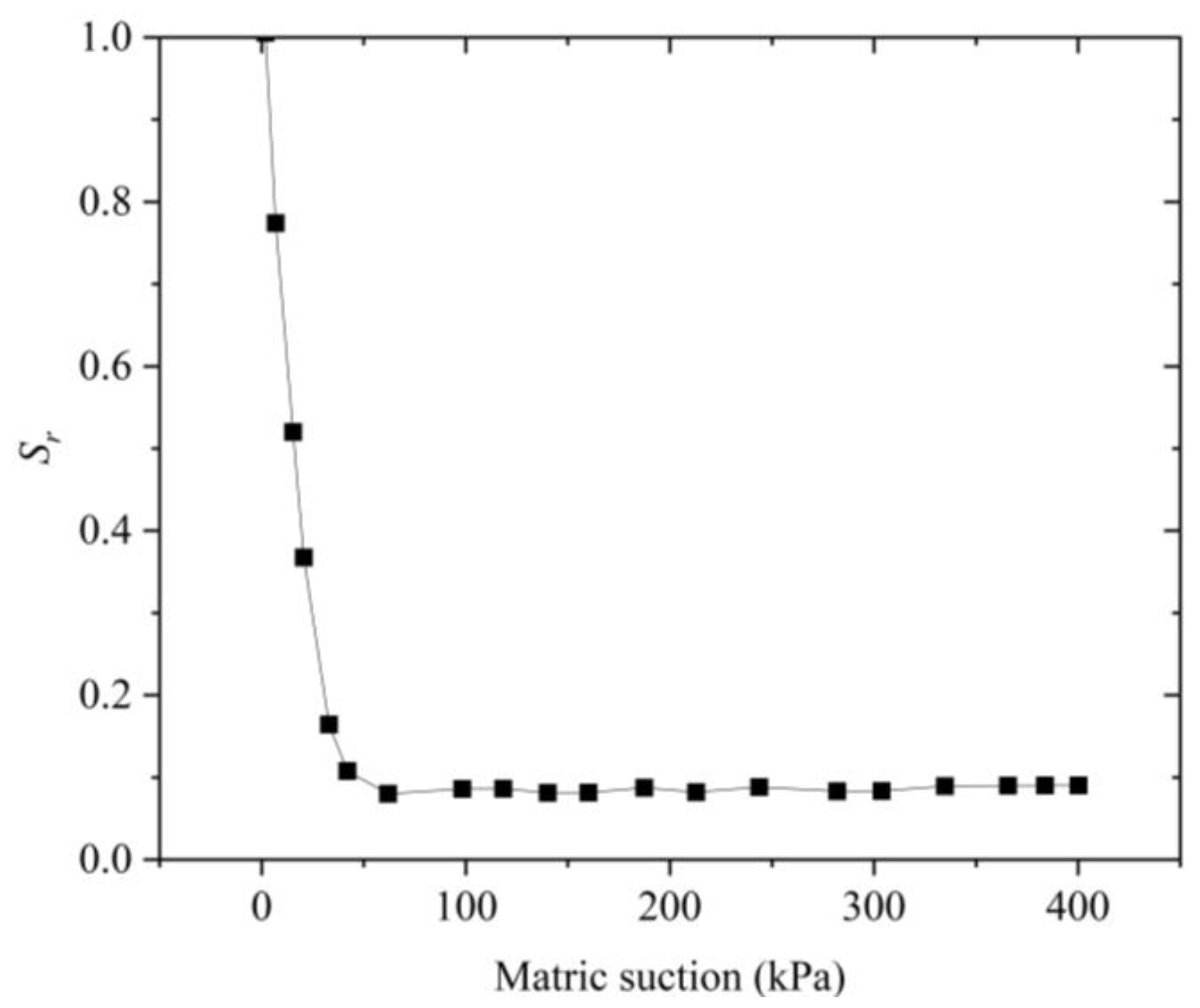
2.3. Model Parameters
2.4. Simulation Scheme
3. Results and Discussion
3.1. Analysis of Slope Stability Under Rainfall
- (1)
- Define the field variable, typically the strength reduction factor (SRF).
- (2)
- Specify the material properties that change with the field variables.
- (3)
- Establish the boundary conditions, and achieve numerical equilibrium.
- (4)
- Adjust and increase the field variable (i.e., SRF) until the numerical calculation fails to converge.
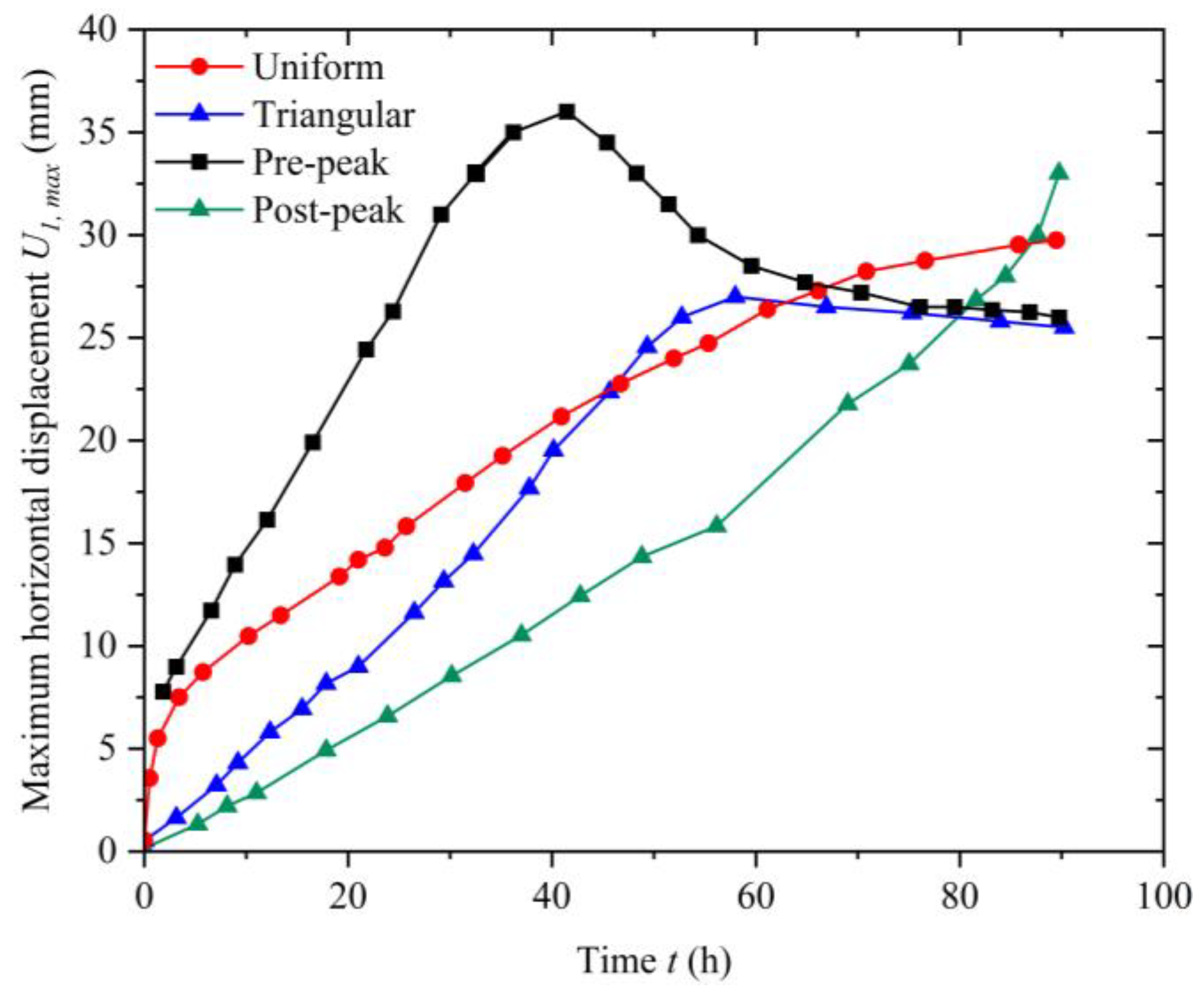
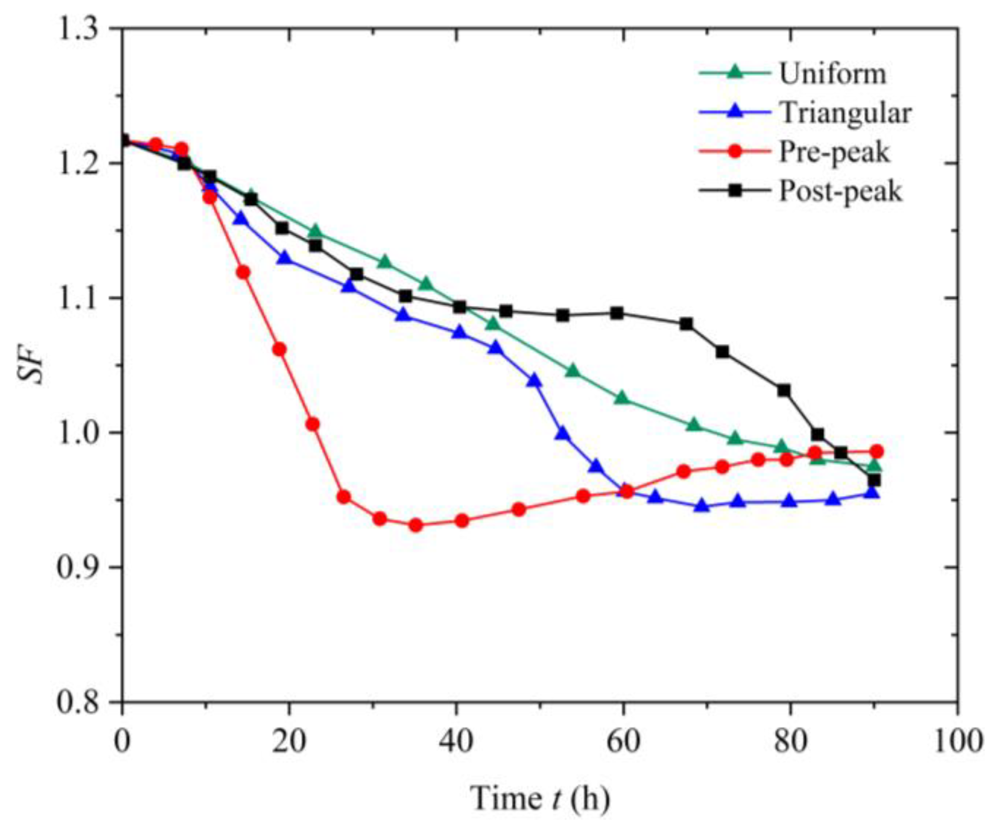
3.2. The Impact of Rainfall Patterns on Slope Instability and Failure
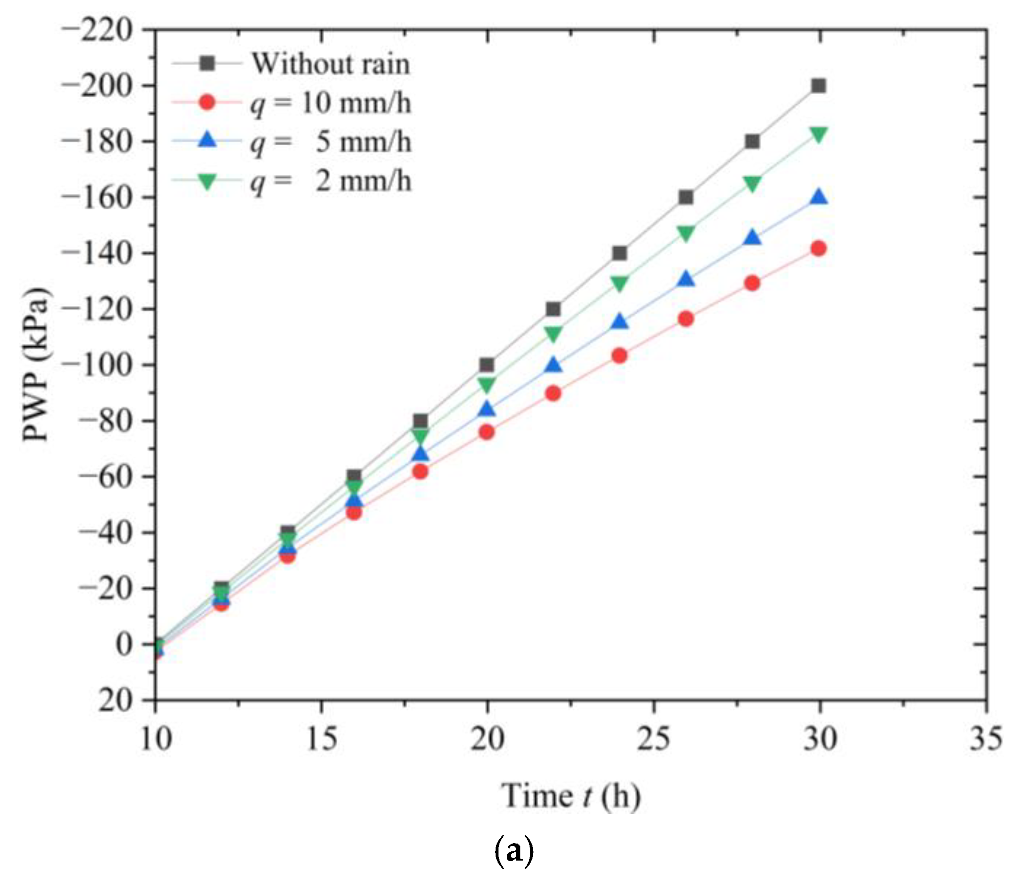
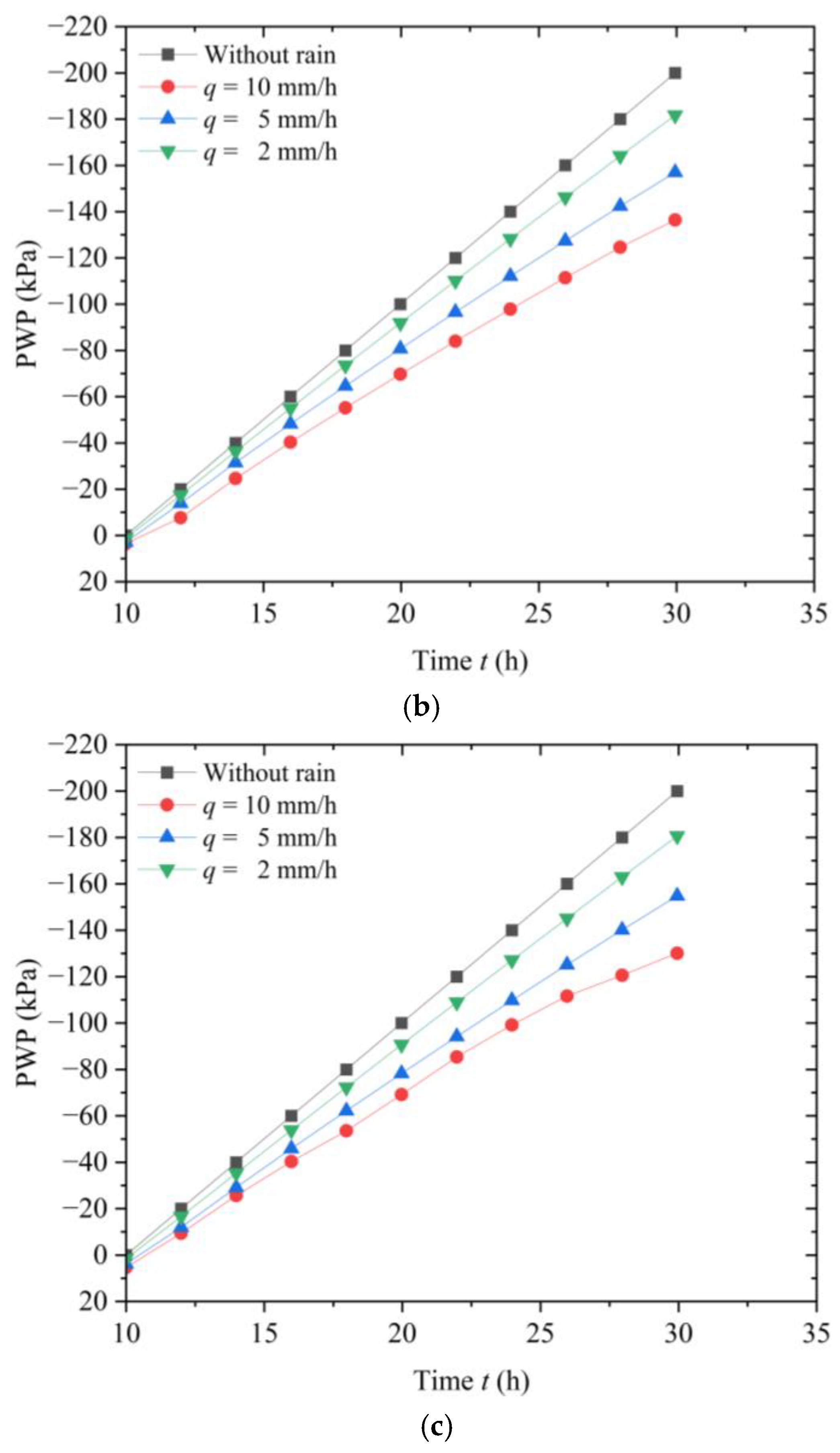
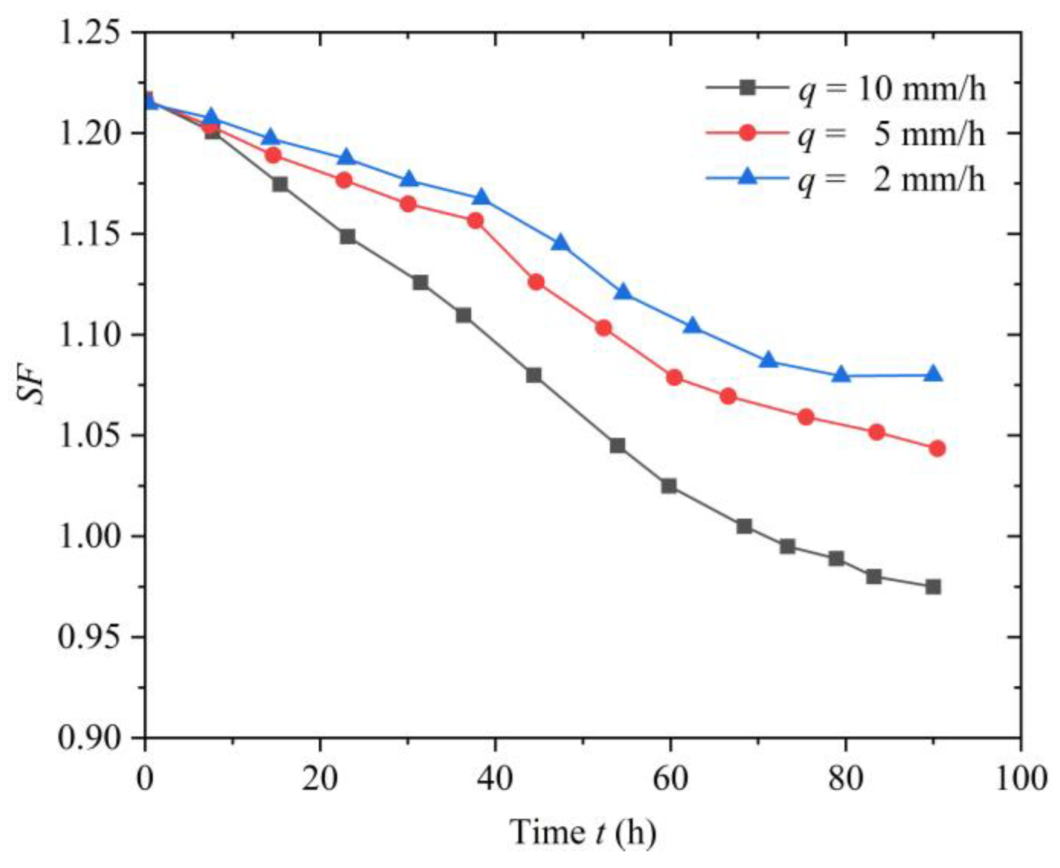
3.3. The Impact of Rainfall Intensity on Slope Instability and Failure
4. Conclusions
- (1)
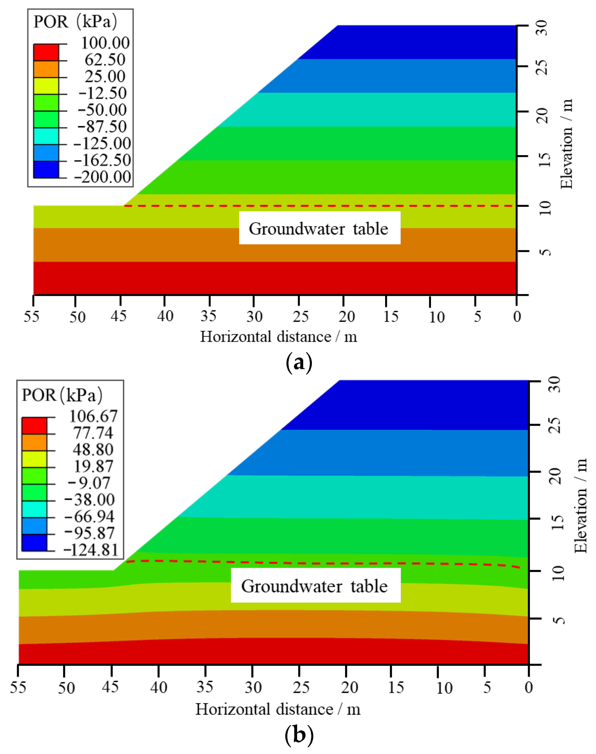
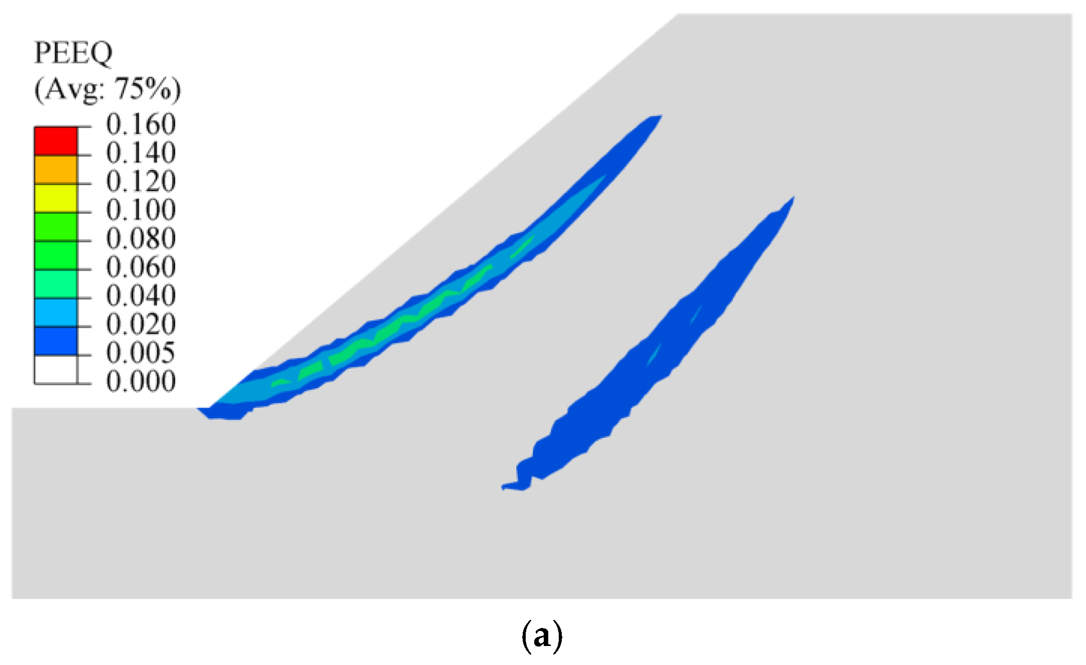
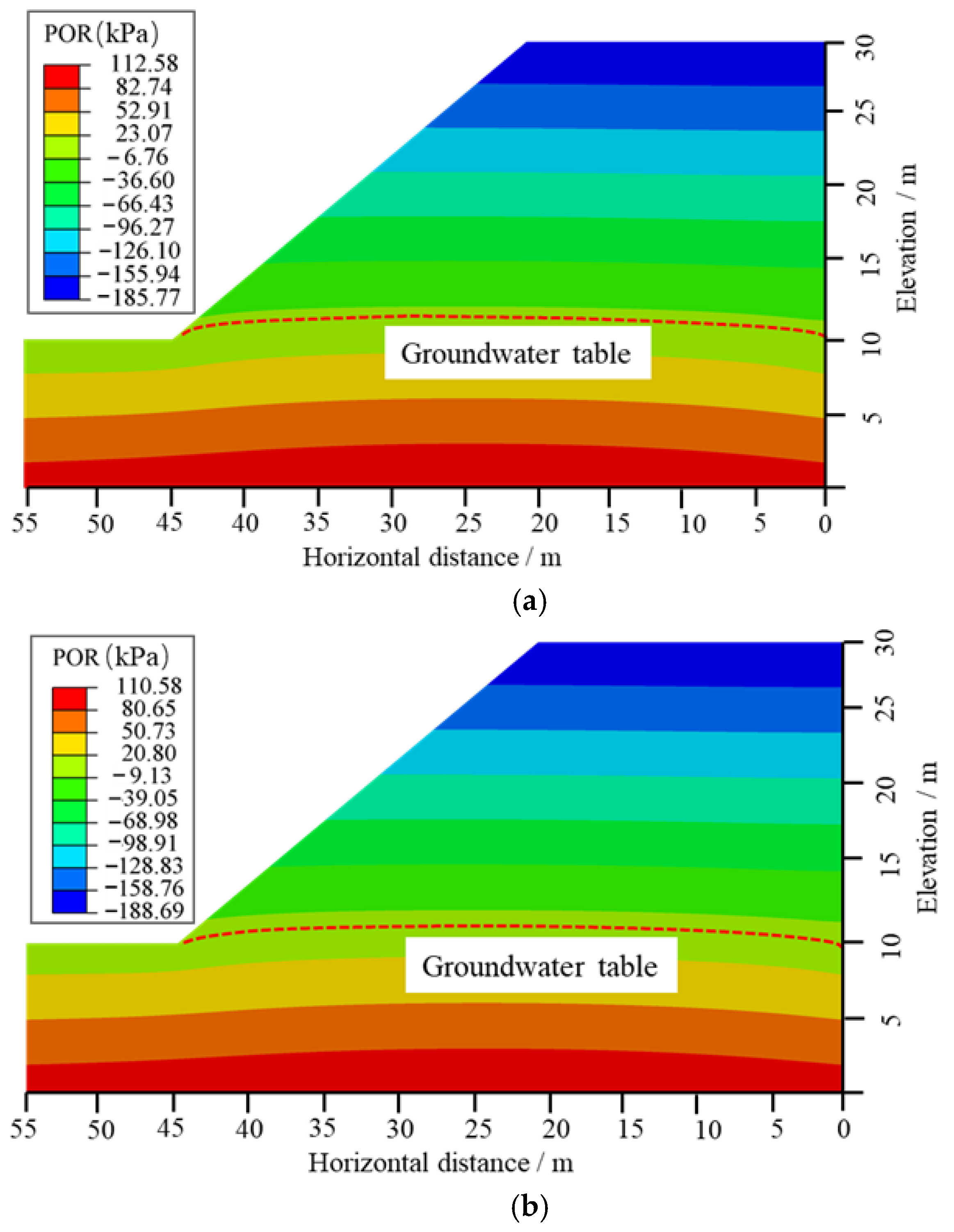
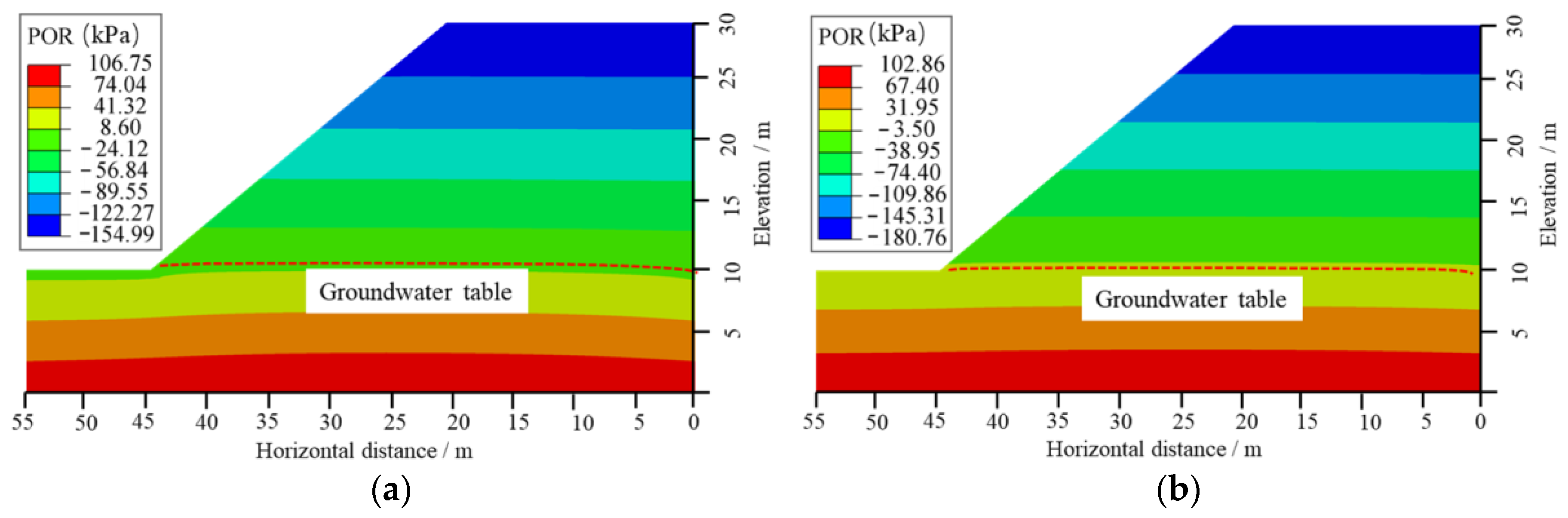
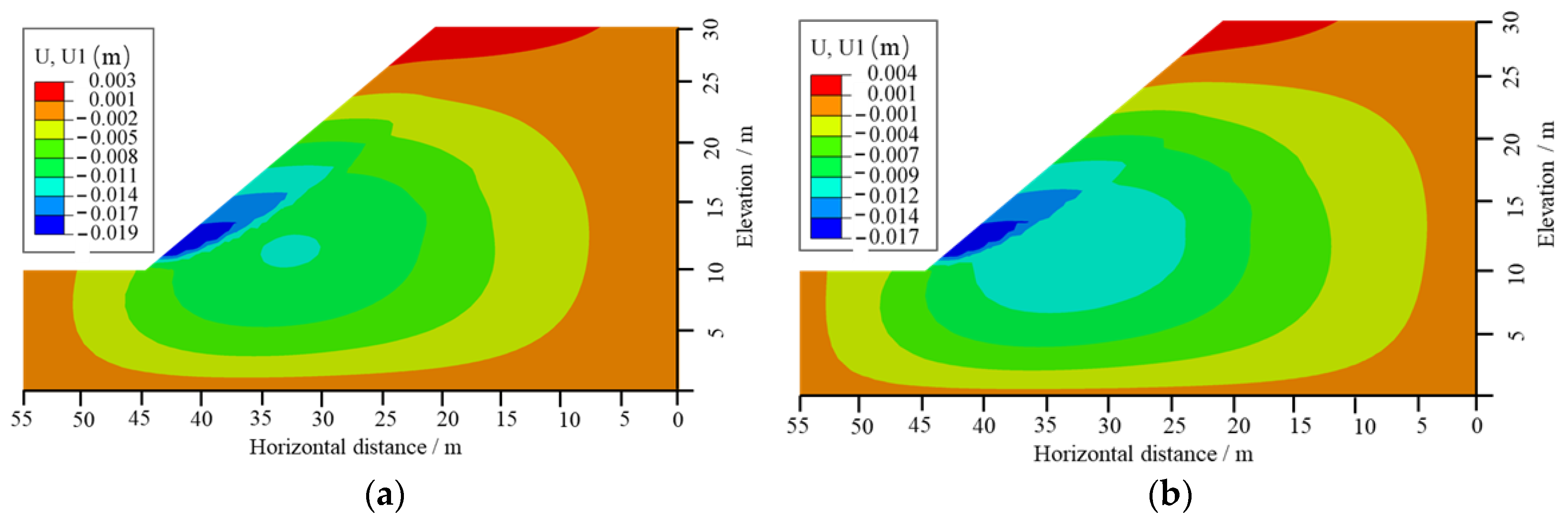
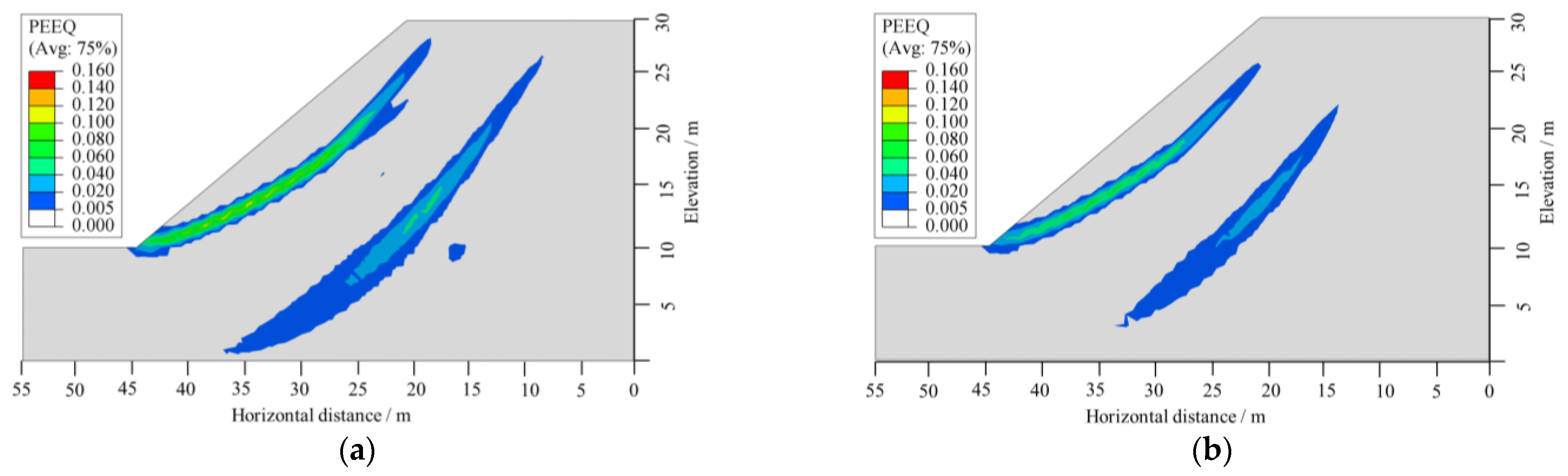
- Heavy rainfall can cause a temporary increase in negative PWP in the original unsaturated zone of the slope, leading to a closed phenomenon where the PWP isohyets extend from the slope crest to the interior. This process also elevates the free water surface. Meanwhile, under the infiltration of heavy rainfall, a through-going slip surface forming from the slope toe to the crest may develop within the slope, which is likely to trigger slope instability and sliding.
- (2)
- The influence of heavy rainfall patterns on the spatio-temporal evolution of slope PWP, displacement and SF is remarkably significant. The dynamic evolution of PWP is closely related to the rainfall intensity at various times, showing a direct proportional relationship. Moreover, for the same time point, rainfall patterns with higher intensities exhibit more pronounced deformation responses, particularly at the toe of the slope, where the horizontal deformation response of the soil and rock is most evident. With a constant total rainfall amount, the pre-peak rainfall pattern resulted in the greatest decrease in the SF of the slope and the earliest occurrence of failure. This indicates that the pre-peak rainfall pattern is most detrimental to slope stability. Therefore, monitoring and preventive measures should be enhanced for slopes under pre-peak rainfall pattern conditions.
- (3)
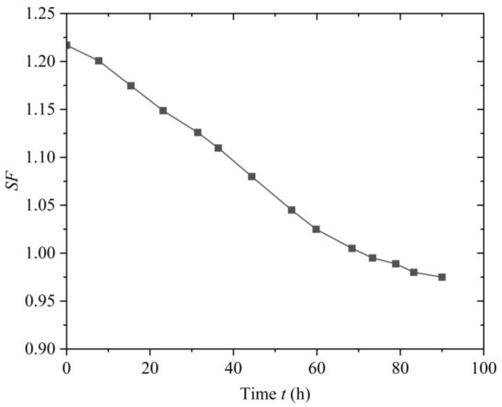
- For a uniform rainfall pattern, when the rainfall duration is the same, a higher rainfall intensity results in more water infiltrating into the slope. This leads to greater changes in PWP and maximum displacement, making the slope more susceptible to instability and failure. As the rainfall intensity increases, the reduction in the SF of the slope becomes more significant, and the time required for slope failure decreases. Therefore, in practical engineering, it is essential to enhance the forecasting of heavy rainfall and strengthen the monitoring and reinforcement of at-risk slopes.
Author Contributions
Funding
Data Availability Statement
Conflicts of Interest
References
- Liu, Y.; Cheng, P.; Liu, E.; Hu, J.; Cheng, Y.; Su, L. Seismic response and dynamic failure mode of a class of bedding rock slope subjected to freeze–thaw cycles. Rock Mech. Rock Eng. 2025, 58, 3289–3307. [Google Scholar] [CrossRef]
- Chen, R.H.; Chen, H.P.; Chen, K.S.; Zhung, H.B. Simulation of a slope failure induced by rainfall infiltration. Environ. Geol. 2009, 58, 943–952. [Google Scholar] [CrossRef]
- Rosly, M.H.; Mohamad, H.M.; Bolong, N.; Harith, N.S.H. An overview: Relationship of geological condition and rainfall with landslide events at East Malaysia. Trends Sci. 2022, 19, 3464. [Google Scholar] [CrossRef]
- Ijaz, N.; Ye, W.; Rehman, Z.; Dai, F.; Ijaz, Z. Numerical study on stability of lignosulphonate-based stabilized surficial layer of unsaturated expansive soil slope considering hydro-mechanical effect. Transp. Geotech. 2022, 32, 100697. [Google Scholar] [CrossRef]
- Qi, S.; Vanapalli, S.K. Hydro-mechanical coupling effect on surficial layer stability of unsaturated expansive soil slopes. Comput. Geotech. 2015, 70, 68–82. [Google Scholar] [CrossRef]
- Yang, K.H.; Uzuoka, R.; Lin, G.L.; Nakai, Y. Coupled hydro-mechanical analysis of two unstable unsaturated slopes subject to rainfall infiltration. Eng. Geol. 2017, 216, 13–30. [Google Scholar] [CrossRef]
- Ran, Q.; Wang, F.; Gao, J. Modelling effects of rainfall patterns on runoff generation and soil erosion processes on slopes. Water 2019, 11, 2221. [Google Scholar] [CrossRef]
- Tian, D.F.; Zheng, H.; Liu, D.F. A 2D integrated FEM model for surface water–groundwater flow of slopes under rainfall condition. Landslides 2017, 14, 577–593. [Google Scholar] [CrossRef]
- Zhang, J.; Hu, F.; Zhang, Q.; Wang, J.; Deng, W.; Zhang, L.; Shao, X. Evaluation of the Effects of Rainfall Infiltration Boundaries on the Stability of Unsaturated Soil Slopes Using the Particle Flow Code. Water 2024, 16, 3704. [Google Scholar] [CrossRef]
- Luo, S.; Huang, D.; Peng, J.; Aierken, A.; Li, Z.; Kuang, X.B.; Tomás, R. Performance and application of a novel drainage anti-slide pile on accumulation landslide with a chair-like deposit-bedrock interface in the Three Gorges Reservoir area, China. Comput. Geotech. 2023, 155, 105199. [Google Scholar] [CrossRef]
- Sun, Y.; Yang, K.; Hu, R.; Wang, G.; Lv, J. Model test and numerical simulation of slope instability process induced by rainfall. Water 2022, 14, 3997. [Google Scholar] [CrossRef]
- Kafle, L.; Xu, W.; Zeng, S.; Nagel, T. A numerical investigation of slope stability influenced by the combined effects of reservoir water level fluctuations and precipitation: A case study of the Bianjiazhai landslide in China. Eng. Geol. 2022, 297, 106508. [Google Scholar] [CrossRef]
- Sun, P.; Wang, H.; Wang, G.; Li, R.; Zhang, Z.; Huo, X. Field model experiments and numerical analysis of rainfall-induced shallow loess landslides. Eng. Geol. 2021, 295, 106411. [Google Scholar] [CrossRef]
- Reid, M.E.; Lahusen, R.G. Real-time monitoring of active landslides along highway 50, El Dorado County. Calif. Geol. 1998, 51, 17–20. [Google Scholar]
- Rahardjo, H.; Nio, A.S.; Leong, E.C.; Song, N.Y. Effects of groundwater table position and soil properties on stability of slope during rainfall. J. Geotech. Geoenviron. Eng. 2010, 136, 1555–1564. [Google Scholar] [CrossRef]
- Regmi r k jung k Nakagawa, H.; Kang, J. Study on mechanism of retrogressive slope failure using artificial rainfall. Catena 2014, 122, 27–41. [Google Scholar] [CrossRef]
- Collins, B.D.; Znidarcic, D. Stability analyses of rainfall induced landslides. J. Geotech. Geoenviron. Eng. 2004, 130, 362–372. [Google Scholar] [CrossRef]
- Tohari, A.; Nishigaki, M.; Komatsu, M. Laboratory rainfall-induced slope failure with moisture content measurement. J. Geotech. Geoenviron. Eng. 2007, 133, 575–587. [Google Scholar] [CrossRef]
- Xie, J.; Uchimura, T.; Wang, G.; Selvarajah, H.; Maqsood, Z.; Shen, Q.; Mei, G.; Qiao, S. Predicting the sliding behavior of rotational landslides based on the tilting measurement of the slope surface. Eng. Geol. 2020, 269, 105554. [Google Scholar] [CrossRef]
- Xie, J.; Uchimura, T.; Wang, G.; Shen, Q.; Maqsood, Z.; Xie, C.; Liu, J.; Lei, W.; Tao, S.; Chen, P.; et al. A new prediction method for the occurrence of landslides based on the time history of tilting of the slope surface. Landslides 2020, 17, 301–312. [Google Scholar] [CrossRef]
- Xie, J.; Uchimura, T.; Huang, C.; Maqsood, Z.; Tian, J. Experimental study on the relationship between the velocity of surface movements and tilting rate in pre-failure stage of rainfall-induced landslides. Sensors 2021, 21, 5988. [Google Scholar] [CrossRef]
- Yang, H.Q.; Shi, C.; Zhang, L. Ensemble learning of soil–water characteristic curve for unsaturated seepage using physics-informed neural networks. Soils Found. 2025, 65, 101556. [Google Scholar] [CrossRef]
- Lan, P.; Su, J.; Zhu, S.; Huang, J.; Zhang, S. Reconstructing unsaturated infiltration behavior with sparse data via physics-informed deep learning. Comput. Geotech. 2024, 168, 106162. [Google Scholar] [CrossRef]
- Gu, X.; Wang, L.; Ou, Q.; Zhang, W. Efficient stochastic analysis of unsaturated slopes subjected to various rainfall intensities and patterns. Geosci. Front. 2023, 14, 101490. [Google Scholar] [CrossRef]
- Cho, S.E.; Lee, S.R. Instability of unsaturated soil slopes due to infiltration. Comput. Geotech. 2001, 28, 185–208. [Google Scholar] [CrossRef]
- Cheng, P.; Liu, Y.; Hu, J.; Fang, K.; Hu, Y. Experimental study on dynamic response and failure mode of bedding rock slope with cracks under earthquake. Bull. Eng. Geol. Environ. 2025, 84, 81. [Google Scholar] [CrossRef]
- Li, B.; Gao, Y.; Yin, Y.; Wan, J.; He, K.; Wu, W.; Zhang, H. Rainstorm-induced large-scale landslides in Northeastern Chongqing, China, August 31 to September 2, 2014. Bull. Eng. Geol. Environ. 2022, 81, 271. [Google Scholar] [CrossRef]
- Yang, G.; Wu, Z.; Zhang, L.; Yang, G.; Wu, Z.; Zhang, L.; Hou, J.; Tong, S.; Liu, F.; Zheng, Y. A Study on the Deformation Mechanism of a Landslide Reinforced with an Anti-Slip Pile Under the Effect of Reservoir Water Level Decline. Water 2025, 17, 1390. [Google Scholar] [CrossRef]


| Soil Parameters | Values |
|---|---|
| Effective cohesion (kPa) | 15 |
| Effective friction angle (°) | 30 |
| Young’s modulus E (MPa) | 100 |
| Unit weight (kN/m3) | 19.5 |
| Poisson’s ratio | 0.3 |
| Saturated hydraulic conductivity ks (m/s) | 2.8 × 10⁻⁶ |
| Scheme | Rainfall Intensity q (mm/h) | Rainfall Duration t (h) | Rainfall Patterns | Influencing Factors |
|---|---|---|---|---|
| Scheme 1 | 10 | 90 | Uniform | Rainfall |
| Scheme 2 | 10 | 90 | Uniform, triangular, pre-peak, post-peak | Rainfall patterns |
| Scheme 3 | 10, 5, 2 | 90 | Uniform | Rainfall intensity |
Disclaimer/Publisher’s Note: The statements, opinions and data contained in all publications are solely those of the individual author(s) and contributor(s) and not of MDPI and/or the editor(s). MDPI and/or the editor(s) disclaim responsibility for any injury to people or property resulting from any ideas, methods, instructions or products referred to in the content. |
© 2025 by the authors. Licensee MDPI, Basel, Switzerland. This article is an open access article distributed under the terms and conditions of the Creative Commons Attribution (CC BY) license (https://creativecommons.org/licenses/by/4.0/).
Share and Cite
Wu, Z.; Yang, G.; Li, W.; Chen, X.; Liu, F.; Zheng, Y. Numerical Simulation Study of Rainfall-Induced Saturated–Unsaturated Landslide Instability and Failure. Water 2025, 17, 2229. https://doi.org/10.3390/w17152229
Wu Z, Yang G, Li W, Chen X, Liu F, Zheng Y. Numerical Simulation Study of Rainfall-Induced Saturated–Unsaturated Landslide Instability and Failure. Water. 2025; 17(15):2229. https://doi.org/10.3390/w17152229
Chicago/Turabian StyleWu, Zhuolin, Gang Yang, Wen Li, Xiangling Chen, Fei Liu, and Yong Zheng. 2025. "Numerical Simulation Study of Rainfall-Induced Saturated–Unsaturated Landslide Instability and Failure" Water 17, no. 15: 2229. https://doi.org/10.3390/w17152229
APA StyleWu, Z., Yang, G., Li, W., Chen, X., Liu, F., & Zheng, Y. (2025). Numerical Simulation Study of Rainfall-Induced Saturated–Unsaturated Landslide Instability and Failure. Water, 17(15), 2229. https://doi.org/10.3390/w17152229