
Quantitative Assessment of Flood Risk Through Multi Parameter Morphometric Analysis and GeoAI: A GIS-Based Study of Wadi Ranuna Basin in Saudi Arabia


Abstract
1. Introduction
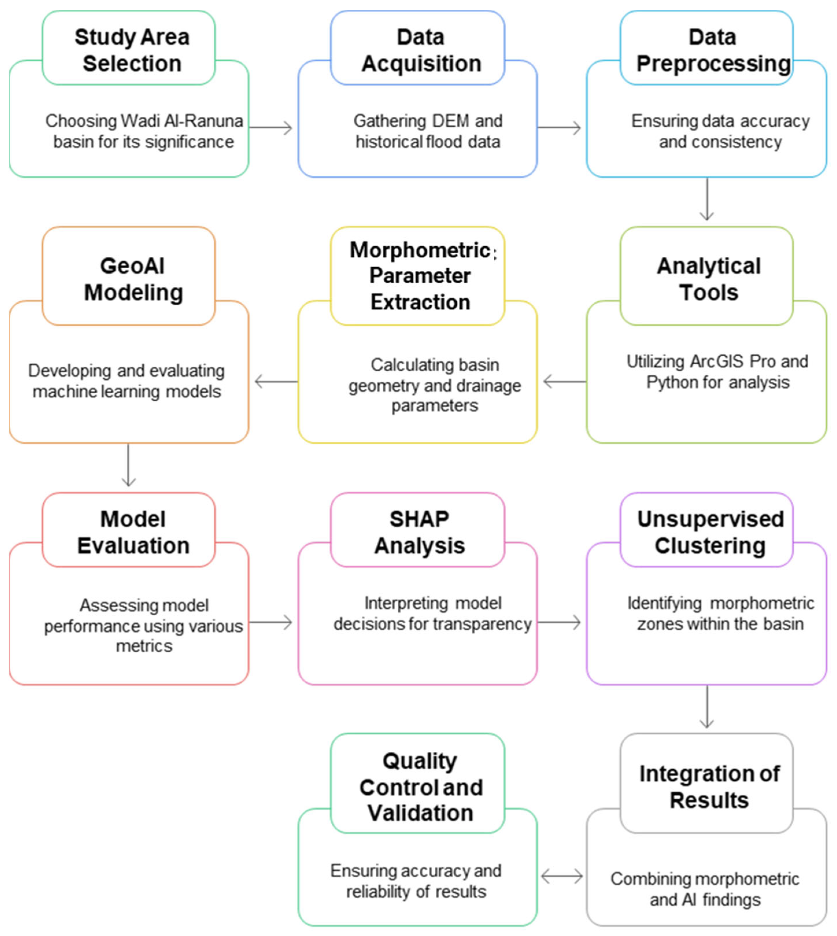
2. Materials and Methods
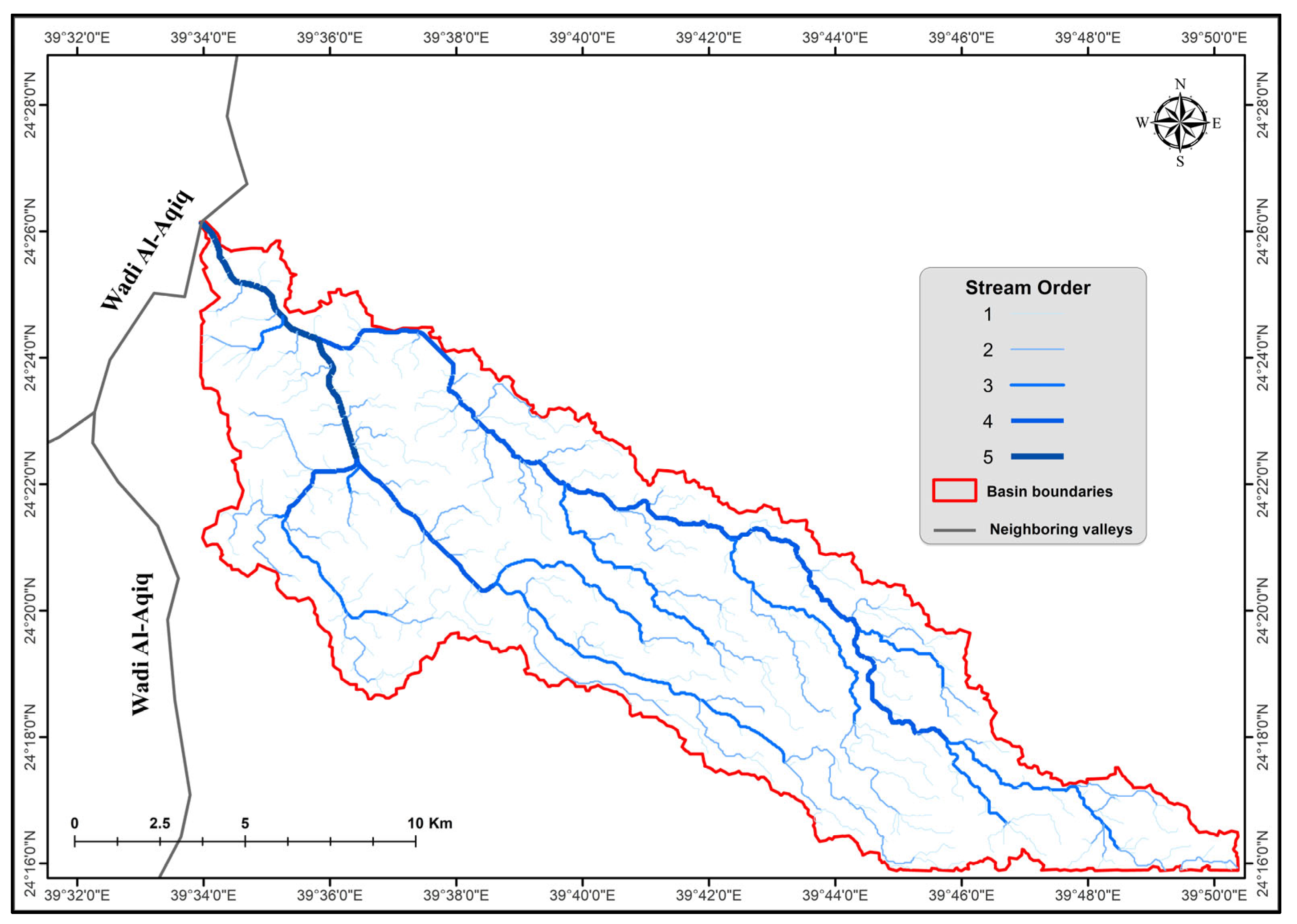
2.1. Study Area
2.2. Data Sources and Acquisition
2.3. Analytical Tools and Software
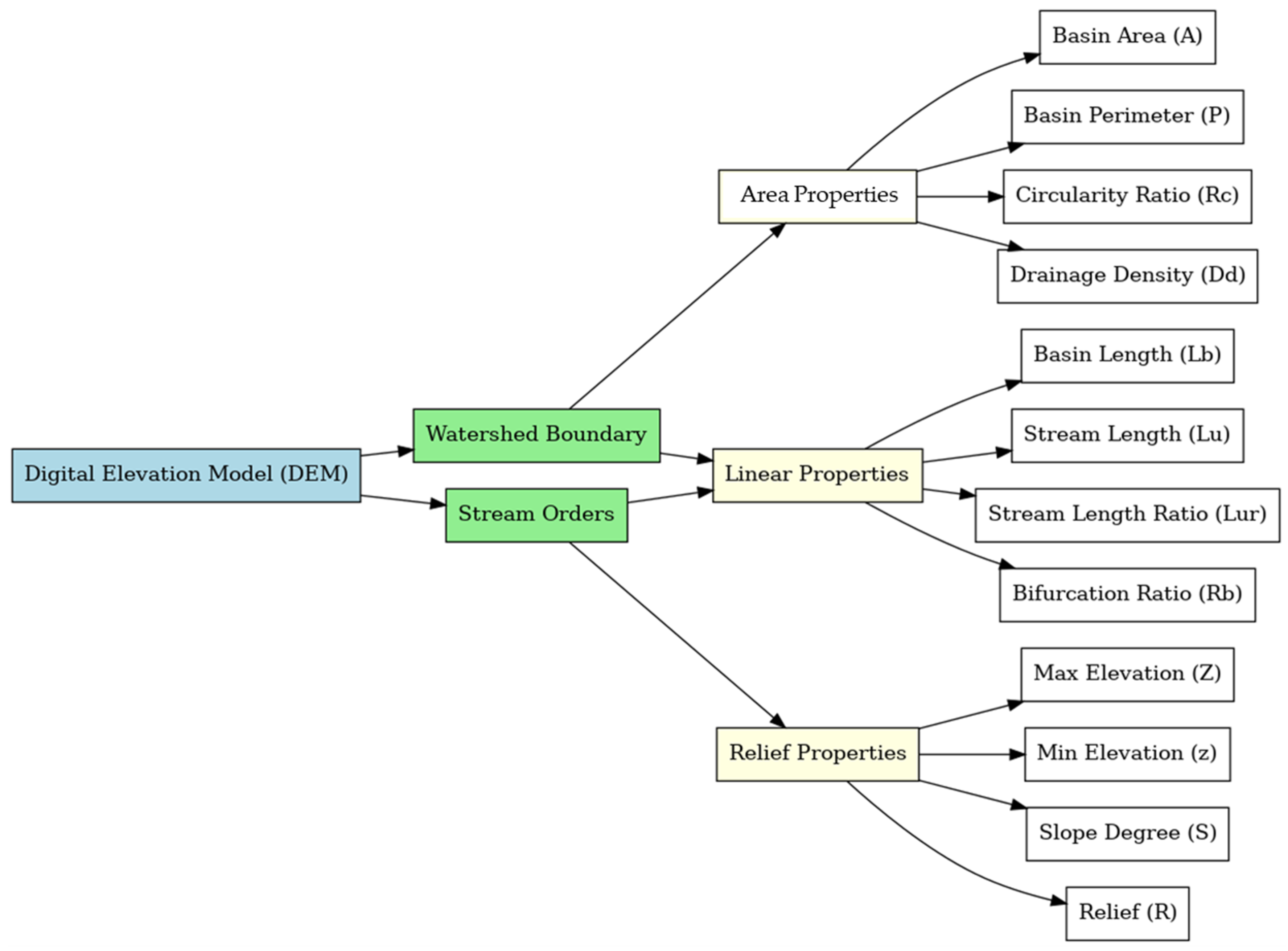
2.4. Morphometric Parameters
2.4.1. Basin Geometry Parameters
2.4.2. Topographic Parameters
2.4.3. Drainage Network Parameters
2.4.4. Texture Parameters
2.5. GeoAI Modeling Framework
2.5.1. Dataset Preparation for Machine Learning
2.5.2. Model Selection and Optimization
2.5.3. Model Evaluation Metrics
2.5.4. SHAP Analysis for Model Interpretability
2.6. Unsupervised Clustering for Morphometric Zone Identification
2.6.1. Feature Preprocessing for Clustering
2.6.2. K-Means Clustering
2.6.3. DBSCAN Clustering
2.6.4. Cluster Characterization and Validation
2.7. Integration of Morphometric Analysis and Machine Learning Results
2.8. Quality Control and Validation
3. Results
3.1. Morphological Characteristics
3.2. Topographical Features
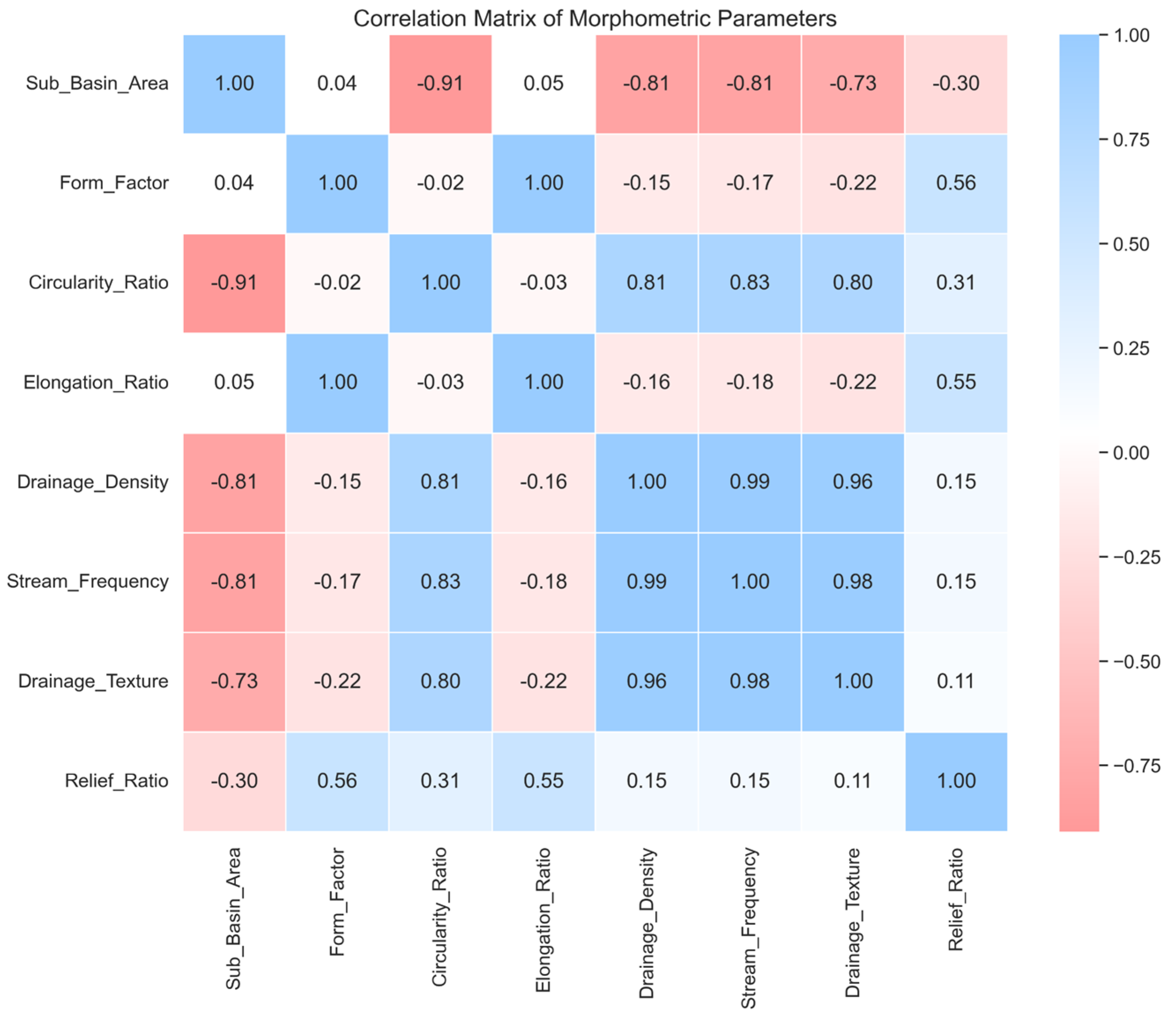
3.3. Drainage Network Analysis
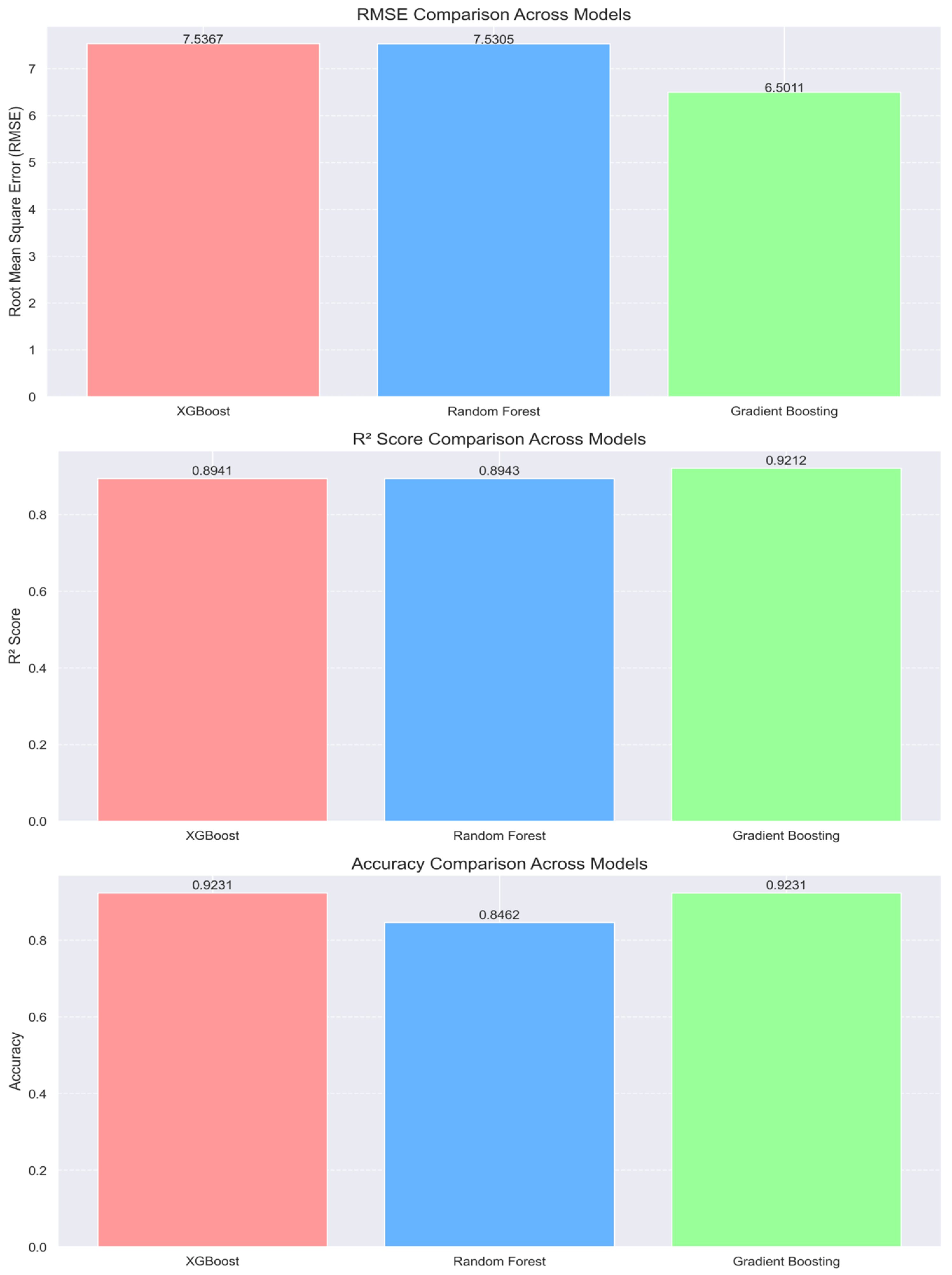
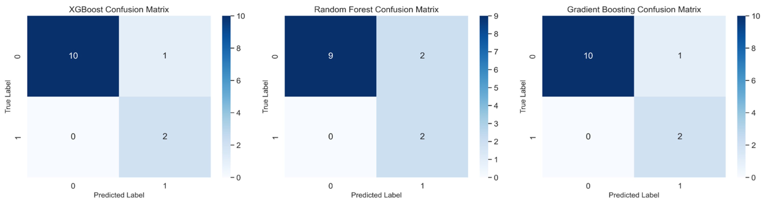
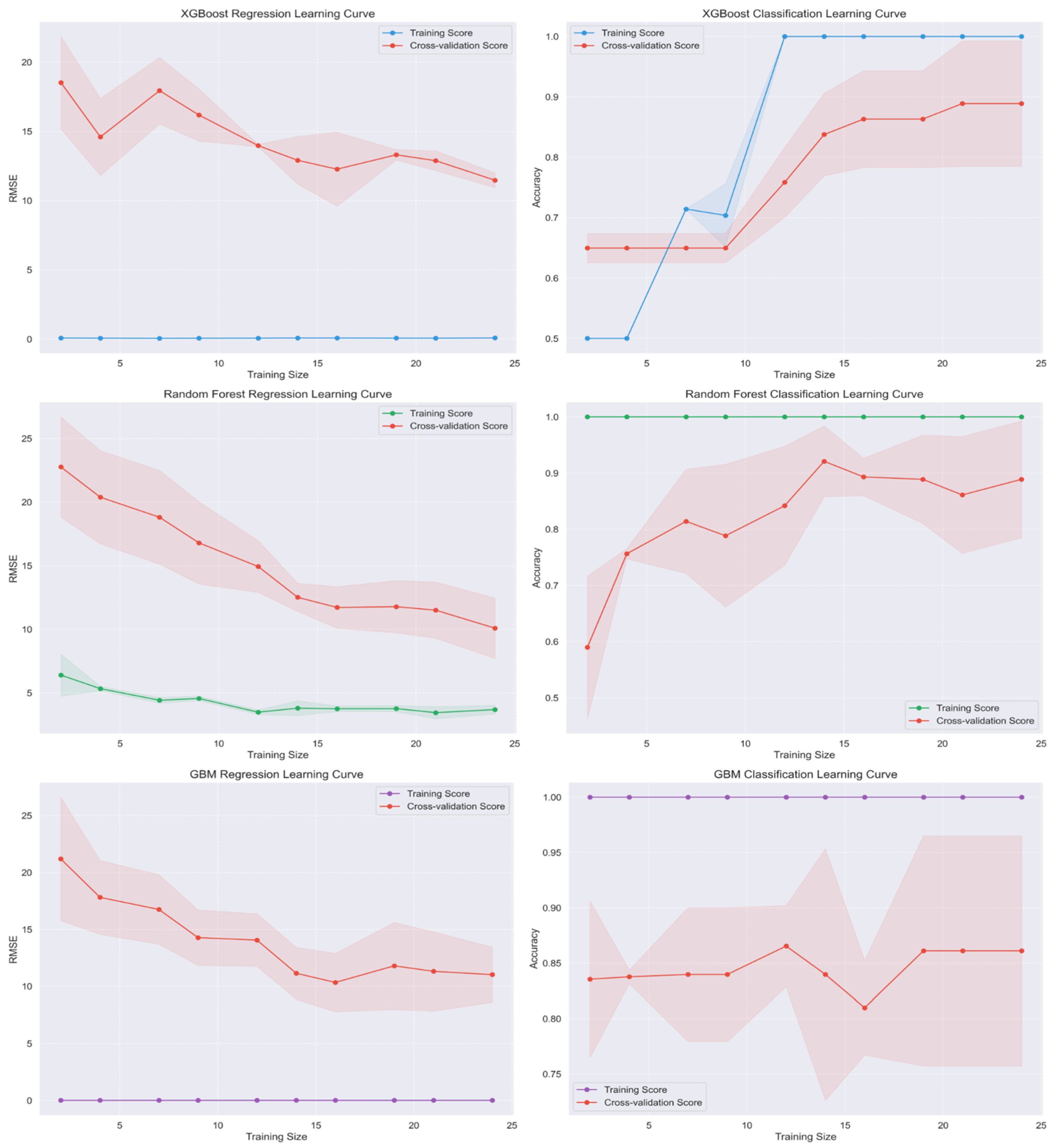
3.4. GeoAI Model Performance and Validation
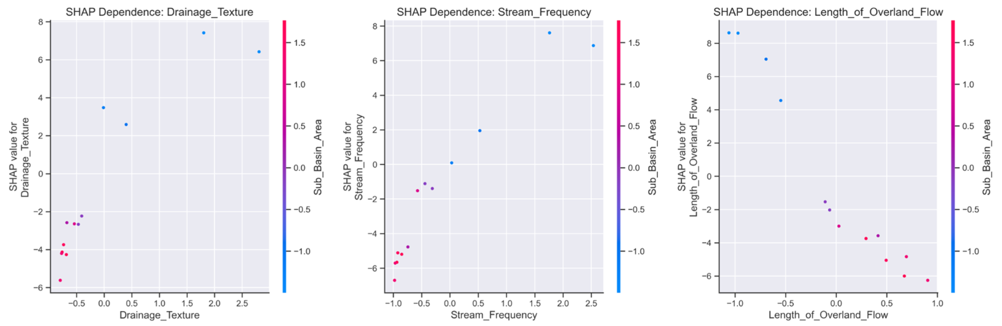
3.5. Model Explanation Using SHAP Values
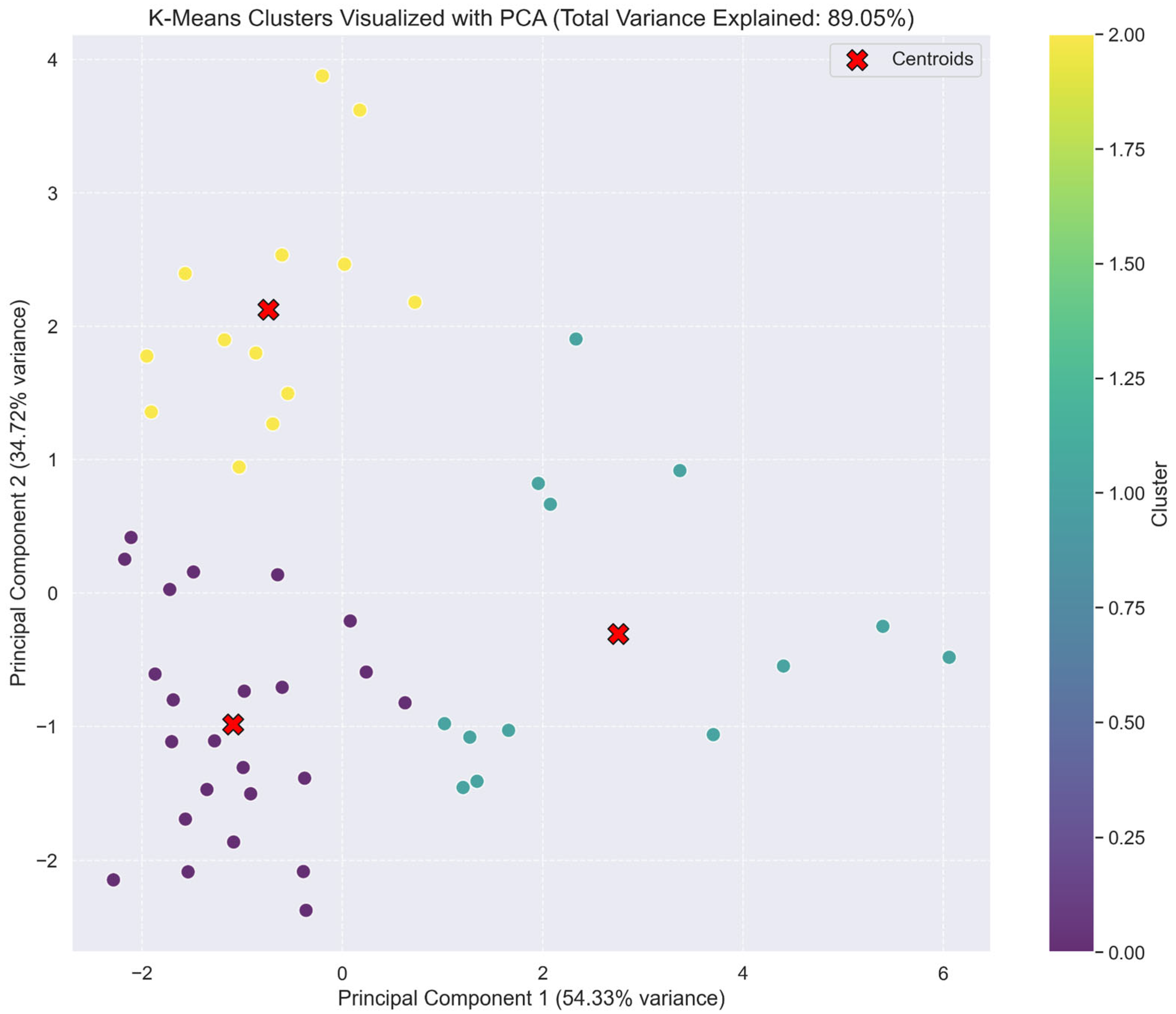
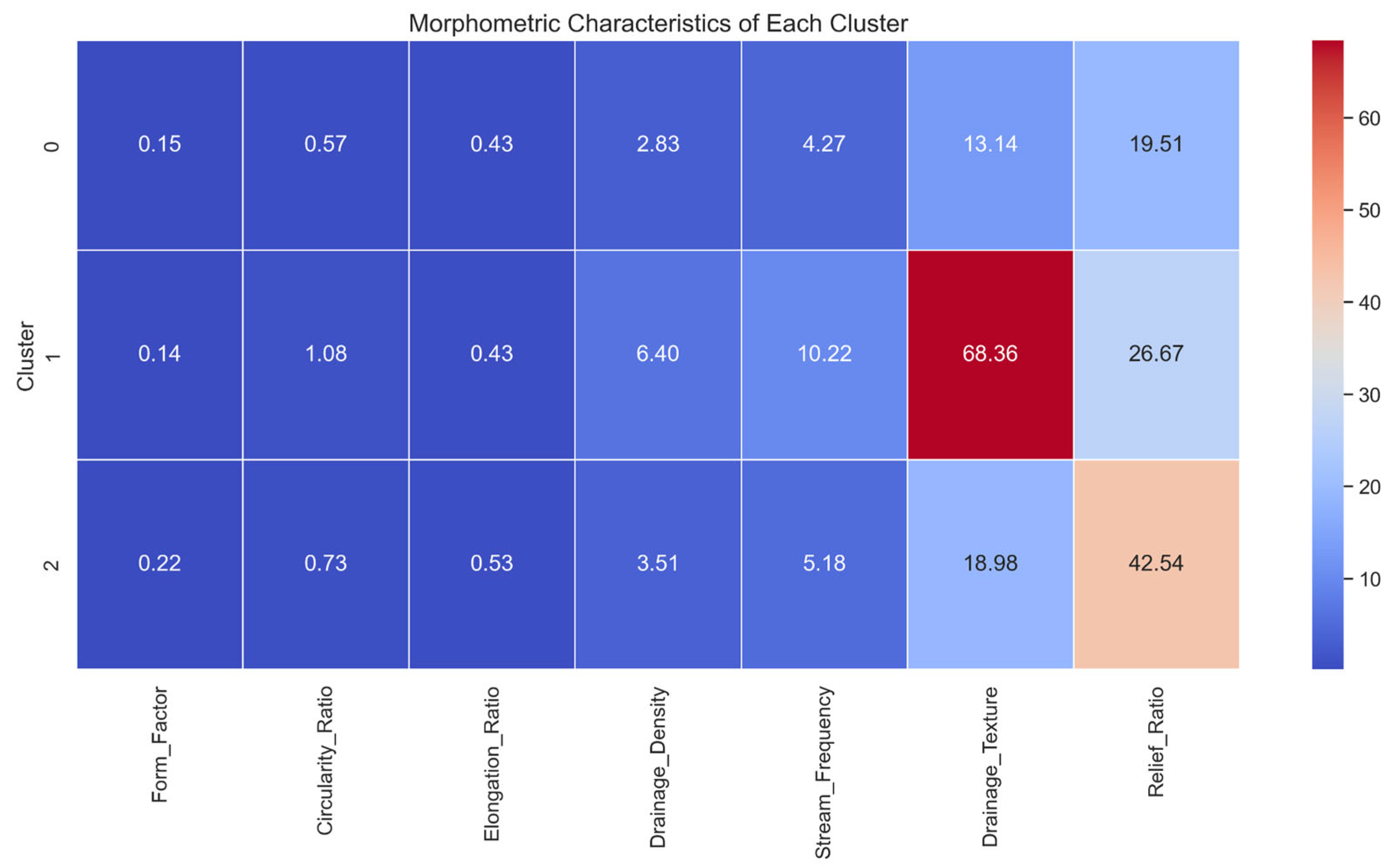
3.6. Morphometric Zone Identification via Clustering
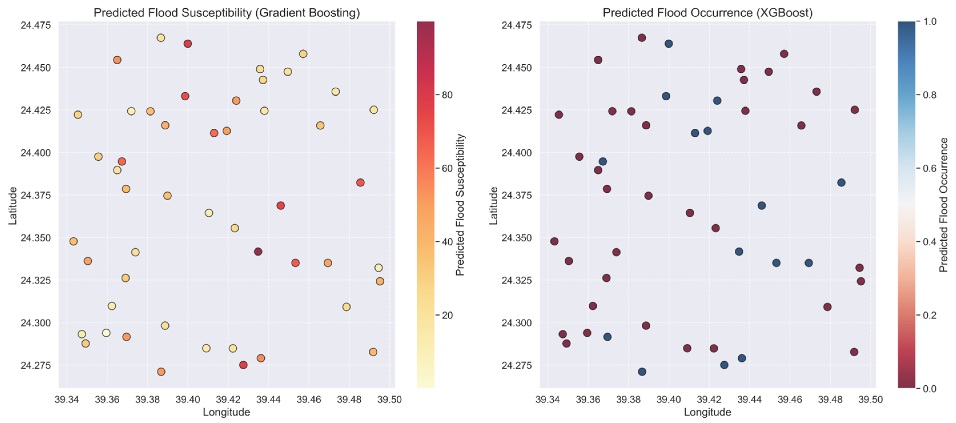
3.7. Spatial Distribution of Flood Susceptibility
3.8. Integration of Morphometric Indices and Machine Learning Results
4. Discussion
4.1. Basin Morphometry and Flood Response
4.2. Drainage Network Evolution and Efficiency
4.3. Topographic Controls on Hydrological Response
4.4. GeoAI Performance and Comparative Advantage
4.5. Flood Risk Zoning Through Integrated Clustering
4.6. Implications for Urban Development and Flood Management
4.7. Environmental Sustainability Considerations
4.8. Study Limitations and Future Research Directions
5. Conclusions
Author Contributions
Funding
Data Availability Statement
Acknowledgments
Conflicts of Interest
References
- Aneiba, O.I.A.; Farhan, Y.A. Applied Morphometric Analysis of Selected Basins in Jordan Using Remote Sensing and GIS. Ph.D. Thesis, The University of Jordan, Amman, Jordan, 2016. Unpublished. [Google Scholar]
- Al-Nashwan, A.A. Morphometric Characteristics of Sha’ib Tamrah Basin in As-Sulayel Governorate. Hadhramout Univ. J. Humanit. 2018, 15. Available online: https://hu.edu.ye/hu-publications/journals/index.php/hujh/article/view/400 (accessed on 7 July 2025).
- Al-Madinah Region Municipality. Hydrological Study Report for the Mitigation of Flash Flood Risks in Al-Madinah Valleys; Al-Madinah Region Municipality: Medina, Saudi Arabia, 2023. [Google Scholar]
- Al-Tuwaijri, H.A.; Al-Juaidi, F.H.; Al-Khuwaiqi, M.I. Wadi Al-Mashqar in Majmaah: Morphometric Study Using Digital Elevation Models. King Abdulaziz Univ. J. Arts Humanit. 2022, 28, 274–285. [Google Scholar]
- Bashir, B.; Alsalman, A. Flooding Hazard Vulnerability Assessment Using Remote Sensing Data and Geospatial Techniques: A Case Study from Mekkah Province, Saudi Arabia. Water 2024, 16, 2714. [Google Scholar] [CrossRef]
- Almulhim, A.I.; Al Kafy, A.; Ferdous, N.; Fattah, A.; Morshed, S.R. Harnessing urban analytics and machine learning for sustainable urban development: A multidimensional framework for modeling environmental impacts of urbanization in Saudi Arabia. J. Environ. Manag. 2024, 357, 120705. [Google Scholar] [CrossRef] [PubMed]
- Altuwaijri, H.A.; Al Kafy, A. Decoding atmospheric thermal exposure patterns with implications for environmental health and urban air quality over forty years in arid regions. Air Qual. Atmosphere Heal. 2025, 1–26. [Google Scholar] [CrossRef]
- Tarek Waly Center for Architecture and Heritage. Urban Centers Development Study in Al-Madinah Al-Munawwarah; Tarek Waly Center for Architecture and Heritage: Cairo, Egypt, 2006. [Google Scholar]
- Hajam, R.A.; Hamid, A.; Bhat, S. Application of Morphometric Analysis for Geo-Hydrological Studies Using Geo-Spatial Technology: A Case Study of Vishav Drainage Basin. Appl. Water Sci. 2013, 4, 1000157. [Google Scholar]
- Das, S.; Pardeshi, S. Morphometric Analysis of Vaitarna and Ulhas River Basins, Maharashtra, India, Using Geospatial Techniques. Appl. Water Sci. 2018, 8, 158. [Google Scholar] [CrossRef]
- Khudr, M. Geomorphological Hazards in Egypt, with a Focus on Flash Floods in the Nile Valley: A Study in Applied Geomorphology; Faculty of Arts, Ain Shams University: Cairo, Egypt, 1997. [Google Scholar]
- Alajji, A. Applying GIS to Build a Morphometric Database and Hydrological Implications in Wadi Yalmlam Basin. Master’s Thesis, Umm Al-Qura University, Mecca, Saudi Arabia, 2010. Unpublished. [Google Scholar]
- Horton, R.E. Erosional Development of Streams and Their Drainage Basins; Hydro-Physical Approach to Quantitative Morphology. Bull. Geol. Soc. Am. 1945, 56, 275–370. [Google Scholar] [CrossRef]
- Hasanuzzaman, M.; Islam, A.; Bera, B.; Shit, P.K. Flood Susceptibility Mapping Using Morphometric Parameters and GIS. In Spatial Modelling of Flood Risk and Flood Hazards. GIScience and Geo-Environmental Modelling; Pradhan, B., Shit, P.K., Bhunia, G.S., Adhikary, P.P., Pourghasemi, H.R., Eds.; Springer: Cham, Switzerland, 2022. [Google Scholar] [CrossRef]
- Khodaei, H.; Saleh, F.N.; Dalir, A.N.; Zarei, E. Future flood susceptibility mapping under climate and land use change. Sci. Rep. 2025, 15, 12394. [Google Scholar] [CrossRef] [PubMed]
- Pareta, K.; Pareta, U. Integrated Watershed Modeling and Characterization Using GIS and Remote Sensing Techniques. Indian J. Eng. 2012, 1, 81–91. [Google Scholar]
- Hajji, S.; Krimissa, S.; Abdelrahman, K.; Boudhar, A.; Elaloui, A.; Ismaili, M.; El Bouzekraoui, M.; Essbiti, M.C.; Kahal, A.Y.; Mondal, B.K.; et al. Enhancing flood prediction through remote sensing, machine learning, and Google Earth Engine. Front. Water 2025, 7, 1514047. [Google Scholar] [CrossRef]
- Ahmed, A.; Al Maliki, A.; Hashim, B.; Alshamsi, D.; Arman, H.; Gad, A. Flood susceptibility mapping utilizing the integration of geospatial and multivariate statistical analysis, Erbil area in Northern Iraq as a case study. Sci. Rep. 2023, 13, 11919. [Google Scholar] [CrossRef] [PubMed]
- Al-Aizari, A.R.; Alzahrani, H.; AlThuwaynee, O.F.; Al-Masnay, Y.A.; Ullah, K.; Park, H.-J.; Al-Areeq, N.M.; Rahman, M.; Hazaea, B.Y.; Liu, X. Uncertainty Reduction in Flood Susceptibility Mapping Using Random Forest and eXtreme Gradient Boosting Algorithms in Two Tropical Desert Cities, Shibam and Marib, Yemen. Remote Sens. 2024, 16, 336. [Google Scholar] [CrossRef]
- He, F.; Liu, S.; Mo, X.; Wang, Z. Interpretable flash flood susceptibility mapping in Yarlung Tsangpo River Basin using H2O Auto-ML. Sci. Rep. 2025, 15, 1702. [Google Scholar] [CrossRef] [PubMed]
- Li, J.; Zheng, A.; Guo, W.; Bandyopadhyay, N.; Zhang, Y.; Wang, Q. Urban flood risk assessment based on DBSCAN and K-means clustering algorithm. Geomat. Nat. Hazards Risk 2023, 14, 2250527. [Google Scholar] [CrossRef]
- Schumm, S.A. Evolution of Drainage Systems and Slopes in Badlands at Perth Amboy, New Jersey. Bull. Geol. Soc. Am. 1956, 67, 597–646. [Google Scholar] [CrossRef]
- Strahler, A.N. Quantitative Analysis of Watershed Geomorphology. Trans. Am. Geophys. Union 1957, 38, 913–920. [Google Scholar] [CrossRef]
- Verdin, K.L.; Godt, J.W.; Funk, C.; Pedreros, D.; Worstell, B.; Verdin, J. Development of A Global Slope Dataset for Estimation of Landslide Occurrence Resulting from Earthquakes; US Geological Survey: Colorado, CO, USA, 2007.
- Smith, K.G. Standards for Grading Texture of Erosional Topography. Am. J. Sci. 1950, 248, 655–668. [Google Scholar] [CrossRef]
- Chapi, K.; Singh, V.P.; Shirzadi, A.; Shahabi, H.; Bui, D.T.; Pham, B.T.; Khosravi, K. A novel hybrid artificial intelligence approach for flood susceptibility assessment. Environ. Model. Softw. 2017, 95, 229–245. [Google Scholar] [CrossRef]
- Tehrany, M.S.; Pradhan, B.; Jebur, M.N. Flood susceptibility mapping using a novel ensemble weights-of-evidence and support vector machine models in GIS. J. Hydrol. 2014, 512, 332–343. [Google Scholar] [CrossRef]
- Sofia, G.; Yang, Q.; Shen, X.; Mitu, M.F.; Patlakas, P.; Chaniotis, I.; Kallos, A.; Alomary, M.A.; Alzahrani, S.S.; Christidis, Z.; et al. A Nationwide Flood Forecasting System for Saudi Arabia: Insights from the Jeddah 2022 Event. Water 2024, 16, 1939. [Google Scholar] [CrossRef]
- Martinis, S.; Plank, S.; Ćwik, K. The Use of Sentinel-1 Time-Series Data to Improve Flood Monitoring in Arid Areas. Remote Sens. 2018, 10, 583. [Google Scholar] [CrossRef]
- Al-Ruzouq, R.; Shanableh, A.; Jena, R.; Gibril, M.B.A.; Hammouri, N.A.; Lamghari, F. Flood susceptibility mapping using a novel integration of multi-temporal sentinel-1 data and eXtreme deep learning model. Geosci. Front. 2024, 15, 101780. [Google Scholar] [CrossRef]
- Twele, A.; Cao, W.; Plank, S.; Martinis, S. Sentinel-1-based flood mapping: A fully automated processing chain. Int. J. Remote Sens. 2016, 37, 2990–3004. [Google Scholar] [CrossRef]
- Al-Areeq, A.M.; Abba, S.I.; Yassin, M.A.; Benaafi, M.; Ghaleb, M.; Aljundi, I.H. Computational Machine Learning Approach for Flood Susceptibility Assessment Integrated with Remote Sensing and GIS Techniques from Jeddah, Saudi Arabia. Remote Sens. 2022, 14, 5515. [Google Scholar] [CrossRef]
- Bashir, B. Morphometric Parameters and Geospatial Analysis for Flash Flood Susceptibility Assessment: A Case Study of Jeddah City along the Red Sea Coast, Saudi Arabia. Water 2023, 15, 870. [Google Scholar] [CrossRef]
- Bargan, M.A.A. Morphometric Characteristics Study of Wadi Gaza Basin and its Water Harvesting Potential Using GIS. Master’s Thesis, An-Najah National University, Nablus, Palestine, 2015. [Google Scholar]
- Al-Subahi, S.S. Morphometric Characteristics of Wadi As-Salaa Basin, East of Jeddah, Western Saudi Arabia. Master’s Thesis, King Abdulaziz University, Jeddah, Saudi Arabia, 2018. [Google Scholar]
- Saaty, T.L. Analytic Hierarchy Process. In Encyclopedia of Operations Research and Management Science; Gass, S.I., Fu, M.C., Eds.; Springer: Boston, MA, USA, 2013. [Google Scholar] [CrossRef]
- Seydi, S.T.; Kanani-Sadat, Y.; Hasanlou, M.; Sahraei, R.; Chanussot, J.; Amani, M. Comparison of Machine Learning Algorithms for Flood Susceptibility Mapping. Remote Sens. 2023, 15, 192. [Google Scholar] [CrossRef]
- Altuwaijri, H.A.; Al Kafy, A.; Rahaman, Z.A. Multi-temporal remote sensing and geospatial analysis for urban ecosystem service dynamics: A three-decade assessment of land surface transformation in Jeddah, Saudi Arabia. Phys. Chem. Earth, Parts A/B/C 2025, 139. [Google Scholar] [CrossRef]
- Al Kafy, A.; Altuwaijri, H.A. Eco-climatological modeling approach for exploring spatiotemporal dynamics of ecosystem service values in response to land use and land cover changes in Riyadh, Saudi Arabia. Theor. Appl. Clim. 2024, 155, 9497–9516. [Google Scholar] [CrossRef]


| Features | Morphometric Variables | Equation | Authors |
|---|---|---|---|
| Formalism | Basin perimeter (P) | GIS software—Raster Calculator | [22] |
| Basin area (A) | |||
| Basin length (Lb) | |||
| Basin width (Wb) | BW = A/Lb | ||
| Form factor (Rf) | Ff = A/Lb2 | [13] | |
| Circularity ratio (Rc) | Rc = 4 × 3.14 × A/P2 | [23] | |
| Elongation ratio (Re) | Re = (2√(A/π))/Lb | ||
| Topography | Maximum elevation (Z) | [22] | |
| Minimum elevation (z) | GIS software—Raster Calculator | ||
| Degree of slope (S) | [24] | ||
| Relief (R) | R = Z − z | [23] | |
| Relief ratio (Rr) | Rr = R/Lb | [22] | |
| Water network | Stream order (U) | Hierarchical rank | [23] |
| Stream numbers (Nu) | Nu = N1 + N2 + …. + Nn | [13] | |
| Stream length (Lu) | Length of the stream | ||
| Stream length ratio (Lur) | Lur = Lu/(Lu − 1) | ||
| Bifurcation ratio (Rb) | Rb = Nu/Nu + 1 | [23] | |
| Pelvic tissue | Drainage density (Dd) | Dd = Lu/A | |
| Stream frequency (Fs) | Fs = Nu/A | [13] | |
| Drainage texture (T) | T = Dd × Fs | [25] | |
| Length of overland flow (Lo) | Lo = 1/Dd × 2 | [13] |
| Pelvic Circumference (km) | Basin Area (km2) | Pelvis Length (km) | Basin Width (km) | Basin Shape Factor | Basin Roundness Coefficient | Elongation Ratio |
|---|---|---|---|---|---|---|
| 101.71 | 188.18 | 33.55 | 5.61 | 0.17 | 0.23 | 0.46 |
| Maximum Elevation | Minimum Elevation | Basin Slope | Relief | Relative Topography |
|---|---|---|---|---|
| 1099 | 610 | 61°–0° | 489 | 14.57 |
| Slope | Area | Percentage of Total Area | Importance |
|---|---|---|---|
| 0–2 | 71.27 | 38.44% | Flat |
| 2–3 | 39.49 | 21.30% | Very Gently Sloping |
| 3–6 | 56.48 | 30.47% | Gently Sloping |
| 6–10 | 9.74 | 5.25% | Moderately Sloping |
| 10–16 | 3.58 | 1.93% | Moderately Steep |
| 16–20 | 1.72 | 0.93% | Nearly Steep |
| 20–28 | 2.14 | 1.16% | Steep |
| 28–37 | 0.70 | 0.38% | Very Steep |
| 37–61 | 0.27 | 0.14% | Extremely Steep |
| Order | Number of Streams | Length (km) | Average Length of Order | Order Length Ratio | Bifurcation Ratio |
|---|---|---|---|---|---|
| First | 304 | 192.96 | 0.63 | 1.11 | 2.13 |
| Second | 143 | 100.47 | 0.70 | 0.99 | 1.81 |
| Third | 79 | 54.80 | 0.69 | 0.84 | 1.30 |
| Fourth | 61 | 35.74 | 0.59 | 0.75 | 2.90 |
| Fifth | 21 | 9.20 | 0.44 | 0.36 | 10.50 |
| Sixth | 2 | 0.31 | 0.16 | __ | __ |
| Total | 610 | 393.48 | 0.61 | __ | __ |
| Average Bifurcation Ratio | 3.73 | ||||
Disclaimer/Publisher’s Note: The statements, opinions and data contained in all publications are solely those of the individual author(s) and contributor(s) and not of MDPI and/or the editor(s). MDPI and/or the editor(s) disclaim responsibility for any injury to people or property resulting from any ideas, methods, instructions or products referred to in the content. |
© 2025 by the authors. Licensee MDPI, Basel, Switzerland. This article is an open access article distributed under the terms and conditions of the Creative Commons Attribution (CC BY) license (https://creativecommons.org/licenses/by/4.0/).
Share and Cite
AlRifai, M.H.; Kafy, A.A.; Altuwaijri, H.A. Quantitative Assessment of Flood Risk Through Multi Parameter Morphometric Analysis and GeoAI: A GIS-Based Study of Wadi Ranuna Basin in Saudi Arabia. Water 2025, 17, 2108. https://doi.org/10.3390/w17142108
AlRifai MH, Kafy AA, Altuwaijri HA. Quantitative Assessment of Flood Risk Through Multi Parameter Morphometric Analysis and GeoAI: A GIS-Based Study of Wadi Ranuna Basin in Saudi Arabia. Water. 2025; 17(14):2108. https://doi.org/10.3390/w17142108
Chicago/Turabian StyleAlRifai, Maram Hamed, Abdulla Al Kafy, and Hamad Ahmed Altuwaijri. 2025. "Quantitative Assessment of Flood Risk Through Multi Parameter Morphometric Analysis and GeoAI: A GIS-Based Study of Wadi Ranuna Basin in Saudi Arabia" Water 17, no. 14: 2108. https://doi.org/10.3390/w17142108
APA StyleAlRifai, M. H., Kafy, A. A., & Altuwaijri, H. A. (2025). Quantitative Assessment of Flood Risk Through Multi Parameter Morphometric Analysis and GeoAI: A GIS-Based Study of Wadi Ranuna Basin in Saudi Arabia. Water, 17(14), 2108. https://doi.org/10.3390/w17142108