
The Estimation of Suspended Solids Concentration from an Acoustic Doppler Current Profiler in a Tidally Dominated Continental Shelf Sea Setting and Its Use as a Numerical Modelling Validation Technique


Abstract
1. Introduction
- can be adequately estimated from the echo intensity recorded by a 300 kHz acoustic Doppler current profiler (ADCP) in a shallow shelf sea environment.
- The spatial time series of ADCP-based can be used as a validation technique for a 2D (suspended) sediment transport numerical model.
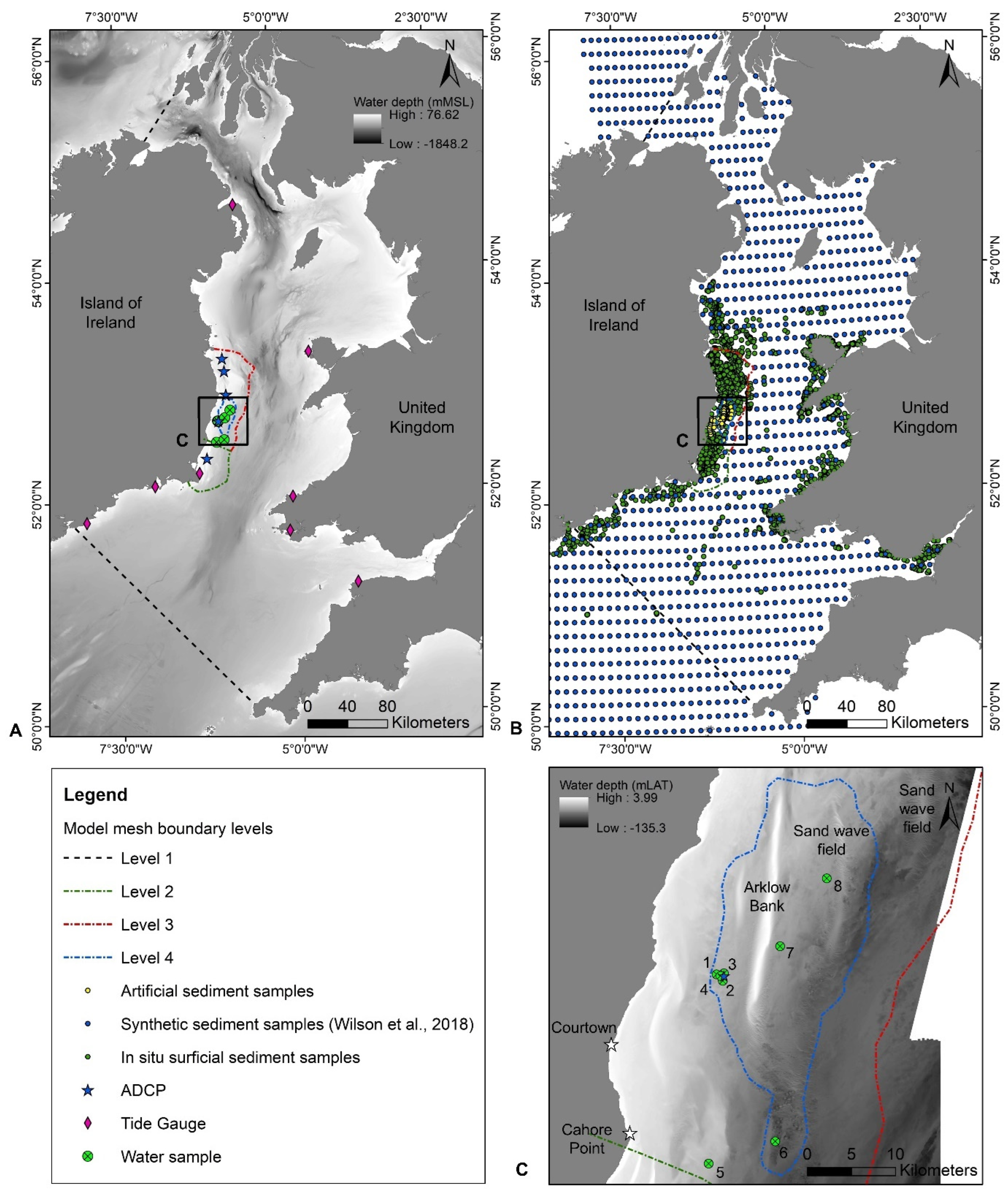
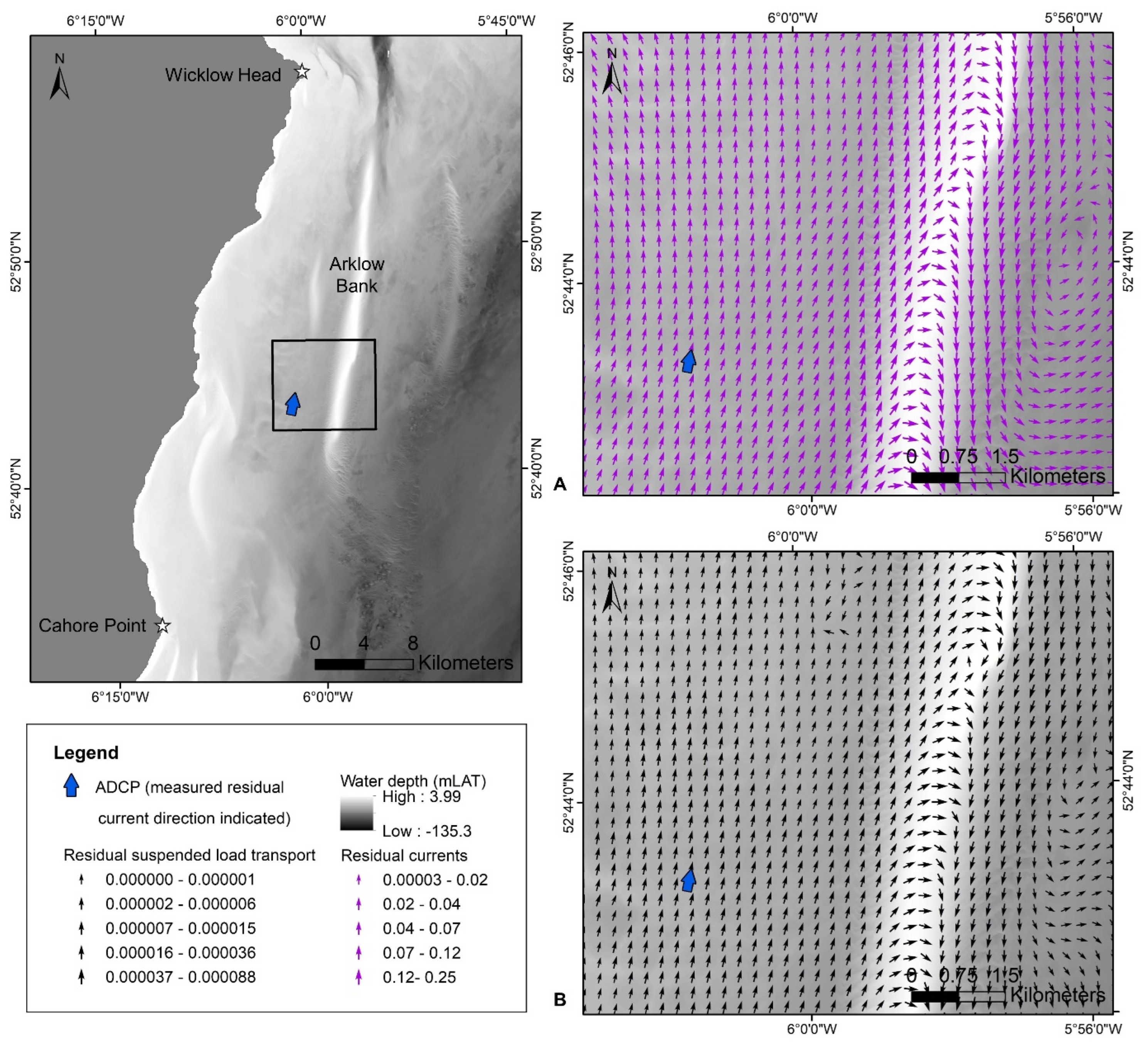
- Using equations developed by previous authors, estimate from the acoustic amplitudes recorded by a 300 kHz ADCP deployed in a tidally dominated shallow shelf setting characterised by complex hydrodynamics and a non-cohesive seabed substrate (Figure 1).
- Explore different model validation techniques to validate the suspended load transport and SSC aspect using a combination of direct sampling and ADCP-estimated .
- Evaluate the applicability and advantages of the new validation techniques presented and provide best practice recommendations for future studies.
2. Methods
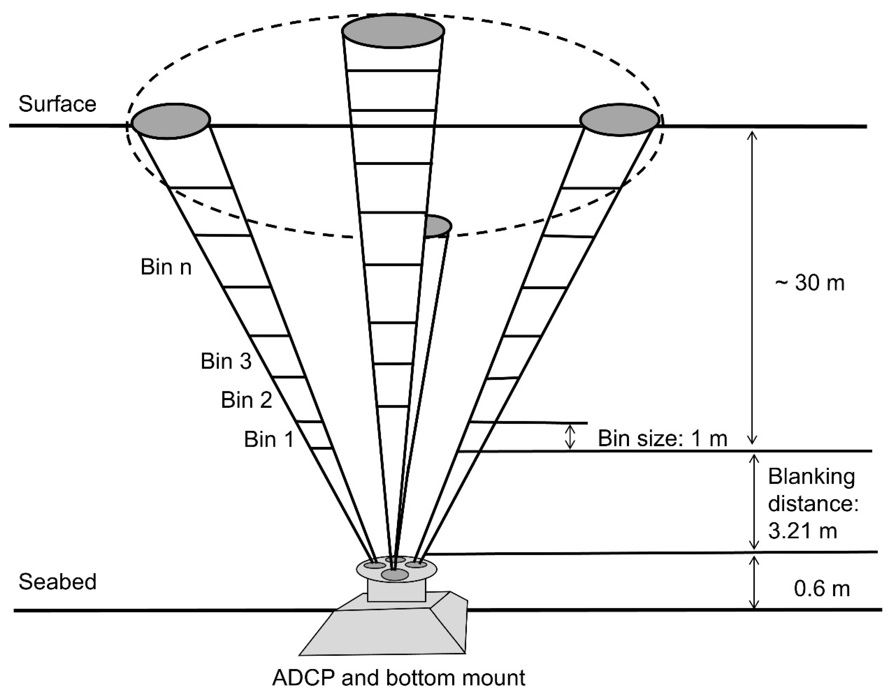
2.1. ADCP Deployment and Water Sample Collection
2.2. ADCP Derived SSC
2.3. Numerical Modelling
2.3.1. HD Modelling
- An addition of 16 bathymetric datasets to increase the accuracy and resolution of the seabed topography in the south-western Irish Sea.
- A total of 15 of these datasets were collected via the INFOMAR (Integrated Mapping for the Sustainabe Development of Ireland’s Marine Resource) programme between 2011 and 2017 onboard a range of survey vessels. These datasets were provided at a spatial resolution between 2 m and 5 m and vertical referenced to the lowest astronomical tide (LAT). These datasets were converted to XYZ format which were then converted to OD Malin. All 15 surveys ultimately replaced the coarse resolution EMODnet (European Marine Observation and Data Network) datasets (referenced to mean sea level (MSL)) along the south-east coast of Ireland in the original model setup.
- The final bathymetric dataset was collected in September/October 2020 onboard the RV Celtic Voyager under the project ‘Mobility of Sediment Waves and Sand Banks in the Irish Sea’ and encompasses approximately 7.2 km2 of the ADCP deployment site (Figure 1). This was to ensure maximum potential model validation using the ADCP at this location.
- A higher 5 m resolution INFOMAR bathymetry dataset, vertically referenced to OD Malin, was produced for Arklow Bank, an area of targeted investigation in terms of sand bank morphodynamics. This dataset replaced the coarser 30 m resolution dataset from the same source.
- This model is designed to couple with a MIKE 21 spectral wave model [85,86] in ongoing studies; therefore, it was necessary to remove the unrealistic high current values at the boundaries evident in the original model in order to feasibly generate sediment transport tables using the quasi-three-dimensional method (Q3D) [82,87]. As a result, the boundary shapes/locations were modified slightly and a varying bed resistance map was generated. In this model, the simulated drag coefficient is calculated by resolving the Manning number () for bed friction [88]. The updated model retains a constant for bed friction of over a majority of the model domain, but is decreased up to along the boundaries.
- An unstructured triangular flexible mesh is refined for the study site. The four levels of resolution (Figure 1) are defined as follows:
- Level 4: From 150 m to 200 m around the Arklow Bank system (approximately 7.2 km2);
- Level 3: A 500 m to 600 m buffer zone, extending from the approximate −70 m water depth contour to the coastline from Howth Head (53.37861°, −6.057222°) to Courtown (52.645°, −6.228333°) and covering any sand banks outside these areas off the south-east coast of Ireland;
- Level 2: From 800 m to 1000 m extending along the −70 m contour to the coast from Courtown to Carnsore Point (52.17056°, −6.355278°);
- Level 1: A 2500 m to 3000 m resolution for the rest of the model domain.
- The ADCP dataset described in Section 2.1 is used as an additional validation point.
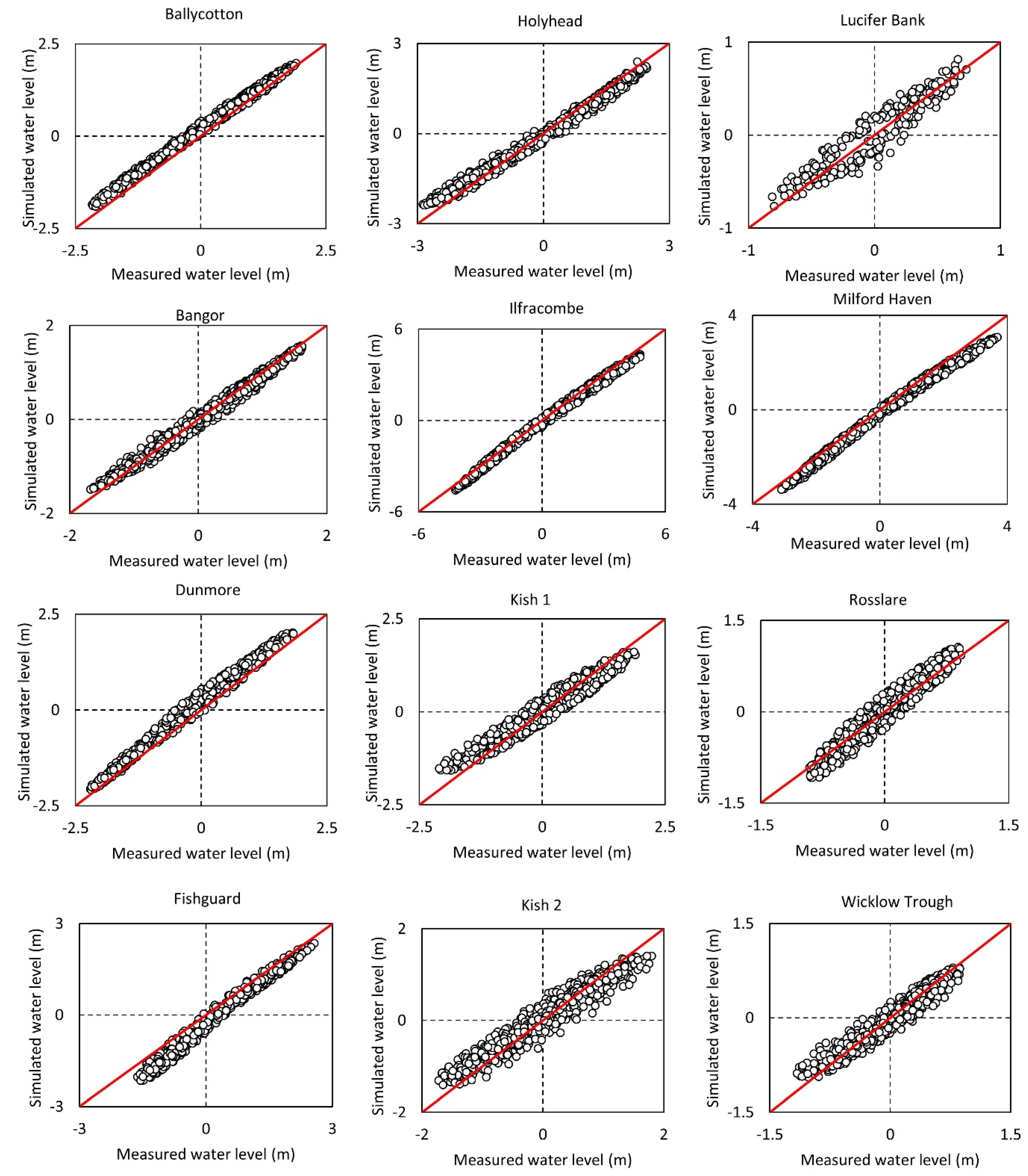
Model Validation
2.3.2. ST Modelling Setup
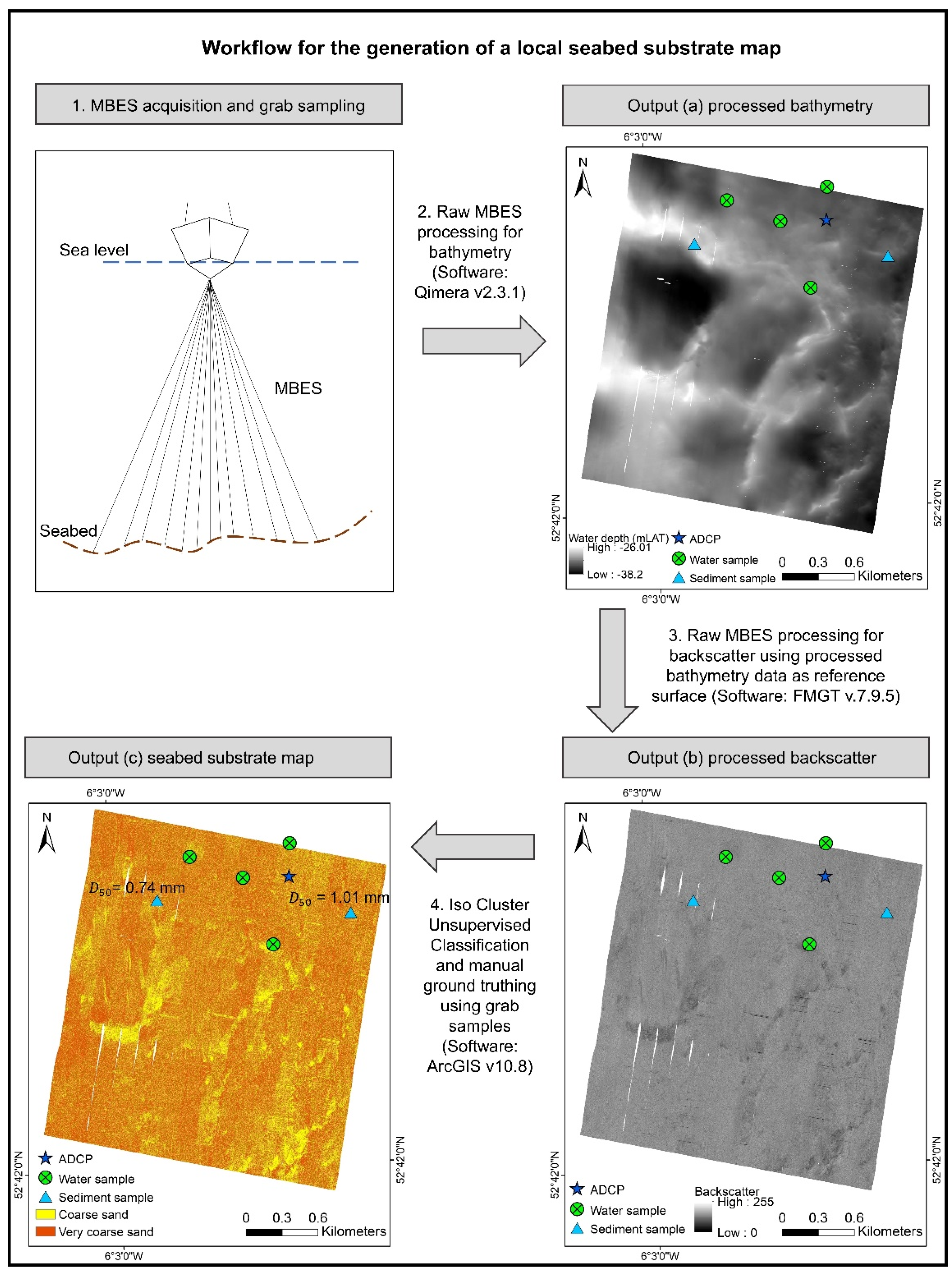
2.4. Generation of Seabed Substrate Map Representing the ADCP Deployment Time-Frame
2.5. Suspended Sediment Model Validation
- Validation of 2D modelled using water sample-based .
- Validation of the flood–ebb characteristics (tidal asymmetry) of (i) 2D modelled suspended load transport and (ii) using ADCP-based datasets.
- ADCP-based validation of 2D modelled using full time series statistics.
- Validation of the 2D modelled peak over a spring–neap cycle using ADCP-based .
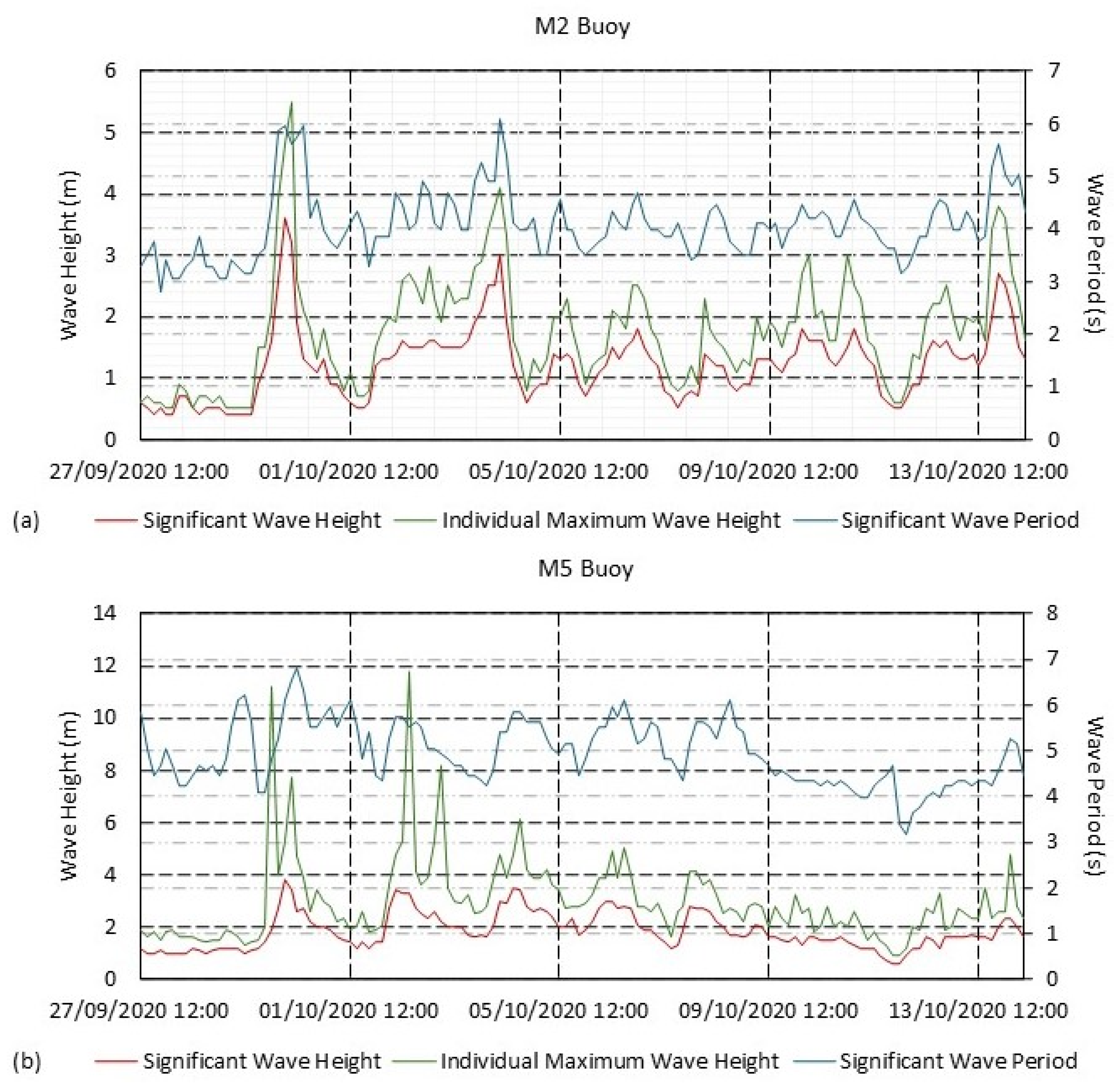
3. Results
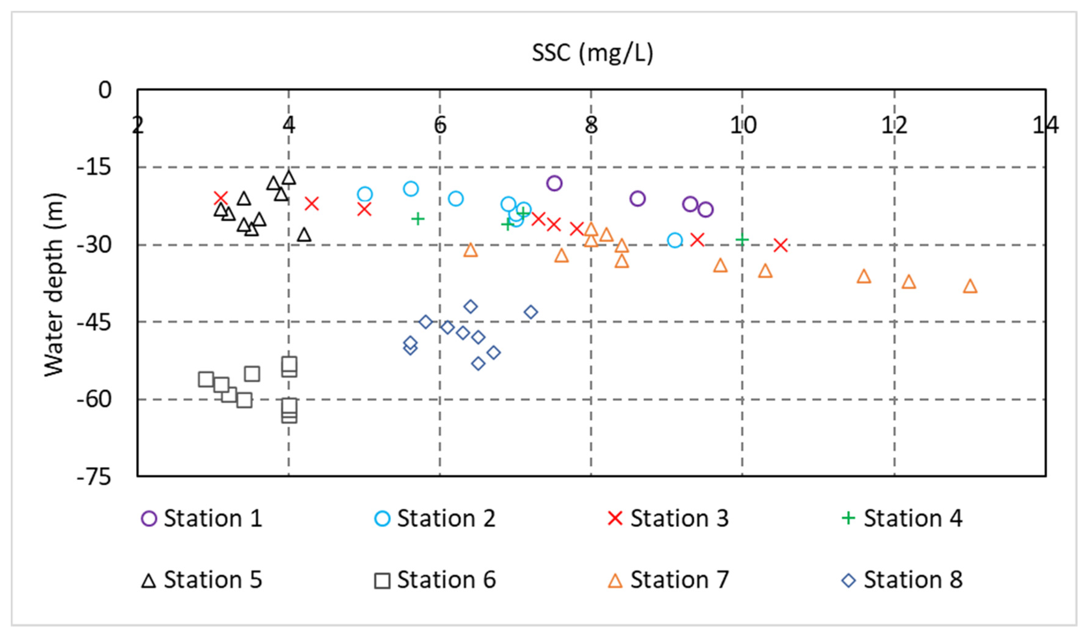
3.1. Water Sample-Based
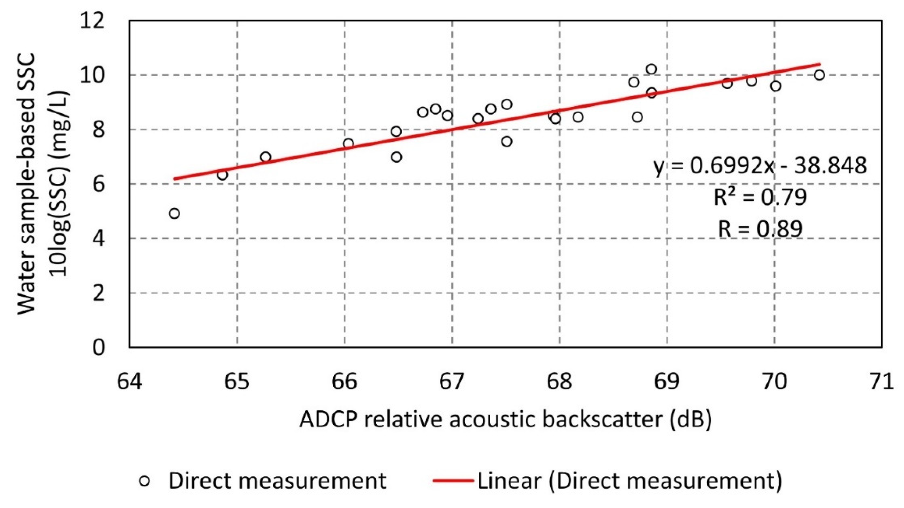
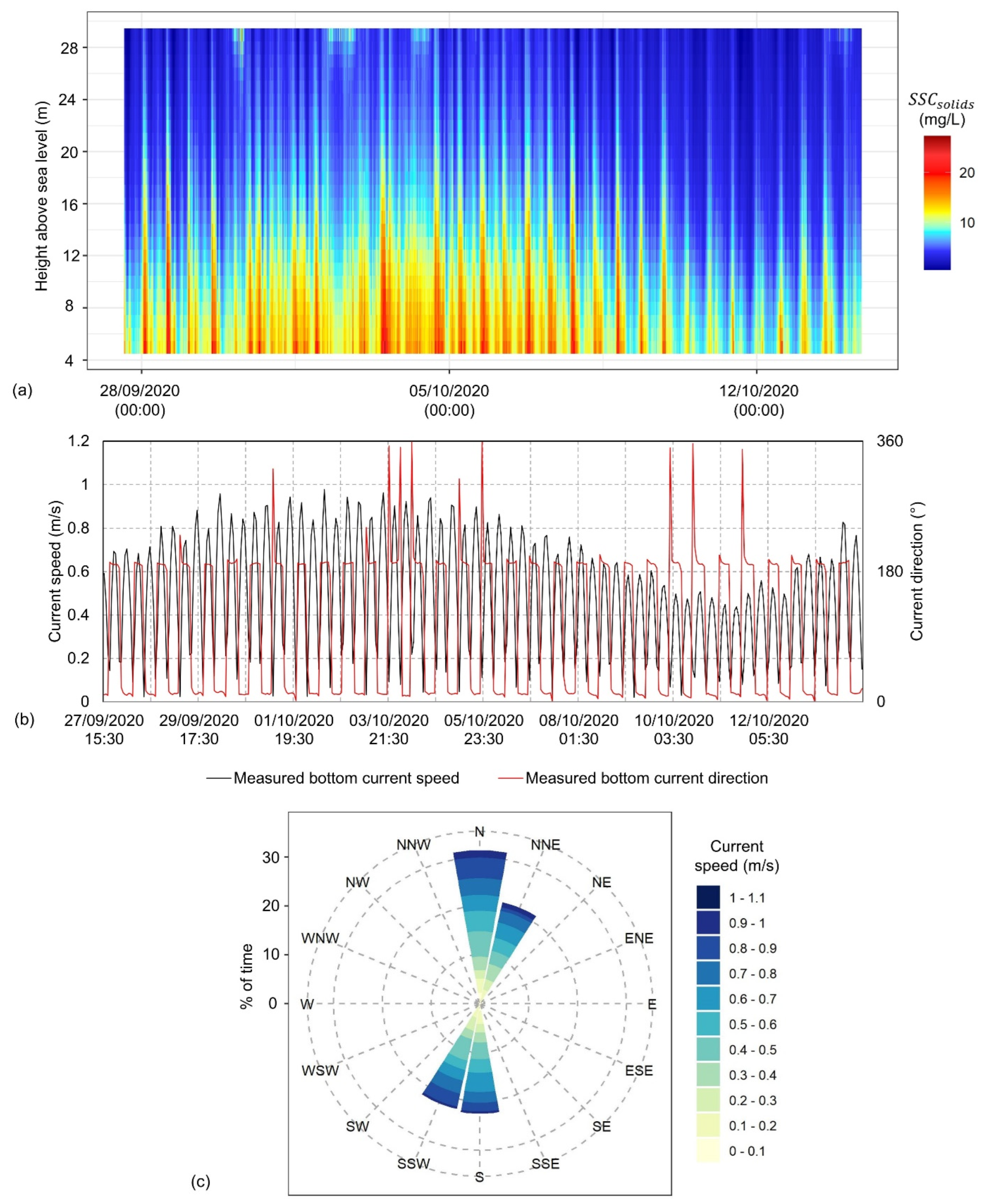
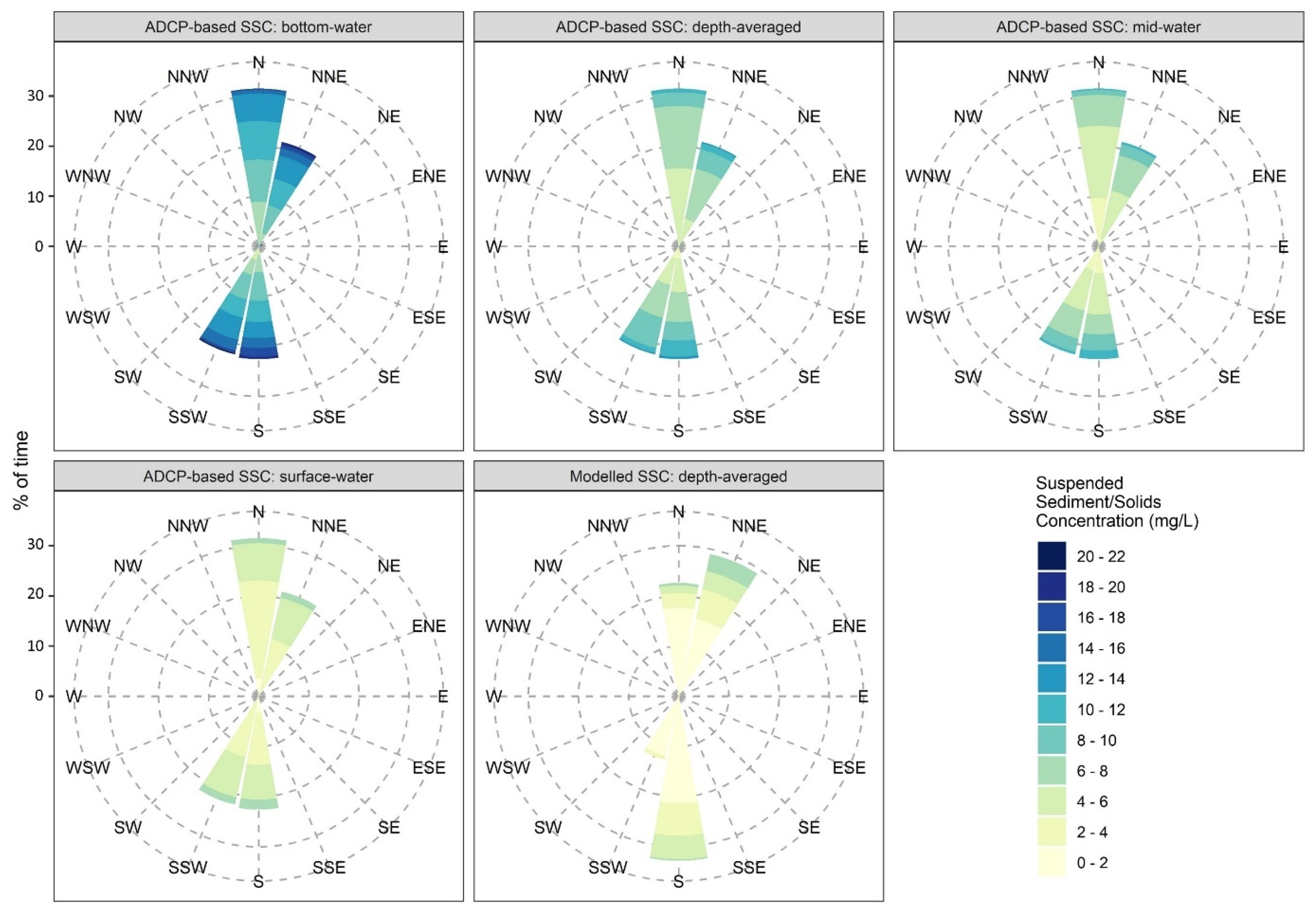
3.2. ADCP Based
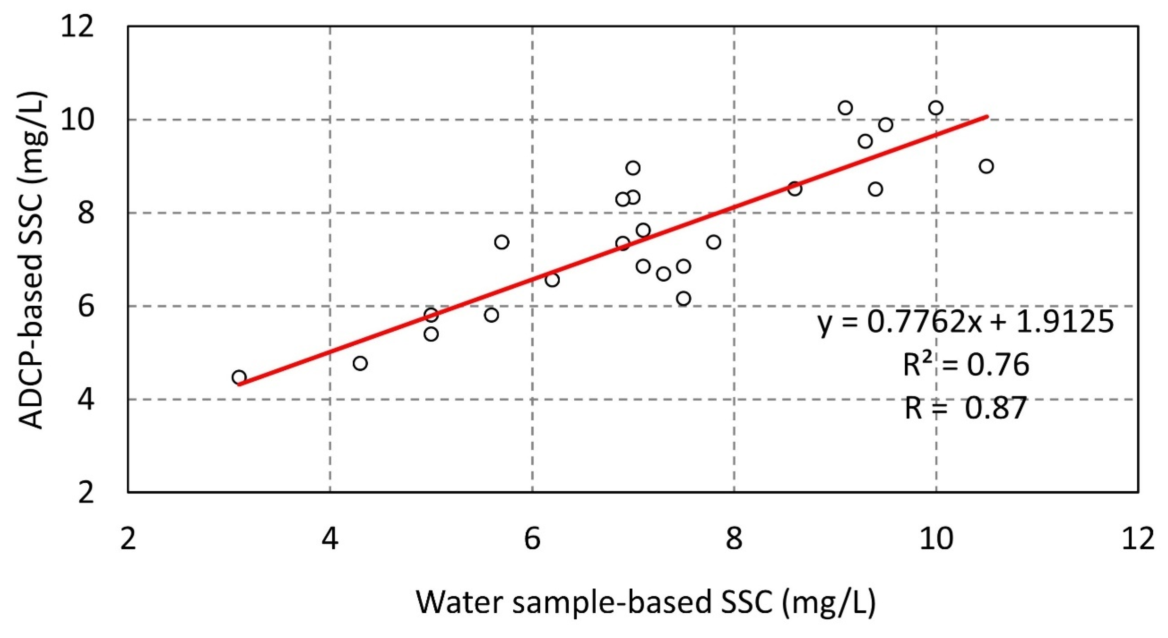
3.3. Comparison Between ADCP-Based and Water Sample-Based
3.4. Suspended Sediment Model Validation
3.4.1. Technique 1: Validation of 2D Modelled Using Water Sample-Based
3.4.2. Technique 2: Validation of the Flood–Ebb Characteristics (Tidal Asymmetry) of (i) 2D Modelled Suspended Load Transport and (ii) , Using ADCP-Based Datasets
Validation of Tidal Asymmetry in 2D Modelled Suspended Load Transport
Validation of Tidal Asymmetry in 2D Modelled
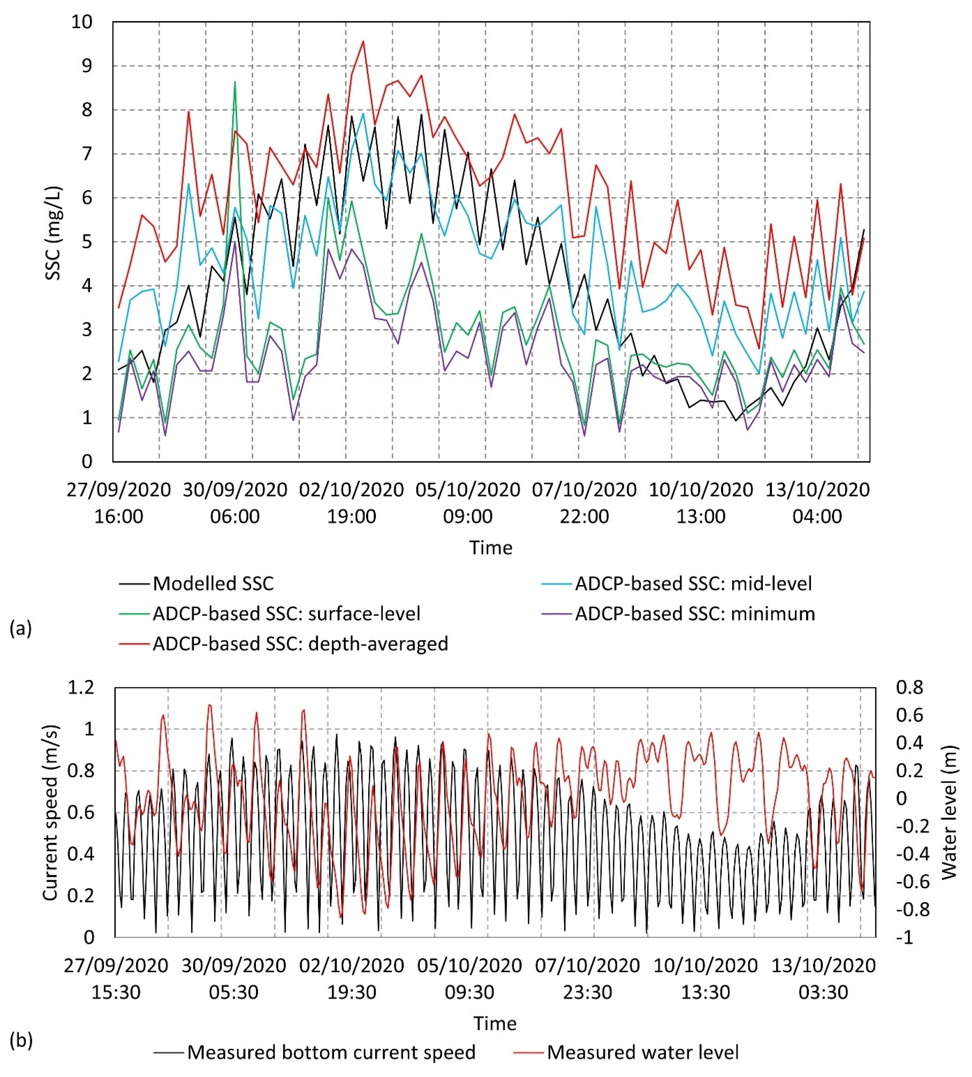
3.4.3. Technique 3: ADCP-Based Validation of 2D Modelled Using Full Time Series Statistics
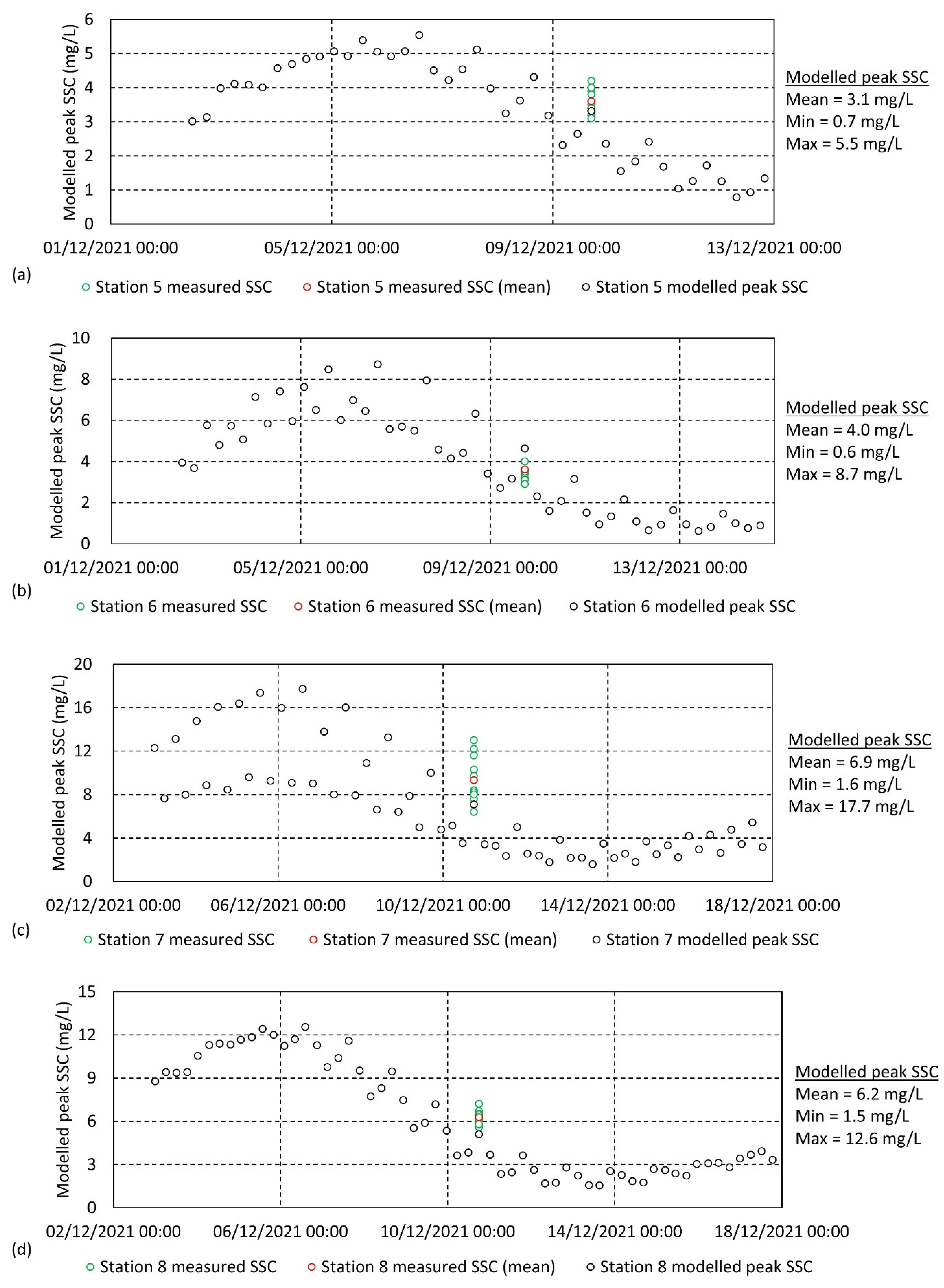
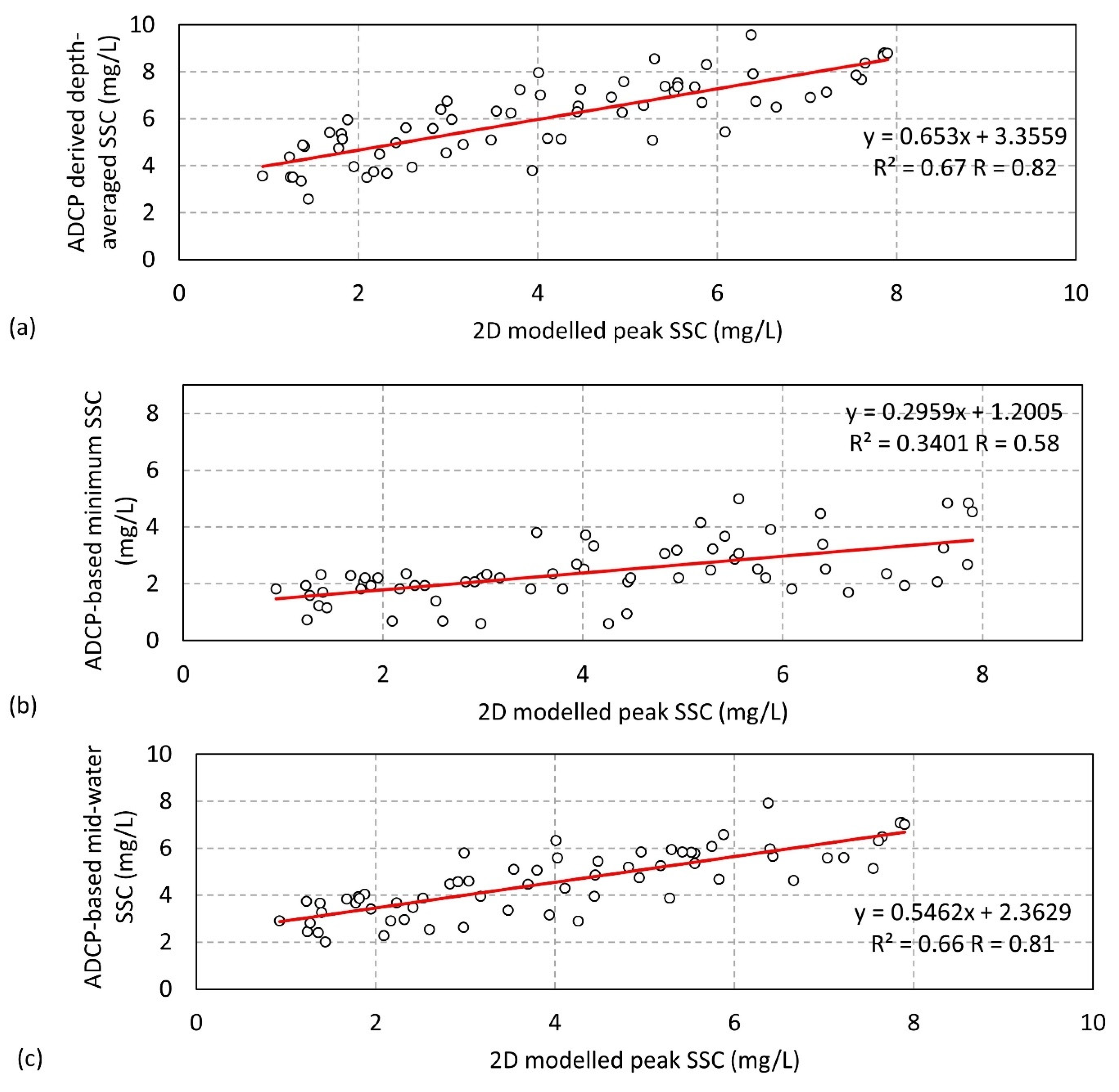
3.4.4. Technique 4: Validation of the 2D Modelled Peak over a Spring–Neap Cycle Using ADCP-Based
4. Discussion
4.1. Evaluation of the Ability to Estimate from ADCP Relative Acoustic Backscatter in a Shallow Shelf Sea Environment
4.2. Evaluation of Model Validation Techniques
- (i)
- The ADCP-based time series, representing approximately 71% of the water column, is estimated for suspended solids concentration. This comprises mainly sediment but may also contain floating micro-organisms and other particles. Therefore, this estimated dataset may naturally display a higher concentration of suspended solids compared to 2D modelled suspended sediment.
- (ii)
- The ADCP-based time series could not capture the bottom 5 m and the top 5 m of the water column. The bottom 5 m of the water column generally contains the highest concentrations of suspended sediment; these concentrations generally decrease as you progress toward the surface. The absence of these strata may skew full time series general (mean/minimum/maximum) statistics.
- (iii)
- Similarly to other studies [11], at every slack water over this spring–neap time-frame the 2D modelled drops down to approximately 0. Realistically, this does not naturally occur in this continental shelf environment, showing the limitation of this depth-integrated approach for suspended sediment transport modelling. This 2D modelled time series does not fully capture the full complexity of the natural environment, therefore, it may not be practical to compare SSC magnitude like for like through these general statistics.
4.3. Potential Improvements/Future Work
- (i)
- The estimation of ADCP-based :
- a.
- Increasing the number of water samples over the ADCP deployment time-frame may further improve correlation between ADCP relative acoustic backscatter and water sample-based
- b.
- Improvements in the existing ADCP deployment setup. This could involve the use of an acoustic release to allow for survey vessel instrumentation to obtain water samples closer to the deployed ADCP. Practically, however, even with the use of an acoustic release, the ability to improve proximity to the ADCP may not be feasible given the relatively high surface current speeds in the south-western Irish Sea and other offshore environments during peak flood and ebb times due to vessel drift. In this case, vessel specifications such as dynamic positioning and operability statistics could be considered more specifically for this purpose if project budget allows.
- c.
- Investigating other techniques such as the use of a hull-mounted or downward-looking ADCPs [67], multi-frequency ADCPs, and other sediment transport measurement-specific instruments such as Aquascat sediment concentration profilers could also be investigated for the purpose of numerical model validation. For example, where a change in PSD is expected, the use of dual frequency ADCPs is expected to provide a high accuracy of results.
- d.
- The methods and techniques developed in this study could be directly applied to other tidally dominated continental shelf seas on a global scale. However, the south-western Irish Sea is dominated by sand to gravelly sand [30] and exhibits a semi-diurnal tidal cycle [30]. Other offshore environments earmarked for ORE developments diversify from these hydrodynamic and sediment characteristics. Therefore, the estimation of from ADCP acoustic backscatter could be further tested in other continental shelf seas around the world.
- (ii)
- Calibration and validation of numerical modelling work:
- a.
- As outlined in Section 4.2, techniques 1, 3, and 4 prove very good validation methods for 2D numerical modelling work. However, technique 2 highlights the limitation of the depth-integrated modelling approach to capture the full dynamics of the natural sediment transport regime. In many coastal and offshore modelling studies the underlying assumptions of a 2D modelling approach is accepted and is commonly the most feasible approach in comparison to other numerical modelling techniques such as 3D and SPH. In making this decision, many variables are commonly considered including model domain size, spatial and temporal resolution requirements, computational power, and project scope, timeline, and budget, and also site-specific environmental variables such as water stratification, the consistency of the vertical current profile, and the complexity of regional scale hydrodynamics and morphodynamics. On a small to medium scale, 3D sediment transport models in coastal and offshore environments are becoming increasingly more feasible. In this case, the direct application of these newly tested validation techniques to a 3D model could be investigated. Additionally, the full 71% coverage of the ADCP-based spatial time series has high potential for additional validation of various layers of the modelled water column. By performing this the limitations of the depth-integrated 2D modelling approach of fully characterising suspended load transport could be compared to a 3D modelling approach.
5. Conclusions
- (1)
- The estimation of from ADCP acoustic backscatter based on sonar equations has proven successful in a tidally dominated shallow shelf sea setting. A strong positive correlation is evident both between water sample-based and ADCP acoustic backscatter (), and water sample-based and ADCP-estimated (). These relationships provide a high degree of confidence in the accuracy of the ADCP-estimated spatial time series.
- (2)
- The suspended sediment transport component of the 2D model is deemed successfully validated using three of the four tested model validation techniques. The successful model validation techniques include the following:
- Validation of 2D modelled using water sample-based .
- Validation of the flood–ebb characteristics (tidal asymmetry) of (i) 2D modelled suspended load transport and (ii) using ADCP-based datasets.
- Validation of the 2D modelled peak over a spring–neap cycle using ADCP-based .
These techniques have produced highly acceptable results for this area of interest and have a high potential to be applicable in other locations. - (3)
- The development of a local seabed substrate map using ground-truthed MBES backscatter proved to be a useful technique to provide crucial information on site-specific seabed sediment characteristics over the ADCP deployment time-frame.
- (4)
- The ADCP-based spatial time series has the potential to provide additional validation of the vertical layers in a 3D model. The application of the ADCP-based techniques in this way could reveal how or if a 3D model could overcome the limitations of a depth-integrated 2D modelling approach in fully characterising the natural variability of in a tidally dominated shallow shelf sea setting. Further investigation is recommended.
- (5)
- The multi-disciplinary method of collecting in situ metocean and sediment dynamic data via acoustic instruments (ADCPs) is a cost-effective procedure for future ORE development projects and other engineering and scientific works.
Author Contributions
Funding
Data Availability Statement
Acknowledgments
Conflicts of Interest
References
- Aijaz, S.; Driscoll, A.; Sayce, A.; Kaegaard, K.; Klabbers, M.; Misra, S. Fine sediment transport modelling for design of port facilities. In Coasts and Ports 2013: 21st Australasian Coastal and Ocean Engineering Conference and the 14th Australasian Port and Harbour Conference; Engineers Australia: Barton, Australia, 2013. [Google Scholar]
- de Schipper, M.A.; Ludka, B.C.; Raubenheimer, B.; Luijendijk, A.P.; Schlacher, T.A. Beach nourishment has complex implications for the future of sandy shores. Nat. Rev. Earth Environ. 2021, 2, 70–84. [Google Scholar] [CrossRef]
- Karambas, T.V.; Samaras, A.G. Soft shore protection methods: The use of advanced numerical models in the evaluation of beach nourishment. Ocean Eng. 2014, 92, 129–136. [Google Scholar] [CrossRef]
- Benassai, G. Introduction to Coastal Dynamics and Shoreline Protection; Wit Press: Southampton, UK, 2006. [Google Scholar]
- Creech, C.T.; Amorim, R.S.; Castanon, A.N.A.O.; Gibson, S.A.; Veatch, W.C.; Lauth, T.J. A planning framework for Improving reliability of inland navigation on the Madeira River in Brazil. In Proceedings of the PIANC-World Congress, Panama City, Panama, 7–11 May 2018; pp. 1–20. [Google Scholar]
- Duman, M.; Kucuksezgin, F.; Atalar, M.; Akcali, B. Geochemistry of the northern Cyprus (NE Mediterranean) shelf sediments: Implications for anthropogenic and lithogenic impact. Mar. Pollut. Bull. 2012, 64, 2245–2250. [Google Scholar] [CrossRef]
- Mcbreen, F.; Wilson, J.G.; Mackie, A.S.Y.; Aonghusa, C.N. Seabed mapping in the southern Irish Sea: Predicting benthic biological communities based on sediment characteristics. Hydrobiologia 2008, 606, 93–103. [Google Scholar] [CrossRef]
- Jones, C.; Magalen, J.; Roberts, J. Wave Energy Converter (WEC) Array Effects on Wave, Current, and Sediment Circulation: Monteray Bay, CA; Sandia National Laboratories: Santa Cruz, CA, USA; Albuquerque, NM, USA, 2014. [Google Scholar]
- Abanades, J.; Greaves, D.; Iglesias, G. Wave farm impact on the beach profile: A case study. Coast. Eng. 2014, 86, 36–44. [Google Scholar] [CrossRef]
- Neill, S.P.; Robins, P.E.; Fairley, I. The Impact of Marine Renewable Energy Extraction on Sediment Dynamics. In Marine Renewable Energy: Resource Characterization and Physical Effects; Yang, Z., Copping, A., Eds.; Springer International Publishing: Berlin/Heidelberg, Germany, 2017; pp. 279–304. [Google Scholar] [CrossRef]
- Robins, P.E.; Neill, S.P.; Lewis, M.J. Impact of tidal-stream arrays in relation to the natural variability of sedimentary processes. Renew. Energy 2014, 72, 311–321. [Google Scholar] [CrossRef]
- Auguste, C.; Nader, J.R.; Marsh, P.; Penesis, I.; Cossu, R. Modelling the influence of Tidal Energy Converters on sediment dynamics in Banks Strait, Tasmania. Renew. Energy 2022, 188, 1105–1119. [Google Scholar] [CrossRef]
- Ivanov, E.; Capet, A.; De Borger, E.; Degraer, S.; Delhez, E.J.; Soetaert, K.; Vanaverbeke, J.; Grégoire, M. Offshore Wind Farm Footprint on Organic and Mineral Particle Flux to the Bottom. Front Mar Sci. 2021, 8, 631799. [Google Scholar] [CrossRef]
- Whitehouse, R.J.S.; Harris, J.M.; Sutherland, J.; Rees, J. The nature of scour development and scour protection at offshore windfarm foundations. Mar. Pollut. Bull. 2011, 62, 73–88. [Google Scholar] [CrossRef]
- IEA. Net Zero by 2050. A Roadmap for the Global Energy Sector. Revised version, October 2021 (4th Revision); International Energy Agency: Paris, France, 2021. [Google Scholar]
- IEA. World Energy Outlook 2022. Revised Version, November 2022. Available online: https://iea.blob.core.windows.net/assets/830fe099-5530-48f2-a7c1-11f35d510983/WorldEnergyOutlook2022.pdf (accessed on 1 September 2023).
- Rivier, A.; Bennis, A.-C.; Pinon, G.; Magar, V.; Gross, M. Parameterization of wind turbine impacts on hydrodynamics and sediment transport. Ocean Dyn. 2016, 66, 1285–1299. [Google Scholar] [CrossRef]
- Baeye, M.; Fettweis, M. In situ observations of suspended particulate matter plumes at an offshore wind farm, southern North Sea. Geo-Mar. Lett. 2015, 35, 247–255. [Google Scholar] [CrossRef]
- Fairley, I.; Masters, I.; Karunarathna, H. The cumulative impact of tidal stream turbine arrays on sediment transport in the Pentland Firth. Renew. Energy 2015, 80, 755–769. [Google Scholar] [CrossRef]
- Harris, J.M.; Whitehouse, R.J.S.; Sutherland, J. Marine scour and offshore wind-Lessons learnt and future challenges. In Proceedings of the International Conference on Offshore Mechanics and Arctic Engineering-OMAE, 2011, Rotterdam, The Netherlands, 19–24 June 2011; pp. 849–858. [Google Scholar] [CrossRef]
- Lind, R.A.; Whitehouse, R.J.S. Understanding and Assessing Scour Development at Offshore Structures. J. Oilfield Technol. 2012, 5, 63–67. [Google Scholar]
- van Berkel, J.; Burchard, H.; Christensen, A.; Mortensen, L.O.; Petersen, O.S.; Thomsen, F. The Effects of Offshore Wind Farms on Hydrodynamics and Implications for Fishes. Oceanography 2020, 33, 108–117. [Google Scholar] [CrossRef]
- Clark, S.; Schroeder, F.; Baschek, B. The Influence of Large Offshore Wind Farms on the North Sea and Baltic Sea–A Comprehensive Literature Review (Report No. HZG Report 2014-6); Helmholtz-Zentrum Geesthacht, Zentrum für Material-und Küstenforschung: Geesthacht, Germany, 2014. [Google Scholar]
- Bat, L.; Sezgin, M.; Sahin, F. Impacts of OWF installations on fisheries: A Literature Review. J. Coast. Life Med. 2013, 1, 241–252. [Google Scholar] [CrossRef]
- Onea, F.; Rusu, L.; Carp, G.B.; Rusu, E. Wave farms impact on the coastal processes—A case study area in the portuguese nearshore. J. Mar. Sci. Eng. 2021, 9, 262. [Google Scholar] [CrossRef]
- Coughlan, M.; Guerrini, M.; Creane, S.; O’Shea, M.; Ward, S.L.; Van Landeghem, K.J.; Murphy, J.; Doherty, P. A new seabed mobility index for the Irish Sea: Modelling seabed shear stress and classifying sediment mobilisation to help predict erosion, deposition, and sediment distribution. Cont. Shelf Res. 2021, 229, 104574. [Google Scholar] [CrossRef]
- Roetert, T.; Raaijmakers, T.; Borsje, B. Cable route optimization for offshore wind farms in morphodynamic areas. In Proceedings of the 27th International Offshore and Polar Engineering Conference, San Francisco, CA, USA, 25–30 June 2017; pp. 595–606. [Google Scholar]
- Harris, J.M.; Whitehouse, R.J.S. Scour management—A risk based approach. In Proceedings of the 6th International Conference of Scour and Erosion (ICSE-6), Paris, France, 27–31 August 2012. [Google Scholar]
- van der Tempel, J.; Zaaijer, M.B.; Subroto, H. The effects of Scour on the design of offshore wind turbines. In Proceedings of the 3rd International Conference on Marine Renewable Energy, Blyth, UK, 7–9 July 2004; pp. 27–35. [Google Scholar]
- Creane, S.; O’Shea, M.; Coughlan, M.; Murphy, J. The Irish Sea bed load parting zone: Is it a mid-sea hydrodynamic phenomenon or a geological theoretical concept? Estuar. Coast. Shelf Sci. 2021, 263, 107651. [Google Scholar] [CrossRef]
- Li, M.Z.; Hannah, C.G.; Perrie, W.A.; Tang, C.C.L.; Prescott, R.H.; Greenberg, D.A. Modelling seabed shear stress, sediment mobility, and sediment transport in the bay of fundy. Can. J. Earth Sci. 2015, 52, 757–775. [Google Scholar] [CrossRef]
- Brown, J.M.; Davies, A.G. Methods for medium-term prediction of the net sediment transport by waves and currents in complex coastal regions. Cont. Shelf Res. 2009, 29, 1502–1514. [Google Scholar] [CrossRef]
- Rivier, A.; Bennis, A.C.; Pinon, G.; Gross, M.; Magar, V. Regional numerical modelling of offshore monopile wind turbine impacts on hydrodynamics and sediment transport. In Proceedings of the Renewable Energies Offshor-1st International Conference on Renewable Energies Offshore, RENEW 2014, Lisbon, Portugal, 23–25 November 2014; pp. 807–814. [Google Scholar] [CrossRef]
- Couldrey, A.J.; Benson, T.; Knaapen, M.A.F.; Marten, K.V.; Whitehouse, R.J.S. Morphological evolution of a barchan dune migrating past an offshore wind farm foundation. Earth Surf. Process Landf. 2020, 45, 2884–2896. [Google Scholar] [CrossRef]
- Neill, S.P.; Couch, S.J. Impact of Tidal Energy Converter (TEC) Array Operation on Sediment Dynamics. In Proceedings of the 9th European Wave and Tidal Energy Conference (EWTEC), Southampton, UK, 5–9 September 2011. [Google Scholar]
- Borsje, B.W.; Roos, P.C.; Kranenburg, W.M.; Hulscher, S.J.M.H. Modeling tidal sand wave formation in a numerical shallow water model: The role of turbulence formulation. Cont. Shelf Res. 2013, 60, 17–27. [Google Scholar] [CrossRef]
- Krabbendam, J.; Nnafie, A.; de Swart, H.; Borsje, B.; Perk, L. Modelling the past and future evolution of tidal sand waves. J. Mar. Sci. Eng. 2021, 9, 1071. [Google Scholar] [CrossRef]
- Leenders, S.; Damveld, J.H.; Schouten, J.; Hoekstra, R.; Roetert, T.J.; Borsje, B.W. Numerical modelling of the migration direction of tidal sand waves over sand banks. Coast. Eng. 2021, 163, 103790. [Google Scholar] [CrossRef]
- Tran-Duc, T.; Phan-Thien, N.; Khoo, B.C. A smoothed particle hydrodynamics (SPH) study of sediment dispersion on the seafloor. Phys. Fluids 2017, 29, 83302. [Google Scholar] [CrossRef]
- Fairley, I.; Masters, I.; Karunarathna, H. Numerical modelling of storm and surge events on offshore sandbanks. Mar. Geol. 2016, 371, 106–119. [Google Scholar] [CrossRef]
- Auguste, C.; Marsh, P.; Nader, J.R.; Penesis, I.; Cossu, R. Modelling morphological changes and migration of large sand waves in a very energetic tidal environment: Banks Strait, Australia. Energies 2021, 14, 3943. [Google Scholar] [CrossRef]
- Ashall, L.M.; Mulligan, R.P.; Law, B.A. Variability in suspended sediment concentration in the Minas Basin, Bay of Fundy, and implications for changes due to tidal power extraction. Coast. Eng. 2016, 107, 102–115. [Google Scholar] [CrossRef]
- Ulses, C.; Estournel, C.; de Madron, X.D.; Palanques, A. Suspended sediment transport in the Gulf of Lions (NW Mediterranean): Impact of extreme storms and floods. Cont. Shelf Res. 2008, 28, 2048–2070. [Google Scholar] [CrossRef]
- Guillén, J.; Palanques, A.; Puig, P.; de Madron, X.D.; Nyffeler, F. Field calibration of optical sensors for measuring suspended sediment concentration in the western Mediterranean. Sci. Mar. 2000, 64, 427–435. [Google Scholar] [CrossRef]
- Downing, J. Twenty-five years with OBS sensors: The good, the bad, and the ugly. Cont. Shelf Res. 2006, 26, 2299–2318. [Google Scholar] [CrossRef]
- Boss, E.; Sherwood, C.R.; Hill, P.; Milligan, T. Advantages and limitations to the use of optical measurements to study sediment properties. Appl. Sci. 2018, 8, 2692. [Google Scholar] [CrossRef]
- Kerr, A.; Cowling, M.J.; Beveridge, C.M.; Smith, M.J.; Parr, A.C.; Head, R.M.; Davenport, J.; Hodgkiess, T. The early stages of marie biofouling and its effect on two types of optical sensors. Environ. Int. 1998, 24, 331–343. [Google Scholar] [CrossRef]
- Matos, T.; Pinto, V.; Sousa, P.; Martins, M.; Fernández, E.; Henriques, R.; Gonçalves, L.M. Design and In Situ Validation of Low-Cost and Easy to Apply Anti-Biofouling Techniques for Oceanographic Continuous Monitoring with Optical Instruments. Sensors 2023, 23, 605. [Google Scholar] [CrossRef]
- Sassi, M.G.; Hoitink, A.J.F.; Vermeulen, B. Impact of sound attenuation by suspended sediment on ADCP backscatter calibrations. Water Resour. Res. 2012, 48, 1–14. [Google Scholar] [CrossRef]
- Landers, M.N.; Straub, T.D.; Wood, M.S.; Domanski, M.M. Sediment acoustic index method for computing continuous suspended-sediment concentrations. In U.S. Geological Survey Techniques and Methods: Book 3, Applications of Hydraulics; U.S. Department of the Interior, U.S. Geological Survey: Reston, VA, USA, 2016; p. 63. [Google Scholar] [CrossRef]
- Baranya, S.; Józsa, J. Estimation of suspended sediment concentrations with ADCP in danube river. J. Hydrol. Hydromech. 2013, 61, 232–240. [Google Scholar] [CrossRef]
- Deines, K.L. Backscatter estimation using broadband acoustic Doppler current profilers. In Proceedings of the IEEE Sixth Working Conference on Current Measurement, San Diego, CA, USA, 11–13 March 1999; pp. 249–253. [Google Scholar] [CrossRef]
- Mullison, J. Backscatter estimation using broadband acoustic doppler current profilers-updated. In Proceedings of the ASCE Hydraulic Measurements & Experimental Methods Conference, Durham, NH, USA, 9–12 July 2017. [Google Scholar]
- Guerrero, M.; Rüther, N.; Haun, S.; Baranya, S. A combined use of acoustic and optical devices to investigate suspended sediment in rivers. Adv. Water Resour. 2017, 102, 1–12. [Google Scholar] [CrossRef]
- Landers, M.N. Review of Methods To Estimate Fluvial Suspended Sediment Characteristics From Acoustic Surrogate Metrics. In Proceedings of the 2nd Joint Interagency Conference, Las Vegas, NV, USA, 27 June–1 July 2010. [Google Scholar]
- Betteridge, K.F.E.; Thorne, P.D.; Cooke, R.D. Calibrating multi-frequency acoustic backscatter systems for studying near-bed suspended sediment transport processes. Cont. Shelf Res. 2008, 28, 227–235. [Google Scholar] [CrossRef]
- Thorne, P.D.; Hurther, D. An overview on the use of backscattered sound for measuring suspended particle size and concentration profiles in non-cohesive inorganic sediment transport studies. Cont. Shelf Res. 2014, 73, 97–118. [Google Scholar] [CrossRef]
- Wall, G.R.; Nystrom, E.A.; Litten, S. Use of an ADCP to Compute Suspended-Sediment Discharge in the Tidal Hudon River, New York; United States Geological Survey Scientific Investigations Report 2006-5055; U.S. Geological Survey: New York, NY, USA, 2006. [Google Scholar]
- Gartner, J.W. Estimating suspended solids concentrations from backscatter intensity measured by acoustic Doppler current profiler in San Francisco Bay, California. Mar. Geol. 2004, 211, 169–187. [Google Scholar] [CrossRef]
- Hill, D.C.; Jones, S.E.; Prandle, D. Derivation of sediment resuspension rates from acoustic backscatter time-series in tidal waters. Cont. Shelf Res. 2003, 23, 19–40. [Google Scholar] [CrossRef]
- Jay, D.A.; Orton, P.; Kay, D.J.; Fain, A.; Baptista, A.M. Acoustic determination of sediment concentrations, settling velocities, horizontal transports and vertical fluxes in estuaries. In Proceedings of the IEEE Sixth Working Conference on Current Measurement (Cat. No.99CH36331), Stoughton, WI, USA, 13 March 1999; pp. 258–263. [Google Scholar] [CrossRef]
- Holdaway, G.P.; Thorne, P.D.; Flatt, D.; Jones, S.E.; Prandle, D. Comparison between ADCP and transmissometer measurements of suspended sediment concentration. Cont. Shelf Res. 1999, 19, 421–441. [Google Scholar] [CrossRef]
- Wang, Y.; Gao, S. ADCP measurements of suspended sediment flux at the entrance to Jiaozhou Bay, western Yellow Sea. Acta Oceanol. Sin. 2013, 32, 96–103. [Google Scholar] [CrossRef]
- de Oliveira, P.A.; Blanco, C.J.C.; Mesquita, A.L.A.; Lopes, D.F.; Filho, M.D.C.F. Estimation of suspended sediment concentration in Guamá River in the Amazon region. Environ. Monit. Assess. 2021, 193, 10661. [Google Scholar] [CrossRef]
- Santos, A.I.; Oliveira, A.; Carinhas, D.; Pinto, J.P.; Freitas, M.C. Hydrodynamic and Sediment Transport Patterns in the Minho and Douro Estuaries (NW Portugal) Based on ADCP Monitoring Data: Part 2—Statistical Interpretation of Bottom Moored Datasets. Coasts 2021, 1, 56–72. [Google Scholar] [CrossRef]
- Moore, S.A.; Le Coz, J.; Hurther, D.; Paquier, A. Using multi-frequency acoustic attenuation to monitor grain size and concentration of suspended sediment in rivers. J. Acoust. Soc. Am. 2013, 133, 1959–1970. [Google Scholar] [CrossRef]
- Dwinovantyo, A.; Manik, H.M.; Prartono, T.; Susilohadi, S. Quantification and Analysis of Suspended Sediments Concentration Using Mobile and Static Acoustic Doppler Current Profiler Instruments. Adv. Acoust. Vib. 2017, 2017, 4890421. [Google Scholar] [CrossRef]
- Creane, S.; Coughlan, M.; O’Shea, M.; Murphy, J. Development and dynamics of sediment waves in a complex morphological and tidal dominant system: Southern Irish Sea. Geosciences 2022, 12, 431. [Google Scholar] [CrossRef]
- Creane, S.; O’Shea, M.; Coughlan, M.; Murphy, J. Hydrodynamic processes controlling sand bank mobility and long-term base stability: A case study of Arklow Bank. Geosciences 2023, 13, 60. [Google Scholar] [CrossRef]
- Creane, S.; O’Shea, M.; Coughlan, M.; Murphy, J. Morphological Modelling to Investigate the Role of External Sediment Sources and Wind and Wave-Induced Flow on Sand Bank Sustainability: An Arklow Bank Case Study. J. Mar. Sci. Eng. 2023, 11, 2027. [Google Scholar] [CrossRef]
- Horrillo-Caraballo, J.M.; Yin, Y.; Fairley, L.; Karunarathna, H.; Masters, I.; Reeve, D.E. A comprehensive study of the tides around the Welsh coastal waters. Estuar. Coast. Shelf Sci. 2021, 254, 107326. [Google Scholar] [CrossRef]
- Wilson, R.J.; Speirs, D.C.; Sabatino, A.; Heath, M.R. A synthetic map of the north-west European Shelf sedimentary environment for applications in marine science. Earth Syst. Sci. Data 2018, 10, 109–130. [Google Scholar] [CrossRef]
- EMODnet Bathymetry Consortium. EMODnet Digital Bathymetry (DTM 2020); EMODnet Bathymetry Consortium: Oostende, Belgium, 2020. [Google Scholar] [CrossRef]
- INFOMAR. INFOMAR Marine Data Download Portal. Available online: https://experience.arcgis.com/experience/50f0522dceaa4582a808558c0cbe8bb0/ (accessed on 10 December 2023).
- Manik, H.M.; Gultom, D.A.; Firdaus; Elson, L. Evaluation of ADCP backscatter computation for quantifying suspended sediment concentration. In IOP Conference Series: Earth and Environmental Science; IOP Publishing: Bristol, UK, 2020. [Google Scholar] [CrossRef]
- Urick, R.J. Principles of Underwater Sound; McGraw-Hill: New York, NY, USA, 1975. [Google Scholar]
- Mackenzie, K.V. Nine-term equation for sound speed in the oceans. J. Acoust. Soc. Am. 1981, 70, 807–812. [Google Scholar] [CrossRef]
- Downing, A.; Thorne, P.; Vincent, C. Backscattering from a suspension in the near field of a piston transducer. J. Acoust. Soc. Am. 1995, 97, 1614–1620. [Google Scholar] [CrossRef]
- Ainslie, M.; McColm, J. A simplified formula for viscous and chemical absorption in sea water. J. Acoust. Soc. Am. 1998, 103, 1671–1672. [Google Scholar] [CrossRef]
- Urick, R.J. The Absorption of Sound in Suspensions of Irregular Particles. J. Acoust. Soc. Am. 1948, 20, 283–289. [Google Scholar] [CrossRef]
- DHI Group. MIKE 21 Flow Model: Hydrodynamic Module User Guide; DHI Group: Horsholm, Denmark, 2017. [Google Scholar]
- DHI Group. MIKE 21 FLOW MODEL FM: Sand Transport Module, Incl. Shoreline Morphology-User Guide; DHI Group: Horsholm, Denmark, 2017. [Google Scholar]
- DHI Group. MIKE 21 Toolbox: User Guide; DHI Group: Horsholm, Denmark, 2017. [Google Scholar]
- DHI Group. MIKE 21 Toolbox: Global Tide Model-Tidal Prediction; DHI Group: Horsholm, Denmark, 2017. [Google Scholar]
- DHI Group. MIKE 21 Spectral Waves FM; DHI Group: Horsholm, Denmark, 2017. [Google Scholar]
- DHI Group. MIKE 21/3 Coupled Model FM; DHI Group: Horsholm, Denmark, 2017. [Google Scholar]
- MIKE DHI. MIKE 21 & MIKE 3 Flow Model FM Sand Transport Module Scientific Documentation; DHI Group: Horsholm, Denmark, 2017. [Google Scholar]
- Manning, R.; Griffith, J.P.; Pigot, T.F.; Vernon-Harcourt, L.F. On the flow of water in open channels and pipes. Trans. Inst. Civ. Eng. Irel. 1890, 20, 161–207. [Google Scholar]
- Engelund, F.; Hansen, E. A Monograph on Sediment Transport in Alluvial Streams; Teknisk Forlag: Copenhagen, Denmark, 1967. [Google Scholar]
- Kaklamanos, J.; Elmy, K. R Package ‘Geotech’. 2016. Available online: http://www.r-project.org/ (accessed on 4 October 2022).
- EMODnet Geology, Seabed Substrates. Available online: https://emodnet.ec.europa.eu/geonetwork/srv/eng/catalog.search#/metadata/67602462-9e00-40e6-98d5-1f560a010855/ (accessed on 13 June 2025).
- British Geological Survey. BGS Seabed Sediments 250k Version 3.0; British Geological Survey: Keyworth, UK, 2011. [Google Scholar] [CrossRef]
- Westhead, K.; Doce, D.D.; Cooper, R.; Stevenson, A. User Guide for the British Geological Survey DiGSBS250K Dataset; British Geological Survey Internal Report; NERC: Atlanta, GA, USA, 2010. [Google Scholar]
- Parnum, I.M.; Gavrilov, A.N. High-frequency multibeam echo-sounder measurements of seafloor backscatter in shallow water: Part 1–Data acquisition and processing. Int. J. Soc. Underw. Technol. 2011, 30, 3–12. [Google Scholar] [CrossRef]
- Innangi, S.; Barra, M.; Di Martino, G.; Parnum, I.M.; Tonielli, R.; Mazzola, S. Reson SeaBat 8125 backscatter data as a tool for seabed characterization (Central Mediterranean, Southern Italy): Results from different processing approaches. Appl. Acoust. 2015, 87, 109–122. [Google Scholar] [CrossRef]
- Pillay, T.; Cawthra, H.C.; Lombard, A.T. Characterisation of seafloor substrate using advanced processing of multibeam bathymetry, backscatter, and sidescan sonar in Table Bay, South Africa. Mar. Geol. 2020, 429, 106332. [Google Scholar] [CrossRef]
- Wentworth, C.K. A Scale of Grade and Class Terms for Clastic Sediments. J. Geol. 1922, 30, 377–392. [Google Scholar] [CrossRef]
- Evans, W.; Benetti, S.; Sacchetti, F.; Jackson, D.W.T.; Dunlop, P.; Monteys, X. Bedforms on the northwest Irish Shelf: Indication of modern active sediment transport and over printing of paleo-glacial sedimentary deposits. J. Maps. 2015, 11, 561–574. [Google Scholar] [CrossRef]
- Flanagan, J.D.; Dias, F.; Terray, E.; Strong, B.; Dudley, J. Extreme Water Waves off the West Coast of Ireland: Analysis of ADCP Measurements. In Proceedings of the 26th International Ocean and Polar Engineering Conference, Rhodes, Greece, 25 June–1 July 2016. [Google Scholar]

| Location | Comparison Time-Frame | Instrument (Tide Gauge (TG) or ADCP) | MBE (m) | RMSE (m) | R |
|---|---|---|---|---|---|
| Wicklow (ADCP) (52.95601°, −5.90135°) | 30 September 2009 (00:00)–26 October 2009 (11:00) | ADCP | 0.02 | 0.16 | 0.97 |
| Lucifer Bank (52.3867°, −6.2183°) | 27 June 2005 (20:00)–8 July 2005 (11:10) | ADCP | −0.01 | 0.13 | 0.97 |
| Kish Bank 1 (53.28422°, −5.9361°) | 23 August 2012 (12:50)–19 September 2012 (11:20) | ADCP | −0.02 | 0.22 | 0.98 |
| Kish Bank 2 (53.16978°, −5.912767°) | 23 August 2012 (15:00)–18 September 2012 (05:10) | ADCP | 0.01 | 0.24 | 0.98 |
| Ballycotton (51.8278°, −8.0007°) | 1 May 2021 (00:00)–31 May 2021 (23:00) | TG | −0.196 | 0.22 | 0.99 |
| Bangor (54.665°, −5.669167°) | 1 May 2021 (00:00)–31 May 2021 (23:00) | TG | 0.00 | 0.12 | 0.99 |
| Dunmore (52.1477°, −6.9919°) | 1 May 2021 (00:00)–31 May 2021 (23:00) | TG | −0.217 | 0.25 | 0.99 |
| Fishguard (52.01272°, −4.982778°) | 1 May 2021 (00:00)–31 May 2021 (23:00) | TG | 0.00 | 0.17 | 0.99 |
| Ilfracombe (51.211139°, −4.112389°) | 1 May 2021 (00:00)–31 May 2021 (23:00) | TG | 0.18 | 0.26 | 1.00 |
| Milford Haven (51.70686°, −5.050639°) | 1 May 2021 (00:00)–31 May 2021 (23:00) | TG | 0.20 | 0.24 | 1.00 |
| Rosslare (52.254600°, −6.334861°) | 1 May 2021 (00:00)–31 May 2021 (23:00) | TG | −0.02 | 0.16 | 0.98 |
| Holyhead (53.30889°, −4.630556°) | 1 May 2021 (00:00)–31 May 2021 (23:00) | TG | 0.0001 | 0.22 | 0.99 |
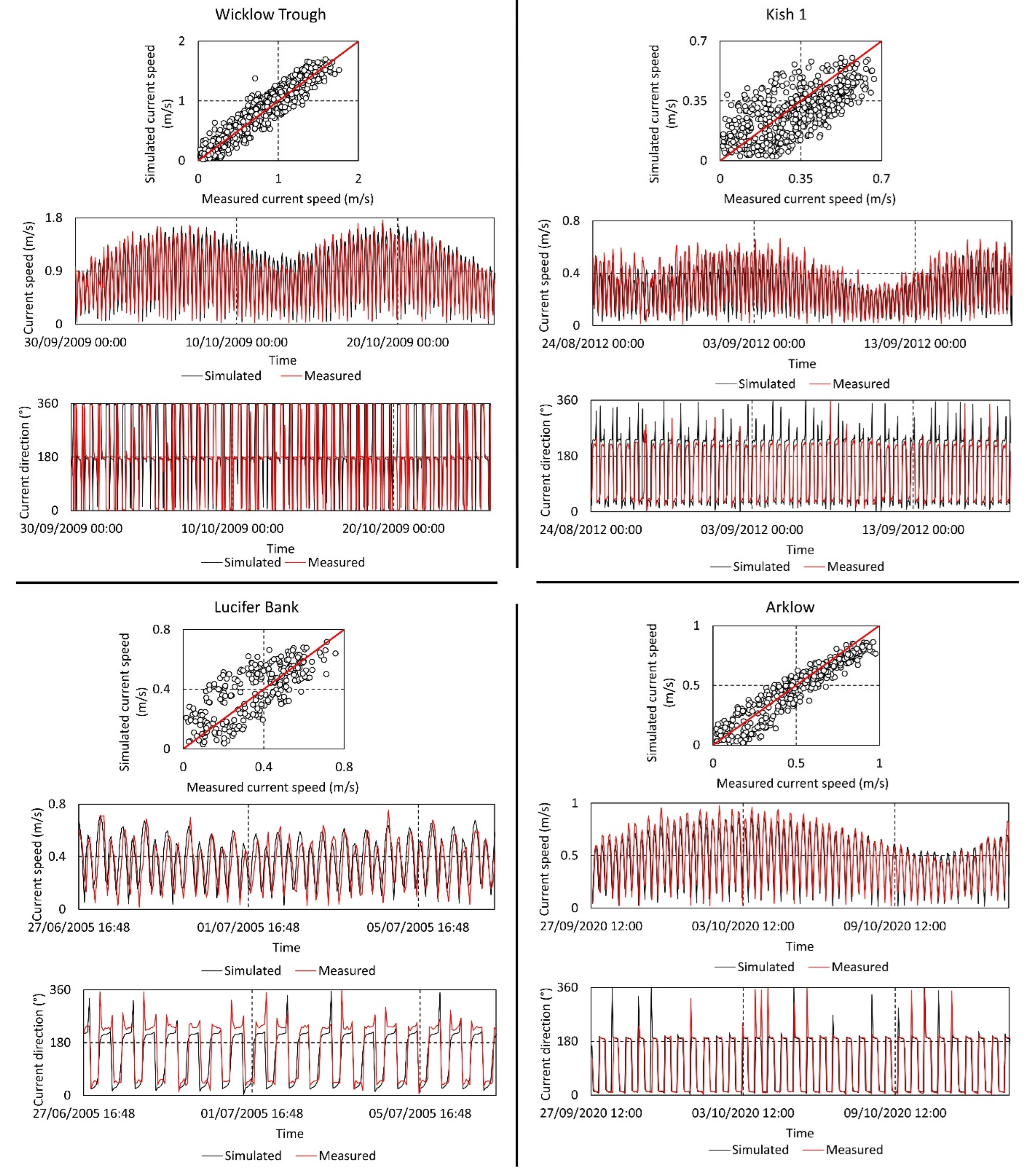
| Location | Data Collection Period | MBE (m/s) | RMSE (m/s) | R | SI (%) |
|---|---|---|---|---|---|
| Arklow (52.72153°, −6.0278°) | 27 September 2020 (14:20)–10 October 2020 (09:10) | 0.02 | 0.10 | 0.95 | 19.57 |
| Kish Bank 1 (53.28422°, −5.9361°) | 23 August 2012 (12:50)–19 September 2012 (11:20) | 0.04 | 0.11 | 0.84 | 37.33 |
| Wicklow Trough (52.95601°, −5.90135°) | 30 September 2009 (00:00)–26 October 2009 (11:00) | −0.05 | 0.19 | 0.95 | 22.62 |
| Lucifer Bank (52.3867°, −6.2183°) | 27 June 2005 (20:00)–8 July 2005 (11:10) | −0.03 | 0.13 | 0.85 | 35.89 |
| Survey Code | Site | Station ID | Date Time (UTC) of Sample | Location | Water Depth at Station (m) | Water Depth of Samples (m) | Sampling Interval (m) | Number of Successful Samples | Range of Processed SSC (mg/L) | Mean Across All Samples (mg/L) | Approx. Tide Time |
|---|---|---|---|---|---|---|---|---|---|---|---|
| CV20010 | ADCP | 1 | 27 September 2020 13:32 | −6.040°, 52.7223° | −34 | −23 to −18 | 1 | 4 | 7.5 to 9.5 | 8.7 | Slack tide |
| CV20036 | ADCP | 2 | 10 October 2020 07:03 | −6.030°, 52.716° | −34 | −29 to −19 | 1 | 8 | 5 to 9.1 | 6.7 | Peak ebb |
| CV20036 | ADCP | 3 | 10 October 2020 13:10 | −6.028°, 52.724° | −36 | −30 to −21 | 1 | 8 | 3.1 to 10.5 | 6.9 | Peak flood |
| CV20036 | ADCP | 4 | 13 October 2020 10:30 | −6.033°, 52.722° | −34 | −29 to −24 | 1 | 4 | 5.7 to 10 | 7.4 | Peak ebb |
| CV21034 | D1 T | 5 | 9 December 2021 17:00 | −6.066°, 52.532° | −32 | −28 to −17 | 1 | 10 | 3.1 to 4.2 | 3.6 | Peak ebb |
| CV21034 | D1 | 6 | 9 December 2021 17:57 | −5.953°, 52.551° | −68 | −64 to −53 | 1 | 10 | 2.9 to 4.0 | 3.6 | Peak ebb |
| CV21034 | 8 T | 7 | 10 December 2021 18:04 | −5.931°, 52.749° | −42 | −38 to −27 | 1 | 12 | 6.4 to 13.0 | 9.3 | Peak ebb |
| CV21034 | 8 | 8 | 10 December 2021 18:50 | −5.848°, 52.816° | −57 | −53 to −42 | 1 | 10 | 5.6 to 7.2 | 6.3 | Peak ebb |
| Statistic | (mg/L) | (mg/L) | |||
|---|---|---|---|---|---|
| Depth-Averaged | Bottom-Water | Mid-Water | Surface-Water | ||
| Min | 2.29 | 3.85 | 1.86 | 0.66 | 0.00 |
| Mean | 6.79 | 10.51 | 5.63 | 3.61 | 1.62 |
| Max | 13.37 | 21.84 | 11.48 | 6.95 | 7.90 |
| Standard deviation | 2.07 | 3.09 | 1.94 | 1.32 | 1.91 |
| Variance | 4.29 | 9.52 | 3.74 | 1.74 | 3.63 |
Disclaimer/Publisher’s Note: The statements, opinions and data contained in all publications are solely those of the individual author(s) and contributor(s) and not of MDPI and/or the editor(s). MDPI and/or the editor(s) disclaim responsibility for any injury to people or property resulting from any ideas, methods, instructions or products referred to in the content. |
© 2025 by the authors. Licensee MDPI, Basel, Switzerland. This article is an open access article distributed under the terms and conditions of the Creative Commons Attribution (CC BY) license (https://creativecommons.org/licenses/by/4.0/).
Share and Cite
Creane, S.; O’Shea, M.; Coughlan, M.; Murphy, J. The Estimation of Suspended Solids Concentration from an Acoustic Doppler Current Profiler in a Tidally Dominated Continental Shelf Sea Setting and Its Use as a Numerical Modelling Validation Technique. Water 2025, 17, 1788. https://doi.org/10.3390/w17121788
Creane S, O’Shea M, Coughlan M, Murphy J. The Estimation of Suspended Solids Concentration from an Acoustic Doppler Current Profiler in a Tidally Dominated Continental Shelf Sea Setting and Its Use as a Numerical Modelling Validation Technique. Water. 2025; 17(12):1788. https://doi.org/10.3390/w17121788
Chicago/Turabian StyleCreane, Shauna, Michael O’Shea, Mark Coughlan, and Jimmy Murphy. 2025. "The Estimation of Suspended Solids Concentration from an Acoustic Doppler Current Profiler in a Tidally Dominated Continental Shelf Sea Setting and Its Use as a Numerical Modelling Validation Technique" Water 17, no. 12: 1788. https://doi.org/10.3390/w17121788
APA StyleCreane, S., O’Shea, M., Coughlan, M., & Murphy, J. (2025). The Estimation of Suspended Solids Concentration from an Acoustic Doppler Current Profiler in a Tidally Dominated Continental Shelf Sea Setting and Its Use as a Numerical Modelling Validation Technique. Water, 17(12), 1788. https://doi.org/10.3390/w17121788