Article

Creating Forested Wetlands for Improving Ecosystem Services and Their Potential Benefits for Rural Residents in Metropolitan Areas

1
Law School, East China University of Political Science and Law, Shanghai 200042, China
2
College of Architecture and Urban Planning, Tongji University, Shanghai 200092, China
3
Shanghai Land Consolidation and Rehabilitation Center, Shanghai 200003, China
4
Technology Innovation Center for Land Spatial Eco-Restoration in Metropolitan Area, Ministry of Natural Resources of the People’s Republic of China, Shanghai 200003, China
5
School of Ecological and Environmental Sciences, East China Normal University, Shanghai 200241, China
6
Ecological Technique and Engineering College, Shanghai Institute of Technology, Shanghai 201418, China
*
Author to whom correspondence should be addressed.
These authors contributed equally to this work.
Water 2025, 17(11), 1682; https://doi.org/10.3390/w17111682
Submission received: 3 May 2025 / Revised: 25 May 2025 / Accepted: 30 May 2025 / Published: 2 June 2025

Abstract

Intensive farming in urban suburbs often causes habitat loss, soil erosion, wastewater discharge, and agricultural productivity decline, threatening long-term benefits for the local community. We developed a nature-based solution for sustainable land restoration by establishing “Green Treasure Island” (GTI). The aim of this study is to evaluate the ecological restoration effectiveness of GTI and explore its feasibility and replicability for future applications. The core eco-functional zone of GTI—a 7 hm2 forested wetland—embedded a closed-loop framework that integrates land consolidation, ecological restoration, and sustainable land utilization. The forested wetland efficiently removed 65% and 74% of dissolved inorganic nitrogen and phosphorus from agricultural runoff, raised flood control capacity by 22%, and attracted 48 bird species. Additionally, this biophilic recreational space attracted over 3400 visitors in 2022, created green jobs, and promoted local green agricultural product sales. Through adaptive management and nature education activities, GTI evolved into a landmark that represents local natural–social characteristics and serves as a publicly accessible natural park for both rural and urban residents. This study demonstrates the feasibility of creating GTI for improving ecosystem services, providing a practical, low-cost template that governments and local managers can replicate in metropolitan rural areas worldwide to meet both ecological and development goals.

1. Introduction

Urban sprawl and rural development in developing countries often transform rural areas from green to grey, leading to habitat loss, soil erosion, wastewater discharge, and agricultural productivity decline [1,2]. These severe changes in key environmental factors will profoundly alter the traditional lifestyle and livelihood of residents, potentially compromising their wellbeing and long-term benefits [3]. Many existing solutions rely on engineering measures to address ecosystem degradation in rural areas. However, sustaining the effectiveness of these ecological restoration projects post-implementation often presents a challenge [4]. For instance, present applications are dominated by single-function constructed wetlands that prioritize nutrient removal but neglect biodiversity and socio-economic co-benefits [5]. Accordingly, expanding objectives beyond biophysical objectives to integrate environmental and socio-economic factors could enhance ecological restoration projects’ long-term sustainability. Studies have suggested that incorporating food and other benefits into restored ecosystems would promote connections between people and ecosystems, which would improve restoration outcomes and sustain local communities [6]. Addressing these gaps requires field-scale tests that link nutrient control, biodiversity gains, and local income in metropolitan rural areas to achieve such complementary land-use goals.
We proposed a nature-based, people-centered approach to sustainable land restoration, aiming to establish a “Green Treasure Island (GTI)” for rural communities. This approach functions through a closed-loop framework that integrates land consolidation, ecological restoration, and sustainable land utilization, structured as follows: ① Land Consolidation and Agricultural Enhancement: Farmland area was expanded through land consolidation, thereby enhancing the overall agricultural production capacity of the local region. Simultaneously, degraded timberland and abandoned structures were restored into a multifunctional forested wetland. The expanded farmland not only generates immediate economic benefits for rural communities but also secures funding for the long-term management of multifunctional forested wetland. ② Synergistic Coupling of Farmland and Forested Wetland Ecosystems: The restored forested wetland serves as a natural filter, reducing nitrogen and phosphorus runoff from adjacent farmland. These ecosystems also act as biodiversity hotspots and hydrological buffers, enhancing critical ecosystem services such as water purification, flood regulation, and habitat conservation [7]. ③ Creation of Ecotourism and Cultural Value: As ecosystems evolve, biodiversity increases, transforming the integrated agro-forestry-wetland landscape into a distinctive ecological and cultural landmark. This, in turn, attracts urban tourists, allowing rural communities to generate income by offering ecotourism services and selling traditional crafts. ④ Community-Driven Sustainability: Empowered by the tangible benefits of ecosystem restoration, residents actively participate in the protection and sustainable use of GTI, thereby promoting rural socio-economic development [8]. By leveraging sectoral funds from territorial spatial management together with policy tools, we implemented the GTI approach in Youhao Village, located in Shanghai’s agricultural region.
In this study, water-quality monitoring, hydrological assessment, biodiversity surveys, and socio-economic tracking were conducted during 2022 to (i) quantify the forested wetland’s effectiveness in removing nutrients from agricultural runoff and improving flood control capacity; (ii) assess its co-benefits for biodiversity conservation and rural community; and (iii) explore the feasibility of GTI model and its potential for future application. By linking field evidence with management innovations, the study deepened our understanding of forested wetland restoration and proposed key strategies for sustainable land restoration, providing a basis for future application.

2. Materials and Methods

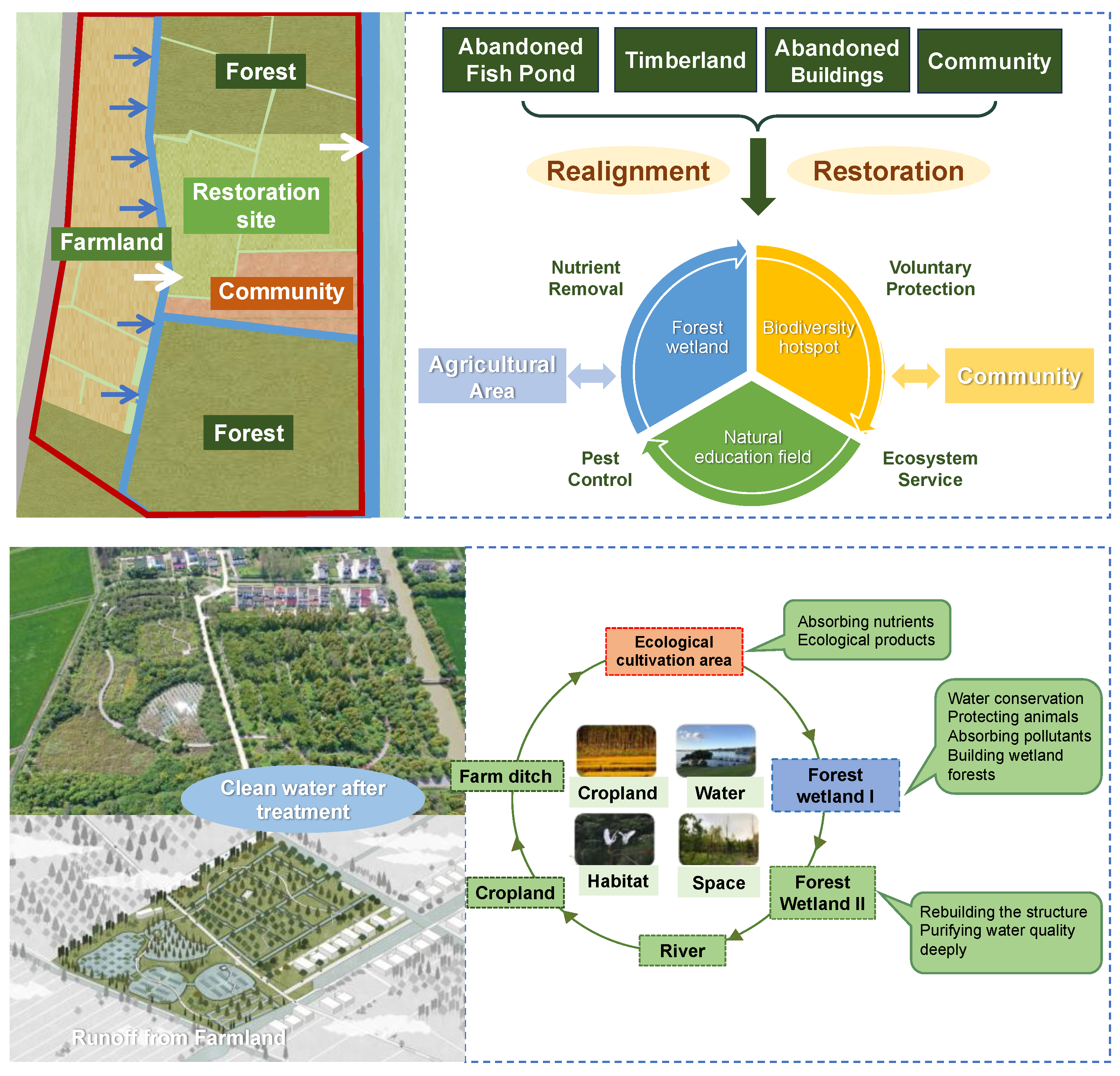
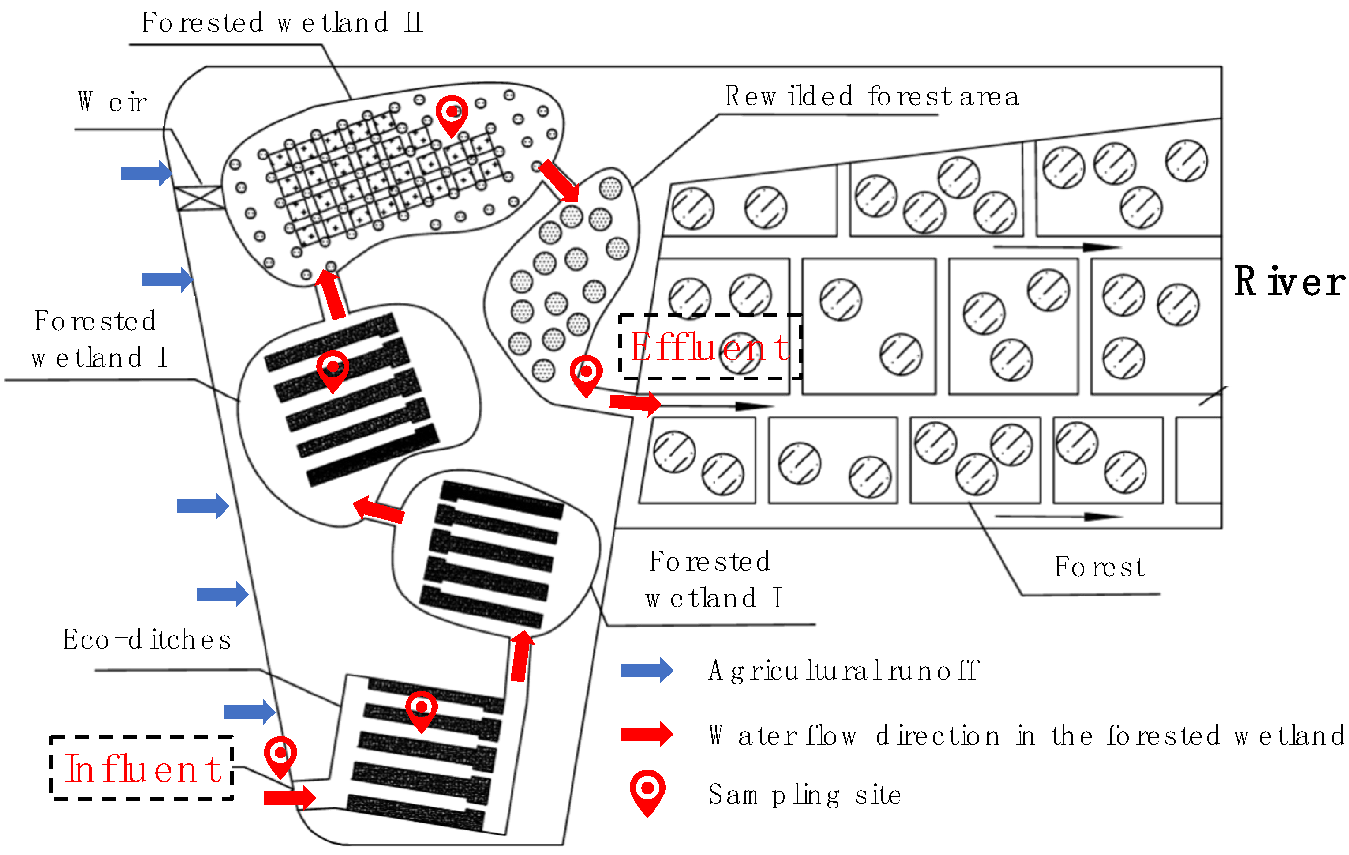
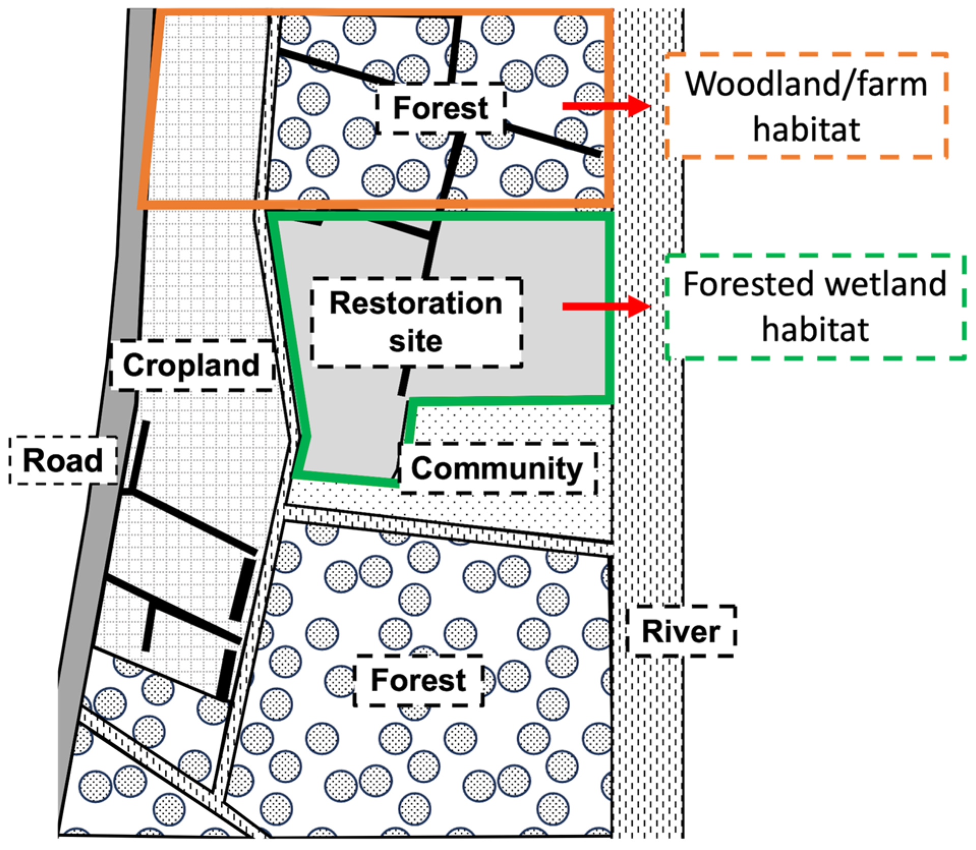
2.1. The Creation of Green Treasure Island

We conducted long-term field demonstrations and case studies in Youhao Village, Langxia Town, Jinshan District, Shanghai, China. Jinshan is a key grain-producing district yet remains economically underdeveloped. In 2022, its per-capita GDP and disposable income were only 75% and 68% of the Shanghai averages, making land-use optimization and ecosystem service improvement pressing goals. Youhao Village covers 331 hm2, more than 80% of which is ecological land, including 200 hm2 of rice paddies and 87 hm2 of shelter forest.
A recent land-consolidation project converted 9.28 hm2 of greyfields and abandoned aquacultural ponds into intensive farming systems, enhancing the agricultural productivity of local communities but also causing agricultural non-point-source pollution problems. In conjunction with agricultural development, we preserved local forest and wetland resources and established 7 hm2 of GTI to mitigate ecosystem losses. The pivotal ecological functional zone of GTI, consisting of four eco-functional units (Eco-ditches, Forested Wetland I, Forested Wetland II, and Rewilded Forest Area), was established through the utilization of local forest and wetland resources. The eastern part of GTI comprised nursery plots and monocultures of conifers; the northern boundary adjoined shelter forests over 20 years old, while the southern edge bordered the village community (Figure 1). GTI absorbs nitrogen and phosphorus discharged from rice paddies, converting them into wetland biomass. It also prevents soil erosion, maintains water balance, and provides diverse habitats for birds and other wildlife.

2.2. Ecological Monitoring

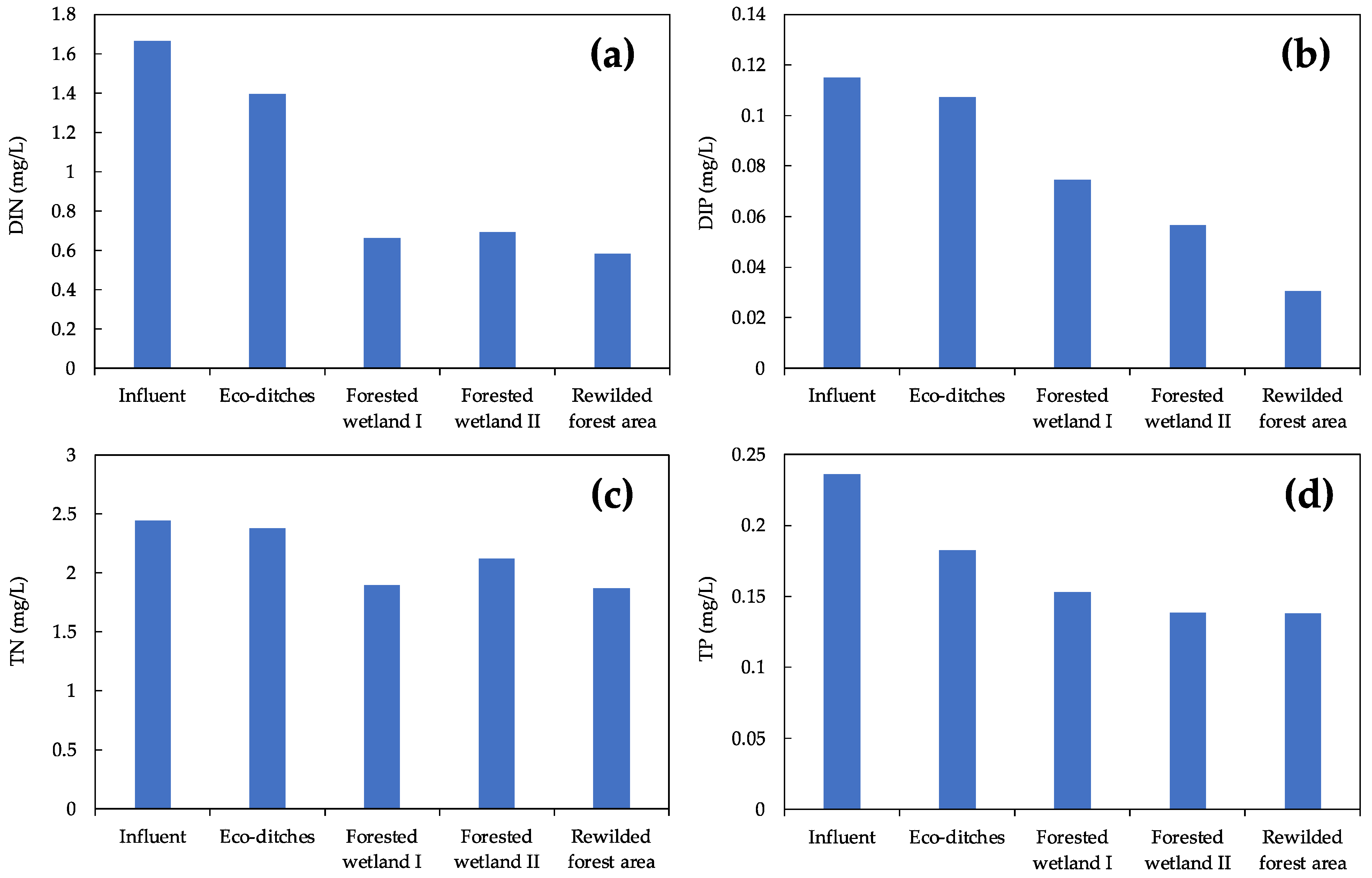
2.2.1. Water Quality

In 2022, water-quality monitoring was carried out seasonally, with additional monthly sampling during the main cropping period (June–October). Flow direction within the forested wetland and the sampling locations are shown in Figure 2. Water samples were collected at a depth of 20 cm below the surface without disturbing the sediment. The procedures for sample collection and analysis followed the standard methods [9]. Chlorophyll-a concentrations were measured using a Phyto-PAM II fluorometer (Walz, Effeltrich, Germany).

2.2.2. Bird Survey

In 2022, eight bird surveys were carried out across the four seasons in the 11.6 ha forested wetland habitat and in an adjacent woodland/farm habitat of almost the same area (locations shown in Figure 3). The survey utilized the transect and point-count methods. A transect of approximately 1.9 km long was established within each habitat, and both transects were surveyed twice. Surveys were conducted on clear weekday mornings when wind speeds did not exceed level 4, beginning one hour after sunrise and ending no later than three hours after sunrise. Binoculars and long-focus cameras were used to observe and photograph birds along the transects, recording their species, abundance, and habitat information. Bird identification was according to the Field Guide to the Birds of China and the Checklist of the Classification and Distribution of Birds in China.

3. Results

3.1. The Agricultural Runoff Treatment and Flood Control

Table 1 shows the concentrations of nitrogen and phosphorus in the influent (runoff from farmland) and effluent of the forested wetland in 2022. The average concentrations of NH4-N, NO3-N, dissolved inorganic nitrogen and phosphorus (DIN and DIP), and total nitrogen and phosphorus (TN and TP) in the influent were 0.31 mg/L, 1.22 mg/L, 1.66 mg/L, 0.12 mg/L, 2.44 mg/L, and 0.24 mg/L, respectively. After treatment by the forested wetland, their concentrations decreased to 0.16 mg/L, 0.36 mg/L, 0.58 mg/L, 0.03 mg/L, 1.87 mg/L, and 0.14 mg/L, with the average removal rates reaching 49%, 71%, 65%, 74%, 23%, and 41%, respectively. The forested wetland was designed with a daily treatment capacity of 500 m3 and covered an area of 8240 m2. According to the results, the wetland achieved nitrogen and phosphorus removal rates of 9.0 mg/(m2·d) for ammonium nitrogen (NH4-N), 65.6 mg/(m2·d) for DIN, and 5.1 mg/(m2·d) for DIP. The results suggested that the forested wetland effectively removed nitrogen and phosphorus, significantly improving the water quality of agricultural runoff.
The monitoring results showed a general downstream decline in both nitrogen and phosphorus concentrations across the forested wetland in 2022 (Figure 4). For DIN, Forested Wetland I exhibited the highest removal efficiency, reducing DIN concentrations by 44%, followed by Eco-ditches, which achieved a 16% reduction. In contrast, a slight increase in DIN levels was observed after flow passed through Forested Wetland II. In terms of TN, Forested Wetland I again showed the strongest removal capacity, accounting for a 20% reduction. The Rewilded Forest Area contributed an additional 10% reduction, whereas TN concentrations increased after water flowed through Forested Wetland II. Phosphorus concentrations showed a continuous decline from the influent to the Rewilded Forest Area. For DIP, Forested Wetland I and the Rewilded Forest Area were the most effective units, reducing DIP concentrations by 28% and 23%, respectively. Forested Wetland II achieved a 16% reduction, while Eco-ditches contributed a limited 7% reduction. Regarding TP, Eco-ditches exhibited the highest removal capacity, reducing TP concentrations by 23%, followed by Forested Wetland I and Forested Wetland II, with reductions of 13% and 6%, respectively. TP concentrations remained relatively stable after passing through the Rewilded Forest Area. The combined performance of the different units highlights the importance of integrating diverse function types to enhance overall nutrient removal in constructed wetlands.
The flood control capacity of GTI was related to its land use. Before the establishment of GTI, the site comprised 9.28 hm2 of grassland and 4.19 hm2 of woodland. After GTI was established, the land use was converted to 9.28 hm2 of paddy fields, 2.07 hm2 of woodland, and 2.12 hm2 of forested wetland. According to previous studies, the R values (the efficiency coefficient of the ecosystem in reducing runoff compared with bare land) for grassland, woodland, forested wetland, and paddy fields were 0.17, 0.26, 0.40, and 0.20, respectively [10]. Therefore, before the establishment of GTI, the flood control capacity of the area was approximately 2048 m3. In contrast, after the establishment of GTI, this value increased to approximately 2490 m3, suggesting a significant enhancement in flood control capacity. That is mainly because after the grassland was converted to paddy fields, the flood control capacity increased by about 22%, and this increase was further enhanced by converting woodland to forested wetland.

3.2. The Bird Attraction

The 2022 bird survey recorded 455 individuals representing 46 species, 30 families, and 12 orders. Passeriformes (perching birds) exhibited the highest species richness, with 30 species from 19 families, accounting for 65% of the recorded species. In terms of conservation status, the survey identified several nationally significant species, including Buteo japonicus and Falco tinnunculus, both of which are classified as Second-Class National Protected Species. Furthermore, Emberiza rustica was listed as Vulnerable (VU) on the IUCN Red List of Threatened Species. Based on ecological classification, 35 species were forest-dwelling birds, including 30 songbirds, 2 raptors, and 3 woodpeckers. A total of eight species were waterbirds, including seven waders and one swimmer. Songbirds and waders are the most abundant, accounting for 65% and 15% of the total species, respectively. Additionally, three terrestrial bird species were recorded.
A comparison of bird survey data between GTI (forested wetland habitats) and the nearby woodland/farm habitat revealed that creating diverse habitat types can attract a wider variety of bird species (Table 2). In 2022, 45.8% of the total bird species were observed in both habitats. The proportion of species and number of birds recorded only in GTI reached 50.0% and 23.1%, respectively, significantly surpassing the bird species and number proportions observed only in near forest/farm habitats. For example, 24 species of birds, including Actitis hypoleucos, Eophona migratoria, Alcedo atthis, Buteo japonicus, Phylloscopus proregulus, Phasianus colchicus, and Ardea cinerea, were only observed in GTI. In contrast, only two species, Phylloscopus inornatus and Lonchura punctulata, were observed in the nearby forest/farm habitat. Moreover, the Shannon biodiversity index (H′) was 3.253 in the forested wetland habitat and 2.800 in the woodland/farm habitat. These results highlight the role of GTI in providing suitable habitats for birds and enhancing the area’s capacity to attract a diverse range of bird species.

3.3. Other Critical Services Provided by Green Treasure Island
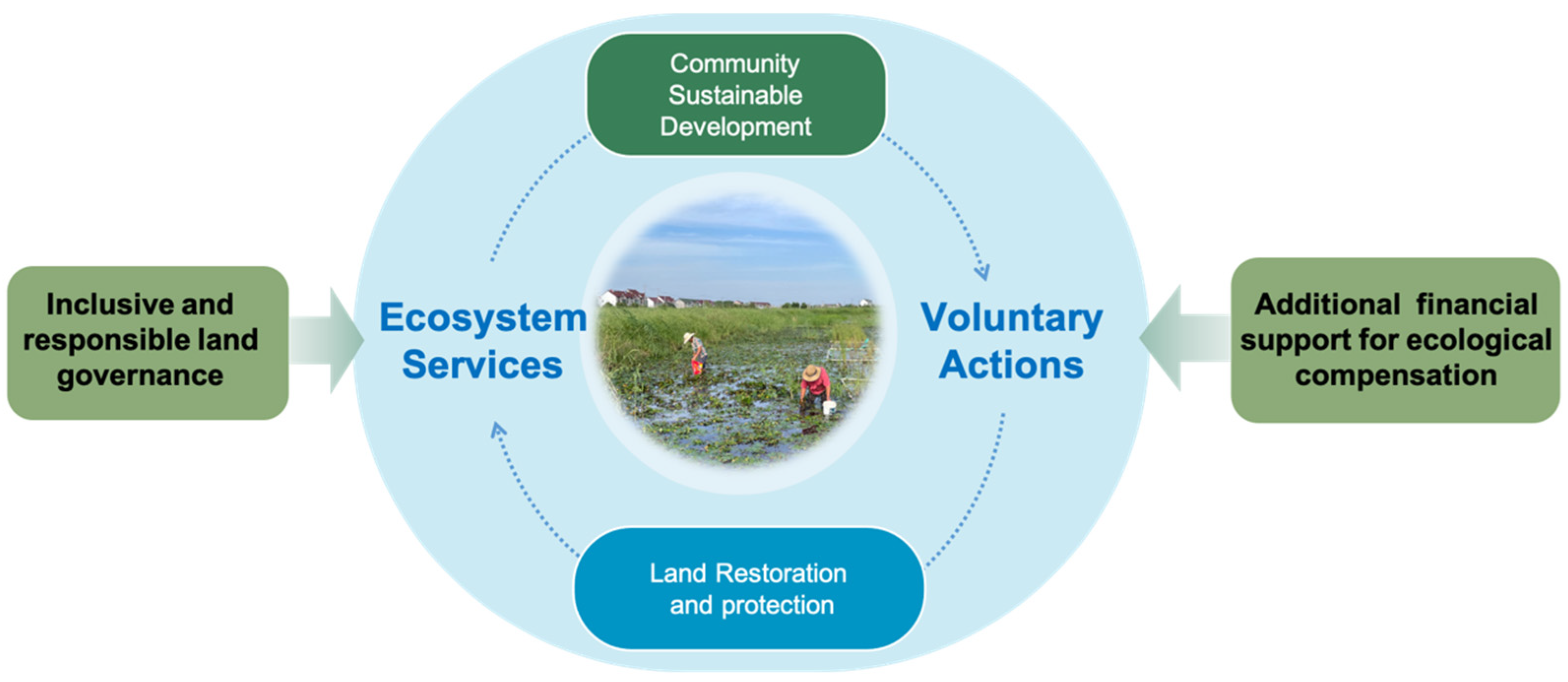
GTI expanded 9.28 hm2 of farmland through land consolidation, thereby enhancing the overall agricultural production capacity of the local region. According to the Jinshan District Statistical Yearbook [11], in 2022, the local yield of paddy fields was 8.25 tons/hm2, with a unit area output value of 27,644.7 CNY/hm2. As a result, the output of the 9.28 hm2 paddy fields within GTI amounted to 76.56 tons, equivalent to an annual output value of CNY 256,500. With the enhancement of ecological functions, GTI emerged as a biodiversity hotspot, serving not only as an ecological backyard for local community residents but also as a biophilic recreational space for urban residents. Through nature education activities, the biodiversity beauty within GTI was showcased, serving as a way to address the nature deficit disorder of urban residents. In 2022, approximately 20 nature education activities of various types were organized, with an average of 60 participants per activity, attracting around 1200 visitors to GTI. Additionally, a large number of tourists visited the restoration site. Given that GTI is located in Langxia Countryside Park, the number of tourists here is conservatively estimated at approximately 0.5% of the total number of park visitors, equating to about 3400 in 2022. According to our survey [12], approximately 64.8% of the tourists visiting Langxia Countryside Park were residents of Jinshan District, while 35.2% were from other districts. Previous studies have suggested that the recreational value for residents was about CNY 20 per person, while that for tourists from outside the area was about CNY 50 per person [13]. Therefore, it was estimated that GTI could generate at least CNY 103,900 in potential leisure and entertainment value p annually. Moreover, as GTI attracted visits from thousands of urban residents, it not only generated more green jobs but also promoted the sales of local green agricultural products, which indirectly benefited the local rural residents.

4. Discussion

Metropolitan rural areas are usually positioned as subordinate to urban areas, undertaking the main function of supplying agricultural products. Previous studies suggested that rural areas should prioritize biodiversity conservation and land restoration, thereby maintaining ecological spaces that provide essential services for all citizens [14]. However, intensive rice cultivation in rural areas has given rise to ecological and environmental challenges, resulting in a deterioration in water quality and a decline in ecosystem services. The integrated utilization of ecosystems emphasizes the promotion of synergistic effects among various functions through regulating the internal structure and functions of the ecosystems [15]. This approach has proven to be an effective strategy for addressing the ecological and environmental issues of farmland while comprehensively enhancing water quality and ecosystem services. For instance, Rossert et al. [16] proposed a regulated coupling approach that includes reducing chemical inputs (e.g., pesticides, fertilizers), implementing rotary tillage, and strategically allocating crop acreage to achieve a balance between economic benefits and ecosystem conservation. Based on the assumption of net primary productivity (NPP) trade-offs, Xu et al. [17] proposed that allocating natural grassland for establishing artificial pasture could concurrently enhance livestock carrying capacity, air purification function, and carbon sequestration. Our GTI practice demonstrates that integrating wetland, forestry, and agriculture spaces can yield multifaceted synergies. Specifically, along with agricultural development, the created forested wetland assists the local community in purifying agricultural runoff and regulating floods, provides diverse habitats for wildlife, and functions as an accessible natural park for both rural and urban residents, thereby achieving an efficient, equitable, and sustainable enhancement of ecosystem service value [18].
We implemented several novel strategies to ensure that GTI operates effectively and provides ecosystem services sustainably. First, the landscape structure of GTI was optimized through comprehensive investigations, systematic analysis, and optimal design. Regional land planning prioritized ecosystem protection, and new development was balanced with restoration efforts to mitigate land degradation and enhance biodiversity. Land-use analysis and ecological monitoring were conducted to identify the priority greenfield areas for protection. The changes in hydrology, soil, and the ecosystem in the developing region were assessed, and an ecological restoration toolkit was developed for implementation. Notably, an innovative forested wetland system was established, emerging as the pivotal ecological functional zone of GTI. Forested wetlands integrate the water purification role of conventional constructed wetlands with the biological conservation value of forestry. In addition, forested wetlands retain floodwater, accumulate large soil organic carbon stores, and create diverse habitats that boost biodiversity, while offering growing cultural and recreational benefits for people. Furthermore, they effectively mitigate the ecological impacts of land consolidation. Typical constructed wetlands depend on dense stands of emergent plants for purification. Compared with conventional restoration models, the GTI forested wetland shows competitive treatment efficiency and enhanced multifunctional use. Under an HRT of 6.6 d, the GTI forested wetland removed 65% of DIN and 74% of DIP from agricultural runoff, which is comparable to the treatment capacity of conventional constructed wetland systems. By contrast, the 1470 ha Cypriere Perdue forested wetland in Louisiana (USA) treats 3785 m3/d of secondary effluent (2.6 m3/(ha × d)) [19], whereas GTI handles 500 m3/d on only 7 ha (71 m3/(ha × d)), a 30-fold higher hydraulic loading that highlights its nutrient removal and land-use efficiency. Bird surveys showed a similar pattern. The 27 ha Hsin-Hai II and 50 ha Daniaopi wetlands each host 45–50 bird species per year [20], whereas the 7 ha GTI attracted 46 species in 2022, yielding a much higher species density.
Second, an incentive policy was introduced to promote the reconversion of greyfields to greenfields in rural areas. Land credits are created from greyfield land reduction, and they can be deposited into the land account and further converted to funds for ecological restoration and public space construction in rural areas. Inefficiently used industrial and storage land in rural areas was reduced to obtain land credits, which were then deposited into the land account. The revenues from this account were invested in creating GTI and upgrading public space for nature education and community activities.
Third, the government has sponsored several initiatives aimed at protecting GTI and preserving rural intangible cultural heritage. Alongside ecological restoration and the enhancement of public spaces, community infrastructure—including roads and parking lots—has been upgraded, and tourist service centers and guideboards have been installed to improve accessibility and enrich the recreational experiences of urban visitors. Current research indicates that the realization of ecological product values can play a significant role in promoting urban–rural integration [21]. This study further reveals that strengthening the connection between urban and rural areas can also enhance the value of ecosystem services and ecological products. As one of the key platforms for this transformation, GTI has evolved into a shared natural and cultural asset, benefiting both rural communities and urban residents alike.
From an economic perspective, GTI is also competitive with conventional constructed wetlands. GTI repurposed existing woodland and disused ponds, thereby avoiding most earth-moving, filter-media placement, and pipework; the only notable extra cost was the planting of cypress trees in wetlands. Therefore, total construction expenditure was comparable to that of conventional constructed wetlands. For the operating costs, vegetation management is covered by local ecological forest subsidies, and intermittent pumping consumes roughly the same electricity as a conventional constructed wetland. On the benefit side, enhanced rice yield, visitor spending, and nature education activities will offset operating costs within a few years. However, GTI’s long-term viability depends on steady subsidies and stable visitor demand; a drop in either could negatively affect its income. To safeguard income, actions that should be considered include installing solar-powered pumps, diversifying agritourism products, and establishing a community fund that reinvests part of the income in wetland maintenance. With these measures, diversified incomes, together with low maintenance demand, should keep GTI cash-positive, indicating that the model is economically sustainable and replicable.
Although ecosystem services have been significantly enhanced and ecological value has been partially realized in this practice, it is worth noting that ensuring the sustainability of this process is crucial [22]. This requires the joint efforts of all stakeholders to protect the newly restored ecosystem and facilitate the realization of ecological product values (Figure 5). The government sponsored some projects to support the joint efforts of experts, volunteers, enterprises, and the local community in protecting GTI. Youth from urban areas were attracted by the beautiful scenes of Youhao Village and were willing to contribute positively to rural governance. Volunteers organized nature education courses and culture-experiencing activities to highlight the social value of GTI and promoted the sale of local green agricultural products. GTI was recorded in terms of news and documentaries to raise public awareness. Through adaptive management and the support of nature education activities, GTI has progressively emerged as a landmark that embodies the unique natural–social characteristics of the region. It serves as a “magnet”, bridging the gap between urban and rural residents and fostering the flow of external resources back into rural communities. As the importance of GTI was appreciated by both urban and rural residents, a social consensus on its conservation was formed, thereby enabling its sustainable utilization. Consequently, this enhanced the capacity to transform ecological value and achieve the sustainability of ecological protection and restoration efforts.
On the other hand, to ensure sustainability and increase the value of GTI, it is crucial to adopt a management approach that balances biodiversity conservation with recreational needs. This endeavor necessitates not only financial allocations but also the participation of skilled technical teams. Taking the case of Youhao Village as an example, GTI serves as an ecological asset collectively owned by the village. Its farmland generates continuous income, while forested wetlands, designated as ecological conservation forests, are eligible for government-funded management and ecological compensation. These funding sources are sufficient to support the regular operation of GTI. Moreover, surrounding infrastructure can be repurposed to provide supporting services [23,24,25]. By introducing a third-party operator with strong technical expertise, the ecological asset of GTI could achieve sustained value appreciation, creating a win–win scenario for conservation and community development.
Despite its benefits, the GTI model also faces several risks that must be considered before wider application. Unlike conventional parks or lawns, GTI does not require routine mowing; however, invasive plants still need targeted attention. During the process of natural revegetation, invasive species have been recorded, such as Erigeron sumatrensis, Symphyotrichum subulatum, and Solidago canadensis, whose rapid growth and allelopathic effects could suppress native plants and alter habitat structure. Herbicides should be avoided wherever possible, and regular manual weeding, carried out by hired local residents, offers a low-impact, community-beneficial control strategy. Hydrologically, agricultural runoff enters the wetland by gravity overflow during the cropping season, but dry-season water levels depend on pumped river inflow, increasing energy and maintenance costs. Moreover, in this study, the flood control capacity estimate was based on theoretical runoff reduction efficiency coefficients and lacked field validation and error estimation. Future investigation will apply pump-controlled rainfall simulations to measure the flood control capacity of the wetland directly, and canopy interception by wetland vegetation will also be considered to estimate the error. Land-use regulations also differ among regions, and shifting policy conditions could challenge the operation of the GTI model. Therefore, long-term funding and adaptive management are essential to GTI’s successful replication.
In summary, the core of GTI lies in establishing a closed-loop system for sustainable land restoration, which requires inclusive and responsible land governance, external financial support, and intellectual contributions from scientific and technological personnel. More importantly, residents have become the direct beneficiaries of land restoration and conservation, thus taking the initiative to participate in ecological restoration and sustainable land management activities, playing a key role. In the future, the “Ecological Asset-Real Estate Investment Trusts” (Eco Asset-REITs) mechanism can be explored. A GTI investment trust fund could be created by accurately accounting ecological asset value, incorporating forest land management funds, ecological compensation funds, and ecosystem services. Once the management costs and returns of GTI are monetized, GTI will attract urban investors to cooperate with residents in long-term land management, forming an innovative mechanism for urban–rural co-cultivation of ecological assets.

5. Conclusions

In this study, we introduced a nature-based, people-centered approach to sustainable land restoration by establishing “Green Treasure Island” (GTI) in Youhao Village, Shanghai. This integrated framework combines land consolidation, water purification ecological restoration, and sustainable land use. The 7 hm2 forested wetland effectively reduced nitrogen and phosphorus levels in agricultural runoff, with removal rates of 65% for DIN and 74% for DIP. The area’s flood control capacity improved by approximately 22%. Land consolidation expanded farmland by 9.28 hm2, resulting in an annual rice yield of about 76.56 tons. GTI also enhanced bird biodiversity, attracting 48 bird species, including nationally protected ones. Furthermore, it served as a recreational space and hosted nature education activities. These ecological and social benefits promoted local green jobs and the sales of local green agricultural products, indirectly benefiting the local rural residents. Through adaptive management and educational initiatives, GTI has become a landmark reflecting the region’s unique natural and social characteristics, accessible to both rural and urban residents. This study demonstrates GTI’s feasibility and proposes key strategies for sustainable land restoration, providing a basis for broader application. Future studies should implement multi-year ecological monitoring and socio-economic surveys to evaluate GTI‘s long-term performance and climate resilience. Moreover, cost–benefit and life-cycle assessments will help improve management, guide fund utilization, and quantify ecosystem service value. These efforts will support the wider replication of the GTI model in metropolitan rural areas under different climates and policies.

Author Contributions

Conceptualization, Z.H. and Y.H.; formal analysis, Z.H. and Y.S.; investigation, R.S. and K.H.; methodology, Z.H. and Y.S.; supervision, Y.H.; writing—original draft, Z.H. and Y.S.; writing—review and editing, Y.S., T.W., Y.H. and X.C. All authors have read and agreed to the published version of the manuscript.

Funding

This research was funded by the Science and Technology Commission of Shanghai Municipality, grant number 22dz1202600.

Data Availability Statement

The data presented in this study are available on request from the corresponding author.

Conflicts of Interest

The authors declare no conflicts of interest.

References

  1. Irwin, E.G.; Bockstael, N.E. The evolution of urban sprawl: Evidence of spatial heterogeneity and increasing land fragmentation. Proc. Natl. Acad. Sci. USA 2007, 104, 20672–20677. [Google Scholar] [CrossRef] [PubMed]
  2. Johnson, M.P. Environmental impacts of urban sprawl: A survey of the literature and proposed research agenda. Environ. Plan. A Econ. Space 2001, 33, 717–735. [Google Scholar] [CrossRef]
  3. Su, S.L.; Jiang, Z.L.; Zhang, Q.; Zhang, Y.A. Transformation of agricultural landscapes under rapid urbanization: A threat to sustainability in Hang-Jia-Hu region, China. Appl. Geogr. 2011, 31, 439–449. [Google Scholar] [CrossRef]
  4. Reis, B.P.; Branquinho, C.; Torok, K.; Rehounková, K.; Nunes, A.; Halassy, M. The added value of the long-term ecological research network to upscale restoration in Europe. J. Environ. Manag. 2024, 366, 121736. [Google Scholar] [CrossRef]
  5. Vymazal, J. Constructed Wetlands for Wastewater Treatment. Water 2010, 2, 530–549. [Google Scholar] [CrossRef]
  6. Garcia-Polo, J.; Falkowski, T.B.; Mokashi, S.A.; Law, E.P.; Fix, A.J.; Diemont, S.A.W. Restoring ecosystems and eating them too: Guidance from agroecology for sustainability. Restor. Ecol. 2021, 29, e13509. [Google Scholar] [CrossRef]
  7. Middleton, B.A. Soil seed banks and the potential restoration of forested wetlands after farming. J. Appl. Ecol. 2023, 40, 1025–1034. [Google Scholar] [CrossRef]
  8. Smith, C.S.; DeMattia, E.A.; Albright, E.; Bromberger, A.F.; Hayward, O.G.; Mackinson, I.J.; Mantell, S.A.; McAdoo, B.G.; McAfee, D.; McCollum, A.; et al. Beyond despair: Leveraging ecosystem restoration for psychosocial resilience. Proc. Natl. Acad. Sci. USA 2025, 122, e2307082121. [Google Scholar] [CrossRef]
  9. American Public Health Association. Standard Methods for the Examination of Water and Wastewater, 19th ed.; American Public Health Association Inc.: Washington, DC, USA, 1995. [Google Scholar]
  10. Zhang, X.Y.; Ma, W.Y.; He, W.J.; Sheng, S.H. Spatial and temporal evolution of ecosystem services in the Three Gorges Reservoir area of Chongqing. Ecol. Econ. 2023, 39, 145–155. (In Chinese) [Google Scholar]
  11. Jinshan District Bureau of Statistics, Shanghai Municipality. Statistical Yearbook of Jinshan District, Shanghai; Jinshan District Bureau of Statistics: Shanghai, China, 2021. [Google Scholar]
  12. Pan, L.P.; Liu, L.F. Dynamic Monitoring and Evaluation of Construction Effectiveness of Country Parks in Shanghai Supported by Big Data. Urban Rural. Plan. 2018, 5, 47–56. (In Chinese) [Google Scholar]
  13. Wu, W.; Li, C.X.; Chen, X.C. Evaluation of the effectiveness of a coastal ecological restoration project based on ecosystem services: A case study on Yingwuzhou Wetland, China. J. East China Norm. Univ. Nat. Sci. 2020, 2020, 98–108. (In Chinese) [Google Scholar]
  14. Dawson, N.M.; Coolsaet, B.; Sterling, E.J.; Loveridge, R.; Gross-Camp, N.D.; Wongbusarakum, S.; Sangha, K.K.; Scherl, L.M.; Phan, H.P.; Zafra-Calvo, N.; et al. The role of Indigenous peoples and local communities in effective and equitable conservation. Ecol. Soc. 2021, 26, 19. [Google Scholar] [CrossRef]
  15. Gu, X.K.; Xu, D.Y.; Xu, M.Y.; Zhang, Z.F. Measuring residents’ perceptions of multifunctional land use in peri-urban areas of three Chinese megacities: Suggestions for governance from a demand perspective. Cities 2022, 126, 103703. [Google Scholar] [CrossRef]
  16. Roessert, S.; Gosling, E.; Gandorfer, M.; Knoke, T. Woodchips or potato chips? How enhancing soil carbon and reducing chemical inputs influence the allocation of cropland. Agric. Syst. 2022, 198, 103372. [Google Scholar] [CrossRef]
  17. Xu, K.; Wang, H.; Li, X.; Liu, H.; Chi, D.; Yu, F. Identifying areas suitable for cultivation of Medicago sativa L. in a typical steppe of Inner Mongolia. Environ. Earth Sci. 2016, 75, 341. [Google Scholar] [CrossRef]
  18. Costanza, R. Valuing natural capital and ecosystem services toward the goals of efficiency, fairness, and sustainability. Ecosyst. Serv. 2020, 43, 101096. [Google Scholar] [CrossRef]
  19. Hunter, R.; Lane, R.; Day, J.; Lindsey, J.; Day, J.; Hunter, M. Nutrient Removal and Loading Rate Analysis of Louisiana Forested Wetlands Assimilating Treated Municipal Effluent. Environ. Manag. 2009, 44, 865–873. [Google Scholar] [CrossRef]
  20. Hsu, C.B.; Hsieh, H.L.; Yang, L.; Wu, S.H.; Chang, J.S.; Hsiao, S.C.; Su, H.C.; Yeh, C.H.; Ho, Y.S.; Lin, H.J. Biodiversity of constructed wetlands for wastewater treatment. Ecol. Eng. 2011, 37, 1533–1545. [Google Scholar] [CrossRef]
  21. Constant, N.L.; Taylor, P.J. Restoring the forest revives our culture: Ecosystem services and values for ecological restoration across the rural-urban nexus in South Africa. For. Policy Econ. 2020, 118, 102222. [Google Scholar] [CrossRef]
  22. Elias, M.; Kandel, M.; Mansourian, S.; Meinzen-Dick, R.; Crossland, M.; Joshi, D.; Kariuki, J.; Lee, L.C.; McElwee, P.; Sen, A.; et al. Ten people-centered rules for socially sustainable ecosystem restoration. Restor. Ecol. 2022, 30, e13574. [Google Scholar] [CrossRef]
  23. Cao, R.; Wang, J.Y.; Tian, X.; Zou, Y.C.; Jiang, M.; Yu, H.; Zhao, C.L.; Zhou, X.R. Post-restoration monitoring of wetland restored from farmland indicated that its effectiveness barely measured up. Water 2024, 16, 410. [Google Scholar] [CrossRef]
  24. England, J.; Angelopoulos, N.; Cooksley, S.; Dodd, J.; Gill, A.; Gilvear, D.; Johnson, M.; Naura, M.; O’hare, M.; Tree, A.; et al. Best practices for monitoring and assessing the ecological response to river restoration. Water 2021, 13, 3352. [Google Scholar] [CrossRef]
  25. Wang, Y.; LI, Y. Evaluation of ecosystem protection and restoration effects based on the mountain-river-forest-field-lake-grass community concept: A case study of the Hunjiang River Basin in Jilin Province, China. Water 2024, 16, 2239. [Google Scholar] [CrossRef]
Figure 1. The design of Green Treasure Island. Blue arrows indicate agricultural runoffs, and white arrows indicate influent and effluent of the Green Treasure Island.
Water 17 01682 g001
Figure 2. Water flow direction in the forested wetland and the sampling sites.
Water 17 01682 g002
Figure 3. Bird survey areas.
Water 17 01682 g003
Figure 4. The variation in nitrogen and phosphorus concentrations along four eco-functional units of the forested wetland.
Water 17 01682 g004
Figure 5. The joint efforts of stakeholders to implement land restoration and protection.
Water 17 01682 g005
Table 1. The concentrations of nitrogen and phosphorus in the influent and effluent of the forested wetland in 2022.
IndicatorNH4-NNO3-NDINDIPTNTP
Influent
(mg/L)
0.31
(0.03~0.80)
1.22
(0.39~2.85)
1.66
(0.063~2.95)
0.12
(0.02~0.45)
2.44
(1.04~6.53)
0.24
(0.10~0.60)
Effluent
(mg/L)
0.16
(0.02~0.39)
0.36
(0.16~0.50)
0.58
(0.34~1.00)
0.03
(0.01~0.14)
1.87
(0.84~3.92)
0.14
(0.07~0.32)
Removal rate
mg/(m2·d)
9.052.265.65.134.85.9
Table 2. Difference in bird species in forested wetland habitat and woodland/farm habitat.
Only in One Single HabitatIn Both Habitats
Forested Wetland HabitatWoodland/Farm Habitat
Number of species24222
Proportion of total species50.0%4.2%45.8%
Abundance12815411
Proportion of total abundance23.1%2.7%74.2%
Disclaimer/Publisher’s Note: The statements, opinions and data contained in all publications are solely those of the individual author(s) and contributor(s) and not of MDPI and/or the editor(s). MDPI and/or the editor(s) disclaim responsibility for any injury to people or property resulting from any ideas, methods, instructions or products referred to in the content.

