Article

New Insights About the Drivers of Change in the Coastal Wetlands of Peru: Results of a Rapid Field Survey

by
Héctor Aponte
*,
Maria-Paula Coello-Sarmiento
and
David Montes-Iturrizaga
Carrera de Biología Marina, Facultad de Ciencias Veterinarias y Biológicas, Universidad Científica del Sur, Lima 15842, Peru
*
Author to whom correspondence should be addressed.
Water 2025, 17(10), 1473; https://doi.org/10.3390/w17101473
Submission received: 14 April 2025 / Revised: 10 May 2025 / Accepted: 12 May 2025 / Published: 14 May 2025
(This article belongs to the Special Issue Impacts of Climate Change & Human Activities on Wetland Ecosystems)

Abstract

:
Wetlands are essential ecosystems that provide numerous services that are critical for human survival on a global scale. In Peru, these vital areas are situated along the coastal desert, one of the most densely populated regions in the country. This study employed a rapid field survey methodology to investigate the drivers of change (DOC) in 11 poorly studied wetlands along the Peruvian coast. Field visits occurred from August 2023 to August 2024, during which the DOC identified were documented. We performed similarity analyses of the data to identify (a) locations requiring similar management approaches and (b) co-occurring DOC. Our research identified 16 DOC; the presence of debris and waste, as well as roads or pathways that provide vehicular access, were the most frequent, followed by livestock and fisheries. The similarity analysis highlighted the crucial role of accessibility to these wetlands, as this increases the risk of adverse effects, whether from waste dumping or livestock. The findings suggest that several river mouths exhibit similar drivers, underscoring the need for coordinated management strategies.

Graphical Abstract

1. Introduction

Wetlands are aquatic ecosystems that hold great value for humans. When properly conserved, they promote health and offer multiple economic benefits, while also supporting the livelihoods of thousands of species [1,2,3]. Despite this, the world’s wetlands face a series of threats, largely stemming from anthropogenic activities. In some world regions, more than 50% of these ecosystems have been destroyed due to land conversion for agriculture, urban expansion, and industrial activities [4,5,6]. Additionally, the dumping of waste, the effects of climate change, and various pollution processes led to the deterioration of many of these ecosystems [7,8,9]. This underscores the importance of studying and protecting these ecosystems to preserve their essential services.
Among the wide variety of wetlands, coastal wetlands are unique due to the hydrological processes they regulate (linking marine and continental environments) as well as the vast diversity they support [10]. This led to their ecosystem services being valued at billions of dollars each year, with carbon sequestration being one of the most important [11,12]. Unfortunately, in several countries, 70% to 80% of these ecosystems have been destroyed [10]; aside from their conservation status, these coastal ecosystems are known to have various impacts, primarily driven by habitat loss, alterations in connectivity, and pollution, which are the main pressures affecting these environments globally (refer to [13] for a comprehensive literature review on this topic). In South America, wetlands confront specific challenges that threaten their integrity; for example, the intensification of El Niño–Southern Oscillation affects the Pacific region, causing serious imbalances in the hydrological cycle [14]. This situation jeopardizes the diversity of species that inhabit these areas and, consequently, the provision of essential ecosystem services, such as storm protection, access to clean water, and the regulation of critical biogeochemical cycles, such as carbon [15].
On the Peruvian coast, the reality is no different. The assessment of the diversity of its wetlands highlights how valuable these ecosystems are as habitats for mammals [16], birds [17], vascular flora [18], invertebrates [19], and herpetofauna [20], among other groups of organisms. However, recent studies indicate that some of these wetlands have been deteriorating and shrinking even if protected [21]. Drivers of change (DOC), such as the presence of debris and waste, the introduction of non-native species, and ongoing pressure for land use transformation for agricultural purposes, have been identified as significant issues in this country [22]. Additionally, scientific information is unevenly distributed, being concentrated in the capital (Lima) and at specific wetlands, including Los Pantanos de Villa and Los Manglares de Tumbes [23]. This situation highlights the crucial need to comprehend the activities in under-studied wetlands to the north and south of Peru’s central coast, which will help to identify various processes that may be affecting them early on.
In this context, this research aimed to determine the DOC in 11 poorly studied or non-studied coastal wetlands along the Peruvian coast. This unprecedented effort facilitated the identification of the challenges associated with conserving these ecosystems. Given that the primary objective of this research was to identify the DOC in the evaluated locations, the initial hypothesis suggests that we would discover new DOC compared to those documented in the literature for the other studied wetlands of Peru.

2. Materials and Methods
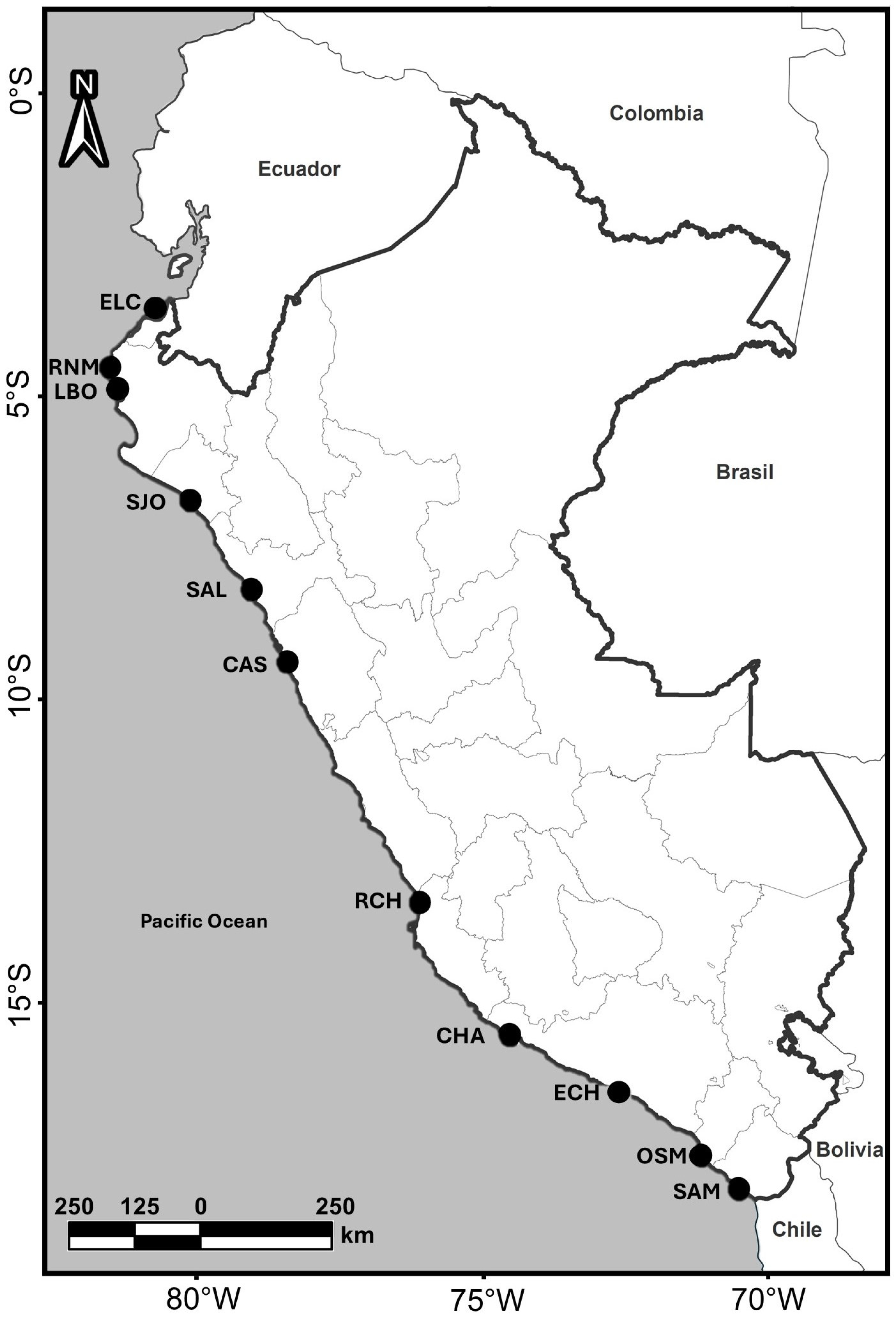
2.1. Study Area

Eleven coastal wetlands, situated between 3° and 18° South latitude, were studied (Figure 1). These wetlands were selected to ensure accessibility during the study period, maintain safety for field activities, and confirm that they were minimally or not previously studied wetlands along the Peruvian coast, following the recommendations of [23]. Each ecosystem possesses its own structural characteristics; mangroves transitioning to dry forest, river mouths, and coastal lagoons were assessed, each exhibiting different vegetation characteristics (Table 1).

2.2. Field Monitoring

Three field expeditions were conducted in August 2023, February 2024, and August 2024. These months were chosen because they represent the warm and winter seasons in the region. Each wetland was explored during each voyage, considering access conditions; the polygons representing the assessed area are included in Supplementary Material S1. During each visit, the DOC that could be observed were noted based on [24], which includes a list of DOC for some previously studied Peruvian coastal wetlands. This list also included a section called “others”, which allowed the recording of any other DOC not recorded in the preliminary list. Whenever possible, DOC were photographed (in the case of human presence, permission was sought from the individuals, and photographs were only taken if this permission was granted). For the registration of roads and highways, images available on Google Earth were also used. The presence of solid waste was recorded in the “accumulation of debris or trash” category, the presence of livestock feces in the “livestock and grazing” category, and the presence of pipes or canals carrying water from agricultural fields that suggested some type of contamination was recorded in the “wastewater” category. For the “accumulation of debris or trash” category, the following items were noted: a few scattered items, one or a few accumulations in the wetland, or many accumulations found throughout the assessed area. For “exotic species,” the presence of stray dogs was noted (photographs were taken whenever possible); the presence of Tamarix aphylla was taken from the species list generated by the BioHCosp project, which is included in the Atlas of Wetlands of the South American Pacific, and where the same localities were assessed over the same period of time (accessible at this link https://humedalescosteros.org/atlas/ accessed on 1 April 2025). In the case of “industrial or artisanal fisheries”, the presence of artisanal fishers or ports was considered evidence. For “roads”, the presence of motorcycles or ATVs, paved or asphalt roads, cars or trucks observed, and any other rudimentary transportation (e.g., horse-powered) were all noted. Since this research was based on rapid qualitative identification, we had some limits during field survey, for example “chemical contamination”, “organic matter contamination”, or “microbiological contamination”, were not included, as this would have required a thorough analysis of the water bodies in each ecosystem; also, indirect DOC (e.g., climate change and governance) were not recorded since this methodology is not appropriate.

2.3. Data Analysis

The frequency of DOC was calculated, and the wetlands with the highest and lowest number of these drivers were identified. It was also noted whether these drivers were identified in one, two, or three expeditions. Similarity analyses were subsequently performed to (a) compare the evaluated sites and infer which wetlands required similar management actions and (b) analyze the co-occurrence or possible relationships of DOC in the wetlands studied. The presence of a DOC in a location was analyzed qualitatively; for this purpose, the categories “exotic species” and “others” were divided into subcategories to avoid combining species and/or different types of new DOC. The similarity analysis was performed using the Jaccard index, and dendrograms were constructed following the unweighted pair group method with arithmetic mean and calculating the cophenetic correlation coefficient (CCC, as an indicator of the quality of the representation of the graphs, it was considered representative if the coefficient was greater than 0.8—using similar criteria as [22]); these analyses were performed with the PAST software V.5.0.2 [25].

3. Results

Table 2 summarizes the results from the three expeditions conducted during this research. The Supplementary Material compiles photographic evidence collected in the field whenever possible; some of the most notable drivers are illustrated in Figure 2. A total of 16 DOCs were identified, with the most frequent being the accumulation of debris and/or trash, as well as the presence of roads. Both drivers were observed in the majority of the wetlands during the three expeditions. The least frequent driver was sport hunting (observed only in the El Chiflón Wetland). The incidence of debris and/or trash varied in intensity, with the highest incidence being in the San José Wetland. It is important to highlight the presence of exotic species (such as dogs and Tamarix aphylla) in more than half of the wetlands. Other detected DOC included oil extraction (found only in La Bocana), recreational use (notably at the mouths of the Chincha River and Osmore River), mineral extraction (observed only at the mouth of the Sama River), and river barrier construction (associated with the mouths of the Casma River, Chincha River, and Osmore River mouth), the latter causing significant changes over the study period (Figure 3).
The similarity analysis among wetlands, based on their DOC (Figure 4a), indicated a similarity of around 0.9 between the mouths of the Casma River and Chincha River. The aforementioned localities also exhibited a similarity above 0.68 with the San José Wetland. The similarity between the Reserva Natural Malaca and Salaverry Wetland (with values around 68%) was notable, as was the similarity between this group and La Bocana. All other values were below 50% of similarity. The CCC (>0.8) demonstrated that the dendrogram analyzed was reliable.
The similarity analysis of the DOC by wetland (Figure 4b) revealed a notable co-occurrence of roads, trash and/or land clearing, livestock and grazing, fisheries, and agriculture, all forming a cluster. Another cluster was formed by urbanization and fires. Sport hunting also formed a cluster with noise (with a 100% coincidence) and the presence of barriers with the occurrence of wastewater channels (with values above 0.6). All other values were below 50% of similarity. The CCC (>0.9) indicated that the dendrogram analyzed was reliable.

4. Discussion

This study determined that the most frequent DOC in the coastal wetlands studied were the accumulation of debris, the presence of roads and access routes (vehicle fleet), the incidence of livestock activities, and the occurrence of artisanal fishing activities. This is not unusual for the DOC on the Peruvian coast, since livestock farming and grazing, as well as the accumulation of debris or garbage, have previously been identified among the most frequent [22,24]. The frequency of these drivers in coastal wetlands could be related to urban development near water bodies. Since agriculture and livestock farming are vital activities that depend on water, human settlements occurred near water bodies [26], and in a desert coastal region such as Peru, this seems to be closely linked to wetlands. There are also coincidences between the results of this study and studies carried out on a larger scale; for example, agriculture has been identified globally as one of the main direct DOC in coastal wetlands [27], a scenario similar to [9], which described livestock farming as one of the most frequent drivers for Brazil and India. Some strategies include a multi-stakeholder approach to these DOC, with promising results in specific scenarios [28]. It is essential to evaluate these strategies, assess their effectiveness, and tailor them to the realities of the Peruvian coast.
The co-occurrence of some DOC in the wetlands studied could be linked to urban expansion and wetland accessibility. For example, wetlands with seven or more drivers (except El Chiflón Wetland and the mouth of the Osmore River, Table 2) showed both population growth/urbanization and roads. This shows the relationship that may exist between these two DOC: urbanization brings the need for access roads, which allow vehicles to reach the wetlands. Although all wetlands had formal or informal vehicle access, the combination with urbanization processes seems to generate a greater number of drivers. While this synergy is not immediately evident in the co-occurrence of DOC (Figure 4b), their potential consequences can be observed; for example, the dumping of waste rock and garbage is a possible consequence that also occurs in all wetlands (Table 2) and necessitates the construction of access roads. Wetlands with more restricted access, such as the Salaverry and Chaviña wetlands, showed less debris and litter. In Salaverry, the only road detected appeared to be used irregularly due to nearby port activities. This synergy has not been previously analyzed for Peruvian wetlands [22,24]; however, it is worthwhile to verify whether vehicular access to the wetland is a determining factor for the presence of litter and debris. It is imperative to explore in greater depth the potential implications associated with the existence of roads, as the deficiency in connectivity represents one of the most significant impacts previously identified on a global scale [13].
The accumulation of debris and litter was present in all the wetlands, on all three occasions, positioning it as one of the most worrisome drivers. As mentioned previously, this may be a consequence of urbanization, but also of irresponsible tourism activities. Until the 1990s, environmental legislation in Peru lacked solid waste management strategies; despite the advances made to date, there is currently only one law that sanctions this driver in Peruvian wetlands [29]. Although Peruvian legislation assigns the responsibility for solid waste management to the Ministry of Environment, municipalities, and residents (Legislative Decree 1278), it is essential to insist on promoting environmental education activities, which have been shown to significantly reduce bad practices (including littering) in Peruvian wetlands [30].
It is interesting to note that few DOC (≤5) were found in the Salaverry Wetland, Reserva Natural Malaca and the Chaviña Wetland, which include coastal lagoons and areas where there is an evident effort made towards their conservation (in all cases the signs and the commitment of local authorities to these ecosystems were evident). The latter suggests that one of the best strategies is the involvement of local authorities and the protection of these ecosystems. The declarations as a protected natural area, Ramsar site, or municipal conservation area are symbols of interest in their conservation which, despite requiring greater legal and coordination reinforcement [29], appear to reduce the number of negative DOC. Therefore, they could be strategies to strengthen the protection of these wetlands. Indeed, strong involvement of the population seems to be bearing fruit.
The similarity analysis revealed coincidences in the DOC identified for the river mouths (Casma River and Chincha River, and at a medium intensity between Humedal El Chiflón and the mouth of Osmore River) (Figure 4a). This suggests a detailed analysis of the drivers identified, monitoring their evolution, and proposing similar management strategies if necessary. For example, the construction of containment barriers at the mouth of the Casma River, the mouth of the Chincha River, and the mouth of the Osmore River significantly impacted the vegetation of these wetlands (Figure 3). While this construction is necessary to address river flooding, it is important to consider that these spaces are intangible (according to Supreme Decree DS 012-94-AG); consequently, there should be no construction in their vicinity. With the increasing effects of climate change, it will be important to have coastal ecosystems that help mitigate its impacts. Therefore, nature-based solution strategies could enable the use of wetlands to control flooding caused by river flooding [31]. These solutions should be considered and evaluated in future interventions. It is worth mentioning that few studies have been conducted in Peruvian river mouths [23], which suggests the need to maintain and increase efforts to understand their problems and socio-ecological dynamics.
A major DOC is the presence of dogs (present in five of the 11 wetlands assessed, Table 2, Figure 2a). During our visits, it was possible to observe these animals in the presence of tourists; in some cases, they were observed in the wetland very close to water bodies, potentially disturbing the flocks. This impact has previously been poorly described for Peruvian coastal wetlands [32,33], and its implications have not been adequately evaluated to date. It is essential to exercise caution regarding this phenomenon, as feral dogs can impact bird populations and promote the distribution of potentially pathogenic, allochthonous bacteria [34]. Therefore, we urge authorities to conduct assessments that enable measuring the level of impact generated by feral packs in coastal wetlands and other natural ecosystems in the region. Not far from this problem, another invasive species identified in three wetlands was Tamarix aphylla (Table 2). Different studies described the impacts that this species can generate by affecting the hydrological cycle and the native vegetation of wetlands [35,36], and thus, the populations of this species and its potential impacts should be monitored in coastal wetlands where its presence has been reported.
Although this research could not assess the different drivers of water pollution (chemical, microbiological, or organic matter), we can discuss their presence. For instance, we are likely to encounter chemical contamination in the El Chiflón Wetland and the mouth of the Osmore River attributed to the use of canals for laundry, and in La Bocana due to oil extraction, and at the mouth of the Sama River due to mineral extraction. We learned that the community recently conducted cleanup interventions in the San José Wetland. However, the high levels of trash (as observed in its surroundings) may contribute to organic matter contamination. Considering that pollution represents one of the most prevalent influences on the world’s coastal wetlands [13], it is hoped that the scientific community will give due attention to these findings and persist in research efforts aimed at evaluating the condition of this driver.
This research establishes a foundation for ongoing monitoring of the DOC in the wetlands evaluated. The findings can help decision-makers formulate specific or collaborative strategies to address the DOC identified. These initiatives should be paired with efforts to enhance environmental awareness among both direct and indirect users of these wetlands, together with the introduction of stricter sanction regulations. We are confident that these results provide a path forward for achieving coastal wetland conservation at the local level; they also serve as an example of what is occurring at the regional level.

5. Conclusions

This research sought to fill information gaps regarding the DOC in Peruvian coastal wetlands. A total of 11 previously described DOC were identified, in addition to oil extraction, mineral extraction, the presence of barriers along riverbanks, noise, and recreational use. The presence of trash and wastelands, as well as roads and highways that facilitate vehicle access, were the two most frequent DOC. We hope that decision-makers can use this information to determine effective conservation strategies for each of these ecosystems. It is also hoped that this information will serve as a starting point for subsequent research, such as studies related to water pollution, legislative analysis, and the development of multi-stakeholder strategies for protecting coastal wetlands. This research aligns with the regional interest in protecting coastal ecosystems in the South American Pacific.

Supplementary Materials

The following supporting information can be downloaded at: https://www.mdpi.com/article/10.3390/w17101473/s1, Supplementary Material S1. Polygons for each area. Supplementary Material S2. Photographic records of the drivers for each wetland.

Author Contributions

Conceptualization, H.A. and D.M.-I.; methodology, H.A. and D.M.-I.; formal analysis, H.A. and M.-P.C.-S.; investigation, H.A. and D.M.-I.; resources, H.A. and D.M.-I.; data curation, H.A. and M.-P.C.-S.; writing—original draft preparation, H.A. and M.-P.C.-S.; writing—review and editing, H.A., M.-P.C.-S. and D.M.-I.; funding acquisition, H.A. and D.M.-I. All authors have read and agreed to the published version of the manuscript.

Funding

This research was funded by Iniciativa Humedales Costeros contract HC-23-26. APC was funded by Universidad Científica del Sur, Lima, Perú.

Data Availability Statement

All data can be found as Supplementary Materials or within the text.

Acknowledgments

We want to thank the administrative and technical support from the Dirección General de Investigación (Universidad Científica del Sur). This manuscript is part of the proyect 048-2023-PRO99 “Llenando vacíos de información sobre la biodiversidad en los humedales costeros peruanos—BioHCosP”.

Conflicts of Interest

The authors declare no conflicts of interest.

Abbreviations

The following abbreviations are used in this article:
DOCDrivers of change
CCCCophenetic correlation coefficient

References

  1. Li, C.; Wang, H.; Liao, X.; Xiao, R.; Liu, K.; Bai, J.; Li, B.; He, Q. Heavy Metal Pollution in Coastal Wetlands: A Systematic Review of Studies Globally over the Past Three Decades. J. Hazard. Mater. 2022, 424, 127312. [Google Scholar] [CrossRef] [PubMed]
  2. Sievers, M.; Brown, C.J.; Tulloch, V.J.D.; Pearson, R.M.; Haig, J.A.; Turschwell, M.P.; Connolly, R.M. The Role of Vegetated Coastal Wetlands for Marine Megafauna Conservation. Trends Ecol. Evol. 2019, 34, 807–817. [Google Scholar] [CrossRef] [PubMed]
  3. Sutton-Grier, A.E.; Sandifer, P.A. Conservation of Wetlands and Other Coastal Ecosystems: A Commentary on Their Value to Protect Biodiversity, Reduce Disaster Impacts, and Promote Human Health and Well-Being. Wetlands 2019, 39, 1295–1302. [Google Scholar] [CrossRef]
  4. Chen, Q.; Gao, J.; Wang, Z.-L.; Wang, Y.-D. Variation Characteristics of Reed Marshes in Tianjin and Its Cause during 1984–2009. Wetl. Sci. 2014, 12, 325–331. [Google Scholar] [CrossRef]
  5. Lu, D.; Chang, J. Examining Human Disturbances and Inundation Dynamics in China’s Marsh Wetlands by Using Time Series Remote Sensing Data. Sci. Total Environ. 2023, 863, 160961. [Google Scholar] [CrossRef]
  6. Van Dam, A.A.; Fennessy, M.S.; Finlayson, C.M. What’s Driving Wetland Loss and Degradation? In Ramsar Wetlands: Values, Assessment, Management; Elsevier: Amsterdam, The Netherlands, 2023; pp. 259–306. [Google Scholar]
  7. Cahoon, D.R. Global Warming, Sea-Level Rise, and Coastal Marsh Survival; U.S. Geological Survey FS-091-97; National Wetlands Research Center: Washington, DC, USA, 1997.
  8. Grieger, R.; Capon, S.J.; Hadwen, W.L.; Mackey, B. Between a Bog and a Hard Place: A Global Review of Climate Change Effects on Coastal Freshwater Wetlands. Clim. Change 2020, 163, 161–179. [Google Scholar] [CrossRef]
  9. Sarkar, P.; Salami, M.; Githiora, Y.; Vieira, R.; Navarro, A.; Clavijo, D.; Padgurschi, M. A Conceptual Model to Understand the Drivers of Change in Tropical Wetlands: A Comparative Assessment in India and Brazil. Biota Neotrop. 2020, 20, e20190913. [Google Scholar] [CrossRef]
  10. Hopkinson, C.S.; Wolanski, E.; Cahoon, D.R.; Perillo, G.M.E.; Brinson, M.M. Chapter 1—Coastal Wetlands: A Synthesis. In Coastal Wetlands, 2nd ed.; Perillo, G.M.E., Wolanski, E., Cahoon, D.R., Hopkinson, C.S., Eds.; Elsevier: Amsterdam, The Netherlands, 2019; pp. 1–75. ISBN 978-0-444-63893-9. [Google Scholar]
  11. White, E.; Kaplan, D. Restore or Retreat? Saltwater Intrusion and Water Management in Coastal Wetlands. Ecosyst. Health Sustain. 2017, 3, e01258. [Google Scholar] [CrossRef]
  12. Mustafa, G.; Hussain, S.; Liu, Y.; Ali, I.; Liu, J.; Bano, H. Microbiology of Wetlands and the Carbon Cycle in Coastal Wetland Mediated by Microorganisms. Sci. Total Environ. 2024, 954, 175734. [Google Scholar] [CrossRef]
  13. Newton, A.; Icely, J.; Cristina, S.; Perillo, G.M.E.; Turner, R.E.; Ashan, D.; Cragg, S.; Luo, Y.; Tu, C.; Li, Y.; et al. Anthropogenic, Direct Pressures on Coastal Wetlands. Front. Ecol. Evol. 2020, 8, 144. [Google Scholar] [CrossRef]
  14. Junk, W.J. Current State of Knowledge Regarding South America Wetlands and Their Future under Global Climate Change. Aquat. Sci. 2013, 75, 113–131. [Google Scholar] [CrossRef]
  15. Peng, J.; Liu, S.; Lu, W.; Liu, M.; Feng, S.; Cong, P. Continuous Change Mapping to Understand Wetland Quantity and Quality Evolution and Driving Forces: A Case Study in the Liao River Estuary from 1986 to 2018. Remote Sens. 2021, 13, 4900. [Google Scholar] [CrossRef]
  16. Pacheco, V.; Pacheco, J.; Zevallos, A.; Valentin, P.; Salvador, J.; Ticona, G. Mamíferos pequeños de humedales de la costa central del Perú. Rev. Peru. Biología 2020, 27, 483–498. [Google Scholar] [CrossRef]
  17. Pulido, V. Ciento quince años de registros de aves en Pantanos de Villa. Rev. Peru. Biología 2018, 25, 291–306. [Google Scholar] [CrossRef]
  18. Gonzáles, S.; Aponte, H. Diversidad taxonómica y patrones de diversidad de la flora en humedales de la costa peruana. Rev. Acad. Colomb. Cienc. Exactas Físicas Nat. 2022, 46, 730–741. [Google Scholar] [CrossRef]
  19. Castillo Velásquez, R.M.; Huamantinco Araujo, A.A. Spatial Variation of the Aquatic Macroinvertebrates Community in the Littoral Zone of the Santa Rosa Coastal Wetland, Lima, Peru. Rev. Biol. Trop. 2020, 68, 50–68. [Google Scholar] [CrossRef]
  20. Moscoso, D.A.B.; Ccasani, G.T.; Ramírez, D.W. Primer reporte de anfibios y reptiles en el Refugio de Vida Silvestre Los Pantanos de Villa (Lima-Perú). Rev. Acad. Colomb. Cienc. Exactas Físicas Nat. 2024, 48, 595–605. [Google Scholar] [CrossRef]
  21. Fabian Tolentino, E.D.; Torres Cordero, N.A.; Bardales Martínez, M.F.; Naquiche Yesquen, D.L.; Ramírez Huaroto, D.W. Evolución espacio-temporal de las unidades de ordenamiento ambiental (ZPB, ZPAES) y el refugio de vida silvestre de Los Pantanos de Villa, Perú (1987–2022). Rev. Kawsaypacha Soc. Medio Ambiente 2024, 13, A-009. [Google Scholar] [CrossRef]
  22. Gomez, A.; Aponte, H.; Gonzáles, S. ¿Cómo proteger los humedales costeros peruanos? Una respuesta a partir de un modelo conceptual de sus impulsores de cambio. Boletín Investig. Mar. Costeras 2023, 52, 125–142. [Google Scholar] [CrossRef]
  23. Gómez-Sánchez, R.; Cuba, D.; Aponte, H. Sobre la necesidad de descentralización y diversificación de la investigación en humedales costeros peruanos. Biologist 2022, 20, 121–150. [Google Scholar] [CrossRef]
  24. Aponte, H.; Gonzales, S.; Gomez, A. Impulsores de cambio en los humedales de América Latina: El caso de los humedales costeros de Lima. South Sustain. 2020, 1, e023. [Google Scholar] [CrossRef]
  25. Hammer, O.; Harper, D.; Ryan, P. PAST: Paleontological Statistics Software Package for Education and Data Analysis. Palaeontol. Electron. 2001, 4, 1–9. [Google Scholar]
  26. Abshirini, E.; Koch, D. Rivers as Integration Devices in Cities. City Territ. Archit. 2016, 3, 1. [Google Scholar] [CrossRef]
  27. Perrodin, L.; Navarro, A.; Toor, M.; Canto, R.; Becker, M.; Dong, Y.; Worthington, T.; Murray, N.J. Analysing Drivers of Worldwide Tidal Wetland Change. bioRxiv 2024. [Google Scholar] [CrossRef]
  28. Demnati, F.; Allache, F.; Ernoul, L.; Samraoui, B. Socio-Economic Stakes and Perceptions of Wetland Management in an Arid Region: A Case Study from Chott Merouane, Algeria. Ambio 2012, 41, 504–512. [Google Scholar] [CrossRef]
  29. León Sulca, G.M. Gobernanza ambiental y conservación: Las gestiones del SERNANP y PROHVILLA en el Refugio de Vida Silvestre Los Pantanos de Villa. Rev. Argum. 2020, 1, 119–124. [Google Scholar] [CrossRef]
  30. Cruces Aguirre, D.E. Educación ambiental, una estrategia para la conservación de los humedales de Ventanilla. Boletín Col. Geógrafos Perú 2018, 4, 71–90. [Google Scholar]
  31. Gupta, R.; Chembolu, V.; Marjoribanks, T.I.; Dutta, S. Assessing the Efficacy of Hydro-Ecological Based Wetland Management Approach for Flood Resilience of a Large River Catchment. J. Hydrol. 2024, 641, 131761. [Google Scholar] [CrossRef]
  32. Montes-Iturrizaga, D.; Aponte, H.; Valle-Rubio, S. Un nuevo humedal artificial en la costa central de Perú: Primera caracterización de su avifauna. Rev. Acad. Colomb. Cienc. Exactas Físicas Nat. 2023, 47, 352–370. [Google Scholar] [CrossRef]
  33. Quispe-López, M.; Barreda, S.; Carranza, D.M.; Mejía, R.; Santana, C.; Ramirez, D.W. Patrones de actividad diaria y lunar de Cavia tschudii (RODENTIA) en un humedal costero tropical. Mastozoología Neotrop. 2022, 29, 631. [Google Scholar] [CrossRef]
  34. Bravo-Naranjo, V.; Jiménez, R.R.; Zuleta, C.; Rau, J.R.; Valladares, P.; Piñones, C.; Bravo-Naranjo, V.; Jiménez, R.R.; Zuleta, C.; Rau, J.R.; et al. Selección de Presas Por Perros Callejeros En El Humedal Estero Culebrón (Coquimbo, Chile). Gayana (Concepción) 2019, 83, 102–113. [Google Scholar] [CrossRef]
  35. Hultine, K.; Dudley, T. Tamarix from Organism to Landscape. In Tamarix: A Case Study of Ecological Change in the American West; Oxford University Press: Oxford, UK, 2015. [Google Scholar]
  36. Ostoja, S.M.; Brooks, M.L.; Dudley, T.; Lee, S.R. Short-Term Vegetation Response Following Mechanical Control of Saltcedar (Tamarix spp.) on the Virgin River, Nevada, USA. Invasive Plant Sci. Manag. 2014, 7, 310–319. [Google Scholar] [CrossRef]
Figure 1. Distribution of the wetlands studied along the coast of Peru. ELC = Estero la Chepa, RNM = Reserva Natural Malaca, LBO = La Bocana, SJO = San José Wetland, SAL = Salaverry Wetland, CAS = mouth of the Casma River, RCH = mouth of the Chincha River, CHA = Chaviña Wetland, ECH = El Chiflón Wetland, OSM = mouth of the Osmore River, and SAM = mouth of the Sama River.
Water 17 01473 g001
Figure 2. Selection of some DOC observed during this research. (a) Presence of dogs (Salaverry Wetland), (b) litter and trash (San José Wetland), (c) roads indicating the use of ATVs or other types of transportation (Reserva Natural Malaca), (d) evidence of fires (San José Wetland), (e) livestock farming (mouth of the Chincha River), and (f) oil extraction (La Bocana).
Water 17 01473 g002
Figure 3. Changes in the wetlands studied due to the strengthening of the river banks, photographs from August 2023 (ac) and August 2024 (df) are shown for the mouth of the Casma River (a,d), mouth of the Chincha River (b,e), and the mouth of the Osmore River (c,f).
Water 17 01473 g003
Figure 4. Dendrogram of similarity (a) among wetlands according to their drivers of change and (b) drivers of change according to their co-occurrence in the wetlands. JI = Jaccard index. The red line represents 50% similarity. Cophenetic correlation coefficient for dendrogram (a) = 0.81 and for dendrogram (b) = 0.92. ELC = Estero la Chepa, RNM = Reserva Natural Malaca, LBO = La Bocana, SJO = San José Wetland, SAL = Salaverry Wetland, CAS = mouth of the Casma River, RCH = mouth of the Chincha River, CHA = Chaviña Wetland, ECH = El Chiflón Wetland, OSM = mouth of the Osmore River, and SAM = mouth of the Sama River; M = mineral extraction, PE = oil extraction, T = Tamarix aphylla, U = population growth or urbanization, F = fires, C = livestock and grazing, P = roads and pavement, L = accumulation of debris or garbage, FSH = industrial or artisanal fishing, A = agriculture, D = presence of dogs, S = wastewater, B = river containment barriers, R = recreational use, H = sport hunting, N = noise, and W = water use for laundry.
Water 17 01473 g004
Table 1. Wetland types, altitude, district, province, department, vegetation characteristics, and area.
NameTypeAltitude (m.a.s.l.)DistrictProvince/DepartmentVegetation CharacteristicsArea (ha)
La Chepa EstuaryRiver mouth0CorralesTumbes/TumbesMangrove with sections of of dry forest.51
Reserva Natural MalacaCoastal lagoon2PariñasTalara/PiuraTransitional zone of dry forest, coastal environment with a main coastal lagoon. Presence of grasslands and scrublands.71
La BocanaRiver mouth0ColánPaita/PiuraYoung mangrove with transitional vegetation of the dry forest.50
San José WetlandCoastal lagoon3San JoséChiclayo/LambayequeCoastal lagoon with reed beds and grasslands.37.2
Salaverry WetlandCoastal lagoon7SalaverryTrujillo/La Libertad Coastal wetland with lagoons. Extensive vegetation is predominantly composed of Sessuvium. portulacastrum.385
Mouth of the Casma RiverRiver mouth3Comandante NoelCasma/AncashRiver mouth with the presence of grasslands, cattails, small rushes, and succulent vegetation (Batis maritima and Salicornia sp.).46
Mouth of the Chincha RiverRiver mouth3Tambo de MoraChincha/IcaRiver mouth with low-growing, predominantly herbaceous vegetation.4.85
Chaviña WetlandCoastal lagoon4Bella UniónCaravelí/ArequipaCoastal wetlands with lagoons, river mouths, grasslands, and extensive reed beds.113
El Chiflón WetlandRiver mouth5Mariscal CáceresCamaná/ArequipaRiver mouth with small coastal lagoons. Riparian vegetation along the edges of the mouth.33
Mouth of the Osmore River River mouth9IloIlo/MoqueguaRiver mouth, featuring reed beds and low-lying vegetation along the edges.2.29
Mouth of the Sama RiverRiver mouth9SamaTacna/TacnaRiver mouth with abundant shrub vegetation on the edges (Tessaria sp. and Baccharis sp.).14
Table 2. Drivers of change identified in the assessed coastal wetlands; photographs (whenever possible) and additional details of observations can be found in the Supplementary Material. Whether the DOC were observed on one (green), two (yellow), or three expeditions (red) is shown. The number of drivers per wetland (NUM) and the frequency of drivers among the total wetlands assessed (FR) are also shown. L = litter or trash accumulation, AG = agriculture, S = wastewater or sewage, H = sport hunting, U = population growth or urbanization, G = livestock and grazing, F = fires, FSH = industrial or artisanal fishing, EX = exotic species, P = roads and pavement, W = water use for laundry, and O = other. 1 = presence of dogs, 2 = Tamarix aphylla, 3 = oil extraction, 4 = river barriers, 5 = recreational use, 6 = noise from tourism, and 7 = mineral extraction. For L: + = few scattered items, ++ = few accumulations in certain sectors, and +++ = many accumulations in the wetland. For P: a = motorcycles/ATVs, b = presence of cars or trucks, c = horse-drawn transport, and d = unpaved or asphalted roads.
WetlandLAGSHUGFFSHEXPWO
La Chepa EstuaryX++ XX X a,b
Malaca Nature ReserveX++ X XX 2X c
La BocanaX++ XX XX 1,2X a X 3
San José WetlandX+++X XXXX X b,d
Salaverry WetlandX+ XX 1,2Xd
Mouth of the Casma RiverX++XX XXXXX 1X a X 4
Mouth of the Chincha RiverX++XX XXXXX 1X a X 4,5
Chaviña WetlandX+X X X a,b,d
El Chiflón WetlandX++X X XXXX 1X b,dXX 6
Mouth of the Osmore RiverX+X X X X b,dXX 4,5
Mouth of the Sama RiverX+ XXX X a,d X 7
FR (%)1005518946825582551001855
Disclaimer/Publisher’s Note: The statements, opinions and data contained in all publications are solely those of the individual author(s) and contributor(s) and not of MDPI and/or the editor(s). MDPI and/or the editor(s) disclaim responsibility for any injury to people or property resulting from any ideas, methods, instructions or products referred to in the content.

