Analysis of Shoreline Change in Huizhou–Shanwei Region (China) from 1990 to 2023
Abstract
1. Introduction
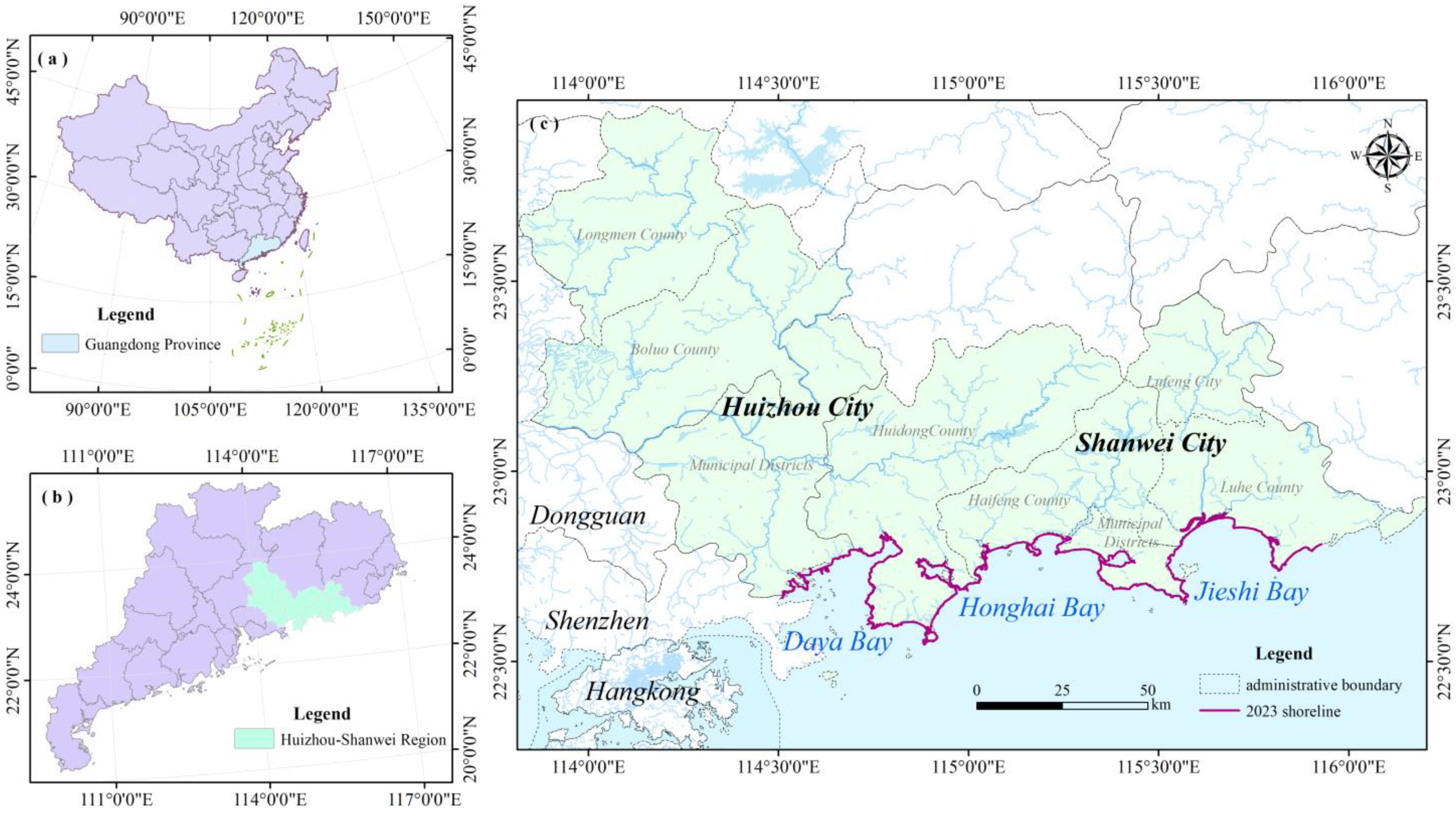
2. Overview of the Study Area
3. Data Sources and Methodolgy
3.1. Data Sources
3.2. Shorelines Extraction and Validation
3.3. Shoreline Artificial Index
3.4. Intensity of Shoreline Change
3.5. Baseline Method for Calculating the Rate of Shorelines Change
3.6. Shorelines Fractal Dimension
4. Results
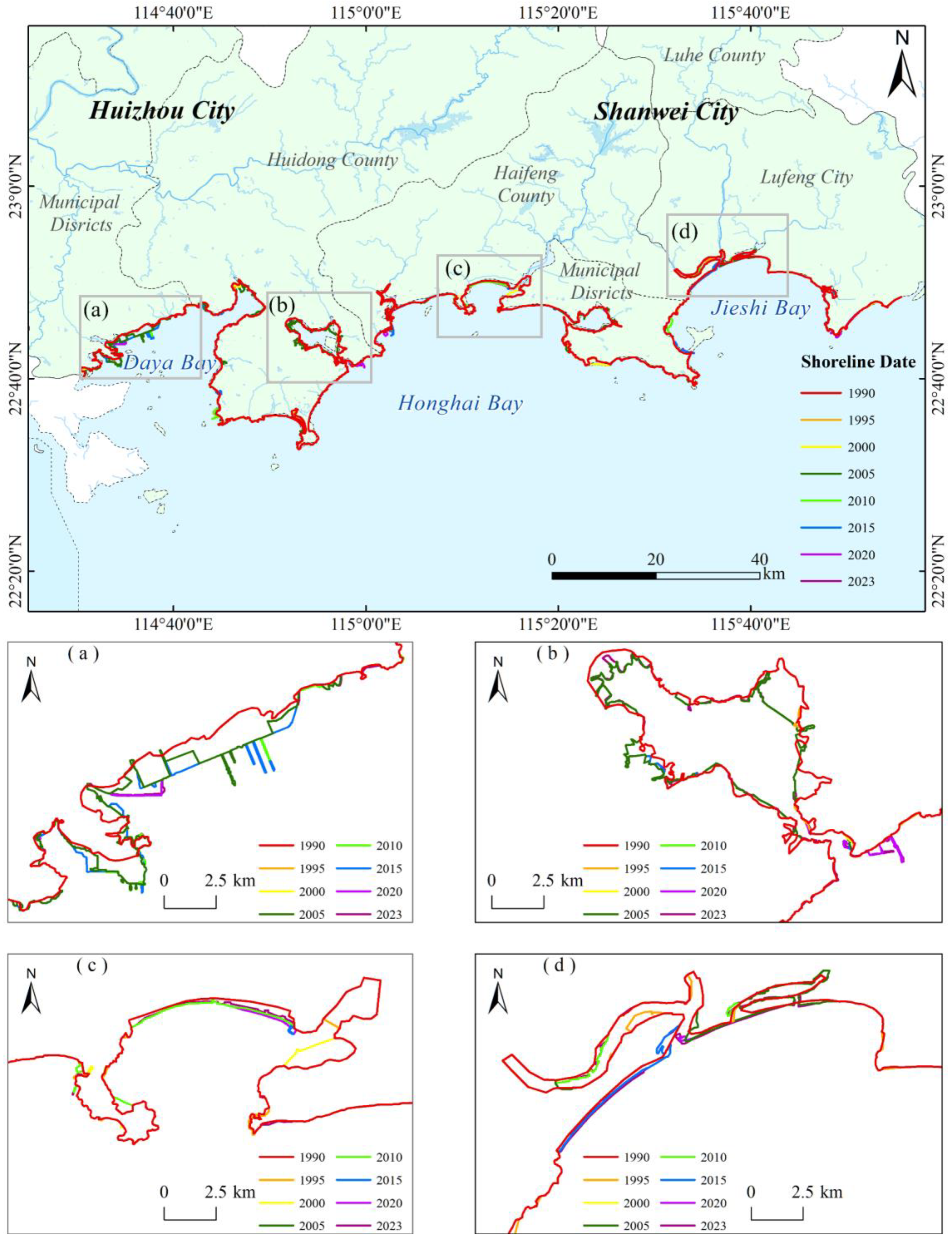
4.1. Analysis of Changes in Shorelines Length and Structure
4.2. Intensity of Shorelines Change
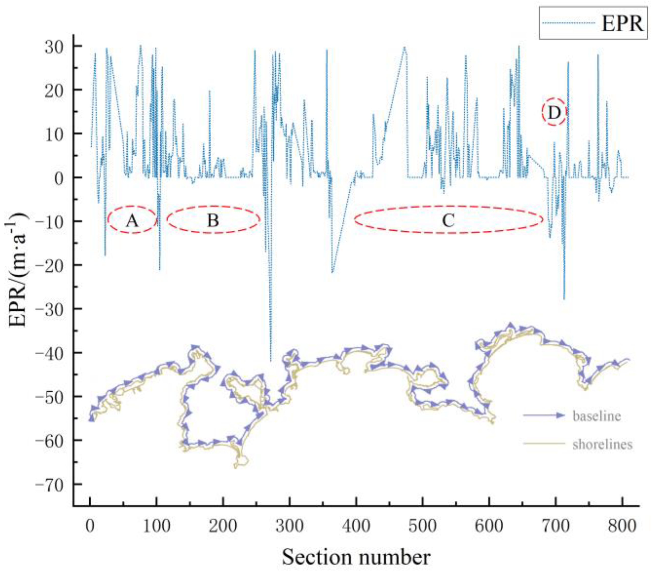
4.3. Rate of Shorelines Change
4.4. Shorelines Fractal Dimension Change
5. Discussion
5.1. Comparative Analysis of Shorelines Variation
5.2. Driving Factor Analysis
5.2.1. Natural Factors
5.2.2. Socio-Economic Factors
5.2.3. Policy Factors
6. Conclusions
Author Contributions
Funding
Data Availability Statement
Acknowledgments
Conflicts of Interest
References
- Zhang, Y.; Hou, X. Characteristics of Coastline Changes on Southeast Asia Islands from 2000 to 2015. Remote Sens. 2020, 12, 519. [Google Scholar] [CrossRef]
- Zheng, Z.; Wu, Z.; Chen, Y.; Yang, Z.; Marinello, F. Exploration of Eco-Environment and Urbanization Changes in Coastal Zones: A Case Study in China over the Past 20 Years. Ecol. Indic. 2020, 119, 106847. [Google Scholar] [CrossRef]
- Almar, R.; Boucharel, J.; Graffin, M.; Abessolo, G.O.; Thoumyre, G.; Papa, F.; Ranasinghe, R.; Montano, J.; Bergsma, E.W.J.; Baba, M.W.; et al. Influence of El Niño on the Variability of Global Shoreline Position. Nat. Commun. 2023, 14, 3133. [Google Scholar] [CrossRef] [PubMed]
- Barbier, E.B. Climate Change Impacts on Rural Poverty in Low-Elevation Coastal Zones. Estuar. Coast. Shelf Sci. 2015, 165, A1–A13. [Google Scholar] [CrossRef]
- Rajasree, B.R.; Deo, M.C.; Sheela Nair, L. Effect of Climate Change on Shoreline Shifts at a Straight and Continuous Coast. Estuar. Coast. Shelf Sci. 2016, 183, 221–234. [Google Scholar] [CrossRef]
- Rangel-Buitrago, N. Human Epoch-Human Responsibility: Rethinking Coastal Zone Management in the Anthropocene. Ocean Coast. Manag. 2023, 244, 106801. [Google Scholar] [CrossRef]
- Wu, T.; Hou, X.; Xu, X. Spatio-Temporal Characteristics of the Mainland Coastline Utilization Degree over the Last 70 Years in China. Ocean Coast. Manag. 2014, 98, 150–157. [Google Scholar] [CrossRef]
- Zhang, X.; Yang, Z.; Zhang, Y.; Ji, Y.; Wang, H.; Lv, K.; Lu, Z. Spatial and Temporal Shoreline Changes of the Southern Yellow River (Huanghe) Delta in 1976–2016. Mar. Geol. 2018, 395, 188–197. [Google Scholar] [CrossRef]
- Zhao, B.; Liu, Y.; Wang, L. Evaluation of the Stability of Muddy Coastline Based on Satellite Imagery: A Case Study in the Central Coasts of Jiangsu, China. Remote Sens. 2023, 15, 3323. [Google Scholar] [CrossRef]
- Wang, X.; Liu, Y.; Ling, F.; Liu, Y.; Fang, F. Spatio-Temporal Change Detection of Ningbo Coastline Using Landsat Time-Series Images during 1976–2015. ISPRS Int. J. Geo-Inf. 2017, 6, 68. [Google Scholar] [CrossRef]
- Mshelia, Z.H.; Amatebelle, E.C.; Belle, J.A. Geospatial Analysis of Shoreline Change of Ethekwini Coastline from 1990–2023. Sci. Afr. 2025, 28, e02685. [Google Scholar] [CrossRef]
- Adenugba, O.; Li, H.; Daramola, S.; Adewale, B.; Gong, Z. Effects of Localized Development on Land Use and Coastline Dynamics: A Focus on Recent Changes along the Lekki Peninsula. Reg. Stud. Mar. Sci. 2024, 78, 103744. [Google Scholar] [CrossRef]
- Sun, J.; Shu, S.; Hu, H.; Deng, Y.; Li, Z.; Zhou, S.; Liu, Y.; Dang, M.; Huang, W.; Hou, Z.; et al. Location Optimization of Unmanned Aerial Vehicle (UAV) Drone Port for Coastal Zone Management: The Case of Guangdong Coastal Zone in China. Ocean Coast. Manag. 2025, 262, 107576. [Google Scholar] [CrossRef]
- Wang, Y.-S.; Lou, Z.-P.; Sun, C.-C.; Sun, S. Ecological Environment Changes in Daya Bay, China, from 1982 to 2004. Mar. Pollut. Bull. 2008, 56, 1871–1879. [Google Scholar] [CrossRef]
- Li, K.; Xu, E. High-Accuracy Continuous Mapping of Surface Water Dynamics Using Automatic Update of Training Samples and Temporal Consistency Modification Based on Google Earth Engine: A Case Study from Huizhou, China. ISPRS J. Photogramm. Remote Sens. 2021, 179, 66–80. [Google Scholar] [CrossRef]
- Liu, X.J.; Xü, J.N.; Kettner, A.J.; Wang, Y.; Yi, J.J. Decadal Shifts and Future Projections of the Han River Delta Coastline. Mar. Geol. 2025, 484, 107520. [Google Scholar] [CrossRef]
- Gairin, E.; Collin, A.; James, D.; Maueau, T.; Roncin, Y.; Lefort, L.; Dolique, F.; Jeanson, M.; Lecchini, D. Spatiotemporal Trends of Bora Bora’s Shoreline Classification and Movement Using High-Resolution Imagery from 1955 to 2019. Remote Sens. 2021, 13, 4692. [Google Scholar] [CrossRef]
- Mu, K.; Tang, C.; Tosi, L.; Li, Y.; Zheng, X.; Donnici, S.; Sun, J.; Liu, J.; Gao, X. Coastline Monitoring and Prediction Based on Long-Term Remote Sensing Data—A Case Study of the Eastern Coast of Laizhou Bay, China. Remote Sens. 2024, 16, 185. [Google Scholar] [CrossRef]
- Yang, F.; Zhang, L.; Chen, B.; Li, K.; Liao, J.; Mahmood, R.; Hasan, M.E.; Mamun, M.M.A.A.; Raza, S.A.; Sutrisno, D. Long-Term Change of Coastline Length along Selected Coastal Countries of Eurasia and African Continents. Remote Sens. 2023, 15, 2344. [Google Scholar] [CrossRef]
- Huang, L.; Zhao, C.; Jiao, C.; Zheng, G.; Zhu, J. Quantitative Analysis of Rapid Siltation and Erosion Caused Coastline Evolution in the Coastal Mudflat Areas of Jiangsu. Water 2023, 15, 1679. [Google Scholar] [CrossRef]
- Mansour, N.; Sarhan, T.; El-Gamal, M.; Nassar, K. Assessing the Compatibility of EPR Rates with One-Dimensional Numerical Modelling in Monitoring Shoreline Kinematics along with Supplying near/Long-Term Forecasts. Reg. Stud. Mar. Sci. 2024, 71, 103391. [Google Scholar] [CrossRef]
- Rafi, S.; Mourya, N.K.; Balasani, R. Evaluation of Shoreline Alteration Along theJagatsinghpur District Coast, India (1990–2020) Using DSAS. Ocean Coast. Manag. 2024, 253, 107132. [Google Scholar] [CrossRef]
- Rahbani, M.; Ghaderi, D. Long Term Investigation on Shoreline Changes of an Island, Inside a Gulf (Hormuz Island). Reg. Stud. Mar. Sci. 2024, 71, 103399. [Google Scholar] [CrossRef]
- Hu, X.; Wang, Y. Coastline Fractal Dimension of Mainland, Island, and Estuaries Using Multi-Temporal Landsat Remote Sensing Data from 1978 to 2018: A Case Study of the Pearl River Estuary Area. Remote Sens. 2020, 12, 2482. [Google Scholar] [CrossRef]
- Manno, G.; Lo Re, C.; Basile, M.; Ciraolo, G. A New Shoreline Change Assessment Approach for Erosion Management Strategies. Ocean Coast. Manag. 2022, 225, 106226. [Google Scholar] [CrossRef]
- Kappraff, J. The Geometry of Coastlines: A Study in Fractals. Comput. Math. Appl. 1986, 12, 655–671. [Google Scholar] [CrossRef]
- Colak, A.T.I. Geospatial Analysis of Shoreline Changes in the Oman Coastal Region (2000–2022) Using GIS and Remote Sensing Techniques. Front. Mar. Sci. 2024, 11, 1305283. [Google Scholar] [CrossRef]
- Al-Attar, I.M.S.; Basheer, M.A. Multi-Temporal Shoreline Analysis and Future Regional Perspective for Kuwait Coast Using Remote Sensing and GIS Techniques. Heliyon 2023, 9, e20001. [Google Scholar] [CrossRef]
- Yuan, R.; Xu, R.; Zhang, H.; Hua, Y.; Zhang, H.; Zhong, X.; Chen, S. Detecting Shoreline Changes on the Beaches of Hainan Island (China) for the Period 2013–2023 Using Multi-Source Data. Water 2024, 16, 1034. [Google Scholar] [CrossRef]
- Anthony, E.J.; Dussouillez, P.; Dolique, F.; Besset, M.; Brunier, G.; Nguyen, V.L.; Goichot, M. Morphodynamics of an Eroding Beach and Foredune in the Mekong River Delta: Implications for Deltaic Shoreline Change. Cont. Shelf Res. 2017, 147, 155–164. [Google Scholar] [CrossRef]
- Yang, L.; Li, J.; Yuan, Q.; Xu, L.; Lu, X.; Wang, M.; Zhao, S. Spatial-Temporal Changes of Continental Coastline in Southern China. J. Mar. Sci. 2014, 32, 42–49. [Google Scholar] [CrossRef]
- Hu, R.; Yao, L.; Yu, J.; Chen, P.; Wang, D. Remote Sensing of the Coastline Variation of the Guangdong–Hongkong–Macao Greater Bay Area in the Past Four Decades. J. Mar. Sci. Eng. 2021, 9, 1318. [Google Scholar] [CrossRef]
- Gao, W.; Du, J.; Gao, S.; Xu, Y.; Li, B.; Wei, X.; Zhang, Z.; Liu, J.; Li, P. Shoreline Change Due to Global Climate Change and Human Activity at the Shandong Peninsula from 2007 to 2020. Front. Mar. Sci. 2023, 9, 1123067. [Google Scholar] [CrossRef]


| Landsat Scene Identifier | Satellite and Sensor Identifier | Path/ Row | Spatial Resolution | Date | Cloud Cover |
|---|---|---|---|---|---|
| LT51210441990327BJC00 | LANDSAT5 TM | 121/44 | 30 m | 23 November 1990 | 0 |
| LT51210441995085CLT03 | LANDSAT5 TM | 121/44 | 30 m | 26 March 1995 | 0 |
| LT51210442000259BJC00 | LANDSAT5 TM | 121/44 | 30 m | 15 September 2000 | 0 |
| LT51210442005064BJC00 | LANDSAT5 TM | 121/44 | 30 m | 5 March 2005 | 0 |
| LE71210442010342EDC00 | LANDSAT7 ETM | 121/44 | 30 m | 8 December 2010 | 0 |
| LC81210442015220LGN01 | LANDSAT8_OLI_TIRS | 121/44 | 30 m | 8 August 2015 | 5.96 |
| LC81210442020106LGN00 | LANDSAT8_OLI_TIRS | 121/44 | 30 m | 15 April 2020 | 4.88 |
| LC91210442023106LGN00 | LANDSAT9_OLI_TIRS | 121/44 | 30 m | 16 April 2023 | 0.58 |
| Type | Photo | Description |
|---|---|---|
| artificial |  | It is grayish-white and linear, with a straight waterside line; farmed areas or salt flats are regularly blocky. |
| biogenic |  | Shorelines with predominantly mangrove-growing and other marine forested shores are imaged in patches. |
| sandy |  | Smooth water’s edge; bright white, even tone in areas not reached by the tide, darker tone in areas wetted by the tide; strips of beach with clear boundaries to land vegetation and sea water |
| muddy |  | Darker color tone, dense vegetation on one side, sparse or no vegetation on the other, generally with tidal flume development. |
| rocky |  | It has typical textural features. The rocks are light-toned and striped on remote sensing images, and the coast is often dotted with reefs, boulders, sea cliffs and other landforms. |
| estuarine |  | Located at the mouth of the Sea River, it is irregular in shape and undergoes a marked change in hue. |
| Types | Artificial | Biogenic | Sandy | Muddy | Rocky | Estuarine | All | ||
|---|---|---|---|---|---|---|---|---|---|
| Years | |||||||||
| 1990 | 178.53 | 9.90 | 187.69 | 8.73 | 223.82 | 8.04 | 616.71 | 0.2895 | |
| 1995 | 180.33 | 7.90 | 186.38 | 7.84 | 223.00 | 1.38 | 606.83 | 0.2972 | |
| 2000 | 185.84 | 7.90 | 183.81 | 8.83 | 216.00 | 1.38 | 603.76 | 0.3078 | |
| 2005 | 269.12 | 7.80 | 166.24 | 9.70 | 163.68 | 1.35 | 617.89 | 0.4356 | |
| 2010 | 274.76 | 7.13 | 165.93 | 15.75 | 159.22 | 1.35 | 624.14 | 0.4402 | |
| 2015 | 295.13 | 13.66 | 174.40 | 12.08 | 133.81 | 1.28 | 630.35 | 0.4682 | |
| 2020 | 281.43 | 12.97 | 187.26 | 10.50 | 140.75 | 1.28 | 634.19 | 0.4438 | |
| 2023 | 271.68 | 3.11 | 194.72 | 5.08 | 157.04 | 0.90 | 632.54 | 0.4295 | |
| Type | Artificial | Biogenic | Sandy | Muddy | Rocky | Estuarine | Total | |
|---|---|---|---|---|---|---|---|---|
| Period | ||||||||
| 1990–1995 | 0.20% | −4.05% | −0.14% | −2.04% | −0.07% | −16.57% | −0.32% | |
| 1995–2000 | 0.61% | 0.00% | −0.28% | 2.52% | −0.63% | 0.00% | −0.10% | |
| 2000–2005 | 8.96% | −0.25% | −1.91% | 1.98% | −4.85% | −0.40% | 0.47% | |
| 2005–2010 | 0.42% | −1.71% | −0.04% | 12.47% | −0.54% | 0.00% | 0.20% | |
| 2010–2015 | 1.48% | 18.30% | 1.02% | −4.66% | −3.19% | −1.14% | 0.20% | |
| 2015–2020 | −0.93% | −1.00% | 1.48% | −2.61% | 1.04% | 0.00% | 0.12% | |
| 2020–2023 | −1.15% | −25.35% | 1.33% | −17.22% | 3.86% | −9.69% | −0.09% | |
| 1990–2023 | 1.58% | −2.08% | 0.11% | −1.27% | −0.90% | −2.69% | 0.08% | |
| Year | Equation of Linear Regression | R2 | Fractal Dimension |
|---|---|---|---|
| 1990 | 0.9997 | 1.0395 | |
| 1995 | 0.9997 | 1.04 | |
| 2000 | 0.9995 | 1.0447 | |
| 2005 | 0.9996 | 1.0594 | |
| 2010 | 0.9996 | 1.0615 | |
| 2015 | 0.9996 | 1.0671 | |
| 2020 | 0.9997 | 1.0673 | |
| 2023 | 0.9996 | 1.0662 |
Disclaimer/Publisher’s Note: The statements, opinions and data contained in all publications are solely those of the individual author(s) and contributor(s) and not of MDPI and/or the editor(s). MDPI and/or the editor(s) disclaim responsibility for any injury to people or property resulting from any ideas, methods, instructions or products referred to in the content. |
© 2025 by the authors. Licensee MDPI, Basel, Switzerland. This article is an open access article distributed under the terms and conditions of the Creative Commons Attribution (CC BY) license (https://creativecommons.org/licenses/by/4.0/).
Share and Cite
Li, S.; Gui, F.; Feng, J.; Wang, Y.; Song, Y.; Wang, W.; Lin, C. Analysis of Shoreline Change in Huizhou–Shanwei Region (China) from 1990 to 2023. Water 2025, 17, 1460. https://doi.org/10.3390/w17101460
Li S, Gui F, Feng J, Wang Y, Song Y, Wang W, Lin C. Analysis of Shoreline Change in Huizhou–Shanwei Region (China) from 1990 to 2023. Water. 2025; 17(10):1460. https://doi.org/10.3390/w17101460
Chicago/Turabian StyleLi, Sizheng, Feng Gui, Jirong Feng, Yang Wang, Yanwei Song, Wanhu Wang, and Cong Lin. 2025. "Analysis of Shoreline Change in Huizhou–Shanwei Region (China) from 1990 to 2023" Water 17, no. 10: 1460. https://doi.org/10.3390/w17101460
APA StyleLi, S., Gui, F., Feng, J., Wang, Y., Song, Y., Wang, W., & Lin, C. (2025). Analysis of Shoreline Change in Huizhou–Shanwei Region (China) from 1990 to 2023. Water, 17(10), 1460. https://doi.org/10.3390/w17101460


