
Characterization of a Contaminated Site Using Hydro-Geophysical Methods: From Large-Scale ERT Surface Investigations to Detailed ERT and GPR Cross-Hole Monitoring


 , ,
, , 
Abstract
1. Introduction
2. Site Description
2.1. Geological Framework
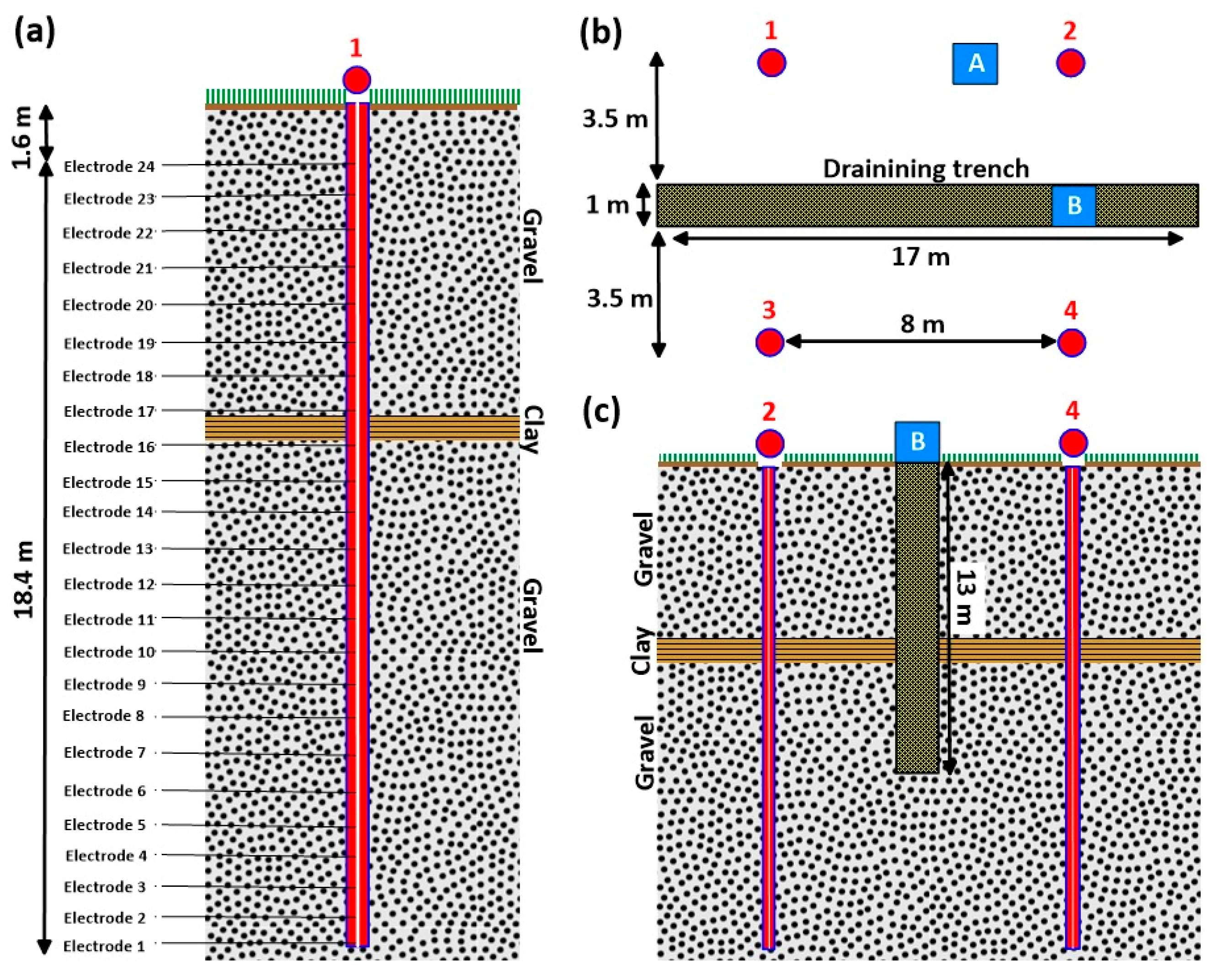
2.2. Experimental Area
3. Methods
3.1. Electrical Resistivity Tomography (ERT)
3.1.1. ERT Forward Modelling
3.1.2. ERT Inverse Modelling
3.1.3. ERT Time-Lapse Survey
3.1.4. ERT Data Acquisition
3.2. Ground-Penetrating Radar (GPR)
4. Results
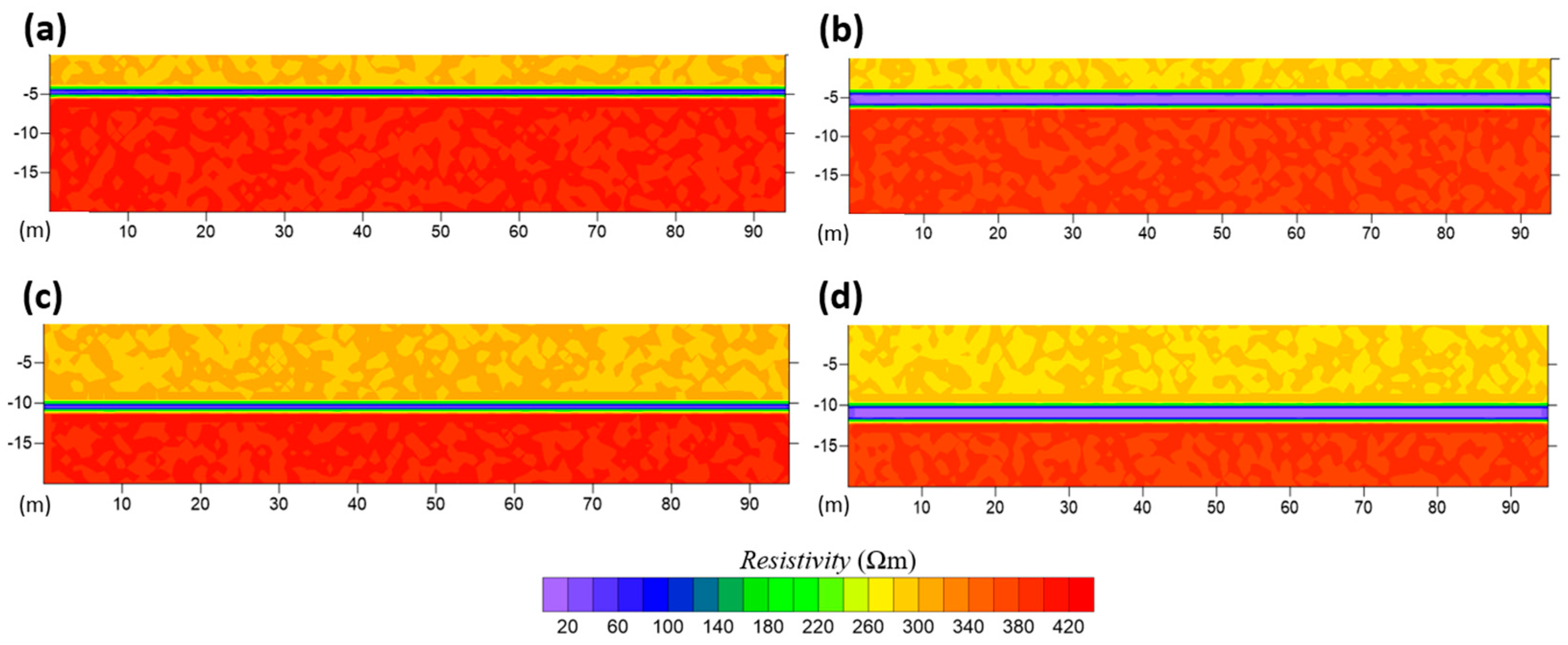
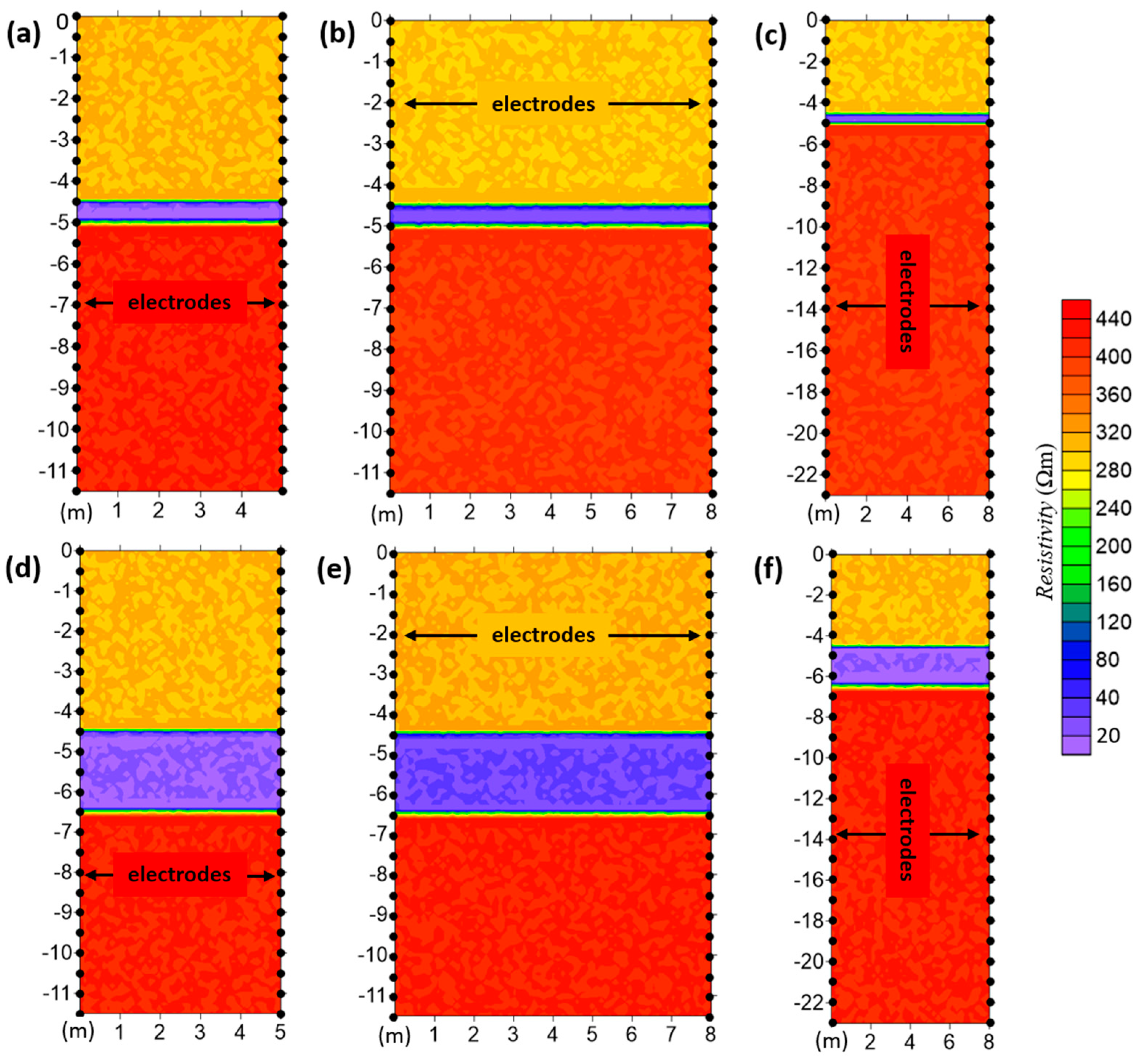
4.1. ERT Forward Modelling Results
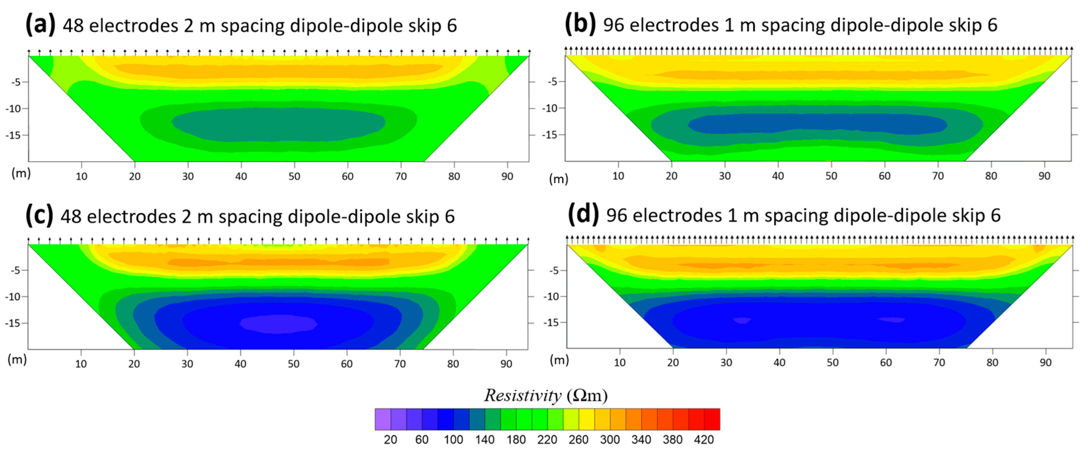
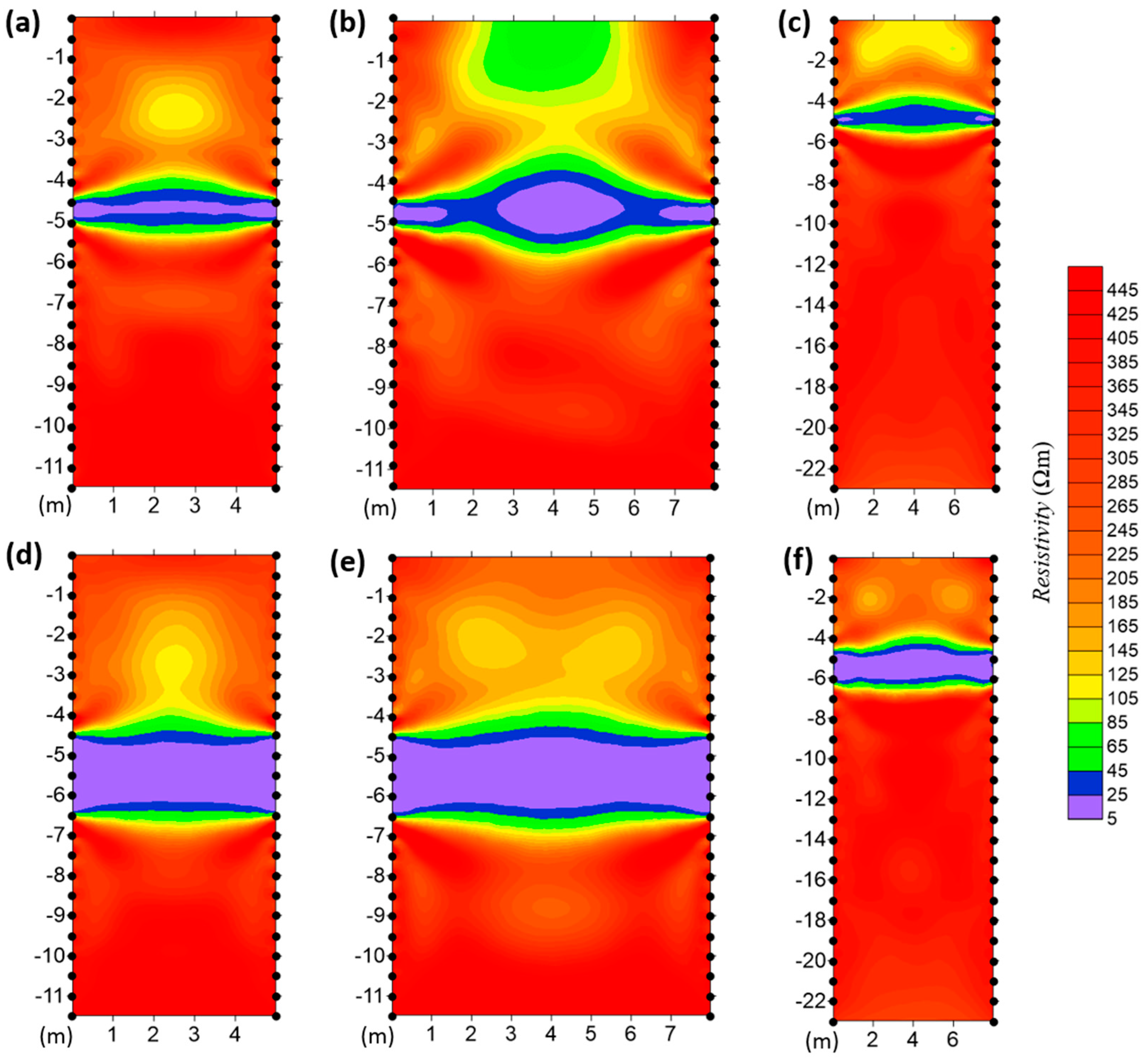
4.2. ERT Field Data Inversion
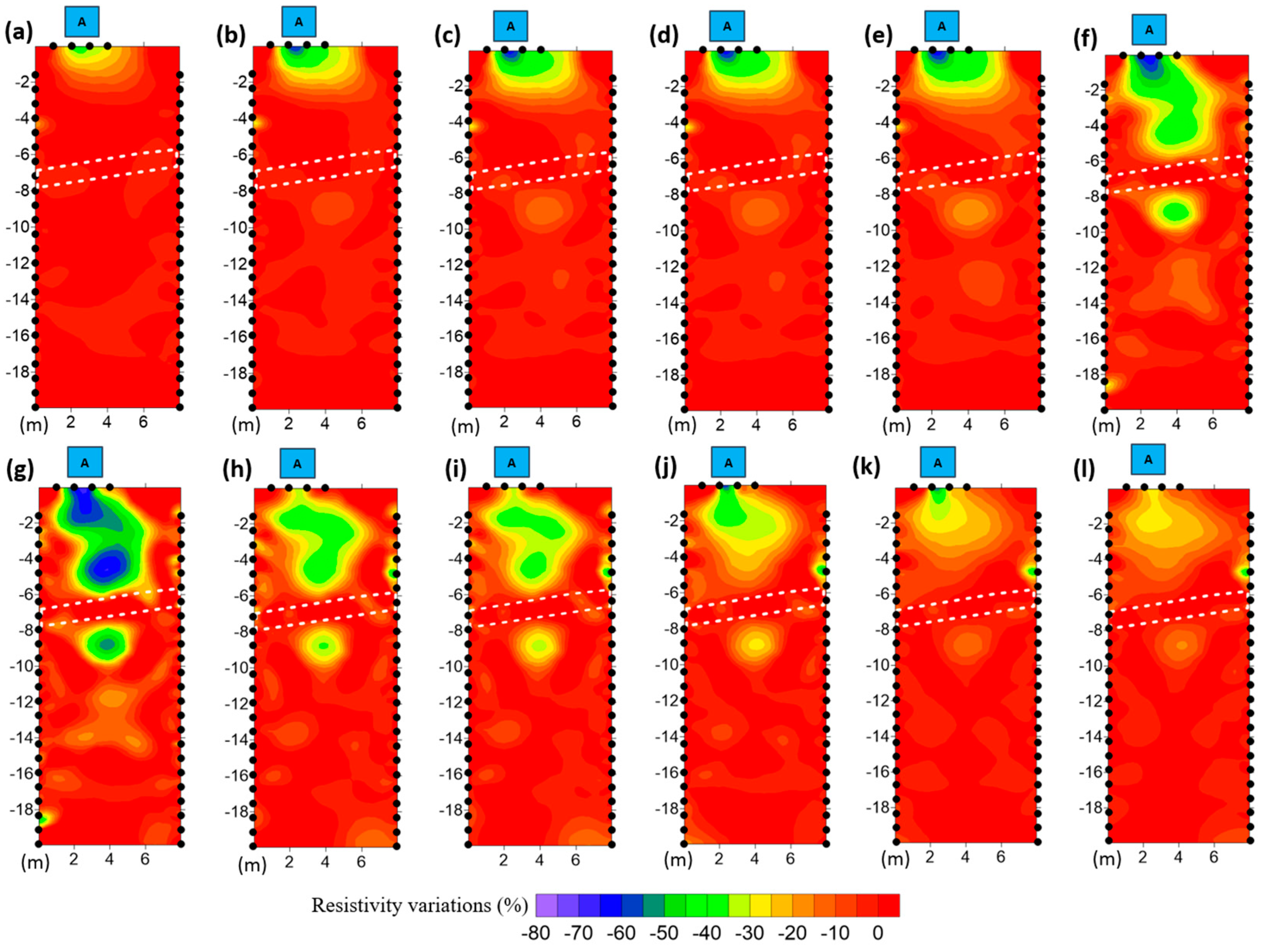
4.3. ERT Time-Lapse Inversions during Water Infiltration Experiments
4.4. GPR Monitoring during Water Infiltration Experiments
5. Discussion
6. Conclusions
Author Contributions
Funding
Data Availability Statement
Acknowledgments
Conflicts of Interest
References
- Cassiani, G.; Binley, A.; Kemna, A.; Wehrer, M.; Orozco, A.F.; Deiana, R.; Boaga, J.; Rossi, M.; Dietrich, P.; Werban, U.; et al. Noninvasive Characterization of the Trecate (Italy) Crude-Oil Contaminated Site: Links between Contamination and Geophysical Signals. Environ. Sci. Pollut. Res. 2014, 21, 8914–8931. [Google Scholar] [CrossRef] [PubMed]
- Binley, A.; Hubbard, S.S.; Huisman, J.A.; Revil, A.; Robinson, D.A.; Singha, K.; Slater, L.D. The Emergence of Hydrogeophysics for Improved Understanding of Subsurface Processes over Multiple Scales. Water Resour. Res. 2015, 51, 3837–3866. [Google Scholar] [CrossRef]
- Wang, T.P.; Chen, C.C.; Tong, L.T.; Chang, P.Y.; Chen, Y.C.; Dong, T.H.; Cheng, S.N. Applying FDEM, ERT and GPR at a site with soil contamination: A case study. J. Appl. Geophys. 2015, 121, 21–30. [Google Scholar] [CrossRef]
- Godio, A.; Arato, A.; Stocco, S. Geophysical Characterization of a Nonaqueous-Phase Liquid–Contaminated Site. Environ. Geosci. 2010, 17, 141–161. [Google Scholar] [CrossRef]
- Binley, A. Tools and Techniques: Electrical Methods. In Treatise on Geophysics; Elsevier: Amsterdam, The Netherlands, 2015; pp. 233–259. [Google Scholar]
- Doetsch, J.; Linde, N.; Pessognelli, M.; Green, A.G.; Günther, T. Constraining 3-D Electrical Resistance Tomography with GPR Reflection Data for Improved Aquifer Characterization. J. Appl. Geophys. 2012, 78, 68–76. [Google Scholar] [CrossRef]
- Santi, P.M.; McCray, J.E.; Martens, J.L. Investigating Cross-Contamination of Aquifers. Hydrogeol. J. 2006, 14, 51–68. [Google Scholar] [CrossRef]
- Doetsch, J.; Linde, N.; Binley, A. Structural Joint Inversion of Time-lapse Crosshole ERT and GPR Traveltime Data. Geophys. Res. Lett. 2010, 37. [Google Scholar] [CrossRef]
- Deiana, R.; Cassiani, G.; Kemna, A.; Villa, A.; Bruno, V.; Bagliani, A. An Experiment of Non-invasive Characterization of the Vadose Zone via Water Injection and Cross-hole Time-lapse Geophysical Monitoring. Near Surf. Geophys. 2007, 5, 183–194. [Google Scholar] [CrossRef]
- Steelman, C.M.; Klazinga, D.R.; Cahill, A.G.; Endres, A.L.; Parker, B.L. Monitoring the evolution and migration of a methane gas plume in an unconfined sandy aquifer using time-lapse GPR and ERT. J. Contam. Hydrol. 2017, 205, 12–24. [Google Scholar] [CrossRef]
- Fontana, A.; Mozzi, P.; Marchetti, M. Alluvial Fans and Megafans along the Southern Side of the Alps. Sediment. Geol. 2014, 301, 150–171. [Google Scholar] [CrossRef]
- Fontana, A.; Mozzi, P.; Bondesan, A. Alluvial Megafans in the Venetian–Friulian Plain (North-Eastern Italy): Evidence of Sedimentary and Erosive Phases during Late Pleistocene and Holocene. Quat. Int. 2008, 189, 71–90. [Google Scholar] [CrossRef]
- Hippe, K.; Fontana, A.; Hajdas, I.; Ivy-Ochs, S. A High-Resolution 14 C Chronology Tracks Pulses of Aggradation of Glaciofluvial Sediment on the Cormor Megafan between 45 and 20 Ka BP. Radiocarbon 2018, 60, 857–874. [Google Scholar] [CrossRef]
- Fontana, A.; Rossato, S.; Poli, M.E.; Furlani, S.; Stefani, C. Carta delle Unità Geologiche della Pianura del Friuli Venezia Giulia: Scala 1:150.000; Università degli Studi di Trieste: Trieste, Italy, 2019; ISBN 9788894039429. [Google Scholar]
- Binley, A.; Kemna, A. DC Resistivity and Induced Polarization Methods. In Hydrogeophysics; Rubin, Y., Hubbard, S.S., Eds.; Springer: Dordrecht, The Netherlands, 2005; pp. 129–156. [Google Scholar]
- Blanchy, G.; Saneiyan, S.; Boyd, J.; McLachlan, P.; Binley, A. ResIPy, an Intuitive Open Source Software for Complex Geoelectrical Inversion/Modeling. Comput. Geosci. 2020, 137, 104423. [Google Scholar] [CrossRef]
- Wagner, F.M.; Uhlemann, S. An Overview of Multimethod Imaging Approaches in Environmental Geophysics. In Advances in Geophysics; Elsevier: Amsterdam, The Netherlands, 2021; pp. 1–72. [Google Scholar]
- Constable, S.C.; Parker, R.L.; Constable, C.G. Occam’s Inversion: A Practical Algorithm for Generating Smooth Models from Electromagnetic Sounding Data. Geophysics 1987, 52, 289–300. [Google Scholar] [CrossRef]
- Slater, L.; Binley, A. Synthetic and Field-Based Electrical Imaging of a Zerovalent Iron Barrier: Implications for Monitoring Long-Term Barrier Performance. Geophysics 2006, 71, B129–B137. [Google Scholar] [CrossRef]
- Pavoni, M.; Carrera, A.; Boaga, J. Improving the Galvanic Contact Resistance for Geoelectrical Measurements in Debris Areas: A Case Study. Near Surf. Geophys. 2022, 20, 178–191. [Google Scholar] [CrossRef]
- Pavoni, M.; Boaga, J.; Carrera, A.; Zuecco, G.; Carturan, L.; Zumiani, M. Brief Communication: Mountain Permafrost Acts as an Aquitard during an Infiltration Experiment Monitored with Electrical Resistivity Tomography Time-Lapse Measurements. Cryosphere 2023, 17, 1601–1607. [Google Scholar] [CrossRef]
- Pavoni, M.; Boaga, J.; Wagner, F.M.; Bast, A.; Phillips, M. Characterization of Rock Glaciers Environments Combining Structurally-Coupled and Petrophysically-Coupled Joint Inversions of Electrical Resistivity and Seismic Refraction Datasets. J. Appl. Geophys. 2023, 215, 105097. [Google Scholar] [CrossRef]
- Nielson, T.; Bradford, J.; Pierce, J.; Seyfried, M. Soil Structure and Soil Moisture Dynamics Inferred from Time-Lapse Electrical Resistivity Tomography. Catena 2021, 207, 105553. [Google Scholar] [CrossRef]
- Lapenna, V.; Perrone, A. Time-Lapse Electrical Resistivity Tomography (TL-ERT) for Landslide Monitoring: Recent Advances and Future Directions. Appl. Sci. 2022, 12, 1425. [Google Scholar] [CrossRef]
- Doetsch, J.; Linde, N.; Vogt, T.; Binley, A.; Green, A.G. Imaging and quantifying salt-tracer transport in a riparian groundwater system by means of 3D ERT monitoring. Geophysics 2012, 77, B207–B218. [Google Scholar] [CrossRef]
- Daily, W.; Ramirez, A.; LaBrecque, D.; Nitao, J. Electrical Resistivity Tomography of Vadose Water Movement. Water Resour. Res. 1992, 28, 1429–1442. [Google Scholar] [CrossRef]
- Topp, G.C.; Davis, J.L. Measurement of Soil Water Content Using Time-domain Reflectrometry (TDR): A Field Evaluation. Soil Sci. Soc. Am. J. 1985, 49, 19–24. [Google Scholar] [CrossRef]
- Roth, K.; Schulin, R.; Flühler, H.; Attinger, W. Calibration of Time Domain Reflectometry for Water Content Measurement Using a Composite Dielectric Approach. Water Resour. Res. 1990, 26, 2267–2273. [Google Scholar] [CrossRef]
- van Overmeeren, R.A.; Sariowan, S.V.; Gehrels, J.C. Ground Penetrating Radar for Determining Volumetric Soil Water Content; Results of Comparative Measurements at Two Test Sites. J. Hydrol. 1997, 197, 316–338. [Google Scholar] [CrossRef]
- Robinson, D.A.; Friedman, S.P. A Method for Measuring the Solid Particle Permittivity or Electrical Conductivity of Rocks, Sediments, and Granular Materials. J. Geophys. Res. Solid Earth 2003, 108. [Google Scholar] [CrossRef]
- Rossi, M.; Cassiani, G.; Binley, A. A Stochastic Analysis of Cross-Hole Ground-Penetrating Radar Zero-Offset Profiles for Subsurface Characterization. Vadose Zone J. 2012, 11, vzj2011-0078. [Google Scholar] [CrossRef]
- Parkin, G.; Redman, D.; Von Bertoldi, P.; Zhang, Z. Measurement of soil water content below a wastewater trench using ground-penetrating radar. Water Resour. Res. 2000, 36, 2147–2154. [Google Scholar] [CrossRef]
- Deiana, R.; Cassiani, G.; Villa, A.; Bagliani, A.; Bruno, V. Calibration of a Vadose Zone Model Using Water Injection Monitored by GPR and Electrical Resistance Tomography. Vadose Zone J. 2008, 7, 215–226. [Google Scholar] [CrossRef]
- Pringle, J.K.; Westerman, A.R.; Clark, J.D.; Guest, J.A.; Ferguson, R.J.; Gardiner, A.R. The use of vertical radar profiling (VRP) in GPR surveys of ancient sedimentary strata. In Ground Penetrating Radar in Sediments; Geological Society: London, UK, 2003; Volume 211, pp. 225–246. [Google Scholar] [CrossRef]
- Doetsch, J.A.; Coscia, I.; Greenhalgh, S.; Linde, N.; Green, A.; Günther, T. The Borehole-Fluid Effect in Electrical Resistivity Imaging. Geophysics 2010, 75, F107–F114. [Google Scholar] [CrossRef]
- LaBrecque, D.; Alumbaugh, D.L.; Yang, X.; Paprocki, L.; Brainard, J. Chapter 15 Three-Dimensional Monitoring of Vadose Zone Infiltration Using Electrical Resistivity Tomography and Cross-Borehole Ground-Penetrating Radar. In Methods in Geochemistry and Geophysics; Elsevier: Amsterdam, The Netherlands, 2002; pp. 259–272. [Google Scholar]
- Topp, G.C.; Davis, J.L.; Annan, A.P. Electromagnetic Determination of Soil Water Content: Measurements in Coaxial Transmission Lines. Water Resour. Res. 1980, 16, 574–582. [Google Scholar] [CrossRef]


| Time | ERT Time Step | Water Released |
|---|---|---|
| 11.00 | t0 | - |
| 12:00 | - | Start |
| 12:35 | t1 | 1000 L |
| 13:08 | t2 | 2000 L |
| 13:45 | t3 | 3000 L |
| 14:20 | t4 | 4000 L |
| 14:55 | t5 | 5000 L |
| 15:30 | t6 | 6000 L |
| 16:00 | t7 | 7000 L |
| 21:30 | - | 16,600 L (End) |
| 07:50 (+1 day) | t8 | - |
| 10:00 (+1 day) | t9 | - |
| 12:00 (+1 day) | t10 | - |
| 14:00 (+1 day) | t11 | - |
| 16:00 (+1 day) | t12 | - |
Disclaimer/Publisher’s Note: The statements, opinions and data contained in all publications are solely those of the individual author(s) and contributor(s) and not of MDPI and/or the editor(s). MDPI and/or the editor(s) disclaim responsibility for any injury to people or property resulting from any ideas, methods, instructions or products referred to in the content. |
© 2024 by the authors. Licensee MDPI, Basel, Switzerland. This article is an open access article distributed under the terms and conditions of the Creative Commons Attribution (CC BY) license (https://creativecommons.org/licenses/by/4.0/).
Share and Cite
Pavoni, M.; Boaga, J.; Peruzzo, L.; Barone, I.; Mary, B.; Cassiani, G. Characterization of a Contaminated Site Using Hydro-Geophysical Methods: From Large-Scale ERT Surface Investigations to Detailed ERT and GPR Cross-Hole Monitoring. Water 2024, 16, 1280. https://doi.org/10.3390/w16091280
Pavoni M, Boaga J, Peruzzo L, Barone I, Mary B, Cassiani G. Characterization of a Contaminated Site Using Hydro-Geophysical Methods: From Large-Scale ERT Surface Investigations to Detailed ERT and GPR Cross-Hole Monitoring. Water. 2024; 16(9):1280. https://doi.org/10.3390/w16091280
Chicago/Turabian StylePavoni, Mirko, Jacopo Boaga, Luca Peruzzo, Ilaria Barone, Benjamin Mary, and Giorgio Cassiani. 2024. "Characterization of a Contaminated Site Using Hydro-Geophysical Methods: From Large-Scale ERT Surface Investigations to Detailed ERT and GPR Cross-Hole Monitoring" Water 16, no. 9: 1280. https://doi.org/10.3390/w16091280
APA StylePavoni, M., Boaga, J., Peruzzo, L., Barone, I., Mary, B., & Cassiani, G. (2024). Characterization of a Contaminated Site Using Hydro-Geophysical Methods: From Large-Scale ERT Surface Investigations to Detailed ERT and GPR Cross-Hole Monitoring. Water, 16(9), 1280. https://doi.org/10.3390/w16091280