Article

Risk Assessment of Water Inrush from Coal Seam Roof Based on the Combined Weighting of the Geographic Information System and Game Theory: A Case Study of Dananhu Coal Mine No. 7, China

1
School of Resources and Geoscience, China University of Mining and Technology, Xuzhou 221116, China
2
China Coal Group Xinjiang Energy Co., Ltd., Urumqi 830000, China
*
Author to whom correspondence should be addressed.
Water 2024, 16(5), 710; https://doi.org/10.3390/w16050710
Submission received: 8 February 2024 / Revised: 23 February 2024 / Accepted: 25 February 2024 / Published: 28 February 2024

Abstract

:
Coal mines’ water inrush is one of the five major disasters that affect the safety of coal mine production. The assessment of coal mines’ water inrush is a prerequisite for preventing and controlling coal mines’ water inrush. To objectively and effectively evaluate the risk of water inrush in the coal seam roof and overcome the shortage of single assignment methods, two methods, the analytic hierarchy process and the entropy method, are used in this paper to determine each evaluation factor’s subjective and objective consequences. Game theory is applied to obtain the combined weights of each influencing factor to make up for the lack of a single assignment method. Taking the roof of Coal Seam No. 7 in mining Areas I and II of Dananhu Coal Mine No. 7 as an example, six primary evaluation indexes are created to control water inrush in the coal seam roof. The comprehensive weights of each index is determined; a vulnerability index evaluation model is established; and the results of the water inrush risk zone in the coal seam roof of Dananhu Coal Mine No. 7 are obtained using the GIS spatial analysis function. The results show that the discriminatory effects of the zoning model have a high accuracy and can provide a reference basis for future coal seam mining control work in this mine.

1. Introduction

Mine safety is a primary industry concern. Among the various safety risks, water inrush in mines is sudden, hidden, and dangerous, posing a severe threat to the lives and safety of underground workers [1]. According to incomplete statistics, from 2008 to 2021, there were 1177 coal mine safety accidents in mainland China (excluding Hong Kong and Macao), resulting in 4956 deaths. Of these, 153 were water inrush accidents, causing 747 deaths. These water inrush accidents accounted for 13.0% of all the accidents and 15.1% of all the deaths. Therefore, it is essential to conduct an objective and accurate evaluation of the risk of water inrush in coal seams [2].
Water bursting from the apical bed takes place when water gathered on the roof of a coal seam suddenly gushes or seeps into the working face during mining. This can be due to geological conditions, coal mining techniques, and mine drainage. Academics Liu Tianquan and Qian Minggao have put forward the theory of the “upper three zones” and the key strata theory, respectively, to provide a theoretical basis for predicting coal seam water inrush. Predicting the risk of water inrush from the roof of a coal seam involves estimating the height of two zones and the water yield property of the water–bearing layer [3,4,5,6]. Currently, the more effective methods of mine water burst prediction [7] include geological environment predictive analysis, mathematical and computer module predictive analysis, physical prospecting exploration predictive analysis, and hydrochemistry ion and isotope predictive analysis.
The water source discrimination model has been constructed by many experts and scholars through the collection of water chemistry information during periods threatening water inrush, using water chemistry analysis, mathematical analysis, artificial neural networks, topologically recognizable identification, support vector machines, and other methods, and have achieved quite rich research results [8,9]. Among the representative mathematical and computer module predictive analysis techniques are cluster analysis model prediction, neural network model prediction, regression analysis model prediction, geographic information system (GIS) technology, and multivariate information composite technology in remote sensing technology. Wu et al. [10,11] and Zeng et al. [12] proposed the ‘three diagrams—double prediction method’ to analyze the risk of roof water inrush. This method overlays diagrams of water yield properties, caving zone, and water inrush conditions to predict the amount of water gushing and the aquifer water release scheme. Zhang et al. [13] combined two methods, AHP and GRA, to obtain qualitative and quantitative indexes for the prediction model of roof burst water in shallow coal seam mining and constructed a comprehensive evaluation model. Fan et al. [14] proposed an assessment index for the evaluation of aquiclude stability and the connection between this and roof water inrush. Ruan et al. [15] expanded and improved the analytical hierarchy process using the Dempster–Shafer evidence theory to obtain weight coefficients for influencing factors and used this to show a new model of assessing the risk of water inrush in the Wangjialing Coal Mine. Sun et al. [16] used the hierarchical analysis method–entropy value method (AHP–EM) to propose a water inrush risk index, and the water–rich structure index was proposed based on geological data–coupled calculations, which were then weighted to establish a comprehensive water inrush risk assessment method.
Among them, the vulnerability evaluation method is also widely used. Yu et al. [17] and Yin [18] used AHP and ArcGIS to create a risk zoning map for water inrush in the roof of a mine based on multiple control factors and the mine’s hydrogeological conditions. Lu et al. [19] used FAHP and EM to determine the overall weights of each assessment factor and then used the GIS’s spatial overlay capabilities to create a bed–separation water inrush risk evaluation partition map for the Yangliu Coal Mine compartment. Li et al. [20] used the GIS and the analytic network process (ANP) to establish a water–rich evaluation model of the karst aquifer at the top of the Xiaotun coal seam and combined it with the height of the water flow–fractured zone obtained through numerical simulation to achieve water inrush hazard zoning. This paper focuses on the game theory method to coordinate the combination weighting problem of both the AHP and the entropy method, combined with the powerful spatial analysis function of the GIS, to obtain the evaluation results of the risk of water inrush in the roof of Coal Seam No. 7 of Dananhu Coal Mine No. 7.

2. Study Area and Mining Conditions

Dananhu Coal Mine No. 7 is located 40 km in the 190° direction of Hami city, and its political division is under the jurisdiction of the Nanhu township, Hami city. The wellfield measures 13.6 km in length from east to west and 5.5–11.5 km in width from north to south, covering an area of 85.37 km2. According to the master plan, the Danan Lake coal mining area No. 7 is located east of the Dananhu mining area (see Figure 1). The coal seams within the wellfield were all deposited in the Middle Jurassic Xishanyao Formation (J), according to the 95 drill holes constructed in the exploration area, of which 91 holes (including the far–adjusted holes ZK521 and ZK522) contain 29 layers of numbered coal seams, among which the recoverable seams comprise 18 layers, which are mainly located in the middle coal–bearing section of the Xishanyao Formation (J2×2) and the lower coal–bearing section (J2×1), in which the middle coal–bearing section (J2×2) is the main coal–bearing section.
The mine site is in the Tu–ha basin, a Middle Cenozoic inter–mountain depression basin. The basin is long and strip–shaped, broad in the west and narrow in the east, with well–exposed central outcrops and rock formations from the Paleoproterozoic–Neoproterozoic and Quaternary systems covering the eastern and western ends. The area has few internal faults, but positive regional defects are present along the southern edge with a north–east trend, a south–east tendency, and a steep dip [21]. In this excellent field, fracture structures are infrequent, and a few high–angle faults facing the north–east exist.
Dananhu Coal Mine No. 7 can be divided into one permeable layer, three water–bearing layers (sections), and five water–separating layers (sections), with the vertical distribution map found in Figure 2. The direct water–filled aquifers in the coal roof of Dananhu Coal Mine No. 7 are mainly the Jurassic Middle Toutunhe Group fissure–pore weak aquifer and the middle part of the Xishangyao Group fissure–pore aquifer, in which the water richness of the Toutunhe Group fissure–pore fragile aquifer is extremely weak and regarded as a relative water barrier. The lithology is mainly sandstone, mudstone, sandy mudstone, and coal seam, and a small amount of medium conglomerate is seen.

3. Materials and Methods

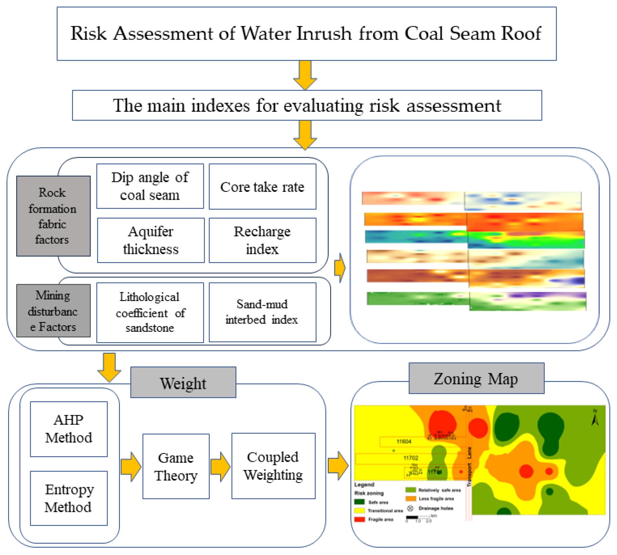
The evaluation of water richness in a coal roof consists of four steps: (1) identification of factors influencing water richness in the coal roof and collection of geological data; (2) determination of indicator weights; (3) data normalization and establishment of indicator models; and (4) description and validation of the results. The process is illustrated in Figure 3.

3.1. Selection of Main Control Factors and Creation of Thematic Maps

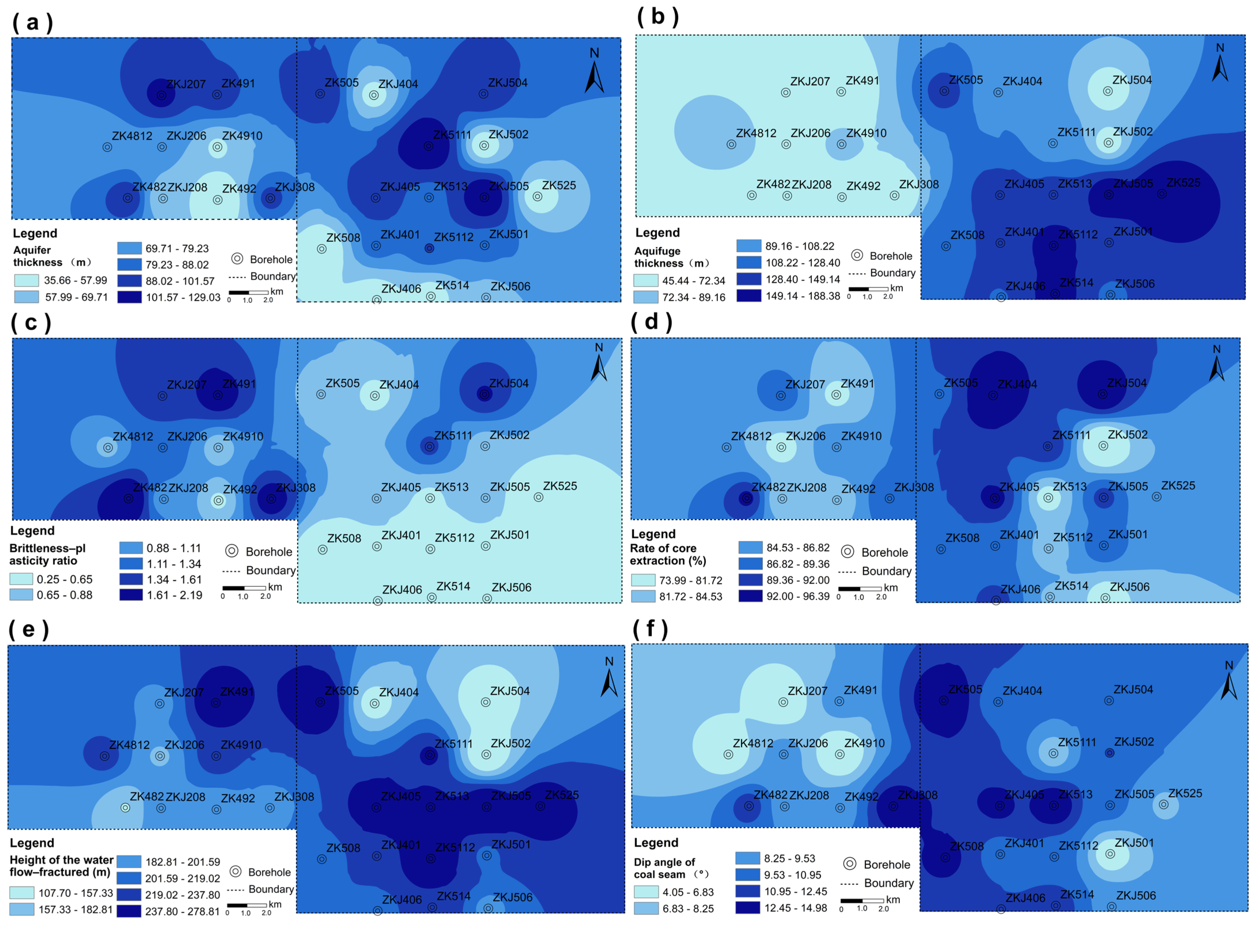
Combining the experience of previous scholars and the geological and hydrological report information provided by the mine, six factors such as the height of the water flow–fractured zone, the dip angle of the coal seam, the thickness of the water–bearing layer, the thickness of the confining bed, the brittleness–plasticity ratio, and the rate of core extraction were selected as the primary control factors for water inrush in the roof of Coal Seam No. 7, considering the rock structure of the mine and the disturbance of coal seam mining. Then, the GIS was used to create a thematic map of the six factors that influence the generation of water bursts in the coal seam roof based on our quantitative analysis of their impact (see Figure 4). The map’s left part shows Area I, and the right side shows Area II.

3.1.1. Rock Fabric Formation Factors

(1)
Aquifer thickness. The arenaceous rock layer’s thickness is a critical factor affecting an aquifer’s water richness. Sandstone has a good permeability and a high porosity: the greater its thickness, the greater its water–holding capacity, and the greater the water richness of the aquifer [22]. Therefore, the thickness of sandstone in the fracture zone indicates the aquifer’s water richness. From Figure 4a, it can be observed that the aquifer’s thickness is greater in Area I and in the upper section of Area II.
(2)
Aquifuge thickness. Mudstone and sandy mudstone, which are plastic rocks, typically exhibit low levels of strength and hardness but possess excellent plasticity and sealing properties [23]. Therefore, the cumulative thickness of plastic rocks in the caving zone indicates their water barrier strength. From Figure 4b, it can be seen that the thickness of the confining bed is greater in the middle of Area II.
(3)
Brittleness–plasticity ratio. The brittleness–plasticity ratio can reflect the mechanical properties and stability of the entire rock formation. Generally speaking, brittle rocks are more prone to breakage and fracture, while plastic rocks are more likely to deform and slide. Therefore, a roof with a sizeable brittleness–plasticity ratio is more likely to crack and fracture during mining, resulting in an increased risk of roof water inrush [24]. From Figure 4c, it can be seen that the western part of Area I exhibits a higher brittleness–plasticity ratio, while Area II has a relatively consistent brittleness–plasticity ratio.
(4)
Rate of core extraction. The rate of core extraction refers to the ratio of the actual core length to the drilling length during the drilling process. Through core observation, we can evaluate the stability of the top slab by analyzing its integrity, lithological changes, and fracture development. A higher core sampling rate typically indicates a more complex and less stable top slab structure, which increases the likelihood of water inrush. Conversely, a lower rate indicates a reduced chance of this phenomenon [25]. Figure 4d shows that the high core extraction rate is mainly concentrated in the central parts of Area I and Area II.

3.1.2. Mining Disturbance Factors

(1)
Height of the water flow–fractured zone. As the thickness of the mined coal seam increases, so does the height of the water flow–fractured zone. This increases the likelihood of intersecting with the overlying aquifer and causing severe water inrush [26].
Statistics reveal the drilling data of Coal Seam No. 7: the thickness of the pure coal is 7.66–17.92 m, with an average of 11.18 m, and the caving mining method is adopted in this mine. Existing formulas for calculating the height development of the diversion fissure zone do not apply to the integrated coal release caving mining method. Additionally, measurements of the height development of the “two zones” of Jurassic coal seams in Xinjiang are scarce [27]. Therefore, drawing on measured data from the height development of diversion fissure zones in other Jurassic coal fields in mainland China, this study calculates the cracking ratio for the soft top layer to be 15 times.
(2)
Dip angle of the coal seam. Generally, a larger coal seam inclination results in stronger sliding pressure and tension during mining. This increases the disturbance to the roof and the rated stresses on the overlying coal seam, making the roof’s rock more prone to misalignment and fragmentation, leading to water inrush [28]. Figure 4f shows that the upper–left coal seam dip angle of Area II is relatively large.

3.2. Determination of the Influence Weight of Each Main Control Factor

3.2.1. Analytic Hierarchy Process

The analytic hierarchy process (AHP) is a method of multi–criteria decision analysis that breaks down complex decision problems into multiple objectives or criteria and further divides them into hierarchical indicators. Experts use their experience to determine the importance between parts, resulting in a decision matrix which defines the weights of each factor [29,30].
A hierarchical structure model was established in our research by analyzing the main factors controlling the roof water inrush of Coal Seam No. 7. The model’s objective (A) was the risk assessment of roof water inrush in Coal Seam No. 7, with rock fabric formation factors (B1) and mining disturbance factors (B2) as the model’s criteria layers (B level). The specific indicator data of the thickness of the water–bearing layer (C1), the thickness of the water barrier (C2), the brittleness–plasticity ratio (C3), the Rate of core extraction (C4), the height of the water flow–fractured zone (C5), and coal seam inclination (C6) served as the model’s decision layer (C level). The judgment matrix (see Table 1, Table 2 and Table 3) was obtained by scoring the importance of each factor by experts, which was calculated to satisfy the consistency test of CR < 0.1, and the weights of each index were obtained.

3.2.2. Entropy Method

The entropy method is a decision–making approach that uses information entropy to evaluate multiple attributes. A lower entropy means more information and less uncertainty, while a higher entropy means less information and more luck. It can be more objective, scientific, and effective in dealing with multi–attribute decision–making problems than other methods [31,32].
The entropy method determines weights through the following steps: (1) Normalize data: The original data need to be standardized or normalized to eliminate the impact of data dimensions and distribution ranges. (2) Calculate probability distribution: Calculate the relative proportion of each indicator in the evaluation object, that is, the probability distribution. (3) Calculate information entropy: Based on the probability distribution, calculate the information entropy of each indicator. (4) Calculate information entropy redundancy: Information entropy redundancy reflects the importance of indicators, that is, one minus the corresponding information entropy value. (5) Determine weights: The result of dividing the information entropy redundancy of each indicator by the sum of all indicator information entropy redundancies is the weight of each indicator.
The weights obtained by the two methods are shown in Table 4.

3.2.3. Game Theory Combination Weighting

The basic idea of game theory is to find an equilibrium point of conflict and compromise between the participants of a game that maximizes the gains of each party. It can be used to determine the weights of indicators and construct a game empowerment model to balance the advantages of multiple empowerment methods and rationalize the objectivity and scientificity of the weights of the indicators. The game theory combination assignment method aims to find the optimal combination of solutions among the combination of weights obtained by different methods, minimizing the deviation between the optimal combination of solutions and the weights.
This paper used subjective and objective weighting methods and game theory to aggregate their weight sets to improve the scientific nature of attribute weight assignment and reduce subjectivity. The relationship between the evaluation conclusions corresponding to different evaluation methods in conflict coordination is studied to seek their equilibrium results. This can solve the problem of determining weights more scientifically, comprehensively, and objectively than other methods [33,34].
Using M methods to assign weights to attributes results in M weight vectors, forming a set w = { ω 1   , ω 2   , , ω m } . The linear combination of these vectors is denoted as follows:
W = k = 1 m α k · w k T         k = 1,2 m
The game theory aggregation model aims to achieve a coordinated state through environmental settings, allowing different evaluation methods to reach a fair and reasonable result. Therefore, the linear combination formula αk is optimized to minimize the deviation between W and wk. The objective function of the model is the following:
Min k = 1 m α k · w k T w k T 2           k = 1,2 m
where αk is the weight coefficient, and wk is the set of basic weight vectors.
The first–order derivative condition for optimizing the equation using matrix differentiation is as follows:
k = 1 m α k · w k · w k T = w k · w k T             k = 1,2 m
The above is converted to a system of linear equations:
w 1 · w 1 T w 1 · w 2 T · w 1 · w m T w 2 · w 1 T w 2 · w 2 T · w 2 · w m T · · · · w m · w 1 T w m · w 2 T · w m · w m T α 1 α 2 · α m = w 1 · w 1 T w 2 · w 2 T · w m · w m T                
The linear combination coefficients α 1 ,   α 2 , , α m obtained from the above formula are normalized to finally obtain the comprehensive weight W based on the game theory combination weighting method:
W = α 1 * w 1 T + α 2 * w 2 T + + α m * w m T    
        α m * = α k k = 1 m α k    
From Formulas (1), (3), (5), and (6), it can be concluded that the AHP and entropy weight method coefficients used in this paper are α 1 * α 2 * = 0.5354 0.4646 , and the comprehensive weights are shown in Table 5.

3.3. Compatibility Test

In order to compare the reliability of u kinds of assignment methods, in the literature, Spearman’s grade correlation coefficient is introduced to calculate the superiority judgment of the methods, and it is usually considered that, the larger the compatibility degree is, the better this assignment method is. From Equation (7), the compatibility degree of the x–th assignment method can be obtained:
    r x = 1 u 1 y = 1 u r x , y   ,   x = 1,2 , , u   ,   x y  
r x , y = 1 6 v 3 v i = 1 v a i x a i y 2   ,       x , y = 1,2 , , u
where (aixaiy) is the difference between the rankings of the ith indicator under both x and y weighting methods.
The compatibility of the AHP method, the entropy method, and the game theory coupled assignment method is calculated to be 0.3571, 0.3285, and 0.4143, respectively, indicating that the game theory coupled assignment method is better than the other two assignment methods.

4. Results

4.1. Normalization of Index Data

The six indicators in this paper have different ranges and require normalization for direct comparison and analysis. In addition, normalized data have a similar range and distribution, making exploratory data analysis and visualization more convenient [35].
Normalization:
X i = x i min ( x i ) max x i min ( x i )     ( i = 1,2 , n )
Reverse Normalization:
X i = max ( x i ) x i max x i min ( x i )     ( i = 1,2 , n )
In the formula, x i is the original data before normalization; max ( x i ) and min ( x i ) are the maximum and minimum values of the quantized values of each index, respectively.

4.2. Risk Zoning and Evaluation

Using the ArcGIS spatial composite overlay function, each index’s weights and normalized data were overlaid to create an evaluation model, and the reclassification method with natural interruption points was then used to grade the model further:
ξ = C 1 ω 1 + C 2 ω 2 + C 3 ω 3 + C 4 ω 4 + C 5 ω 5 + C 6 ω 6
where ξ is the water inrush index; C1, C2, C3, C4, C5, C6 are the standardized data of various factors; and ω is the standardized weight in different ranges.
Based on the grading threshold, the study area was divided into five areas: I (safe area, 0.27–0.40), II (relatively safe area, 0.40–0.45), III (transitional area, 0.45–0.51), IV (less fragile area, 0.51–0.57), and V (fragile area, 0.57–0.67), as shown in Figure 5. The dangerous zone is mainly located in Area I of the mine, while Area Ⅱ mostly consists of safe and safer zones.

5. Discussion

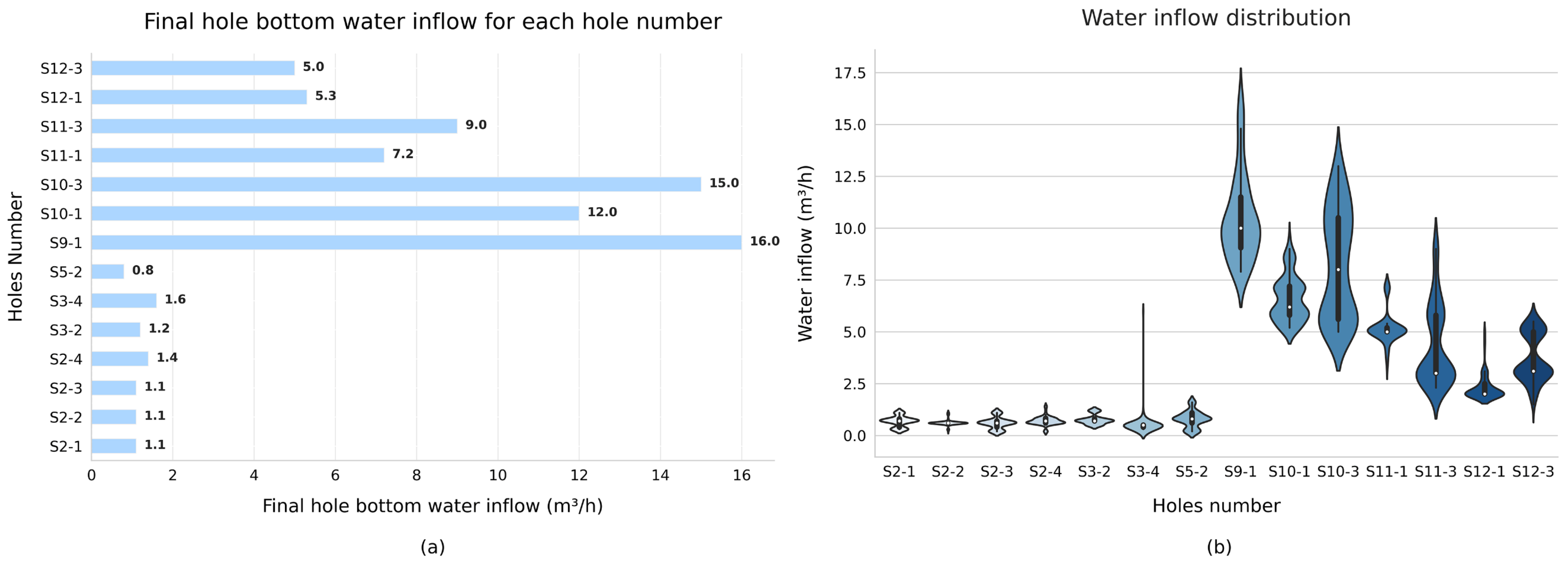
To verify the reliability of the hazard zoning results, this study conducted validation using the observed water inflow data from the 11,604 and 11,701 working–face roof boreholes. Generally, downhole water exploration and drainage drilling are conducted before the mining of the working face. The final hole is located in the range of the water–conducting fracture zone of the roof. The main purpose is to explore the abnormal water richness area of the roof (the area with a high risk of water inrush) and drain the water in advance. According to the change in water inflow in each hole with time, we can understand the distribution of water richness of each aquifer in the top plate of the coal seam, which is favorable for evaluating water inrush risk. Since the height of the water flow–fractured zone caused by the mining of Coal Seam No. 7 will affect Coal Seams No. 3 and 5(6), Areas I and II can be considered dangerous throughout the entire area. Figure 6a shows the final hole bottom water inflow of each hydrophobic borehole, while Figure 6b displays the distribution and probability of water inflow over time for each hydrophobic hole, showing the distribution of water enrichment in each aquifer above the coal seam during drilling.
According to the water inrush observation data, the 16 hydrophobic holes in Area I, i.e., SF–1 and SF–2, had the highest final water yield, at 79 m3/h and 75.3 m3/h, respectively (not shown in the figure). The remaining hydrophobic holes with a final hole bottom water inflow greater than 2 m3/h were all located in the dangerous or more dangerous zones. The water inflow of hydrophobic holes S2–1 to S2–4 was mainly around 1.1 m3/h, with S3–4 having a momentary water inflow of about 7 m3/h, but the overall water yield was still below 2 m3/h, meaning that these hydrophobic holes were located in the transitional area. Hydrophobic hole S5–2 had the most negligible final water inflow, of only 0.8 m3/h, and was located in the safer zone, with an overall water inflow below 2 m3/h. Overall, the water inflow of these 16 hydrophobic holes was consistent with the hazard zoning results.
Therefore, the roof water inrush hazard zoning obtained by overlaying the above–discussed six evaluation indices with weights suitable for the conditions of this mine area was consistent with the actual situation. The accuracy of the evaluation results was high and could provide a reference for the roof drainage scheme in Area II.

6. Conclusions

(1)
According to the complex mining geological conditions of Dananhu Coal Mine No. 7, the height of the water flow–fractured zone, the aquifer thickness, the aquifuge thickness, the brittleness–plasticity ratio, the rate of core extraction, and the dip angle of the coal seam were selected as the leading causes of water inrush against the roof control factors of Coal Seam No. 7th.
(2)
The AHP and entropy methods were used to determine the subjective and objective weights. Game theory analysis was used to coordinate the competitive yet consistent relationship between the two evaluation methods, obtaining the combined weights of each influencing factor and compensating for the shortcomings of a single weighting method, and the final prediction results were more realistic. According to the final results, the dangerous zone is mainly located in the Area I of the mine, while Area II mostly consists of safe and safer zones; therefore, there is a greater possibility of roof water inrush occurring during the mining of Coal Seam No. 7 in Area I, which requires greater attention.
(3)
The roof water inrush hazard zoning obtained by overlaying the above–discussed six evaluation indices with weights suitable for the conditions of this mine area is consistent with the actual situation. The accuracy of the evaluation results is high, which means that this method can be used for hydrological assessment of coal mines with similar geological conditions.

Author Contributions

This article was written by Q.L., Q.W. and J.X., who jointly carried out the research design and data analysis. Q.L., J.X., Q.W. and W.L. contributed to the writing and revision of this article, providing constructive feedback and suggestions to ensure an accurate representation of the complex research findings. All authors have read and agreed to the published version of the manuscript.

Funding

This work was supported by the National Natural Science Foundation of China (Grant No. 42007240) and the project “Enlisting and Leading” of China Coal (No. 2022JB01).

Data Availability Statement

The datasets used or analyzed during the current study are available from the corresponding author upon reasonable request.

Acknowledgments

The authors express their gratitude to everyone that provided assistance for the present study.

Conflicts of Interest

Author Qingtao Liu was employed by the company China Coal Group Xinjiang Energy Co., Ltd. The remaining authors declare no conflicts of interest.

References

  1. Bukowski, P. Water Hazard Assessment in Active Shafts in Upper Silesian Coal Basin Mines. Mine Water Environ. 2011, 30, 302–311. [Google Scholar] [CrossRef]
  2. Zhang, P.; Dong, Y.; Zhang, X.; Xu, D. Statistical law analysis and forecast of coal mine water disaster accidents in China from 2008 to 2021. Coal Eng. 2022, 54, 131–137. [Google Scholar]
  3. Jin, D.; Liu, Y.; Liu, Z.; Cheng, J. New Progress of Study on Major Water Inrush Disaster Prevention and Control Technology in Coal Mine. Coal Sci. Technol. 2013, 41, 25–29. [Google Scholar] [CrossRef]
  4. Zhang, R.; Jiang, Z.; Zhou, H.; Yao, C.; Xiao, S. Groundwater outbursts from faults above a confined aquifer in the coal mining. Nat. Hazards 2014, 71, 1861–1872. [Google Scholar] [CrossRef]
  5. Yin, S.; Zhang, J.; Liu, D. A study of mine water inrushes by measurements of in situ stress and rock failures. Nat. Hazards 2015, 79, 1961–1979. [Google Scholar] [CrossRef]
  6. Liu, X.; Wang, S. Mine Water Inrush Forecasting during the Mining under Waters. Disaster Adv. 2012, 5, 876–881. [Google Scholar]
  7. Mao, H.; Liu, Z.; Deng, C.; Wang, D. Discussion of forecasting methods for coal mining water–inrush. Hebei J. Ind. Sci. Technol. 2008, 25, 4. [Google Scholar]
  8. Wang, G.; Wang, X.; Li, j.; Huang, B.; Cheng, S.; Zhao, C.; Liu, G. Identification model of gushing water sources in Pingdingshsn coal mines. Coal Geol. Explor. 1998, 26, 48–51. [Google Scholar]
  9. Liu, Y.; Qiu, H.; Kamp, U.; Wang, N.; Wang, J.; Huang, C.; Tang, B. Higher temperature sensitivity of retrogressive thaw slump activity in the Arctic compared to the Third Pole. Sci. Total Environ. 2024, 914, 170007. [Google Scholar] [CrossRef]
  10. Wu, Q.; Huang, X.; Dong, D.; Yin, Z.; Li, J.; Hong, Y.; Zhang, H. “Three maps–two predictions” method to evaluate water bursting conditions on roof coal. J. China Coal Soc. 2000, 2000, 62–67. [Google Scholar] [CrossRef]
  11. Wu, Q.; Liu, Y.; Zhou, W.; Li, B.; Zhao, B.; Liu, S.; Sun, W.; Zeng, Y. Evaluation of water inrush vulnerability from aquifers overlying coal seams in the menkeqing coal mine, China. Mine Water Environ. 2015, 34, 258–269. [Google Scholar] [CrossRef]
  12. Zeng, Y.; Wu, Q.; Liu, S.; Zhai, Y.; Lian, H.; Zhang, W. Evaluation of a coal seam roof water inrush: Case study in the Wangjialing coal mine, China. Mine Water Environ. 2018, 37, 174–184. [Google Scholar] [CrossRef]
  13. Zhang, J.; Yang, T. Study of a roof water inrush prediction model in shallow seam mining based on an analytic hierarchy process using a grey relational analysis method. Arab. J. Geosci. 2018, 11, 153. [Google Scholar] [CrossRef]
  14. Fan, G.; Zhang, S.; Zhang, D.; Zhang, C.; Chen, M.; Li, Q. An Index of Aquiclude Destabilization for Mining–Induced Roof Water Inrush Forecasting: A Case Study. Water 2019, 11, 2170. [Google Scholar] [CrossRef]
  15. Ruan, Z.; Li, C.; Wu, A.; Wang, Y. A New Risk Assessment Model for Underground Mine Water Inrush Based on AHP and D–S Evidence Theory. Mine Water Environ. 2019, 38, 488–496. [Google Scholar] [CrossRef]
  16. Sun, Z.; Bao, W.; Li, M. Comprehensive Water Inrush Risk Assessment Method for Coal Seam Roof. Sustainability 2022, 14, 10475. [Google Scholar] [CrossRef]
  17. Yu, W.; Qian, J.; Ma, L.; Zhao, W.; Zhou, X. The water inrush risk assessment of roof of seam 13–1 in Xieqiao mine based on GIS and AHP. Coal Geol. Explor. 2016, 44, 69–73. [Google Scholar]
  18. Yin, H.; Shi, Y.; Niu, H.; Xie, D.; Wei, J.; Lefticariu, L.; Xu, S. A GIS based model of potential groundwater yield zonation for a sandstone aquifer in the Juye Coalfeld, Shandong, China. J. Hydrol. 2018, 557, 434–447. [Google Scholar] [CrossRef]
  19. Lu, Q.; Li, X.; Li, W.; Chen, W.; Li, L.; Liu, S. Risk Evaluation of Bed–Separation Water Inrush: A Case Study in the Yangliu Coal Mine, China. Mine Water Environ. 2018, 37, 288–299. [Google Scholar] [CrossRef]
  20. Li, B.; Wei, T.; Liu, Z. Construction of evaluation index system for water abundance of karst aquifers and risk assessment of water inrush on coal seam roof in Southwest China. J. China Coal Soc. 2022, 47, 152–159. [Google Scholar] [CrossRef]
  21. Xu, Z.; Gao, S.; Cui, S.; Sun, Y.; Chen, Z.; Wu, J. Hydro–geological basic and practice for water–preserved mining in ecologically vulnerable area: A case study in Hami coalfield. J. China Coal Soc. 2017, 42, 80–87. [Google Scholar] [CrossRef]
  22. Ding, H.; Zhan, R.; Li, H.; Sun, G.; Chen, X.; Gu, C. Risk assessment of water inrush from roof of 11–2 coal seam in Xinji Mining Area based on AHP and GIS. Coal Sci. Technol. Mag. 2022, 43, 87–93. [Google Scholar]
  23. Xie, D.; Han, J.; Zhang, H.; Wang, K.; Du, Z.; Miao, T. Risk Assessment of Water Inrush from Coal Seam Roof Based on Combination Weighting–Set Pair Analysis. Sustainability 2022, 14, 11978. [Google Scholar] [CrossRef]
  24. Wang, Y.; Jiang, J. The application of the ratio on brittle and tenacity terrane in the analysis of causes of fault formation. J. Henan Polytech. Univ. 2001, 2001, 342–346. [Google Scholar]
  25. Feng, S.; Wu, Q. Research on water—Richness of aquifer using comprehensive weight method based on AHP and variation coefficient. Coal Eng. 2016, 48, 138–140. [Google Scholar]
  26. Zhang, S.; Tang, S.; Zhang, D.; Fan, G.; Wang, Z. Determination of the Height of the Water–Conducting Fractured Zone in Difficult Geological Structures: A Case Study in Zhao Gu No. 1 Coal Seam. Sustainability 2017, 9, 1077. [Google Scholar] [CrossRef]
  27. Liu, S.; Li, W.; Wang, Q. Height of the Water–Flowing Fractured Zone of the Jurassic Coal Seam in Northwestern China. Mine Water Environ. 2018, 37, 312–321. [Google Scholar] [CrossRef]
  28. Qu, W.; Li, B.; Li, H.; Niu, L. Study on Risk Assessment Methods for Coal Seam Roof Water Disaster in Southwestern Karst Area Based on Fuzzy Analytical Hierarchy Process. Min. Saf. Environ. Prot. 2014, 41, 59–62. [Google Scholar]
  29. Rezaei, J. Best–worst multi–criteria decision–making method. Omega–Int. J. Manag. Sci. 2015, 53, 49–57. [Google Scholar] [CrossRef]
  30. Xiao, L.; Fan, L.; Chao, N.; Dai, L.; Qian, Q.; Lin, C. Evaluation of Water Inrush Hazard in Coal Seam Roof Based on the AHP–CRITIC Composite Weighted Method. Energies 2023, 16, 114. [Google Scholar] [CrossRef]
  31. Liu, W.; Sun, Q.; Xu, B. Risk Evaluation of Water Inrush from Coal Seam Floor Based on GIS and Principal Component Analysis Entropy Weight Method. Min. Res. Dev. 2020, 40, 83–88. [Google Scholar] [CrossRef]
  32. Xue, J.; Shi, L.; Wang, H.; Ji, Z.; Shang, H.; Xu, F.; Zhao, C.; Huang, H.; Luo, A. Water abundance evaluation of a burnt rock aquifer using the AHP and entropy weight method: A case study in the Yongxin coal mine, China. Environ. Earth Sci. 2021, 80, 417. [Google Scholar] [CrossRef]
  33. Omrani, H.; Shafaat, K.; Emrouznejad, A. An integrated fuzzy clustering cooperative game data envelopment analysis model with application in hospital efficiency. Expert Syst. Appl. 2018, 114, 615–628. [Google Scholar] [CrossRef]
  34. Peng, J.; Zhang, J. Urban flooding risk assessment based on GIS– game theory combination weight: A case study of Zhengzhou City. Int. J. Disaster Risk Reduct. 2022, 77, 103080. [Google Scholar] [CrossRef]
  35. Yu, X.; Wang, D.; Shi, L.; Meng, M. Water–richness Evaluation Method of Water–filled Aquifer Characteristics Analysis Based on Evaluation Method. Coal Technol. 2016, 35, 152–154. [Google Scholar] [CrossRef]
Figure 1. The location of the Coal Mine No. 7 fields in Dananhu.
Water 16 00710 g001
Figure 2. Schematic diagram of the vertical distribution of the water–bearing (isolated) seam.
Water 16 00710 g002
Figure 3. Flowchart of the methodology used in this study.
Water 16 00710 g003
Figure 4. Thematic diagram of each main control factor. (a) Aquifer thickness; (b) Aquifuge thickness; (c) Brittleness–plasticity ratio; (d) Rate of core extraction; (e) Height of the water flow–fractured zone; (f) Dip angle of the coal seam.
Water 16 00710 g004
Figure 5. Comprehensive zoning evaluation of roof water risk.
Water 16 00710 g005
Figure 6. Water inrush in hydrophobic boreholes. (a) The final hole bottom water inflow of each hydrophobic borehole; (b) The distribution and probability of water inflow over time for each hydrophobic hole.
Water 16 00710 g006
Table 1. Judging matrix A~Bi(1~2).
AB1B2EigenvectorWeightCICR
B111/20.6670.33330none
B2211.3330.6667
Table 2. Judging matrix B1~Ci(1~4).
B1C1C2C3C4EigenvectorWeightCICR
C11231/31.0880.27210.0870.097
C21/2121/20.7500.1874
C31/31/211/20.4990.1248
C432211.6630.4157
Table 3. Judging matrix B2~Ci(5~6).
B2C5C6EigenvectorWeightCICR
C5131.50.750none
C61/310.50.25
Table 4. Weight values of the main controlling factors.
Main Controlling FactorsAquifer
Thickness
Aquifuge
Thickness
Brittleness–Plasticity RatioRate of Core ExtractionHeight of Water Flow–Fractured ZoneDip Angle of Coal Seam
AHP Weight0.09070.06250.04160.13860.50000.1667
Entropy Weight0.18700.09040.40600.15670.05180.1081
Table 5. Comprehensive weight values of the main controlling factors.
Main Control FactorsAquifer
Thickness
Aquifuge
Thickness
Brittleness–Plasticity RatioRate of Core ExtractionHeight of Diversion Fissure ZoneDip Angle of Coal Seam
Comprehensive weight0.13540.07540.21090.14700.29180.1395
Disclaimer/Publisher’s Note: The statements, opinions and data contained in all publications are solely those of the individual author(s) and contributor(s) and not of MDPI and/or the editor(s). MDPI and/or the editor(s) disclaim responsibility for any injury to people or property resulting from any ideas, methods, instructions or products referred to in the content.