Abstract
Water resources are crucial for the development of ecosystems and humanity. The Yellow River Basin (YRB), as an important ecological area in China, is facing significant challenges in ecological protection and high-quality development due to global climate change and intense human activities. In order to alleviate the water resources crisis in the YRB, it is necessary to calculate the resilience of the water resources system and identify the main influencing factors. This paper considered the factors of water resources, social economy, and ecological environment, then constructed an evaluation framework of the water resources system resilience (WRSR) from three aspects: resistance, restoration, and adaptability. Taking nine provinces along the YRB as a case study, the WRSR was measured by using the entropy weight TOPSIS model, and its driving factors were analyzed with Geographical Detectors (GD). The results showed that: (1) From 2010 to 2022, the WRSR in the Yellow River Basin and various provinces was showing a fluctuating increasing trend, in which Ningxia had the highest average WRSR (0.646), while Shanxi had the lowest (0.168). (2) From three dimensions, the development trends of resistance, restoration, and adaptability in the YRB and various provinces from 2010 to 2022 were relatively stable. Shandong’s resistance level far exceeded that of other provinces, having the highest average resistance value (0.692), and Ningxia had the highest average value of restoration (0.827) and adaptability (0.711). However, Gansu had the lowest average value of resistance (0.119), Sichuan had the lowest average value of restoration (0.097), and Shandong had the lowest average value of adaptability (0.110). (3) In terms of impact factors, the development and utilization rate of water resources (C13) and the development and utilization rate of surface water resources (C14) in the restoration subsystem consistently ranked in the top two of influencing factors. Similarly, the water consumption per 10,000 yuan of GDP (C26) in the adaptability subsystem consistently ranked within the top ten. On the other hand, the natural population growth rate (C6) in the resistance subsystem, as well as the impact of ammonia nitrogen emissions (C9) and total precipitation (C2) in wastewater, exhibited an upward trend. Based on these, this paper provides relevant suggestions for improving the WRSR in the YRB.
1. Introduction
Since the beginning of the 21st century, rapid economic development and population growth have led to the consumption of large quantities of water resources. Due to climate change and an increase in the demand for water resources resulting from population growth and urbanization, water shortage has become an obstacle to the sustainable development of the social economy [1,2,3,4,5,6,7]. As a complex system with multiple attributes, the water resources system is composed of various subsystems such as water resources, the social economy, and ecological environment. Due to the dual impact of climate change and human activities, the safety and stability of the water resources system are seriously threatened. Problems such as water scarcity, water ecological damage, water environment pollution, floods, and supply–demand imbalance frequently occur and are intertwined [8,9,10].
In order to cope with related risks, resilience thinking has gradually formed and received attention, that is, the notion that when the water resources system is impacted, we quickly take measures to reduce the influence of the impact, resist and recover from disturbances, and develop the ability to resist risks [11]. It provides new approaches to improve water services and resources management that go beyond disaster risk reduction and management [12]. The concept of resilience originates from the field of physics, namely engineering resilience, which, in a system with a single stability regime, defines resilience as the system’s process of recovery when subjected to impact or disturbance [13]. Holling proposed the concept of ecological resilience in 1973, which assumes that a system may have multiple alternative states and emphasizes that resilience is the magnitude of disturbance that a system can absorb before shifting from one state to another. Holling and Gunderson proposed the adaptive cycle theory in 2002, which suggests that the social ecosystem is always in a constantly changing cycle state, undergoing four successive phases called (a) exploitation, (b) conservation, (c) creative destruction, and (d) reorganization, forming an adaptive cycle with three attributes: potential, connectivity, and resilience [14]. Based on the adaptive cycle theory, Gunderson proposed evolutionary resilience, which places greater emphasis on system evolution and recovery [15]. With the deepening of research, the connotation of resilience has been further deepened. Despite the disparity of the uses of resilience in different fields, the commonality among them is that resilience refers to the ability of a region or a system to resist, recover, adapt, and transform after a shock [16,17,18,19,20], and it has multidimensional characteristics of resistance, restoration, and adaptability [21].
Water resources system resilience (WRSR) refers to the ability of regional water resources systems to resist damage or quickly recover from uncertainties such as natural disasters and economic crises [22,23,24]. This process has three stages: (1) Pre-disturbance, a system’s resistance to disturbance and risk (resistance). At this time, the impact on WRSR is mainly composed of two parts: external pressure and internal pressure. External pressure mainly includes the increased frequency of natural disasters against the background of climate change. Internal pressure refers to endogenous problems involving resources and the environment caused by human activities’ instability and accumulation effect [24]. This paper uses indicators of regional water resources availability, population pressure, and sewage discharge to measure the resistance. (2) Under-disturbance: the water resources system is damaged, and through self-adjustment, learning and summarizing experience, and reducing losses, the system can quickly recover to its initial state or even higher resilience levels (restoration). The main consideration is the impact of internal factors such as the development and utilization rate of water resources, industrial structure, and ecological environment quality. (3) Post-disturbance: the system needs to make an adaptive adjustment and continuously improve its adaptability. The adaptation process of WRSR is mainly influenced by regional innovation factors, security factors, etc. It mainly considers factors such as water resources matching coefficient, economic development level, and ecological environment investment. Its adaptability level determines the new level of resilience that the system can migrate to under the next impact.
Regarding the research on WRSR, scholars mainly focus on establishing basic theories, proposing measurement methods, and exploring strategies, and have conducted a large amount of research [25,26,27,28]. However, research on WRSR is mostly limited to quantitative analysis and evaluation of water resources resilience itself, ignoring its connection with social, economic, ecological, and environmental factors. Water resources utilization, social economy development, and ecological environment protection are key factors for regional sustainable development [29,30,31,32]. In order to achieve sustainable development, it is necessary to balance social and economic needs with the protection of the ecological environment through scientific water resources management and effective policy measures.
At present, there are three main methods for measuring WRSR. The first method is the indicator system method, which first establishes an indicator system, and then uses quantitative methods such as entropy weight method, variable fuzzy set, intelligent algorithm, etc., to evaluate the resilience level. Zhou [33] used the entropy weight method to calculate the level of WRSR in 11 provinces and cities in the Yangtze River Basin based on the process attributes of resilience and its logical correlation with the PSR model. An [34] constructed an “economy-social development-infrastructure-water resources-ecological environment” WRSR assessment framework from three stages: resistance, resilience, and adaptability. Sun and Meng [35] further improved the evaluation index system of WRSR, taking into account culture, system, and other “soft power” factors. Zhao [36] constructed the evaluation index system for WRSR from three dimensions: resistance, restoration, and adaptability. Additionally, a two-level fuzzy comprehensive evaluation method was used to evaluate the level of WRSR in Zhengzhou City. The second method is model simulation, which uses mathematical models to simulate the performance level of WRSR under different scenarios. Stojkovic [37] constructed an assessment framework for WRSR based on system dynamics and neural networks, and evaluated the WRSR under harmful events through steps such as data collection, model construction, training, and testing. Liu [38] simulated the dynamic development process of water resources systems using correlation methods, and then evaluated the dynamic process of regional WRSR through dynamic analysis of resilience paths. Yang [39] applied the three-way decision-making method to evaluate WRSR through scenario construction, decision analysis, and decision selection. The third method is the comprehensive evaluation method, which combines advantages of the indicator system method and model simulation method to comprehensively evaluate WRSR. Herrera-Franco [40] constructed a groundwater resilience assessment framework based on the indicators in the social hydrological framework and sustainable development goals, and constructed a resilience assessment matrix to comprehensively evaluate the groundwater resilience in the Manglaralto region of Ecuador. Liu [41] constructed an evaluation index system for agricultural water resources system resilience from multiple aspects such as water quantity, water quality, water resources allocation, and water resources management. The Support Vector Machine (SVM) method was used to classify and identify the characteristics of resilience in an agricultural water resources system.
After sorting out relevant research, it has been found that there are still some gaps in the current research on WRSR: (1) In defining the connotation of WRSR, it mostly starts from the perspective of resources factors, and fails to fully consider the relationship between water resources systems and natural resources, socio-economic, ecological environment, and other systems; (2) In terms of the evaluation framework for the WRSR, insufficient consideration has been given to the complexity of water resources systems, and the factors considered in the selection of indicators need to be improved; and (3) There is a lack of exploration of the identification and regulation factors of the spatial and temporal pattern of WRSR, and the practicality of policy recommendations needs to be strengthened.
Therefore, in this paper, an evaluation index system for WRSR was constructed based on the resistance, restoration, and adaptability dimensions, considering the effects of water resources, social economy, and ecological environment. The entropy weight TOPSIS method was used to measure the WRSR in the Yellow River Basin from 2010 to 2022. Then, ArcGIS was used to analyze spatial differentiation features, and finally apply factor detection was used to identify the main driving factors affecting the level of WRSR. The research in this paper can provide a certain theoretical basis and reference for future study on WRSR evaluation methods. There are three main innovations in this paper: (1) This paper constructed a WRSR evaluation framework from three dimensions—resistance, restoration, and adaptability—which provided a new way of thinking for WRSR research. (2) We considered the human–water system, taking into account factors such as water resources, social economy, and ecological environment, then studying the development trends of WRSR in the Yellow River Basin. (3) We analyzed the spatial and temporal distribution characteristics of WRSR and recognized the driving factors.
However, this paper also has the following research limitations. On the one hand, due to the complexity and dynamism of resilience theory, the indicator system constructed in this article still needs to be improved through further research. On the other hand, as the selection of indicators only considers quantitative indicators and lacks the measurement of qualitative indicators, future analysis needs to consider both qualitative and quantitative indicators comprehensively to reflect the level of resilience more comprehensively.
2. Materials and Methods
2.1. Study Area
The Yellow River Basin (YRB) is an important distribution area of water resources in China, flowing through nine provinces and regions including Qinghai, Sichuan, Gansu, Ningxia, Inner Mongolia, Shaanxi, Shanxi, Henan, and Shandong [42,43]. It has a total length of about 5464 km and a drainage area of 795,000 km2 carrying capacity supporting 12.5% of the country’s population. It is an important water supply source in the northwestern and northern regions of China. The location of the Yellow River Basin is shown in Figure 1.
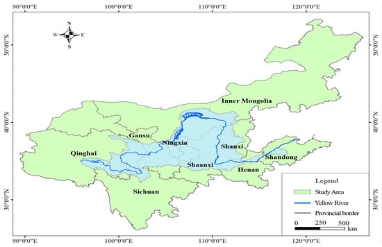
Figure 1.
The YRB and nine provinces.
The majority of the YRB is located in arid and semi-arid areas, which have a fragile ecological environment and are sensitive areas to climate change in China [44]. In the context of climate change, the situation of water resources security in river basins is severe, the ecological environment is fragile, flood risk is the biggest threat to the basin, and the quality of development needs to be improved. On the other hand, frequent floods and droughts pose increasing risks and severe challenges to socio-economic development and people’s lives. The ecological function of natural grasslands in the upper reaches of the area has degraded, and the water conservation function has decreased. The restoration of vegetation in the middle reaches leads to a decrease in runoff, approaching the upper limit of water carrying capacity. Ecological changes in the lower reaches include shrinkage of estuarine and delta wetlands, degradation of ecosystems, and weakened overall connectivity of watershed ecosystems [45]. In addition, the YRB is approximately 27 percent of China’s total water resources per capita. The development and utilization rate of surface water resources is as high as 80%, far exceeding the ecological warning line of 40% [46,47]. Extensive overuse of water resources has become the key to restricting high-quality economic development in the YRB. Further, the YRB has a high population density, wide distribution of industry and agriculture, and intensive human activities. The utilization of water resources is facing problems such as insufficient supply of water resources, high development and utilization intensity, sharp increases in water demand, and low utilization efficiency, which seriously restrict development in the region [48]. Therefore, it is necessary to study the WRSR in this area, analyze the relationship between water resources, social economy, and ecological environment, explore important factors that affect its development, and propose relevant suggestions for promoting high-quality development in the YRB.
2.2. Research Methods
Based on the concept of WRSR, considering the three factors of water resources, social economy, and ecological environment, an evaluation index system for the WRSR in the YRB was constructed from three dimensions: resistance, restoration, and adaptability. The conceptual diagram of WRSR is shown in Figure 2.
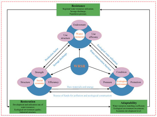
Figure 2.
Conceptual diagram of WRSR.
Then, the entropy weight TOPSIS method was used to calculate the value of the WRSR in the YRB from 2010 to 2022, and ArcGIS was used to analyze the development trends of WRSR in the YRB at both the overall and provincial scale from a spatio-temporal perspective. Finally, factor detection in geographic detectors was used to identify the driving factors that affect the level of the WRSR. The specific research framework is shown in Figure 3.
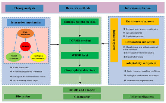
Figure 3.
Research Framework.
2.2.1. Construction of Evaluation Index System
This paper constructs the WRSR through the word frequency analysis from Citespace 6.2.6 software and previous relevant research [49,50,51,52,53]. Having fully considered the development level of water resources, social economy, and ecological environment in the YRB, we constructed an evaluation index system for the WRSR in the YRB from three aspects of resilience development: resistance, restoration, and adaptability. The target layer is the WRSR, the criterion layer is resistance, restoration, and adaptability, and the indicator layer mainly considers factors such as water resources, social economy, and ecological environment. There are a total of 30 evaluation indicators (see Table 1).

Table 1.
Evaluation Index System of WRSR in the YRB.
Based on previous studies [53,54], the evaluation level of WRSR in this research was divided into four grades: very low level (0~0.30), low level (0.30~0.50), high level (0.50~0.70), and very high level (0.70~1.00), as shown in Table 2.

Table 2.
Water Resources System Resilience classification.
2.2.2. An Evaluation Model for WRSR
The entropy weight TOPSIS method combines the entropy weight method and TOPSIS evaluation [55]. On the basis of data standardization, the entropy weight TOPSIS method assigns weights to indicators based on the degree of dispersion of the data, and then uses the TOPSIS method to calculate the distance between all indicator values of each evaluation object and the optimal and worst solutions, thereby obtaining the comprehensive evaluation index over the years [56]. The specific steps are as follows:
(1) Data normalization processing. In order to eliminate differences in the magnitudes of positive and negative indicators, an extreme value standardization method is used to standardize the original indicators. The calculation formula is:
For the bigger, the better (sensitivity) indicators:
For the smaller, the better (sensitivity) indicators:
In Equations (1) and (2), Cij is the evaluation index of the WRSR in the YRB, and Ci is the actual value of the index in year j; Cmax and Cmin are the maximum and minimum values of the evaluation indicators, respectively; and Cij* is the normalized value of Cij, Cij*∈[0, 1].
(2) A standardized evaluation matrix can be obtained after processing.
(3) An entropy weighted decision matrix is constructed. Firstly, the entropy weight method is used to determine the indicator weight W (as this method is more mature, it will not be repeated in this article). We combine the standard evaluation matrix C and entropy weight wi of water resources system resilience in the Yellow River Basin to obtain the standardized evaluation matrix U based on entropy weight.
(4) Next, the TOPSIS method is used to determine the positive ideal solution and negative ideal solution of the entropy weight normalized evaluation matrix.
Positive ideal solution:
Negative ideal solution:
In the formula, and in Formulas (5) and (6) are the maximum and minimum values in the normalized evaluation matrix solution of entropy weight in the j-th year.
(5) TOPSIS method is used to determine the distance between the index at different times and the positive and negative ideal solutions.
The distance from it to the positive ideal solution:
The distance from it to the negative ideal solution:
(6) The comprehensive evaluation score is calculated.
In the Formula (9), Oj is the comprehensive evaluation index of WRSR of YRB in the year j, and its range is [0, 1]. If the value of Oj is larger, it indicates that the overall effectiveness of the WRSR in the region is better, and vice versa, the effectiveness is worse. When Oj approaches 1, that is, this type of indicator in the region tends to be closer to the positive ideal solution of the indicator, indicating that the WRSR is optimal, and the overall level of all aspects has reached the expected goal. When Oj approaches 0, this type of indicator in the region trends towards the negative ideal solution of the indicator, indicating that WRSR is the worst, and the overall level of all aspects has not reached the expected goal.
2.2.3. Geographic Detectors
In order to explore the similarity of the WRSR in spatial distribution, factor detection in geographic detectors is selected to measure the resilience regulation factors and their magnitude in a water resources system. The specific calculation formula is as follows:
In the formula, h = 1,2, …, L is the indicator classification, and the natural fracture point method in ArcGIS 10.8 is used to divide each detection factor into three layers: high, medium, and low; Y is the resilience evaluation value of the water resources system, Nh is the number of evaluation indicators of the WRSR, and N is the number of evaluation units; and are the variances of the indicator layer h and the entire region Y values, respectively. The larger the q value, the greater the contribution of regulatory factors to the WRSR, and the more significant the spatial differentiation of the WRSR.
2.3. Data Source
This study utilized annual panel data for nine provinces and regions in the YRB from 2010 to 2022. The water resources, social economy, and ecological environment data of the nine provinces and regions in the YRB used in this article mainly come from the Water Resources Bulletin of the nine provinces and regions from 2010 to 2022, the National Economic and Social Development Statistical Bulletin of the nine provinces and regions from 2010 to 2022, and the China Statistical Yearbook from 2010 to 2022.
3. Results
3.1. Assessment of WRSR in the YRB
3.1.1. Assessment of the Overall and Provincial Scale of WRSR in the YRB
From Figure 4, we can see that the WRSR in the YRB overall and in the provinces showed a fluctuating and increasing trend, while Ningxia and Shanxi showed a fluctuating but decreasing trend. Ningxia had a high level of overall WRSR, which was always in the first position, while Shanxi was always in the last position. Ningxia had a high natural population growth rate and the per-capita water supply was always in the first position; the proportion of the tertiary industry showed an increasing trend, while the proportion of the secondary industry and the proportion of the primary industry showed a fluctuating decreasing trend; the ecological water consumption rate increased year by year, and the urban sewage treatment rate showed a fluctuating increasing trend, the COD emission in wastewater and ammonia and nitrogen emission in wastewater were both lower, and the investment in wastewater treatment that accounts for a proportion of the GDP was always in the first position.
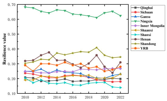
Figure 4.
Trend of WRSR value in the YRB overall and at the provincial scale.
As for Shanxi Province, its water resources endowment was relatively poor, i.e., per-capita water resources, per-capita water supply, and total precipitation were low, while the development and utilization rates of water resources, including surface water resources and groundwater resources, were high. However, fluctuations in the trends of reduction, water resources, land, population, and GDP matching coefficient were showing a decreasing trend. At the same time, the proportion of investment in industrial pollution control and wastewater treatment that accounted for the share of GDP was low, and showed a fluctuating reduction in the trend of investment in wastewater treatment.
3.1.2. Assessment of the Development Abilities of Each Subsystem in the WRSR
As can be seen from Figure 5, the development trend of resistance capacity in the YRB overall and in each province from 2010 to 2022 was relatively stable, with Shandong’s resistance capacity far exceeding that of the other provinces, and Henan’s resistance capacity dropping sharply in 2015, while the development trend was gradually becoming stable afterward. Henan Province has implemented the strictest water resources management system since 2015, formulated and triggered the Work Program for Monitoring Water Functional Areas in the province, and strengthened the monitoring of water use and water quality. In addition, it continued to promote the construction of the rule of law in water conservancy, and to govern water in accordance with the law.
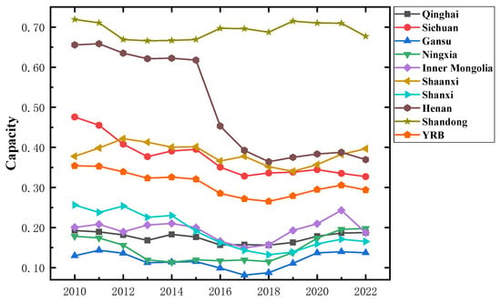
Figure 5.
Resistance trends of the water resources system in the YRB overall and at the provincial scale.
As can be seen from Figure 6, the development trend of restoration capacity in the YRB and provinces from 2010 to 2022 was relatively stable, the fluctuation amplitude of Henan was relatively large, and the restoration capacity of Ningxia was always in the first position and much higher than that of other provinces. Ningxia had the highest per-capita water supply, the development and utilization rate of water resources and surface water resources was much higher than that of other provinces, and the level of water resources development and utilization was relatively high. Furthermore, the structure of the industry was becoming more and more reasonable, the proportion of the tertiary industry was increasing, and the proportion of the secondary industry was decreasing. Additionally, the rate of urban sewage treatment was constantly improving, the total amount of industrial wastewater discharged was relatively low, and the rate of eco-friendly water consumption was showing an increasing trend year by year. Henan Province had two peaks in 2013 and 2019. The per-capita water supply in 2013 reached its highest value in the 13-year time period; the development and utilization rate of water resources was higher in 2013 and 2019; the development and utilization rate of surface water resources reached the highest in 2019; and the development and utilization rate of groundwater resources was higher in 2013 and reached the highest in 2019, but there was not a big difference between the values of these two years. The tertiary industry showed an increasing trend in its share, the urban sewage treatment rate was improving, and the ecological water use rate showed a linear growth trend, which was higher than that of other provinces.
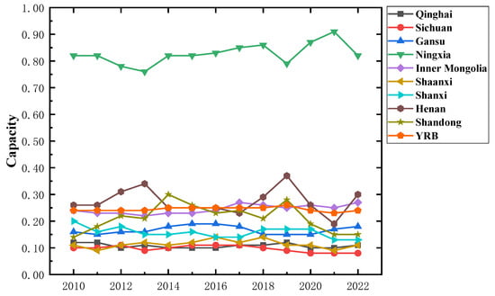
Figure 6.
Restoration trends of water resources system in the YRB overall and at the provincial scale.
As can be seen from Figure 7, the development trend of adaptive capacity in the YRB and provinces from 2010 to 2022 was relatively stable, with Ningxia always in the first position, and Sichuan showed a decreasing trend after reaching the highest value in 2016, and then showed an increasing trend in 2021. Most of the remaining provinces showed a turning point in 2015. Ningxia’s ecological environment investment was high, of which the proportion of industrial pollution control investment in GDP and the proportion of wastewater control investment in GDP were both high and increasing. Further, the urbanization rate showed a fluctuating trend of growth, while the water consumption of 10,000 yuan of GDP and 10,000 yuan of industrial added-value water consumption showed a trend of reduction year by year.
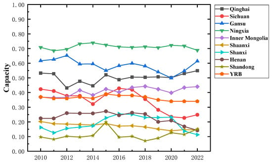
Figure 7.
Adaptability trends of the water resources system in the YRB overall and at the provincial scale.
3.1.3. Development Trends of Three Dimensions at the Provincial Scale
The trend of capacity changes in the YRB and nine provinces from 2010 to 2022 is shown in Figure 8.
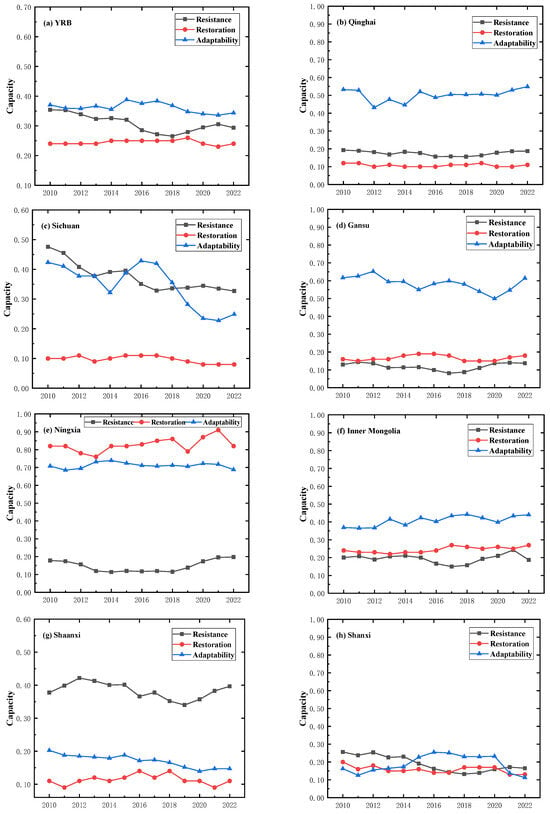
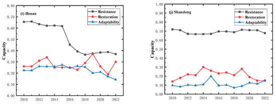
Figure 8.
Trends in resistance, restoration, and adaptability of water resources systems in the YRB and at the provincial scale.
As can be seen from Figure 8, the overall development trend of the YRB was relatively stable, and the adaptability capacity was higher than the resistance and restoration. In terms of spatial trends within the provinces, regarding resistance capacity of the water resources system, the order from high to low is Shandong > Sichuan > Henan > Shaanxi > Qinghai > Ningxia > Inner Mongolia > Shanxi > Gansu. This showed a decreasing trend from west to east. Evaluating restoration capacity of the water resources system, the ranking from high to low is Ningxia > Inner Mongolia > Henan > Shandong > Shanxi > Gansu > Shaanxi > Sichuan > Qinghai. For the adaptability capacity of the water resources system, the order from high to low is Ningxia > Gansu > Qinghai > Inner Mongolia > Sichuan > Henan > Shaanxi > Shanxi > Shandong.
From the perspective of time trend, for the resistance of water resources system, except for Henan, which showed a significant decline in 2015, all other provinces showed fluctuating and increasing development trends. Gansu showed the worst resistance and Shandong the best resistance. Regarding the restoration of the water resources system, all nine provinces and regions showed fluctuating and increasing trends, and Qinghai showed the worst restoration and Ningxia the best restoration. Furthermore, the adaptability of the water resources system in other provinces from the study area showed an increasing trend of fluctuation, where Shandong had the worst adaptability and Ningxia had the best adaptability. Two exceptions were Shanxi and Henan, which showed a decreasing trend of fluctuation.
3.1.4. Spatial Distribution of WRSR
Using the natural breakpoint method in ArcGIS to draw the resilience level spatial map of the water resources system in the YRB (see Figure 9), the level of the WRSR overall was optimal in the upper reaches and lower reaches of the YRB, and weakest in the middle reaches. The resilience level of individual provinces fluctuated considerably, but Ningxia’s resilience area was always at a high value.
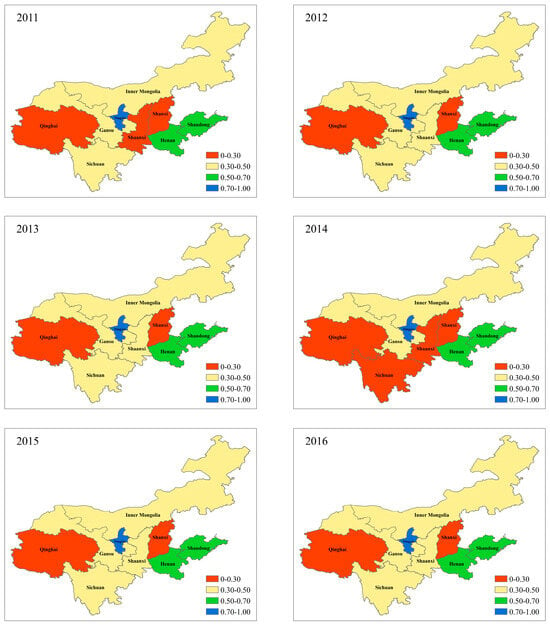
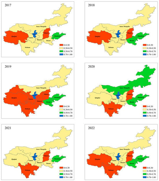
Figure 9.
Distribution of WRSR levels in nine provinces and regions in the YRB from 2011 to 2022.
Most of the upper reaches (Qinghai, Sichuan, Gansu, Ningxia, Inner Mongolia) fluctuated between low value and high value resilience zones, while Ningxia remained in the high value resilience zone. Since Ningxia belongs to the YRB, in recent years, ecological restoration and management projects have been implemented to create ecological parks which continuously improved the ecological environment. For example, a high-level environment for technological innovation and a modern industrial base were constructed, and the proportion of high-tech enterprises also increased year by year. Inner Mongolia had always been in the low resilience zone, but in 2020, it was elevated to the high resilience zone. Inner Mongolia adhered to the path of ecological priority and green development, and the water consumption per 10,000 yuan of GDP and per 10,000 yuan of industrial added value both showed a decreasing trend. Inner Mongolia vigorously developed a modern energy economy, building the largest coal power and coal chemical industry base in the country and continuing to improve optimization and adjustment with the industrial structure. Furthermore, it drove the development of an entire new energy industry chain. Qinghai was always in the very low resilience zone, but improved to the low resilience zone in 2020 and 2021. Although Qinghai had abundant water resources, however, with the increase of energy industry investment and huge water consumption, the matching relationship between water and other resources had changed [57].
The development trend of the middle reaches (Shaanxi, Shanxi) was not optimistic, and Shanxi had always been in the very low resilience value zone. On the other hand, Shaanxi fluctuates between very low value and high value resilience zones. The per-capita water supply in Shanxi was low, the water resources endowment was weak, and the water production and supply modules were both low, seriously restricting the development of the social economy. The proportion of industrial pollution control investment to GDP and the proportion of wastewater pollution control investment to GDP were both low. The per-capita GDP was lower than the national level, the industrial structure was relatively unbalanced, and the coal industry still occupied an important position in industry. Shanxi had been actively exploring the transformation of a resource-based economy since 2017, and its economic growth rate had increased.
In the past decade, the total economic output of Shaanxi had continued to increase, and the per-capita GDP had reached the level of a middle to upper-income country. Industrial transformation and upgrading were accelerating, with strong growth momentum in new driving forces. The proportion of the tertiary industry was steadily increasing, and the industrial structure was continuously optimizing. The “14th Five Year Plan” for ecological and environmental protection in Shaanxi Province was officially issued in 2021, setting key goals in areas such as environmental governance, climate change response, environmental risk prevention and control, and ecological and environmental protection.
The lower reaches (Henan, Shandong) were always located in the high value resilience zone. Shandong had always been in the high value resilience zone, while Henan was in the low resilience zone in 2017 and 2021, and in the remaining years was in the high value resilience zone.
Shandong had good water resources endowment and indicators such as total precipitation, per-capita water resources, water production modulus, and water supply modulus. These all fluctuated and increased. The development and utilization of water resources were relatively reasonable, with a decrease in the utilization rate of surface water resources and groundwater resources. The economic growth rate was fast, and the per-capita GDP showed a linear growth trend. The structure of the tertiary industry was increasingly optimized. Great importance was attached to treatment of the ecological environment, including the emissions of ammonia nitrogen and COD in wastewater, as well as the total amount of industrial wastewater. These were showing a decreasing trend. The urban sewage treatment rate had been increasing year by year, and the ecological water use rate had also been increasing year by year. The matching coefficients between water resources and land, population, and GDP all showed a fluctuating upward trend, but the matching coefficient between water resources and GDP was relatively low. Further optimization of the industrial structure is needed to improve the efficiency of industrial water use.
In 2017, the economic situation in Henan showed a stable and positive development trend, but structural contradictions remained prominent. Compared with the national average, the problem of a high proportion of primary and secondary industries and low proportion of tertiary industries was more serious. Traditional industries and high energy-consuming industries still accounted for a large proportion. Due to the impact of catastrophic floods and the COVID-19 pandemic, Henan’s economic growth in 2021 was lower than that of the entire country. However, all regions and departments throughout the province focused on the following aspects: deepening reform, expanding and opening up, cultivating new drivers of economic development, and accelerating the transformation of industrial structure. Furthermore, Henan continued developing new industries with new formats and products, vigorously promoting the development of clean energy such as wind, biomass, and solar energy, and maintaining a stable recovery and sound development of the economy.
3.2. Identification of Driving Factors of WRSR in the YRB
In order to further analyze the regulatory factors of WRSR, the main impact indicators of WRSR from 2010 to 2022 were calculated based on the geographical detectors model, and the top 10 indicator factors with the greatest impact in each year were identified (see Table 3).

Table 3.
The top ten factors in factor detection ranking in the YRB from 2010 to 2022.
From Table 3, it can be seen that the top five influencing factors of the WRSR in the YRB within the research interval are development and utilization ratio of surface water resources (C14), development and utilization rate of water resources (C13), water consumption per 10,000 yuan of GDP (C26), per capita water supply (C12), and proportion of investment in wastewater treatment to GDP (C30). The top ten influencing factors mainly come from the restoration subsystem.
From the trend of changes in the influencing factors of each subsystem, development and utilization ratio of water resources (C13) and development and utilization ratio of surface water resources (C14) in the restoration subsystem consistently rank in the top two, while the water consumption per 10,000 yuan of GDP (C26) in the adaptability subsystem ranks in the top ten every year. The natural population growth rate (C6) in the resistant subsystem, ammonia nitrogen emissions in wastewater (C9), and total precipitation (C2) show an upward trend, indicating that external and internal pressures have a strong impact on the resilience level of complex systems.
4. Discussion
Scholars have paid attention to sustainable development issues in the YRB from a resilience perspective, but existing achievements mostly focus on regional urban resilience, economic resilience, and agricultural water resources system resilience [58,59,60]. There is relatively little research on regional WRSR. Therefore, this study took a comprehensive perspective and considered factors such as water resources, the social economy, and ecological environment. Next, it constructed an evaluation index system for the WRSR in the YRB from three dimensions: resistance, restoration, and adaptability. This study further analyzed the spatio-temporal evolution characteristics of the WRSR in the YRB, explored the ability level of subsystems, and identified the driving factors that affect the level of the WRSR. Finally, this study provided reference and inspiration for the construction of a high development path for the water resources system in the YRB.
This article used the entropy weight TOPSIS method to evaluate the level of the WRSR in the YRB from 2010 to 2022, and the research results are consistent with those of other scholars [61]. For example, Wu [62] proposed the concepts of the human–land system and resilience, then constructed an evaluation index system to evaluate the resilience of the human–land system in the YRB from three dimensions, including economic, social, and ecological. GIS spatial analysis and a coupling coordination model were used to explore the spatio-temporal evolution pattern of the human–land system resilience in the YRB and the coupling coordination status between subsystems. The study found that from 2000 to 2020, the human–land system resilience in the YRB showed an overall strengthening trend, with a distribution characteristic that was high in the southeast and low in the northwestern space. The high resilience areas of the regional human–land system were still concentrated in the downstream areas of the east, and the differences between the east and the west were still significant. More attention should be paid to the economic, social, and ecological issues in the upstream areas of the west.
This article mainly starts from the concept of WRSR, considering the relationship between human and water systems, as well as the social economy, and ecological environmental factors. Furthermore, the addition of water resources is mainly due to the fact that water scarcity is the biggest contradiction faced in the development of the YRB, and water resources play an important role in the development of the YRB. The results identified that the overall WRSR in the YRB and various provinces showed a fluctuating increasing trend, while Ningxia and Shanxi showed a decreasing trend despite fluctuations. The WRSR of the downstream is always higher than that of the middle and upper reaches. From 2010 to 2022, the overall resistance, restoration, and adaptability of the YRB and various provinces showed a stable increasing trend. Shandong’s resistance ability is much higher than that of other provinces, and Ningxia’s restoration ability is much higher than that of other provinces. The factors that affect the WRSR in the YRB within the research interval mainly came from the restoration subsystem, and the impact of resistance subsystem-related indicators on the WRSR showed an upward trend. External and endogenous pressures had a stronger impact on the level of the WRSR.
The lower reaches region is the core area of economic development in the YRB, with a relatively complete industrial structure. At the same time, the high level of economic development has driven improved development of regional science, education, culture, and health undertakings, thereby promoting social development and progress, which is conducive to the improvement of the resilience level of the water resources system. The differences in restoration and adaptability among provinces are relatively small. The implementation of major national ecological projects and policies has improved the ecological environment quality in the central and western parts of the YRB, which is conducive to reducing resilience and adaptability of the water resources system in the eastern and western regions. Specifically, the average value of Shanxi’s WRSR is the lowest, with a relatively poor level of resilience. Shanxi has poor water resource endowment, with lower per-capita water resources and water supply compared to other regions. The water production and supply modules are both low, and water scarcity has become one of the main problems restricting local economic development. In addition, the secondary industry accounts for a large proportion, and Shanxi’s industries are mainly dominated by coal and other energy-consuming industries, which consume a large amount of water resources and cause serious environmental pollution. Shanxi needs to establish a strict water resource management system, formulate water-saving plans, accelerate the innovation of water-saving technology, strictly control the water consumption of the primary industry, and promote the optimization and upgrading of industrial structure to effectively improve the efficiency of industrial water use, thereby improving the matching degree between industrial water use structure and industrial structure.
Overall, the nine provinces and regions in the Yellow River Basin should adopt the strategic approach of “jointly promoting large-scale protection and coordinated promotion of large-scale governance”, and promote ecological protection and high-quality development in the YRB through green development.
Firstly, the government should establish an ecological protection mechanism and improve relevant laws and regulations on ecological protection [63].
Secondly, the government should improve the circular and efficient utilization of resources in traditional industries such as coal, accelerate the formation of new energy conservation industries, and cultivate new industrial entities. Additionally, it should vigorously develop water-saving industries and technologies to achieve sustainable economic development.
Thirdly, the government should focus on collaborative development. Each province formulates development goals for ecological, economic, and social coordination, implements the main responsibilities of each department, and promotes a balance between economic and social development and water resource development and utilization within the basin [64].
Finally, the government should promote industrial development. Each province should make medium and long-term plans, establish an ecological, systematic, multi-dimensional innovation system, and further enhance industrial innovation through technological innovation [65]. With the optimization and upgrading of the industrial structure, technological upgrading and energy structure improvement can be achieved, and the utilization efficiency of energy and the ecological efficiency of the industry can be improved through new technologies [66,67,68].
5. Conclusions
This research evaluated the WRSR in the YRB from 2010 to 2022 and identified the driving factors affecting WRSR. The research has come to the following main conclusions: (1) The overall WRSR in the YRB and various provinces showed a fluctuating increasing trend, while Ningxia and Shanxi showed a decreasing trend despite fluctuations. (2) The overall development trend of resistance capacity in the YRB and nine provinces from 2010 to 2022 was relatively stable. Shandong’s resistance capacity far exceeded that of other provinces, while Henan’s resistance capacity sharply declined in 2015, and then the development trend gradually stabilized. (3) The development trend of restoration capacity in the YRB and various provinces from 2010 to 2022 was relatively stable, while the fluctuation range in Henan was relatively large. Ningxia’s restoration capacity always ranked first and was much higher compared to other provinces. (4) The development trend of adaptability in the YRB and various provinces remained relatively stable from 2010 to 2022, with Ningxia consistently ranked first. After reaching its highest value in 2016, Sichuan showed a downward trend, and then showed an upward trend in 2021.
This research considered the impact of water resources, social economy, and ecological environment on resilience levels of a water resources system. An evaluation index system for a water resources system is constructed from the three stages characteristic of resilience. The entropy weight TOPSIS method was used to calculate the overall value of WRSR in the YRB and nine provinces from 2010 to 2022. The study was conducted from three dimensions, and the three dimensions of each region were analyzed separately. Finally, factor detection in geographic detectors was used to identify the main factors affecting the WRSR, in order to take relevant measures to achieve ecological protection and high-quality development in the watershed.
Author Contributions
Conceptualization, J.L. and L.Y.; Methodology, J.L. and L.Y.; Investigation, W.H., L.Y. and D.M.D.; Writing—original draft, J.L., E.J., B.Q., L.Y. and D.M.D.; Writing—review & editing, J.L., L.Y. and T.S.R. All authors have read and agreed to the published version of the manuscript.
Funding
This research was funded by the National Natural Science Foundation of China [No. 72104127 and 71874101], the Ministry of Education (MOE) of China, Project of Humanities and Social Sciences [No. 20YJCGJW009], the Major Program of National Social Science Foundation of China [No. 19ZDA08].
Data Availability Statement
The data presented in this study are available on request from the corresponding author.
Conflicts of Interest
The authors declare no conflict of interest.
References
- Darko, G.; Obiri-Yeboah, S.; Takyi, S.A.; Amponsah, O.; Borquaye, L.S.; Amponsah, L.O.; Fosu-Mensah, B.Y. Urbanizing with or without nature: Pollution effects of human activities on water quality of major rivers that drain the Kumasi Metropolis of Ghana. Environ. Monit. Assess. 2022, 194, 38. [Google Scholar] [CrossRef] [PubMed]
- Guo, Y.; Li, P.; He, X.; Wang, L. Groundwater Quality in and Around a Landfill in Northwest China: Characteristic Pollutant Identification, Health Risk Assessment, and Controlling Factor Analysis. Expo. Health 2022, 14, 885–901. [Google Scholar] [CrossRef]
- Khan, M.H.; Nafees, M.; Muhammad, N.; Ullah, U.; Bilal, M. Assessment of Drinking Water Sources for Water Quality, Human Health Risks, and Pollution Sources: A Case Study of the District Bajaur, Pakistan. Arch. Environ. Contam. Toxicol. 2021, 80, 41–54. [Google Scholar] [CrossRef] [PubMed]
- Lee, M.H.; Im, E.S.; Bae, D.H. A comparative assessment of climate change impacts on drought over Korea based on multiple climate projections and multiple drought indices. Clim. Dyn. 2019, 53, 389–404. [Google Scholar] [CrossRef]
- Trenberth, M.K.E. Climate Change and Drought: A Perspective on Drought Indices. Curr. Clim. Chang. Rep. 2018, 4, 145–163. [Google Scholar]
- Wang, G.; Xiao, C.; Qi, Z.; Meng, F.; Liang, X. Development tendency analysis for the water resource carrying capacity based on system dynamics model and the improved fuzzy comprehensive evaluation method in the Changchun city, China. Ecol. Indic. 2021, 122, 14. [Google Scholar] [CrossRef]
- Jodar-Abellan, A.; Fernandez-Aracil, P.; Melgarejo-Moreno, J. Assessing Water Shortage through a Balance Model among Transfers, Groundwater, Desalination, Wastewater Reuse, and Water Demands (SE Spain). Water 2019, 11, 1009. [Google Scholar] [CrossRef]
- Colella, M.; Ripa, M.; Cocozza, A.; Panfilo, C.; Ulgiati, S. Challenges and opportunities for more efficient water use and circular wastewater management. The case of Campania Region, Italy. J. Environ. Manag. 2021, 297, 113171. [Google Scholar] [CrossRef]
- Pan, Z.; Jin, J.; Wang, J.; Wu, C. Mechanism and quantitative analysis of water resources system adaptability under changing environment. J. Water Resour. Water Eng. 2020, 31, 9–16. [Google Scholar]
- Yuan, L.; Qi, Y.; He, W.; Wu, X.; Kong, Y.; Ramsey, T.S.; Degefu, D.M. A differential game of water pollution management in the trans-jurisdictional river basin. J. Clean. Prod. 2024, 438, 140823. [Google Scholar] [CrossRef]
- Wang, H.; Yang, Y.; Yang, R.; Deng, C.; Gong, S. Uncertainty Thought of Water Resources System Security: From Risk to Resilience. J. North China Univ. Water Resour. Electr. Power (Nat. Sci. Ed.) 2022, 43, 1–8. [Google Scholar]
- Saikia, P.; Beane, G.; Garriga, R.G.; Avello, P.; Ellis, L.; Fisher, S.; Leten, J.; Ruiz-Apilánez, I.; Shouler, M.; Ward, R.; et al. City Water Resilience Framework: A governance based planning tool to enhance urban water resilience. Sustain. Cities Soc. 2022, 77, 9. [Google Scholar] [CrossRef]
- Anamaghi, S.; Behboudian, M.; Mahjouri, N.; Kerachian, R. A resilience-based framework for evaluating the carrying capacity of water and environmental resources under the climate change. Sci. Total Environ. 2023, 902, 165986. [Google Scholar] [CrossRef]
- Behboudian, M.; Kerachian, R. Evaluating the resilience of water resources management scenarios using the evidential reasoning approach: The Zarrinehrud river basin experience. J. Environ. Manag. 2021, 284, 112025. [Google Scholar] [CrossRef] [PubMed]
- Shen, Q.; Niu, J.; Liu, Q.; Liao, D.; Du, T. A resilience-based approach for water resources management over a typical agricultural region in Northwest China under water-energy-food nexus. Ecol. Indic. 2022, 144, 109562. [Google Scholar] [CrossRef]
- Capdevila, P.; Stott, I.; Menor, I.O.; Stouffer, D.B.; Raimundo, R.L.G.; White, H.; Barbour, M.; Salguero-Gómez, R. Reconciling resilience across ecological systems, species and subdisciplines. J. Ecol. 2021, 109, 3102–3113. [Google Scholar] [CrossRef]
- Guan, H.; Yang, Q.; Hao, F.; Feng, Z. Economic resilience characteristics of Shenyang city based on a perspective of industry-enterprise-space. Acta Geogr. Sin. 2021, 76, 415–427. [Google Scholar]
- Klise, K.A.; Murray, R.; Walker, L.T.N. Systems Measures of Water Distribution System Resilience; Sandia National Lab. (SNL-NM): Albuquerque, NM, USA, 2015.
- Martin, R. Regional economic resilience, hysteresis and recessionary shocks. J. Econ. Geogr. 2012, 12, 1–32. [Google Scholar] [CrossRef]
- Simonovic, S.P.; Arunkumar, R. Quantification of resilience to water scarcity, a dynamic measure in time and space. Proc. Int. Assoc. Hydrol. Sci. 2016, 373, 13–17. [Google Scholar] [CrossRef]
- Zhao, Z.; Wang, H.; Zhang, L.; Liu, X.; Zhao, Y. Construction and application of resilience evaluation model of water resources-water environment-social economy complex system in the Yangtze River Economic Belt. Adv. Water Sci. 2022, 33, 705–717. [Google Scholar]
- Wang, S.; Yang, J.; Wang, A.; Yan, Y.; Liu, T. Coupled coordination of water resources-economy-ecosystem complex in the Henan section of the Yellow River basin. Water Supply 2022, 22, 8835–8848. [Google Scholar] [CrossRef]
- Yang, Y.; Wang, H.; Gong, S.; Deng, C. Variable Pythagorean fuzzy VIKOR evaluation regulation model of water resources system resilience and its application. J. Hydraul. Eng. 2021, 52, 633–646. [Google Scholar]
- Wang, X.; Shi, J.; Ci, F. Spatial and temporal evolution characteristics of the resilience of urban agglomerations in the Yellow River Basin. Stat. Decis. 2022, 38, 70–74. [Google Scholar]
- Aghakouchak, A.; Mazdiyasni, O.; Mehran, A. A hybrid framework for assessing socioeconomic drought: Linking climate variability, local resilience, and demand. J. Geophys. Res. Atmos. 2015, 120, 7520–7533. [Google Scholar]
- Guo, Y.; Huang, S.; Huang, Q.; Wang, H.; Fang, W.; Yang, Y.; Wang, L. Assessing socioeconomic drought based on an improved Multivariate Standardized Reliability and Resilience Index. J. Hydrol. 2019, 568, 904–918. [Google Scholar] [CrossRef]
- Huang, S.; Huang, Q.; Leng, G.; Liu, S. A nonparametric multivariate standardized drought index for characterizing socioeconomic drought: A case study in the Heihe River Basin. J. Hydrol. 2016, 542, 875–883. [Google Scholar] [CrossRef]
- Lu, C.; Ji, W.; Hou, M.; Ma, T.; Mao, J. Evaluation of efficiency and resilience of agricultural water resources system in the Yellow River Basin, China. Agric. Water Manag. 2022, 266, 13. [Google Scholar] [CrossRef]
- Cheng, X.; Long, R.; Chen, H.; Li, Q. Coupling coordination degree and spatial dynamic evolution of a regional green competitiveness system—A case study from China. Ecol. Indic. 2019, 104, 489–500. [Google Scholar] [CrossRef]
- Han, H.; Guo, L.; Zhang, J.; Zhang, K.; Cui, N. Spatiotemporal analysis of the coordination of economic development, resource utilization, and environmental quality in the Beijing-Tianjin-Hebei urban agglomeration. Ecol. Indic. 2021, 127, 107724. [Google Scholar] [CrossRef]
- Luo, P.; Xu, C.; Kang, S.; Huo, A.; Lyu, J.; Zhou, M.; Nover, D. Heavy metals in water and surface sediments of the Fenghe River Basin, China: Assessment and source analysis. Water Sci. Technol. 2021, 84, 3072–3090. [Google Scholar] [CrossRef]
- Luo, D.; Liang, L.; Wang, Z.S.; Chen, L.; Zhang, F. Exploration of coupling effects in the Economy–Society–Environment system in urban areas: Case study of the Yangtze River Delta Urban Agglomeration—ScienceDirect. Ecol. Indic. 2021, 128, 107858. [Google Scholar]
- Zhou, S.; Wang, X.; Tong, J. Resilience analysis of water resources system of the Yangtze River Basin based on pressure-state-response model. J. Econ. Water Resour. 2023, 41, 23–28+57+123–124. [Google Scholar]
- An, M.; Song, M.; He, W.; Huang, J.; Fang, X. Evaluate cities’ urban water resources system resilience along a river and identify its critical driving factors. Environ. Sci. Pollut. Res. 2023, 30, 16355–16371. [Google Scholar] [CrossRef] [PubMed]
- Sun, C.; Meng, C. Evaluation of the Development Coordination Relationship between Resilience and Efficiency of Regional Water Resources System in China. Sci. Geogr. Sin. 2020, 40, 2094–2104. [Google Scholar]
- Zhao, Z.; Yang, Y.; Xu, D.; Liu, C.; Wang, H. Resilience Evaluation and Regulation Model of Water Resources System Based on Two-level Fuzzy Comprehensive Evaluation and Its Application. Water Resour. Power 2022, 40, 39–43. [Google Scholar]
- Stojkovic, M.; Marjanovic, D.; Rakic, D.; Ivetic, D.; Simic, V.; Milivojevic, N.; Trajkovic, S. Assessment of water resources system resilience under hazardous events using system dynamic approach and artificial neural networks. J. Hydroinformatics 2023, 25, 208–225. [Google Scholar] [CrossRef]
- Liu, D. Evaluating the dynamic resilience process of a regional water resource system through the nexus approach and resilience routing analysis. J. Hydrol. 2019, 578, 13. [Google Scholar] [CrossRef]
- Yang, Y.; Wang, H.; Zhao, Y.; Gong, S. A Three-Way Decision Approach for Water Resources System Resilience Evaluation and Its Application. Water Resour. 2022, 49, 1093–1104. [Google Scholar] [CrossRef]
- Herrera-Franco, G.; Carrión-Mero, P.; Aguilar-Aguilar, M.; Morante-Carballo, F.; Jaya-Montalvo, M.; Morillo-Balsera, M.C. Groundwater Resilience Assessment in a Communal Coastal Aquifer System. The Case of Manglaralto in Santa Elena, Ecuador. Sustainability 2020, 12, 8290. [Google Scholar] [CrossRef]
- Liu, D.; Xu, L.; Fu, Q.; Li, M.; Faiz, M.A. Identification of resilience characteristics of a regional agricultural water resources system based on index optimization and improved support vector machine. Water Sci. Technol. Water Supply 2019, 19, 1899–1910. [Google Scholar] [CrossRef]
- Wang, G.; Li, M. Spatial-temporal coupling between water resources and regional development in the Yellow River Basin. J. Arid Land Resour. Environ. 2023, 37, 8–15. [Google Scholar]
- Xing, X.; Xiu, C.; Liu, Y. Water security assessment of Yellow River Basin based on water footprint theory. Chin. J. Agric. Resour. Reg. Plan. 2022, 43, 250–258. [Google Scholar]
- Zuo, Q.; Li, J.; Yu, L. Mechanism and harmony regulation of human-water relationship in Yellow River basin. J. Hydroelectr. Eng. 2022, 41, 1–8. [Google Scholar]
- Hu, Y.; Wei, F.; Fu, B.; Wang, S.; Zhang, W.; Zhang, Y. Changes and influencing factors of ecosystem resilience in China. Environ. Res. Lett. 2023, 18, 9. [Google Scholar] [CrossRef]
- Peng, S.; Zheng, X.; Yan, D.; Shang, W. New situation and countermeasures of water resources supply and demand in the Yellow River Basin. China Water Resour. 2021, 18, 18–20+26. [Google Scholar]
- Xi, J. Speech at the Symposium on Ecological Protection and High-Quality Development of the Yellow River Basin. China Water Resour. 2019, 20, 1–3. [Google Scholar]
- Zuo, Q.; Zhang, Z.; Ma, J. Relationship between water resource utilization level and socio-economic development in the Yellow River Basin. China Popul. Resour. Environ. 2021, 31, 29–38. [Google Scholar]
- Lu, Q.; Yang, Y.; Li, B.; Li, Y.; Wang, D. Coupling Relationship and Influencing Factors of the Water-Energy-Cotton System in Tarim River Basin. Agronomy 2022, 12, 2333. [Google Scholar] [CrossRef]
- Meng, Y.; Wang, M.; Xu, W.; Guan, X.; Yan, D. Structure construction, evolution analysis and sustainability evaluation of Water-Ecological-Economic system. Sustain. Cities Soc. 2022, 83, 18. [Google Scholar] [CrossRef]
- Xiao, Y.; Wang, R.; Wang, F.; Huang, H.; Wang, J. Investigation on spatial and temporal variation of coupling coordination between socioeconomic and ecological environment: A case study of the Loess Plateau, China. Ecol. Indic. 2022, 136, 108667. [Google Scholar] [CrossRef]
- Zhang, K.; Dong, Z.; Guo, L.; Boyer, E.W.; Liu, J.; Chen, J.; Fan, B. Coupled coordination spatiotemporal analyses inform sustainable development and environmental protection for the Yellow River Basin of China. Ecol. Indic. 2023, 151, 14. [Google Scholar] [CrossRef]
- Zhu, C.; Fang, C.; Zhang, L. Analysis of the coupling coordinated development of the Population-Water-Ecology-Economy system in urban agglomerations and obstacle factors discrimination: A case study of the Tianshan North Slope Urban Agglomeration, China. Sustain. Cities Soc. 2023, 90, 13. [Google Scholar] [CrossRef]
- Lu, F.; Yin, W.; Liu, N. The spatio-temporal evolution of industrial resilience and its driving factors in the Yangtze River Delta Urban Agglomeration. World Reg. Stud. 2021, 30, 589–600. [Google Scholar]
- Kuang, L.H.; Ye, Y.C.; Zhao, X.M.; Guo, X. Evaluation and Obstacle Factor Diagnosis of Cultivated Land System Security in Yingtan City Based on the Improved TOPSIS Method. J. Nat. Resour. 2018, 33, 1627–1641. [Google Scholar]
- Chen, X.; Lou, J.; Wang, Y. Evolution and Dynamic Simulation of the Temporal-Spatial Pattern of Urban Resilience in Harbin-Changchun Urban Group. Sci. Geogr. Sin. 2020, 40, 2000–2009. [Google Scholar]
- Zhi, Y.; Wang, H.; Zhang, F.; Wang, Z.; Zhu, W. Assessment on the synergy of water-energy-food system in the Northwest China-Based on the complex system co-evolution theory. J. Arid Land Resour. Environ. 2022, 36, 76–85. [Google Scholar]
- Li, L.; Zhang, P.; Wang, C. What Affects the Economic Resilience of China’s Yellow River Basin Amid Economic Crisis-From the Perspective of Spatial Heterogeneity. Int. J. Environ. Res. Public Health 2022, 19, 20. [Google Scholar]
- Sun, J.; Chen, C.; Sun, Z. Urban Economic Resilience and Its Influencing Factors in the Yellow River Basin: From the Perspective of Different Types of City. Econ. Geogr. 2022, 42, 1–10. [Google Scholar]
- Zhang, X.; Tang, Q.; Zhang, Z. Spatial Differentiation Characteristics and Its Influencing Factors of Urban Resilience in the Yellow River Basin. Areal Res. Dev. 2022, 41, 48–54. [Google Scholar]
- Yuan, L.; Li, R.; Wu, X.; He, W.; Kong, Y.; Ramsey, T.S.; Degefu, D.M. Decoupling of economic growth and resources-environmental pressure in the Yangtze River Economic Belt, China. Ecol. Indic. 2023, 153, 110399. [Google Scholar] [CrossRef]
- Wu, K.; Kong, D.; An, C. Spatial-temporal evolution pattern and coordinated development of human-environment system resilience in the Yellow River Basin. J. Desert Res. 2023, 43, 246–257. [Google Scholar]
- Yuan, L.; Li, R.; He, W.; Wu, X.; Kong, Y.; Degefu, D.M.; Ramsey, T.S. Coordination of the Industrial-Ecological Economy in the Yangtze River Economic Belt, China. Front. Environ. Sci. 2022, 10, 882221. [Google Scholar] [CrossRef]
- Yuan, L.; Wu, X.; He, W.; Degefu, D.M.; Kong, Y.; Yang, Y.; Xu, S.; Ramsey, T.S. Utilizing the strategic concession behavior in a bargaining game for optimal allocation of water in a transboundary river basin during water bankruptcy. Environ. Impact Assess. Rev. 2023, 102, 107162. [Google Scholar] [CrossRef]
- Yuan, L.; Wu, X.; He, W.; Kong, Y.; Degefu, D.M.; Ramsey, T.S. Using the fuzzy evidential reasoning approach to assess and forecast the water conflict risk in transboundary Rivers: A case study of the Mekong river basin. J. Hydrol. 2023, 625, 130090. [Google Scholar] [CrossRef]
- He, W.; Zhang, K.; Kong, Y.; Yuan, L.; Peng, Q.; Mulugeta Degefu, D.; Ramsey Stephen, T.; Meng, X. Reduction pathways identification of agricultural water pollution in Hubei Province, China. Ecol. Indic. 2023, 153, 110464. [Google Scholar] [CrossRef]
- Kong, Y.; He, W.; Zhang, Z.; Shen, J.; Yuan, L.; Gao, X.; An, M.; Ramsey, T.S. Spatial-temporal variation and driving factors decomposition of agricultural grey water footprint in China. J. Environ. Manag. 2022, 318, 115601. [Google Scholar] [CrossRef]
- Kong, Y.; He, W.; Shen, J.; Yuan, L.; Gao, X.; Ramsey, T.S.; Peng, Q.; Degefu, D.M.; Sun, F. Adaptability analysis of water pollution and advanced industrial structure in Jiangsu Province, China. Ecol. Model. 2023, 481, 110365. [Google Scholar] [CrossRef]
Disclaimer/Publisher’s Note: The statements, opinions and data contained in all publications are solely those of the individual author(s) and contributor(s) and not of MDPI and/or the editor(s). MDPI and/or the editor(s) disclaim responsibility for any injury to people or property resulting from any ideas, methods, instructions or products referred to in the content. |
© 2024 by the authors. Licensee MDPI, Basel, Switzerland. This article is an open access article distributed under the terms and conditions of the Creative Commons Attribution (CC BY) license (https://creativecommons.org/licenses/by/4.0/).