Article

Spatial-Temporal Monitoring of Water Quality in Rural Property Enrolled in a Program for Payment for Environmental Water Services (PES-Water)—A Case Study in Brazil

by
Joice Machado Garcia
1,
Regina Márcia Longo
1,
Adélia Nobre Nunes
2 and
Raissa Caroline Gomes
1,*
1
Postgraduate Program in Urban Infrastructure System, Polytechnic School, Pontifical Catholic University of Campinas, Campinas 13087-571, Brazil
2
CEGOT—Centre for Studies in Geography and Spatial Planning, Department of Geography and Tourism, University of Coimbra, 3004-504 Coimbra, Portugal
*
Author to whom correspondence should be addressed.
Water 2024, 16(24), 3673; https://doi.org/10.3390/w16243673
Submission received: 4 November 2024 / Revised: 12 December 2024 / Accepted: 18 December 2024 / Published: 20 December 2024
(This article belongs to the Special Issue Water Quality Assessment of River Basins)

Abstract

:
Payments for ecosystem (or environmental) services (PES) encourage land users to manage their land in ways that deliver environmental benefits. This study aimed to assess the water quality in a rural property located in the Protection and Recovery of Watersheds of Campinas, which has been participating in the payment for ecosystem services program since 2018. More specifically, seven points of interest regarding the physicochemical indicators of the water were raised, which were subjected to descriptive statistical and variance analysis. The results revealed significant spatio-temporal variability in the monitored water quality indicators for dissolved oxygen, biochemical oxygen demand, pH, total phosphorus, and total nitrogen. More significant fluctuations were observed in the spatial location of the sampling points for turbidity, temperature, and electrical conductivity. However, the greatest variability depends on the time of year when the samples were collected.

1. Introduction

Ecosystem services are benefits provided, directly or indirectly, by biophysical elements and ecological functions to human beings, such as the provision of food and drinking water, climate regulation, and protection from natural disasters, and their existence is associated with the integrity of ecosystems, biodiversity, and anthropic actions [1].
However, the provision of ecosystem services has become scarce, mainly in urban centers, given that urban expansion causes changes in land use and coverage, especially benefiting the industrial and construction sector [2]. In addition to their reduction, the fact that these services are not priced by the economic market is another risk element. This is based on the assumption that environmental services are free, although they are used in the production of goods and services [3]. Given this scenario, the identification, management, and valuation of ecosystem services constitute some of the greatest challenges for urban planning in the 21st century.
Payments for environmental or ecosystem services (PES) can be seen as (1) a tool to provide economic incentives or compensation for land users that can promote ecosystem services [4]; (2) an instrument or mechanism capable of correcting market failure through the recognition of practices that guarantee, recover, or improve the provision of ecosystem services [5]. It could also become a means to promote biodiversity conservation and rural development, particularly in tropical and subtropical regions [6]; or (3) a policy tool to fund nature conservation efforts [7].
Payments for ecosystem services (PES) encourage land users to manage land in a way that provides environmental benefits. For example, the focus of many PES programs in Latin America is to increase or maintain the supply of good-quality water [8,9]. It is important to note that the importance of payment to land users is not restricted to a single service provided by the area in question, but may also be linked to a change in perception regarding the environmental services provided, leading to a change in habits and a feeling of recognition by society (4). However, this is a reality that is not well understood, with 42% of the PES analyzed in a study showing a crowding-out effect [7]. PES schemes are defended when environmental externalities are observed, such as a deforestation process that leads to loss of water quality. These situations can be corrected by creating ad hoc markets based on the Coase postulate, where the aim is to achieve optimum social welfare through negotiation, which in this case can be through payments to farmers in exchange for change to good management practices, which makes the cost of giving up forest exploitation practices worthwhile [8].
A PES proposal assumes that conservationist practices generate benefits for society and, more directly, for agents who benefit from cost reduction or improvement in the quality of inputs needed for their production processes. PES suggest the internalization of external benefits by sharing with the beneficiaries of environmental services the costs of carrying out the actions taken by the providers [10]. PES present an economic perspective of conservation, since the service provider finds in payment an incentive to change their behavior and guarantee the ecological balance of their productive activities [11]. However, for their correct functioning, PES programs need the main components to be defined: which services are a priority, which practices lead to the generation of this service, pre-disposition to payment, and possible payers [12].
Latin America has been a pioneer in the implementation of PES [8,13] by addressing four main ecosystem services: biodiversity conservation, watershed services, carbon sequestration, and scenic beauty [14]. The Atlantic Forest biome has stood out, being present in most of the 200 PES projects according to Forest Trends [15], and the projects are related to payments for watershed services (PWS), with a focus on water resource conservation [12]. Therefore, river ecosystems are important providers of essential services, such as the provision of water for human consumption [16]
In the case of Campinas (Brazil), the motivation for implementing the PES program was given in the face of the water crisis that affected its metropolitan region in the period from 2013 to 2015. The package to combat water scarcity provided the drafting of Municipal Law no. 15.046 of 2015, which instituted the PES program [17], and Municipal Decree no. 19.441 of 2017, which regulated the PES-Water subprogram [18].
The PES-Water proposal in the municipality was drawn up based on successful national and international experiences, such as the Conservador de Águas program in Extrema, Minas Gerais. From its implementation in 2017 until the end of 2020, the PES-Water Campinas had already benefited 127 properties, which included the planting of more than 109 thousand seedlings and the installation of 230 sanitary sewage systems [19]. The reviews of activity found for this experience are mostly qualitative and theoretical despite the volume of schemes currently in force [8]. For territorial management to be validated as a generator of water ecosystem services and to prove the effectiveness of PWS, hydrological monitoring is essential [20]. There is a gap in understanding how to evaluate and improve PES monitoring plans [21].
The analysis is consolidated as an important tool that aims to convince water users (supply and hydroelectric energy generation companies) to support the project, ensuring its financial sustainability and financing for impact assessments as a whole [22,23]. There is a relationship between the quality of water in the watershed and society’s environmental perception, where it is found that improving the quality of the resource maximizes the positive impact on social well-being [16]. A study that evaluated PES in Brazil presents data that the first PES program was initiated in 1997 in the state of Santa Catarina as part of a municipal policy to protect water resources [4]. Based on the above assumption that monitoring water quality on rural properties is part of PES programs and can contribute to the implementation of planned actions and help improve the quality and supply of water resources, the aim of this study was to assess the spatio-temporal variation in water quality on a rural property participating in a PES-Water program. To this end, seven sampling points were considered and evaluated over a period in order to gauge whether one year is sufficient to attribute changes in water quality as a result of the improvements implemented on the property under the PES program.

2. Materials and Methods

2.1. Study Area

The property used for the study is located in the hydrographic basin of the Atibaia River in the municipality of Campinas, São Paulo. It has been involved in the PES program since February 2018 and has an area of 102.9 ha, of which 14.4 ha constitute a permanent preservation area (PPA), 16.8 ha are vegetation remnants, and 58.3 ha are a grassland area.
There are four blocks into which the PES actions and goals were divided by the Personalized Property Program, defined as (i) the one that covers obligations pre-defined in legislation for forest restoration of protected areas and protection of native vegetation, called the forest code; (ii) the one that deals with rainwater drainage and domestic effluent management, called rural sanitation; (iii) the one that concerns the implementation of soil conservation practices, as well as the maintenance of existing practices, called soil conservation; and finally (iv) the one that concerns the authorization for the use of water resources, called grant. To evaluate the scenario, seven areas for bimonthly monitoring were proposed, as can be seen in Figure 1. The objective was to verify whether the actions and improvements implemented and/or seasonality could bring noticeable changes to the parameters considered. Therefore, the seven areas considered were defined ass (1) downstream property (external point to assess the quality of water leaving the property); (2) forest remnant (external course, PES planting); (3) sewer amount (before the treatment system and external course; higher water flow); (4) erosive process (conservation practices application; low water quantity); (5) consumption—nascent (spring displacement; livestock amount fencing); (6) livestock interference (cattle trampling; PES surrounding; downstream planting); and (7) property amount (prior to improvements; siltation; drainage work) [24].

2.2. Methodology

The water collection took place in the months of April 2019, July 2019, September 2019, November 2019, and January 2020, obtaining four samples at each point. The first stage of water quality analysis consisted of measuring the following parameters: dissolved oxygen—DO (oximeter); biochemical oxygen demand—BOD (oximeter and incubation); pH (potentiometer); temperature (oximeter); turbidity (turbidimeter); electrical conductivity (conductivity meter); total dissolved solids—TDS (gravimetry); total phosphorus (ascorbic acid method); total nitrogen (Kjeldahl digestion and distillation); and total coliforms (multiple tubes) [24]. All these were selected in view of their relevance in monitoring PES programs—water [25].
For the parameters DO, BOD, pH, turbidity, total phosphorus, and TDS, the contents of the elements were compared to the limits established by the Brazilian resolution of the Conselho Nacional de Meio Ambiente—CONAMA no. 357/05, which “provides for the classification of the bodies of water and environmental guidelines for its setting” [26]. This resolution presents threshold values for classifying water resources according to their quality and possible uses. Class 1 is considered the highest-quality water and can be used for more restricted uses (primary contact recreation, such as swimming, water skiing, and diving; irrigating vegetables that are eaten raw), while Class 4 can only be used for landscape harmony and navigation without human contact [26].
As the temperature, electrical conductivity, total nitrogen, and total coliforms parameters do not have limits defined by CONAMA Resolution no. 357/05 [26], they were compared under Ministry of Health Ordinance no. 2.914/2011 [27], updated in 2017 by Annex XX of Consolidation Ordinance no. 5/2017 [28], as well as legislation and/or academic works.
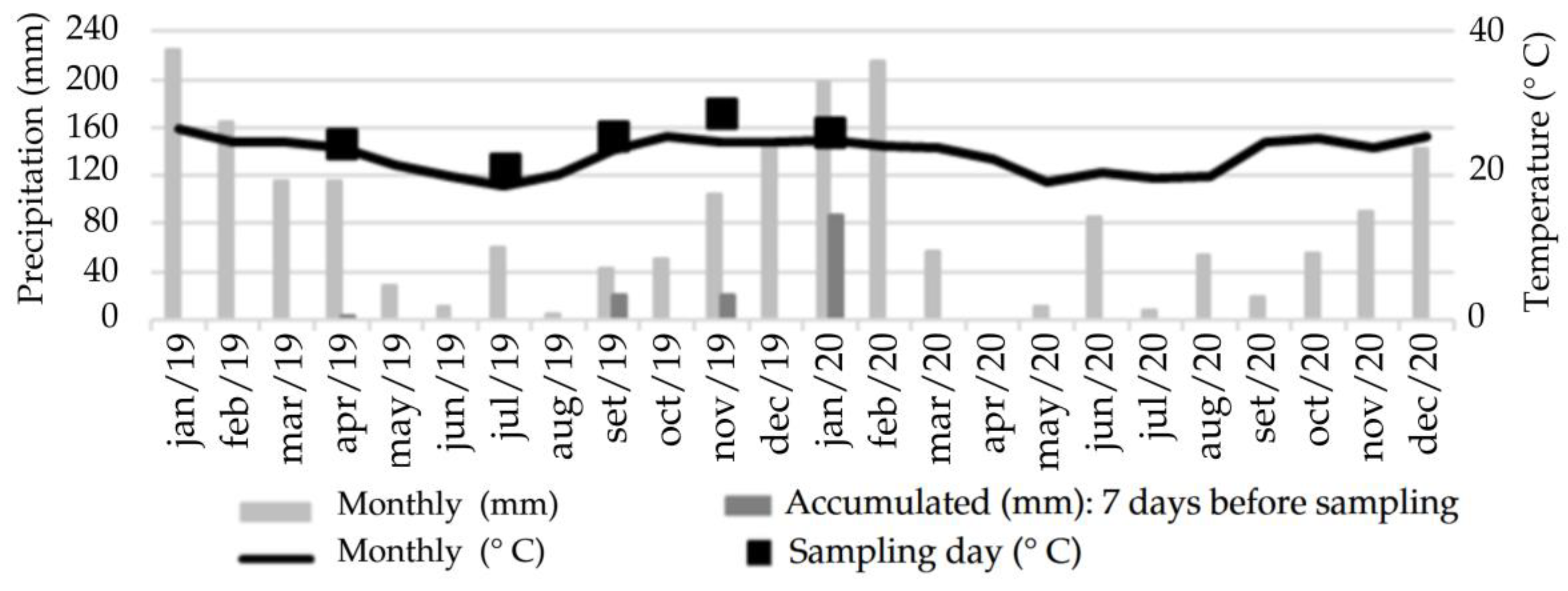
Figure 2 shows the average monthly rate of precipitation and temperature in the study period and before the collection days, according to the Centro Integrado de Informações Agrometeorológicas—CIIAGRO [29].
The water data were initially processed in Microsoft Excel, in which the position measures were defined: minimum, first quartile, median, third quartile, and maximum, used for the boxplot composition, grouping, and classification technique that consists of a box diagram for viewing trends, dispersion, form of distribution or symmetry, and deviations within the analyzed data [30].
Then, to check the effects of spatial and seasonal variation on the water quality parameters, and using Statistica 10.0 software, a two-way ANOVA was applied at a 5% level of significance. The experimental design adopted was a split-plot design or subdivided plots, with the treatments arranged in a 7 × 5 factorial scheme, i.e., seven collection points and five months of sampling, with four repetitions per point. The parameters that showed a statistically significant difference (p < 0.05) were subjected to the Tukey test to compare means between groups [31].

3. Results and Discussion

3.1. Spatial-Temporal Variability on Water Oxygen, Temperature, and pH

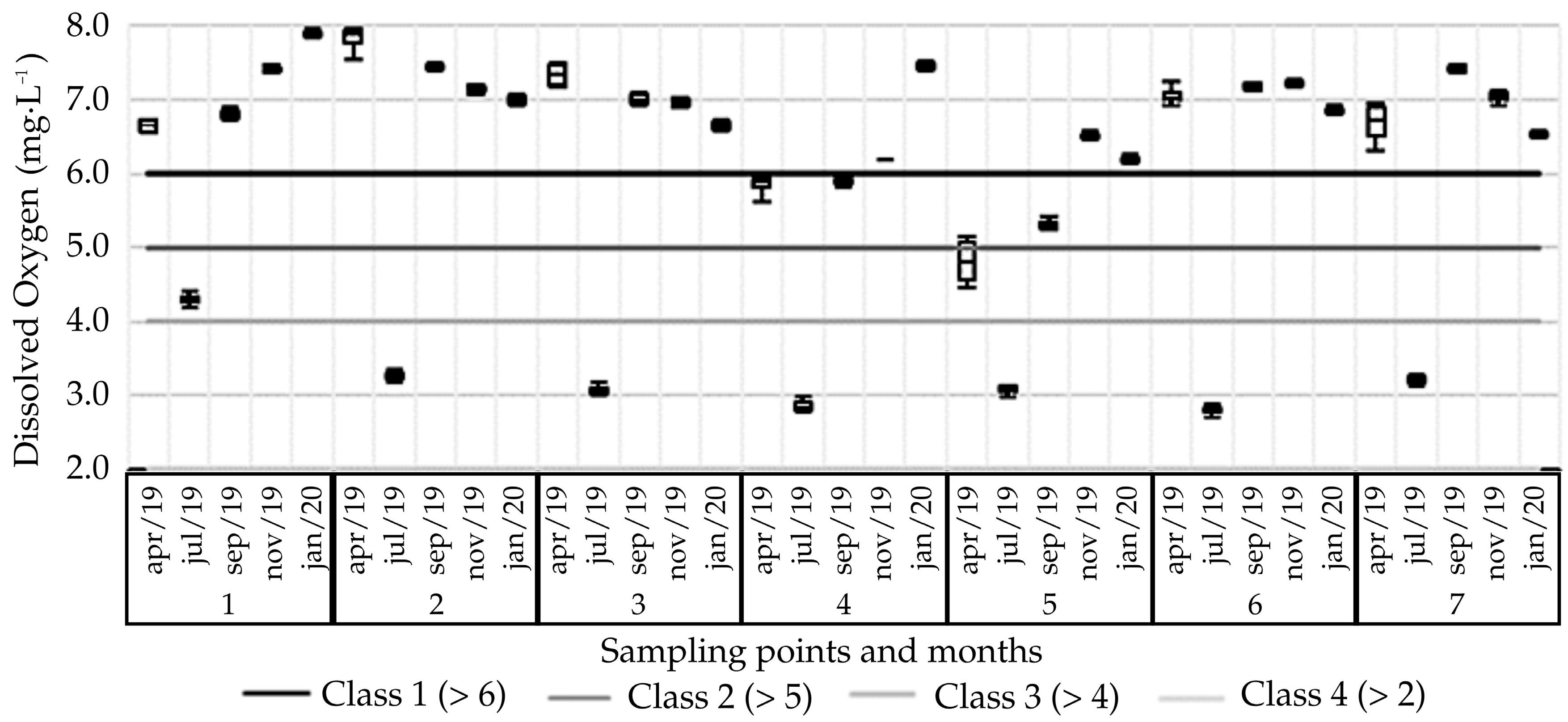
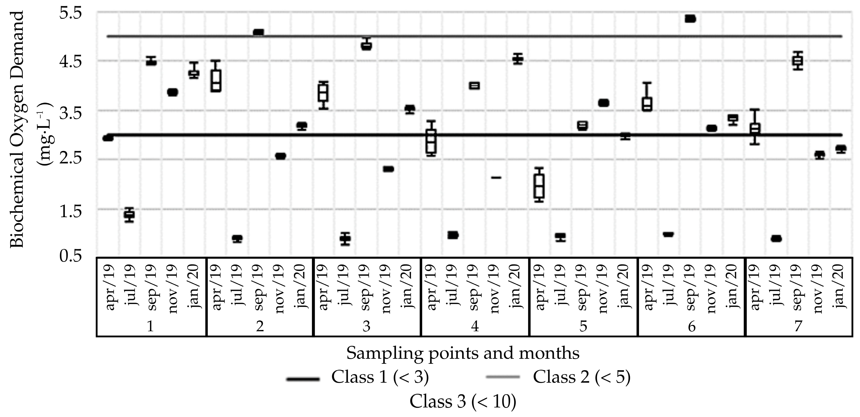
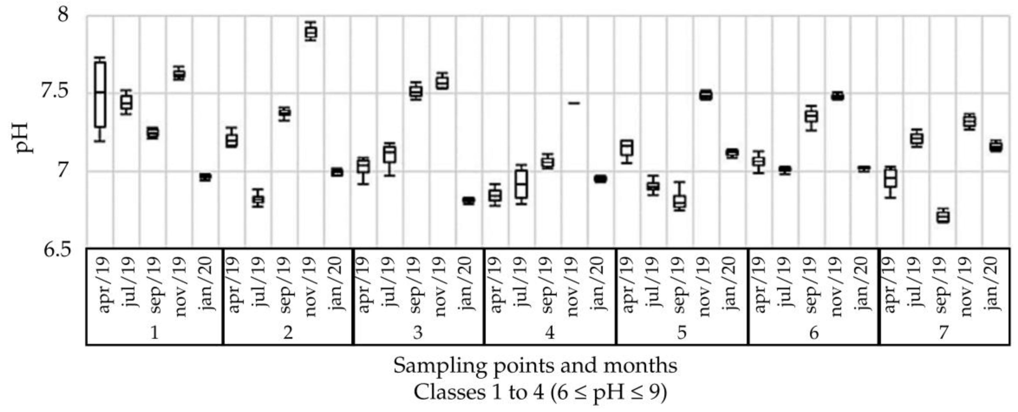
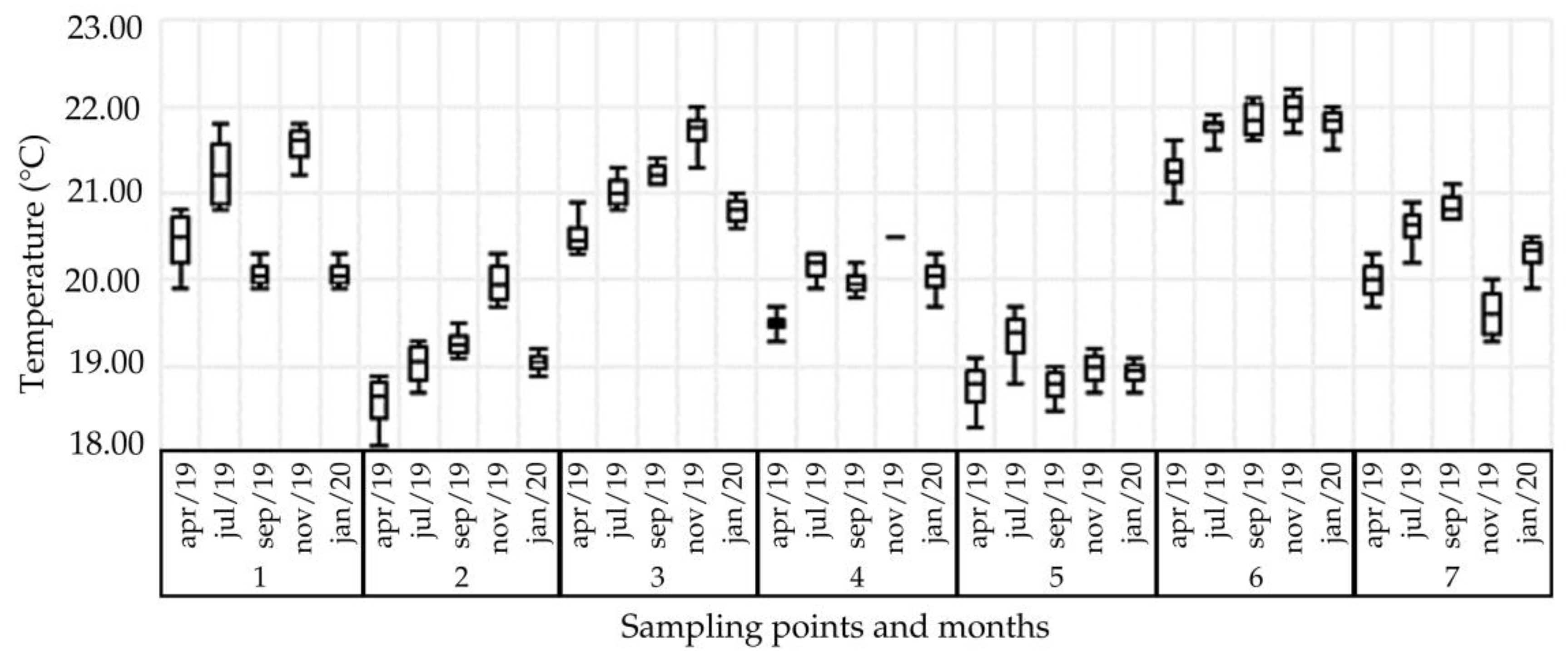
Table 1 presents the descriptive statistics and Tukey test for the parameters of dissolved oxygen, biochemical oxygen demand, pH, and temperature. To assist in the discussion, Figure 3, Figure 4, Figure 5 and Figure 6 show the boxplot distribution of the referred parameters, respectively.
For the DO parameter, there is a predominance of classification by Class 1 according to CONAMA Resolution 357/05 [26]: 68.6% of the samples have a DO content greater than 6 mg·L−1. The levels classified as Class 4 (DO content > 2 mg·L−1), which total 17.1% of the samples and refer to the July 2019 sampling, are explained by a technical failure in the measuring equipment, which postponed the measurement of the contents in one week and caused the lowering of the DO content.
There was no statistically significant difference between points 3, 6, and 7, whose averages are intermediate and around 6.20 mg·L−1. Point 5 showed, on average, that the DO content (5.18 mg·L−1) was lower than the other sample points. This finding was indicated by the Tukey test. This can probably be attributed to the thickness of the water layer from the point in question, since, visually, the water did not show any indications of contamination; at the same time, the BOD content obtained for it was lower than the other monitoring points, indicating a possible absence of organic contamination.
Point 1, which does not differ statistically from point 2, presented the highest DO content, considering the process of horizontal displacement of the water body and slope of the terrain, which allow greater swirling of the water and incorporation of oxygen in it. Of the points considered, this is the one that presented, in all samples, the largest volume of water.
From Figure 3, it is not possible to observe a pattern of increase or decrease in the DO content in the context of precipitation events. Even so, the highest DO average was observed in January 2020, the month in which the highest accumulated precipitation was observed prior to collection, and the lowest DO value was in July 2019, when precipitation prior to collection was zero.
The analysis of the DO content in terms of spatial variability indicated greater dispersion compared with temporal variability. The coefficient obtained thus ranged between 20.9% for point 1 and 30.8% for point 6 for samplings between 6.2% for the November 2019 sampling and 15.5% for the July 2019 sampling, implying that this parameter is influenced more by the sampling location than by the month. This configuration result was also reported in other research, in which the importance of addressing the spatial dimension in studies of the physical-chemical parameters of water is also emphasized [32].
As observed for DO, the BOD values of the July 2019 sampling, despite being classified as Class 1, were low due to the technical failure of reading equipment, which resulted in an already reduced DO content. Of the samples, 42.9% were Class 1 and 48.6% Class 2. Only 5.7% of the samples presented BOD greater than 5 mg·L−1, which characterizes them as being Class 3, referring to sampling points 2 and 6 in September 2019.
In agreement with the values raised for DO, Table 1 also shows greater variability of the data when analyzing the spatial disposition on the property, with CV oscillating between 37.5% for point 1, which presented the highest BOD value, and 49.9% for point 2. Point 5 had the lowest mean BOD value, 2.55 mg·L−1, since the values were already reduced for initial DO and, as previously reported, they do not characterize or evidence concentration of organic matter in the water body.
The temporal evaluation points to greater homogeneity of the data, since all the coefficients found are lower than the minimum spatial variation CV of 37.5%. Even so, there was no statistical similarity between the samples. Contrary to what is presented in the literature, BOD concentrations did not show a tendency to increase or decrease due to the occurrence of precipitation events, with the highest average observed for September 2019 and the lowest average for November 2019 when disregarded, due to technical failure, or values obtained for July.
In a study of a spring, the BOD values might be linked to situations typical of natural interferences in the water body, such as vegetation elements that have not yet been degraded [33]. The organic matter can reach the body of water through natural transport and is accentuated when the erosion rate is higher [34,35] in urban rivers. Therefore, the statistical similarity observed for points 4 and 7 is justified, considering the supply of material in these points by the terrain configurations and use and occupation described.
As for the pH, it can be seen from Figure 5 that all the data fell within the range of 6 to 9, considered ideal for the conservation of aquatic life and required by the resolution in all framing classes. The lowest homogeneity of the data was found for the samples whose coefficient of variation oscillated around 7.2, with the lowest value being in January 2020 (7.00) and the highest, 7.54, in November 2019. The pH tends to be lower in periods of lower precipitation [36].
On Morro do Céu in Niterói/RJ, the authors reported a correlation between the pH of soil and water, so that slightly acidic values in the waters, 5.6 to 6.6, were associated with the acid character of the soils of the region, around 5.0 [37]. A similar behavior is observed for the present study, although the variation reported between points was low (average CV = 3.88%), and the pH was neutral at point 5 (water pH = 7.04/soil pH = 4.5) and slightly alkaline at point 1 (water pH = 7.35/soil pH = 4.9).
The analysis of temperature (Figure 6) shows that the values obtained because of the spatial evaluation are in the range 18–22 °C, with point 5 being the lowest average in the samples (18.95 °C) and point 6 the highest average (21.73 °C), although they are in a pasture area. When analyzed individually, there is no significant variability in the data per sampling point, although the upstream and downstream characteristics of the data favor greater or lesser heating of the water.
With respect to temporal variability, it is observed that the heating of the waters is directly proportional to sunlight [38], having confirmed that the temperature of the waters was highest in November 2019 (20.6 °C), associated with the values of city air temperature (28.7 °C).

3.2. Spatial-Temporal Variability of Water Electrical Conductivity, Turbidity, Total Dissolved Solids, Total Phosphorus, and Total Nitrogen

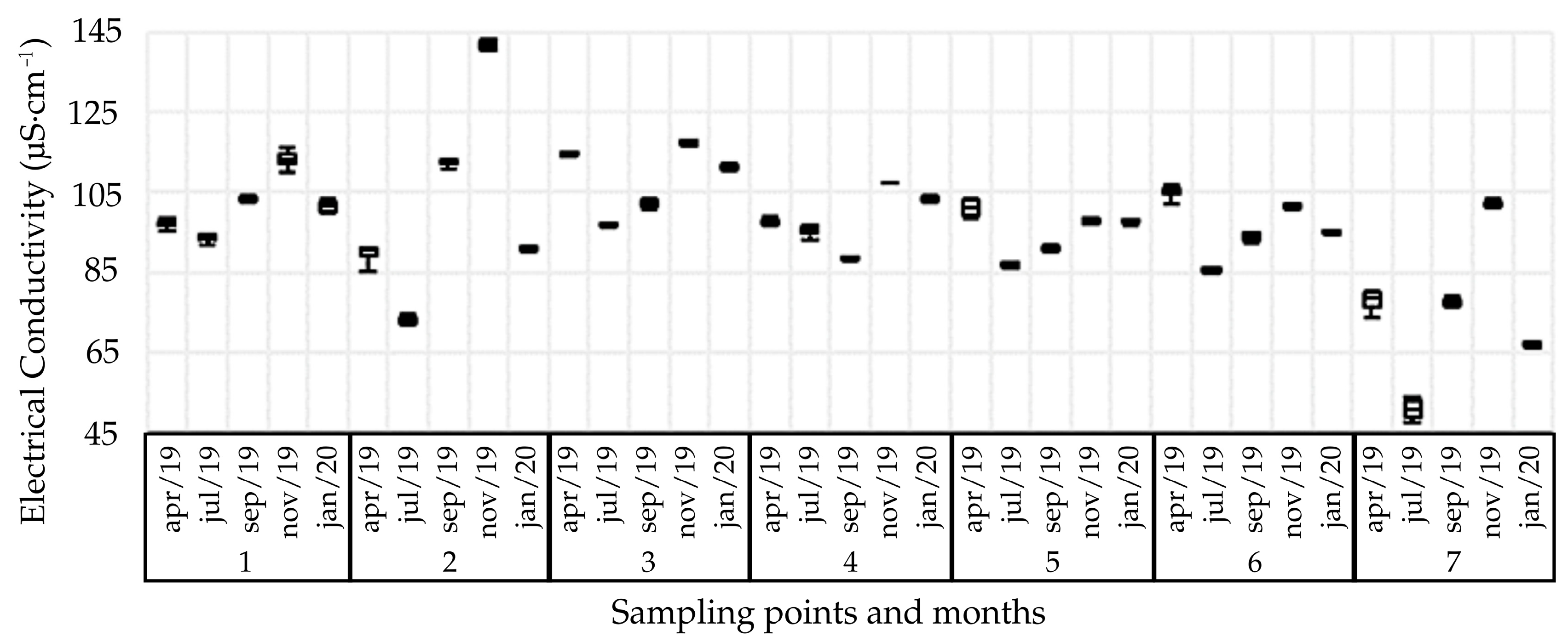
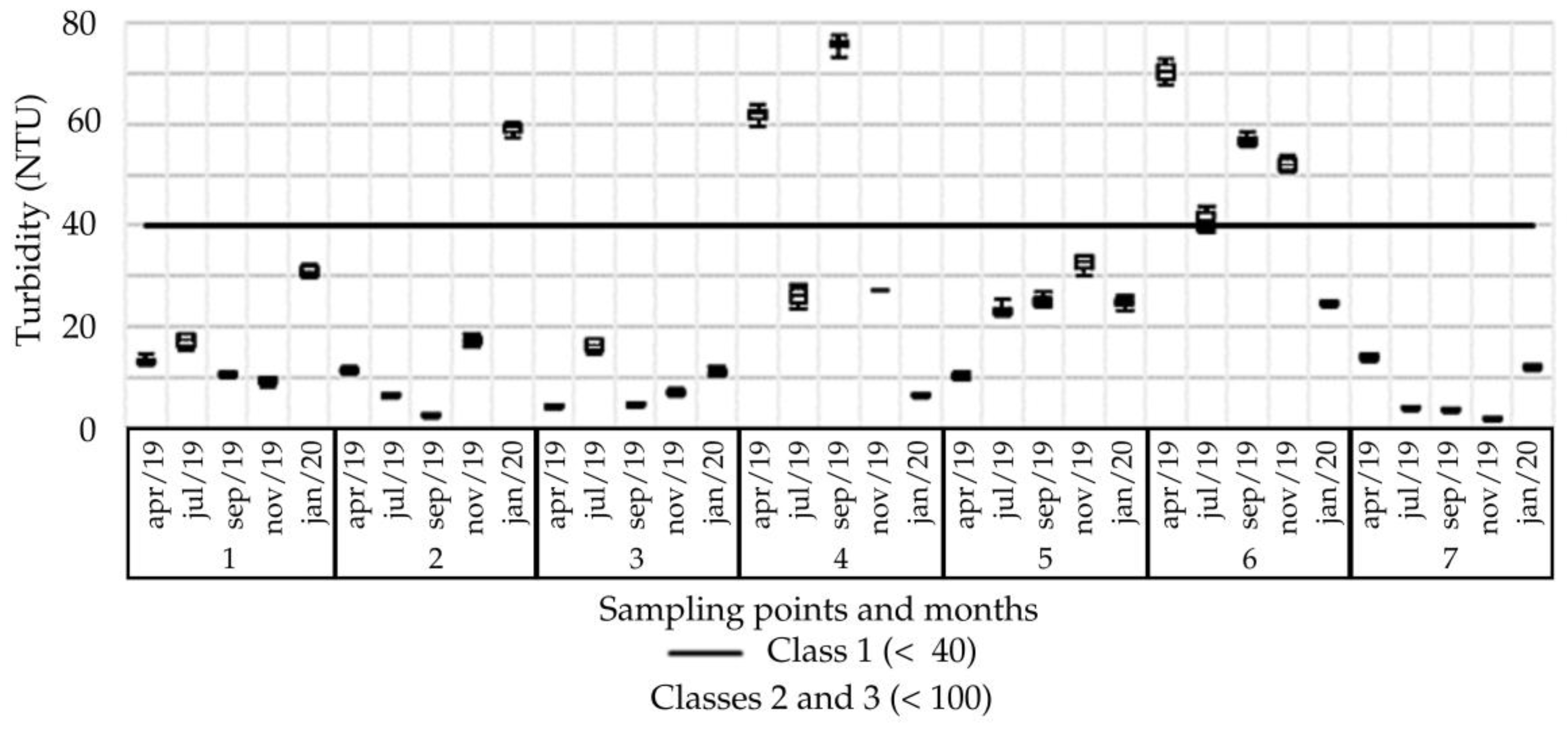
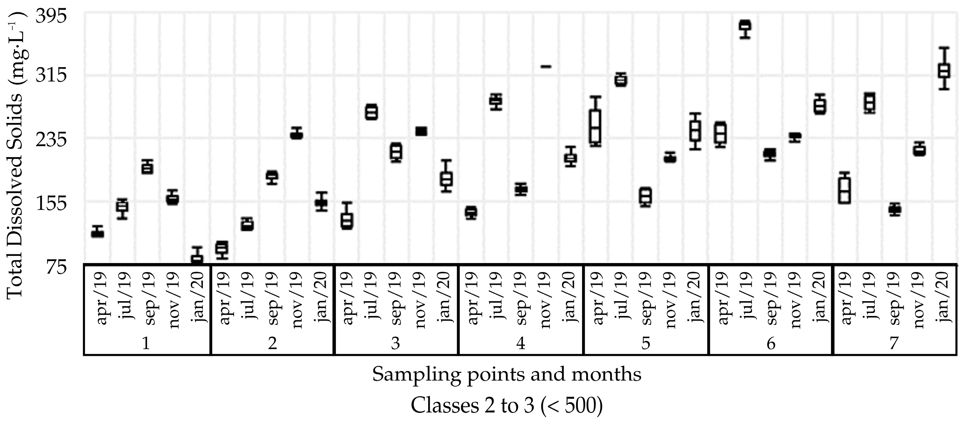
Table 2 presents the descriptive statistics and Tukey test for electrical conductivity, turbidity, total dissolved solids, total phosphorus, and total nitrogen. To assist in the discussion, Figure 7, Figure 8, Figure 9 and Figure 10 show the boxplot distribution of those parameters, respectively.
As for temperature, electrical conductivity does not have a limit defined by CONAMA Resolution 357/05 [26]; however, [39] reports that natural waters usually have conductivity levels between 10 and 100 μS·cm−1, and in environments polluted by domestic or industrial effluents, the values can reach up to 1000 μS·cm−1.
Figure 7 and Table 2 show that point 3 (Sewer amount) has the highest value for electrical conductivity, with an average of 108.5 μS·cm−1 and low variation between samples. Point 7, whose sample average was the lowest at 75.17 μS·cm−1, showed greater variability between the samples. Still, in the temporal analysis, the lowest conductivity value was found in the month when there was no precipitation, 83.29 μS·cm−1.
In a space-time assessment of the waters of the tributaries of the Barra dos Coqueiros hydroelectric plant reservoir in Goiás, the authors found conductivity levels between 10.5 μS·cm−1 and 135.8 μS·cm−1 and ascribed the values found to local lithological factors [40]. Twenty-five points were analyzed in the das Velhas’ River in Minas Gerais and EC values above 100 μS·cm−1 in all data were obtained [41]. This result can be attributed to the fact that the points are in areas where land use is intensive, which favors the transport of dissolved solids to water bodies and a consequent increase in conductivity. In a study of water quality in watersheds with different land uses in the region of Cunha, São Paulo, the authors found that the average values of electrical conductivity in forested watersheds were less than 20 μS·cm−1 [42]. While the presence or absence of riparian vegetation is important, temperature, the total volume of water flow, and the geology of the area also influence this parameter, thus accounting for its lack of standardization [43].
For the turbidity parameter, Figure 8 shows the predominance of the classification of samples as Class 1 according to CONAMA Resolution 357/05 [26]: 80% of the samples have turbidity below 40 NTU. Only 20% of the sample data, of which 80% relate to samples collected in point 6, are categorized as Class 2, whose resolution stipulates a maximum limit of 100 NTU. The average values found for points 3 and 7 are slightly close, with a point average of less than 10 NTU. This configuration reflects that the role of the riparian forest in containing solids that could reach the body of water is fundamental to reducing turbidity [44]. In contrast, point 6 presented the highest observed value in the spatial average, at 48.92 NTU. It is a point with no tree/shrub vegetation cover, and is in a grassland area, which contributes to greater sediment transport to the water body. A study of the water quality of microbasins with different land uses in the Cunha region found that the values of temperature, turbidity, and apparent water color in agricultural recharge areas were higher than those recorded in forested recharge areas [42], which was also observed in this study.
In the temporal analysis, Table 2 shows the lowest turbidity rates in the July 2019 sample due to the absence of precipitation. However, the month with the highest average—April 2019, 26.5 NTU—does not correspond, as expected, to the month with the highest accumulated precipitation. This fact was also confirmed in the study of the Amazon River [45] and in the study of rivers in the south-central region of Paraná [46].
The TDS values obtained for the sampled points, as shown in Figure 9, are all below the limit of 500 mg·L−1 established by CONAMA Resolution 357/05 [26], and also the limit of 1000 mg·L−1 established by Consolidation Ordinance no. 5/2017 of the Ministry of Health [28]. Table 2 shows values close to data variability when analyzing spatial and temporal factors, so that the coefficient obtained for the points fluctuated between 23.1% for point 5 and 34.9% for point 2, and between 14.7% for the September sample and 37.49% for the July sample. The greatest variability of the variable occurred in the dry season—July 2019 [47].
In the average of samples, point 1 presented the lowest TDS value (141.3 mg·L−1), according to the Tukey test, which was attributed to the degree of preservation of its riparian forest that allows less sediment transport to the water body. In contrast, point 6 had the highest TDS content (269.5 mg·L−1). This point showed a higher value for turbidity, and these parameters are positively related [48].
The grassland areas, such as the location of point 6, although managed and with soil cover, are characterized by lower values of water infiltration in the soil, hydraulic conductivity, and greater resistance to penetration in relation to natural vegetation, all of which tend to delay runoff and consequently the entrainment of solids [49]. They point out that the increase in the concentration of solids in the water starts in the agricultural areas, which, in the absence of proper conservation management, become major potential sources of sediment [50]. There was no statistically significant difference between points 4 and 5, located in the pasture area and with TDS averages around 231 mg·L−1.
Consolidation Ordinance No. 5/2017 of the Ministry of Health [28] establishes the absence of total coliforms in 100 mL of water (for human consumption or treated water), either at the treatment outlet or in the distribution system, to ensure its potability according to the microbiological standard; that is, in 100 mL samples collected, total coliforms must be absent. Therefore, for the sampling points, it was observed that they did not comply with the legislation, since it was noted that they showed behavior similar to one another and throughout the samplings, with a result greater than 1600 M.L.N. (Most Likely Number) per 100 mL of sample, with a 95% confidence limit [51]. Values above 1600 NMP are not detectable.
The presence of the total coliform group in natural waters does not necessarily imply contamination by fecal material, since, as established by the Water Supply Sanitary Inspection Manual [52], this group of coliforms includes bacteria that are found especially in tropical climates where their multiplication is more evident and naturally in soils, water, and plants; therefore, it is an analysis of limited sanitary value.
In a study of the Salgadinho River in the municipality of Juazeiro do Norte, 100% positivity was observed for total coliforms in the samples collected, with proportions greater than 1600 NMP·mL−1 [53], as observed in a spring in the state of Rio de Janeiro, municipality of Varre-Sai, southeastern Brazil [54]. Another study in the extreme west of Santa Catarina, southern Brazil, showed that 64.1% of the water samples analyzed for human consumption were contaminated with total coliforms [55]. Such findings highlighted the urgency of adopting preventive measures, as well as water treatment, to minimize the chances of occurrence of waterborne diseases.
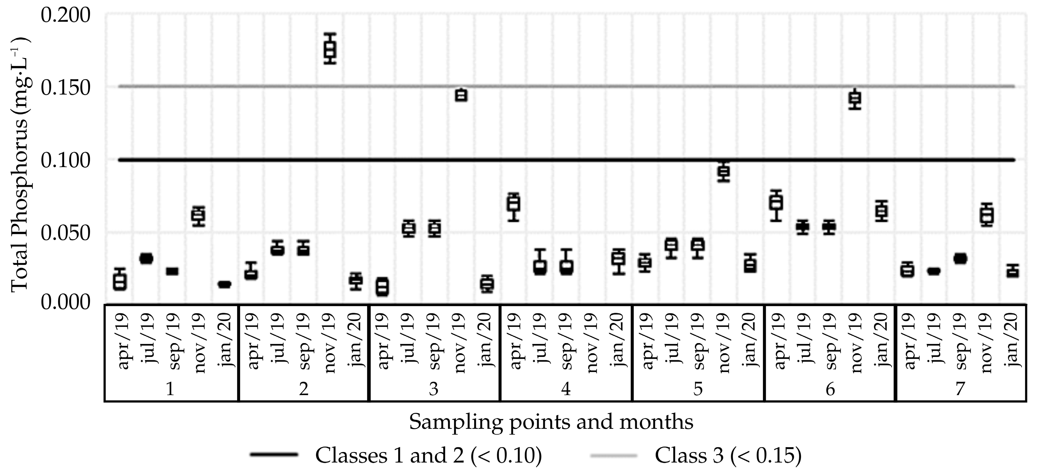
Regarding the total phosphorus content in the sample points, Figure 10 shows a predominance of classification by Class 1 and 2 according to CONAMA Resolution 357/05 [26]: 88.6% of the samples have a content of less than 0.10 mg·L−1. A total of 5.7% of the samples categorized as Class 3 (phosphorus content <0.15 mg·L−1), and only 2 samples (point 4, November 2019 and point 2, November 2019) had a content higher than 0.15 mg·L−1, although the relevant legislation does not present a limit content for Class 4.
In the analysis of temporal variation, it can be seen from Table 2 that the greatest variation of the data occurred in the April 2019 sample, with a CV of 69.26%, whose accumulated precipitation in the seven days prior to collection was the lowest, being 3.8 mm, not considering July 2019, in which previous precipitation was not accounted for. Similarly, from the analysis of Figure 10, it is noticeable that the highest concentrations for phosphorus at the sampling points were obtained in the November 2019 sampling, in which the water density at the sampling points was low, although the accumulation of previous precipitation was 19.9 mm.
In January 2020, when precipitation amounted to 86.5 mm, the lowest value for total phosphorus was verified in the study points. Therefore, there was a tendency for the parameter of total phosphorus to increase in the dry season and decline in the rainy season. This finding corroborates the results obtained in a study of supply sources in Goiânia, in a study of Ribeirão Anhumas in Campinas/SP, and in an analysis of the Atibaia and Jaguari Rivers near the city of Paulínia/SP [56,57,58], respectively.
Regarding the variability of the data in the spatial evaluation, Table 2 also shows a variation of 50.9% for point 7 and 131.7% for point 4. There was no statistically significant difference between points 1 and 7, whose averages are the lowest among the analyzed points, at 0.029 and 0.033 mg·L−1, respectively. In contrast, point 4 presented the highest total phosphorus content. Although the presence of phosphorus in the water body is commonly associated with the discharge of effluents, wastewater, or the leaching of regions where agriculture is practiced, the available phosphorus can result from the release of phosphates with the decomposition of rocks through natural weathering processes [59].
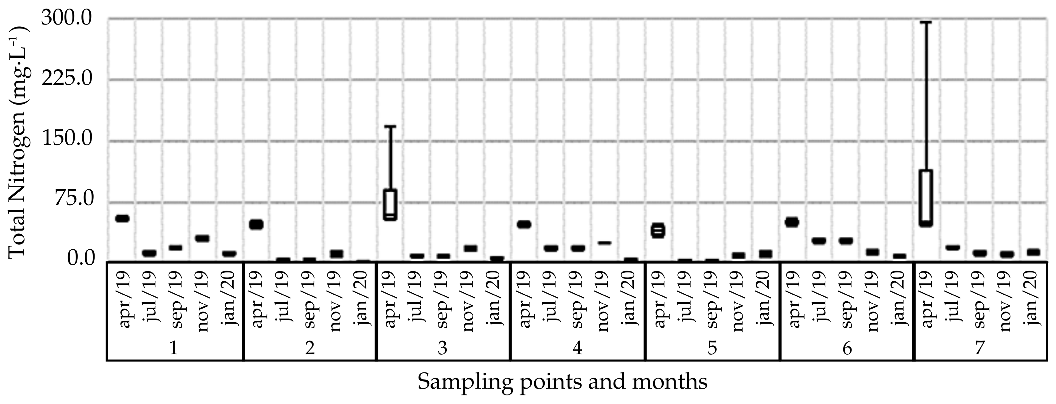
Figure 11 shows the results of the sampled points for total nitrogen. For this, the organic nitrogen content and the ammoniacal nitrogen present in water bodies are measured. In addition to this, the water body may contain nitrogen in the forms of nitrite and nitrate, which were not analyzed in this work. Only the ammoniacal form has concentration limits established according to CONAMA 357/05 [26].
As shown in Table 2, it was found that 34.29% of the data had TN content of less than 10 mg·L−1, 34.3% content between 10 and 20 mg·L−1, 14.3% concentration of TN in the range 20 to 30 mg·L−1, 11.4% between 30 and 40 mg·L−1, and 5.7% greater than 50 mg·L−1.
Although there is no limit for this parameter in CONAMA Resolution 357/05 [26], the levels obtained are higher than those reported in work carried out in natural waters, which found levels between 0.64 mg·L−1 and 0.53 mg·L−1 in rivers in the region of Cadeia do Espinhaço/MG [60]. Another example is the study in the Itamambuca River in Caraguatatuba, São Paulo, which observed a content of 0.08 mg·L−1 [61].
Although this element does not have a minimum release pattern determined by the environmental agency, it should be considered since in high concentrations it can lead to excessive growth of algae, thus causing eutrophication [62].
The metrics normally used for hydrological monitoring of ecosystem services are not easily interpreted by researchers and decision makers [16], highlighting the importance of this study as a basis for replication in other locations where the PES-Water program exists and there is difficulty in monitoring to verify results. In addition, most PES programs do not clearly define which services are provided by the area in question and are linked to payment [63], which highlights the importance of this study that proposes seasonal monitoring of water quality based on previously established parameters.

4. Conclusions

The water quality indicators obtained for the sampling points implied good quality, especially at points 1 (Fazenda Santa Margarida exit), 5 (collection for consumption), and 7 (property amount), so that the values obtained for DO, BOD, pH, turbidity, TDS, and total phosphorus met the limits for Class 1 and 2 of CONAMA Resolution 357/05.
Spatial-temporal heterogeneity of the water quality indicators was observed at the sampling points. This is borne out by the analysis of variance performed, so that for the parameters DO, BOD, pH, phosphorus, and total nitrogen, greater fluctuation was noticed in relation to the spatial location of the samples. Sampling points for the turbidity, temperature, and EC parameters also show greater variability between samples. The TDS and total coliform parameters were influenced by the same magnitude when the two evaluation criteria were analyzed.
The monitoring carried out on the property over the course of a year helped check the compliance and implementation of actions foreseen by the PES project. However, it is understood that long-term monitoring would make it possible to differentiate between the improvements found in precipitation seasonality and those arising from the actions taken on the property under the program. Therefore, this local study consolidates the significant scientific contribution regarding the monitoring time of areas used for PES in tropical and subtropical regions.
For future work, it is suggested that a spatial-temporal evaluation be adopted, as the method has proven to be efficient and suitable for hydrological monitoring of the areas participating in the PES program, especially considering seasonal changes that can significantly interfere with the quality of surface water.

Author Contributions

Conceptualization, R.M.L. and J.M.G.; methodology, J.M.G.; validation, R.M.L., J.M.G. and A.N.N.; formal analysis, J.M.G.; investigation, J.M.G.; resources, J.M.G.; data curation, J.M.G.; writing—original draft preparation J.M.G.; writing—review and editing, R.M.L., R.C.G. and A.N.N.; visualization, J.M.G.; supervision, R.M.L.; project administration, R.M.L.; funding acquisition, R.M.L. All authors have read and agreed to the published version of the manuscript.

Funding

This work was supported by the São Paulo Research Foundation—FAPESP (regular research project 2022/05062-3 and technical training 2021/03002-0) and the Coordination of Superior Level Staff Improvement—CAPES (Process 88887.691909/2022-00-Postgraduate Development Program-Strategic Postdoctoral). The authors also gratefully acknowledge the support provided by the Centre for Studies in Geography and Spatial Planning (CEGOT), financed by national funds through the Foundation for Science and Technology (FCT), under the reference UIDB/04084/2020.

Data Availability Statement

The data supporting this study’s findings are openly available at https://github.com/ra-gomes/spatial-temporal-monitoring-wq/blob/2f9164741df1cd689b4d3f5051d4aeedfdf2c5d7/tables%20excel%20water%20quality.xlsx, accessed on 17 September 2024.

Acknowledgments

The authors hereby acknowledge the Pontifical Catholic University of Campinas for providing the necessary infrastructure to carry out this study.

Conflicts of Interest

The authors declare no conflicts of interest.

References

  1. Araújo, I.S.; Maciel, A.B.C.; Ferreira, J.C.V.; Lima, Z.M.C. Identificação de serviços ecossistêmicos na praia de Ponta Negra, Natal-RN. Rev. Geociências Do Nordeste 2018, 4, 298–313. [Google Scholar] [CrossRef]
  2. Burkhard, B.; Kandziora, M.; Hou, Y.; Müller, F. Ecosystem service potential, flows and demands-concepts for spatial localisation, indication and quantification. Landsc. Online 2014, 34, 1–32. [Google Scholar] [CrossRef]
  3. Castro, B.S.; Young, C.E.F.; Pereira, V.S. Iniciativas estaduais de Pagamentos por Serviços Ambientais: Análise legal e seus resultados. Rev. Iberoam. Econ. Ecológica 2018, 28, 44–71. [Google Scholar]
  4. Mamedes, I.; Guerra, A.; Rodrigues, D.B.B.; Garcia, L.C.; de Faria Godoi, R.; Oliveira, P.T.S. Brazilian payment for environmental services programs emphasize water-related services. In International Soil and Water Conservation Research; KeAi Communications Co.: Beijing, China, 2023; Volume 11, pp. 276–289. [Google Scholar] [CrossRef]
  5. Gregori, M.S. Limites e possibilidades do sistema de Pagamento por Serviços Ambientais como instrumento de promoção da sustentabilidade socioambiental no Brasil. Ph.D. Thesis, Universidade Federal de Santa Maria, Santa Maria, Brazil, 2017. [Google Scholar]
  6. Calvet-Mir, L.; Corbera, E.; Martin, A.; Fisher, J.; Gross-Camp, N. Payments for ecosystem services in the tropics: A closer look at effectiveness and equity. Curr. Opin. Environ. Sustain. 2015, 14, 150–162. [Google Scholar] [CrossRef]
  7. Huang, Y.; Zhang, X.; Sheng, X.; Wang, Y.; Leung, K.M.Y. The impact of payment for ecosystem service schemes on participants’ motivation: A global assessment. Ecosyst. Serv. 2024, 65, 101595. [Google Scholar] [CrossRef]
  8. Martin-Ortega, J.; Ojea, E.; Roux, C. Payments for water ecosystem services in Latin America: A literature review and conceptual model. Ecosyst. Serv. 2013, 6, 122–132. [Google Scholar] [CrossRef]
  9. Grima, N.; Singh, S.J.; Smetschka, B.; Ringhofer, L. Payment for ecosystem services (PES) in Latin America: Analysing the performance of 40 case studies. Ecosyst. Serv. 2016, 17, 24–32. [Google Scholar] [CrossRef]
  10. Chiodi, R.E.; Marques, P.E.M. Políticas públicas de pagamento por serviços ambientais para a conservação dos recursos hídricos: Origens, atores, interesses e resultados da ação institucional. Desenvolv. E Meio Ambiente 2018, 45, 81–104. [Google Scholar] [CrossRef]
  11. Jardim, M.H.; Bursztyn, M.A. Pagamento por serviços ambientais na gestão de recursos hídricos: O caso de Extrema (MG). Eng. Sanit. Ambient. 2015, 20, 353–360. [Google Scholar] [CrossRef]
  12. Guedes, F.B.; Seehusen, S.E. (Eds.) O PSA na Mata Atlântica—Situação Atual, Desafios e Recomendações; Ministério do Meio Ambiente: Brasília, Brazil, 2011. [Google Scholar]
  13. Balvanera, P.; Uriarte, M.; Almeida-Leñero, L.; Altesor, A.; DeClerck, F.; Gardner, T.; Hall, J.; Lara, A.; Laterra, P.; Peña-Claros, M.; et al. Ecosystem services research in Latin America: The state of the art. Ecosyst. Serv. 2012, 2, 56–70. [Google Scholar] [CrossRef]
  14. Arriagada, R.A.; Sills, E.O.; Ferraro, P.J.; Pattanayak, S.K. Do payments pay off? Evidence from participation in Costa Rica’s PES program. PLoS ONE 2015, 10, e0131544. [Google Scholar]
  15. Bennett, G.; Carroll, N. Gaining Depth: State of Watershed Investment 2014; Forest Trends: Washington, DC, USA, 2014; Available online: https://www.foresttrends.org/publications/gaining-depth-2/ (accessed on 13 March 2020).
  16. Ureta, J.U.; Ureta, J.C.; Bower, L.M.; Peoples, B.K.; Motallebi, M. The value of improving freshwater ecosystem services: South Carolina residents’ willingness to pay for improved water quality. J. Environ. Manag. 2024, 353, 120260. [Google Scholar] [CrossRef] [PubMed]
  17. Campinas. Lei no. 15.046 de 23 de Julho de 2015. Institui o Programa de Pagamento por Serviços Ambientais, Autoriza o Poder Executivo Municipal a Prestar Apoio aos Proprietários Rurais e Urbanos Determinados pelo Programa, e dá Outras Providências. Campinas, SP. Diário Oficial do Município. Available online: https://portal-api.campinas.sp.gov.br/sites/default/files/publicacoes-dom/dom/2062178756.pdf (accessed on 17 September 2024).
  18. Campinas. Decreto Municipal no. 19.441 de 15 de Março de 2017. Regulamenta o Subprograma de Pagamento pela Conservação das Águas e dos Recursos Hídricos-PSA Água, Instituído pela Lei nº 15.046, de 23 de Julho de 2015. Campinas, SP. Diário Oficial do Município. Available online: https://bibliotecajuridica.campinas.sp.gov.br/index/visualizaroriginal/id/130978 (accessed on 17 September 2024).
  19. SVDS. Secretaria Municipal do Verde, Meio Ambiente e Desenvolvimento Sustentável. GEOAMBIENTAL: Informações Ambientais Espacializadas. Recuperado em 14 de maio de 2020. Available online: https://geoambiental.campinas.sp.gov.br/pmapper/map_svds.phtml?config=svds (accessed on 17 September 2024).
  20. Taffarello, D.; do Carmo, C.M.; Viani, R.A.G.; Marengo, J.A.; Mendiondo, E.M. Hydrological services in the Atlantic Forest, Brazil: An ecosystem-based adaptation using ecohydrological monitoring. Clim. Serv. 2017, 8, 1–16. [Google Scholar] [CrossRef]
  21. Izquierdo-Tort, S.; Alatorre, A.; Arroyo-Gerala, P.; Shapiro-Garza, E.; Naime, J.; Dupras, J. Exploring local perceptions and drivers of engagement in biodiversity monitoring among participants in payments for ecosystem services schemes in southeastern Mexico. Conserv. Biol. 2024, 38, e14282. [Google Scholar] [CrossRef] [PubMed]
  22. Young, C.E.F.; de Bakker, L.B. Payments for ecosystem services from watershed protection: A methodological assessment of the Oasis Project in Brazil. Nat. Conserv. 2014, 12, 71–78. [Google Scholar] [CrossRef]
  23. Brownson, K.; Fowler, L. Evaluating how we evaluate success: Monitoring, evaluation and adaptive management in Payments for Watershed Services programs. Land Use Policy 2020, 94, 104505. [Google Scholar] [CrossRef]
  24. Longo, R.M.; Garcia, J.M.; Gomes, R.C.; Nunes, A.N. Identifying Key Indicators for Monitoring Water Environmental Services Payment Programs—A Case Study in Brazil. Sustainability 2023, 15, 9593. [Google Scholar] [CrossRef]
  25. Fiore, F.A.; Bardini, V.S.S.; Novaes, R.C. Monitoramento da qualidade de águas em programas de pagamento por serviços ambientais hídricos: Estudo de caso no município de São José dos Campos/SP. Eng. Sanit. Ambient. 2017, 22, 1141–1150. [Google Scholar] [CrossRef]
  26. Brasil. Conselho Nacional do Meio Ambiente–CONAMA. Resolução CONAMA nº357, de 17 de março de 2005. Dispõe Sobre a Classificação dos Corpos de Água e Diretrizes Ambientais para seu Enquadramento, bem Como Estabelece as Condições e Padrões de Lançamento de Efluentes, e dá Outras Providências; Diário Oficial [da] República Federativa do Brasil: Brasília, Brazil, 2005. [Google Scholar]
  27. Brasil. Ministério da Saúde. Portaria n°2.914, de 12 de dezembro de 2011. Dispõe Sobre os Procedimentos de Controle e de Vigilância da Qualidade da Água para Consumo Humano e seu Padrão de Potabilidade; Diário Oficial [da] República Federativa do Brasil: Brasília, Brazil, 2011. [Google Scholar]
  28. Brasil. Ministério da Saúde. Anexo XX: Do Controle e da Vigilância da Qualidade da Água para Consumo Humano e seu Padrão de Potabilidade. Portaria de Consolidação n° 5, de 28 de Setembro de 2017. Consolidação das Normas sobre as ações e os Serviços de Saúde do Sistema Único de Saúde; Diário Oficial [da] República Federativa do Brasil: Brasília, Brazil, 2017. [Google Scholar]
  29. CIIAGRO. Centro Integrado de Informações Agrometeorológicas. CIIAGRO online. Recuperado em 20 de outubro de 2020. Available online: http://www.ciiagro.sp.gov.br/ciiagroonline/ (accessed on 20 October 2020).
  30. Valladares Neto, J.; Santos, C.B.; Torres, E.M.; Estrela, C. Boxplot: Um recursos gráfico para a análise e interpretação de dados quantitativos. Rev. Odontológica Do Bras. Cent. 2017, 26, 1–6. [Google Scholar]
  31. Canteri, M.G. SASM-AGRI: Sistema para análise e separação de médias em experimentos agrícolas pelos métodos Scott-Knott, Tukey e Duncan. Rev. Bras. Agrocomputação 2001, 1, 18–24. [Google Scholar]
  32. Villa, M.E.C.D.; Sampaio, T.V.M. Variabilidade espacial e temporal dos parâmetros físico-químico em ambiente lêntico. Bol. De Geogr. 2016, 34, 69–80. [Google Scholar] [CrossRef]
  33. Oliveira, C.N.; Campos, V.P.; Medeiros, Y.D.P. Avaliação e identificação de parâmetros importantes para a qualidade de corpos d’água no semiárido baiano. Estudo de caso: Bacia hidrográfica do Rio Salitre. Química Nova 2010, 33, 1059–1066. [Google Scholar] [CrossRef]
  34. Poersch, A.C.C.; Sebastien, N.Y.; Taborda, J.; Colombari Neto, J.; Caovilla, M.M.; Fonseca, C.A. A demanda bioquímica de oxigênio (DBO) e possíveis fatores de influência nos processos em águas superficiais do Rio São Francisco Verdadeiro–Paraná. Acta Iguazu 2019, 8, 45–51. [Google Scholar]
  35. Garcia, J.M.; Longo, R.M. Análise de impactos ambientais em Área de Preservação Permanente (APP) como instrumento de gestão em rios urbanos. Cerrados (UNIMONTES) 2020, 18, 107–128. [Google Scholar] [CrossRef]
  36. Esteves, F.A. Fundamentos de Limnologia, 2nd, ed.; Editora Interciência: Rio de Janeiro, Brazil, 1998. [Google Scholar]
  37. Sisinno, C.L.S.; Moreira, J.C. Avaliação da contaminação e poluição ambiental na área de influência do aterro controlado do Morro do Céu, Niterói, Brasil. Cad. De Saúde Pública 1996, 12, 515–523. [Google Scholar] [CrossRef] [PubMed]
  38. Lamparelli, C.C. Dinâmica da Serapilheira em Manguezais de Bertioga, Região Sudeste do Brasil. Ph.D. Thesis, Universidade de São Paulo, São Paulo, Brazil, 1995. [Google Scholar]
  39. Von Sperling, M. Introdução à Qualidade das Águas e ao Tratamento de Esgotos, 3rd, ed.; Editora UFMG: Belo Horizonte, Brazil, 2005. [Google Scholar]
  40. Rocha, H.M.; Cabral, J.B.P.; Braga, C.C. Avaliação espaço-temporal das águas dos afluentes do Reservatório da UHE Barra dos Coqueiros/Goiás. Rev. Bras. De Recur. Hídricos 2014, 19, 131–142. [Google Scholar] [CrossRef]
  41. Baggio, H.; Freitas, M.O.; Araújo, A.D. Análises dos parâmetros físico-químicos oxigênio dissolvido, condutividade elétrica, potencial hidrogeniônico e temperatura, suas correlações com o uso e ocupação da terra no baixo curso do Rio das Velhas-MG. Caminhos De Geogr. 2016, 17, 105–117. [Google Scholar] [CrossRef]
  42. Arcova, F.C.S.; Cicco, V. Qualidade da água de microbacia com diferentes usos do solo na região de Cunha, Estado de São Paulo. Sci. For. 1999, 56, 125–134. [Google Scholar]
  43. Marmontel, C.V.F.; Rodrigues, V.A. Parâmetros indicativos para qualidade da água em nascentes com diferentes coberturas de terra e conservação da vegetação ciliar. Floresta Ambiente 2015, 22, 171–181. [Google Scholar] [CrossRef]
  44. Donadio, N.M.M.; Galbiatti, J.A.; De Paula, R.C. Qualidade da água de nascentes com diferentes usos do solo na bacia hidrográfica do córrego Rico, São Paulo, Brasil. Eng. Agrícola 2005, 25, 115–125. [Google Scholar] [CrossRef]
  45. Damasceno, M.C.S.; Ribeiro, H.M.C.; Takiyama, L.R.; De Paula, M.T. Avaliação sazonal da qualidade das águas superficiais do Rio Amazonas na orla da cidade de Macapá, Amapá, Brasil. Ambiente E Água 2015, 10, 598–613. [Google Scholar] [CrossRef]
  46. Branco, C.C.Z.; Krupek, R.A.; Peres, C.K. Variação sazonal de alguns parâmetros físicos e químicos em três rios pertencentes a uma bacia de drenagem na região centro-sul do Estado do Paraná, Sul do Brasil. Acta Sci. Biol. Sci. 2008, 30, 431–438. [Google Scholar] [CrossRef]
  47. Soares, R.D.B.; Cruz, R.W.L.; Silva, C.E. A influência da precipitação na variabilidade da qualidade da água do rio Parnaíba. Braz. J. Dev. 2019, 5, 16643–16672. [Google Scholar] [CrossRef]
  48. Fonseca, H.S.; Salvador, N.N.B. Estudo integrado da qualidade das águas da bacia hidrográfica do Rio Bonito em Descalvado-SP. Rev. Do Inst. Adolfo Lutz 2005, 64, 179–185. [Google Scholar] [CrossRef]
  49. Silva, D.D.; Pruski, F.F.; Schaefer, C.E.G.R.; Amorim, R.S.S.; Paiva, K.W.N. Efeito da cobertura nas perdas de solo em um Argissolo Vermelho-Amarelo utilizando simulador de chuva. Eng. Agrícola 2005, 25, 409–419. [Google Scholar] [CrossRef]
  50. Vanzela, L.S.; Hernandez, F.B.T.; Franco, R.A.M. Influência do uso e ocupação do solo nos recursos hídricos do Córrego Três Barras, Marinópolis. Rev. Bras. De Eng. Agrícola E Ambient. 2010, 14, 55–64. [Google Scholar] [CrossRef]
  51. FUNASA. Fundação Nacional de Saúde. Manual Prático de Análise de Água, 4th ed.; FUNASA: Brasília, Brazil, 2013; 150p. [Google Scholar]
  52. Brasil. Ministério da Saúde. Secretaria de Vigilância em Saúde. Inspeção Sanitária em Abastecimento de Água; Ministério da Saúde: Brasília, Brazil, 2007. [Google Scholar]
  53. Nunes, L.M. Pesquisa de coliformes totais e termotolerantes no rio Salgadinho no município de Juazeiro do Norte, CE. Rev. Eletrônica Acervo Científico 2019, 7, e2243. [Google Scholar] [CrossRef]
  54. Santos, E.P.P.; Veiga, W.A.; Gonçalves, M.R.S.; Thomé, M.P.M. Coliformes Totais e Termotolerantes em água de nascentes utilizadas para o consumo humano na zona rural do município de Varre-Sai, RJ. Sci. Plena 2015, 11, 052401. [Google Scholar]
  55. Scapin, D.; Rossi, E.M.; Oro, D. Qualidade microbiológica da água utilizada para consumo humano na região do extremo oeste de Santa Catarina, Brasil. Rev. Inst. Adolfo Lutz 2012, 71, 593–596. [Google Scholar] [CrossRef]
  56. Santos, A.A.; Silva, D.P.; Costa, I.A.; Cuba, R.M.F. Avaliação sazonal de índices de estado trófico para fósforo total para mananciais de abastecimento público do Município de Goiânia, Estado do Goiás, Brasil. Rev. Bras. De Gestão Ambient. E Sustentabilidade 2019, 6, 883–895. [Google Scholar] [CrossRef]
  57. Hossomi, A.M.T. Avaliação Temporal (2006 a 2016) da Qualidade de Água do Ribeirão Anhumas–Campinas/SP; (Monografia de Especialização); Escola Superior de Agricultura Luiz de Queiroz ESALQ/USP: Piracicaba, Brazil, 2017. [Google Scholar]
  58. Leite, D.A.N.O.; Ramos, M.A.G.; Godói, D.R.; Mariano, A.P.; Pião, A.C.S.; Angelis, D.F. Avaliação dos parâmetros do índice de Qualidade de Água segundo o modelo estatístico ARIMA. HOLOS Environ. 2013, 13, 24–39. [Google Scholar] [CrossRef]
  59. Souza, F.A.R. Modelagem Espacial da Qualidade da Água Usando Geotecnologias na Bacia Hidrográfica de Santana-RJ. Dissertação de Mestrado, Universidade Federal do Rio de Janeiro, Rio de Janeiro, Brazil, 2017.
  60. Meyer, S.T.; Franceschinelli, E.V. Influência de variáveis limnológicas sobre a comunidade das macrófitas aquáticas em rios e lagoas da Cadeia do Espinhaço, Minas Gerais, Brasil. Rodriguésia 2011, 62, 743–758. [Google Scholar] [CrossRef]
  61. Carvalho, A.R.; Marinho, A.M.; Silva, A.C.R.S.; Bernardes, M.E.C. Comparação entre os Índices de Qualidade da Água (IQA) dos estuários dos rios Itamambuca e Juqueriquerê–litoral norte de São Paulo–sob mesma sazonalidade. In Anais do IV Congresso Brasileiro de Gestão Ambiental; IBEAS: Salvador, Brazil, 2013. [Google Scholar]
  62. Barbieri, E.; Marques, H.L.A.; Bondioli, A.C.V.; Campolim, M.B.; Ferrarini, A.T. Concentrações do nitrogênio amoniacal, nitrito e nitrato em áreas de engorda de ostras no município de Cananeia-SP. O Mundo Da Saúde 2014, 38, 105–115. [Google Scholar] [CrossRef]
  63. Mota, P.K.; da Costa, A.M.; Prado, R.B.; Fernandes, L.F.S.; Pissarra, T.C.T.; Pacheco, F.A.L. Payment for Environmental Services: A critical review of schemes, concepts, and practice in Brazil. In Science of the Total Environment; Elsevier B.V.: Amsterdam, The Netherlands, 2023; Volume 899. [Google Scholar] [CrossRef]
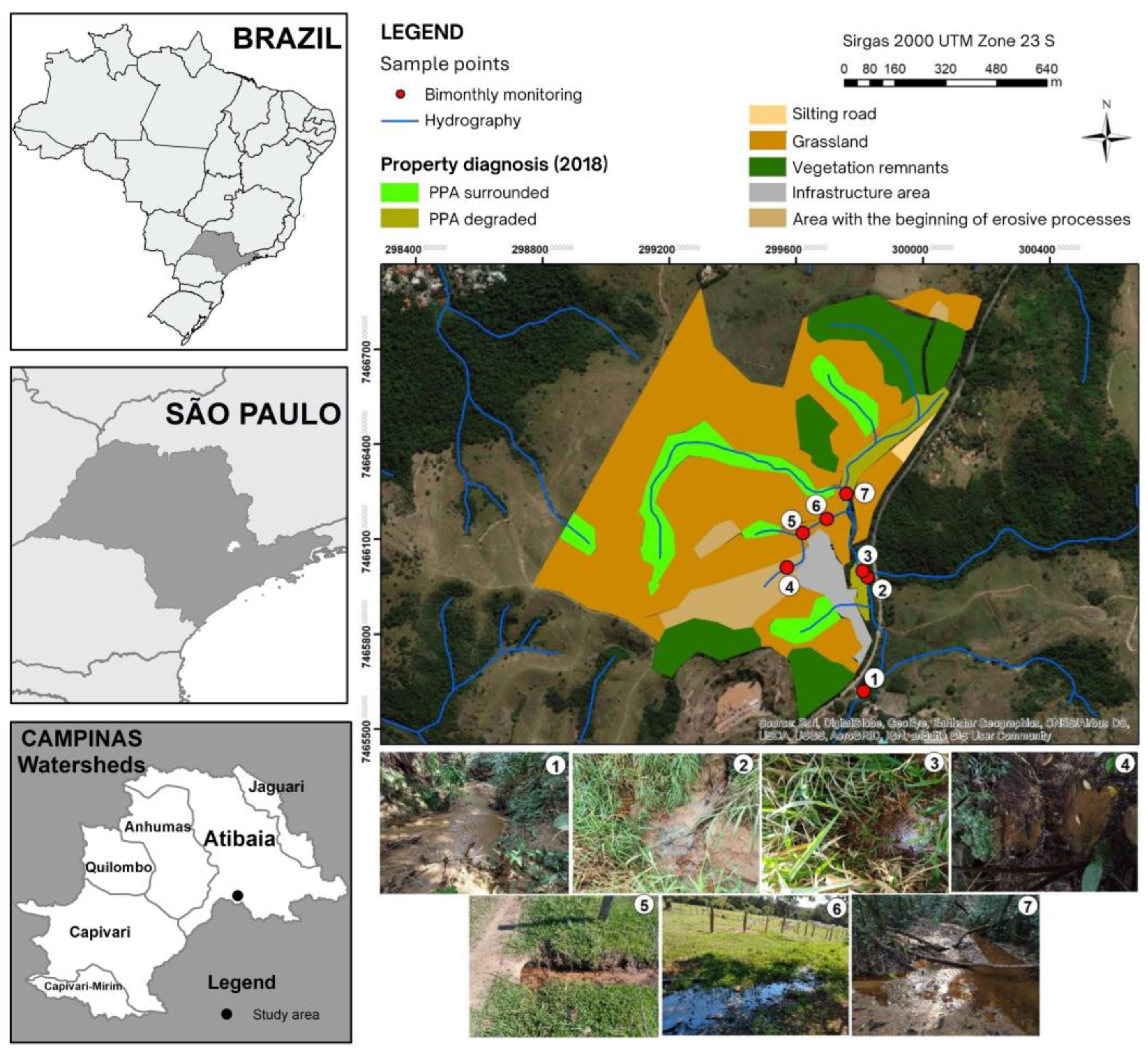
Figure 1. Sample points at the study property, Campinas, São Paulo [20].
Water 16 03673 g001
Figure 2. Climatic data in the municipality of Campinas during the study period. (Authors’ own.)
Water 16 03673 g002
Figure 3. Descriptive analysis for the indicators dissolved oxygen—OD (mg·L−1). (Authors’ own).
Water 16 03673 g003
Figure 4. Descriptive analysis for the indicators biochemical oxygen demand—BOD (mg·L−1). (Authors’ own).
Water 16 03673 g004
Figure 5. Descriptive analysis of the indicator pH, (Authors’ own).
Water 16 03673 g005
Figure 6. Descriptive analysis for the indicator temperature (°C), (Authors’ own).
Water 16 03673 g006
Figure 7. Descriptive analysis for the indicator electrical conductivity (μS·cm−1), (Authors’ own).
Water 16 03673 g007
Figure 8. Descriptive analysis for the indicator turbidity (NTU). (Authors’ own.)
Water 16 03673 g008
Figure 9. Descriptive analysis for the indicator total dissolved solids (mg·L−1), (Authors’ own).
Water 16 03673 g009
Figure 10. Descriptive analysis for the indicator total phosphorus (mg·L−1), (Authors’ own).
Water 16 03673 g010
Figure 11. Descriptive analysis for the total nitrogen indicator (mg·L−1), (Authors’ own).
Water 16 03673 g011
Table 1. Descriptive statistics and Tukey test for dissolved oxygen, biochemical oxygen demand, pH, and temperature parameters (authors’ own).
PointApr 2019Jul 2019Sep 2019Nov 2019Jan 2020AverageSDCV (%)
Dissolved Oxygen (mg·L−1)
16.66 cB4.30 bB6.80 dB7.41 aB7.89 aB6.611.3820.91
27.82 cB3.27 bB7.44 dB7.14 aB7.00 aB6.531.8528.36
37.33 cA3.08 bA7.01 dA6.96 aA6.66 aA6.211.7628.42
45.86 cD2.86 bD5.89 dD6.18 aD7.45 aD5.651.6929.88
54.81 cC3.08 bC5.33 dC6.51 aC6.19 aC5.181.3626.21
67.06 cA2.80 bA7.18 dA7.23 aA6.86 aA6.221.9230.83
76.68 cA3.21 bA7.43 dA7.04 aA6.52 aA6.181.6927.41
Average6.603.236.736.926.94---
SD1.000.500.810.430.58---
CV (%)15.1415.5612.076.218.30---
Biochemical Oxygen Demand (mg·L−1)
12.93 cD1.38 aD4.49 eD3.88 bD4.28 dD3.391.2737.50
24.14 cBC0.90 aBC5.08 eBC2.58 bBC3.19 dBC3.181.5949.92
33.84 cB0.90 aB4.83 eB2.31 bB3.53 dB3.081.5249.17
42.90 cA0.97 aA4.00 eA2.13 bA4.55 dA2.911.4449.32
51.98 cE0.95 aE3.20 eE3.65 bE2.99 dE2.551.0942.60
63.69 cCD0.99 aCD5.36 eCD3.14 bCD3.33 dCD3.301.5647.39
73.15 cA0.90 aA4.51 eA2.6 bA2.72 dA2.781.3046.65
Average3.231.004.492.903.51---
SD0.730.170.720.670.67---
CV (%)22.5117.3716.0823.1619.11---
pH
17.48 abD7.44 aD7.25 bD7.63 dD6.96 cD7.350.263.49
27.21 abC6.82 aC7.37 bC7.90 dC6.99 cC7.260.415.70
37.02 abBC7.10 aBC7.51 bBC7.57 dBC6.81 cBC7.200.334.54
46.85 abA6.92 aA7.06 bA7.44 dA6.95 cA7.040.243.35
57.14 abA6.91 aA6.82 bA7.49 dA7.12 cA7.090.263.66
67.06 abB7.01 aB7.35 bB7.48 dB7.02 cB7.180.223.02
76.95 abA7.21 aA6.71 bA7.32 dA7.16 cA7.070.243.44
Average7.107.067.157.557.00---
SD0.210.210.300.180.11---
CV (%)2.913.044.202.411.64---
Temperature (°C)
120.43 dC21.25 bcC20.08 abC21.55 cC20.08 aC20.680.693.31
218.58 dA19.03 bcA19.28 abA19.98 cA19.05 aA19.180.512.67
320.53 dD21.03 bcD21.23 abD21.70 cD20.80 aD21.060.442.11
419.50 dB20.15 bcB19.98 abB20.50 cB20.03 aB20.030.361.80
518.75 dA19.33 bcA18.78 abA18.98 cA18.93 aA18.950.231.22
621.25 dE21.75 bcE21.85 abE21.98 cE21.80 aE21.730.281.28
720.00 dB20.60 bcB20.85 abB19.63 cB20.28 aB20.270.482.38
Average19.8620.4520.2920.6120.14---
SD0.981.011.091.150.99---
CV (%)4.924.925.365.604.92---
1. Downstream property; 2. Native forest; 3. Sewer amount; 4. Erosive process; 5. Consumption—nascent; 6. Livestock interference; 7. Property amount. The data used were taken from the first author’s master’s dissertation. The results are expressed by an average of four repetitions. SD—standard deviation; CV—coefficient of variation. Means followed by the same lowercase letter do not differ significantly from each other by the Tukey test at a 5% probability in relation to the sampling time. Means followed by the same capital letter do not differ significantly by the Tukey test at a 5% probability in relation to the sampling location.
Table 2. Descriptive statistics and Tukey test for the parameters electrical conductivity, turbidity, total dissolved solids, total phosphorus, and total nitrogen. (Authors’ own.)
PointApr 2019Jul 2019Sep 2019Nov 2019Jan 2020AverageSDCV (%)
Electrical Conductivity (μS·cm−1)
197.03 cA93.68 bA103.40 aA113.30 dA101.63 aA101.817.487.35
289.40 cA73.13 bA112.38 aA141.83 dA91.08 aA101.5626.4826.07
3114.63 cF96.88 bF102.28 aF117.53 dF111.43 aF108.558.688.00
497.75 cE95.55 bE88.33 aE107.30 dE103.58 aE98.507.357.46
5101.20 cC87.03 bC91.20 aC97.95 dC97.70 aC95.025.756.06
6105.18 cD85.80 bD94.00 aD101.48 dD94.98 aD96.297.467.75
777.85 cB50.98 bB77.73 aB102.33 dB66.95 aB75.1718.7424.93
Average97.5883.2995.61111.6795.33---
SD11.6816.3811.4114.9714.12---
CV (%)11.9719.6711.9313.4114.81---
Turbidity (NTU)
113.37 eC17.21 aC10.58 dC9.30 bC30.98 cC16.298.7553.76
211.52 eD6.51 aD2.61 dD17.45 bD59.08 cD19.4322.85117.57
34.36 eB16.33 aB4.56 dB7.25 bB11.13 cB8.735.0657.93
461.80 eF26.15 aF75.65 dF27.20 bF6.42 cF39.4428.4172.02
510.43 eE23.45 aE25.18 dE32.51 bE24.90 cE23.298.0134.39
670.40 eG40.95 aG56.68 dG52.00 bG24.55 cG48.9217.2435.24
714.11 eA4.08 aA3.66 dA1.68 bA11.91 cA7.095.5478.10
Average3.231.004.492.903.51---
SD0.730.170.720.670.67---
CV (%)22.5117.3716.0823.1619.11---
Total dissolved solids (mg·L−1)
1116.0 aC148.0 eC198.5 bC159.5 dC84.5 cC141.343.330.7
295.5 aD126.0 eD187.5 bD240.5 dD154.5 cD160.856.134.9
3134.5 aB268.5 eB218.0 bB243.5 dB185.5 cB210.052.224.9
4141.50 aA282.5 eA171.0 bA326.0 dA211.0 cA226.476.833.9
5253.0 aA309.5 eA162.0 bA210.5 dA244.5 cA235.954.523.1
6241.0 aE376.0 eE215.5 bE238.0 dE277.0 cE269.563.523.6
7170.5 aAB280.5 eAB145.5 bAB220.5 dAB322.0 cAB227.873.832.4
Average164.6255.9185.4234.1211.3---
SD60.988.827.449.879.2---
CV (%)37.034.714.821.337.5---
Total phosphorus (mg·L−1)
10.02 aA0.03 aA0.02 aA0.06 cA0.01 bA0.030.0263.95
20.02 aB0.04 aB0.04 aB0.18 cB0.02 bB0.060.07114.05
30.01 aB0.05 aB0.05 aB0.14 cB0.01 bB0.060.0596.62
40.07 aE0.03 aE0.03 aE0.31 cE0.03 bE0.090.12131.65
50.03 aC0.04 aC0.04 aC0.09 cC0.03 bC0.050.0357.37
60.07 aD0.05 aD0.05 aD0.14 cD0.06 bD0.080.0448.51
70.02 aA0.02 aA0.03 aA0.06 cA0.02 bA0.030.0250.91
Average0.030.040.040.140.03---
SD0.020.010.010.090.02---
CV (%)69.2630.6030.6061.2564.38---
Total nitrogen (mg·L−1)
155.33 bA12.00 aA18.79 aA30.69 aA11.52 aA25.6718.3071.30
247.71 bA3.43 aA3.43 aA12.12 aA0.93 aA13.5219.58144.78
384.74 bA8.79 aA8.79 aA18.43 aA4.86 aA25.1233.70134.17
447.60 bA18.43 aA18.43 aA24.14 aA3.07 aA22.3316.1572.30
540.10 bA2.95 aA2.95 aA8.79 aA10.69 aA13.1015.48118.25
650.21 bA27.24 aA27.24 aA13.31 aA7.83 aA25.1716.4165.20
7110.33 bA18.79 aA12.00 aA11.05 aA13.43 aA33.1243.27130.64
Average62.2913.0913.0916.937.48---
SD25.588.928.927.974.68---
CV (%)41.0768.1268.1247.0562.60---
1. Downstream property; 2. Native forest; 3. Sewer amount; 4. Erosive process; 5. Consumption—nascent; 6. Livestock interference; 7. Property amount. The data used were taken from the first author’s master’s dissertation. The results are expressed by an average of four repetitions. SD—standard deviation; CV—coefficient of variation. Means followed by the same lowercase letter do not differ significantly from each other by the Tukey test at a 5% probability in relation to the sampling time. Means followed by the same capital letter do not differ significantly by the Tukey test at a 5% probability in relation to the sampling location.
Disclaimer/Publisher’s Note: The statements, opinions and data contained in all publications are solely those of the individual author(s) and contributor(s) and not of MDPI and/or the editor(s). MDPI and/or the editor(s) disclaim responsibility for any injury to people or property resulting from any ideas, methods, instructions or products referred to in the content.