Article

Development Characteristics and Controlling Factors of Karst Aquifer Media in a Typical Peak Forest Plain: A Case Study of Zengpiyan National Archaeological Site Park, South China

1
School of Geography and Resources, Guizhou Education University, Guiyang 550018, China
2
Key Dynamics Laboratory, MNR & GZAR, Institute of Karst Geology, CAGS, Guilin 541004, China
3
School of Earth System Science, Tianjin University, Tianjin 300072, China
4
College of Civil Engineering and Architecture, Guangxi University, Nanning 530004, China
5
International Research Centre on Karst Under the Auspices of UNESCO, Institute of Karst Geology, CAGS, Guilin 541004, China
6
College of Ecology and Environment, Xinjiang University, Urumqi 830017, China
7
Administration of Ecology and Environment of Haihe River Basin and Beihai Sea Area, Ministry of Ecology and Environment of People’s Republic of China, Tianjin 300211, China
8
Guizhou River Basin Data and Application Center, China High-Resolution Earth Observation System (CHEOS), Guiyang 550018, China
*
Authors to whom correspondence should be addressed.
Water 2024, 16(23), 3486; https://doi.org/10.3390/w16233486
Submission received: 4 November 2024 / Revised: 27 November 2024 / Accepted: 29 November 2024 / Published: 3 December 2024
(This article belongs to the Topic Advances in Hydrogeological Research)

Abstract

:
The medium development characteristics and controlling factors of the karst peak forest plain water system constitute the core of analyzing the complex and variable hydrogeological environment, especially in revealing the controlling factors between the hydrological system and karst development characteristics, which is crucial for a deeper understanding of karst hydrogeological environments. This study takes Zengpiyan in Guilin as an example and conducts a dynamic clustering analysis on the advantageous occurrence of fracture development in three sampling areas. A total of 3472 karst channels and fractures were identified and measured. Our research reveals the following: (1) The high degree of development of fissures on surface rock outcrops is mainly formed by the expansion of shear joints through dissolution and erosion. The dip angles of fissures are mainly characterized by low angles, with fissures with dip angles between 18° and 80° accounting for 65.44% of the total observed fissures. The linear density of fissures is 3.64 per meter. (2) There are significant differences in the line density of cracks and fissures in different areas of the research area. For example, the line density in Sampling Area 1 is 0.99 lines per meter, while the line density in Sampling Area 3 reaches 5.02 lines per meter. In addition, the extension length of cracks is generally long, with joints with extension lengths exceeding 1.5 m accounting for 77.46% of the total observed joints and through cracks with extension lengths exceeding 5 m accounting for 23.33%. (3) The development characteristics of underground karst reveal that underground karst caves are mainly distributed at elevations of 120 to 160 m, with a drilling encounter rate of about 43.3%. It is also noted that geological structures control the horizontal distribution of karst, and geological lithology, hydrodynamic conditions, and water carbon dioxide concentrations are key factors affecting the vertical zoning of karst. This study provides an important scientific basis for understanding the development characteristics and controlling factors of karst water system media in peak forest plains and has important guiding significance for water resource management in karst areas and disaster prevention during tunnel excavation.

1. Introduction

Karst landforms are a unique type of geomorphology that are widely distributed on Earth, and their formation process is closely related to hydrogeological conditions [1,2]. In the waterless and ice-free land areas of the Earth, karst landforms cover an area of about 22 million km2, accounting for 15% of the total global land area, and provide an important source of drinking water for about one-fourth of the world’s population [3]. These areas are not only rich in water and mineral resources but also play a key role in maintaining ecosystem functions [4,5]. However, karst landforms are known for their unique surface features and complex dualistic groundwater hydrogeological structures, in which the soil layer is shallow and unevenly distributed and the heterogeneity of the karst aquifer is extremely high, leading to severe soil erosion and subsurface seepage problems [6,7]. Therefore, further understanding the development characteristics of the karst water system medium and its controlling factors in typical peak forest plain areas is of great practical significance for the reasonable development and utilization of groundwater resources in karst areas.
Scholarly research has demonstrated that the migration and storage within karst water systems are predominantly facilitated by the surface karst zone aquifer medium, which is composed of voids of varying dimensions, including diagenetic pores, dissolution pores, dissolution gaps, fractures, and karst conduits. These voids, whether acting in isolation or in concert, constitute a complex and dynamically evolving subsurface architecture [8,9]. Dissolution voids are pivotal in the karstification process, serving not only as repositories for water but also as conduits for its transport. The attributes of these voids, such as their size, shape, distribution density, and connectivity, are instrumental in dictating the storage, release, and transmissivity of the water-bearing formations, thereby significantly influencing the spatial configuration and hydrodynamic behavior of the karst water system [10]. Fissures and fractures are both types of cracks formed in rocks due to geological processes. Fissures typically refer to cracks that occur in rocks under stress, where there is no significant displacement on either side of the crack [8,9]. Within this context, fissures are primarily associated with karst processes, whereas fractures are related to the mechanical failure and storage characteristics of rocks. Both fissures and fractures directly influence the flow and distribution of groundwater, yet they differ in their formation mechanisms and geological functions. There are indeed differences in the causes of karst void development in different regions. For example, some researchers have pointed out that the Upper Galilee region is considered an ideal area for karst development and distribution in Israel due to its high precipitation and extensive distribution of carbonate rocks [11]. However, Frumkin et al. found that large maze caves developed better in the Judean Desert region of Israel, where they were formed under prolonged restricted, low-airflow conditions [12]. During the Quaternary humid climate, the fossil aquifers of the Arabian Peninsula and Sahara in Africa were replenished [13]. Therefore, the control of the karst development structure will significantly increase the complexity of the recharge mechanism and groundwater dynamics in fossil aquifers. This also confirms that the heterogeneity and anisotropy of karst aquifer media lead to extremely complex flow patterns of karst water. The permeability tensor concept for rock mass, as introduced by American researchers, effectively addresses the anisotropy challenges of fractured media permeability and has yielded substantial success in relevant fields [14,15]. For an extended period, comprehensive research into the medium structure, developmental characteristics, and controlling factors of karst water systems has been a cornerstone scientific endeavor in hydrogeology. It is also a critical element in the effective stewardship of water resources, the attainment of sustainable development, the assessment of pollutant transport through aquifers, and the execution of pollution mitigation strategies [16]. As illustrated by the case study of the karst water system in Yumi within the Three Gorges region, convection–dispersion and diffusion models were developed utilizing artificial tracer experiments and groundwater dynamic monitoring techniques. These models have unveiled the distinct patterns of groundwater circulation and the specific traits of hydrological event response phases [17]. Lysander et al. conducted in-depth research on the distributed infiltration and storage dynamics of the aquifer in the western mountainous areas of Israel and the West Bank of the Jordan River and proposed a variable saturation dual infiltration flow model [18]. This model provides a robust calculation method for the complex regional modeling of karst aquifers and can simulate fluid flow under saturated and variable saturated conditions, as well as multi-component reactivity and adsorption transport. The South China karst is widely distributed, thick, developed, and rich in karst water resources, making it an ideal water source for industry and agriculture [19,20,21,22]. Consequently, an in-depth investigation into the medium structure and the hydrological response mechanisms of karst water systems is of paramount importance. Such research is essential for gaining a comprehensive understanding of the dynamics of water resources in karst regions, the optimization of water resource management practices, and the conservation of karst ecosystems.
It is noteworthy that despite China’s extensive karst distribution—the most expansive globally—with a karst area of 3.46 million km2, constituting 15.73% of the world’s total karst area, research on water resource development and environmental conservation within karst terrains remains comparatively limited [23,24]. Unlike the situation in China, karst water resources play a crucial role in drinking water for humans and animals, irrigation, and industrial use in Southeast Asian countries, such as Vietnam, Laos, and Indonesia, central and southeastern Europe, Mediterranean coastal countries, North America, Central America, the Caribbean, North Africa, South Africa, and the Middle East [21]. In some countries along the Mediterranean coast of Europe, the dependence on karst water is very high. For example, 90% of the population in Montenegro relies on karst water as a source of drinking water, while karst groundwater in Romania accounts for 80% of its total groundwater resources [25]. Although China has a rich variety of karst development types, the development and utilization of karst water resources are more common in northern karst areas, and China is also one of the countries facing the most karst environmental problems [26]. In the ecologically sensitive southwestern karst region, although the annual average precipitation exceeds 1200 mm, the temporal variability in rainfall distribution results in the rapid depletion of water resources during the wet season. Conversely, during the dry season, the scarcity of accessible karst water resources can lead to prolonged droughts, severely impacting the livelihoods and agricultural activities of local populations [27,28,29]. Hence, there is an urgent need to provide a scientific underpinning for the rational exploitation and management of water resources and the effective governance of environmental issues within China’s karst regions. This can be achieved by analyzing the developmental characteristics of the medium and its controlling factors within typical peak forest plain karst water systems.
Considering the research background mentioned above, this study focuses on the most concentrated and representative karst region in China, the Zengpiyan in Guilin, Guangxi, as the subject of investigation. Leveraging geological drilling and geophysical data, supplemented by field surveys and geostatistical analyses, this study endeavors to conduct a comprehensive examination of the developmental characteristics and governing factors of the karst water system medium in this area. The objectives of the research are threefold, as follows:
(1)
To delineate the developmental characteristics and principal controlling factors of the karst water system media within the Zengpiyan area.
(2)
To elucidate how the heterogeneity and anisotropy of the karst aquifer media influence the movement and distribution of karst water.
(3)
To provide a quantitative depiction of the medium structure and developmental traits of the karst water system in the Zengpiyan area.
By accomplishing these research goals, this study aspires to furnish a theoretical foundation and technical guidelines for the conservation of fragile geological environments in karst regions and disaster prevention in engineering construction. This, in turn, will contribute to the advancement of sustainable development within karst regions.

2. Materials and Methods

2.1. Research Area

The Zengpiyan site is a Neolithic archaeological cave site dating back 7000 to 12,000 years. Located at the southwestern foot of Dushan Mountain in Guilin, it is one of the most famous tourist destinations in South China. The study area covers an area of 2 km2 and features two distinct mountain masses (Dushan Mountain and Xiangren Mountain), which are typical monoclinic mountains formed by the eastward inclination and gentle dip of strata, with significant foot caves developed at their bases. The exposed strata within the area primarily consist of the Quaternary alluvial soil layer (Q4ml), the Quaternary Pleistocene residual red clay accumulation layer (Q3kl), and the Devonian Upper Series Rongxian Formation (D3r) limestone. In addition to these, drilling has revealed the Devonian Upper Series Guilin Formation (D3g) carbonate rocks. The regional structural features include NE-, NW-, WE-, and NS-oriented tectonic traces, with the NE- and NW-oriented structures being particularly prominent, such as the NW-oriented “Ludi Rock”–“Yaotou Mountain” fault and the NE-oriented silk mill fault (Figure 1). These northeast and northwest-oriented structures play a significant role in the karstification processes, karst water activities, and the formation of the regional peak forest and peak cluster landforms within the study area.
The main aquifer in the study area is the Devonian Upper Series Rongxian Formation (D3r) limestone, which is a carbonate aquifer with a strong water-bearing capacity. The groundwater table is shallow, with a small annual amplitude of variation. In addition to being recharged by atmospheric precipitation, the aquifer also receives lateral recharge from the extensive peak cluster depression groundwater to the west, indicating a rich groundwater resource. The overall groundwater flow direction is from the northwest to the southeast, eventually discharging into the Li River valley.

2.2. Data Collection and Analysis

2.2.1. Fracture Sampling Area and Method

In order to precisely delineate the developmental characteristics and governing factors of the karst water systems within the peak forest plain, this study employed a sampling window approach to conduct a field survey and statistical analysis of karst fissures and gullies in the exposed rock strata of the study area [30]. The parameters measured encompassed the incidence, continuity, and infilling attributes of dissolution voids and grooves. Comprehensive sampling surveys were executed across three distinct sub-regions within the research area, which are detailed as follows:
(1) Sampling Zone 1: This zone is situated in the northwestern sector of the study area, in proximity to the YK2 monitoring well. The survey area is a rectangular plot measuring 250 m × 200 m. The development of karst in this area can serve as a benchmark for the study of karst development in the research area, as it is close to the monitoring hole, subject to less human interference, and better reflects the process of karst development under natural conditions. Due to its proximity to monitoring holes, we can more easily obtain hydrogeological data, which are crucial for understanding the supply, flow, and discharge processes of karst water systems.
(2) Sampling Zone 2: This zone is positioned in the southwest region of the study area, encompassing both the eastern and western banks of Lake P1. The investigation area is a square plot with dimensions of 300 m × 300 m. The karst landform types in this region are diverse, including lakes, ponds, and karst plains, providing us with the opportunity to study the development characteristics of karst under different landform types. The existence of Lake Pond P1 makes this area an ideal place to study the exchange process between karst water and surface water, which is of great significance for understanding the dynamic characteristics of karst water systems and water resource management. In addition, due to the differences in geological conditions between the east and west banks of Lake P1, the karst media in this area exhibit significant heterogeneity, which is of great value for studying the heterogeneity and anisotropy of karst media.
(3) Sampling Zone 3: Along Dushan Mountain, from its base to the summit, a total of 18 outdoor outcrop points were established. The area of each measurement point ranges from 4 to 40 km2. This provides us with an opportunity to study the vertical variation characteristics of karst development. The complex geological structure of Dushan Mountain makes it an ideal place to study the impact of geological structure on karst development, especially in understanding the development process of karst caves and channels. Therefore, by sampling outcrops at different altitudes in the field, we can reveal the vertical zoning characteristics of karst media, which is of great significance for understanding the vertical structure and hydrological cycle of karst water systems.
Overall, by selecting these three focal areas for research, we can understand the development characteristics and controlling factors of karst media from different perspectives and scales. Sampling Zone 1 provides the benchmark conditions for karst development, Sampling Zone 2 showcases the diversity of karst landforms and hydrological exchange processes, and Sampling Zone 3 reveals the vertical variation characteristics of karst development. The unique characteristics of these regions provide us with an opportunity to comprehensively understand karst media, thereby providing a scientific basis for the management and protection of karst water systems.
The specific distribution of the sampling points is illustrated in Figure 2.

2.2.2. Calculation of Permeability Tensor

To enhance our comprehension of the medium characteristics of the karst water system in the Zengpiyan area, with particular emphasis on the attributes of the permeability tensor, this study builds upon prior investigative outcomes [31,32]. In the computation of the permeability tensor, we posit that the fractured medium encompasses N distinct sets of fractures oriented in various directions, collectively constituting a network conducive to water conduction. Utilizing the superposition principle inherent in fluid diffusion dynamics, we can aggregate the permeability tensors of each fracture set. The detailed calculation formula is presented as follows:
K = K x x K x y K x z K y x K y y K y z K z x K z y K z z
K = i = 1 n g b i 3 12 v S i 1 a x i 2 a x i a y i a x i a z i a y i a x i 1 a y i 2 a y i a z i a z i a x i a z i a y i 1 a z i 2
K * = K 1 K 2 K 3
K ¯ = K 1 K 2 K 3 3
a x i = sin β i cos α i
a y i = sin α i sin β i
a z i = cos β i
The eigenvalue of K is λ, and the characteristic equation of the permeability tensor K is as follows:
K i j δ i j = 0 , ( i , j = 1 , 2 , 3 )
In the equation, δ i j is the Kronecker tensor value, which is defined as follows:
δ i j = 1 , ( i = j ) 0 , ( i j )
By solving Equations (2)–(8), the principal values K1, K2, and K3 of the permeability tensor can be obtained. Let the direction cosine corresponding to the eigenvalue λi be as follows:
n i = n i 1 , n i 2 , n i 3 , ( i = 1 , 2 , 3 )
Then, the main direction of the permeability tensor is determined using the following equation:
( K i j λ δ i j ) n i j = 0 , ( i ,     j = 1 ,     2 ,     3 )
In the formula above, K is the permeability tensor, measured in m/d; α i and β i are the inclination and dip angles of the i-th group of fractures, respectively, measured in degrees (°); g is the acceleration due to gravity, measured in cm/s2; v is the viscosity coefficient of fluid motion, measured in cm/s2; bi is the average hydraulic gap width of the i-th group of fractures, measured in mm; Si is the spacing between cracks in fracture group i , measured in m; n is the number of fracture groups in the rock layer; K is the eigenvector of the fracture permeability tensor; K1, K2, and K3 are the principal values of a set of orthogonal equivalent permeability tensors K; and K ¯ is the average permeability coefficient of the rock mass.

2.2.3. Underground Geophysical Analysis

To delve deeper into the developmental characteristics of the subsurface karst within the Zengpiyan research area, this study implemented electromagnetic wave tomography among all 30 boreholes. This technique capitalizes on the propagation attributes of electromagnetic waves through varying media to deduce the spatial distribution and connectivity of karst media. It does so by assessing the propagation velocity and attenuation of electromagnetic waves between boreholes [33,34,35]. Furthermore, certain boreholes underwent high-resolution computed tomography (CT) scanning to acquire detailed three-dimensional structural insights into the karst media.
Specifically, drilling technology is used to obtain underground rock samples and data, providing information on the rock structure, lithology, and fracture development; hydrogeological tests (including water pressure tests and pumping tests) are used to evaluate the hydraulic characteristics of aquifers and the hydraulic conductivity of fractures; inter-hole electromagnetic wave perspective technology accurately obtains the spatial distribution of underground media through electromagnetic wave scanning and inversion calculation, which is particularly suitable for exploration in karst areas; and CT scanning technology uses electromagnetic waves to reconstruct geological structure images, which is suitable for detecting hidden geological bodies such as karst and goaf areas, with high-resolution and intuitive inversion results. By integrating a suite of investigative methodologies, including drilling, hydrogeological experiments, borehole electromagnetic wave tomography, and CT scanning, this study has constructed a multi-scale, multi-dimensional structural map that delineates the karst development characteristics. These comprehensive datasets not only augment our understanding of the hydrogeological conditions within karst regions but also furnish a scientific foundation for resource development, environmental conservation, and disaster mitigation efforts in these areas.

3. Results

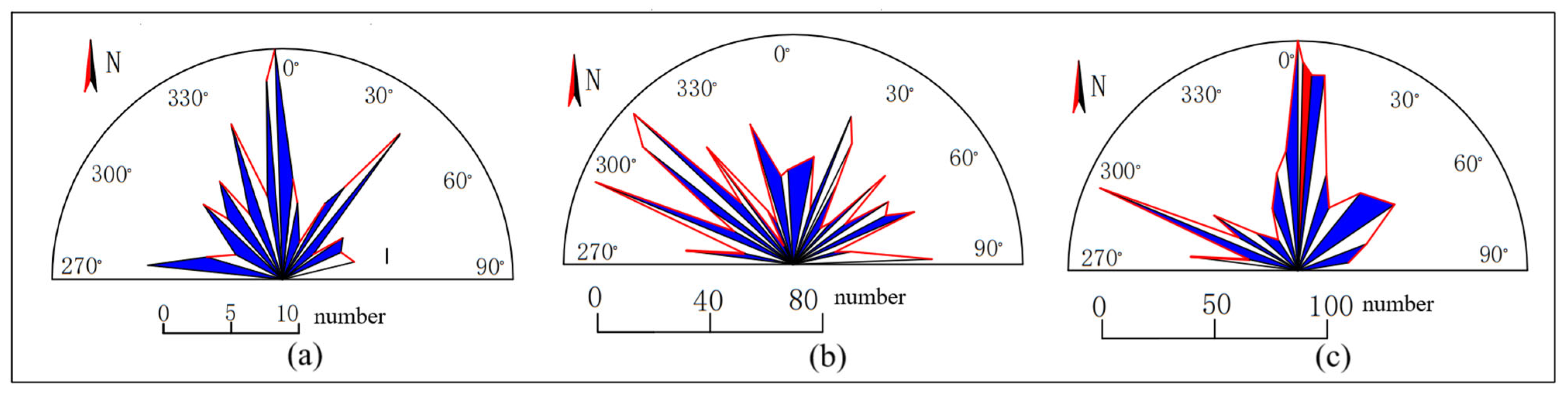
3.1. Development Characteristics of Surface Fissures

In this study, the dominant orientations of fracture development within the three sampling zones were identified and quantified using dynamic cluster analysis. A total of 3472 karstic fissures and gullies were measured and statistically analyzed; specifically, 248 were recorded in Sampling Zone 1, 1255 were recorded in Sampling Zone 2, and 1969 were recorded in Sampling Zone 3 (Table 1).
The survey data analysis reveals that the surface rock outcrops in the study area exhibit a relatively high development of fissures and gullies, predominantly formed by the expansion of shear joints through dissolution and erosion processes (Figure 3a). Most of these fissures display low-angle characteristics in their dip angles (Figure 3b), with the predominant range between 18° and 80° representing 65.44% of all observed fissures. Moreover, the line density of the dissolution gaps and grooves is recorded at 3.64 lines per meter. In the northwestern sector of the study area, the rock outcrops in Sampling Area 1 demonstrate a comparatively lower development of fissures and gullies, with a line density of 0.99 lines per meter. In stark contrast, the outcrops flanking the southern pond exhibit the most concentrated development of fissures and gullies, with a line density reaching 5.02 lines per meter (Figure 3c).
Regarding the impact of rock fissure filling on rainfall infiltration and transport, the sampling area reveals that 30% of the fissures and dissolution channels are filled with calcite veins, with the maximum width reaching 0.31 m. Additionally, 3% of the fractures are filled with mud or other materials, whereas unfilled fractures constitute 67% of the total surveyed fractures. The extensibility of the cracks and fissures in the study area is moderate, with a generally large aperture, ranging from 0.01 to 0.45 m, and an average width of 0.04 m. In the exposed rock layers, interlayer fractures are relatively scarce, while more developed interlayer fractures are observed (Figure 3d). The extension length of the cracks is generally extensive, with joints exceeding 1.5 m in length accounting for 77.46% of the total observed joints and through-going fractures exceeding 5 m in length representing 23.33%.
The results of the fracture orientation analysis in the sampling areas are depicted in Figure 4. In Sampling Zone 1, the dominant orientations of the ground rock layer fractures are north–south (NS) and north–northwest (NNW). In Sampling Zone 2, the preferred directions of fracture strikes are west–northwest (WNW), northwest (NW), and north–northeast (NNE). In Sampling Zone 3, the dominant fracture trends are west–northwest (WNW) and north–south (NS).

3.2. Anisotropy of Fractured Media

This study has advanced to analyze and determine the parameters of the fracture set permeability tensor within the research area, encompassing the principal permeability coefficients, the integrated permeability coefficients, and the principal directions of the anisotropic permeability tensor. The specific numerical values are presented in Table 2.
In Sampling Zone 1 and Sampling Zone 3, the principal axes of the maximum anisotropic permeability tensor of the fracture sets display northwest–southeast (NW–SE) and north–south (NS) orientations, respectively. Conversely, in Sampling Zone 2, this direction changes to a northeast–southwest (NE–SW) orientation. Nonetheless, initial hydrogeological investigations have identified multiple karstic depressions and cylindrical and fissured swallow holes in the northwest and north of Sampling Zone 1, as well as the east and northeast of Sampling Zone 3. These distinctive areas form the primary recharge zones of the groundwater system in the study area. The long axes of these depressions and swallow holes are primarily oriented in the north–south (NS) direction, with secondary directions in the northwest–southeast (NW–SE) orientation, aligning with the principal axes of the maximum permeability tensor of the exposed rock layer fracture sets.
The study area exhibits a range of integrated permeability coefficients between 0.55 and 16.10 m/d, with the maximum values of the permeability tensor ranging from 0.74 to 24.98 m/d. These values decrease sequentially from Sampling Zone 2 to Sampling Zone 3 and then to Sampling Zone 1, with the permeability coefficients in the discharge areas exceeding those in the recharge areas. The ratio of the maximum to minimum values of the permeability tensor falls between 2.67 and 6.75, indicating a pronounced anisotropy that reflects differences in permeability. Moreover, the integrated permeability tensor values in Sampling Zone 2 and Sampling Zone 3 are comparatively high, ranging from 5.72 to 16.10 m/d, and the dip angles of the principal axes of the maximum permeability tensors are relatively low. This suggests that the flow paths are longer, which, in turn, prolongs the residence time of karst water and intensifies its chemical dissolution effect on the underlying limestone.

3.3. Uneven and Zonal Development of Underground Karst

The results of the geophysical analysis conducted in this study have revealed the subsurface karst development at Zengpiyan exhibits uneven horizontal distribution and stratified vertical zoning characteristics (Figure 5).
Within the study area, 13 hydrogeological boreholes have exposed the presence of underground karst cavities. These cavities are predominantly developed between elevations of 120 m and 160 m, with vertical extents ranging from 0.3 to 10.5 m, and the borehole cave encounter rate is approximately 43.3%. All karst cavities revealed by the surface boreholes are situated within the Devonian Upper Series Rongxian Formation (D3r) limestone strata, while no cavities were identified within the underlying Guilin Formation (D3g) strata (Table 3). The boreholes that exposed the underground karst cavities are mainly distributed to the northeast of the P1–P2–P3 axis of the study area’s surface water bodies, with particularly significant cave encounter rates observed near the foot caves D1 and D2 at the base of Dushan Mountain.
Additionally, the study’s findings indicate that there is variable development of horizontal dissolution and fractures, with dips between 10° and 30°, vertically dipping dissolution and fractures with angles ranging from 70° to 90°, and oblique joints within the underground carbonate strata. Notably, the Rongxian Formation (D3r) limestone layer commonly exhibits well-developed dissolution and fractures, with a linear karst density of 21.2%. In boreholes ZK6, ZK7, ZK8, and ZK9, fractured limestone with a vertical distribution ranging from 0.2 to 1.3 m was encountered. Within the carbonate rocks of the Guilin Formation (D3g), except for the two boreholes, ZK14 and ZK16, that exposed numerous karst fractures, the overall karst development is relatively poor, with a linear karst density of 2.3%.
The cross-borehole electromagnetic wave tomography and CT scanning results have inferred and delineated a total of 233 water-bearing structures, including dissolution features, fractures, and karst caves, with heights varying from 18.0 to 86.0 m and widths ranging from 1.0 to 37.2 m. The most significant water-bearing structure is identified along the ZK12 to ZK22 profile. The tomographic profiling reveals three distinct karst development zones within the elevation range of 152 to 80 m: shallow, intermediate, and deep. Specifically, the interval between 152 m and 120 m marks a robust karst development zone, with the 155–145 m and 120–125 m intervals classified as strong karst development zones, the 145–135 m interval classified as a moderate karst development zone, and depths below 120 m classified as a weak karst development zone (Figure 6). Among these, the 155–145 m karst development zone is identified as the most intense underground karst development zone within the study area, exerting significant control over the pattern of karst groundwater enrichment.

4. Discussion

4.1. Development of Karst Surface Fissures and Analysis of Medium Anisotropy

Our analysis of the survey data has unveiled significant insights into the karst characteristics within the study area and their implications for rainfall infiltration and transport. The extensive development of fissures and grooves observed on the surface of rock outcrops is primarily attributed to the expansion of shear joints through dissolution and erosion, demonstrating the dynamic interplay between geological structures and rock dissolution processes [36,37,38]. The low-angle inclination of these dissolution gaps and channels indicates the main direction of water flow and dissolution, which is consistent with the formation conditions of fractures in the Jeta Karst system in Lebanon [39]. The inclination range of 18° to 80° accounts for 65.44% of the total observed fractures, underscoring the prominence of this feature within the study area. The linear density of karst fissures and gullies, at 3.64 per meter, further emphasizes the ubiquity of these karst features [40], which is pivotal for comprehending the hydrological behavior of the region. In Brazilian Neoproterozoic karst regions like Bambuí, Una, and Açungui, karstification typically enlarged bedding planes intersected by subvertical fractures [41]. This study reveals that the development of fractures and fissures in the northwest sampling area is relatively low, with a line density of 0.99 per meter. In contrast, the outcrops flanking the pond in the southern region exhibit a much denser development of fractures and fissures, with a line density of 5.02 per meter. The spatial variation in karst feature density suggests disparate rock dissolution rates across the study area, potentially influenced by factors such as lithology, tectonic history, and localized hydrological conditions [42]. Regarding the filling of rock fissures and dissolution channels, 30% are filled with calcite veins, reaching a maximum width of 0.31 m, 3% are filled with mud and other materials, and 67% remain unfilled, significantly impacting the infiltration process of rainfall [43]. The presence of fillers can act as a barrier to water flow, thereby altering the hydraulic properties of the rock mass [44,45]. Temperature has been proven to be one of the main media for the evolution of high-altitude karst fissures, such as in areas like British Columbia, Canada [46]. However, our research indicates that most fractures (67%) are unfilled, which may facilitate the rapid infiltration and recharge of the groundwater system. The moderate extensibility and large opening characteristics of the cracks and fissures are conducive to water flow [47,48]. Our study also found that the extension length of cracks is generally long, with joints exceeding 1.5 m accounting for 77.46% of the total observed joints and through-going cracks exceeding 5 m accounting for 23.33%. This indicates significant connectivity within the rock mass, which is vital for the transport of water and solutes in karst systems [49]. Furthermore, there is a notable difference in the dominant direction of fracture occurrence across different sampling areas, reflecting the complex interplay between structural geology and karst development.
In summary, this study provides a comprehensive understanding of karst characteristics and their impact on rainfall infiltration and transport. The spatial variation of karst characteristic density, the degree of filling of fractures, and the structural direction of fractures all contribute to the observed complex hydrological behavior [50]. These findings are crucial for developing groundwater flow models and managing water resources in karst landscapes. Further research is needed to elucidate the mechanisms behind the observed spatial changes and evaluate the long-term impact of these karst features on regional water cycling and geochemical processes.

4.2. Characteristics and Genesis Analysis of Underground Karst Development

The geophysical analysis conducted in this study has unveiled the subterranean karst development characteristics within the Zengpiyan area, highlighting the unevenness of its horizontal distribution and the stratification of its vertical zoning. This was corroborated by data obtained from 13 hydrogeological boreholes, which confirmed the presence of subsurface karst cavities predominantly within the limestone strata of the Rongxian Formation. In contrast, no cavities were detected within the strata of the Guilin Formation, suggesting a correlation between karstification processes and specific lithological horizons [51,52]. In contrast, in the northern karst region of the San Antonio Plateau, pure and fine carbonate rocks promote local underground karstification, which is closely related to water flow infiltration through cracks and bedding planes [53]. Geological and hydrochemical processes jointly promote the formation of karst landforms in the southeastern region of Riyadh in central Saudi Arabia [54]. The drilling data indicate that the karst caves are primarily developed between elevations of 120 m and 160 m, with considerable variation in their vertical extent. The encounter rate of these caves during drilling is approximately 43.3%, which underscores the spatial heterogeneity of karst development in the area.
This study further elucidates that the karst development within the limestone layer of the Upper Devonian Rongxian Formation in the Zengpiyan area is notably pronounced, primarily owing to the well-developed, thick-bedded, bright crystalline sandstone and the homogeneous calcite mineral composition [55]. These rock structures are inherently susceptible to fracturing, thereby generating secondary joint fissures that create conducive conditions for karstification [56]. The karst development conditions in Slovenia, Israel, and other areas around the Mediterranean are roughly the same [18,25,57]. The Rongxian Formation, which is positioned above the erosional datum, experiences frequent hydraulic activity and exhibits waters with a high concentration of dissolved carbon dioxide. The rock layers are readily subject to weathering and erosion, offering the requisite dissolution dynamics and spatial accommodation essential for karst development [58,59,60]. In contrast, the subjacent Guilin Formation exhibits subdued karst development within its carbonate rocks. The rock formation of the Guilin Formation comprises medium- to thick-bedded impure wormwood crystal limestone interlayered with dolomite. The mineral composition consists of calcite and dolomite, and it is situated below the saturated zone. The majority of the carbon dioxide transported by the water is consumed through chemical and biological processes in the aeration zone; hence, the groundwater potential is low, and hydrodynamic erosion is minimal [58]. Drilling activities in the Guilin Formation revealed an absence of faults, cleavage, or other discontinuities within the rock layers, which were found to be intact, culminating in underdeveloped karst features.
Furthermore, this study has discerned that the horizontal distribution of the underground karst system closely mirrors the pattern of surface fissures, suggesting that geological structures exert significant control on the lateral extent of karst development. The stratified characteristics of karst development markedly influence the concentration of groundwater aquifers [61]. Within the elevational band spanning from 152 to 80 m, the karst system manifests in three distinct strata: superficial, intermediate, and profound. Notably, the karst development zone within the interval of 155 to 145 m represents the most intensive subsurface karst development within the study area, exerting dominant control over the enrichment dynamics of karst groundwater resources.
In summary, this study reveals the controlling effects of geological structure, lithology, hydrodynamic conditions, and carbon dioxide concentration in water on karst development, providing an important scientific basis for understanding and predicting hydrogeological behavior in karst areas. Future research should further explore the interactions between these factors and their long-term effects on the formation and evolution of karst groundwater systems.

4.3. Limitations and Prospects

While this study has employed a comprehensive suite of methodologies, including geological drilling, geophysical data, field investigations, geostatistical analysis, permeability tensor calculations, and framework designs aligned with the research objectives, certain limitations are acknowledged. For instance, despite the dynamic clustering analysis of fissure development orientations aligning well with field observation data, the precision of these analyses may be constrained by the quality and spatial distribution of the data sampled. Furthermore, due to constraints in geological conditions and the spatiotemporal scale of this study, the evolution and patterns of karst water systems over extended periods are not fully captured. Consequently, future research should aim to address the current analysis’s deficiencies in spatial heterogeneity by incorporating multi-source, multi-temporal, and high-resolution geological and geophysical data. Concurrently, evaluating the long-term implications of potential climate change on the karst water system’s distribution within the context of future climate change model projections will be a significant research avenue. To fully utilize the potential of fully distributed integrated hydrological models, such as HGS, Wash123D, Parflow, or multi-physics platforms, such as COMSOL, exploring the number and types of additional measurements required will be an urgent problem to be solved in future research. Machine learning technology will deepen its application in the study of karst development characteristics, enhance the automation, quantification, and prediction capabilities of research, and bring innovative technologies to geology. Our dataset provides advantages for machine learning modeling. The advancement of data mining techniques, such as clustering analysis, classification, and outlier detection, will drive new advances in data processing and pattern recognition, reveal geological laws, and anticipate the construction of intelligent geological models to accurately predict karst development characteristics, enhancing scientific support for groundwater resource management and geological engineering decision-making. These acknowledged limitations and future research directions offer guidance for subsequent studies and assist the scientific community in gauging the applicability of the present findings and the imperative for continued investigation.

5. Conclusions

This study integrates geological drilling and geophysical data with field investigations, geostatistical analysis, and permeability tensor calculations to conduct a thorough analysis of surface rock fissures, subsurface karst voids, and their genesis within the typical peak forest plain karst water system of the Zengpiyan area in Guilin. The key findings are as follows:
(1) The surface fractures in the Zengpiyan area predominantly consist of low-angle planar fractures with a linear density of 3.64 per meter, which are predominantly distributed near ponds and Dushan Mountain. These fractures exhibit good extensibility and a generally moderate degree of filling, with apertures ranging from 0.01 to 0.45 m and an average spacing of 0.14 m. The primary development directions are NS, NE, and NW, offering vital clues for deciphering the karstification processes and groundwater flow paths in the region.
(2) The significant anisotropy observed in the surface fracture media, with the principal axis of the maximum permeability coefficient aligned with the orientations of karst depressions and sinkholes, suggests that karst landforms exert a substantial influence on the permeability of the fracture media. The comprehensive permeability coefficient varies from 0.55 to 16.10 m/d, and the maximum permeability tensor ranges from 0.74 to 24.98 m/d. The permeability in the discharge area is found to surpass that of the recharge area, which is a critical observation for anticipating hydrogeological behavior in karst terrains.
(3) Within the Zengpiyan Research Area, the karst development in the Rongxian Formation limestone layer is markedly pronounced, whereas the karstification of the Guilin Formation carbonate rocks is comparatively subdued. Horizontally, karst distribution along the P1–P2–P3 axis of surface water exhibits significant lateral variations, with more robust development on the eastern side compared to the western side. Vertically, two robust karst development zones are identified between 145–155 m and 120–130 m, a general development zone spans from 130–145 m, and a weak development zone exists below 130 m. These patterns reflect the influence of geological structure, rock type, hydrodynamics, and CO2 concentration on karst development.
(4) The horizontal distribution of the subsurface karst is congruent with the pattern of surface fissure development, indicating the predominant role of geological structures in governing the lateral extent of karst development. Concurrently, lithology, hydrodynamic conditions, and CO2 concentration in water emerge as pivotal factors in the formation of vertical zoning within the subsurface karst.

Author Contributions

Conceptualization, D.Y. and S.L.; methodology, G.J. and Y.W.; software, P.W. and J.Y.; validation, X.L. and G.L.; formal analysis, C.G. and F.Y.; investigation, H.W. and P.Y.; data curation, P.W. and G.J.; writing—original draft preparation, P.W. and J.Y.; writing—review and editing, G.J. and Y.W.; visualization, P.W. and J.Y.; supervision, D.Y.; project administration, G.J. and S.L.; funding acquisition, P.W. and Y.W. All authors have read and agreed to the published version of the manuscript.

Funding

This research was funded by the Guizhou Provincial Key Project of Philosophy and Social Science Planning (24GZZD17); Projects of Karst Dynamics Laboratory, MNR and GZAR (KDL&Guangxi202103); Guizhou Provincial Science and Technology Projects (QKHJC-ZK [2022] YB334); Guizhou Provincial Science and Technology Projects (QKHZC [2023] YB228); Guizhou Provincial Science and Technology Projects (QKZYD [2022] 4031); the Guizhou Provincial Digital Rural Innovation Team in Higher Education (QJJ [2023] 076); and the Guizhou Provincial Engineering Research Center in Higher Education [QJJ (2023) 039].

Data Availability Statement

The dataset is available upon request from the authors.

Acknowledgments

We thank the anonymous reviewers for their valuable comments. We appreciate Runze Wu, Huancai Feng, Lei Gu, and Shasha Li’s suggestions for paper revision. We gratefully acknowledge the design of D.Y. and the contributions of the co-authors.

Conflicts of Interest

The authors declare no conflicts of interest.

References

  1. Hartmann, A.; Goldscheider, N.; Wagener, T.; Lange, J.; Weiler, M. Karst Water Resources in a Changing World: Review of Hydrological Modeling Approaches. Rev. Geophys. 2014, 52, 218–242. [Google Scholar] [CrossRef]
  2. Chen, Z.; Auler, A.S.; Bakalowicz, M.; Drew, D.; Griger, F.; Hartmann, J.; Jiang, G.; Moosdorf, N.; Richts, A.; Stevanovic, Z.; et al. The World Karst Aquifer Mapping Project: Concept, Mapping Procedure and Map of Europe. Hydrogeol. J. 2017, 25, 771–785. [Google Scholar] [CrossRef]
  3. White, W.B. Karst Hydrology: Recent Developments and Open Questions. Eng. Geol. 2002, 65, 85–105. [Google Scholar] [CrossRef]
  4. Tang, Y.; Zhang, Q.; Qi, J.; Xu, M.; Li, X.; Qu, C.; Yi, L.; Wang, D. Change Analysis of Karst Landforms, Hydrogeological Conditions and Effects of Tunnel Excavation on Groundwater Environment in Three Topography Grades in China. Water 2023, 15, 207. [Google Scholar] [CrossRef]
  5. Hu, Z.; Wang, S.; Bai, X.; Luo, G.; Li, Q.; Wu, L.; Yang, Y.; Tian, S.; Li, C.; Deng, Y. Changes in Ecosystem Service Values in Karst Areas of China. Agric. Ecosyst. Environ. 2020, 301, 107026. [Google Scholar] [CrossRef]
  6. Liu, L. Assessment of Water Resource Security in Karst Area of Guizhou Province, China. Sci. Rep. 2021, 11, 7641. [Google Scholar] [CrossRef]
  7. Li, S.-L.; Liu, C.-Q.; Chen, J.-A.; Wang, S.-J. Karst Ecosystem and Environment: Characteristics, Evolution Processes, and Sustainable Development. Agric. Ecosyst. Environ. 2021, 306, 107173. [Google Scholar] [CrossRef]
  8. Ravbar, N.; Goldscheider, N. Comparative Application of Four Methods of Groundwater Vulnerability Mapping in a Slovene Karst Catchment. Hydrogeol. J. 2009, 17, 725–733. [Google Scholar] [CrossRef]
  9. Petrič, M.; Ravbar, N.; Gostinčar, P.; Krsnik, P.; Gacin, M. GIS Database of Groundwater Flow Characteristics in Carbonate Aquifers: Tracer Test Inventory from Slovenian Karst. Appl. Geogr. 2020, 118, 102191. [Google Scholar] [CrossRef]
  10. Zhang, R.; Shu, L.; Zhu, J.; Yu, Z.; Jiang, P. Storage and Drainage Characteristics of a Highly Heterogeneous Karst Aquifer in Houzhai Basin. Ground Water 2016, 54, 878–887. [Google Scholar] [CrossRef]
  11. Frumkin, A.; Barzilai, O.; Hershkovitz, I.; Ullman, M.; Marder, O. Karst Terrain in the Western Upper Galilee, Israel: Speleogenesis, Hydrogeology and Human Preference of Manot Cave. J. Hum. Evol. 2021, 160, 102618. [Google Scholar] [CrossRef] [PubMed]
  12. Frumkin, A.; Langford, B.; Lisker, S. Hypogenic Karst at the Arabian Platform Margins: Implications for Far-Field Groundwater Systems. KIP Artic. 2017, 129, 11–12. [Google Scholar] [CrossRef]
  13. Abotalib, A.Z.; Sultan, M.; Elkadiri, R. Groundwater Processes in Saharan Africa: Implications for Landscape Evolution in Arid Environments. Earth-Sci. Rev. 2016, 156, 108–136. [Google Scholar] [CrossRef]
  14. Zheng, J.; Wang, X.; Lü, Q.; Sun, H.; Guo, J. A New Determination Method for the Permeability Tensor of Fractured Rock Masses. J. Hydrol. 2020, 585, 124811. [Google Scholar] [CrossRef]
  15. Wang, X.; Zheng, J.; Sun, H.; Lü, Q.; Ge, Q.; Tan, S. A Semi-Theoretical Method for Determining the Permeability Tensor of Fractured Rock Masses in Three-Dimensional Space. Phys. Fluids 2024, 36, 026613. [Google Scholar] [CrossRef]
  16. Cardoso de Salis, H.H.; Monteiro da Costa, A.; Moreira Vianna, J.H.; Azeneth Schuler, M.; Künne, A.; Sanches Fernandes, L.F.; Leal Pacheco, F.A. Hydrologic Modeling for Sustainable Water Resources Management in Urbanized Karst Areas. Int. J. Environ. Res. Public Health 2019, 16, 2542. [Google Scholar] [CrossRef] [PubMed]
  17. Wang, Z.; Zhou, H.; Qi, L.; Wang, J.; Yan, Z. Method for Characterizing Structure and Hydrological Response in Karst Water Systems: A Case Study in Y-M System in Three Gorges Area. Earth Sci. 2020, 45, 4512–4523. [Google Scholar] [CrossRef]
  18. Bresinsky, L.; Kordilla, J.; Engelhardt, I.; Livshitz, Y.; Sauter, M. Variably Saturated Dual-Permeability Flow Modeling to Assess Distributed Infiltration and Vadose Storage Dynamics of a Karst Aquifer—The Western Mountain Aquifer in Israel and the West Bank. J. Hydrol. X 2023, 18, 100143. [Google Scholar] [CrossRef]
  19. Wu, Y.Y.; Liu, L.B.; Guo, C.Z.; Zhang, Z.H.; Hu, G.; Ni, J. Low carbon storage of woody debris in a karst forest in southwestern China. Acta Geochim. 2019, 38, 576–586. [Google Scholar] [CrossRef]
  20. Ni, J.; Luo, D.H.; Xia, J.; Zhang, Z.H.; Hu, G. Vegetation in Karst Terrain of Southwestern China Allocates More Biomass to Roots. Solid Earth Discuss. 2015, 7, 1209–1235. [Google Scholar] [CrossRef]
  21. Ma, Z.; Yang, H. The development and utilization technology of water resources in karst areas abroad and its enlightenment to China. J. Guangxi Acad. Sci. 2022, 38, 352–363. [Google Scholar] [CrossRef]
  22. Yan, H.M.; Chang, W.; Guo, X.L.; Deng, Z.R.; Huang, K. Identification of the karst water flow system and its application in the tunnel line selection of water diversion projects. Bull. Geol. Sci. Technol. 2022, 41, 127–136. [Google Scholar] [CrossRef]
  23. Wang, F.; Zhang, J.; Lian, J.; Fu, Z.; Luo, Z.; Nie, Y.; Chen, H. Spatial Variability of Epikarst Thickness and Its Controlling Factors in a Dolomite Catchment. Geoderma 2022, 428, 116213. [Google Scholar] [CrossRef]
  24. Zhang, J.; Fu, Z.; Nie, Y.; Lian, J.; Luo, Z.; Wang, F.; Chen, H. Microclimate Stability on the Critical Zone of a Karst Hillslope in Southwest China: Insights from Continuous Temperature Observations at the Air–Soil–Epikarst Interface. J. Environ. Manag. 2023, 336, 117656. [Google Scholar] [CrossRef]
  25. Olarinoye, T.; Gleeson, T.; Marx, V.; Seeger, S.; Adinehvand, R.; Allocca, V.; Andreo, B.; Apaéstegui, J.; Apolit, C.; Arfib, B.; et al. Global Karst Springs Hydrograph Dataset for Research and Management of the World’s Fastest-Flowing Groundwater. Sci. Data 2020, 7, 59. [Google Scholar] [CrossRef]
  26. Benteng, B.I.; Lixin, Z.; Chen, Y.; Yaqiong, Y.; Wenqiang, S.H.I. Karst Landforms and Development Vitality in Southwest China. CHINA Min. Mag. 2022, 31 (Suppl. S1), 217–220. [Google Scholar] [CrossRef]
  27. Shi, P.; Tang, H.; Qu, S.; Zhao, L.; Li, Q. Drought Propagation in Karst and Non-Karst Regions in Southwest China Compared on a Daily Scale. J. Hydrol. Reg. Stud. 2024, 51, 101628. [Google Scholar] [CrossRef]
  28. Pan, S.; He, Z.; Gu, X.; Xu, M.; Chen, L.; Yang, S.; Tan, H. Agricultural Drought-Driven Mechanism of Coupled Climate and Human Activities in the Karst Basin of Southern China. Sci. Rep. 2024, 14, 12072. [Google Scholar] [CrossRef] [PubMed]
  29. Wang, S.-J.; Liu, Q.-M.; Zhang, D.-F. Karst Rocky Desertification in Southwestern China: Geomorphology, Landuse, Impact and Rehabilitation. Land Degrad. Dev. 2004, 15, 115–121. [Google Scholar] [CrossRef]
  30. Ghezelayagh, P.; Javadi, S.; Kavousi, A. COP*KAT: A Modified COP Vulnerability Mapping Method for Karst Terrains Using KARSTLOP Factors and Fuzzy Logic. Environ. Earth Sci. 2021, 80, 592. [Google Scholar] [CrossRef]
  31. Pietruszczak, S.; Jameei, A.A. Assessment of Stress-Induced Evolution of Permeability Tensor in Rock Mass Containing Discrete Fracture Network. Comput. Geotech. 2024, 174, 106580. [Google Scholar] [CrossRef]
  32. Luo, M.; Chen, Z.; Zhou, H.; Jakada, H.; Zhang, L.; Han, Z.; Shi, T. Identifying Structure and Function of Karst Aquifer System Using Multiple Field Methods in Karst Trough Valley Area, South China. Environ. Earth Sci. 2016, 75, 824. [Google Scholar] [CrossRef]
  33. Ding, C.; Xue, K.; Zhu, X.; Zhou, C.; Chen, J.; Han, K.; Luo, Q.; Yi, G. Application of the Opposing-Coils Transient Electromagnetic Method Combined with Ground-Penetrating Radar for the Identification of Shallow Geohazards: A Case Study in Xiacun Town, Xinyu City, China. Hydrogeol. J. 2024, 32, 1925–1943. [Google Scholar] [CrossRef]
  34. Huang, S.; Lin, J.; Huang, Q.; Liang, R. An Emerging Method Using Electromagnetic Wave Computed Tomography for the Detection of Karst Caves. Geotech. Geol. Eng. 2020, 38, 2713–2723. [Google Scholar] [CrossRef]
  35. Souza de Araújo, O.; Chemas Hindi, E.; Rigoti, A.; Rigoti, F.H. Improved Imaging of a Karst Aquifer Using Focused Source Electromagnetic and Differentially Normalized Method: A Qualitative Analysis. Geophys. Prospect. 2019, 67, 1965–1976. [Google Scholar] [CrossRef]
  36. Zhao, X.; Chang, Y.; Wu, J.; Peng, F. Laboratory Investigation and Simulation of Breakthrough Curves in Karst Conduits with Pools. Hydrogeol. J. 2017, 25, 2235–2250. [Google Scholar] [CrossRef]
  37. Ding, H.; Zhang, X.; Chu, X.; Wu, Q. Simulation of Groundwater Dynamic Response to Hydrological Factors in Karst Aquifer System. J. Hydrol. 2020, 587, 124995. [Google Scholar] [CrossRef]
  38. Mohammadi, Z.; Raeisi, E.; Zare, M. A Dye-Tracing Test as an Aid to Studying Karst Development at an Artesian Limestone Sub-Aquifer: Zagros Zone, Iran. Environ. Geol. 2007, 52, 587–594. [Google Scholar] [CrossRef]
  39. Doummar, J.; Margane, A.; Geyer, T.; Sauter, M. Assessment of Key Transport Parameters in a Karst System under Different Dynamic Conditions Based on Tracer Experiments: The Jeita Karst System, Lebanon. Hydrogeol. J. 2018, 26, 2283–2295. [Google Scholar] [CrossRef]
  40. Roded, R.; Aharonov, E.; Frumkin, A.; Weber, N.; Lazar, B.; Szymczak, P. Cooling of Hydrothermal Fluids Rich in Carbon Dioxide Can Create Large Karst Cave Systems in Carbonate Rocks. Commun. Earth Environ. 2023, 4, 465. [Google Scholar] [CrossRef]
  41. Assunção, P.; Galvão, P.; Lucon, T.; Doi, B.; Marshall Fleming, P.; Marques, T.; Costa, F. Hydrodynamic and Hydrodispersive Behavior of a Highly Karstified Neoproterozoic Hydrosystem Indicated by Tracer Tests and Modeling Approach. J. Hydrol. 2023, 619, 129300. [Google Scholar] [CrossRef]
  42. Jiu, B.; Huang, W.; Mu, N.; He, M. Effect of Hydrothermal Fluids on the Ultra-Deep Ordovician Carbonate Rocks in Tarim Basin, China. J. Pet. Sci. Eng. 2020, 194, 107445. [Google Scholar] [CrossRef]
  43. Xu, X.; Yan, Y.; Dai, Q.; Yi, X.; Hu, Z.; Cen, L. Spatial and Temporal Dynamics of Rainfall Erosivity in the Karst Region of Southwest China: Interannual and Seasonal Changes. CATENA 2023, 221, 106763. [Google Scholar] [CrossRef]
  44. Li, X.; Wang, Y.; Shu, L.; Wang, Y.; Tong, F.; Han, J.; Shu, W.; Li, D.; Wen, J. The Controlling Factors of the Karst Water Hydrochemistry in a Karst Basin of Southwestern China. Environ. Earth Sci. 2021, 80, 793. [Google Scholar] [CrossRef]
  45. Rabelo, J.G.; Maia, R.P.; Bezerra, F.H.R.; Silva, C.C.N. Karstification and Fluid Flow in Carbonate Units Controlled by Propagation and Linkage of Mesoscale Fractures, Jandaíra Formation, Brazil. Geomorphology 2020, 357, 107090. [Google Scholar] [CrossRef]
  46. Langston, G.; Hayashi, M.; Roy, J.W. Quantifying Groundwater-Surface Water Interactions in a Proglacial Moraine Using Heat and Solute Tracers. Water Resour. Res. 2013, 49, 5411–5426. [Google Scholar] [CrossRef]
  47. Quan, L.; Wang, G.; Zhang, Y.; Hao, F.; Xu, R.; Zhou, L.; Liu, Z. Early Dolomitization and Subsequent Hydrothermal Modification of the Middle Permian Qixia Formation Carbonate in the Northwest Sichuan Basin. Geoenergy Sci. Eng. 2023, 221, 211384. [Google Scholar] [CrossRef]
  48. La Bruna, V.; Bezerra, F.H.R.; Souza, V.H.P.; Maia, R.P.; Auler, A.S.; Araujo, R.E.B.; Cazarin, C.L.; Rodrigues, M.A.F.; Vieira, L.C.; Sousa, M.O.L. High-Permeability Zones in Folded and Faulted Silicified Carbonate Rocks—Implications for Karstified Carbonate Reservoirs. Mar. Pet. Geol. 2021, 128, 105046. [Google Scholar] [CrossRef]
  49. Guo, T.; Lv, M.; Luo, P.; Yang, X.; Chen, M.; Weng, D.; Qu, Z.; Liu, Y. Assessment and Optimization of Fracture-Karst Cave Connectivity in Horizontal Well Hydraulic Fracturing of Carbonate Reservoirs. Rock Mech. Bull. 2024, 3, 100112. [Google Scholar] [CrossRef]
  50. Hou, L.; Su, Z.; Wei, L.; Wei, X.; Zhang, C.; Fu, S.; Han, Y.; Ren, J.; Chen, H. Residual Carbonate Karst Reservoir Reconstructed by Karst Planation: A Case Study of Ordovician Paleokarst Reservoir Characterization in Ordos Basin, North China. Geoenergy Sci. Eng. 2024, 233, 212508. [Google Scholar] [CrossRef]
  51. Liu, P.; Yao, J.; Couples, G.D.; Ma, J.; Iliev, O. 3-D Modelling and Experimental Comparison of Reactive Flow in Carbonates under Radial Flow Conditions. Sci. Rep. 2017, 7, 17711. [Google Scholar] [CrossRef] [PubMed]
  52. Dong, W.; Li, Z.; Shen, L.; Liu, W.; Guo, Y.; Xu, H.; Yong, R. Study on the Process of Mass Transfer and Deterioration of Limestone under Dynamic Dissolution of CO2 Solution. Sci. Rep. 2024, 14, 5278. [Google Scholar] [CrossRef] [PubMed]
  53. Reis, L.; Dimuccio, L.A.; Cunha, L. Assessing Endokarst Potential in the Northern Sector of Santo António Plateau (Estremadura Limestone Massif, Central Portugal). Sustainability 2023, 15, 15599. [Google Scholar] [CrossRef]
  54. Al-Hashim, M.H.; Al-Aidaros, A.; Zaidi, F.K. Geological and Hydrochemical Processes Driving Karst Development in Southeastern Riyadh, Central Saudi Arabia. Water 2024, 16, 1937. [Google Scholar] [CrossRef]
  55. Mount, J.F. Mixing of Siliciclastic and Carbonate Sediments in Shallow Shelf Environments. Geology 1984, 12, 432–435. [Google Scholar] [CrossRef]
  56. Reik, G.A.; Currie, J.B. A Study of Relations between Rock Fabric and Joints in Sandstone. Can. J. Earth Sci. 1974, 11, 1253–1268. [Google Scholar] [CrossRef]
  57. Abusaada, M.; Sauter, M. Studying the Flow Dynamics of a Karst Aquifer System with an Equivalent Porous Medium Model. Groundwater 2013, 51, 641–650. [Google Scholar] [CrossRef]
  58. Shang, J.; Feng, M.; Wang, X.; Zhang, B.; Xu, L.; Liu, X. Alteration Effects of Karstification and Hydrothermalism on Middle Permian Qixia Formation at the Wulong Section, South China. Sci. Rep. 2023, 13, 13128. [Google Scholar] [CrossRef]
  59. Feng, M.; Shang, J.; Shen, A.; Wen, L.; Wang, X.; Xu, L.; Liang, F.; Liu, X. Episodic Hydrothermal Alteration on Middle Permian Carbonate Reservoirs and Its Geological Significance in Southwestern Sichuan Basin, SW China. Pet. Explor. Dev. 2024, 51, 81–96. [Google Scholar] [CrossRef]
  60. Zhang, H.; Xu, G.; Liu, M.; Wang, M. Formation Environments and Mechanisms of Multistage Paleokarst of Ordovician Carbonates in Southern North China Basin. Sci. Rep. 2021, 11, 819. [Google Scholar] [CrossRef]
  61. Luo, L.; Liang, X.; Luo, M.; Zhou, H. Characterizing the Hierarchical Groundwater Flow Systems in Karstic Xiangxi River Basin, West Hubei, Central China. Appl. Geochem. 2022, 143, 105371. [Google Scholar] [CrossRef]
Figure 1. Geographical location (a) and geological structural characteristics (b) of the research area (according to the Institute of Karst Geology, Chinese Academy of Geological Sciences, 1988). 1. Fracture (nature unknown); 2. Speculative fracture; 3. Detrital rock; 4. Limestone 5. Stratigraphic code and boundary; 6. Anticline; 7. Synclinal; 8. Location of Zengpiyan Site.
Water 16 03486 g001
Figure 2. Location map of the fissure investigation sampling area in the study area.
Water 16 03486 g002
Figure 3. Field survey indicators of fractures and grikes within the study area. (a) Shear fractures cutting through stratigraphic layers; (b) Low- and high-angle fractures; (c) Grikes; (d) Interlayer cracks. The red line represents the direction of fractures and grikes.
Water 16 03486 g003aWater 16 03486 g003b
Figure 4. Rose diagram of crack distribution in sampling area. (a) The direction of cracks in sampling zone 1. (b) The direction of cracks in sampling zone 2. (c) The direction of cracks in sampling zone 3.
Water 16 03486 g004
Figure 5. Partial borehole bar chart.
Water 16 03486 g005
Figure 6. Horizontal distribution and vertical zoning of underground karst development in Zengpiyan.
Water 16 03486 g006
Table 1. Investigation parameters for rock outcrop trenches and fissures in the study area.
ParametersFissuresStratumAdvantageous Occurrence
dip∠Dipangle/(°)
Fracture Rate of Linear
(/m)
Rock Fracture Width
/(m)
Sampling Area
1248D3r143∠760.990.001~0.12
21255D3r162∠605.020.001~0.23
31969D3r114∠644.920.001~0.45
Total3472D3r125∠623.640.001~0.45
Table 2. Permeability tensor of the study area.
Fissure GroupRecharge AreaDischarge Area
Sampling Zone 1Sampling Zone 3Sampling Zone 2
i = 1i = 2i = 3i = 4i = 5i = 6
K1Value (m/d)0.440.782.756.697.379.22
Strike α (°)167.142.553.5221.7060.8123.50
Dip angle β (°)56.2164.6171.7743.1974.0932.54
K2value (m/d)0.511.237.759.0013.4618.89
Strike α (°)67.1771.45165.45123.30134.11150.90
Dip angle β (°)18.4237.2242.3310.6231.2161.06
K3value (m/d)0.743.3716.2816.1821.0423.98
Strike α (°)1.35135.208.78112.32155.12143.25
Dip angle β (°)60.0426.6747.7521.4419.6665.33
K ¯ value (m/d)0.551.485.727.0112.7816.10
Table 3. Development of underground karst caves exposed by drilling.
Borehole Elevation/(m)Layer NumberCave Elevation/(m)Altitude/(m)Stratigraphic
ZK1155.5 150.3~149.21.1D3r
ZK2162.5 158.7~157.41.3D3r
ZK3154.91152.0~151.20.8D3r
2150.6~150.30.3D3r
ZK6155.3 148.0~147.30.7D3r
ZK7153.9 125.6~124.21.4D3r
ZK9155.4 114.5~113.90.6D3r
ZK10153.3 128.2~117.710.5D3r
ZK11153.5 143.2~142.80.4D3r
ZK14157.6 145.3~143.22.1D3r
ZK16164.51142.0~141.20.8D3r
2135.0~124.510.5D3r
ZK19152.8 145.8~137.08.8D3r
YK1155.7 154.5~153.01.5D3r
YK3155.3 154.1~152.81.3D3r
Disclaimer/Publisher’s Note: The statements, opinions and data contained in all publications are solely those of the individual author(s) and contributor(s) and not of MDPI and/or the editor(s). MDPI and/or the editor(s) disclaim responsibility for any injury to people or property resulting from any ideas, methods, instructions or products referred to in the content.

