Article

Water Resources Management for Multi-Source Ecological Restoration Goals in an Oasis: A Case Study of Bohu County Irrigation Area in Xinjiang, China

1
State Key Laboratory of Desert and Oasis Ecology, Xinjiang Institute of Ecology and Geography, Chinese Academy of Sciences, Urumqi 830011, China
2
Key Laboratory of GIS & RS Application Xinjiang Uygur Autonomous Region, Urumqi 830011, China
3
University of Chinese Academy of Sciences, Beijing 100049, China
4
College of Hydraulic Conservancy and Civil Engineering, Xinjiang Agricultural University, Urumqi 830052, China
5
CAS Research Center for Ecology and Environment of Central Asia, Urumqi 830011, China
*
Author to whom correspondence should be addressed.
Water 2024, 16(19), 2708; https://doi.org/10.3390/w16192708
Submission received: 17 August 2024 / Revised: 17 September 2024 / Accepted: 20 September 2024 / Published: 24 September 2024
(This article belongs to the Section Ecohydrology)

Abstract

:
Oases in arid regions consist of river–lake–groundwater systems characterized by complex hydrological cycles and fragile ecosystems. Sustainable water resource management, aimed at multi-source ecological restoration, is crucial for oasis ecological protection and represents a current research challenge. This study focuses on the Bohu irrigation area, using ecological water levels, the MIKE-SHE hydrological model, and the water balance equation to propose a multi-objective groundwater and surface water regulation scheme that meets both the ecological safety requirements of the irrigation area and the ecological water demands of the Small Lake. Key findings include the following: (1) The regional ecological water level ranges from 1.69 m to 4 m, with about 74% of the area exceeding this range, threatening local ecology. (2) The proposed regulation method adjusts 91.25% of areas exceeding the ecological water level to within the acceptable range. (3) Under various planting scenarios, the minimum water distribution from the west branch of the BLSM water diversion hub should be 824.632 ×   10 6   m 3 / a to meet Small Lake ecological demands. When this volume exceeds 831.902 ×   10 6   m 3 / a , both groundwater regulation and Small Lake ecological demands are satisfied. This paper quantifies the water cycle mechanisms in complex hydrological interaction areas, providing specific solutions to regional ecological problems, which holds significant practical relevance.

1. Introduction

Oases are distinctive natural and cultural landscapes found in arid regions, which are shaped by factors such as geographical location, topography, and climate [1,2]. Limited water resources are a necessary condition for the survival and development of oases, as well as a major reason for oases to become the main locations for biological growth and agricultural production in arid areas [3]. One of the key aspects of protecting oasis security is to achieve sustainable utilization of water resources. However, oasis ecosystems are often very fragile [4], which means that in oasis water resources management in inland river basin irrigation areas, more aspects need to be considered than in general regional water resources management.
The Bohu irrigation area is situated in the midstream region of the Tarim River. The entire area consists of an oasis river–lake–groundwater system, with complex hydrological interactions and a fragile ecosystem. Since 1998, the continuous expansion of agricultural land [5] in the area has led to two main ecological problems. (1) Due to the inadequate water supply from the Karaxahar River to meet the needs of the rapidly increasing agricultural land in the district, the irrigation area has heavily relied on groundwater extraction while developing water-saving technologies such as impermeable channels and drip irrigation. The annually increasing groundwater extraction has led to overexploitation of the regional aquifers, disrupting the original groundwater balance. This has resulted in severe ecological issues such as the degradation of surface vegetation and the deterioration of shallow groundwater quality [6,7,8]. (2) In the small lakes area of Bosten Lake (referred to as “Small Lake”) in the lower reaches of the Karaxahar River, reeds are widely distributed [9] and have a large biomass [10]. However, due to the continuous expansion of oasis farmland area and the instability of upstream water, the wetland water level fluctuates violently, and the ecological water demand of the wetland cannot be guaranteed [11], resulting in a reduction in wetland vegetation biomass and seriously threatening the safety of wetland functions. However, current research in this area mainly focuses on a single water cycle factor (groundwater, Karaxahar River, Bosten Lake) and most works focus on the study of water chemistry [12,13,14,15]. The current understanding of the hydrological interactions among rivers, lakes, and groundwater, as well as regional studies on sustainable water resource utilization, is incomplete. To preserve the ecological integrity of the entire interactive area and ensure sustainable water resource utilization that meets the needs of daily production and livelihoods, the scientifically regulated management of regional water resources is urgently required.
Therefore, based on the actual situation of the Bohu irrigation area, this paper sets two regulatory objectives: (1) to adjust the combined irrigation method of groundwater and surface water to maintain the groundwater level within a reasonable ecological safety range; (2) to regulate the total water transfer volume in the region to ensure that the total water volume meets the irrigation area’s crop growth needs and the ecological water volume of the Small Lake vegetation. However, due to the direct or indirect impact of agricultural activities in the irrigation area on the regional water resources cycle, there are significant differences in the temporal and spatial distribution of water resources [16]. Groundwater in the irrigation area exhibits strong spatiotemporal heterogeneity [17,18,19], making it difficult to analyze the entire region as a unified whole. Therefore, the key scientific problem that this paper needs to address is how to achieve and quantify the joint sustainable regulation of groundwater and surface water in areas with high spatiotemporal heterogeneity of water resource distribution to meet multiple regulation objectives.
The key to solving these problems lies in understanding the regional water cycle mechanisms, with the numerical simulation of groundwater being a central approach. Compared to other methods, numerical simulation can better reflect the hydrological cycle and interactive mechanisms of a region, facilitating researchers’ understanding of regional hydrological processes [16,20]. The MIKE-SHE hydrological model, known for its excellent performance in simulating river–saturated zone interactions and groundwater extraction in saturated areas, is particularly suitable for this study. Our research team has previously developed a high-precision MIKE-SHE hydrological model for this region and identified the relationship between regional groundwater extraction and groundwater depth in our published paper [21]. These findings provide a theoretical basis for formulating rational groundwater extraction policies and lay the groundwork for exploring regional water cycle mechanisms and simulating water resource management strategies.
The goal of comprehensive water resource regulation is to establish reasonable ecological indicators that align with the characteristics of arid region irrigation areas. For the first ecological issue, this paper introduces the notion of the ecological water level, which pertains to a justifiable range of fluctuations in groundwater levels wherein no harm is inflicted upon the ecological environment [22]. The definitions of intervals vary in different regions. For arid areas, the root depth of surface vegetation and soil properties are the most important factors affecting shallow groundwater [23]. Hence, in arid regions, the upper boundary of the ecological water level range is commonly defined as the water level that leads to intense groundwater evaporation and surface salt accumulation, ultimately resulting in salinization [24]. The lower boundary is the water level at which vegetation roots cannot contact the aquifer, causing plants to degrade due to lack of water, thus causing land desertification [25]. In over-exploited irrigation areas, especially in the transition zone of irrigation areas, low groundwater levels pose a serious threat to ecology. In this paper, the capillary tube method is utilized to compute the upper and lower boundaries of ecological water levels, leading to the determination of the target threshold for regional groundwater regulation. Concerning the second ecological concern, numerous studies have addressed the ecological water demand in small lake areas [11,26,27]. However, these studies vary in their objectives and consequently yield different calculations for the ecological water demand in small lakes. Based on the synthesis of the literature, Peng’s calculated water demand for a small lake was chosen as the target for small lake water resource regulation because its temporal and spatial resolution matches well with the outputs from our hydrological model, and its research objectives align with those of this paper.
In summary, this paper is divided into three main research areas: (1) using the capillary method to calculate regional ecological water levels, defining the reasonable range of groundwater levels in the irrigation district, and diagnosing the spatiotemporal distribution of groundwater in the district; (2) formulating a regulation scheme based on the relationship between single well extraction and groundwater (as established in previous research) and simulating the regulation results using the MIKE-SHE hydrological model; (3) exploring the regional water cycle mechanism through scenario analysis, combining the water balance equation and the ecological water demand of a small lake (as determined in previous research), and quantifying a water resource allocation plan that meets both the ecological water level requirements of the irrigation district and the ecological water demand of a small lake. This study explores the hydrological issues underlying complex ecological problems in water-interactive regions and serves as a further development and summary of previous research. The results of this paper achieve multi-objective water resources management in regions with complex hydrological interactions and can provide valuable experience for water resource management in other arid irrigation areas.

2. Materials and Methods

2.1. Study Area

The Bohu irrigation area is situated in the Yanqi Basin, which is a Mesozoic rift basin nestled between the Tianshan Mountains and the subsidiary branches of the river [28]. A broad soil plain is formed in the middle part of the basin and the gravel belt in the piedmont. Affected by the flood sedimentation phenomenon [29], the basin has widely distributed alluvium and sedimentary layers of lake and swamp. The region experiences a pronounced continental monsoon climate, marked by elevated temperatures, substantial evapotranspiration rates, and limited rainfall. The annual precipitation is concentrated from May to September, amounting to only 73.3 mm, while the average annual evaporation is about 1344.4 mm [30].
Model simulation is the basis of our research. In order to increase the accuracy of the model simulation and reduce the uncertainty of the output results [31], and subject to the requirements of model boundary conditions [32] and research purposes, the Bohu irrigation area is further divided into hydrological interaction areas (study area) as shown in Figure 1. The cultivation of land in this region encompasses approximately 70% of the total area, with a total irrigated area spanning 3568 square kilometers. The hydrological interaction process studied in this article mainly includes the recharge of groundwater by the infiltration of irrigation water, the hydraulic exchange between the surface runoff of the Karaxahar River and the Small Lake, and the hydraulic exchange of the groundwater between the irrigation area and the Small Lake.
In terms of surface water, the dominant river is the Karaxahar River in the study area, located in the upper reaches of Bosten Lake. Originating from the Tianshan Mountains, this river heavily relies on the crucial supply of melting snow from the mountain range [33]. Its water network develops in one direction along the terrain and finally flows into Bosten Lake. The water inflow is primarily influenced by the climate, with concentrations occurring between March and October. There is an average annual runoff increase of 0.0285 (m3/s)/10 a . There is one hydrological station Bao Lang Su Mu (BSLM) and three groundwater observation points (L46, L47, L48) in the study area. Among them, the BSLM water diversion hub bifurcates the Karaxahar River into its east and west branches. The eastward branch feeds into Boste n Lake, whereas the westward branch supplies the southern Small Lake. The average annual runoff at the BSLM water diversion hub reaches 2.514 billion cubic meters. The Karaxahar River serves as the sole surface water source for the Small Lake and is intrinsically linked to its water volume. After traversing the Small Lake, the Karaxahar River ultimately discharges into the downstream Kongque River.
In terms of phreatic geology, groundwater primarily originates from aquifers composed of Quaternary unconsolidated sediments found in sedimentary layers. In the extensive alluvial delta downstream of the Karaxahar River, the Holocene alluvial layer typically ranges in thickness from 30 to 50 m. In the northwest to southeast direction, the sediments within the phreatic layer undergo a gradual transition from sand to clay, interspersed with layers of sub-sand, sub-clay, and gravel. The depth of regional groundwater generally ranges from 1 to 10 m, with shallow confined water distributed in streaks. The dominant flow direction aligns with the trend of soil change, flowing from northwest to southeast. The phreatic layer on the plain has an approximate thickness of 10 to 20 m and serves as the primary target for groundwater extraction due to its high hydraulic conductivity [21].
Agricultural activities are the main factor affecting regional water resources circulation. According to the 2017 Statistical Yearbook of Bohu County, the main crop types in the region are vegetables, cotton, wheat, corn, sugar beets, and rice, with sowing areas of 13,170, 2870, 2090, 1990, 1160, and 260 hm−2, respectively; in addition, a small amount of sowing includes rapeseed, fruit trees, etc. After field research and visits, it was found that the irrigation period, irrigation frequency, and irrigation volume are different for different crops (Table 1). In the region, irrigation activities predominantly occur from March to August each year, with a limited amount occurring from September to February. The regional irrigation model encompasses a combination of surface water and groundwater resources.

2.2. Research Methods

According to the research content, the research methods of this article can be mainly divided into three parts. First, the capillary method is used to calculate the ecological water level of the Small Lake area and set goals for water resource regulation. Secondly, the diagnosis of ecological problems in irrigation areas and the zoning regulations of water resources are based on model simulation. Among them, water resources regulation in irrigation areas also uses the relationship between groundwater level and groundwater extraction volume proposed in previous studies, so as to realize water resources management in areas with a high spatial and temporal heterogeneity of water resource distribution. Finally, the regional hydrological interaction mechanism is explored through scenario simulations and the water balance equation, with the inflow to the western branch of the BLSM regulated based on the ecological water demand of the Small Lake.

2.2.1. Ecological Water Level

The essence of the ecological water level lies in the appropriate groundwater depth, which is determined through the capillary method. The longitudinal circulation process of the phreatic layer mainly includes the infiltration of water into the soil vadose zone under the action of gravity and its rise due to capillary force in the soil [34]. In the context of the high evapotranspiration in arid regions, the salt in this water rapidly precipitates, resulting in the accumulation of a significant amount of salt on the soil surface and leading to soil surface salinization. Consequently, the upper limit of the ecological water level is defined as the maximum height attained by soil moisture due to capillary forces, denoted as   H 1 . This water level is also referred to as the soil salinization prevention water level. The H 1 calculation formula proposed by Laplace in 1805 is as follows:
H 1 = 2 γ ρ g R
In the equation, the following apply: H 1 is the maximum height that capillary water rises under the capillary force (m); R is the radius of capillary tube (m); g is the acceleration due to gravity (m/s2); γ is the coefficient of soil water surface tension (N/m); ρ is the density of water (kg/m3).
The lower limit of the ecological water level is the water level beyond which plant roots cannot reach the aquifer, causing plants to degrade due to water shortage, causing surface desertification. The lower limit of the ecological water level shall be the sum of the length of the plant root system and the maximum height of soil moisture rising under the action of capillary force.
H 2 = T + H 1
In the equation, the following apply: H 2 is the lower limit of ecological water level; T is the root depth of surface vegetation. Since the calculation mechanism of the capillary method completely fits the characteristics of arid areas, it is also the most suitable method for calculating ecological water levels in arid areas. This paper uses this method to calculate the ecological water level ( H 1 , H 2 ) of the area, and uses this water level to diagnose groundwater problems in the area.

2.2.2. Hydrological Simulation

This paper utilizes the MIKE-SHE hydrological model to simulate the region and manage regional water resources, considering the ecological water level and ecological water demand of the Small Lake as primary objectives. Since the model covers the results of various hydrological cycle factors such as evapotranspiration, land surface flow, the saturated zone, and the unsaturated zone, its calculation results fully consider the different processes of the hydrological cycle to simulate water resource changes in this region. In addition, since the model has been built [21], this paper will not repeat the modeling-related work including verification of model accuracy. The main calculation process of the model in this study consists of the unsaturated zone, saturated zone, and surface water–groundwater interaction, which are analyzed using the Finite Difference method, Richard’s formula, and Darcy’s equation [35], respectively.

2.2.3. Regulation Based on Single Well Groundwater

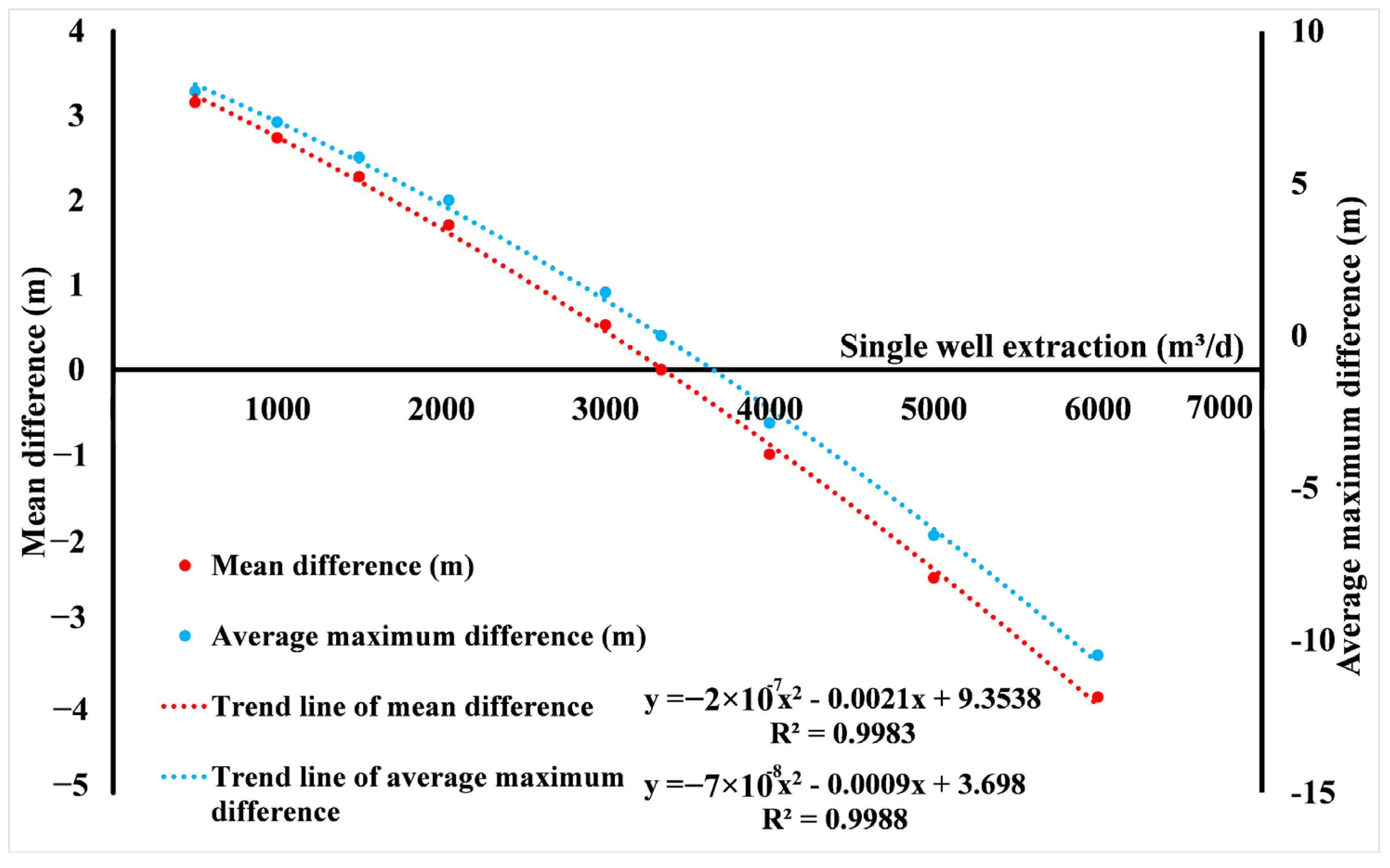
Previous research has established a quadratic relationship fitting the difference between the pumping volume of a single well and the regional average and maximum water level changes, as shown in Figure 2. This paper uses this relationship to regulate regional groundwater extraction based on the ecological water level, ensuring that the groundwater level meets the ecological water level requirements [21]. It is worth noting that this relationship is based on the joint irrigation of groundwater and surface water. Increasing or decreasing groundwater extraction will correspondingly reduce or increase surface water irrigation, thereby maintaining the total irrigation volume and ensuring that the water needs of the vegetation in the irrigation district are met.
Due to the spatiotemporal heterogeneity of water resources in the study area, it is not feasible to implement a unified regulation for the entire region. Therefore, this study employs the natural breaks classification [36] to classify the simulated values of regional groundwater levels. The natural breaks classification method is a data classification technique that groups data into distinct categories based on their similarity within each group and dissimilarity between groups. This classification approach effectively identifies areas with similar trends in groundwater changes, allowing for the establishment of separate control values for each category based on the relationship between groundwater levels and groundwater extraction volumes. By integrating high-precision hydrological models, this approach enables the management of water resources in areas exhibiting spatiotemporal heterogeneity in their distribution.

2.2.4. Calculation of Water Balance in Hydrological Interaction Areas

In order to assess whether the ecological water demand of the Small Lake is met by the total water supply from the hydrological interaction area, separate calculations are conducted for the supply of surface water and groundwater to the lake. For surface water, a hydrological node is established from the Karaxahar River to the inlet of the Small Lake. The runoff from this hydrological node represents the surface water supply to the lake, which is generated by the MIKE-11 module within the MIKE-SHE model. The water balance formula for regional surface water can be expressed as follows:
Q S + Q I + Q R + ET = Q T + Q C + P
In the equation, the following apply: Q S is the supply of surface runoff to the Small Lake from the west branch of the Karaxahar River; Q T is the actual water distribution volume of the west branch of the BLSM; Q I   is the irrigation amount from the surface water; Q C is the recharge amount of groundwater to the river; Q R is the recharge of groundwater from the river; ET is the actual evapotranspiration; P is the precipitation. Among them, Q T is the measured data of the west branch of the BSLM water diversion hub; Q I , Q C , Q R can all be calculated using the water-balance module under the MIKE-SHE model.
Concerning groundwater, the recharge amount to the Small Lake is calculated using the water-balance module in the MIKE-SHE model result analysis. The recharge from the entire hydrological interaction area to the Small Lake should be the sum of the groundwater and surface water recharges to the Small Lake:
Q A = Q S + Q G
In the equation, the following apply: Q A is the total recharge of the Small Lake from the hydrological interaction area; Q G is the amount of groundwater recharge to the Small Lake.
Using the difference between regional ecological water demand and Q A , the adequacy of the Small Lake’s water supply relative to the regional ecological water demand can be determined. If the incoming water volume falls short of the ecological water demand, the water distribution volume of the west branch of the BLSM water diversion hub must be increased until the demand for the Small Lake is met. This water volume represents the minimum inflow required from the west branch of the BSLM water diversion hub to satisfy the ecological water demand. The relationship between the minimum water inflow from the west branch of the BSLM water diversion hub, the ecological water demand of the Small Lake, the total recharge of the Small Lake in the study area, and the water inflow of the entire region must satisfy the following equation:
Q = Q E + Q T Q A
In the equation, the following apply: Q is the minimum inflow of water from the west branch of the BSLM water diversion hub under ecological water demand; and Q E is the ecological water demand of the Small Lake.

2.3. Data Availability

In the study, the data used in the Bohu irrigation area were mainly used for research on groundwater models, ecological water levels, and water balance accounting. The data used in this study encompass various categories such as hydrological data, land use data, socioeconomic data, meteorological data, soil data, future meteorological data, soil moisture data, river network data, irrigation quota data, crop indicator data, etc.
The required data are classified according to their purpose of use. Among them, the data used to establish the hydrological model are of various types and the amount of data is large. They have been clarified in published literature and will not be elaborated here [21]. The main data required for ecological water level calculation are soil data and plant root depth. Data for both parts were provided by the Xinjiang Academy of Agricultural Sciences, whose laboratory measured the effective pore diameter of the soil, the water tension coefficient and the average root depth of the main planting structures in the study area. This study utilizes the provided dataset to calculate the range of ecological water levels in the study area using the capillary method. Furthermore, to diagnose regional groundwater issues, this paper analyzes the measured data from three groundwater observation wells located in the study area during the year 2017. The data required for water balance calculation are surface water data, and the main data come from the hydrological data of the west branch of the BSLM water diversion hub.

3. Results

3.1. Ecological Water Level Calculation and Diagnosis of Groundwater Issues in Irrigation Districts

The excessive exploitation of groundwater in the Bohu irrigation area has led to alarmingly low regional groundwater levels [21]. It poses a serious threat to the ecology of the entire irrigation area, especially in the transition zone of the irrigation area. Quantifying the goals of water resources regulation is the basis of this research. This section calculates the target range of groundwater regulation based on the capillary method.
Since the planting structures in the study area are diverse, existing research methods can specifically calculate the ecological water level for a certain type of planting structure. However, for the entire region, due to the diverse types of crops planted, there is also a situation of intercropping with multiple crops in the same farmland. Therefore, in terms of calculation methods, it affects the calculation of the lower limit of the ecological water level, adding uncertainty to the calculation of the lower limit. In order to reduce uncertainty, this paper uses the proportion of planting areas of different crops as weights and calculates the regional vegetation root depth using a weighted average algorithm as input parameters for determining the lower boundary of the ecological water level. In addition, the coefficient of soil water surface tension ( γ ) and the density of water ( ρ ) were measured at 20 ℃. The effective capillary pore diameter (R) of the soil was also measured in the laboratory. The following table shows the specific values of the parameters required for ecological water level calculation (Table 2). The ecological water levels of the area were calculated, and they range from 1.69 m to 4 m.
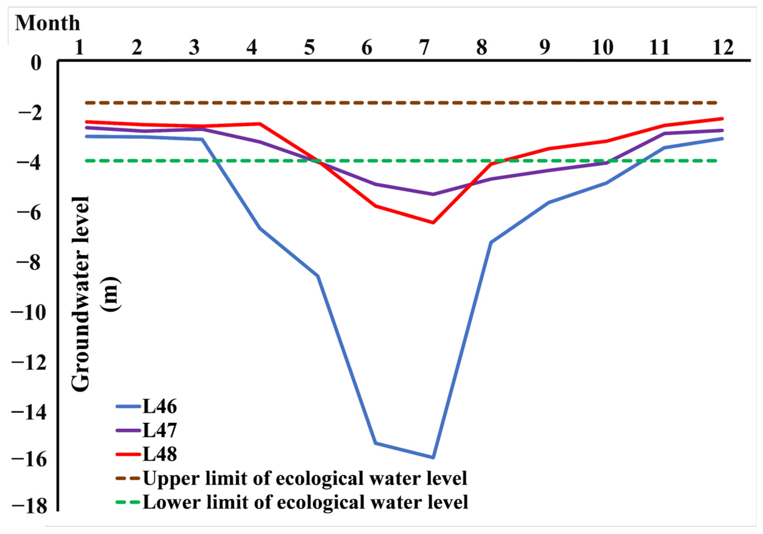
Diagnosis of groundwater problems is a prerequisite for regulation. This section uses the ecological water level as the standard and diagnoses the temporal and spatial changes in regional groundwater in 2017 based on the actual measured values from groundwater observation wells and the values simulated by the MIKE-SHE model. In order to explore whether regional groundwater changes meet ecological water level requirements over a time scale, this paper uses the groundwater observation data and ecological water level range of L46, L48, and L49 in 2017 to draw a line graph to determine the relationship between regional groundwater change trends and ecological water levels, as shown in Figure 3.
The groundwater observation points in the study area of this paper were consistently below the ecological water level in 2017. It was observed that the groundwater levels in the observation wells L46, L47, and L48 were lower than the ecological water level in April, May, and June, respectively, and returned to the ecological water level in November, October, and August, respectively.
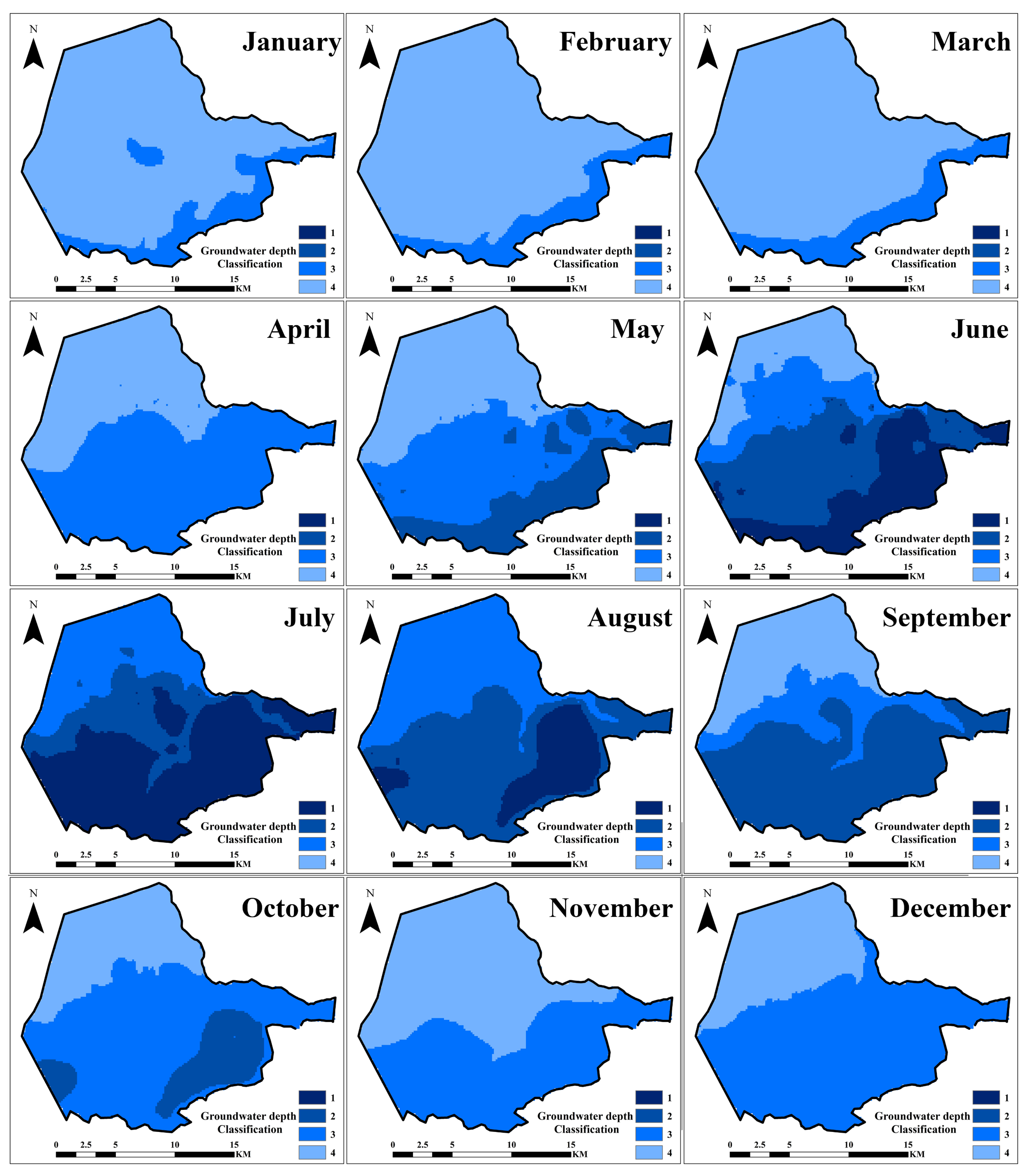
To quantify the groundwater problem across the entire region, this paper employs the natural breakpoint method to reclassify the monthly average groundwater levels in the region based on the simulation results obtained from the MIKE-SHE hydrological model for the year 2017. It divides the groundwater into Level 1 (groundwater depth 9–15 m), Level 2 (groundwater depth 5–9 m), Level 3 (groundwater depth 4–5 m), and Level 4 (groundwater depth 1.69–4 m). The corresponding results are shown in Figure 4. From January to March, the groundwater levels in the entire region remained consistently within the range of ecologically acceptable levels. However, starting from April, approximately 60.05% of the groundwater in the southern part of the irrigation area was observed to decline by around 1 m below the ecological water level. As irrigation activities continue, more and more areas are falling below the lower limit of ecological water levels, and the situation is becoming more and more serious. Level 2 areas began to appear in May, accounting for 23.57% of the total area, while Level 1 areas appeared in June, accounting for 25.93% of the total area. Until July, when the groundwater level reached the deepest point in the region, the Level 1 area accounted for 52.55%. The regional groundwater level began to rise after July, and all Level 1 areas had disappeared by September. At this time, Level 2 areas accounted for approximately 54.42% of the total area. By November, all Level 2 areas had disappeared, while Level 3 areas accounted for 68.44% of the total area. This result indicates that with the onset of irrigation activities, the groundwater has been excessively overexploited, surpassing its sustainable capacity and severely threatening the ecological environment, making urgent regional water resource regulation essential.

3.2. Water Resource Regulation in Irrigation Districts Based on Ecological Water Levels

The results of Section 3.1 indicate that the overall groundwater level in the region is seriously lower than the ecological water level requirements, which will pose a threat to regional ecology. Therefore, this paper is based on the research method in Chapter 2.2.3 of this paper to regulate water resources in interactive areas. Due to the strong spatial and temporal heterogeneity of regional groundwater distribution, it is impossible to uniformly control the entire region. Therefore, this paper uses the results of the above grade classification to separately regulate different grade areas. At the same time, in order to ensure the normal growth of crops, the reduced groundwater irrigation water volume in the model is increased to river water irrigation under the scenario of an unchanged irrigation quota. Further, this paper established the following water resources control plan as shown in Table 3. At present, the designed production capacity of a single well is approximately 3340 m3/d. Negative values in the table represent the amount of groundwater extraction from individual wells that needs to be reduced on this basis. It is evident that the extraction of groundwater from individual wells in Level 1 regions needs to be reduced by 1705 m3/d; in Level 2 regions it needs to be reduced by 389 m3/d; and in Level 3 regions it needs to be reduced by 62.4 m3/d. The entire regulatory plan will start in March and end in October each year.
Using the mining volume in Table 3 for the simulation, select three characteristic points in different grade areas, and extract the trend diagram of the change in groundwater depth with time, as shown in Figure 5. It can be seen that on the time scale, the three characteristic points show a downward trend in the groundwater depth. Among them, the simulated values of L48, which represents the characteristic point of the regulation Level 2 area, and L47, which represents the characteristic point of the regulation Level 3 area, in all time periods are between the ecological water levels. For L48, which represents the characteristic point of the regulation Level 1 area, it also increases the time at the ecological water level by 65%.
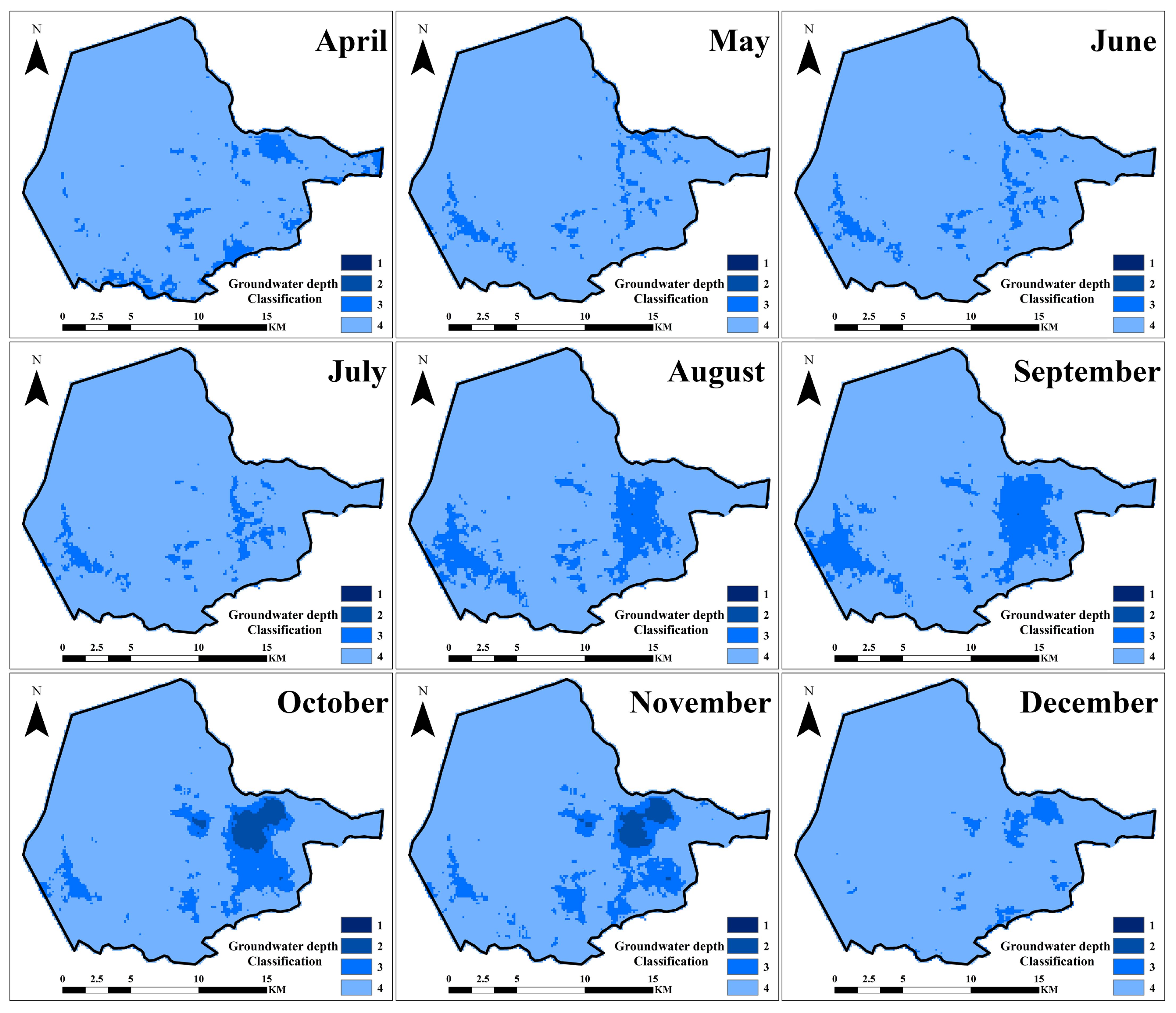
In terms of spatial distribution, the groundwater depth in the area from January to March is basically between ecological water levels. Therefore, through simulation, this article produced a spatial distribution map of risk levels after regional regulation from April to December (Figure 6). It can be seen that the groundwater risk level in the entire region has dropped significantly, and the lowest value of the groundwater depth in the entire region has reached risk Level 2 or below. The area below the ecological water level gradually increased from June to July, then began to decrease rapidly, and reached the minimum area in December. The areas with higher risk levels after regulation are mainly distributed in the delta area between the east branch and west branch of the Karaxahar River, and in the southwest of the study area.
According to statistics (Table 4), since the start of regulation from April to December, all areas classified as Level 1 (with a groundwater depth of 9–15 m) in the entire region have achieved complete elimination, with an average annual elimination rate of 100%. The areas classified as Level 2 (with a groundwater depth of 6–8 m) have also achieved complete elimination except for during June and July, with a reduction in area of 93.29% and 93.32%, respectively, compared to their condition before the regulation, with an average annual elimination rate of 98.51%. The areas classified as Level 3 (groundwater depth of 4–5 m) have achieved an average elimination rate of 72.5% throughout the year. Following the implementation of the regulation, there has been a significant increase in the areas within the ecological water level range, with the most noticeable increases in June and October, increasing by 68.71% and 68.1%, respectively. The average increase throughout the year after regulation is 65.31%. At the same time, the months with more than 90% of the existing areas within the ecological water level range are April, May, October, November, and December. Regulation has resulted in an average annual area within the ecological water level range of 91.25%.

3.3. Water Resources Regulation Based on Ecological Water Demand of Small Lake

Understanding the regional water cycle mechanism is a prerequisite for effective water resource management. Given that this region is a critical area where interactions among rivers, lakes, and groundwater occur, the irrigation district is adjacent to the southern part of the small lake, and changes in irrigation water volume in the irrigation district are closely related to changes in the water volume of the small lake. As mentioned in the introduction, this study builds upon previous research [37] by employing the established MIKE-SHE hydrological model. Based on the actual cropping structure of the region, the actual planting time, irrigation time, irrigation volume, and irrigation frequency for each crop were used as scenario variables. A total of nine cropping structure scenarios were developed for the study area (Table 1). By recalculating the inflow of groundwater and surface water to the Small Lake under each scenario, we determined the relationship between the region’s water supply to the lake and its agricultural activities, exploring the regional water circulation mechanism, allowing for the identification of the optimal agricultural planting structure in the region that satisfies the ecological water demand of the Small Lake. Additionally, in this section, we also calculated the minimum amount of water required for the BLSM diversion hub to meet the ecological water demand of the Small Lake, in order to achieve regional water resource regulation.

3.3.1. Regional Water Cycle Process Mechanism

Based on calculations, Table 5 shows the recharge amount of regional groundwater and surface water to the Small Lake at an annual scale, based on the MIKE-SHE model and the water balance equation. It can be seen that in terms of groundwater, the scenario with rice cultivation has the highest recharge amount to the Small Lake, reaching 10 . 628   ×   10 6   m 3 . The differences in annual groundwater recharge amounts to the Small Lake are not significant among the other scenarios, ranging from 0 . 2   ×   10 4   m 3 to 50   ×   10 4   m 3 . At the same time, a notable observation reveals that the recharge amount of surface water is approximately 84.2 times that of groundwater, far exceeding the groundwater recharge to the Small Lake area, accounting for about 97.8% to 98.7% of the total recharge amount. Among them, rapeseed and spring wheat have the highest recharge amounts to the Small Lake, reaching 538 . 023   ×   10 6   m 3 and 534 . 09   ×   10 6   m 3 , respectively. The recharge of surface water to the Small Lake is crucial for ensuring its ecological safety.
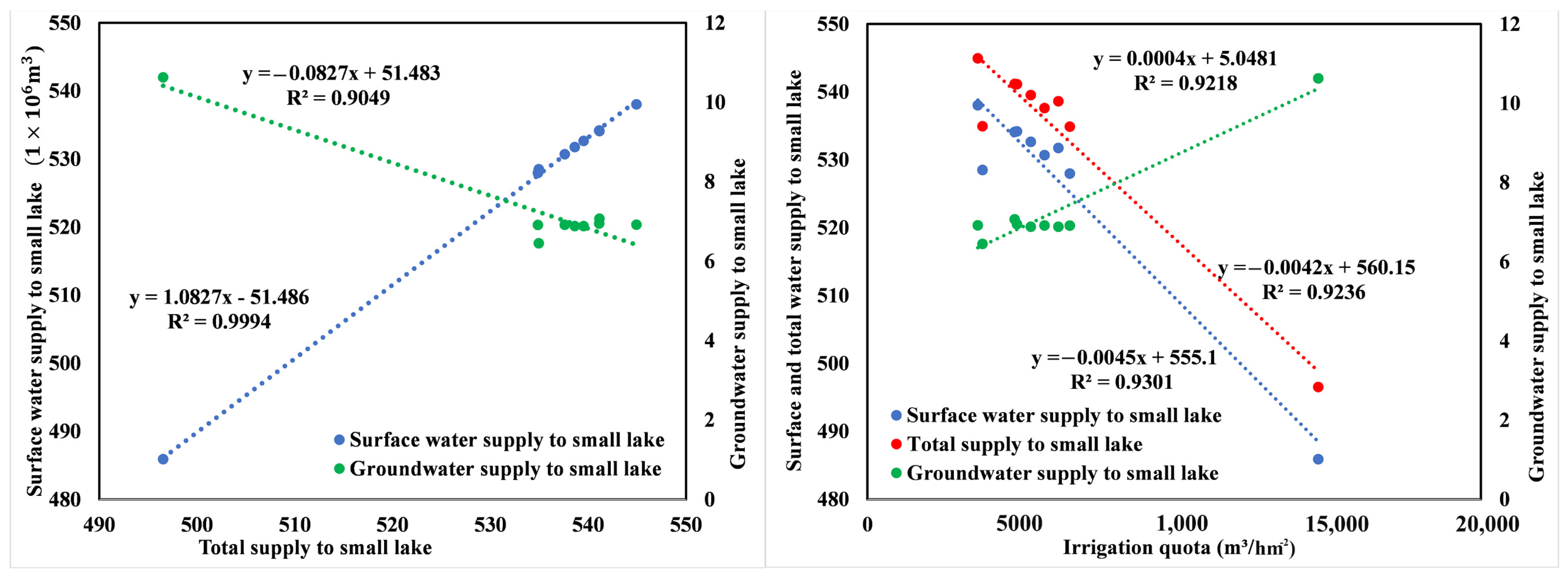
To verify this viewpoint, this paper established the relationship between irrigation quotas and surface water recharge, groundwater recharge, and total recharge (Figure 7). Among them, there is a positive correlation between the irrigation quota and the amount of groundwater recharge for Bosten Lake, with a correlation coefficient of about 0.92. At the same time, there is also a positive correlation between the surface water supply to the Small Lake and the total supply of the irrigation area to the Small Lake, with a correlation coefficient of 0.99. This shows that higher irrigation quotas will increase the recharge of groundwater to the Small Lake, while the recharge of surface water to the Small Lake determines the total recharge of the Small Lake. The correlations between the remaining elements are all negative, and the correlation coefficients are all greater than 0.9. It is not difficult to know from this result that the increase in regional agricultural water consumption will reduce the supply of surface water to the Small Lake, thereby reducing the supply of the Small Lake in the entire region. Meanwhile, with a constant irrigation volume, a higher proportion of surface water irrigation will result in less inflow to the Small Lake.

3.3.2. Regional Water Resources Regulation Plan under the Ecological Water Demand Requirements of Small Lake

Based on existing literature, the estimated minimum annual ecological water demand for the Small Lake is approximately 800 ×   10 6   m 3 [27]. However, according to the simulation results in this study, none of the total supply obtained from the comprehensive scenario simulations based on the background of 2017 can meet this ecological water demand for the Small Lake. Among different planting structures, spring wheat and rapeseed, owing to their highest total supply, are the optimal grain and cash crops in the region with regards to the ecological water demand of the Small Lake, while rice is the least suitable crop for cultivation. The minimum guaranteed allocation water volume per year for the BLSM diversion hub’s west branch to meet the ecological water demand of the Small Lake under different planting structures is shown in Table 6 (Formula (5)). The lowest minimum guaranteed allocation water volume is for rapeseed cultivation at 814.061 ×   10 6   m 3 , and the highest is for rice cultivation at 862.471 ×   10 6   m 3 . For the entire region, to meet the ecological water demand of the Small Lake, the BLSM west branch needs to allocate a minimum of 824 . 632   ×   10 6   m 3 of water resources. In summary, the water volume in the Small Lake area mostly comes from the water volume after the BLSM diversion hub. The activity of groundwater in the region does not cause significant changes in the ecological water supply to the Small Lake. Therefore, to regulate the water supply for the ecological water demand of the Small Lake, the allocation water volume of the BLSM west branch in BLSM should be increased first.
Based on the simulation scenario of the regional regulation of irrigation areas in Section 3.2, the minimum water distribution volume of the west branch of the BLSM water diversion hub under this scenario was calculated. This water volume is the minimum water distribution volume of the west branch of the BLSM water diversion hub that meets both the ecological security requirements of the irrigation area and the ecological water demand requirements of the Small Lake, which is 831.902 ×   10 6   m 3 . It is evident that for oasis irrigation areas in arid regions, limited water resources remain a critical threat to the ecological security of the oasis. This means that the entire region needs further optimization of the industrial structure, improvement in water resource utilization efficiency, and reduction in agricultural water consumption. In water-deficient years, the region should prioritize meeting the ecological water demand of the Small Lake area, and then, based on surplus water, implement the regulation of regional groundwater using the relationship between groundwater levels and extraction quantities utilized in Section 2.2.4, ensuring that the groundwater in the irrigation area falls within the range of ecological water levels.

4. Discussion

4.1. Discussion on the Calculation of Ecological Water Levels

The essence of ecological issues in irrigation districts lies in the irrational use of water resources. Ecological water levels combine ecology and hydrology to identify the hydrological issues underlying ecological problems, which is highly characteristic of oases in arid irrigation districts. This study calculates the regional ecological water level using the capillary method to diagnose water resource utilization issues and regulate water resources to alleviate regional ecological problems. Although this study is the first to explore the ecological water level in the hydrological interaction region of Bohu County, there are numerous studies on ecological water levels in similar areas or other parts of the Tarim River Basin. Different studies, using various methods depending on their objectives, have reported results generally within the range of 1.5 to 4 m. For instance, two studies used the relationship between NDVI and plant root depth and the MODFLOW model to simulate salt transport, suggesting that the ecological water level for effective salinization prevention in the Yanqi Basin oasis irrigation district should be 2.5 m to 3 m [38] and 2 m to 4 m [39], respectively. Additionally, five other studies focusing on vegetation growth and salinization prevention have suggested that the ecological water level in the Tarim River Basin should be 3 m to 4 m [40], 3.5 m to 5 m [41]; 2 m to 4 m [42]; 2 m to 4.5 m [43]; and 2 m to 4 m [44]. Stress experiments on vegetation have also shown that the optimal groundwater level for crop growth in southern Xinjiang is between 1.5 m and 3 m [45]. The calculation results of this study show a strong similarity with these studies, indicating that the ecological water level boundary of 1.69 to 4 m calculated using the capillary method is reasonable. Additionally, the uniqueness of the methods and the slight differences in the results also reflect the specific characteristics of our study area.

4.2. Discussion on the Problems Facing Regional Groundwater and Regulatory Solutions

The problem of groundwater overexploitation is a common problem faced in many oasis irrigation areas [46]. Overexploitation will seriously damage the sustainability of oasis groundwater resources [47]. The continuous depletion of groundwater resources will also cause irreversible damage to the surface ecology [48]. The groundwater regulation method based on individual well extraction has achieved good results. This method significantly reduces the time required for scenario simulations and improves simulation efficiency. At the same time, this method also realizes water resource regulation in areas with high spatiotemporal heterogeneity in water distribution characteristics, solving the key scientific issues mentioned in the introduction. This method can be implemented in the study area due to the complete agricultural infrastructure in the study area and clear regulations on irrigation activities; regional groundwater changes are relatively regular. By using this method, the average groundwater level in the region is effectively lowered to a range of 1.69–4 m, which is within the ecological water level. The result not only ensures the ecological security of the region but also ensures the recoverability of groundwater within the year so that it will not continue to decline. However, for most oasis irrigation areas, groundwater does not exhibit significant spatial and temporal variations [49,50], making regulation more challenging. In such areas, the region needs to be divided into multiple smaller areas with more consistent trends using hydrological models. Then, individual regulation plans can be established for each small area based on the ecological water level as a standard.
It is worth noting that in this study, the regulation did not achieve the 100% placement of regional groundwater within the ecological water level. This is because the regulation scheme in this study is based on the relationship between the groundwater level and groundwater extraction. In order to further increase the area within the ecological water level, separate control measures need to be implemented in areas or months when the water resources exceed the ecological water level. Although this may slightly improve the completion of regulation, it goes against the original intention of the approach. Additionally, if the pumping volume of groundwater is further increased, it means more water resources will be introduced from the river into the irrigation area. This can lead to the problem of groundwater levels exceeding the ecological water level in certain locations within the entire area [51]. For irrigated areas in arid areas, soil salinization caused by excessive groundwater levels seriously threatens the growth of crops. In these areas, not only the ecological impact of the water level but also the ecological impact of water and salt needs to be considered [52]. Therefore, not exceeding the upper boundary of the ecological water level is also a key principle of regulation.
Overall, the water resource issues in the Bohu irrigation area primarily relate to the allocation and utilization of water resources against the backdrop of modern agricultural development. The advancement of modern agriculture implies more efficient water resource utilization, which is crucial for addressing ecological problems in oasis irrigation areas in arid regions, as concluded in Section 3.3.2 of this paper. However, the unreasonable utilization of water resources accompanying modern agricultural development may disrupt the original regional water cycle, leading to issues such as the misallocation of water resources observed in this study. Therefore, for the irrigation district, while advancing more scientifically based agricultural practices, it is essential to continuously monitor whether the regional water cycle is moving towards a positive and sustainable direction.

4.3. Discussion on the Regional Water Resource Circulation Mechanism and Overall Regional Water Resource Regulatory Solutions

The exploration of the regional water cycle mechanism is the premise and foundation of this study. It is worth noting that, in general, lakes in inland rivers are the lowest points in the regional topography. Under the influence of the hydraulic gradient of the aquifer, groundwater is the main source of water for lakes [53,54]. In some regions, groundwater recharge is even the sole way to maintain the water level of lakes [18,55]. However, in the study area of this article, groundwater contributes only 1.2–2.13% of the total recharge to the lakes. This is because, with the process of groundwater extraction, the water level of the aquifers in the Small Lake areas is significantly higher than that in the irrigation areas. As a result of the hydraulic gradient, there is a phenomenon of groundwater from the Small Lake recharging back into the oasis irrigation areas. The duration of agricultural irrigation activities throughout the year varies from 3 to 7 months, so recharging is common during this period. Additionally, groundwater plays a buffering role in regulating the environment. Its response to environmental changes is slower compared to surface water, resulting in a much smaller increase in groundwater recharge compared to the decrease in surface water recharge. This is the main reason for the negative correlation between the total recharge of the Small Lake and the groundwater recharge, under the condition of constant irrigation quotas.
The primary contribution of this paper is the exploration of hydrological interaction mechanisms across different regions of the water cycle, and the quantification and implementation of water resource regulation schemes aimed at multiple ecological restoration goals in regions characterized by high spatiotemporal heterogeneity in water resource distribution. Different from regulation studies that focus on a single factor [56,57,58,59], this study fully considers the integrity of interactions among rivers, lakes, and groundwater in the oasis, reducing the risk of damaging other links in the ecological systems due to the limitations of regulation objectives. Different from basin-scale water resource allocation [60,61,62,63], this paper focuses more on understanding the mechanisms of regional hydrological cycles, which is more conducive to localized and precise water resource management plans. This research aims to maintain the ecological security of oases in arid regions and provides a valuable case for water resource management studies in other arid areas. Therefore, our future research will use this study area as a typical case to explore the similarities and differences in water resource cycling mechanisms, ecological security threat factors, and hydrological model responses under different water resource management practices by comparing it with other oasis irrigation areas in arid regions. This will deepen our understanding of hydrology in inland river oasis irrigation districts. Furthermore, for this study area, we will simulate the water–salt cycling process and the transport of chemical pollutants based on the water quantity model, thereby integrating both ecological and environmental aspects to develop a comprehensive regional water resource management plan.

5. Conclusions

Water resources are a vital limiting factor for oasis development, and in recent years, the expanding agricultural land has altered the water cycle process in the irrigation area of Bohu County, Xinjiang. The uneven distribution of water resources has led to two main ecological threats in the region. Firstly, the excessively low groundwater levels result in an increased risk of soil desertification in the transition zone of the irrigation area. Secondly, the ecological water demand of the Small Lake area has not been adequately guaranteed, resulting in vegetation degradation.
To address the first regional ecological issue, this paper calculated the ecological water level in the irrigation area and diagnosed the ecological problems caused by groundwater. Using the established MIKE-SHE hydrological model and based on the relationship between individual well extraction and groundwater levels, the regional water resources are regulated with the ecological water level as the target, achieving water resource management in areas with high spatiotemporal heterogeneity in water resource distribution. To address the second ecological issue, this article calculated the impact of changes in agricultural planting structures on the inflow to the Small Lake. By exploring the water cycle mechanisms in the interaction zone of rivers, lakes, and groundwater, the optimal oasis agricultural planting structure was determined under the ecological water requirements of the Small Lake. Additionally, based on the zoning regulation of water resources in the irrigation area, a water resource management approach was proposed to ensure both the groundwater safety in the irrigation area and the ecological safety of the Small Lake. Thus, this paper implements and quantifies a joint sustainable control plan for groundwater and surface water in areas with high spatiotemporal heterogeneity in water resource distribution, providing a valuable reference for the protection of ecological security in other oases. The main conclusions are as follows:
(1)
The sustainable water level of groundwater in the Bohu irrigation area is 1.69–4 m. On the time scale, the regional average time above the ecological water level is 161 days, accounting for 44.1% of the total time, and is mainly concentrated during the irrigation period. On a spatial scale, the monthly average area of the region that exceeds the ecological water level accounts for 74% of the region’s total area.
(2)
Groundwater regulation based on the extraction rate of individual wells can effectively improve regional groundwater problems. After regulation, on a time scale, the average duration of surpassing the ecological water level in the region for 132 days returns to the range of the ecological water level, with a regulation completion rate of 89.1%. In terms of spatial scale, the average area above the ecological water level increases by 65.31% compared to before regulation, reaching a total area of 91.25%.
(3)
The recharge amount of surface water to the Small Lake is much greater than that of groundwater, and it is the decisive factor in the total recharge of the Small Lake. For the regulation of regional water resources, the amount of water coming from the west branch of the BLSM water diversion hub must be guaranteed. Under different planting scenarios, the average minimum allocated water volume of the west branch of the BLSM water diversion hub needs to meet 824.632 ×   10 6   m 3 to meet the ecological water demand requirements of the Small Lake. The minimum allocated water volume of the west branch of the BLSM water diversion hub, which simultaneously meets the requirements of groundwater regulation and Small Lake ecological water demand, is 831.902 ×   10 6   m 3 .

Author Contributions

Conceptualization, C.G. and T.L.; data curation, C.G., T.L., Y.N., and X.P.; formal analysis, C.G.; methodology, C.G., Y.N. and X.P.; supervision, T.L.; validation, C.G., Y.N., and X.P.; writing—original draft, C.G.; writing—review and editing, C.G. All authors have read and agreed to the published version of the manuscript.

Funding

This research was funded by Third Xinjiang Scientific Expedition Program, Grant No. 2021xjkk1400; K.C. Wong Education Foundation, Grant No. GJTD-2020-14; CAS Research Center for Ecology and Environment of Central Asia, Grant No. Y934031; Tianshan Talent Training Program of Xinjiang Uygur Autonomous region, Grant No. 2022TSYCLJ0011; Key R&D Program of Xinjiang Uygur Autonomous Region, Grant No. 2022B03021; Tianshan Talent Training Program of Xinjiang Uygur Autonomous region, Grant No. 2022TSYCLJ0056.

Data Availability Statement

The original contributions presented in the study are included in the article; further inquiries can be directed to the corresponding authors.

Conflicts of Interest

The authors declare no conflicts of interest.

References

  1. Chen, P.; Wang, S.; Liu, Y.X.; Wang, Y.J.; Wang, Y.P.; Zhang, T.G.; Zhang, H.Y.; Yao, Y.; Song, J.X. Water Availability in China’s Oases Decreased between 1987 and 2017. Earth’s Future 2023, 11, e2022EF003340. [Google Scholar] [CrossRef]
  2. Zhang, J.; Zhang, P.; Gu, X.C.; Deng, M.J.; Lai, X.Y.; Long, A.H.; Deng, X.Y. Analysis of Spatio-Temporal Pattern Changes and Driving Forces of Xinjiang Plain Oases Based on Geodetector. Land 2023, 12, 1508. [Google Scholar] [CrossRef]
  3. Tang, X.; Li, S. Suitable Scale of Oases in Arid Regions: A Case Study of the Middle Reaches of the Heihe River Basin, China. Polish J. Environ. Stud. 2023, 32, 2337–2344. [Google Scholar] [CrossRef] [PubMed]
  4. Yi, F.; Lu, Q.; Li, Y.H.; Wang, Z.J.; Yao, B.; Yang, Q.K.; Wang, J. Ecological Vulnerability Assessment of Natural Oasis in Arid Areas: Application to Dunhuang, China. Ecol. Indic. 2023, 149, 110139. [Google Scholar] [CrossRef]
  5. Eziz, M.; Yimit, H.; Zhang, Y. The Drivers and Ecological Effects of Spacio-Temporal Dynamics Farmland in Yanqi Basin. Agric. Res. Arid Areas 2014, 32, 192–197. [Google Scholar]
  6. Wang, S.X.; Dong, X.G.; Wu, B. Modelling and Controlling of Groundwater and Salt Movement in Yanqi Basin, Northwestern China. In Proceedings of the 7th International Groundwater Quality Conference, Lanzhou, China, 13–18 June 2010; Volume 342, pp. 491–495. [Google Scholar]
  7. Wang, X.; Yu, Z.; Wang, J.; Zhang, J.; Wang, X.; Yu, Z.; Wang, J.; Zhang, J. (Eds.) Carbon Cycle in the Changing Arid Land of China: Yanqi Basin and Bosten Lake; Springer: Singapore, 2018; ISBN 2197-9596. [Google Scholar]
  8. Yan, Y.J.; Li, J.G.; Li, J.L.; Jiang, T. Spatiotemporal Changes in the Supply and Demand of Ecosystem Services in the Kaidu-Kongque River Basin, China. Sustainability 2023, 15, 8949. [Google Scholar] [CrossRef]
  9. Maierhaba, M.; Yusufujiang, R.; Anniwaer, A.; Tashigen, J. Dynamic Variation of Phragmites Australis Wetland in the Bosten Lake Basin and Its Driving Factors in Recent 26 Years. Arid Zo. Res. 2016, 33, 797–804. [Google Scholar]
  10. Zhang, H.; Li, X.; Yan, K.; Liu, B. Landscape Dynamic Changes of Small lake in Bosten Lake. Trans. Oceanol. Limnol. 2017, 8, 23–30. [Google Scholar]
  11. Liu, Y.; Zhong, R.; Duan, Y.; Cheng, Y.; Jiang, L.; Li, J.; Liu, T. Threshold of Ecological Water Demands for the Small Lake Wetland of Bosten Lake. Arid L. Geogr. 2021, 44, 1525–1533. [Google Scholar]
  12. Zhao, J.; Zhou, J.; Liang, C.; Ying, Z.; Bao, Z.; Qian, L. Hydrogeochemical Process of Evolution of Groundwater in Plain Area of Yanqi, Xinjiang. Huanjing Huaxue-Environ. Chem. 2017, 36, 1397–1406. [Google Scholar] [CrossRef]
  13. Xia, J.; Wu, X.; Zhan, C.; Qiao, Y.; Hong, S.; Yang, P.; Zou, L. Evaluating the Dynamics of Groundwater Depletion for an Arid Land in the Tarim Basin, China. Water 2019, 11, 186. [Google Scholar] [CrossRef]
  14. Yuan, L.; Yuan, T.; Fengqing, J.; Yajun, W.; Hu, R. Study on Hydrological Features of the Kaidu River and the Bosten Lake in the Second Half of 20th Century. J. Glaciol. Geocryol. 2003, 25, 215–218. [Google Scholar]
  15. Rusuli, Y.; Li, L.H.; Li, F.D.; Eziz, M. Water-Level Regulation for Freshwater Management of Bosten Lake in Xinjiang, China. Water Sci. Technol. Supply 2016, 16, 828–836. [Google Scholar] [CrossRef]
  16. Bian, D.H.; Yang, X.H.; Lu, Y.; Chen, H.; Sun, B.Y.; Wu, F.F.; Chen, Y.J.; Xiang, W.Q. Analysis of the Spatiotemporal Patterns and Decoupling Effects of China’s Water Resource Spatial Equilibrium. Environ. Res. 2023, 216, 114719. [Google Scholar] [CrossRef]
  17. Pan, X.; Wang, W.; Liu, T.; Huang, Y.; De Maeyer, P.; Guo, C.; Ling, Y.; Akmalov, S. Quantitative Detection and Attribution of Groundwater Level Variations in the Amu Darya Delta. Water 2020, 12, 2869. [Google Scholar] [CrossRef]
  18. Pan, X.; Wang, W.; Liu, T.; Bao, A.; Chen, X.; Akmalov, S.; De Maeyer, P.; Van de Voorde, T. Modeling the Effects of Improved Irrigation Methods in a Groundwater System: A Case Study from the Amu Darya Delta, Uzbekistan. J. Hydrol. 2023, 625, 129987. [Google Scholar] [CrossRef]
  19. Narany, T.S.; Ramli, M.F.; Fakharian, K.; Aris, A.Z. A GIS-Index Integration Approach to Groundwater Suitability Zoning for Irrigation Purposes. Arab. J. Geosci. 2016, 9, 502. [Google Scholar] [CrossRef]
  20. Li, M.Y.; Xie, Y.Q.; Dong, Y.H.; Wang, L.H.; Zhang, Z.Y. Review: Recent Progress on Groundwater Recharge Research in Arid and Semiarid Areas of China. Hydrogeol. J. 2023, 32, 9–30. [Google Scholar] [CrossRef]
  21. Guo, C.; Liu, T.; Niu, Y.; Liu, Z.; Pan, X.; De Maeyer, P. Quantitative Analysis of the Driving Factors for Groundwater Resource Changes in Arid Irrigated Areas. Hydrol. Process. 2021, 35, e13967. [Google Scholar] [CrossRef]
  22. Zhai, J.; Dong, Y.; Qi, S.; Zhao, Y.; Liu, K.; Zhu, Y. Advances in Ecological Groundwater Level Threshold in Arid Oasis Regions. J. China Hydrol. 2021, 41, 7–14. [Google Scholar]
  23. Ali, R.; Elliott, R.L.; Ayars, J.E.; Stevens, E.W. Soil Salinity Modeling over Shallow Water Tables. I: Validation of LEACHC. J. Irrig. Drain. Eng. 2000, 126, 223–233. [Google Scholar] [CrossRef]
  24. Wang, Y.; Chen, M.; Yan, L.; Yang, G.; Ma, J.; Deng, W. Quantifying Threshold Water Tables for Ecological Restoration in Arid Northwestern China. Groundwater 2020, 58, 132–142. [Google Scholar] [CrossRef] [PubMed]
  25. Huang, F.; Zhang, Y.D.; Zhang, D.R.; Chen, X. Environmental Groundwater Depth for Groundwater-Dependent Terrestrial Ecosystems in Arid/Semiarid Regions: A Review. Int. J. Environ. Res. Public Health 2019, 16, 763. [Google Scholar] [CrossRef] [PubMed]
  26. Ling, Y.; Liu, Y.; Peng, J.; Zhong, R.; Huang, Y.; Tie, L.; Cheng, Y.; Zhang, Y.; Jiang, L.; Yu, M. Analysis of Minimum Ecological Water Level and Water Surplus in Xiaohu Lake District in Bosten Lake. Environ. Eng. 2020, 38, 26–32, 60. [Google Scholar]
  27. Peng, J.; Huang, Y.; Liu, T.; Zhang, Y.; Cheng, Y.; Jiang, L. Ecological Water Requirement Accounting of Small Lake Wetland of Bosten Lake Based on Ecosystem Services Value. J. Hydroecol. 2020, 41, 21–30. [Google Scholar]
  28. Zhu, Z.; Zhou, J. The Formation of Two-Sides Oblique Compression and Substrate Contraction of Mesozoic Yanqi Basin. Pet. Explor. Dev. 2003, 30, 123–126. [Google Scholar]
  29. Liu, X.; Lin, S.; He, M.; He, Y.; Yan, Y. Identification of Characteristics of Yanqi Mesozoic Proatotype Basin. Xinjiang Pet. Geol. 2002, 23, 392–393. [Google Scholar]
  30. Jia, H.X.; Wang, X.; Xiao, J.J.; Jang, S.L.; Li, J.; Zhao, Y.F.; Ye, W.L. Simulated Soil Organic Carbon Stocks in Northern China’s Cropland under Different Climate Change Scenarios. Soil Tillage Res. 2021, 213, 105088. [Google Scholar] [CrossRef]
  31. Huang, Y.; Chen, X.; Bao, A.; Liu, T.; Feng, X. Daily Flow Modeling in Arid Ungauged Basin. Adv. Water Sci. 2009, 20, 332–336. [Google Scholar]
  32. Lukjan, A.; Swasdi, S.; Chalermyanont, T. Importance of Alternative Conceptual Model for Sustainable Groundwater Management of the Hat Yai Basin, Thailand. Procedia Eng. 2016, 154, 308–316. [Google Scholar] [CrossRef]
  33. Cai, Y.F.; Zhang, F.; Shi, J.C.; Johnson, V.C.; Ahmed, Z.; Wang, J.G.; Wang, W.W. Enhancing SWAT Model with Modified Method to Improve Eco-Hydrological Simulation in Arid Region. J. Clean. Prod. 2023, 403, 136891. [Google Scholar] [CrossRef]
  34. Xiao, H.; Cheng, G.; Li, C.; Ren, J.; Wang, S. Eco-Hydrological Observational Experiments of the Heihe River Basin and Integrated Eco-Water Management Research at Watershed Scale. Adv. Earth Sci. 2008, 23, 666–670. [Google Scholar]
  35. DHI MIKE. SHE USER MANUAL; 2017. [Google Scholar]
  36. Golian, S.; Saghafian, B.; Sheshangosht, S.; Ghalkhani, H. Comparison of Classification and Clustering Methods in Spatial Rainfall Pattern Recognition at Northern Iran. Theor. Appl. Climatol. 2010, 102, 319–329. [Google Scholar] [CrossRef]
  37. Guo, C.; Liu, T.; Huang, Y.; Niu, Y.; Zhang, Y.; Cheng, Y.; Jiang, L. Impact of Oasis Agriculture on the Ecological Water Requirement of the Small Lakes near Bosten Lake. J. Hydroecol. 2020, 41, 31–38. [Google Scholar]
  38. Wang, S.; Wu, B.; Yang, P.; Li, X.; Dong, X. Determination of the Ecological Groundwater Depth Considering Ecological Integrity over Oasis Irrigation Areas in the Yanqi Basin. Resour. Sci. 2011, 33, 422–430. [Google Scholar]
  39. Zhong, R. Research and Application Practice of Distributed Three-Dimensional Water and Salt Transport Model in Arid Oasis Area. Ph.D. Thesis, Xinjiang Agricultural University, Urumqi, China, 2008. [Google Scholar]
  40. Ma, J.; Zhu, Z.; Li, J. The Role of Groundwater in the Fragile Ecological Environment at the Southern Edge of the Taklimakan Desert. J. Lanzhou Univ. 2000, 36, 88. [Google Scholar]
  41. Xu, H.; Chen, Y.; Yang, G. Effect of Translating Water on Vegetation at the Lower Reaches of Tarim River. Huanjing Kexue 2003, 24, 18–22. [Google Scholar]
  42. Hao, X.; Li, W.; Chen, Y. Water Table and the Desert Riparian Forest Community in the Lower Reaches of Tarim River, China. Acta Phytoecol. Sin. 2008, 32, 838–847. [Google Scholar]
  43. Wang, R.; Song, Y.; Fan, Z.; Ma, Y. Estimation of Ecological Water Demand in the Tarim Basin’s “Four Sources and One Main Stream. J. Soil Water Conserv. 2001, 15, 19. [Google Scholar]
  44. Fan, Z.; Ma, Y.; Zhang, H. Determination of the Ecological Groundwater Level and Its Reasonable Depth in the Tarim River Basin. Arid L. Geogr. 2004, 01, 8–13. [Google Scholar]
  45. Yang, P.; Wu, B.; Wang, S.; Dong, X.; Liu, L. Research on Irrigation Schedule of Cotton Drip Irrigation under Plastic Film Based on the Different Ground Water Table in Arid Areas. Agric. Res. Arid Areas 2014, 32, 76–82. [Google Scholar]
  46. Wang, W.R.; Chen, Y.N.; Chen, Y.P.; Wang, W.H.; Zhang, T.J.; Qin, J.X. Groundwater Dynamic Influenced by Intense Anthropogenic Activities in a Dried-up River Oasis of Central Asia. Hydrol. Res. 2022, 53, 532–546. [Google Scholar] [CrossRef]
  47. Das, J.; Rahman, A.; Mandal, T.; Saha, P. Challenges of Sustainable Groundwater Management for Large Scale Irrigation under Changing Climate in Lower Ganga River Basin in India. Groundw. Sustain. Dev. 2020, 11, 100449. [Google Scholar] [CrossRef]
  48. Hao, A.B.; Zhang, Y.L.; Zhang, E.Y.; Li, Z.H.; Yu, J.; Wang, H.; Yang, J.F.; Wang, Y. Review: Groundwater Resources and Related Environmental Issues in China. Hydrogeol. J. 2018, 26, 1325–1337. [Google Scholar] [CrossRef]
  49. Yan, L.; Chen, M.J.; Hu, P.; Li, D.L.; Wang, Y. An Analysis on the Influence of Precipitation Infiltration on Groundwater under Different Irrigation Conditions in the Semi-Arid Area. Water Supply 2021, 21, 1111–1118. [Google Scholar] [CrossRef]
  50. Bennett, G. Assessment of Temporal and Spatial Variability of Irrigation Groundwater Quality on the Flanks of Mount Meru, Northern Tanzania. Groundw. Sustain. Dev. 2023, 20, 100880. [Google Scholar] [CrossRef]
  51. Meredith, E.; Blais, N. Quantifying Irrigation Recharge Sources Using Groundwater Modeling. Agric. Water Manag. 2019, 214, 9–16. [Google Scholar] [CrossRef]
  52. Gao, Y.Y.; Chen, J.; Qian, H.; Wang, H.K.; Ren, W.H.; Qu, W.G. Hydrogeochemical Characteristics and Processes of Groundwater in an over 2260 Year Irrigation District: A Comparison between Irrigated and Nonirrigated Areas. J. Hydrol. 2022, 606, 127437. [Google Scholar] [CrossRef]
  53. Song, Y.Y.; Zhang, Q.; Melack, J.M.; Li, Y.L. Groundwater Dynamics of a Lake-Floodplain System: Role of Groundwater Flux in Lake Water Storage Subject to Seasonal Inundation. Sci. Total Environ. 2023, 857, 159414. [Google Scholar] [CrossRef]
  54. Xu, S.; Frey, S.K.; Erler, A.R.; Khader, O.; Berg, S.J.; Hwang, H.T.; Callaghan, M.V.; Davison, J.H.; Sudicky, E.A. Investigating Groundwater-Lake Interactions in the Laurentian Great Lakes with a Fully-Integrated Surface Water-Groundwater Model. J. Hydrol. 2021, 594, 125911. [Google Scholar] [CrossRef]
  55. Qian, Y.B.; Wu, Z.N.; Zhang, L.Y.; Zhou, H.R.; Wu, S.X.; Yang, Q. Eco-Environmental Evolution, Control, and Adjustment for Aibi Lake Catchment. Environ. Manag. 2005, 36, 506–517. [Google Scholar] [CrossRef] [PubMed]
  56. Fu, A.H.; Li, W.H.; Chen, Y.N.; Liu, Y.T. Suitable Oasis Scales under a Government Plan in the Kaidu-Konqi River Basin of Northwest Arid Region, China. PeerJ 2018, 6, e4943. [Google Scholar] [CrossRef] [PubMed]
  57. Gan, Z.G.; Zhao, H.L.; Jiang, Y.Z.; You, J.J.; Kang, J. River Basin Water Resources Multi- Objective Regulation Theory and Method Research. Appl. Mech. Mater. 2011, 71–78, 4721–4727. [Google Scholar] [CrossRef]
  58. Pan, B.Z.; Yuan, J.P.; Zhang, X.H.; Wang, Z.Y.; Chen, J.; Lu, J.Y.; Yang, W.J.; Li, Z.W.; Zhao, N.; Xu, M.Z. A Review of Ecological Restoration Techniques in Fluvial Rivers. Int. J. Sediment Res. 2016, 31, 110–119. [Google Scholar] [CrossRef]
  59. Pander, J.; Geist, J. Ecological Indicators for Stream Restoration Success. Ecol. Indic. 2013, 30, 106–118. [Google Scholar] [CrossRef]
  60. Zhang, F.; Zhang, Y.H. A Multi-Objective Optimization Prediction Approach for Water Resources Based on Swarm Intelligence. Earth Sci. Inform. 2021, 14, 457–468. [Google Scholar] [CrossRef]
  61. Dong, Z.C.A.; Ni, X.K.; Chen, M.F.; Yao, H.Y.; Jia, W.H.; Zhong, J.X.; Ren, L. Time-Varying Decision-Making Method for Multi-Objective Regulation of Water Resources. Water Resour. Manag. 2021, 35, 3411–3430. [Google Scholar] [CrossRef]
  62. Candido, L.A.; Coêlho, G.A.G.; de Moraes, M.; Florêncio, L. Review of Decision Support Systems and Allocation Models for Integrated Water Resources Management Focusing on Joint Water Quantity-Quality. J. Water Resour. Plan. Manag. 2022, 148, 03121001. [Google Scholar] [CrossRef]
  63. Yao, Y.; Fu, B.J.; Liu, Y.X.; Wang, Y.J.; Song, S. The Contribution of Ecosystem Restoration to Sustainable Development Goals in Asian Drylands: A Literature Review. Land Degrad. Dev. 2021, 32, 4472–4483. [Google Scholar] [CrossRef]
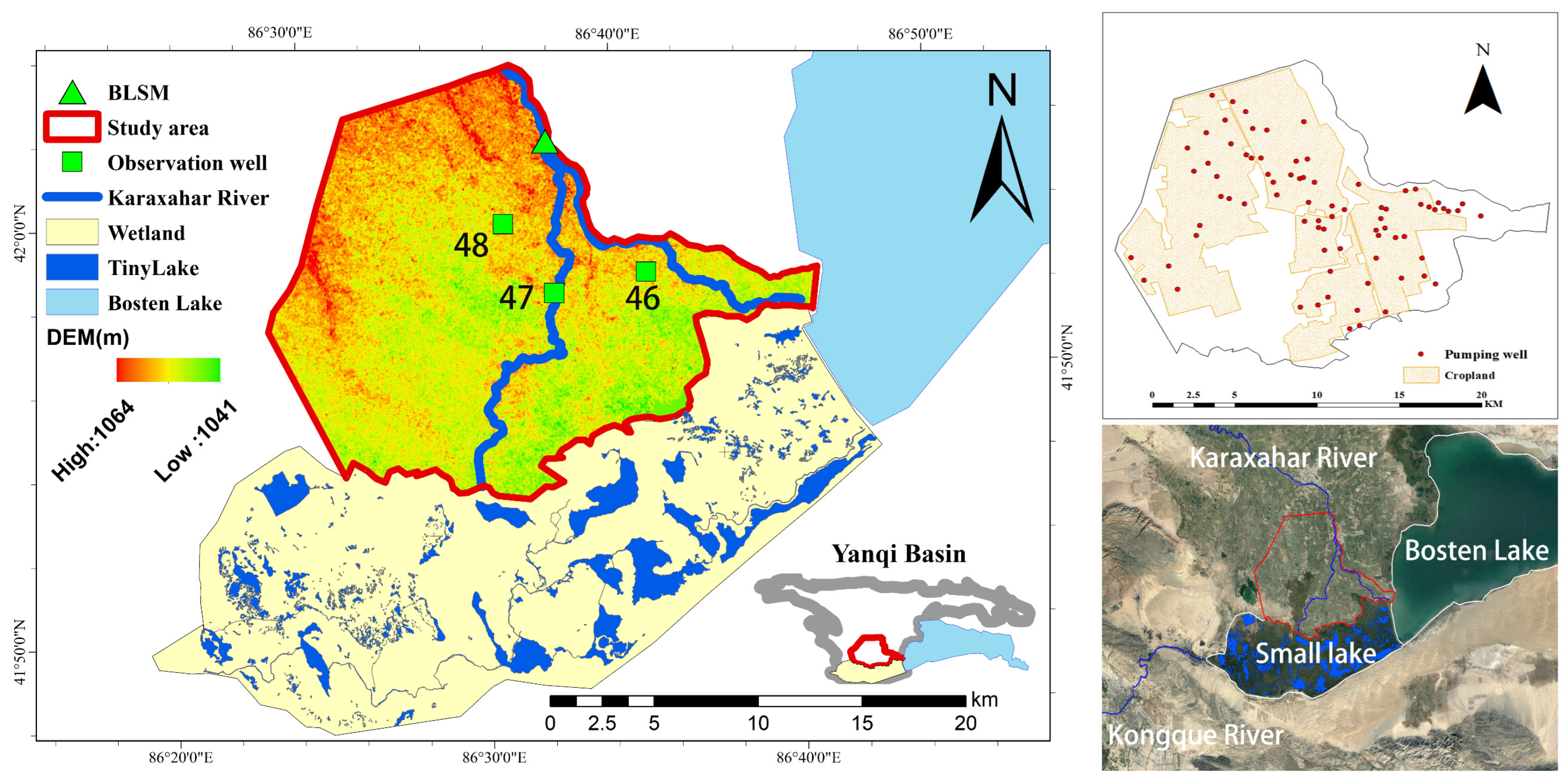
Figure 1. Geographical location, land use type, elevation, pumping well, hydrological observation points of Bohu irrigation area.
Water 16 02708 g001
Figure 2. The relationship between groundwater exploitation and water level change in Bohu irrigation area.
Water 16 02708 g002
Figure 3. The relationship between monthly-scale groundwater changes and ecological water levels in Bosten Lake in 2017.
Water 16 02708 g003
Figure 4. Grading chart of monthly simulation results of MIKE-SHE hydrological model based on the natural breakpoint method.
Water 16 02708 g004
Figure 5. The relationship between the water level changes before and after the regulation of the three characteristic points of the Bohu irrigation area in 2017.
Water 16 02708 g005
Figure 6. Spatial scale distribution map of groundwater after regulation in the Bohu County irrigation area based on the ecological water level standard.
Water 16 02708 g006
Figure 7. The relationship between irrigation quota and surface water recharge, groundwater recharge, and total recharge in Bohu irrigation area (left); the relationship between total recharge, groundwater recharge, and surface water recharge in Bohu irrigation area (right).
Water 16 02708 g007
Table 1. Agricultural planting structure information.
No.Type of CropsIrrigation Start MonthIrrigation End MonthNumber of
Irrigations
Amount of Each Irrigation (m3∙hm−2)Conventional Irrigation 75% Guaranteed Rate
Irrigation Quota (m3∙hm−2)
1Spring wheatMid-AprilEarly July5–8 450~6754800
2Spring cornEarly JuneEarly September6–8600~7505325
3RiceEarly MayLate August114,70014,700
4CottonLate MayMid-August8–10450~6006600
5BeetsEarly JuneLate August7–9525~6005775
6VegetablesMid-MayEarly October6–8450~6006225
7Fruit treesMid-AprilEarly October5–7450~6003750
8RapeLate MayMid-August4–6450~5253600
9BeansLate MayLate August6–8300~4504875
Table 2. The main values of the parameters needed for the calculation of the upper and lower bounds of the ecological water level in Bohu irrigation area.
T γ ρ R H 1 H 2
2.31 m 72.5   ×   10 3 N/m996 kg / m 3 8.6 ×   10 6 mm1.69 m4 m
Table 3. The control range of groundwater depth in different grade areas and the control scheme of the groundwater single well extraction volume in each month in the Bohu irrigation area, based on the ecological water level target.
LevelWater Depth Range (m)Average Water Level to be Raised (m)Jan. (m3/d)Feb. (m3/d)Mar. (m3/d)Apr. (m3/d)May (m3/d)Jun. (m3/d)
115–9800−1705−1705−1705−1705
29–5300−389−389−389−389
35–4100−62.4−62.4−62.4−62.4
44–1.690000000
LevelWater Depth Range (m)Average Water Level to be Raised (m)Jul. (m3/d)Aug. (m3/d)Sep. (m3/d)Oct. (m3/d)Nov. (m3/d)Dec. (m3/d)
115–98−1705−1705−1705−170500
29–53−389−389−389−38900
35–41−62.4−62.4−62.4−62.400
44–1.690000000
Table 4. Statistical table of the area change of each grade after groundwater regulation in the Bohu County irrigation area based on the classification standard of ecological water level.
MonthApr.MayJun.Jul.Aug.Sep.Oct.Nov.Dec.
Percentage decrease in area for Level 1 100100100
Percentage decrease in area for Level 2 10093.2985.78100100100
Percentage decrease in area for Level 386.5890.3144.2262.9864.0930.8691.5592.5289.43
Percentage increase in area of ecological water level5259.1968.7187.2186.5860.1368.163.3242.56
Current percentage of ecological water level area91.9596.1887.0587.2186.5887.2395.1794.8894.97
Table 5. Annual recharge of surface water and groundwater to the Small Lake in the Bohu irrigation area.
Crop Type Irrigation Quota ( m 3   ×   hm 2 )Surface Water Supply to Small Lake ( 10 6   m 3 )Groundwater Recharge to Small Lake ( 10 6   m 3 )Total ( 10 6   m 3 )
Spring wheat4800534.0907.068541.158
Spring corn5325532.6486.880539.527
Rice14,700485.90110.628496.529
Cotton6600527.9566.910534.866
Beet5775530.6896.913537.602
Vegetable6225531.7436.880538.622
Fruit trees3750528.4976.448534.945
Rape3600538.0236.916544.939
Beans4875534.1786.944541.122
Table 6. Accounting of minimum water distribution in the west branch of BLSM ( 10 6   m 3 ) in Bohu irrigation area.
Crop TypeDifference between Total Recharge and Water Inflow from BSLM West BranchThe Minimum Allocated Water Volume of the West Branch of BLSM Water Diversion Hub under the
Ecological Water Demand Requirements of Small Lake
Spring wheat17.842817.842
Spring corn19.473819.473
Rice62.471862.471
Cotton24.134824.134
Beets21.398821.398
Vegetables20.378820.378
Fruit trees24.055824.055
Rape14.061814.061
Beans17.878817.878
Groundwater regulation31.902831.902
Average24.632824.632
Disclaimer/Publisher’s Note: The statements, opinions and data contained in all publications are solely those of the individual author(s) and contributor(s) and not of MDPI and/or the editor(s). MDPI and/or the editor(s) disclaim responsibility for any injury to people or property resulting from any ideas, methods, instructions or products referred to in the content.