Harnessing Game Engines and Digital Twins: Advancing Flood Education, Data Visualization, and Interactive Monitoring for Enhanced Hydrological Understanding
Abstract
1. Introduction
2. Materials and Methods
2.1. Step 1: Creating a Virtual Replica
2.1.1. Aerial Photogrammetry
2.1.2. Close-Range Photogrammetry
2.1.3. Three-Dimensional Gaussian Splatting
2.1.4. Universal 3D Repositories
2.2. Step 2: Integration with Game Engines and Creating an Interactive Environment
2.2.1. Selection of Game Engine
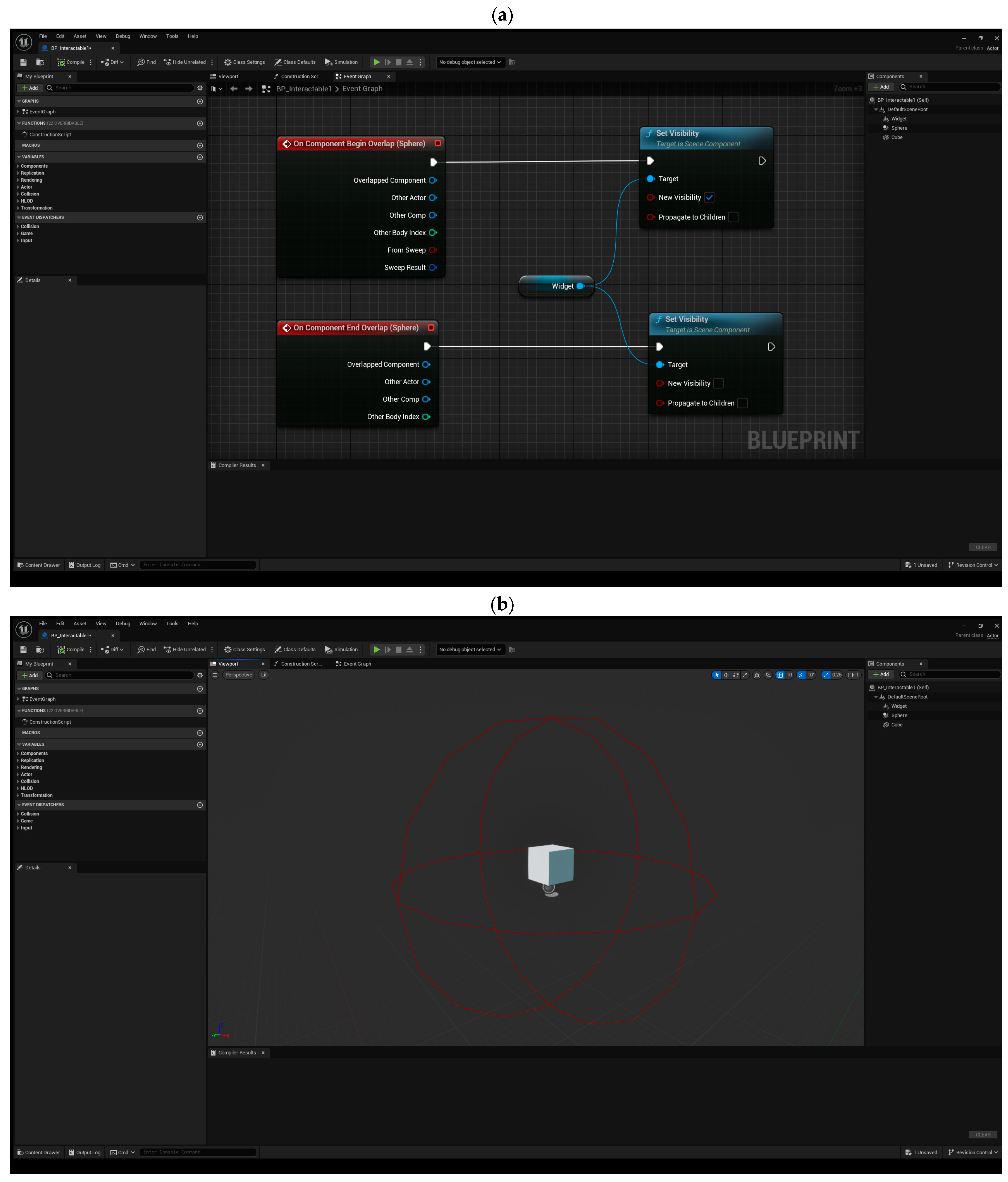
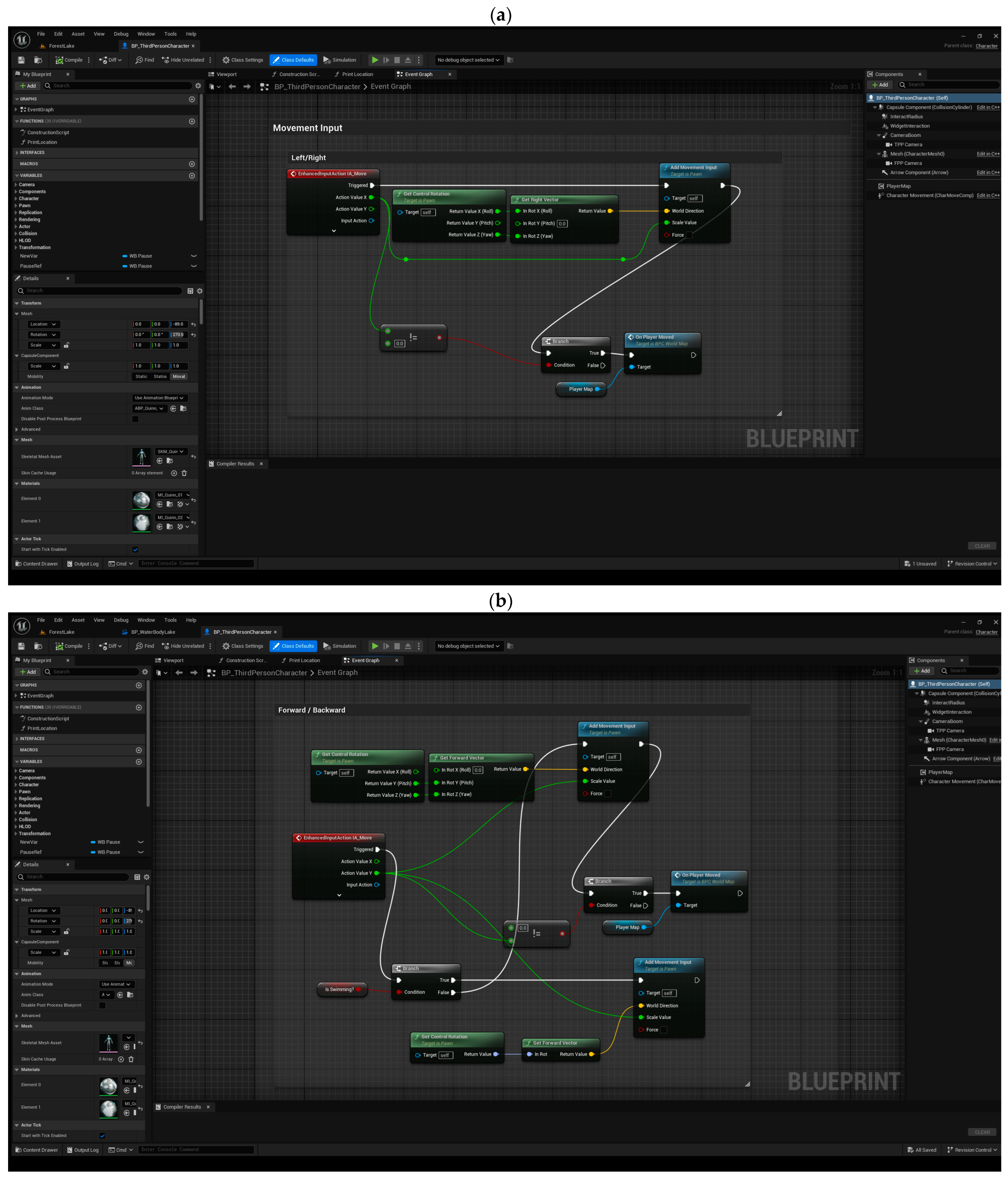
2.2.2. Interactive Features
2.2.3. Photo-Realistic Rendering
2.3. Step 3: Augmenting Data with Static and Dynamic Inputs
2.3.1. Static Data Integration
2.3.2. Dynamic Data Integration
2.3.3. IoT and Real-Time Data Augmentation
2.3.4. Crowdsourcing and Citizen Science
2.3.5. Application of AI and Machine Learning
2.4. Step 4: Simulation and Modeling
2.4.1. Flood Simulation Plugins
2.4.2. Real-Time Modeling
2.5. Hardware Requirements for Creating Immersive Digital Twins in Unreal Engine 5
3. Results and Discussion: Conceptual Implementation and Potential Applications
3.1. Virtual Replica Creation
3.1.1. Challenges and Advances in Topographical Integration with Simulation Engines
3.2. Integration with Game Engines
3.3. Data Augmentation and Real-Time Integration
3.4. Interactive Features and Simulations
3.5. Advanced Tools for Simulating Precipitation and Runoff in Unreal Engine
3.5.1. Niagara System for Precipitation Simulation
Drop Size
Velocity
Direction
Intensity
3.5.2. Chaos Physics for Interaction with Terrain and Objects
Collision Detection
Buoyancy and Surface Water
3.5.3. FluidFlux Plugin for Hydraulic Modeling
Infiltration and Surface Flow
Hydraulic Connectivity
Dynamic Water Levels
3.5.4. Integration with Hydrological Models
Calibration and Validation
Scenario Analysis
3.5.5. Visual Representation and Data Output
3.5.6. Material and Shader Techniques for Water Effects
Reflective and Refractive Materials
Displacement Maps
Wet Surface Effects
3.5.7. Environmental Query System (EQS) for Water Flow Pathfinding
Flow Path Optimization
Flood Risk Assessment
3.5.8. Blueprint Scripting for Dynamic Weather Systems
Weather Events
Time of Day and Seasonal Changes
Adaptive Response Systems
3.5.9. Advanced Fluid Dynamics with Flow Maps
Simulating River and Stream Flow
Erosion and Sediment Transport
3.5.10. Virtual Reality (VR) and Augmented Reality (AR) Integration
Immersive Visualization
Interactive Learning
3.6. Comparisons with Traditional Engineering Software
3.6.1. Comparative Overview of 2D Water Simulation Engines
3.6.2. Comparative Overview of 3D Water Simulation Engines
3.6.3. Comparative Analysis of 3D and 2D Water Simulation Software
3.7. Bridging the Gap between Science and Society
3.7.1. Designing Immersive Experiences for Diverse End-Users
- Political Decision-Makers: They need straightforward, less technical simulation procedures and, most importantly, the ability to test different flooding scenarios in an interactive environment.
- Floodplain Inhabitants: As the main residents of flood-prone areas, they need to get a good sense of flood risk, which requires additional mathematical specifications in immersive platforms while not losing realism and interactivity.
- Basin Authorities: They tend to focus on long-term planning and most definitely need technical details and collaborative support.
- Engineering Students: For educational purposes, simulations should be easy to perform with enough tutorials and available feedback.
- Civil Protection Experts: For emergency applications, simulations should provide more actionable outputs, such as possible evacuation routes, traffic congestion hotspots, and so forth. Additionally, real-time simulation is a key feature for this group.
- Science Communicators: People are involved on the other end of communication; therefore, the simulation should be persuasive, engaging, realistic, interactive, immersive, accessible, easily comprehensible, and, most definitely, visual.
- Step 1: Introduction and Familiarization
- Step 2: Hands-on Experience with the Immersive Digital Twin
- Step 3: Design and Simulation of Hydraulic Structures
- Step 4: Analysis, Feedback, Psychological Impact, and Educational Outcomes
3.7.2. Tailoring Immersive Experiences to Various Flood Types
- Flash floods are mostly characterized by sudden onset and localized impact. Hence, real-time simulation and support of high-resolution DEM should be taken into account during the building of an immersive digital twin with simulation capability.
- Debris flows are a complex matrix of different materials and water. In order to design an accurate immersive experience, the tool should be built upon rigorous physics for simulation of the interaction between water, mud, tree trunks, and boulders. In addition, due attention should be paid to erosional processes and slope stability on steep slopes, which can be conveyed with the support of high-resolution DEM accompanied by soil/lithology data. Different erosion brushes in Unreal Engine and other pre-game development environment creation platforms, such as TerreSculptor, showcase such successful and thoughtful integrations.
- Dam breaks are characterized by a sudden release of an immense volume of water with high energy. The tool should adhere to structural impact analysis and catastrophic failure mechanisms, which have been discernibly designed and modified through the years in Chaos Physics tools embedded in Unreal Engine.
- River plain flooding marks widespread and long-term inundation, which dictates a long duration of computational process and simulation across large areas. Such specification is integrated into game engines through their coverage of large topography data, yet there is room to incorporate more specific simulation tools or amend the existing ones by adding more in-depth options such as soil saturation, agricultural damage analysis, and resilience of the local community and infrastructures.
- Coastal flooding is mostly caused by tides and storm surges and impacts coastal infrastructures. Hence, tide and surge modeling and infrastructure impact analysis should be addressed. Recent fluid simulation plugins in Unreal Engine, most notably FluidFlux, well integrate tidal wave simulation.
- Pluvial flooding caused by intense rainfalls mostly exerts a short-lived impact on urban areas and drainage systems. Such events specify the support of high-resolution 3D maps of urban areas and subsurface and surface water simulation and interaction. Thanks to the recent mutual collaboration between geographic information system companies and game development platforms, most notably Cesium and Unreal Engine, geospatial elements and real-world landscapes (e.g., Google photorealistic 3D tiles) are brought into virtual world creation. The latter can integrate more specific geospatial data, such as urban drainage systems, and, with a decent fluid simulation plugin in a game engine, an immersive experience of simulating and exhibiting a pluvial flood would be possible.
3.8. Integrating Educational, Training, and Psychological Dimensions in Immersive Water Simulations
3.8.1. Educational Environments
3.8.2. Supervised Training
3.8.3. Non-Supervised Training
3.8.4. Psychological Processes in Learning
4. Challenges and Limitations
4.1. Data Quality and Integration
4.2. Technical Complexity
4.3. Educational and Public Outreach
5. Future Works
6. Conclusions
Author Contributions
Funding
Data Availability Statement
Conflicts of Interest
References
- Fineberg, H.V.; Stern, P.C. Understanding Risk: Informing Decisions in a Democratic Society; National Academies Press: Washington, DC, USA, 1996. [Google Scholar]
- Kiker, G.A.; Bridges, T.S.; Varghese, A.; Seager, T.P.; Linkov, I. Application of multicriteria decision analysis in environmental decision making. Integr. Environ. Assess. Manag. Int. J. 2005, 1, 95–108. [Google Scholar] [CrossRef] [PubMed]
- Jiang, H.; Qin, S.; Fu, J.; Zhang, J.; Ding, G. How to model and implement connections between physical and virtual models for digital twin application. J. Manuf. Syst. 2021, 58, 36–51. [Google Scholar] [CrossRef]
- Tao, F.; Qi, Q.; Wang, L.; Nee, A.Y.C. Digital twins and cyber–physical systems toward smart manufacturing and industry 4.0: Correlation and comparison. Engineering 2019, 5, 653–661. [Google Scholar] [CrossRef]
- Tao, F.; Qi, Q.; Liu, A.; Kusiak, A. Data-driven smart manufacturing. J. Manuf. Syst. 2018, 48, 157–169. [Google Scholar] [CrossRef]
- Bakhtiari, V.; Piadeh, F.; Behzadian, K.; Kapelan, Z. A critical review for the application of cutting-edge digital visualisation technologies for effective urban flood risk management. Sustain. Cities Soc. 2023, 99, 104958. [Google Scholar] [CrossRef]
- Bates, P.D.; Neal, J.C.; Alsdorf, D.; Schumann, G.J.P. Observing global surface water flood dynamics. Earth’s Hydrol. Cycle 2014, 35, 839–852. [Google Scholar] [CrossRef]
- Khan, A.; Govil, H.; Khan, H.H.; Thakur, P.K.; Yunus, A.P.; Pani, P. Channel responses to flooding of Ganga River, Bihar India, 2019 using SAR and optical remote sensing. Adv. Space Res. 2022, 69, 1930–1947. [Google Scholar] [CrossRef]
- Khan, S.I.; Hong, Y.; Wang, J.; Yilmaz, K.K.; Gourley, J.J.; Adler, R.F.; Brakenridge, G.R.; Policelli, F.; Habib, S.; Irwin, D. Satellite remote sensing and hydrologic modeling for flood inundation mapping in Lake Victoria basin: Implications for hydrologic prediction in ungauged basins. IEEE Trans. Geosci. Remote Sens. 2010, 49, 85–95. [Google Scholar] [CrossRef]
- Saravi, S.; Kalawsky, R.; Joannou, D.; Rivas Casado, M.; Fu, G.; Meng, F. Use of artificial intelligence to improve resilience and preparedness against adverse flood events. Water 2019, 11, 973. [Google Scholar] [CrossRef]
- Wee, G.; Chang, L.C.; Chang, F.J.; Amin, M.Z. A flood Impact-Based forecasting system by fuzzy inference techniques. J. Hydrol. 2023, 625, 130117. [Google Scholar] [CrossRef]
- Ahmed, I.; Ahmad, M.; Jeon, G.; Chehri, A. An internet of things and ai-powered framework for long-term flood risk evaluation. IEEE Internet Things J. 2023, 11, 3812–3819. [Google Scholar] [CrossRef]
- Alshayeb, M.J.; Hang, H.T.; Shohan, A.A.; Bindajam, A.A. Novel optimized deep learning algorithms and explainable artificial intelligence for storm surge susceptibility modeling and management in a flood-prone island. Nat. Hazards 2024, 120, 5099–5128. [Google Scholar] [CrossRef]
- Ahmad, N.; Yi, X.; Tayyab, M.; Zafar, M.H.; Akhtar, N. Water resource management and flood mitigation: Hybrid decomposition EMD-ANN model study under climate change. Sustain. Water Resour. Manag. 2024, 10, 71. [Google Scholar] [CrossRef]
- Munawar, H.S.; Hammad, A.W.; Waller, S.T. Remote sensing methods for flood prediction: A review. Sensors 2022, 22, 960. [Google Scholar] [CrossRef]
- Moreno, M.; Hernández, W.G. The Business Intelligence Blueprint: Integrating Analytics, Big Data, and Project Management for Organizational Triumph. J. Environ. Sci. Technol. 2024, 3, 161–175. [Google Scholar]
- Kabir, S.; Patidar, S.; Pender, G. A machine learning approach for forecasting and visualising flood inundation information. In Proceedings of the Institution of Civil Engineers-Water Management; Thomas Telford Ltd.: London, UK, 2021; Volume 174, pp. 27–41. [Google Scholar]
- Gao, L.; Zhang, L.; Hong, Y.; Chen, H.X.; Feng, S.J. Flood hazards in urban environment. Georisk Assess. Manag. Risk Eng. Syst. Geohazards 2023, 17, 241–261. [Google Scholar] [CrossRef]
- Ayris, K.; Dixon, E.; Mauchline, A.; Rose, D.C. Investigating stakeholder participation in UK agricultural robotics development. In Proceedings of the First International Symposium on Trustworthy Autonomous Systems, Edinburgh, UK, 11–12 July 2023; pp. 1–5. [Google Scholar]
- Henriksen, H.J.; Roberts, M.J.; van der Keur, P.; Harjanne, A.; Egilson, D.; Alfonso, L. Participatory early warning and monitoring systems: A Nordic framework for web-based flood risk management. Int. J. Disaster Risk Reduct. 2018, 31, 1295–1306. [Google Scholar] [CrossRef]
- Ham, Y.; Kim, J. Participatory sensing and digital twin city: Updating virtual city models for enhanced risk-informed decision-making. J. Manag. Eng. 2020, 36, 04020005. [Google Scholar] [CrossRef]
- Fan, C.; Zhang, C.; Yahja, A.; Mostafavi, A. Disaster City Digital Twin: A vision for integrating artificial and human intelligence for disaster management. Int. J. Inf. Manag. 2021, 56, 102049. [Google Scholar] [CrossRef]
- Purnomo, F.A.; Yoeseph, N.M.; Koesuma, S.; Hartono, R.; Ristania, S.; Riasti, B.K. Virtual Reality Flood Disaster with Variations of Water Levels in the Early Warning System. In Proceedings of the 1st International Conference on Smart Technology, Applied Informatics, and Engineering (APICS), Surakarta, Indonesia, 23–24 August 2022. [Google Scholar]
- Kikuchi, N.A.; Fukuda, T.O.; Yabuki, N.O. How a Flooded City Can Be Visualized from Both the Air and the Ground with the City Digital Twin Approach. System Integration of Flood Simulation and Augmented Reality with Drones. In POST-CARBON, Proceedings of the 27th CAADRIA Conference, Sydney, Australia, 9 April 2022; Association for Computer-Aided Architectural Design Research in Asia (CAADRIA): Hong Kong, 2022. [Google Scholar]
- Song, W. Development of a Digital Twin-Based Early Warning System for River Flooding: A Case Study of the Tartano River. Master’s Thesis, Polytechnic University of Milan, Milan, Italy, 2023. [Google Scholar]
- Riaz, K.; McAfee, M.; Gharbia, S.S. Management of climate resilience: Exploring the potential of digital twin technology, 3D city modelling, and early warning systems. Sensors 2023, 23, 2659. [Google Scholar] [CrossRef]
- Morales Ortega, L.R. A Digital Twin for Ground Water Table Monitoring. Master’s Thesis, University of Twente, Enschede, The Netherland, 2023. [Google Scholar]
- Ariyachandra, M.M.; Wedawatta, G. Digital twin smart cities for disaster risk management: A review of evolving concepts. Sustainability 2023, 15, 11910. [Google Scholar] [CrossRef]
- Roudbari, N.S.; Punekar, S.R.; Patterson, Z.; Eicker, U.; Poullis, C. From data to action in flood forecasting leveraging graph neural networks and digital twin visualization. Sci. Rep. 2024, 14, 18571. [Google Scholar] [CrossRef]
- Rajendran, S. Development of Digital Twin Framework for Decision Support in Flood Risk Management. Master’s Thesis, University of Twente, Enschede, The Netherland, 2024. [Google Scholar]
- Chen, H.; Xiao, X.; Chen, C.; Chen, M.; Li, C.; Lu, K.; Lin, H.; Fang, C. Digital twin-based virtual modeling of the Poyang Lake wetland landscapes. Environ. Model. Softw. 2024, 181, 106168. [Google Scholar] [CrossRef]
- Wortley, D.J. Digital Twins and Disaster Risk Reduction. In Proceedings of the 9th International Conference on Cartography and GIS, Nessebar, Bulgaria, 16–21 June 2024. [Google Scholar]
- Hyun, C.T.; Lee, S.; Jin, C. Digital Twin for Disaster Management in Smart City. In Advances in Information and Communication, Proceedings of the 2024 Future of Information and Communication Conference, Berlin, Germany, 4–5 April 2024; Springer: Cham, Switzerland, 2024. [Google Scholar]
- Nex, F.; Remondino, F. UAV for 3D mapping applications: A review. Appl. Geomat. 2014, 6, 1–15. [Google Scholar] [CrossRef]
- Luhmann, T.; Robson, S.; Kyle, S.; Boehm, J. Close-Range Photogrammetry and 3D Imaging; Walter de Gruyter GmbH & Co KG.: Berlin, Germany, 2023. [Google Scholar]
- Hillemann, M.; Langendörfer, R.; Heiken, M.; Mehltretter, M.; Schenk, A.; Weinmann, M.; Hinz, S.; Heipke, C.; Ulrich, M. Novel View Synthesis with Neural Radiance Fields for Industrial Robot Applications. arXiv 2024, arXiv:2405.04345. [Google Scholar] [CrossRef]
- Nwilag, B.D.; Eyoh, A.E.; Ndehedehe, C.E. Digital toographic mapping and modelling using low altitude unmanned aerial vehicle. Model. Earth Syst. Environ. 2023, 9, 1463–1476. [Google Scholar] [CrossRef]
- Levy, J.; Liu, D. Extended Reality (XR) Environments for Flood Risk Management with 3D GIS and Open Source 3D Graphics Cross-Platform Game Engines: Advances in Immersive Sea Level Rise Planning Technologies for Student Learning and Community Engagement. In Proceedings of the 7th ASRES International Conference on Intelligent Technologies (ICIT 2022), Jakarta, Indonesia, 16–18 December 2022; Lecture Notes in Networks and Systems. Arya, K.V., Tripathi, V.K., Rodriguez, C., Yusuf, E., Eds.; Springer: Singapore, 2023; Volume 685. [Google Scholar] [CrossRef]
- Worgan, J. Real-Time Multiple Fluid Simulation for Games. Master’s Thesis, University of Bournemouth, Bournemouth, UK, 2022. [Google Scholar]
- McBurnett, L.R.; Hinrichs, M.M.; Seager, T.P.; Clark, S.S. Simulation gaming can strengthen experiential education in complex infrastructure systems. Simul. Gaming 2022, 49, 620–641. [Google Scholar] [CrossRef]
- Nijhawan, S.; Yashima, T.; Kojima, T. 3DFlowRenderer: One-shot Face Re-enactment via Dense 3D Facial Flow Estimation. arXiv 2024, arXiv:2404.14667. [Google Scholar]
- Jiang, W.; Zhan, Y.; Xiao, X.; Sha, G. Network Simulators for Satellite-Terrestrial Integrated Networks: A Survey. IEEE Access 2023, 11, 98269–98292. [Google Scholar] [CrossRef]
- Zhang, Y.; Li, J.; Duan, M.; Chen, W.; del Rio, J.; Zhang, X.; Wang, K.; Liang, S.H.; Chen, Z.; Chen, N.; et al. Multi-sensor integration management in the earth observation sensor web: State-of-the-art and research challenges. Int. J. Appl. Earth Obs. Geoinf. 2023, 125, 103601. [Google Scholar] [CrossRef]
- Heipke, C. Crowdsourcing geospatial data. ISPRS J. Photogramm. Remote Sens. 2010, 65, 550–557. [Google Scholar] [CrossRef]
- Chen, J.; Remulla, D.; Nguyen, J.H.; Dua, A.; Liu, Y.; Dasgupta, P.; Hung, A.J. Current status of artificial intelligence applications in urology and their potential to influence clinical practice. BJU Int. 2019, 124, 567–577. [Google Scholar] [CrossRef] [PubMed]
- Andrade, M.V.P.D. A Data Collecting Framework for Human Reliability Analysis via Game Engine Based Simulators. Master’s Thesis, Universidade Federal de Pernambuco, Recife, Brazil, 2018. [Google Scholar]
- Zhou, Z. Immersive Computing for Coastal Engineering. Ph.D. Thesis, University of Southern California, Los Angeles, CA, USA, 2022. [Google Scholar]
- Ghaith, M.; Yosri, A.; El-Dakhakhni, W. Synchronization-enhanced deep learning early flood risk predictions: The core of data-driven city digital twins for climate resilience planning. Water 2022, 14, 3619. [Google Scholar] [CrossRef]
- Gazetdinov, D. Application of Virtual Reality Technology in the Marketing of Companies. Master’s Thesis, Czech Technical University in Prague, Masaryk Institute of Higher Studies, Praha, Czech Republic, 2023. [Google Scholar]
- Satalin, A. Improving the game development process on Unreal Engine 5. Bachelor’s Thesis, Häme University of Applied Sciences, Hämeenlinna, Finland, 2024. [Google Scholar]
- Moore, I.D.; Grayson, R.B.; Ladson, A.R. Digital terrain modelling: A review of hydrological, geomorphological, and biological applications. Hydrol. Process. 1991, 5, 3–30. [Google Scholar] [CrossRef]
- Falcão, A.P.; Matias, M.P.; Pestana, R.; Gonçalves, A.B.; Heleno, S. Methodology to combine topography and bathymetry data sets for hydrodynamic simulations: Case of Tagus River. J. Surv. Eng. 2016, 142, 05016005. [Google Scholar] [CrossRef]
- Banks, J.C.; Camp, J.V.; Abkowitz, M.D. Adaptation planning for floods: A review of available tools. Nat. Hazards 2014, 70, 1327–1337. [Google Scholar] [CrossRef]
- Venier, C.M.; Reyes Urrutia, A.; Capossio, J.P.; Baeyens, J.; Mazza, G. Comparing ANSYS Fluent® and OpenFOAM® simulations of Geldart A, B and D bubbling fluidized bed hydrodynamics. Int. J. Numer. Methods Heat Fluid Flow 2020, 30, 93–118. [Google Scholar] [CrossRef]
- Mezirow, J. Transformative learning: Theory to practice. New Dir. Adult Contin. Educ. 1997, 1997, 5–12. [Google Scholar] [CrossRef]
- Reed, M.S. Stakeholder participation for environmental management: A literature review. Biol. Conserv. 2008, 141, 2417–2431. [Google Scholar] [CrossRef]
- Gee, J.P. What video games have to teach us about learning and literacy. Comput. Entertain. (CIE) 2003, 1, 20. [Google Scholar] [CrossRef]
- Meyer, V.; Kuhlicke, C.; Luther, J.; Fuchs, S.; Priest, S.; Dorner, W.; Serrhini, K.; Pardoe, J.; McCarthy, S.; Seidel, J.; et al. Recommendations for the user-specific enhancement of flood maps. Nat. Hazards Earth Syst. Sci. 2012, 12, 1701–1716. [Google Scholar] [CrossRef]
- Mohanty, M.P.; Karmakar, S. WebFRIS: An efficient web-based decision support tool to disseminate end-to-end risk information for flood management. J. Environ. Manag. 2021, 288, 112456. [Google Scholar] [CrossRef]
- Leal, M.; Ramos, C.; Pereira, S. Different types of flooding lead to different human and material damages: The case of the Lisbon Metropolitan Area. Nat. Hazards 2018, 91, 735–758. [Google Scholar] [CrossRef]
- Alon, Y.; Azriel, O.; Pine, D.S.; Bar-Haim, Y. A randomized controlled trial of supervised remotely-delivered attention bias modification for posttraumatic stress disorder. Psychol. Med. 2023, 53, 3601–3610. [Google Scholar] [CrossRef]
- Stara, V.; Rampioni, M.; Moșoi, A.A.; Kristaly, D.M.; Moraru, S.A.; Paciaroni, L.; Paolini, S.; Raccichini, A.; Felici, E.; Cucchieri, G.; et al. The impact of a multicomponent platform intervention on the daily lives of older adults. Healthcare 2023, 11, 3102. [Google Scholar] [CrossRef] [PubMed]









| Hardware | Minimum (Budget) Build | Recommended (Best) Build |
|---|---|---|
| Central Processing Unit (CPU) | Intel 1 Core i7-14700K or AMD 2 Ryzen 7 7800X | Intel’s Core i9 13900K and 14900K or AMD’s Threadripper 7000 series |
| Graphical Processing Unit (GPU) | NVIDIA RTX 2070 SUPER or AMD RX 6600 XT | NVIDIA 3 RTX 4080 or 4090 |
| Random-Access Memory (RAM) | 16 GB–32 GB | 64 GB–128 GB |
| Storage | 500 GB SSD | 1TB NVMe 4 SSD |
Disclaimer/Publisher’s Note: The statements, opinions and data contained in all publications are solely those of the individual author(s) and contributor(s) and not of MDPI and/or the editor(s). MDPI and/or the editor(s) disclaim responsibility for any injury to people or property resulting from any ideas, methods, instructions or products referred to in the content. |
© 2024 by the authors. Licensee MDPI, Basel, Switzerland. This article is an open access article distributed under the terms and conditions of the Creative Commons Attribution (CC BY) license (https://creativecommons.org/licenses/by/4.0/).
Share and Cite
Yin, W.; Hu, Q.; Liu, W.; Liu, J.; He, P.; Zhu, D.; Kornejady, A. Harnessing Game Engines and Digital Twins: Advancing Flood Education, Data Visualization, and Interactive Monitoring for Enhanced Hydrological Understanding. Water 2024, 16, 2528. https://doi.org/10.3390/w16172528
Yin W, Hu Q, Liu W, Liu J, He P, Zhu D, Kornejady A. Harnessing Game Engines and Digital Twins: Advancing Flood Education, Data Visualization, and Interactive Monitoring for Enhanced Hydrological Understanding. Water. 2024; 16(17):2528. https://doi.org/10.3390/w16172528
Chicago/Turabian StyleYin, Weibo, Qingfeng Hu, Wenkai Liu, Jinping Liu, Peipei He, Dantong Zhu, and Aiding Kornejady. 2024. "Harnessing Game Engines and Digital Twins: Advancing Flood Education, Data Visualization, and Interactive Monitoring for Enhanced Hydrological Understanding" Water 16, no. 17: 2528. https://doi.org/10.3390/w16172528
APA StyleYin, W., Hu, Q., Liu, W., Liu, J., He, P., Zhu, D., & Kornejady, A. (2024). Harnessing Game Engines and Digital Twins: Advancing Flood Education, Data Visualization, and Interactive Monitoring for Enhanced Hydrological Understanding. Water, 16(17), 2528. https://doi.org/10.3390/w16172528


