Highlights
- This is a novel approach to flood prediction based on a coupled deep learning algorithm.
- The approach can be used to predict the dynamic evolution of floods.
- The proposed approach is shown to be fast, efficient, and precise.
- The flood diversion pipeline has a remarkable effect in reducing urban waterlogging.
Abstract
In recent years, urban waterlogging disasters have become increasingly prominent. Physically based urban waterlogging simulation models require considerable computational time. Therefore, rapid and accurate simulation and prediction of urban pluvial floods are important for disaster prevention and mitigation. For this purpose, we explored an urban waterlogging prediction method based on a long short-term memory neural network model that integrates an attention mechanism and a 1D convolutional neural network (1DCNN–LSTM–Attention), using the diversion of the Jinshui River in Zhengzhou, China, as a case study. In this method, the 1DCNN is responsible for extracting features from monitoring data, the LSTM is capable of learning from time-series data more effectively, and the Attention mechanism highlights the impact of features on input effectiveness. The results indicated the following: (1) The urban waterlogging rapid prediction model exhibited good accuracy. The Pearson correlation coefficient exceeded 0.95. It was 50–100 times faster than the InfoWorks ICM model. (2) Diversion pipelines can meet the design flood standard of a 200-year return period, aligning with the expected engineering objectives. (3) River channel diversion significantly reduced the extent of inundation. Under the 30-year return period rainfall scenario, the maximum inundation area decreased by 1.46 km2, approximately equivalent to 205 international standard soccer fields.
1. Introduction
In recent years, urban waterlogging disasters have become increasingly prominent due to the rapid advancement of global climate change and urbanization [,,,]. Intense rainfall events have led to urban river channel overflows, exacerbating the challenges associated with coping with urban waterlogging disasters and posing significant threats to people’s lives, property, and urban infrastructure. For example, in February 2023, São Paulo, Brazil, was hit by heavy rainfall, which resulted in river flooding, severe flooding, collapsed houses, and hindered transportation across the city []. In July 2023, Beijing, China, experienced severe waterlogging disasters, with the water level of the Yongding River sharply rising and the collapse of the Xiaoqing River Bridge, causing extensive damage and sweeping away numerous vehicles [,]. Therefore, developing effective urban flood control and disaster reduction measures has become an urgent priority in urban planning and water resource engineering.
To effectively address this challenge, some scholars have conducted in-depth research on measures to mitigate waterlogging disasters. Firstly, sponge cities represent an important engineering measure of reducing urban waterlogging disasters [,,,]. Facilities associated with sponge city construction perform functions such as infiltration, retention, storage, and purification. By increasing rainwater infiltration and reducing surface runoff, sponge cities can decrease the risk of waterlogging, thereby having considerable research and practical significance in sustainable urban ecological development. Secondly, embankment construction is a crucial engineering measure for addressing river problems, playing a role in improving the ecological environment of rivers and enhancing flood control and drainage capabilities [,,]. Additionally, non-engineering measures have emerged for urban flood control and disaster reduction, such as improving emergency management systems, establishing flood forecasting and warning systems, and strengthening flood disaster management [,,,]. These non-engineering measures play a role in reducing losses from urban waterlogging. The aforementioned measures are highly important for pre-warning, rescue during disasters, and post-disaster reconstruction of urban waterlogged areas. However, they may not effectively solve problems such as river channel overflow and other waterlogging issues (e.g., the toppling of inlet pipes into rivers).
The increase in impervious surfaces in cities accelerates the runoff yield and concentration in urban areas; therefore, the problem of river channel overflow triggered by heavy rainfall is often accompanied by deeper water accumulation, wider inundation areas, and faster flood flow velocities, leading to a shorter formation time for urban floods [,,,]. Constructing an urban waterlogging warning model is an effective measure for reducing losses from waterlogging disasters. Against the background of increasing impermeable surfaces in urban areas, a warning model is required to achieve both rapid prediction speed and good prediction accuracy [,,]. Given the concentration of populations in urban areas (such as the population on both sides of the Jinshui River in the study area), untimely or inaccurate warnings of waterlogging disasters may lead to severe property damage and casualties. Therefore, the demand for rapid and accurate prediction of urban floods is becoming increasingly urgent.
Currently, most studies on urban flood prediction rely on physically based flood simulation models such as MIKE Urban, InfoWorks ICM, and MOUSE [,,,]. Although these models can couple conduit flow and surface runoff simulations and demonstrate good simulation accuracy, they face the challenge of prolonged simulation times, especially for large simulation areas. Therefore, physically based flood simulation models are not suitable for meeting the demand for rapid prediction, particularly in urban riverbank overflow warning systems. In recent years, scholars have utilized artificial intelligence algorithms to learn the relationship between inputs and outputs to efficiently and accurately predict urban floods, thereby meeting the demand for flood prediction. This approach shortens the simulation time and ensures high prediction accuracy. For example, Kao et al. employed long short-term memory (LSTM) neural networks to construct a rapid flood inundation prediction model, achieving rapid prediction of inundation depth at a resolution of 40 m, with R2 values exceeding 0.95 [] (Kao et al. 2021). Xie et al. constructed 14,278 ANN models involving deep learning techniques, achieving fast prediction of inundation depth for each grid cell within study areas of 7.9 km2 []. Chen et al. combined hydrodynamic models with machine-learning algorithms and proposed a rapid urban inundation prediction method []. Despite the promising results achieved using artificial intelligence in flood inundation prediction, most studies have focused on predicting the maximum flood inundation depth rather than its dynamic evolution process.
In conclusion, urban riverbank overflow exacerbates urban waterlogging disasters. To achieve rapid and accurate prediction of waterlogging disasters and reduce the losses caused by urban riverbank overflow, two aspects need to be considered: firstly, effective measures to reduce riverbank overflow problems should be implemented, which can mitigate riverbank overflow issues and alleviate internal waterlogging problems such as conduit toppling; secondly, methods for rapid and accurate prediction of urban waterlogging disasters are required, which should possess both swift prediction speed and good prediction accuracy.
Urban river channel flood diversion is a common urban flood control measure that disperses rainfall and reduces runoff velocity, thereby lowering peak water levels and mitigating the risk of urban waterlogging disasters [,]. To this end, this study took the diversion pipeline project of the Jinshui River in Zhengzhou, China, as an example and employed hydrodynamic models and artificial intelligence algorithms to investigate the mitigation effect of urban river channel flood diversion on waterlogging disasters. First, an urban waterlogging simulation model was constructed within the diversion pipeline construction area using InfoWorks ICM 2023.0, and a storm-flooding dataset was established based on the design rainfall data and simulation results from the InfoWorks ICM model. Second, a rapid urban waterlogging prediction model was developed by integrating 1D convolutional neural network (1DCNN), LSTM, and Attention mechanism algorithms and was trained using the storm-flooding dataset. Finally, the mitigation effect of urban river channel flood diversion on waterlogging disasters was explored, focusing on the drainage capacity of pipelines and the characteristics of waterlogging submergence. This study aimed to provide scientific references and feasible suggestions for urban waterlogging prevention and control.
2. Study Area and Data
2.1. Study Area
Zhengzhou is located in the southern part of the North China Plain, downstream of the Yellow River, in the central-northern part of Henan Province, China. It has a temperate monsoon climate with four distinct seasons. The average annual precipitation is 632 mm, with rainfall concentrated from June to September accounting for approximately 60% of the annual precipitation [,]. The central urban area of Zhengzhou consists of Zhongyuan District, Erqi District, Guancheng Hui Autonomous District, Jinshui District, and Huiji District. The Jinshui River is the main river in the central urban area of Zhengzhou and is a major tributary of the Jialu River. Flowing from southwest to northeast through Erqi District, Zhongyuan District, Jinshui District, and Zhengdong New District, Jinshui River has a total length of 27.66 km and a drainage area of 80.1 km2. It is one of the main flood drainage channels in the central urban area and the only urban river connecting the four main urban districts of Zhengzhou, making it a crucial flood control target.
The main construction components of the Jinshui River flood diversion project include the flood diversion pipeline project, flood diversion outlet project, and Jialu River channel regulation project. This study focused on the construction area of the Jinshui River flood diversion pipeline project as the study area (Figure 1). The study area included both the Jinshui River and Jialu River. The banks of the Jialu River were mainly covered with bare soil or farmland, whereas those of the Jinshui River were predominantly occupied by buildings with high population and housing density, making them prone to rainstorm-induced waterlogging disasters. The Jinshui River flood diversion pipeline project diverts floodwater from Jinshui River to Jialu River through drainage pipelines. The flood diversion pipeline project includes pipeline inlet works, manholes, and receiving well works. The total length of the flood diversion pipeline is 5.405 km, with a flow capacity of 75 m3/s. A top-down construction method was adopted using two parallel DN4000 prestressed concrete pipes placed 6 m apart. Along the pipeline route, eight manholes and seven receiving wells were set up, all of which were constructed using circularly reinforced concrete sink structures. The terrain of the study area was relatively flat, with ground elevations ranging from 107.5 to 162.8 m above the Yellow Sea datum.
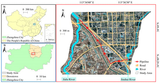
Figure 1.
Study area overview nap (“Pipeline” refers to the flood diversion pipeline).
2.2. Data Sources
(1) Drainage network data: Sourced from the “Drainage Engineering Plan of Zhengzhou City (2011–2020)” and field survey data. The pipeline cross-section shapes were classified as rectangular or circular, with rectangular pipelines ranging from a minimum size of 900 mm × 700 mm to a maximum of 1800 mm × 2000 mm, and the circular pipelines ranged from a minimum diameter of 800 mm to a maximum of 2400 mm. Data for flood diversion pipelines were derived from the “Design General Instructions for Construction Drawings of the Jinshui River Flood Diversion Project in Zhengzhou City” and are shown in Figure 2a.
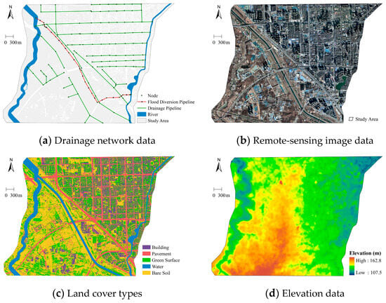
Figure 2.
Basic data of the study area.
(2) Remote sensing image data: Remote sensing imagery (from 2023) was sourced from China Siwei Geo-Information Technology Co., Ltd. with a resolution of 0.49 m, as shown in Figure 2b. Using a combination of maximum likelihood classification and manual correction in ArcGIS, land cover types on the ground were derived from the remote sensing imagery, as illustrated in Figure 2c.
(3) Elevation data: Topographic data (from 2023) were obtained from China Siwei Geo-Information Technology Co., Ltd. with an accuracy of 12.5 m. After fine processing the buildings and road networks, the data were utilized for model construction. The elevation range in the study area spanned 107.5–162.8 m (Yellow Sea datum), as depicted in Figure 2d.
(4) River data: The study area comprised two main rivers, the Jinshui River and Jialu River, which receive water discharge from the basin. River data included information on river topography, cross-sections, riverbanks, and water levels, sourced from the “Engineering Geological Survey Report of the Zhengzhou Jinshui River Diversion Project”.
(5) Rainfall data: Observed rainfall data were sourced from a meteorological station in Zhengzhou City, covering the period of 2011–2023. Data on the actual inundation points for model validation were obtained from field surveys and relevant news reports. The design rainfall sequences were derived from the design rainfall intensity formula for Zhengzhou City published by the Zhengzhou Natural Resources and Planning Bureau in 2023. The time interval was set to 5 min, rainfall coefficient was 0.4, and total duration was 120 min. The formula used is as follows:
where i represents the rainfall intensity (mm/h), P represents the return period of the design rainfall (yr), and t represents the total duration of the design rainfall (min).
3. Methodology
3.1. Research Framework
Urban waterlogging disasters have become increasingly prevalent in recent years. Fast and accurate simulations and predictions of urban pluvial floods are important for disaster prevention and mitigation. To address this, we explored a city waterlogging prediction method based on 1DCNN–LSTM–Attention, using the example of the Jinshui River diversion project in Zhengzhou, China. We employed methods such as the InfoWorks ICM and deep-learning models to investigate the mitigation effect of urban river diversion on waterlogging disasters, focusing on two aspects: the drainage capacity of pipelines and the characteristics of inundation caused by waterlogging. The technical roadmap is illustrated in Figure 3, and the specific research contents are as follows:
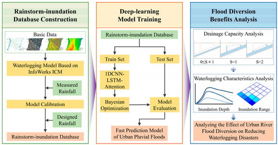
Figure 3.
Technical route of this study.
(1) Construction of a heavy rainfall inundation dataset: Owing to the limited measured rainfall inundation data, we utilized simulation data from the InfoWorks ICM model as the dataset for the deep-learning model. First, based on fundamental data (such as those on the drainage pipe network, remote sensing imagery, land cover types, ground elevation, and river cross-sections), a simulation model for heavy rainfall inundation in the study area was constructed using the InfoWorks ICM model, which was then calibrated using measured rainfall-inundation data from Zhengzhou. Second, 120 rainfall scenarios comprising six common rainfall patterns in Zhengzhou combined with 20 return periods were input into the InfoWorks ICM model to simulate the water depth for each triangular mesh. Finally, a heavy rainfall inundation dataset was constructed based on the design rainfall data and simulated results from the InfoWorks ICM model.
(2) Training of the deep-learning model: This study integrated the 1DCNN, LSTM, and Attention algorithms to construct a fast urban waterlogging prediction model. The 1DCNN was responsible for feature extraction from the monitoring data, the LSTM was effective in learning from time-series data, and the Attention mechanism highlighted the influence of features on the input effects, thus improving computational speed without affecting the accuracy of the model and further enhancing the prediction accuracy and stability of the model. First, the heavy rainfall-inundation dataset was randomly divided into training and test sets at a ratio of 4:1. Second, to eliminate the influence of different dimensions, the data were normalized using the min–max scaling method. Finally, the accuracy of the model was verified based on the measured and predicted values of the water depth, thereby obtaining a fast urban waterlogging prediction model based on 1DCNN–LSTM–Attention.
(3) Benefit analysis of diversion projects: This study investigated the mitigation effects of urban river diversions on waterlogging disasters by focusing on the drainage capacity of pipelines and their inundation characteristics. First, using the maximum values from the InfoWorks ICM simulation results as the evaluation index, the impact of urban river diversion on the drainage capacity of the pipe network was analyzed based on the overloaded state of the pipelines. Finally, based on the prediction results of the 1DCNN–LSTM–Attention model, the influence of urban river diversion on the inundation characteristics, including water depth and inundation area, was analyzed.
3.2. Rainstorm Inundation Database
As rainstorm inundation data is in spatiotemporal form, involving a large number of grids, it is realistically difficult to obtain through manual measurements and monitoring instruments. InfoWorks Integrated Catchment Modeling (ICM) is an advanced, integrated catchment modeling software with cloud capabilities that models complex hydraulic and hydrologic network elements quickly and accurately in a collaborative environment. InfoWorks ICM provides modules for rainfall runoff, network flow, and 2D surface water flood modelling. Surface runoff processes include various runoff models, such as Horton, as well as SCS and routing models such as SWMM and SCS Unit [,,]. The urban flooding process can be finely simulated using the InfoWorks ICM model. At the same time, the simulation results of urban flooding can provide training samples for deep-learning models.
In a 1D network flow simulation, the complete Saint-Venant equations were solved; the equations included equations for mass conservation and momentum conservation, as follows:
where A represents the cross-sectional area (m2), Q denotes the flow rate (m3/s), g denotes the acceleration due to gravity (m2/s), θ represents the angle between the pipe centerline and the horizontal line (°), K indicates the hydraulic conductivity, and S0 represents the slope of the channel bed.
In the 1D river channel flow simulations, the river channel was simplified into an open channel conduit, and a 1D hydrodynamic model was employed for the simulation. The expressions are as follows:
where Q represents discharge (m3/s), A denotes the cross-sectional area of the river channel for water passage (m2), t stands for time (s), x represents the horizontal coordinate along the water flow direction (m), y indicates the water level (m), g represents the gravitational acceleration (m2/s), β is the momentum correction coefficient (°), K denotes the discharge coefficient determined using the Manning formula, Sf represents the frictional slope, u signifies the velocity of lateral inflow into the river channel in the direction of the channel (m/s), and q denotes the lateral inflow rate into the river channel (m3/s).
In a 2D surface runoff simulation, shallow-water equations, also known as the depth-averaged form of the Navier–Stokes equations, were employed to mathematically describe the 2D flow regime. It was assumed that the flow primarily occurred in the horizontal direction, and variations in flow velocity in the vertical direction were ignored. The shallow-water equations are expressed as follows:
where h represents the water depth (m), u and v represent the velocities in the x and y directions, respectively (m/s), S0,x and S0,y represent the bed slopes in the x and y directions, respectively, Sf,x and Sf,y represent the frictional forces in the x and y directions, respectively, q1D denotes the discharge per unit area (m3/s), and u1D and v1D represent the velocities of q1D in the x and y directions, respectively (m/s).
Next, 120 rainfall scenarios comprising six common rainfall patterns in Zhengzhou (Figure 4) combined with 20 return periods (1, 2, 3, 4, 5, 7, 10, 20, 30, 40, 50, 70, 100, 200, 300, 400, 500, 700, 800, and 1000a) were input into the InfoWorks ICM model to simulate the water depth for each triangular mesh. Finally, a heavy rainfall inundation dataset was constructed based on the design rainfall data and simulated results from the InfoWorks ICM model.
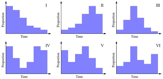
Figure 4.
Six common rainfall patterns in Zhengzhou (I, II and III are unimodal rainfall. IV, V and VI are bimodal rainfall).
3.3. Deep-Learning Models
Neural networks are computational models that simulate interconnected networks of neurons in the human brain, comprising a large number of nodes [,]. Each connection between neurons can transmit signals to another neuron, and after processing, neurons can relay signals to the next level of neurons. Neurons adjust their signal transmission thresholds by learning to achieve effects similar to those of real models. Neural networks are composed of neurons, whose structure is depicted in Figure 5. Below are brief introductions to the 1DCNN algorithm, LSTM algorithm, and Attention mechanism.
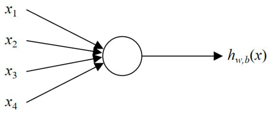
Figure 5.
Neuron structure diagram.
The output of a neuron is represented by the following equation:
where the function f(x) represents the activation function.
3.3.1. 1DCNN
The CNN model possesses powerful spatial grid data processing capabilities, enabling automatic extraction of target features without relying on predefined feature descriptions. CNN models include 1D, 2D, and 3D variants, with 2D and 3D CNNs being commonly used for image and video processing []. In this study, the input rainfall features for flood prediction were 1D data; hence, a 1D CNN model was adopted. In a 1D CNN, the output from the preceding 1D convolution layer is propagated forward to serve as input to the neurons in the subsequent layer.
where represents the input to the k-th neuron of the l-th convolutional layer, is the bias of the k-th neuron in the l-th convolutional layer, denotes the output of the i-th neuron in the (l−1)-th convolutional layer, represents the convolution kernel from the i-th neuron in the (l−1)-th convolutional layer to the k-th neuron in the l-th convolutional layer, and Conv1D represents the 1D convolution operation.
3.3.2. LSTM
A recurrent neural network (RNN) is a type of neural network specifically designed to model sequential data. The RNN unit passes its own state in the direction of the sequence progression and connects according to a chain-like structure. An LSTM network is an improvement compared to the RNN model. Owing to the vanishing gradient problem, the RNN model only has short-term memory and cannot continue to improve model accuracy. LSTM introduces memory units and gate structures based on an RNN. It captures long-term dependency information in time-series data by retaining or discarding information during transmission. The three gates added by the LSTM network are the forget, input, and output gates []. The unit structure of the LSTM network model is shown in Figure 6.
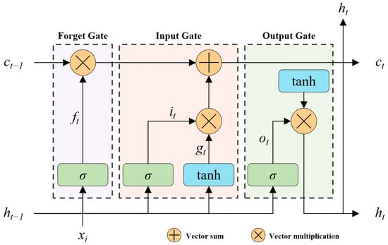
Figure 6.
Basic structure of the LSTM cell unit.
The updated equations for the LSTM layer are as follows:
where xt is the input data at time t, V and W are weight matrices, h is the number of hidden units, b is the linear bias of the fully connected layer, σ is the sigmoid activation function, and it, ft, ct, and ot are the input gate, forget gate, cell state, and output gate, respectively.
3.3.3. Attention
The attention mechanism draws inspiration from the process by which human senses receive information. When facing a scene, reading text, or listening to an audio, the brain autonomously adjusts its attention to different aspects, focusing on areas of interest to efficiently receive and process information. This introduced an attention mechanism into an LSTM network. Unlike a regular fully connected layer, an attention mechanism layer can determine the weights of the outputs at each time step based on the input rather than using fixed coefficients. The attention mechanism dynamically allocates different attention weights to each part, obtaining information that is more relevant to the current task objective []. The attention processes were calculated as follows.
where xt represents an element of the input sequence at time step t, Dense denotes a fully connected layer, W represents the weight matrix, and b represents the bias term.
3.4. Model Construction and Evaluation
3.4.1. Construction and Evaluation of Urban Waterlogging Simulation Model
The permeable surfaces in the study area included green areas and bare soil, for which the Horton formula was selected as the infiltration model. Impermeable surfaces included buildings, pavements, and water bodies, and runoff was calculated using the fixed-runoff coefficient method. The drainage system in the study area comprised two rivers, 133 drainage pipes, 132 rainwater wells, and three outlets. Initially, the study area was divided into 117 sub-watersheds using a combination of the Thiessen polygon method and manual adjustments based on the positions of the rainwater wells and street distribution. Subsequently, a terrain model was created using the elevation data, and the 2D calculation area of the study area was divided into grids. Additionally, the elevations of buildings and road grid cells were increased by 5 m and decreased by 0.15 m, respectively, to reflect their roles in blocking and guiding floodwaters. Finally, a 1D river model was established, and the rainfall type was modified to 2D to facilitate the coupled simulation of the 1D pipe network runoff, 1D river runoff, and 2D surface runoff.
Four recorded rainfall events (Table 1) were selected for the calibration and validation of the model parameters. For parameter calibration, both the traditional manual trial-and-error method and the comprehensive runoff coefficient method were employed. The comprehensive runoff coefficients obtained for the rainfall events on 15 May 2018, 1 August 2018, and 20 September 2021 were 0.622, 0.653, and 0.681, respectively, which are close to the comprehensive runoff coefficient of 0.65 specified in the “Drainage Engineering Plan of Zhengzhou City (2011–2020)”. For parameter validation, the simulation of the rainfall event on 20 July 2021 revealed that the observed waterlogging locations corresponded well with the simulated locations (Figure 7), and the water depths at the main waterlogging points were consistent (Table 2). Therefore, the model was considered reliable.

Table 1.
Actual rainfall data in Zhengzhou City.
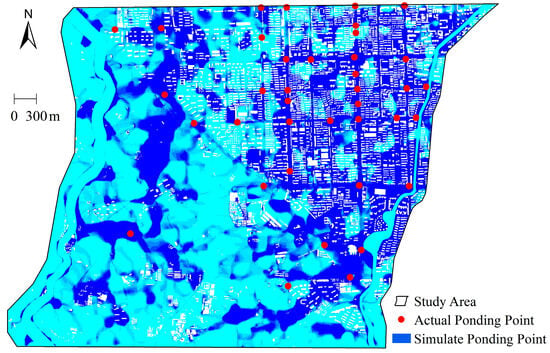
Figure 7.
Comparison between simulated and measured water accumulation points.

Table 2.
Comparison between simulated rainfall and measured waterlogging depth for 20,210,720 rainfall events.
3.4.2. Construction of Urban Waterlogging Prediction Model
This study adopted an algorithm that integrates 1DCNN, LSTM, and Attention to construct a model for urban waterlogging prediction, as illustrated in Figure 8. The 1DCNN was employed for feature extraction from the data, the LSTM was utilized for handling and predicting time-series-related data, and the Attention mechanism dynamically assigned different attention weights to each part to obtain information that was more relevant to the current task objective.

Figure 8.
Model structure based on 1DCNN–LSTM–Attention (“1DCNN” stands for 1D convolutional neural network, “LSTM” stands for long short-term memory neural network, “Attention” stands for attention mechanism).
The training steps for the urban inundation prediction model based on 1DCNN–LSTM–Attention are as follows:
(1) Dataset construction: Because of the limited measured rainfall runoff data, simulated data from InfoWorks ICM were used. This involved inputting 120 rainfall scenarios, comprising six common rainfall patterns in Zhengzhou City combined with 20 rainfall return periods, into the InfoWorks ICM model to simulate the corresponding water depth, thus constructing the dataset. Each flooding scenario in the dataset extracted 1,022,475 grids spatially (based on the triangular mesh quantity in the study area from the InfoWorks ICM model), with each grid carrying water depth information.
(2) Dataset partitioning: The rainfall scenarios were randomly divided into training and test sets to ensure that the test set contained rainfall scenarios with different patterns. The ratio of the training, validation, and test sets was 4:1.
(3) Data normalization: To eliminate the influence of different dimensions, the data were normalized using the min–max scaling method before being input into the 1DCNN–LSTM–Attention model.
(4) Model parameter optimization and validation: The model parameters were optimized using the Bayesian optimization algorithm. Based on the measured water depth and predicted values, the accuracy of the model was evaluated using metrics such as mean absolute error (MAE), root mean square error (RMSE), and Pearson correlation coefficient (PCC).
3.4.3. Evaluation Indicators of Urban Waterlogging Prediction Model
MAE, RMSE, and PCC were used as evaluation indices to analyze the accuracy of the inundated water level height at each point of the spatiotemporal intelligent prediction model for urban flooding.
where n is the total number of predicted values, xi is the simulated water depth of the i-th grid with the hydrodynamic model, and yi represents the predicted water depth of the i-th grid with the prediction model.
4. Results and Discussion
4.1. Performance Evaluation of Deep-Learning Models
Based on 1DCNN–LSTM–Attention, two urban inundation prediction models were established for the study area under two conditions: before (existing condition) and after (planning condition) the construction of the diversion pipelines. Because of the limited length of this article, this section analyses the performance evaluation results of the model under the planning condition as an example.
4.1.1. Spatial Scale Performance Analysis
The simulated inundation map and predicted inundation map under the three rainfall scenarios of heavy rain (approximately 25.0–49.9 mm/d), torrential rain (approximately 50.0–99.9 mm/d), and heavy rainstorm (approximately 100.0–249.9 mm/d) were selected for comparison, as shown in Figure 9, Figure 10 and Figure 11. From Figure 9, Figure 10 and Figure 11, the predicted location and range of waterlogging were consistent with the simulation results, indicating that the prediction model could better achieve the spatial prediction of urban floods.
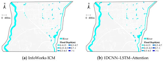
Figure 9.
Inundation range under heavy-rain scenario.
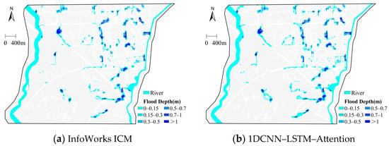
Figure 10.
Inundation range under torrential-rain scenario.
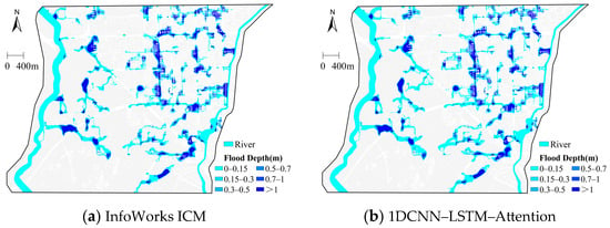
Figure 11.
Inundation range under heavy-rainstorm scenario.
To better analyze the differences between deep-learning models and numerical simulation models in predicting flood depth at the spatial scale, taking heavy-rainfall scenarios as an example, three triangular grids from the seven known susceptible points in the study area were selected. The maximum water depth predicted by the deep-learning model was compared with the numerical simulation results, as shown in Table 3. From Table 3, it can be observed that under the three rainfall scenarios, the maximum deviation of the deep-learning model prediction results was 0.05 m, the minimum deviation was 0.01 m, and the average error was 0.026 m. This indicated that the prediction accuracy of the deep-learning model was effective at the spatial scale.

Table 3.
Prediction error of flooding grid under torrential rain scenario.
4.1.2. Temporal Scale Performance Analysis
The 1DCNN–LSTM–Attention model, an improved version of the LSTM algorithm, combines the 1DCNN algorithm and the attention mechanism, making it more suitable for extracting complex nonlinear features from time-series data. To compare the differences before and after the algorithm improvements, the temporal scale performance of the prediction model was analyzed by comparing the three different deep-learning algorithms (1DCNN–LSTM- Attention, 1DCNN, and LSTM).
Based on the severity of flooding, five representative flooding points were selected from seven typical flooding points in the study area. The curves of the maximum inundation depth over time for the three flood prediction algorithms under the three rainfall scenarios are shown in Figure 12. Figure 12 shows that the time-series prediction curves of the maximum water depth for the five inundation points obtained using the three prediction algorithms were generally consistent with the simulation results of InfoWorks ICM.
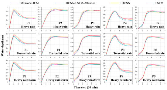
Figure 12.
Visualization of water depth timing prediction results.
Furthermore, the prediction results of the three flood algorithms for flooding point 1 were compared with the simulation results of InfoWorks ICM, as shown in Table 4. From Table 4, the 1DCNN–LSTM–Attention algorithm exhibited high robustness and negligible numerical errors. Under heavy-rainfall scenarios, the 1DCNN–LSTM–Attention prediction model exhibited RMSE and PCC values of 0.028 and 0.961, respectively. Under the torrential-rain scenarios, the RMSE and PCC values were 0.019 and 0.980, respectively. Under the extreme-rainfall scenarios, the RMSE and PCC values were 0.024 and 0.973, respectively. This was because the memory and forgetting mechanisms of the 1DCNN–LSTM–Attention algorithm made it easier to capture the nonlinear relationship between input and output values in long time series, thereby demonstrating better flood prediction performance.

Table 4.
Prediction accuracy of flooding time series.
4.1.3. Computational Time Performance Analysis
A rapid forecasting model was implemented using Python 3.6, Scikit-learn, and Numpy frameworks, with computations performed on an Intel(R) Core(TM) i7-13700 CPU. Ten random rainfall events were simulated using both the InfoWorks ICM and rapid urban inundation prediction models. The average simulation time for the InfoWorks ICM model was 39.75 min, and the simulation duration increased with increasing rainfall intensity and duration. The rapid urban inundation prediction model, based on 1DCNN–LSTM–Attention, had an average simulation time of 0.79 min, and simulation duration was not affected by the magnitude or duration of rainfall. Compared to the InfoWorks ICM model, the rapid urban inundation prediction model based on 1DCNN–LSTM–Attention was 50–100 times faster, meeting the requirements for timely warning and forecasting.
4.2. Analysis of the Impact of Urban River Flood Diversion on Pipe Network Drainage Capacity
4.2.1. Rainfall Scenario Setting
Rainfall simulation scenarios were established based on references [] and []. Rainfall scenarios with return periods of 1, 5, 10, 20, 30, and 50 years (hereafter referred to as 1, 5, ... 50a) were selected. Additionally, according to the “General Instructions for the Design of Jinshui River Diversion Project in Zhengzhou City”, the diversion outlet was designed for a flood standard of once-in-200-years, with a discharge flow of 75 m3/s. Therefore, a rainfall scenario corresponding to a 200-year return period was selected. Furthermore, to reflect the characteristics of extreme rainfall events on 20 July 2021 in Zhengzhou City (referred to as “7.20”), this rainfall event was also included as a simulation scenario to discuss and analyze the urban flooding characteristics under extreme heavy rainfall.
In summary, this study set the rainfall scenarios as 1a, 5a, 10a, 20a, 30a, 50a, 200a, and “7.20”; the rainfall hyetograph for each scenario is shown in Figure 13.
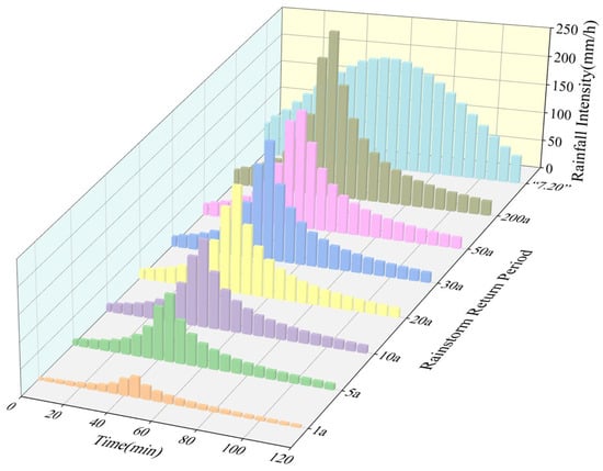
Figure 13.
Rainfall scenarios.
4.2.2. Drainage Capacity Evaluation Indicator
In InfoWorks ICM, the operational status of a pipe is measured using the surcharge state (S), which represents the ratio of water depth to pipe height. S is classified into three situations: (1) 0 ≤ S < 1 indicates that the pipe is not filled with rainwater and has not reached its maximum drainage capacity, as shown in Figure 14a; (2) S = 1 indicates that the pipe is filled with rainwater and the hydraulic gradient at the current moment is less than or equal to the pipe’s slope, representing the maximum drainage capacity, as shown in Figure 14b; (3) S = 2 indicates that the pipe is filled with rainwater and the hydraulic gradient at the current moment is greater than the pipe’s slope, also representing the maximum drainage capacity, as shown in Figure 14c. In this study, the drainage capacity of the pipes was assessed based on S, with the minimum recurrence interval of rainfall that fills the pipe considered as the drainage capacity of the pipe. Pipes with S = 1 and 2 are collectively referred to as fully charged pipes.

Figure 14.
Different cross-sectional views of pipes under various surcharge states.
4.2.3. Analysis of Pipe Drainage Capacity
The drainage capacity of the drainage pipes under existing condition and planning condition in the study area were simulated using the InfoWorks ICM model with input from eight rainfall scenarios. The results are shown in Figure 15. The percentage of the pipe length for each drainage capacity is shown in Figure 16.
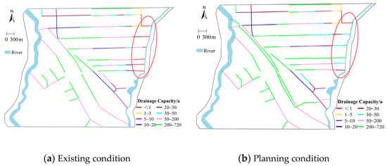
Figure 15.
Diagram of pipeline drainage capacity in the study area.
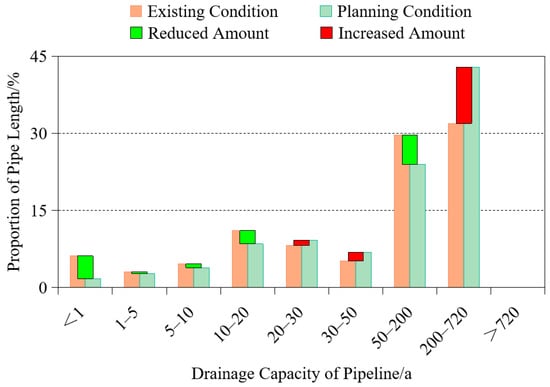
Figure 16.
Proportion of pipeline length under different drainage capacities (The reduced amount refers to the decrease in the proportion of pipe length under planning condition compared to the existing condition, while the increased amount refers to the opposite).
From Figure 15a and Figure 16, it is evident that under the existing conditions, the southwestern region of the study area exhibited higher drainage capacity in the pipelines, with drainage capacities exceeding the 50-year recurrence interval (a), whereas the northeastern region showed lower drainage capacity, with approximately 13.8% of the pipelines having capacities below the 10-year recurrence interval (a). Moreover, under extreme rainfall and flooding conditions, the drainage capacity of pipelines discharging into the Jinshui River was generally low, with some pipelines having capacities below the one-year recurrence interval (a). Overall, the distribution of the pipeline drainage capacity in the study area showed a pattern of being higher in the southwest and lower in the northeast.
As per Figure 15b and Figure 16, under the planning conditions, compared to the existing conditions, there was a general improvement in pipeline drainage capacity throughout the study area, with approximately 8.3% of pipelines having capacities below the 10-year recurrence interval (a), which was 5.5% lower than that under existing condition. Notably, the middle section of the Jinshui River showed a significant increase in the drainage capacity of pipelines discharging into it, with capacities increasing from below the one-year recurrence interval (a) to above the 20-year recurrence interval (a). This indicated that the Jinshui River diversion pipelines effectively discharged some of the water from the Jinshui River to the Jialu River, thereby enhancing the drainage capacity of the pipelines in the study area. However, under the extreme rainfall scenario of “7.20”, pipelines under both existing and planning conditions were fully surcharged, placing significant pressure on the urban underground pipeline network. Under such circumstances, it is essential to strengthen and improve urban flood warning and emergency response systems to minimize the impact of extreme rainfall and flooding disasters.
Furthermore, to verify whether the diversion pipelines met the design flood control standard of once-in-200-years, the maximum water levels inside the diversion pipelines were simulated under the 200-year recurrence interval rainfall scenario, as shown in Figure 17. The flow process at the outlet of the diversion pipelines is illustrated in Figure 18. Figure 17 indicates that at the time when the maximum simulated results were obtained under the 200-year rainfall scenario, the entrance of the diversion pipelines was already fully inundated, whereas the outlet of the diversion pipelines was not yet fully inundated, with a maximum surcharge status of 0.91. This indicated that the diversion pipelines were at the critical point between being fully inundated and not fully inundated. Figure 18 shows that under the 200-year rainfall scenario, the flow at the outlet of the diversion pipelines initially increased and then stabilized, with a maximum discharge flow of 73 m3/s. This verification confirms that the diversion pipelines met the design flood control standard of once-in-200-years, aligning with the expected goals of the Jinshui River diversion project in Zhengzhou City.
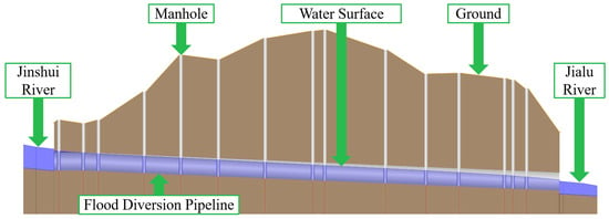
Figure 17.
Cross-section of maximum water volume in diversion pipelines under the 200-year rainfall scenario.
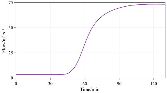
Figure 18.
Flow process line at the outlet of diversion pipelines under the 200-year rainfall scenario.
4.3. Analysis of the Impact of Urban River Flood Diversion on Inundation Characteristics
By inputting the eight rainfall scenarios from Section 4.2.1 into the 1DCNN–LSTM–Attention model, the inundation situations under the existing and planning conditions in the study area were predicted, as shown in Figure 19. A comparison of the maximum water depth and maximum inundation area under each rainfall scenario is shown in Figure 20.
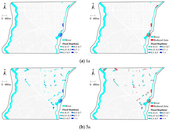
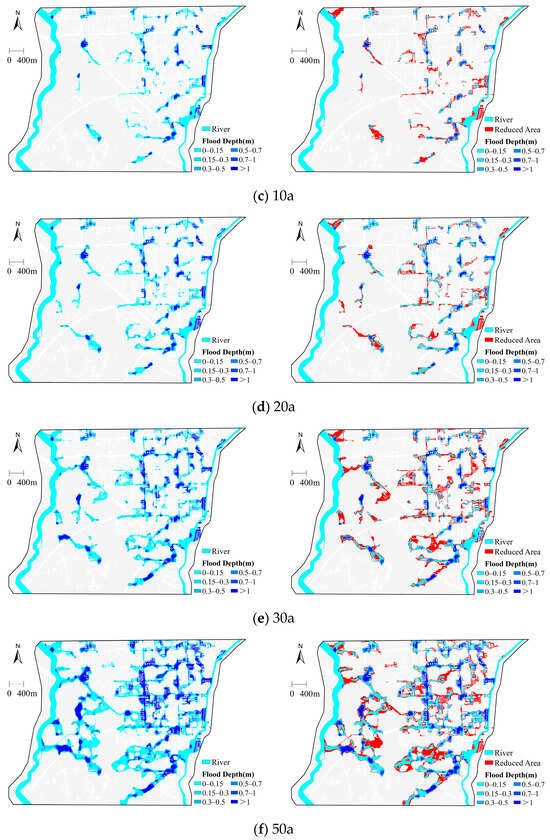
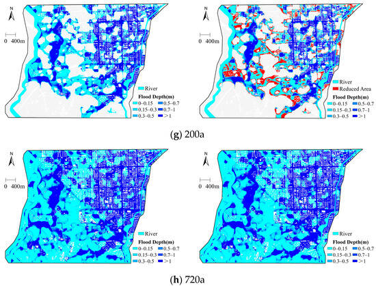
Figure 19.
Inundation maps under existing and planning conditions (the left shows the inundation map under existing conditions, while the right displays the inundation map under planned conditions).
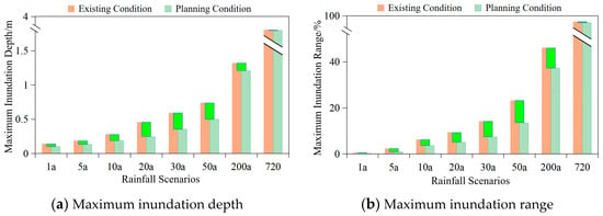
Figure 20.
Comparison of maximum inundation depth and range under existing and planning conditions.
Figure 19 shows that under both existing and planning conditions, the extent of inundation was smaller in the southwestern region of the study area and larger in the northeast region. This “less in the southwest, more in the northeast” inundation characteristic corresponds to the distribution pattern of the drainage capacity in the area, which was characterized by being higher in the southwest, lower in the northeast. The inundation pattern was closely related to the distribution of surface types in the study area. The southwestern region is mainly covered by permeable surfaces such as bare soil or vegetation, whereas the northeastern region consists mostly of hardened surfaces such as buildings and roads, resulting in more severe inundation.
Moreover, by comparing the inundation maps under the existing and planning conditions, it can be observed that the Jinshui River diversion project effectively reduced inundation disasters. The reduction in inundation disasters was particularly prominent under rainfall scenarios of 1a, 5a, 10a, 20a, 30a, 50a, and 200a, while it was less significant under the “7.20” rainfall scenario. This was because the maximum drainage capacity of the diversion channels was designed for a 200-year return period. When the return period of rainfall exceeded 200 years, the upstream sections of the diversion channels began to surcharge, reaching a maximum S of 2 (as shown in Figure 17), indicating inadequate drainage capacity. Consequently, when the return period exceeded 200 years, the diversion channels became fully inundated, rendering them unable to effectively mitigate inundation disasters, which explains the limited reduction in inundation effects under the “7.20” rainfall scenario.
As shown in Figure 20, the Jinshui River diversion project effectively reduced both the maximum water depth and the extent of inundation. In particular, the reduction in inundation disasters was more significant under rainfall scenarios of 20a, 30a, and 50a. Under the 30a rainfall scenario, the maximum water depth decreased by 0.24 m, and the proportion of the maximum inundation extent decreased by 6.73%, corresponding to a maximum inundation area of 1.46 km2, which is approximately equivalent to the area of 205 standard football fields. However, under the “7.20” rainfall scenario, the reduction in inundation disasters was less pronounced. The maximum water depth decreased by only 0.01 m, and the proportion of the maximum inundation extent decreased by 0.23%. This highlights the importance of pre-disaster warning and post-disaster emergency responses, especially in the face of extreme rainfall events such as “7.20”. In the context of modern urban development, it is essential to establish and strengthen urban inundation warnings and emergency response systems to mitigate urban disasters caused by heavy rainfall inundation.
5. Conclusions
The Jinshui River diversion project in Zhengzhou, China, was used as a case study to explore a city inundation prediction method based on the 1DCNN–LSTM–Attention model. This study investigated the mitigation effect of urban river diversion on inundation disasters from two perspectives: pipeline drainage capacity and inundation submergence characteristics. The main conclusions are as follows:
(1) The urban inundation rapid prediction model based on 1DCNN–LSTM- Attention demonstrated good accuracy, with an average absolute error of 0.026 m at the spatial scale and a PCC greater than 0.9 at the temporal scale. It also achieved a 50- to 100-fold acceleration compared to the InfoWorks ICM model. In addition, it had better performance than 1DCNN and LSTM.
(2) The drainage capacity of pipelines in the study area exhibited a “higher in the southwest and lower in the northeast” distribution pattern. The river diversion project significantly enhanced the drainage capacity of the inlet pipes and addressed the problem of inlet pipe surcharge. The diversion pipelines met the design flood control standard of once-in-200-years with a maximum discharge flow of 73 m3/s under this rainfall scenario, which aligns with the project’s expected goals.
(3) The inundation submergence area in the study area shows a “less in the southwest, more in the northeast” distribution pattern. The river diversion project effectively reduced the inundation area and depth. The most significant reduction in inundation disasters was observed under the 30a rainfall scenario, with a decrease of 0.24 m in the maximum water depth and a reduction of 1.46 km2 in the maximum inundation area, approximately equivalent to 205 standard football fields.
Author Contributions
Conceptualization, D.Z. and Z.Z.; methodology, D.Z. and Z.Z.; software, D.Z.; validation, D.Z. and J.X.; formal analysis, Q.S.; investigation, Z.Z. and J.X.; resources, Q.S.; Data Curation, Z.Z.; writing—original draft preparation, D.Z. and Z.Z.; writing—review and editing, Q.S.; visualization, D.Z.; supervision, Q.S.; project administration, Q.S.; funding acquisition, D.Z. All authors have read and agreed to the published version of the manuscript.
Funding
This research was supported by the Key Laboratory of Hydrometeorological Disaster Mechanism and Warning of Ministry of Water Resources project (Grant No. HYMED202208).
Data Availability Statement
The data presented in this study are available on request from the corresponding author.
Conflicts of Interest
The authors declare that they have no known competing financial interests or personal relationships that could have appeared to influence the work reported in this paper.
References
- Li, K.; Chen, Y. Identifying and characterizing frequency and maximum durations of surface urban heat and cool island across global cities. Sci. Total Environ. 2023, 859, 160218. [Google Scholar] [CrossRef] [PubMed]
- Löwe, R.; Mair, M.; Pedersen, A.N.; Kleidorfer, M.; Rauch, W.; Arnbjerg-Nielsen, K. Impacts of urban development on urban water management–limits of predictability. Comput. Environ. Urban Syst. 2020, 84, 101546. [Google Scholar] [CrossRef]
- Prathipati, V.K.; CV, N.; Konatham, P. Inconsistency in the frequency of rainfall events in the Indian summer monsoon season. Int. J. Climatol. 2019, 39, 4907–4923. [Google Scholar] [CrossRef]
- Zhang, Q.; Wu, Z.; Guo, G.; Zhang, H.; Tarolli, P. Explicit the urban waterlogging spatial variation and its driving factors: The stepwise cluster analysis model and hierarchical partitioning analysis approach. Sci. Total Environ. 2021, 763, 143041. [Google Scholar] [CrossRef] [PubMed]
- Billa, W.D.S.; Santos, L.B.L.; Negri, R.G. Analyzing the spatial interactions between rainfall levels and flooding prediction in São Paulo. Trans. GIS 2023, 27, 2159–2174. [Google Scholar] [CrossRef]
- Yan, M.; Yang, J.; Ni, X.; Liu, K.; Wang, Y.; Xu, F. Urban waterlogging susceptibility assessment based on hybrid ensemble machine learning models: A case study in the metropolitan area in Beijing, China. J. Hydrol. 2024, 630, 130695. [Google Scholar] [CrossRef]
- Zhao, D.; Xu, H.; Li, Y.; Yu, Y.; Duan, Y.; Xu, X.; Chen, L. Locally opposite responses of the 2023 Beijing–Tianjin–Hebei extreme rainfall event to global anthropogenic warming. npj Clim. Atmos. Sci. 2024, 7, 38. [Google Scholar] [CrossRef]
- Han, J.; Wang, C.; Deng, S.; Lichtfouse, E. China’s sponge cities alleviate urban flooding and water shortage: A review. Environ. Chem. Lett. 2023, 21, 1297–1314. [Google Scholar] [CrossRef]
- Li, J.; Jiang, Y.; Zhai, M.; Gao, J.; Yao, Y.; Li, Y. Construction and application of sponge city resilience evaluation system: A case study in Xi’an, China. Environ. Sci. Pollut. Res. 2023, 30, 62051–62066. [Google Scholar] [CrossRef]
- Tan, Y.; Cheng, Q.; Lyu, F.; Liu, F.; Liu, L.; Su, Y.; Yuan, S.; Xiao, W.; Liu, Z.; Chen, Y. Hydrological reduction and control effect evaluation of sponge city construction based on one-way coupling model of SWMM-FVCOM: A case in university campus. J. Environ. Manag. 2024, 349, 119599. [Google Scholar] [CrossRef]
- Zha, X.; Fang, W.; Zhu, W.; Wang, S.; Mu, Y.; Wang, X.; Luo, P.; Zainol, M.R.R.M.A.; Zawawi, M.H.; Chong, K.L.; et al. Optimizing the deployment of LID facilities on a campus-scale and assessing the benefits of comprehensive control in Sponge City. J. Hydrol. 2024, 635, 131189. [Google Scholar] [CrossRef]
- Van den Hoven, K.; Kroeze, C.; Van Loon-Steensma, J.M. Characteristics of realigned dikes in coastal Europe: Overview and opportunities for nature-based flood protection. Ocean Coast. Manag. 2022, 222, 106116. [Google Scholar] [CrossRef]
- Xia, J.; Cheng, Y.; Zhou, M.; Deng, S.; Zhang, X. Experimental and numerical model studies of dike-break induced flood processes over a typical floodplain domain. Nat. Hazards 2023, 116, 1843–1861. [Google Scholar] [CrossRef]
- Yulius, E.; Setiawan, F.; Nuryati, S.; Gunarti, A.S.S. Modeling and Simulation of Flow through The Construction of River Cover Embankment: Case Study of Sei Wampu Weir, Langkat Regency, Indonesia. E3S Web Conf. 2024, 500, 02003. [Google Scholar] [CrossRef]
- Bera, M.K. Flood emergency management in a municipality in the Czech Republic: A study of local strategies and leadership. Nat. Hazards Res. 2023, 3, 385–394. [Google Scholar] [CrossRef]
- Chen, J.; Li, Y.; Zhang, C.; Tian, Y.; Guo, Z. Urban Flooding Prediction Method Based on the Combination of LSTM Neural Network and Numerical Model. Int. J. Environ. Res. Public Health 2023, 20, 1043. [Google Scholar] [CrossRef] [PubMed]
- Khan, I.; Lei, H.; Shah, A.A.; Khan, I.; Muhammad, I. Climate change impact assessment, flood management, and mitigation strategies in Pakistan for sustainable future. Environ. Sci. Pollut. Res. 2021, 28, 29720–29731. [Google Scholar] [CrossRef] [PubMed]
- Perera, D.; Agnihotri, J.; Seidou, O.; Djalante, R. Identifying societal challenges in flood early warning systems. Int. J. Disaster Risk Reduct. 2020, 51, 101794. [Google Scholar] [CrossRef]
- Liao, Y.; Wang, Z.; Chen, X.; Lai, C. Fast simulation and prediction of urban pluvial floods using a deep convolutional neural network model. J. Hydrol. 2023, 624, 129945. [Google Scholar] [CrossRef]
- Luo, P.; Luo, M.; Li, F.; Qi, X.; Huo, A.; Wang, Z.; He, B.; Takara, K.; Nover, D.; Wang, Y. Urban flood numerical simulation: Research, methods and future perspectives. Environ. Model. Softw. 2022, 156, 105478. [Google Scholar] [CrossRef]
- Tang, X.; Hong, H.; Shu, Y.; Tang, H.; Li, J.; Liu, W. Urban waterlogging susceptibility assessment based on a PSO-SVM method using a novel repeatedly random sampling idea to select negative samples. J. Hydrol. 2019, 576, 583–595. [Google Scholar] [CrossRef]
- Zhu, Z.; Zhang, Y. Flood disaster risk assessment based on random forest algorithm. Neural Comput. Appl. 2022, 34, 3443–3455. [Google Scholar] [CrossRef]
- Wu, J.; Li, J.; Wang, X.; Xu, L.; Li, Y.; Li, J.; Zhang, Y.; Xie, T. Methods for Constructing a Refined Early-Warning Model for Rainstorm-Induced Waterlogging in Historic and Cultural Districts. Water 2024, 16, 1290. [Google Scholar] [CrossRef]
- Zhang, J.; Li, X.; Zhang, H. Research on urban waterlogging risk prediction based on the coupling of the BP neural network and SWMM model. J. Water Clim. Chang. 2023, 14, 3417–3434. [Google Scholar] [CrossRef]
- Zhang, Z.; Jian, X.; Chen, Y.; Huang, Z.; Liu, J.; Yang, L. Urban waterlogging prediction and risk analysis based on rainfall time series features: A case study of Shenzhen. Front. Environ. Sci. 2023, 11, 1131954. [Google Scholar] [CrossRef]
- Lingkai, S.; Jian, W.; Wangpeng, X.; Zhaobo, G.; Wei, X.; Shi, Z. Risk Assessment of Urban Flooding Using InfoWorks ICM Model: A Case Study of Tangxun Lake Watershed in Wuhan. In International Conference on Environmental Science and Technology; Springer Nature Switzerland: Cham, Switzerland, 2023; pp. 135–156. [Google Scholar] [CrossRef]
- Ma, S.; Zayed, T.; Xing, J.; Shao, Y. A state-of-the-art review for the prediction of overflow in urban sewer systems. J. Clean. Prod. 2023, 434, 139923. [Google Scholar] [CrossRef]
- Yang, Y.; Li, J.; Huang, Q.; Xia, J.; Li, J.; Liu, D.; Tan, Q. Performance assessment of sponge city infrastructure on stormwater outflows using isochrone and SWMM models. J. Hydrol. 2021, 597, 126151. [Google Scholar] [CrossRef]
- Zhou, R.; Zheng, H.; Liu, Y.; Xie, G.; Wan, W. Flood impacts on urban road connectivity in southern China. Sci. Rep. 2022, 12, 16866. [Google Scholar] [CrossRef]
- Kao, I.F.; Liou, J.Y.; Lee, M.H.; Chang, F.J. Fusing stacked autoencoder and long short-term memory for regional multistep-ahead flood inundation forecasts. J. Hydrol. 2021, 598, 126371. [Google Scholar] [CrossRef]
- Xie, S.; Wu, W.; Mooser, S.; Wang, Q.J.; Nathan, R.; Huang, Y. Artificial neural network based hybrid modeling approach for flood inundation modeling. J. Hydrol. 2021, 592, 125605. [Google Scholar] [CrossRef]
- Chen, G.; Hou, J.; Liu, Y.; Xue, S.; Wu, H.; Wang, T.; Lv, J.; Jing, J.; Yang, S. Urban inundation rapid prediction method based on multi-machine learning algorithm and rain pattern analysis. J. Hydrol. 2024, 633, 131059. [Google Scholar] [CrossRef]
- Gopalan, S.P.; Champathong, A.; Sukhapunnaphan, T.; Nakamura, S.; Hanasaki, N. Potential impact of diversion canals and retention areas as climate change adaptation measures on flood risk reduction: A hydrological modelling case study from the Chao Phraya River Basin, Thailand. Sci. Total Environ. 2022, 841, 156742. [Google Scholar] [CrossRef] [PubMed]
- Wang, K.; Wang, Z.; Liu, K.; Cheng, L.; Bai, Y.; Jin, G. Optimizing flood diversion siting and its control strategy of detention basins: A case study of the Yangtze River. China. J. Hydrol. 2021, 597, 126201. [Google Scholar] [CrossRef]
- Han, L.; Cao, L.; Wu, Q.; Huang, J.; Yu, B. Identification of Surface Deformation-Sensitive Features under Extreme Rainfall Conditions in Zhengzhou City Based on Multi-Source Remote Sensing Data. Appl. Sci. 2023, 13, 13063. [Google Scholar] [CrossRef]
- Ni, J.; Zhao, Y.; Li, B.; Liu, J.; Zhou, Y.; Zhang, P.; Shao, J.; Chen, Y.; Jin, J.; He, C. Investigation of the impact mechanisms and patterns of meteorological factors on air quality and atmospheric pollutant concentrations during extreme weather events in Zhengzhou city, Henan Province. Atmos. Pollut. Res. 2023, 14, 101932. [Google Scholar] [CrossRef]
- Lou, Y.; Wang, P.; Li, Y.; Wang, L.; Chen, C.; Li, J.; Hu, T. Management of the designed risk level of urban drainage system in the future: Evidence from haining city, China. J. Environ. Manag. 2024, 351, 119846. [Google Scholar] [CrossRef]
- Xue, J.; Wang, Q.; Zhang, M. A review of non-point source water pollution modeling for the urban–rural transitional areas of China: Research status and prospect. Sci. Total Environ. 2022, 826, 154146. [Google Scholar] [CrossRef]
- Yin, D.; Evans, B.; Wang, Q.; Chen, Z.; Jia, H.; Chen, A.S.; Fu, G.; Ahmad, S.; Leng, L. Integrated 1D and 2D model for better assessing runoff quantity control of low impact development facilities on community scale. Sci. Total Environ. 2020, 720, 137630. [Google Scholar] [CrossRef]
- Li, Z.; Liu, F.; Yang, W.; Peng, S.; Zhou, J. A survey of convolutional neural networks: Analysis, applications, and prospects. IEEE Trans. Neural Netw. Learn. Syst. 2021, 33, 6999–7019. [Google Scholar] [CrossRef]
- Taye, M.M. Theoretical understanding of convolutional neural network: Concepts, architectures, applications, future directions. Computation 2023, 11, 52. [Google Scholar] [CrossRef]
- Zhang, X.; Zhang, X.; Wang, W. Convolutional Neural Network. In Intelligent Information Processing with Matlab; Springer Nature Singapore: Singapore, 2023; pp. 39–71. [Google Scholar] [CrossRef]
- Li, B.; Li, R.; Sun, T.; Gong, A.; Tian, F.; Khan, M.Y.A.; Ni, G. Improving LSTM hydrological modeling with spatiotemporal deep learning and multi-task learning: A case study of three mountainous areas on the Tibetan Plateau. J. Hydrol. 2023, 620, 129401. [Google Scholar] [CrossRef]
- Tang, A.; Jiang, Y.; Yu, Q.; Zhang, Z. A hybrid neural network model with attention mechanism for state of health estimation of lithium-ion batteries. J. Energy Storage 2023, 68, 107734. [Google Scholar] [CrossRef]
- Ministry of Housing and Urban-Rural Development of the People’s Republic of China. Architectural Water Supply and Drainage Design Standard (GB 50015-2019); China Planning Press: Beijing, China, 2019. [Google Scholar]
- Zhengzhou Municipal Bureau of Natural Resources and Planning. Technical Regulations for Urban Planning and Management in Zhengzhou City; Zhengzhou Municipal Bureau of Natural Resources and Planning: Zhengzhou, China, 2019. [Google Scholar]
Disclaimer/Publisher’s Note: The statements, opinions and data contained in all publications are solely those of the individual author(s) and contributor(s) and not of MDPI and/or the editor(s). MDPI and/or the editor(s) disclaim responsibility for any injury to people or property resulting from any ideas, methods, instructions or products referred to in the content. |
© 2024 by the authors. Licensee MDPI, Basel, Switzerland. This article is an open access article distributed under the terms and conditions of the Creative Commons Attribution (CC BY) license (https://creativecommons.org/licenses/by/4.0/).