Article

Water Quality from Natural Sources for Sustainable Agricultural Development Strategies: Galapagos, Ecuador

by
Paúl Carrión-Mero
1,2,
Fernando Morante-Carballo
1,3,4,
Josué Briones-Bitar
1,2,
María Jaya-Montalvo
1,2,
Emily Sánchez-Zambrano
1,2,
Joselyne Solórzano
1,2,
Jenifer Malavé-Hernández
1,2,*,
Francisco Javier Montalván Toala
5,6,
Jaime Proaño
7,8,
Ángel Flor-Pineda
8,9 and
Ramón Espinel
8,9
1
Centro de Investigación y Proyectos Aplicados a las Ciencias de la Tierra (CIPAT), ESPOL Polytechnic University, Guayaquil 09015863, Ecuador
2
Facultad de Ingeniería en Ciencias de la Tierra (FICT), ESPOL Polytechnic University, Guayaquil 09015863, Ecuador
3
Facultad de Ciencias Naturales y Matemáticas (FCNM), ESPOL Polytechnic University, Guayaquil 09015863, Ecuador
4
Geo-Recursos y Aplicaciones (GIGA), ESPOL Polytechnic University, Guayaquil 09015863, Ecuador
5
Department of Biology and Geology, Physics and Inorganic Chemistry, Higher School of Experimental Sciences and Technology, Rey Juan Carlos University, c/Tulipán s/n, 28933 Móstoles, Spain
6
Facultad de Ciencias de la Ingeniería, Universidad Estatal Península de Santa Elena (UPSE), La Libertad 240204, Ecuador
7
Facultad de Ciencias de la Vida (FCV), ESPOL Polytechnic University, Guayaquil 09015863, Ecuador
8
Centro de Investigaciones Rurales (CIR), ESPOL Polytechnic University, Guayaquil 09015863, Ecuador
9
Facultad de Ciencias Sociales y Humanísticas (FCSH), ESPOL Polytechnic University, Guayaquil 09015863, Ecuador
*
Author to whom correspondence should be addressed.
Water 2024, 16(11), 1516; https://doi.org/10.3390/w16111516
Submission received: 20 April 2024 / Revised: 10 May 2024 / Accepted: 15 May 2024 / Published: 25 May 2024
(This article belongs to the Special Issue Evaluation of Water Quality and Soil Health in Agroecosystems)

Abstract

:
Water is an essential element for agricultural sustainability. In volcanic islands, freshwater sources are limited, challenging the local farming water supply. Rainfall dependence in the Galapagos Islands limits continuous agriculture, and despite using natural water sources, their irrigation quality is little known. This study aimed to carry out a control–diagnosis of irrigation water quality of the natural sources of the four agrarian islands of the Galapagos, considering water quality parameters for the proposal of sustainability strategies in the water and agricultural context. The workflow included (i) freshwater supply situation diagnosis, (ii) physicochemical parameters measurement and hydrochemical characterisation, and (iii) irrigation analysis and sustainability strategies configuration. Results indicated that of the 34 sources analysed, 55.88% are suitable for irrigation and are located in San Cristobal and Santa Cruz. The remaining 44.12% showed problems with parameters such as faecal coliforms, salinity, metals, carbonates, BOD5, and COD above the national permitted limits. Six strategies for water and agricultural sustainability are proposed, including periodic water monitoring, academy–government–community projects, community water board creation, water sowing and harvesting systems, effective management of effluent, and agricultural strengthening. The study guides comprehensive hydric management initiatives to benefit agrarian development and food security, aligning with SDGs 2 and 6.

1. Introduction

Water is necessary for all human activities, including its domestic and productive use in a country [1,2]. Water covers 71% of the Earth’s surface, with 96.5% contained in the oceans as salt water and the remaining 2.5% as freshwater on the surface, underground, and frozen in glaciers and polar caps [3]. This small percentage of freshwater is becoming an increasingly scarce and degraded natural resource for millions worldwide [4,5].
The physical lack of available water to satisfy demand [6]; the level of development of the infrastructures that control storage, distribution, and access [7]; and the institutional capacity to provide the necessary water services [8] are the three main aspects that stand out in water scarcity. The World Bank and the United Nations (UN) affirm that more than two billion people live in countries experiencing water stress (or water scarcity) [9,10]. Furthermore, more than 1.1 billion people have inadequate access to clean drinking water worldwide, and approximately 2.6 billion lack basic sanitation facilities [11,12].
Population growth, economic development, tourism, and consumption patterns intensify the problem of scarcity [13,14]. These problems lead to the search for solutions to conserve the quantity and quality of water, especially in coastal areas, arid–semi-arid areas, and island territories [15,16]. On small islands, freshwater lenses, rainfall, and aquifers are the primary sources of water for human consumption [17,18]. However, these sources are affected by anthropogenic pollution and seawater salinization [19].
For example, the island of Crete (Greece) is subject to significant water resource management challenges, mainly due to its location and climate [20,21]. On this island, the intensive exploitation of groundwater (mainly due to the increase in agricultural activity and tourism in the last 50 years) has led to a decrease in groundwater level, causing contamination of the coastal aquifer due to seawater intrusion [22,23]. The Canary Islands (Spain) experience a similar situation due to the overexploitation of its aquifer due to the intensification of agriculture, the increase in population, and the development of tourism [24]. The Canary Islands are characterised by extreme aridity since rainfall is scarce and irregular, which has led to an increase in the use of desalination plants to supply the population [25,26].
Freshwater systems on islands represent sensitive environments prone to irreversible changes when they experience unexpected disturbances. The deterioration of water quality has become a global concern [27,28]. The expansion of industries, agriculture, and tourism often causes water quality degradation from surface and groundwater sources [29,30], limiting its posterior use [31,32]. Therefore, monitoring, evaluation, modelling, and implementation of appropriate management actions are necessary to avoid further deterioration of water quality [33,34], allowing for the continuous use of this resource sustainably in basic activities.
The United Nations’ Sixth Sustainable Development Goal (SDG) is to ensure the availability and sustainable management of water and sanitation for all by 2030 [35,36]. Fulfilling this goal is incredibly challenging for island systems with limited freshwater supplies, such as the Galapagos Islands.
UNESCO declared the Galapagos a World Heritage Site in 1978, a Biosphere Reserve in 1984, and a Ramsar Site in 2001 [37,38] due to its high biodiversity (endemic) and distinctive environment in addition to its great geodiversity value [39]. In 2023, Galapagos National Park received 329,475 tourists, raising the compound annual growth rate of tourist arrivals of the last ten years to 4.82% [40]. Higher water and food demand puts pressure on the fragile ecosystem and increases water degradation [41].
One of the main problems affecting the archipelago is the contamination of local freshwater resources, making them unsuitable for consumption and domestic use (mainly due to the presence of Escherichia Coli (E. coli) and Entamoeba histolica) [42,43]. On Santa Cruz Island, several researchers have been evaluating the water quality since 2007 [41,44,45], finding untreated wastewater discharges (increased amount of coliforms) as the leading causes of pollution, overexploitation of underground sources (causing saline pollution), and agricultural runoff (enrichment of water with nutrients and coliforms). On San Cristobal Island, some studies evaluate data from 2013 to 2017 on microbiological (total coliforms, E. coli and Enterococcus) and physicochemical parameters (conductivity, pH, phosphates, dissolved oxygen, residual chlorine, and salinity, among others) [46,47,48], with results that show high-quality drinking water, but with the detection of E. coli of 2–30%. On Isabela Island, monitoring carried out in 2019 [43,49] revealed the presence of sixteen pesticide residues in the coastal waters of urban areas (seven representing a high ecological risk for the biota) and trace content of total coliforms (E. coli), high salinity, conductivity, and pH in household water samples.
In recent years, most activities aimed at evaluating and protecting water quality have been characterised by the lack of coordination between the different water institutions in the Galapagos. Decision-making resides in the Governing Council of the Galapagos Special Regime (CGREG, by its Spanish acronym), whose function is to provide drinking water and sanitation to the citizens of the Galapagos, as well as water for irrigation in the agricultural areas of the islands. In this study, prepared under the project “Preparation of studies to formulate the irrigation and drainage plan of Galapagos”, in cooperation with and financing of the CGREG in 2022, the monitoring of water sources on the four islands of Galapagos with agricultural activity is made (San Cristobal, Santa Cruz, Isabela, and Floreana).
One of the axes of the project was the characterisation of natural water sources for agricultural strengthening. Sampedro et al. (2020) [50] reported that “approximately 75% of the agricultural food supply was transported from the Ecuadorian mainland in 2017” due to the increase in tourism experienced by the islands [51]. But in 2020, due to the COVID-19 pandemic and the decline in tourism, several locals returned to the rural areas of the islands, where the entire population was affected by the decrease in production (not enough for local market supply) and labour (the population residing in rural areas has decreased from 42% in 1974 to 18.6% in 2015) [52], evidencing the productive needs of the islands.
Considering the background above, this article seeks to answer the following questions: What would be the guidelines for sustainability in the water quality of the Galapagos Islands, which promote the sustainability of agriculture on the islands? What would be the water use system for agricultural use that would provide quality and sustainability? Therefore, the objective of this research is to carry out a control–diagnosis of the quality of water for irrigation of the natural sources of the islands of San Cristobal, Santa Cruz, Isabela, and Floreana (Galapagos) through the measurement and analysis of physicochemical, micro-biological and hydrochemical parameters, and the calculation of irrigation water quality indices. Based on the study of water quality and the strengths, weaknesses, opportunities, and threats (SWOT) matrix, sustainability strategies for water resources are established in the agricultural context of the islands.

2. Materials and Methods

2.1. Geographical Context

The Galapagos Islands are one of the 24 provinces of Ecuador and are located in the Eastern Tropical Pacific, approximately 1000 km west of the coasts of continental Ecuador (Figure 1a). The archipelago comprises 13 major islands and more than 200 islets and outcropping rocks, covering a total area of about 7985 km2 [53]. According to data from the last demographic census in 2015, the island’s population was 25,244 inhabitants [54]. Santa Cruz is the most populated island, with 15,701 inhabitants, followed by San Cristobal (7088), Isabela (2344), and Floreana (111) [54].
In a geological context, the Galapagos Islands comprise a set of volcanic islands created as a result of the eruptive activity of the Galapagos hotspot below the Nazca Plate [55,56], which has a path that spans the Carnegie Ridge from the Equator subduction zone to the archipelago (Figure 1a) [57]. Generally, typical rocks are lavas of geochemistry, predominantly basaltic, giving origin to typical geophorms such as shield volcanoes, lava tunnels, and hornitos [58].
The Galapagos climate is governed by the intertropical convergence zone (ITCZ) and the El Niño–Southern Oscillation (ENSO), in a complex interaction between marine currents and winds that module its dynamics [59,60]. The climate is characterised by being arid to semi-arid in most of the islands. The region has two seasons, one rainy (December-May), with temperatures between 25 °C and 26 °C, and another dry one (June–November), with temperatures between 21 °C and 22 °C [61]. Topography is another influential factor in climate modulation, which gives rise to three main microclimates or climatic zones: the dry lowlands (arid zone), the transition zones, and the humid highlands [62]. Precipitation ranges from an annual average of 100 to 300 mm of rain in the arid zones [63] and from 1500 to more than 2000 mm of rain in the humid zones, according to records from Santa Cruz and San Cristobal [64,65].
Around 97% of the islands correspond to protected areas managed by the Galapagos National Park (PNG), and the remaining 3% are areas intended for urban or rural settlements. The rural area includes the humid lands located in the high parts of the inhabited islands (82.35 km2 in San Cristobal, 111.76 km2 in Santa Cruz, 52.33 km2 in Isabela, and 2.90 km2 in Floreana), taken advantage of due to their favourable climate for development agricultural and livestock [53]. Currently, short-cycle crops (vegetables and grains) and long-cycle crops (coffee, cocoa, and fruits) are produced. Likewise, breeding domestic birds, pigs, and cattle is carried out [66].
This study focuses on the agricultural (rural) areas of the archipelago’s four populated islands: Santa Cruz, San Cristobal, Isabela, and Floreana (Figure 1b). Agriculture on the islands has problems related to water scarcity, territorial limitations, and high production costs. Only San Cristobal has a permanent source of fresh water (the natural lagoon El Junco, in the mountainous area) [67]. However, freshwater natural availability is not enough to cover local agricultural needs, so on the four islands, rainwater provision on roofs and reservoirs [68] is common; currently, there are around 154 reservoirs [69]. Also, to improve agricultural development, state projects have promoted the use of greenhouses [70] and the conditioning of natural structures for water collection (e.g., Crater in the Cerro Cascajo-Camote sector in Santa Cruz) [71].

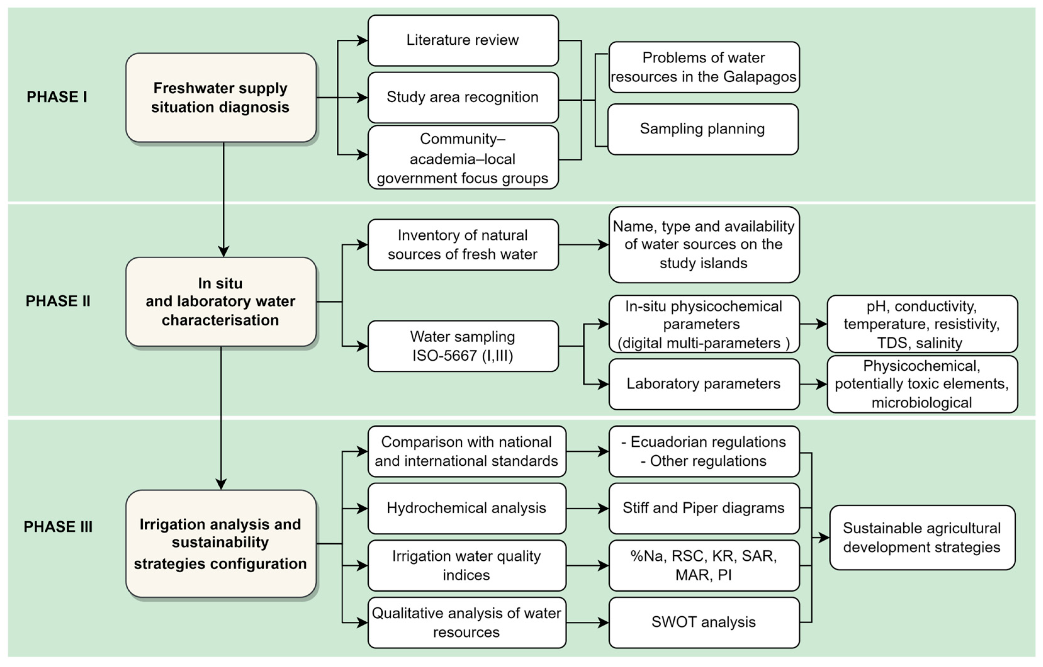
2.2. Methodological Approach and Study Phases

The method consists of a study through the inventory, sampling, and analysis of quality and hydrochemistry of the natural water sources on the four islands associated with the agricultural sectors of the Galapagos. A hydrochemical characterisation is carried out to classify the type of water. Furthermore, the in situ and laboratory parameters are compared with national and international environmental regulations, and indices are calculated to diagnose water quality for irrigation. With the hydrochemical characterisation and data on water quality parameters for irrigation, sustainable agriculture strategies are formulated. The characterisation and analysis of water quality resources included three work phases: (i) freshwater supply situation diagnosis, (ii) in situ and laboratory water characterisation, and (iii) irrigation analysis and sustainability strategies configuration (Figure 2).

2.2.1. Phase I: Freshwater Supply Situation Diagnosis

This phase considered planning irrigation water quality monitoring sites concerning natural sources. For this, we analysed base information on geology [56,72,73] and previous water quality studies [41,47,74,75]; a geodatabase (administrative boundaries, urban and rural structures, hydrography, farming areas, and the location of water structures) provided by government entities of the Galapagos Islands (CGREG, Ministry of Agriculture and Livestock (MAG, by its acronym in Spanish), Municipality of Santa Cruz and Municipal Public Company of Drinking Water and Sewage of Santa Cruz E.P. (EPMAPASC, by its acronym in Spanish)); and inventories of water sources provided by the Rural Research Centre (CIR, by its acronym in Spanish) of the ESPOL Polytechnic University (Guayaquil, Ecuador), to identify and geographically locate the natural water sources existing on each island. The selection of the natural water sources for sampling considered criteria such as (i) proximity of the source to active agricultural areas, (ii) accessibility, and (iii) location outside protected areas.
Finally, in this phase, two focus group [76] meetings were held between representatives of academia (CIR and CIPAT (Centro de Investigación y Proyectos Asociados a las Ciencias de la Tierra, by its acronym in Spanish)), government (CGREG, MAG, PNG), and farmers from the four islands to socialise the activities to develop, share field monitoring planification, and discuss the considerations during visits to the different islands. The first focus group was aimed at farmers on the San Cristobal and Santa Cruz islands, and the second was aimed at farmers on the Isabela and Floreana islands. Both consisted of a participatory workshop for the socialization of sampling activities of natural water sources developed in three stages: (i) presentation of key actors and introduction of the study objectives, (ii) presentation of the field sampling design, and (iii) feedback and guidelines for water inventory and sampling by environmental technicians.

2.2.2. Phase II: In Situ and Laboratory Water Characterisation

Thirty-four natural water sources were inventoried on the four islands (San Cristobal, Santa Cruz, Isabela, and Floreana) during field trips in February and March 2022. All of these sources were analysed in situ by measuring their water physicochemical parameters. Also, 17 water sources were sampled for analysis in the laboratory.
The physicochemical water parameters measured in situ were hydrogen potential (pH), conductivity, temperature, salinity, and total dissolved solids (TDS). These measurements were carried out using the digital portable multi-parameters (Multi 3430; WTW®, Weilheim, Germany) and (HI9829; HANNA®, Woonsocket, RI, USA). Meanwhile, for sampling, we followed the procedure of the national regulations NTE-INEN 2169 [77] and 2176 [78] (Ecuadorian Technical Standard (NTE, by its acronym in Spanish) of the Ecuadorian Institute of Standardization (INEN, by its acronym in Spanish)), associated with ISO-5667 (Parts I, III) standard [79,80]. The sampling protocol considered a quantity of 2.5 L of water per sample, its packaging in sterile polyethylene plastic bottles, filled to the top and sealed. The samples were preserved using a HNO3 solution and stored in a refrigerator at a constant temperature of 4 °C for subsequent transport to the laboratory from the islands to continental Ecuador.
The 17 collected water samples were analysed as shown in Table 1, in a laboratory accredited by the Ecuadorian Accreditation Service (SAE, by its acronym in Spanish), following the NTE-INEN ISO/IEC 17025 standard [81]. Table S1 details the laboratory techniques and reference methods used for the different tests.

2.2.3. Phase III: Irrigation Analysis and Sustainability Strategies Configuration

(a)
Analysis of irrigation water quality according to regulations
In situ measured physicochemical parameters and the results of the laboratory tests (physicochemical, potentially toxic elements, and microbiological) were compared with reference values of national and international standards to verify their quality for irrigation. The national regulation used was the Unified Text of Secondary Environmental Legislation (TULSMA, by its acronym in Spanish) in its Annex 1 on the water resource [82]. The international standards used were the national standards for irrigation water quality in Peru [83] and Chile [84]. A comparison with international standards was carried out because national standards do not contain quality standards for all parameters of interest.
(b)
Hydrochemical analysis of water
The 17 water samples were analysed hydrochemically using Stiff [85] and Piper [86] diagrams to characterise the waters using as a reference the soluble anions (CO32−, HCO3−, Cl and SO42−) and cations (Na+, K+, Ca2+, Mg2+) [87].
The Stiff diagram was used to identify the water composition regarding cations and anions, with the concentration in %mg/L [88]. The obtained polygonal pattern determines a particular type of water. The INAQUAS (Utilidad para la Interpretación de Análisis Químicos de las Aguas Subterráneas) spreadsheet [89] in version 1.90 was used to build the Stiff diagram.
The Piper diagram was used to understand the problems related to the geochemical evolution of water, grouping the concentration of major cations and anions in a triangular diagram. Generally, the diagram allows for identifying groups of samples of similar water quality. The free software Easy_Quim, version 5.0 [90], was used to build the Piper diagram.
(c)
Analysis of water quality according to irrigation water indices
Proper water use for irrigation implies understanding its properties around its chemical composition. The concentration and composition of certain soluble salts and carbonates in water determine the quality of water intended for crop irrigation [91]. For example, it is known that a high salt content can cause risks of salinity and sodium in the soil, with effects on both the soil and crops [8,92]. From the anions and cations data obtained in the laboratory, six indices were calculated for the evaluation of irrigation water quality: salinity percentage (%Na) [93], residual sodium carbonate (RSC) [94], Kelley ratio (KR) [95], and sodium adsorption ratio (SAR) [96] for measuring salinity risk; magnesium adsorption ratio (MAR) [94] for the measurement of magnesium or alkalinity risk; and permeability index (PI) [97] to evaluate the suitability of irrigation water concerning its effect on soil permeability. Table 2 shows the equations and quality criteria used for calculating and analysing the indices, respectively.
(d)
Qualitative analysis for water resource management
Considering the results of the analysis of irrigation water quality, a diagnosis was applied using the Delphi method [98] to analyse strengths, weaknesses, opportunities, and threats (SWOT) regarding island water resources concerning farming activity. With the participation of local society, expert judgment, and government entities, this phase of the work sought to define sustainable agricultural development strategies for conserving and protecting the study area’s water resources.
The SWOT analysis was developed with experts in water and environmental fields, representatives of state government entities of the Galapagos Islands, and farming representatives from rural areas of each island to collect a significant sample of opinions. The analysis was realised in a three-step process. The first step consisted of presenting the study’s main findings; the second step was comprehending the identification of strengths, weaknesses, opportunities, and threats; and the third step, the strategic proposal, was elaborated on based on the second step.

3. Results

3.1. Inventory of Natural Water Sources

After reviewing existing information and conducting the water field survey, 34 natural water sources were identified and georeferenced on the four islands (Figure 3, Table S1): 16 in San Cristobal, 12 in Santa Cruz, 4 in Isabela, and 2 in Floreana. Table S2 summarises the water sources recorded for each island, with the source type and the water resource’s availability regime.

3.2. Irrigation Water Quality According to In Situ Physicochemical Parameters

In situ monitoring of the water’s physicochemical parameters was carried out in the 34 inventoried water sources. Table 3 summarises the ranges of results obtained on each island compared with the water limits for irrigation of both TULSMA and international standards. pH, conductivity, temperature, TDS, and salinity resulted within permissible limits for all islands. In Isabela, according to regulations, conductivity, TDS, and salinity values exceeded the limits.

3.3. Irrigation Water Quality According to Laboratory Parameters

Of the 34 natural water sources inventoried, 17 were sampled for physicochemical, potentially toxic elements, and microbiological analysis under laboratory conditions: 8 in San Cristobal (SC-3, SC-4, SC-6, SC-8, SC-11, SC-13, SC-15, SC-16), 5 in Santa Cruz (SZ-6, SZ-9, SZ-10, SZ-11 and SZ-12), 2 in Isabela (IS-2 and IS-3), and 2 in Floreana (FL-1 and FL-2) (Figure 3). Table 4 summarises the ranges of results obtained in each of the islands, compared with the limits proposed in TULSMA or international regulations, for the quality criteria of water for agricultural or irrigation use.
According to the results, carbonates exceeded the maximum permissible limit in all Floreana samples and at sources SZ-9, SZ-11, and SZ-12. Chloride amounts indicated concentrations above the limit in all Isabela samples and SZ-6. BOD5 exceeded the allowed values in SZ-11 and SZ-12, IS-3 and FL-2, while the COD exceeded the limits in SZ-9, SZ-11, SZ-12, and FL-1. Regarding potentially toxic elements, iron had values above the limit in sources SZ-10 and SZ-11, while aluminium and manganese exceeded the allowed values in FL-1. Regarding microbiological indicators, the content of faecal coliforms exceeded the permissible limit in sectors SC-11, SC-13, and SC-15 (Figure 3a–d).

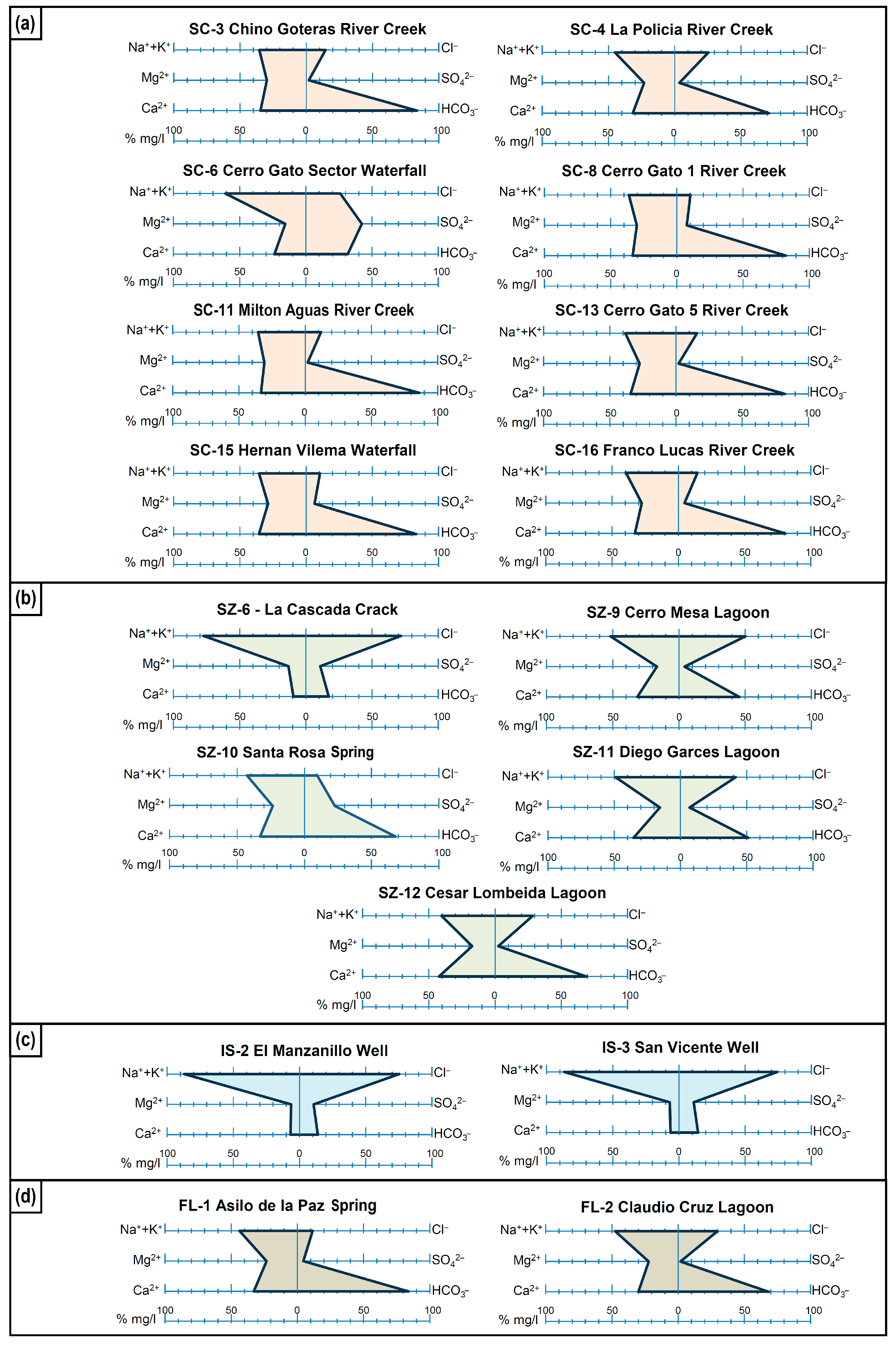
3.4. Hydrochemistry of Natural Water Sources

3.4.1. Stiff Diagram

According to the Stiff Diagram, in San Cristobal, predominantly calcium-bicarbonate type waters mixed with sodium-chloride were identified (SC-3, SC-4, SC-8, SC-11, SC-13, SC-15, SC-16), and sulphate sodium-calcium waters (SC-6). In Santa Cruz, sodium-chloride waters (SZ-6), sodium-calcium bicarbonate waters (SZ-10), and a mixture of calcium-bicarbonate waters with sodium-chloride waters (SZ-9, SZ-11, SZ-12) were identified. Isabela showed sodium-chloride waters. Meanwhile, Floreana showed calcium-bicarbonate waters mixed with chloride-sodium (Figure 4a–d and Table S3).

3.4.2. Piper Diagram

The Piper Diagram revealed predominantly calcium/magnesium-bicarbonate waters (SC-3, SC-4, SC-8, SC-11, SC-13, SC-15, SC-16) and a mixture of sulphate and/or sodium–calcium–chloride waters (SC-6) in San Cristobal. In Santa Cruz, the analysis showed sodium-chloride waters (SZ-6), calcium/magnesium-bicarbonate waters (SZ-10, SZ-12), and a mixture of calcium/magnesium-bicarbonate waters with sodium-chloride waters (SZ-9, SZ-11). Isabela showed sodium-chloride waters. And Floreana showed calcium/magnesium-bicarbonate waters (Figure 5a–d and Table S3).

3.5. Irrigation Water Quality Indices

Table 5 summarises the results of calculating the six water quality indices for irrigation of the seventeen natural sources analysed. In San Cristobal, the irrigation water quality for the parameters %Na, RSC, KR, SAR, MAR, and PI was acceptable in seven of the eight sources analysed; only sample SC-6 resulted unsuitable for irrigation due to its %Na and KR values. In Santa Cruz, the parameters %Na, RSC, KR, SAR, MAR, and PI were in an acceptable range in the sources SZ-9, SZ-10, SZ-11, and SZ-12, while SZ-6 showed inadequate values for %Na, KR, SAR, and MAR, indicating that this source is not suitable for irrigation. In the case of Isabela, both sources turned out unsuitable for irrigation. The sources showed the highest %Na, with values of 87.02% and 86.73%, respectively. Likewise, the KR, SAR, and MAR values were above the appropriate ones. Finally, in Floreana, the calculated indices showed that the water from the two sources analysed is suitable for irrigation.

3.6. SWOT Analysis and Agricultural Sustainability Strategies

According to the natural water sources inventory and the irrigation water quality analysis, a SWOT analysis was carried out (Table 6) to determine the strengths, opportunities, weaknesses, and threats related to the status and management of water resources linked to the agricultural sector of the islands of study.
Based on the SWOT analysis, six strategies were established to guarantee the sustainable use of water resources on the islands, including actions for the management, conservation, and restoration of the islands’ natural water sources in favour of sustainable agriculture. Strategies focus on actions that, starting now, can lay the foundation for future projects.
  • Carry out quarterly monitoring of natural water sources inventoried by the environmental control institutions of the Galapagos Islands (CGREG, MAG, and PNG) in laboratories accredited by the SAE for decision-making regarding water quality in the different seasons of the year.
  • Complete existing hydrological and hydrogeological studies with research projects between government entities, academia, and communities for the study of new natural water sources and the management–restoration of existing sources.
  • Propose the creation of community irrigation boards on the study islands for the integral sustainable management (catchment, distribution, and conservation) of water resources for agricultural use in conjunction with an inter-institutional cooperation network.
  • Promote implementing water sowing and harvesting (WS&H) systems to manage existing water resources effectively.
  • Design a new effluent discharge management system (due to the annual increase in the local population and tourists), considering a sustainable system with circular economy criteria through the study of the current infrastructure and its limitations to control discharges and avoid contamination of natural water sources.
  • Strengthen the agricultural system in the rural areas of the study islands by raising support funds from non-governmental organizations (NGOs) and community participation with national and international entities with sustainable production systems.

4. Discussion

This research contemplated a control–diagnosis of the water quality of the natural sources of the four populated islands of the Galapagos (San Cristobal, Santa Cruz, Isabela, and Floreana). The water’s physicochemical, potentially toxic element content, microbiology, and hydrochemistry were analysed, which are keys for formulating sustainable agricultural development strategies in an island environment.
Permanent and temporary regime surface water sources (streams, springs, waterfalls, cracks, and lagoons) and groundwater (wells) availability were identified. In San Cristobal, superficial and permanent sources associated with streams stood out. In Santa Cruz, surface sources (mainly cracks and lagoons) and wells were identified, with variable availability. In Isabela, the sources corresponded to groundwater sources, with the effects of saline intrusion. And in Floreana, surface sources (spring and lagoon) stood out, with permanent availability. The diversity of these typologies of sources presents the availability of water resources in the archipelago, denoting contamination problems by salinity, faecal coliforms, carbonates, potentially toxic elements, BOD5, and COD, crucial aspects for effective and comprehensive management by local institutions such as MAATE and CGREG. Previous studies considered aspects of pollution at the coastal limit in Santa Cruz due to wastewater’s effects [99].

4.1. Irrigation Water Quality Analysis

The in situ physicochemical analysis indicated that, in general, the water sources of San Cristobal, Santa Cruz, and Floreana are fresh and suitable for irrigation, according to their comparison with the regulations considered. However, Isabela sources (IS-1, IS-2, IS-3, and IS-4) correspond to brackish waters that exceed the limits of the parameters considered for irrigation waters (conductivity and TDS), limiting agriculture due to the effects on crops, soil, and irrigation systems. The physicochemical evaluation of water for irrigation plays an essential role in agricultural management, since irrigation with poor quality water, mainly associated with its high salinity, is capable of negatively impacting the health, properties, and structure of the soil [92,100,101], nutrient availability [102,103], crop productivity [104], and, in many cases, it can also contribute to the deterioration of irrigation systems (e.g., corrosion, obstructions) [105].
Laboratory analysis recognised samples with high carbonate content (SZ-11, SZ-12, SZ-9, FL-1 and FL-2) and potentially toxic elements such as aluminium, iron, and manganese (SZ-10, SZ-11, FL-1) above the permitted limit, possibly associated with the islands’ volcanic origin [106]. On the other hand, high BOD5 values in Santa Cruz (SZ-11 y SZ-12), Isabela (IS-3) and Floreana (FL-2) may be associated with high concentrations of microorganisms in these waters (e.g., bacteria, fungi, or plankton), influencing the availability of oxygen, promoting anaerobic soils that can affect the health of plant roots and their growth [107]. Regarding the COD, its values above the limit in Santa Cruz (SZ-9, SZ-11, SZ-12) and Floreana (FL-1) may be associated with the high content of organic matter, which can lead to the eutrophication of the waters in low oxygen conditions.
According to the hydrochemical analyses (Stiff and Piper) (Table S3, Figure 4 and Figure 5), the predominant waters on the San Cristobal and Floreana islands are bicarbonate, with calcium–magnesium cationic combinations, and in some instances, in a mixture with sodium-chloride water, suggesting contamination of primary meteoric waters with a source of high salinity. Sample SC-6 presents a sulphate and/or sodium–calcium–chloride facie, where the sulphate contribution would be associated with the acquisition of minerals from the geological materials of the island. In Santa Cruz, the water is predominantly chloride with calcium–magnesium cationic combinations in SZ-9 and SZ-11, and sodium in SZ-6, where chloride dominance can be associated with leaching from rocks/soil or due to the influence of domestic effluents [108,109], as well as marine intrusion in the case of SZ-6 [110]. On this island, only SZ-10 and SZ-12 showed patterns of bicarbonate waters; however, they also present a certain degree of contamination with chloride water. On Isabela Island, waters are sodium-chloride type, suggesting contamination of the wells due to saline intrusion, a common phenomenon in aquifers near the sea [28,111,112,113], so effective well management must consider a controlled exploitation system through monitoring not to aggravate the situation.
In the microbiological analysis of the water, the high levels of faecal coliforms in San Cristobal (SC-11, SC-13 and SC-15) would indicate contamination from anthropogenic sources (e.g., septic waste) or animal waste (e.g., excrement), increasing the risk of disease transmission for farmers and consumers of the agricultural products [114]. Considering these parameters in water, environmental and agricultural security issues is essential. One way to use these waters can be through green filter systems, which use the soil as a natural filter for contaminated water for subsequent absorption by the roots of plants [115,116,117].
The analysis of water quality indices for irrigation considered the indices %Na, RSC, KR, SAR, MAR, and PI. Most of the samples analysed (12 of 17) showed that the water quality is acceptable for irrigation. Meanwhile, samples SC-6, SZ-6, IS-2, and IS-3 presented salinity risk associated with their %Na, KR, and SAR values that exceed the acceptable ranges. SZ-6 and IS-3 also showed unacceptable MAR values for agricultural purposes, indicating that these waters can lead to the development of alkaline soils [118].

4.2. Strategies for Agricultural Sustainability

The SWOT analysis made it possible to relate the positive aspects identified in the Galapagos Islands, such as their designations as World Heritage Sites and UNESCO Biosphere Reserves, natural and artificial water sources for agricultural supply, and natural sources with good irrigation quality water. The main weaknesses and threats generally include the lack of an integral base of hydrological and hydrogeological studies, inadequate water management and sanitation, the growth of the local and floating population, climate change effects, and the lack of an integral water management plan. The proposed strategies consider water management, conservation and restoration actions for sustainable agricultural development, contributing to the 2nd [119] and 6th SDG objectives of the 2030 Agenda [120] and the FAO food security guidelines [121].
It is vital to a monitoring network, at least quarterly, to ensure quality water for crops, strengthen hydrological and hydrogeological studies with government–academia–community participation [122,123] for the characterisation, study evolution, quantification, and valorisation of natural water sources [124,125], create irrigation boards for water administration in the agricultural sector, promote WS&H systems or eco-friendly water management practices [126,127,128], and further improvements in the sanitation system and agrarian strengthening with sustainable, productive systems. In short, for sustainability, an articulated system of control, conditioning, and hydraulic structures is essential under an agricultural production system that optimises savings, such as greenhouses.

4.3. Water and Agricultural Development

The scarcity of fresh water in the Galapagos has limited its inhabitants’ agricultural and socioeconomic development. In recent decades, local growth and tourism have severely threatened this resource [75,129]. According to INEC (2015) and the Sustainable Development and Territorial Planning Plan of the Special Regime of Galapagos 2015–2020 [130], basic water coverage in the urban area is high (San Cristobal 89.90%, Santa Cruz 80.90% and Isabela 77.00%); however, the water supply, through natural sources, in the rural areas of the islands is still limited, preventing the maintenance of crops and production throughout the year, compromising food security on the islands [131].
Volcanic islands such as the Galapagos face several challenges for freshwater natural sources formation associated with climatology (irregular rainfall and sectoral variability), hydrography (short and seasonal rivers, rapid runoff), and geology (lithology and porosity of materials, presence of fractures, cracks, or faults), affecting the capacity to retain and release water. Resilient water supply practices for agricultural activities exist on the islands by exploiting wells and rainwater collections (tanks and reservoirs), the latter being the primary water source to cover the need for agricultural water demand [132]. However, there are some challenges. Regarding groundwater, there is a need for detailed hydrogeological studies on populated islands that allow an understanding of the aquifer systems and their interaction with the ocean (salt intrusion), the complex and costly exploration of this resource as it involves transportation of necessary personnel and equipment, and the limitations in drilling due to competition and high abrasion of materials. And, as for the rains, their seasonality and variability in quantity and distribution on all the islands must be studied. In addition, there is the problem of water contamination by natural or anthropogenic sources.
Although several of the natural sources inventoried may be suitable for use in irrigation, it is crucial to maintain sustainable management that does not deplete or contaminate the resource. The reality of Galapagos leads us to think that the use of greenhouses together with controlled irrigation systems, as is being employed in Iceland [133], and with some operations already existing on the islands, is a solution with multiple benefits (use efficiency, conservation and optimization of water resources, productive increase, crop diversification, and energy savings). Furthermore, comprehensive management of surface and groundwater for water supply is essential, which includes WS&H systems [126], fog harvesting to a greater extent, and the desalination of seawater or waters contaminated by saline intrusion for use in agriculture [134], following examples such as those of the Canary Islands [135], southeastern Spain [136] and Israel [137].

5. Conclusions

In this research, a control–diagnosis of water quality was carried out in 34 natural sources of the islands of the Galapagos Archipelago associated with agricultural activity, including streams, springs, waterfalls, cracks, lagoons, and wells, of which all were analysed using in situ physicochemical criteria, and seventeen through laboratory parameters, for the configuration of proposals for water sustainability strategies for the agricultural sector on the islands. Regarding water quality, the predominant hydrochemistry in San Cristobal and Floreana is of the calcium–magnesium bicarbonate type; in Santa Cruz, it is chloride with calcium–magnesium cationic combinations, and in Isabela, it is sodium-chloride. The water quality analysis allows us to conclude that 55.88% of the sources studied are suitable for irrigation, found mainly in San Cristobal and Santa Cruz. In contrast, the remaining 44.12% have problems. In San Cristobal, the southwest zone presents contamination by faecal coliforms (SC-11, SC-13, and SC-15), and the central zone presents saline contamination (SC-6). In Santa Cruz, the problems are related to high values of carbonates, potentially toxic element, BOD5, and COD in the northern area (SZ-9, SZ-10, SZ-11, and SZ-12), while in the south they correspond to saline intrusion (SZ-6). In Isabela, the sources have high salinity in the central and southern areas (IS-1, IS-2, IS-3, and IS-4). In Floreana, problems are related to high potentially toxic element, carbonates, BOD5, and COD rates in the southern part of the agricultural area. It is advisable to prioritise agriculture in regions surrounding the sources detected as favourable. Furthermore, future studies should consider completing the analysis of all inventoried sources, with a view to zoning water sources suitable for irrigation on the four islands.
The study shows the limited groundwater information and the urgent need for meteorological monitoring stations to plan sustainable agriculture in the Galapagos Islands. Geographical, geological factors and anthropogenic activity influence the quantity and quality of the resource. Comprehensive strategies are required for sustainable agricultural development (design–construction of multiple infrastructures, SyCA systems, etc.), considering agro-productive systems in greenhouses for resource savings and water sustainability. A comprehensive approach to governance is essential, with government–academic–social participation that promotes the resilience of agricultural communities, ensuring production and reducing dependence on (agricultural) imports from the continent for the population’s benefit, preventing invasive species entry. The findings of this work constitute a step for planning, decision-making, and policies in favour of efficient water management towards sustainable agricultural development in island environments.

Supplementary Materials

The following supporting information can be downloaded at https://www.mdpi.com/article/10.3390/w16111516/s1: Table S1: Techniques and reference methods of the laboratory tests carried out on water samples from natural sources of the Galapagos; Table S2: Natural water sources inventoried on the four islands with agricultural activity in the Galapagos Archipelago; Table S3: Values and observations regarding the major ions according to Stiff and Piper Diagrams.

Author Contributions

Conceptualization, P.C.-M., F.M.-C., J.B.-B., M.J.-M., E.S.-Z., J.S., J.M.-H., F.J.M.T. and R.E.; data curation, E.S.-Z. and J.S.; formal analysis, P.C.-M., F.M.-C., J.B.-B., M.J.-M., E.S.-Z., J.S., J.M.-H. and F.J.M.T.; funding acquisition, R.E.; investigation, P.C.-M., F.M.-C., J.B.-B., M.J.-M., E.S.-Z., J.S. and J.M.-H.; methodology, P.C.-M., F.M.-C., J.B.-B., M.J.-M., E.S.-Z., J.S. and J.M.-H.; project administration, Á.F.-P. and R.E.; resources, R.E.; software, E.S.-Z., J.S. and J.M.-H.; supervision, P.C.-M., F.M.-C., J.B.-B., F.J.M.T., J.P. and R.E.; validation, P.C.-M., F.M.-C., J.B.-B., M.J.-M., J.M.-H., F.J.M.T., J.P. and Á.F.-P.; visualization, J.S. and J.M.-H.; writing—original draft, P.C.-M., J.B.-B., M.J.-M., E.S.-Z., J.S., J.M.-H. and J.P.; writing—review and editing, P.C.-M., F.M.-C., J.B.-B., M.J.-M., E.S.-Z., J.S. and J.M.-H. All authors have read and agreed to the published version of the manuscript.

Funding

This research was funded by the project “Preparation of studies to formulate the irrigation and drainage plan of Galapagos” of the Consejo de Gobierno del Régimen Especial Galápagos (CGREG) and the Centro de Investigaciones Rurales (CIR) of ESPOL Polytechnic University with code CIR-10-2021.

Data Availability Statement

The original contributions presented in the study are included in the article/Supplementary Material, further inquiries can be directed to the corresponding author.

Acknowledgments

We thank the technicians of Centro de Investigaciones Rurales (CIR) and Galapagos National Park (GNP) for all the logistics and operations support during the sampling collection campaign in the Galapagos Islands. Also, we thank the academic project support “Registry of sites of geological interest in Ecuador for sustainable development strategies” of the ESPOL Polytechnic University with code CIPAT-004-2024.

Conflicts of Interest

The authors declare no conflicts of interest.

References

  1. Hoekstra, A.Y. A Critique on the Water-Scarcity Weighted Water Footprint in LCA. Ecol. Indic. 2016, 66, 564–573. [Google Scholar] [CrossRef]
  2. Huang, Z.; Hejazi, M.; Li, X.; Tang, Q.; Vernon, C.; Leng, G.; Liu, Y.; Döll, P.; Eisner, S.; Gerten, D.; et al. Reconstruction of Global Gridded Monthly Sectoral Water Withdrawals for 1971–2010 and Analysis of Their Spatiotemporal Patterns. Hydrol. Earth Syst. Sci. 2018, 22, 2117–2133. [Google Scholar] [CrossRef]
  3. USGS. The Distribution of Water on, in, and above the Earth. Available online: https://www.usgs.gov/media/images/distribution-water-and-above-earth (accessed on 5 October 2023).
  4. Mishra, B.; Kumar, P.; Saraswat, C.; Chakraborty, S.; Gautam, A. Water Security in a Changing Environment: Concept, Challenges and Solutions. Water 2021, 13, 490. [Google Scholar] [CrossRef]
  5. Li, P.; Wu, J. Drinking Water Quality and Public Health. Expo. Health 2019, 11, 73–79. [Google Scholar] [CrossRef]
  6. Morante-Carballo, F.; Montalván-Burbano, N.; Quiñonez-Barzola, X.; Jaya-Montalvo, M.; Carrión-Mero, P. What Do We Know about Water Scarcity in Semi-Arid Zones? A Global Analysis and Research Trends. Water 2022, 14, 2685. [Google Scholar] [CrossRef]
  7. Baggio, G.; Qadir, M.; Smakhtin, V. Freshwater Availability Status across Countries for Human and Ecosystem Needs. Sci. Total Environ. 2021, 792, 148230. [Google Scholar] [CrossRef]
  8. Jiang, Y. China’s Water Security: Current Status, Emerging Challenges and Future Prospects. Environ. Sci. Policy 2015, 54, 106–125. [Google Scholar] [CrossRef]
  9. The World Bank Group Water. Available online: https://www.worldbank.org/en/topic/water/overview#1 (accessed on 17 November 2023).
  10. UN. Water Summary Progress Update 2021: SDG 6—Water and Sanitation for All; UN: New York, NY, USA, 2021; p. 58.
  11. Asian Development Bank. Asian Water Development Outlook (AWDO) Strengthening Water Security in Asia and the Pacific; Asian Development Bank: Mandaluyong, Philippines, 2020. [Google Scholar]
  12. World Economic Forum. The Global Risks Report 2020 Insight Report, 15th ed.; World Economic Forum: Cologny, Switzerland, 2020. [Google Scholar]
  13. Ricart, S.; Rico-Amorós, A.M. Constructed Wetlands to Face Water Scarcity and Water Pollution RRisks: Learning from Farmers’ Perception in Alicante, Spain. Water 2021, 13, 2431. [Google Scholar] [CrossRef]
  14. Liu, J.; Yang, H.; Gosling, S.N.; Kummu, M.; Flörke, M.; Pfister, S.; Hanasaki, N.; Wada, Y.; Zhang, X.; Zheng, C.; et al. Water Scarcity Assessments in the Past, Present, and Future. Earth’s Futur. 2017, 5, 545–559. [Google Scholar] [CrossRef]
  15. Tzanakakis, V.A.; Paranychianakis, N.V.; Angelakis, A.N. Water Supply and Water Scarcity. Water 2020, 12, 2347. [Google Scholar] [CrossRef]
  16. Yao, Y.; Andrews, C.; Zheng, Y.; He, X.; Babovic, V.; Zheng, C. Development of Fresh Groundwater Lens in Coastal Reclaimed Islands. J. Hydrol. 2019, 573, 365–375. [Google Scholar] [CrossRef]
  17. Holding, S.; Allen, D.M.; Foster, S.; Hsieh, A.; Larocque, I.; Klassen, J.; Van Pelt, S.C. Groundwater Vulnerability on Small Islands. Nat. Clim. Chang. 2016, 6, 1100–1103. [Google Scholar] [CrossRef]
  18. Bailey, R.T.; Barnes, K.; Wallace, C.D. Predicting Future Groundwater Resources of Coral Atoll Islands. Hydrol. Process. 2016, 30, 2092–2105. [Google Scholar] [CrossRef]
  19. Post, V.E.A.; Galvis, S.C.; Sinclair, P.J.; Werner, A.D. Evaluation of Management Scenarios for Potable Water Supply Using Script-Based Numerical Groundwater Models of a Freshwater Lens. J. Hydrol. 2019, 571, 843–855. [Google Scholar] [CrossRef]
  20. Tzanakakis, V.; Angelakis, A.; Paranychianakis, N.; Dialynas, Y.; Tchobanoglous, G. Challenges and Opportunities for Sustainable Management of Water Resources in the Island of Crete, Greece. Water 2020, 12, 1538. [Google Scholar] [CrossRef]
  21. Kourgialas, N.N.; Karatzas, G.P.; Dokou, Z.; Kokorogiannis, A. Groundwater Footprint Methodology as Policy Tool for Balancing Water Needs (Agriculture & Tourism) in Water Scarce Islands—The Case of Crete, Greece. Sci. Total Environ. 2018, 615, 381–389. [Google Scholar] [CrossRef] [PubMed]
  22. Steiakakis, E.; Vavadakis, D.; Kritsotakis, M.; Voudouris, K.; Anagnostopoulou, C. Drought Impacts on the Fresh Water Potential of a Karst Aquifer in Crete, Greece. Environ. Earth Sci. 2016, 75, 507. [Google Scholar] [CrossRef]
  23. Kourgialas, N.N.; Karatzas, G.P. Groundwater Contamination Risk Assessment in Crete, Greece, Using Numerical Tools within a GIS Framework. Hydrol. Sci. J. 2015, 60, 111–132. [Google Scholar] [CrossRef]
  24. Rosales-Asensio, E.; García-Moya, F.J.; González-Martínez, A.; Borge-Diez, D.; de Simón-Martín, M. Stress Mitigation of Conventional Water Resources in Water-Scarce Areas through the Use of Renewable Energy Powered Desalination Plants: An Application to the Canary Islands. Energy Rep. 2020, 6, 124–135. [Google Scholar] [CrossRef]
  25. García-Rubio, M.A.; Guardiola, J. Desalination in Spain: A Growing Alternative for Water Supply. Int. J. Water Resour. Dev. 2012, 28, 171–186. [Google Scholar] [CrossRef]
  26. Dallavalle, E.; Cipolletta, M.; Casson Moreno, V.; Cozzani, V.; Zanuttigh, B. Towards Green Transition of Touristic Islands through Hybrid Renewable Energy Systems. A Case Study in Tenerife, Canary Islands. Renew. Energy 2021, 174, 426–443. [Google Scholar] [CrossRef]
  27. UN. International Decade for Action ‘Water for Life’ 2005–2015. Available online: https://www.un.org/waterforlifedecade/ (accessed on 25 November 2023).
  28. Carrión-Mero, P.; Montalván, F.J.; Morante-Carballo, F.; Heredia, J.; Elorza, F.J.; Solórzano, J.; Aguilera, H. Hydrochemical and Isotopic Characterization of the Waters of the Manglaralto River Basin (Ecuador) to Contribute to the Management of the Coastal Aquifer. Water 2021, 13, 537. [Google Scholar] [CrossRef]
  29. Goethals, P.; Volk, M. Implementing Sustainability in Water Management: Are We Still Dancing in the Dark? Sustain. Water Qual. Ecol. 2016, 7, 1–4. [Google Scholar] [CrossRef]
  30. Teixeira, Z.; Teixeira, H.; Marques, J.C. Systematic Processes of Land Use/Land Cover Change to Identify Relevant Driving Forces: Implications on Water Quality. Sci. Total Environ. 2014, 470–471, 1320–1335. [Google Scholar] [CrossRef] [PubMed]
  31. Forio, M.A.E.; Mouton, A.; Lock, K.; Boets, P.; Nguyen, T.H.T.; Damanik Ambarita, M.N.; Musonge, P.L.S.; Dominguez-Granda, L.; Goethals, P.L.M. Fuzzy Modelling to Identify Key Drivers of Ecological Water Quality to Support Decision and Policy Making. Environ. Sci. Policy 2017, 68, 58–68. [Google Scholar] [CrossRef]
  32. Hauck, J.; Winkler, K.J.; Priess, J.A. Reviewing Drivers of Ecosystem Change as Input for Environmental and Ecosystem Services Modelling. Sustain. Water Qual. Ecol. 2015, 5, 9–30. [Google Scholar] [CrossRef]
  33. He, H.; Cheng, Y.; Zhou, J.; Keo, S.; Goethals, P. Monitoring and Assessment of Water Quality and Ecology. Sustain. Water Qual. Ecol. 2014, 3–4, 1–2. [Google Scholar] [CrossRef]
  34. Uddin, M.G.; Nash, S.; Olbert, A.I. A Review of Water Quality Index Models and Their Use for Assessing Surface Water Quality. Ecol. Indic. 2021, 122, 107218. [Google Scholar] [CrossRef]
  35. Gleick, P.H.; Cooley, H. Freshwater Scarcity. Annu. Rev. Environ. Resour. 2021, 46, 319–348. [Google Scholar] [CrossRef]
  36. UN. Goal 6: Ensure Availability and Sustainable Management of Water and Sanitation for All. Available online: https://unstats.un.org/sdgs/report/2017/goal-06/ (accessed on 25 November 2023).
  37. UNESCO-WHC. Galápagos Islands. Available online: https://whc.unesco.org/en/list/1/ (accessed on 25 November 2023).
  38. UNESCO. Man and the Biosphere Programme (MAB)-Galápagos. Available online: https://www.unesco.org/en/mab/galapagos#:~:text=La%20Reserva%20de%20la%20Biosfera,Ecuador%20en%20la%20isla%20Isabela (accessed on 25 November 2023).
  39. Carrión-Mero, P.; Sánchez-Zambrano, E.; Mata-Perelló, J.; Jaya-Montalvo, M.; Herrera-Franco, G.; Berrezueta, E.; Espinel, R.L.; Baque, M.; Morante-Carballo, F. Geosites Assessment in a Volcanic Hotspot Environment and Its Impact on Geotourism, Santa Cruz-Galapagos Islands, Ecuador. Int. J. Geoheritage Park. 2024, 12, 147–167. [Google Scholar] [CrossRef]
  40. Informe Anual de Visitantes a Las Áreas Protegidas de Galápagos Del Año 2023; Dirección del Parque Nacional Galápagos: Santa Cruz, Ecuador, 2024.
  41. Mateus, C.; Guerrero, C.A.; Quezada, G.; Lara, D.; Ochoa-Herrera, V. An Integrated Approach for Evaluating Water Quality between 2007–2015 in Santa Cruz Island in the Galapagos Archipelago. Water 2019, 11, 937. [Google Scholar] [CrossRef]
  42. Re, V.; Rizzi, J.; Tuci, C.; Tringali, C.; Mancin, M.; Mendieta, E.; Marcomini, A. Challenges and Opportunities of Water Quality Monitoring and Multi-Stakeholder Management in Small Islands: The Case of Santa Cruz, Galápagos (Ecuador). Environ. Dev. Sustain. 2023, 25, 3867–3891. [Google Scholar] [CrossRef]
  43. Riascos-Flores, L.; Bruneel, S.; Van der Heyden, C.; Deknock, A.; Van Echelpoel, W.; Forio, M.A.E.; De Saeyer, N.; Vanden Berghe, W.; Spanoghe, P.; Bermudez, R.; et al. Polluted Paradise: Occurrence of Pesticide Residues within the Urban Coastal Zones of Santa Cruz and Isabela (Galapagos, Ecuador). Sci. Total Environ. 2021, 763, 142956. [Google Scholar] [CrossRef] [PubMed]
  44. Vernaza, W.; Pozo, R.; Mateus, M.C.; Quiroga, D.; Stewart, J.; Thompson, A.; Raheem, N.; Ochoa-Herrera, V. “Agua Para Galápagos”: Un Programa de Monitoreo de La Calidad Del Agua En Las Islas Galápagos. Esferas 2021, 2, 26. [Google Scholar] [CrossRef]
  45. Reyes, M.; Petričić, A.; Trifunović, N.; Sharma, S. Water Management Strategies Using Multi-Criteria Decision Analysis in Santa Cruz Island (Galapagos Archipelago). Guigoz. Sci. Rev. 2019, 5, 112–123. [Google Scholar] [CrossRef]
  46. Grube, A.M.; Stewart, J.R.; Ochoa-Herrera, V. The Challenge of Achieving Safely Managed Drinking Water Supply on San Cristobal Island, Galápagos. Int. J. Hyg. Environ. Health 2020, 228, 113547. [Google Scholar] [CrossRef]
  47. Van Echelpoel, W.; Forio, M.A.E.; Van der Heyden, C.; Bermúdez, R.; Ho, L.; Moncayo, A.M.R.; Narea, R.N.P.; Granda, L.E.D.; Sanchez, D.; Goethals, P.L.M. Spatial Characteristics and Temporal Evolution of Chemical and Biological Freshwater Status as Baseline Sssessment on the Tropical Island San Cristóbal (Galapagos, Ecuador). Water 2019, 11, 880. [Google Scholar] [CrossRef]
  48. Gerhard, W.A.; Choi, W.S.; Houck, K.M.; Stewart, J.R. Water Quality at Points-of-Use in the Galapagos Islands. Int. J. Hyg. Environ. Health 2017, 220, 485–493. [Google Scholar] [CrossRef]
  49. Badhwa, N.; Fejfar, D.; Pozo, R.; Nicholas, K.; Grube, A.; Stewart, J.; Thompson, A.; Ochoa-Herrera, V. Water Quality and Access in Isabela: Results from a Household Water Survey. In Water, Food and Human Health in the Galapagos, Ecuador. Social and Ecological Interactions in the Galapagos Islands; Springer: Berlin/Heidelberg, Germany, 2022; pp. 57–74. [Google Scholar]
  50. Sampedro, C.; Pizzitutti, F.; Quiroga, D.; Walsh, S.J.; Mena, C.F. Food Supply System Dynamics in the Galapagos Islands: Agriculture, Livestock and Imports. Renew. Agric. Food Syst. 2020, 35, 234–248. [Google Scholar] [CrossRef]
  51. Burke, A. The Crossroads of Ecotourism Dependency, Food Security and a Global Pandemic in Galápagos, Ecuador. Sustainability 2021, 13, 13094. [Google Scholar] [CrossRef]
  52. INEC-Ecuador Análisis de Resultados Definitivos Censo de Población y Vivienda Galápagos. 2015. Available online: https://www.ecuadorencifras.gob.ec/documentos/web-inec/Poblacion_y_Demografia/CPV_Galapagos_2015/Analisis_Galapagos%202015.pdf (accessed on 29 November 2023).
  53. Plan de Manejo de Las Áreas Protegidas de Galápagos Para El Buen Vivir; Dirección del Parque Nacional Galápagos: Galápagos, Ecuador, 2014.
  54. INEC. Censo de Población y Vivienda-Galápagos. Available online: https://www.ecuadorencifras.gob.ec/documentos/web-inec/Poblacion_y_Demografia/CPV_Galapagos_2015/Presentacion_CPVG15.pdf (accessed on 29 November 2023).
  55. Villagómez, D.R.; Toomey, D.R.; Hooft, E.E.E.; Solomon, S.C. Upper Mantle Structure beneath the Galápagos Archipelago from Surface Wave Tomography. J. Geophys. Res. Solid Earth 2007, 112, B07303. [Google Scholar] [CrossRef]
  56. Simkin, T. Geology of Galapagos. Biol. J. Linn. Soc. 1984, 21, 61–75. [Google Scholar] [CrossRef]
  57. Harpp, K.S.; Wanless, V.D.; Otto, R.H.; Hoernle, K.; Werner, R. The Cocos and Carnegie Aseismic Ridges: A Trace Element Record of Long-Term Plume–Spreading Center Interaction. J. Petrol. 2005, 46, 109–133. [Google Scholar] [CrossRef]
  58. Toulkeridis, T. Volcanic Galápagos Volcánico; Centro de Geología, Volcanología y Geodinámica, Escuela Politécnica del Ejército: Sangolquí, Ecuador, 2011. [Google Scholar]
  59. Glynn, P.W.; Feingold, J.S.; Baker, A.; Banks, S.; Baums, I.B.; Cole, J.; Colgan, M.W.; Fong, P.; Glynn, P.J.; Keith, I.; et al. State of Corals and Coral Reefs of the Galápagos Islands (Ecuador): Past, Present and Future. Mar. Pollut. Bull. 2018, 133, 717–733. [Google Scholar] [CrossRef] [PubMed]
  60. Paltán, H.A.; Benitez, F.L.; Rosero, P.; Escobar-Camacho, D.; Cuesta, F.; Mena, C.F. Climate and Sea Surface Trends in the Galapagos Islands. Sci. Rep. 2021, 11, 14465. [Google Scholar] [CrossRef]
  61. The World Bank Group Ecuador Climatology. Available online: https://climateknowledgeportal.worldbank.org/country/ecuador/climate-data-historical (accessed on 27 November 2023).
  62. Larrea, O.I.; Di Carlo, G. Climate Change Vulnerability Assessment of the Galápagos Islands; WWF and Conservation International: Arlington, VA, USA, 2011; p. 116. [Google Scholar]
  63. Trueman, M.; D’Ozouville, N. Characterizing the Galapagos Terrestrial Climate in the Face of Global Climate Change. Galapagos Res. 2010, 67, 26–37. [Google Scholar]
  64. Adelinet, M.; Fortin, J.; D’Ozouville, N.; Violette, S. The Relationship between Hydrodynamic Properties and Weathering of Soils Derived from Volcanic Rocks, Galapagos Islands (Ecuador). Environ. Geol. 2008, 56, 45–58. [Google Scholar] [CrossRef]
  65. Stoops, G. A Micromorphological Evaluation of Pedogenesis on Isla Santa Cruz (Galápagos). Span. J. Soil Sci. 2013, 3, 14–37. [Google Scholar] [CrossRef]
  66. Rhea, S.; Camacho, B.E.; Amoriello, C.W.; Correa, M.; Lewbart, G.A.; Cruz, M.; Vélez, A.; Castillo, P.; Pairis-Garcia, M. Assessing Livestock Production Practices on Small-Scale Multi-Species Farms Located on Floreana Island, Galápagos Islands. Animals 2023, 13, 686. [Google Scholar] [CrossRef]
  67. Klassen, C. El Junco, La Única Laguna de Agua Dulce de Galápagos, Nuevamente Libre de Especies Invasoras. Available online: https://www.metropolitantouring.com/noticias-ecuadory-%0Agalapagos/el-junco-la-unica-laguna-de-agua-dulce-de-galapagos-nuevamente-libre-de-especies-invasoras (accessed on 27 November 2023).
  68. Jaramillo Díaz, P.; Calle-Loor, A.; Velasco, N.; Cevallos, D. Water-Saving Technologies in Galapagos Agriculture: A Step towards Sustainability. Horticulturae 2023, 9, 683. [Google Scholar] [CrossRef]
  69. Informe de Componente Ambiental. Elaboración de Estudios para Formular el Plan de Riego y Drenaje de Galápagos; Internal Report; Centro de Investigación y Proyectos Aplicados a las Ciencias de la Tierra (CIPAT): Guayaquil, Ecuador, 2022. [Google Scholar]
  70. Centro de Investigaciones Rurales (CIR). Estudios Para Formular el Plan de Riego y Drenaje en las Islas Galápagos; Internal Report; Escuela Superior Politécncia del Litoral: Guayaquil, Ecuador, 2022. [Google Scholar]
  71. Centro de Investigaciones Rurales (CIR). Estudios y Diseños Definitivos del Sistema de Riego Comunitario Camote-Cascajo del Cantón Santa Cruz, Galápagos; Internal Report; Centro de Investigaciones Rurales: Guayaquil, Ecuador, 2023. [Google Scholar]
  72. McBirney, A.R.; Williams, H. Geology and Petrology of the Galápagos Islands. In GSA Memoirs; The Geological Society of America: Boulder, CO, USA, 1969; pp. 1–197. [Google Scholar]
  73. Warrier, R.B.; Castro, M.C.; Hall, C.M. Recharge and Source-Water Insights from the Galapagos Islands Using Noble Gases and Stable Isotopes. Water Resour. Res. 2012, 48, W03508. [Google Scholar] [CrossRef]
  74. Cazorla, M.; Herrera, E. Air Quality in the Galapagos Islands: A Baseline View from Remote Sensing and in Situ Measurements. Meteorol. Appl. 2020, 27, e1878. [Google Scholar] [CrossRef]
  75. Reyes, M.; Trifunović, N.; Sharma, S.; Behzadian, K.; Kapelan, Z.; Kennedy, M. Mitigation Options for Future Water Scarcity: A Case Study in Santa Cruz Island (Galapagos Archipelago). Water 2017, 9, 597. [Google Scholar] [CrossRef]
  76. Haukeland, J.V.; Daugstad, K.; Vistad, O.I. Harmony or Conflict? A Focus Group Study on Traditional Use and Tourism Development in and around Rondane and Jotunheimen National Parks in Norway. Scand. J. Hosp. Tour. 2011, 11, 13–37. [Google Scholar] [CrossRef]
  77. INEN NTE-INEN 2169; Agua. Calidad Del Agua. Muestreo, Manejo y Conservación de Muestras. Instituto Ecuatoriano de Normalizacion: Quito, Ecuador, 2013.
  78. INEN NTE-INEN 2176; Agua.Calidad Del Agua. Muestreo. Técncias de Muestreo. Instituto Ecuatoriano de Normalizacion: Quito, Ecuador, 1998.
  79. ISO 5667-3:2012; Water Quality Sampling Part 3: Guidance on the Preservation and Handling of Water Samples. International Organization for Standardization: Geneva, Switzerland, 2012. Available online: https://www.iso.org/standard/33486.html (accessed on 6 March 2024).
  80. ISO 5667-1:2020; Water Quality Sampling Part 1: Guidance on the Design of Sampling Programmes and Sampling Techniques. International Organization for Standardization: Geneva, Switzerland, 2020. Available online: https://www.iso.org/standard/72369.html (accessed on 6 March 2024).
  81. INEN NTE INEN-ISO/IEC 17025; Requisitos Generales Para La Competencia de Los Laboratorios de Ensayo y Calibración. Instituto Ecuatoriano de Normalizacion: Quito, Ecuador, 2018.
  82. Ministerio del Ambiente-Agua y Transición Ecológica (MAATE). Norma de Calidad Ambiental y de Descarga de Efluentes: Recurso Agua. Available online: https://faolex.fao.org/docs/pdf/ecu155128.pdf (accessed on 10 February 2024).
  83. Ministerio del Ambiente Perú. Decreto Supremo No 004-2017-MINAM—Estándares de Calidad Ambiental (ECA) Para Agua y Disposiciones Complementarias. 2017. Available online: https://www.minam.gob.pe/wp-content/uploads/2017/06/DS-004-2017-MINAM.pdf (accessed on 10 February 2024).
  84. NCh 1.333; Requisitos de Calidad del Agua para Diferentes Usos. Instituto Nacional de Normalización de Chile: Santiago, Chile, 1987.
  85. Stiff, H.A. The Interpretation of Chemical Water Analysis by Means of Patterns. J. Pet. Technol. 1951, 3, 15. [Google Scholar] [CrossRef]
  86. Piper, A.M. A Graphic Procedure in the Geochemical Interpretation of Water-Analyses. Trans. Am. Geophys. Union 1944, 25, 914. [Google Scholar] [CrossRef]
  87. Pivić, R.; Maksimović, J.; Dinić, Z.; Jaramaz, D.; Majstorović, H.; Vidojević, D.; Stanojković-Sebić, A. Hydrochemical Assessment of Water Used for Agricultural Soil Irrigation in the Water Area of the Three Morava Rivers in the Republic of Serbia. Agronomy 2022, 12, 1177. [Google Scholar] [CrossRef]
  88. Shah, B.; Kansara, B.; Shankar, J.; Soni, M.; Bhimjiyani, P.; Bhanushali, T.; Shah, M.; Sircar, A. Reckoning of Water Quality for Irrigation and Drinking Purposes in the Konkan Geothermal Provinces, Maharashtra, India. Groundw. Sustain. Dev. 2019, 9, 100247. [Google Scholar] [CrossRef]
  89. Moreno Merino, L.; De la Losa Román, A.; Romero Prados, A.; Carro Martín, S. Interpretación de Análisis Químicos de Aguas Subterráneas Mediante La Hoja INAQUAS; Instituto Geológico y Minero de España, Ed.; Instituto Geológico y Minero de España: Madrid, Spain, 2006; ISBN 978-84-9138-019-1. [Google Scholar]
  90. Vazquez-Suñé, E.; Serrano-Juan, A. Easy_Quim v. 5.0. 2015. Available online: https://h2ogeo.upc.edu/es/software-hidrologiasubterrania/11-software-hidrologia-subterrania/42-easy-quim (accessed on 17 November 2023).
  91. Hou, Q.; Pan, Y.; Zeng, M.; Wang, S.; Shi, H.; Huang, C.; Peng, H. Assessment of Groundwater Hydrochemistry, Water Quality, and Health Risk in Hainan Island. China. Sci. Rep. 2023, 13, 12104. [Google Scholar] [CrossRef]
  92. Rengasamy, P. Irrigation Water Quality and Soil Structural Stability: A Perspective with Some New Insights. Agronomy 2018, 8, 72. [Google Scholar] [CrossRef]
  93. Wilcox, L.W. Classification and Use of Irrigation Waters; U.S. Department of Agriculture: Washington, DC, USA, 1955. [Google Scholar]
  94. Nagaraju, A.; Suresh, S.; Killham, K.; Hudson-Edwards, K. Hydrogeochemistry of Waters of Mangampeta Barite Mining Area, Cuddapah Basin, Andhra Pradesh, India. Turkish J. Eng. Environ. Sci. 2006, 30, 203–219. [Google Scholar]
  95. Kelley, W.P. Permissible Composition and Concentration of Irrigation Water. Trans. Am. Soc. Civ. Eng. 1941, 106, 849–855. [Google Scholar] [CrossRef]
  96. Richards, L.A. Diagnosis and Improvement of Saline and Alkaline Soils; United States Department of Agriculture, Soil and Water Conservation Research Branch, Agricultural Research Service: Washington, DC, USA, 1954; Volume 18. [Google Scholar]
  97. Doneen, L.D. The Influence of Crop and Soil on Percolating Water. In Biennial Conference on Groundwater Recharge; Ground Water Recharge Laboratory, Southwest Branch, Soil and Water Conservation Research Division: Fresno, CA, USA, 1962; pp. 156–163. [Google Scholar]
  98. Okoli, C.; Pawlowski, S.D. The Delphi Method as a Research Tool: An Example, Design Considerations and Applications. Inf. Manag. 2004, 42, 15–29. [Google Scholar] [CrossRef]
  99. Centro de Investigación y Proyectos Aplicados a las Ciencias de la Tierra (CIPAT). Programa de la Consultoría para Identificar las Fuentes de Contaminación en Agua y Suelo en el Cantón Santa Cruz y Elaborar su Plano de Manejo Ambiental; CIPAT: Guayaquil, Ecuador, 2011. [Google Scholar]
  100. Huang, C.H.; Xue, X.; Wang, T.; De Mascellis, R.; Mele, G.; You, Q.G.; Peng, F.; Tedeschi, A. Effects of Saline Water Irrigation on Soil Properties in Northwest China. Environ. Earth Sci. 2011, 63, 701–708. [Google Scholar] [CrossRef]
  101. Rahimi, L.; Amanipoor, H.; Battaleb-Looie, S. Effect of Salinity of Irrigation Water on Soil Properties (Abadan Plain, SW Iran). Geocarto Int. 2021, 36, 1884–1903. [Google Scholar] [CrossRef]
  102. Fageria, N.K.; Gheyi, H.R.; Moreira, A. Nutrient Bioavailability in Salt Affected Soils. J. Plant Nutr. 2011, 34, 945–962. [Google Scholar] [CrossRef]
  103. Alva, A.K.; Syvertsen, J.P. Irrigation Water Salinity Affects Soil Nutrient Distribution, Root Density, and Leaf Nutrient Levels of Citrus under Drip Fertigation 1. J. Plant Nutr. 1991, 14, 715–727. [Google Scholar] [CrossRef]
  104. Cheng, M.; Wang, H.; Fan, J.; Wang, X.; Sun, X.; Yang, L.; Zhang, S.; Xiang, Y.; Zhang, F. Crop Yield and Water Productivity under Salty Water Irrigation: A Global Meta-Analysis. Agric. Water Manag. 2021, 256, 107105. [Google Scholar] [CrossRef]
  105. Lili, Z.; Peiling, Y.; Wengang, Z.; Yunkai, L.; Yu, L.; Chong, Z. Effects of Water Salinity on Emitter Clogging in Surface Drip Irrigation Systems. Irrig. Sci. 2021, 39, 209–222. [Google Scholar] [CrossRef]
  106. Harpp, K.S.; Geist, D.J. The Galápagos Islands. In Encyclopedia of Geology; Elsevier: Amsterdam, The Netherlands, 2021; pp. 659–673. [Google Scholar]
  107. Bartholomeus, R.P.; Witte, J.-P.M.; van Bodegom, P.M.; van Dam, J.C.; Aerts, R. Critical Soil Conditions for Oxygen Stress to Plant Roots: Substituting the Feddes-Function by a Process-Based Model. J. Hydrol. 2008, 360, 147–165. [Google Scholar] [CrossRef]
  108. Allbed, A.; Kumar, L.; Aldakheel, Y.Y. Assessing Soil Salinity Using Soil Salinity and Vegetation Indices Derived from IKONOS High-Spatial Resolution Imageries: Applications in a Date Palm Dominated Region. Geoderma 2014, 230–231, 1–8. [Google Scholar] [CrossRef]
  109. Kumar, S.; Nakajima, T.; Mbonimpa, E.G.; Gautam, S.; Somireddy, U.R.; Kadono, A.; Lal, R.; Chintala, R.; Rafique, R.; Fausey, N. Long-Term Tillage and Drainage Influences on Soil Organic Carbon Dynamics, Aggregate Stability and Corn Yield. Soil Sci. Plant Nutr. 2014, 60, 108–118. [Google Scholar] [CrossRef]
  110. Werner, A.D.; Bakker, M.; Post, V.E.A.; Vandenbohede, A.; Lu, C.; Ataie-Ashtiani, B.; Simmons, C.T.; Barry, D.A. Seawater Intrusion Processes, Investigation and Management: Recent Advances and Future Challenges. Adv. Water Resour. 2013, 51, 3–26. [Google Scholar] [CrossRef]
  111. Javier Montalván, F.; Solórzano, J.; Sánchez-Zambrano, E.; Bailón-Piguave, I.; Tomalá-Guale, H.; Loor-Flores de Valgas, C.; Carrión-Mero, P. Vulnerability to Contamination of the Olón Aquifer Using the GOD Method, Olón-Ecuador. In Sustainability in Practice; Springer: Cham, Switzerland, 2023; pp. 525–544. [Google Scholar]
  112. Gopinath, S.; Srinivasamoorthy, K.; Saravanan, K.; Suma, C.S.; Prakash, R.; Senthilnathan, D.; Chandrasekaran, N.; Srinivas, Y.; Sarma, V.S. Modeling Saline Water Intrusion in Nagapattinam Coastal Aquifers, Tamilnadu, India. Model. Earth Syst. Environ. 2016, 2, 2. [Google Scholar] [CrossRef]
  113. Nadjla, B.; Abdellatif, D.; Assia, S. Mapping of the Groundwater Vulnerability to Saline Intrusion Using the Modified GALDIT Model (Case: The Ain Temouchent Coastal Aquifer, (North-Western Algeria)). Environ. Earth Sci. 2021, 80, 319. [Google Scholar] [CrossRef]
  114. Steele, M.; Odumeru, J. Irrigation Water as Source of Foodborne Pathogens on Fruit and Vegetables. J. Food Prot. 2004, 67, 2839–2849. [Google Scholar] [CrossRef] [PubMed]
  115. Morante-Carballo, F.; Brito-Marcatoma, L.; Carrión-Mero, P.; Aguilar-Aguilar, M.; Ramírez-Tumbaco, J. Urban Wastewater Treatment Through a System of Green Filters in the Montañita Commune, Santa Elena, Ecuador. In Water and Society V; WIT Transactions on Ecology and the Environment; WIT Press: Southampton, UK, 2019; pp. 233–249. [Google Scholar]
  116. Alvarez Vega, F. Filtros Verdes. Un Sistema de Depuración Ecológico. Ing. Hidráulica Ambient. 2002, 23, 25–28. [Google Scholar]
  117. Chen, X.; Luo, A.C.; Sato, K.; Wakatsuki, T.; Masunaga, T. An Introduction of a Multi-soil-layering System: A Novel Green Technology for Wastewater Treatment in Rural Areas. Water Environ. J. 2009, 23, 255–262. [Google Scholar] [CrossRef]
  118. Qadir, M.; Schubert, S.; Oster, J.D.; Sposito, G.; Minhas, P.S.; Cheraghi, S.A.M.; Murtaza, G.; Mirzabaev, A.; Saqib, M. High-magnesium Waters and Soils: Emerging Environmental and Food Security Constraints. Sci. Total Environ. 2018, 642, 1108–1117. [Google Scholar] [CrossRef]
  119. United Nations. Department of Economic and Social Affairs. Sustainable Development. SDG Goal 2. Available online: https://sdgs.un.org/goals/goal2 (accessed on 10 January 2024).
  120. United Nations. Sustainable Development. Department of Economic and Social Affairs. SDG Goal 6. Available online: https://sdgs.un.org/goals/goal6 (accessed on 10 January 2024).
  121. FAO. World Food Security: A Reappraisal of the Concepts and Approaches; FAO: Rome, Italy, 1983. [Google Scholar]
  122. Carrión-Mero, P.; Morante-Carballo, F.; Herrera-Franco, G.; Jaya-Montalvo, M.; Rodríguez, D.; Loor-Flores de Valgas, C.; Berrezueta, E. Community-University Partnership in Water Education and Linkage Process. Study Case: Manglaralto, Santa Elena, Ecuador. Water 2021, 13, 25. [Google Scholar] [CrossRef]
  123. Herrera-Franco, G.; Carrión-Mero, P.; Alvarado-Macancela, N. Participatory Process for Local Development: Sustainability of Water Resources in Rural Communities: Case Manglaralto-Santa Elena, Ecuador. In Handbook of Sustainability Science and Research. World Sustainability Series; Leal Filho, W., Ed.; Springer: Cham, Switzerland, 2018; pp. 663–676. [Google Scholar]
  124. Herrera-Franco, G.; Carrión-Mero, P.; Montalván-Burbano, N.; Mora-Frank, C.; Berrezueta, E. Bibliometric Analysis of Groundwater’s Life Cycle Assessment Research. Water 2022, 14, 1082. [Google Scholar] [CrossRef]
  125. Morante-Carballo, F.; Gurumendi-Noriega, M.; Cumbe-Vásquez, J.; Bravo-Montero, L.; Carrión-Mero, P. Georesources as an Alternative for Sustainable Development in COVID-19 Times—A Study Case in Ecuador. Sustainability 2022, 14, 7856. [Google Scholar] [CrossRef]
  126. Martos-Rosillo, S.; Durán, A.; Castro, M.; Vélez, J.J.; Herrera, G.; Martín-Civantos, J.M.; Mateos, L.; Durán, J.J.; Jódar, J.; Gutiérrez, C.; et al. Ancestral Techniques of Water Sowing and Harvesting in Ibero-America: Examples of Hydrogeoethical Systems. In Advances in Geoethics and Groundwater Management: Theory and Practice for a Sustainable Development. Advances in Science, Technology & Innovation; Abrunhosa, M., Chambel, A., Peppoloni, S., Chaminé, H.I., Eds.; Springer: Cham, Switzerland, 2021; pp. 489–492. [Google Scholar]
  127. Cassin, J.; Ochoa-Tocachi, B.F. Learning from Indigenous and Local Knowledge: The Deep History of Nature-Based Solutions. In Nature-based Solutions and Water Security; Elsevier: Amsterdam, The Netherlands, 2021; pp. 283–335. [Google Scholar]
  128. Carrión, P.; Herrera, G.; Briones, J.; Sánchez, C.; Limón, J. Practical Adaptations of Ancestral Knowledge for Groundwater Artificial Recharge Management of Manglaralto Coastal Aquifer, Ecuador. In Sustainable Development and Planning X; WIT Press: Southampton, UK, 2018; pp. 375–386. [Google Scholar]
  129. Jaramillo Díaz, P.; Calle-Loor, A.; Gualoto, E.; Bolaños, C.; Cevallos, D. Adoption of Sustainable Agriculture Practices through Participatory Research: A Case Study on Galapagos Islands Farmers Using Water-Saving Technologies. Plants 2022, 11, 2848. [Google Scholar] [CrossRef] [PubMed]
  130. CGREG. Plan de Desarrollo Sustentable y Ordenamiento Territorial Del Régimen Especial de Galápagos. Available online: https://www.gobiernogalapagos.gob.ec/wp-content/uploads/downloads/2017/04/Plan-Galapagos-2015-2020_12.pdf (accessed on 12 March 2024).
  131. Willy, M.; El-Hage, S.N. Climate Change and Food Security in the Pacific; FAO: Rome, Italy, 2009; pp. 1–22. [Google Scholar]
  132. Mena, C.F.; Paltán, H.A.; Benitez, F.L.; Sampedro, C.; Valverde, M. Correction to: Threats of Climate Change in Small Oceanic Islands: The Case of Climate and Agriculture in the Galapagos Islands, Ecuador. In Land Cover and Land Use Change on Islands. Social and Ecological Interactions in the Galapagos Islands; Walsh, S.J., Riveros-Iregui, D., Arce-Nazario, J., Page, P.H., Eds.; Springer: Berlin/Heidelberg, Germany, 2020. [Google Scholar]
  133. Butrico, G.M.; Kaplan, D.H. Greenhouse Agriculture in the Icelandic Food System. Eur. Countrys. 2018, 10, 711–724. [Google Scholar] [CrossRef]
  134. Martinez-Alvarez, V.; Bar-Tal, A.; Diaz Peña, F.J.; Maestre-Valero, J.F. Desalination of Seawater for Agricultural Irrigation. Water 2020, 12, 1712. [Google Scholar] [CrossRef]
  135. Alonso, J.J.S.; Álvarez, L.Á.; Melián-Martel, N.; Díaz, J.S. The Canary Islands and Its Passion for Water Desalination. Desalin. Water Treat. 2015, 55, 2340–2350. [Google Scholar] [CrossRef]
  136. Martínez-Alvarez, V.; González-Ortega, M.J.; Martin-Gorriz, B.; Soto-García, M.; Maestre-Valero, J.F. The Use of Desalinated Seawater for Crop Irrigation in the Segura River Basin (South-Eastern Spain). Desalination 2017, 422, 153–164. [Google Scholar] [CrossRef]
  137. Raveh, E.; Ben-Gal, A. Leveraging Sustainable Irrigated Agriculture via Desalination: Evidence from a Macro-Data Case Study in Israel. Sustainability 2018, 10, 974. [Google Scholar] [CrossRef]
Figure 1. (a) Location of the Galapagos Islands concerning continental Ecuador; (b) Location of the islands of the Galapagos with agricultural activity: San Cristobal, Santa Cruz, Isabela, and Floreana.
Water 16 01516 g001
Figure 2. Study methodological scheme.
Water 16 01516 g002
Figure 3. Location map of natural water sources inventoried in the Galapagos Islands, indicating the type of source and the parameters above the allowed limit. (a) San Cristobal; (b) Santa Cruz; (c) Isabela; and (d) Floreana. Source codes are detailed in Table S2.
Water 16 01516 g003
Figure 4. Stiff diagram of the seventeen water sources analysed, where the tips of the polygons show the predominant cations (left) and anions (right): (a) San Cristobal; (b) Santa Cruz; (c) Isabela; and (d) Floreana.
Water 16 01516 g004
Figure 5. Piper diagrams obtained for the samples analysed from the water sources: (a) San Cristobal (Two water types: calcium/magnesium-bicarbonate waters and a mixture of sulphate and/or sodium–calcium–chloride waters); (b) Santa Cruz (Three water types: sodium-chloride waters, calcium/magnesium-bicarbonate waters, and a mixture of calcium/magnesium-bicarbonate waters with sodium-chloride waters); (c) Isabela (One water type: sodium-chloride waters); (d) Floreana (One water type: calcium/magnesium-bicarbonate waters).
Water 16 01516 g005
Table 1. Laboratory tests carried out on water samples from natural sources in the Galapagos Islands.
ParametersTests
PhysicochemicalChemical Oxygen Demand (COD), Biochemical Oxygen Demand (BOD5), Dissolved Oxygen, Ammonia, Ammonium, Bicarbonates, Calcium, Carbonates, Chlorides, Phosphorus, Magnesium, Nitrates, Nitrites, Phosphates, Potassium, Silica, Sodium, Sulphates, Sulphides
Potentially Toxic ElementsAluminium, Boron, Cadmium, Copper, Iron, Lithium, Manganese, Molybdenum, Nickel, Silver, Lead, Zinc
MicrobiologicalTotal Coliforms, Faecal Coliforms
Table 2. Irrigation water quality indexes and calculus equations.
Water Quality IndexEquationWater Quality Criteria
%Na N a = N a + + K + C a 2 + + M g 2 + + N a + + K + × 100 <20 excellent, 20–40 good, 40–60 suitable, 60–80 unsafe, >80 unsuitable
RSC
(meq/L)
H C O 3 + C O 3 C a 2 + + M g 2 + <1.25 safe, 1.25–2.5 marginally suitable, >2.5 unsuitable
KR
(meq/L)
K R = N a + C a 2 + + M g 2 + <1 suitable, >1 unsuitable
SAR
(meq/L)
S A R = N a + C a 2 + + M g 2 + 2 <10 excellent (S1), 10–18 good (S2), 18–26 permissible (S3), >26 unsuitable
MAR
(%)
M A R = M g 2 + C a 2 + + M g 2 + × 100 <50 suitable, >50 unsuitable
PI
(%)
P I = N a + + H C O 3 C a 2 + + M g 2 + + N a + × 100 <80 good, 80–100 moderate, >100 poor
Table 3. Comparison of the in situ physicochemical parameters of the 34 natural water sources inventoried in the Galapagos Islands with the national and international irrigation water permissible limits.
In Situ
Parameters
San Cristobal RangeSanta Cruz RangeIsabela
Range
Floreana
Range
TULSMA Limit *Other Permissible
Limits
pH6.6–8.47.3–8.87.1–7.48.11–8.316–96.5–8.4 **
Conductivity (μS/cm)45.0–156.1129.0–271.31512.0–1620.0184.2–431.3Restriction category
None: ≤700
Moderate: 700–3000
Severe: >3000
Effects
Not harmful:
<750 ***
Harmful to adverse:
750–3000 ***
Temperature
(°C)
20.6–27.321.4–25.923.3–24.723.1–25.5Natural condition
(23) ± 3
Natural condition
(23) ± 3 **
TDS
(mg/L)
23.0–103.264.0–136.0757.8–808.292.5–215.9Restriction category
None: ≤450
Moderate: 450–2000
Severe: >2000
Effects
Not harmful: ≤500 ***
Harmful to adverse:
500–2000 ***
Salinity
(mg/L)
30.8–102.476.8–134.0762.4–824.691.7–208.4Salinity status:
<500 freshwater, 500 to 30,000 brackish water, >30,000 saltwater
<450 *
Notes: * Environmental Quality and Effluent Discharge Standard of Ecuador, TULSMA Book VI Annex 1 [82]. ** Environmental Quality Standards for Water in Peru. Category 3: Irrigation of vegetables and drinking of animals. Subcategory D1: Vegetable irrigation [83]. *** Official Chilean Standard NCh1333. Modified in 1987. Water quality requirements for different uses [84].
Table 4. Laboratory parameters results of the 17 water samples from natural sources in the Galapagos Islands and comparison with permissible limits of Ecuadorian and international regulations.
ParametersTestsUnitySan Cristobal RangeSanta Cruz RangeIsabela
Range
Floreana
Range
MPL
PhysicochemicalCODmgO2/L<0.44–25.703.4–174.742.29–34.242.60–98.8540 **
BOD5mgO2/L<0.57–9.121.25–94.21.0–17.00.84–45.2415.0 **
Dissolved oxygenmgO2/L5.59–8.327.02–8.864.89–7.367.31–8.73≥4.0 **
Ammoniamg/L0.03–0.70.03–0.170.03–1.090.02–0.33-
Ammoniummg/L<0.01–0.7<0.01–0.180.44–1.15<0.01–0.35-
Bicarbonatesmg/L<7.5–55.3<7.48–110.9376.02–76.5136.54–129.53518.0 **
Calciummg/L1.95–9.386.27–26.9018.82–21.608.95–24.79200 **
CarbonatesmgCO3Ca/L<0.00<0.00–42.42<0.00<14.03–19.255.0 **
Chloridesmg/L4.93–9.356.09–461.98392.43–425.3017.12–20.04200.0 ***
Phosphorusmg/L<0.01220.03–1.490.20–0.340.20–0.56-
Magnesiummg/L1.27–7.902.74–37.6020.36–20.696.59–17.50150.0 *
Nitratesmg/L<0.34–0.440.34–0.890.44–6.20<0.34–0.44100.0 **
Nitritesmg/L0.02–0.07<0.005–0.020.026–2.937<0.005–0.03310.0 **
Phosphatesmg/L0.27–0.620.45–2.880.46–0.800.98–1.48-
Potassiummg/L0.27–1.49<0.04–10.7517.49–19.351.73–5.49-
SilicamgSiO2/L12.7–26.78.90–31.5044.70–47.1021.80–41.20-
Sodiummg/L4.0–10.02.38–209.87238.98–264.479.77–31.22-
Sulphatesmg/L1.0–10.01.0–70.059.01.0–7.0250.0 ***
Sulphidesmg/L0.01–0.030.01–0.14<0.001–0.02<0.001–0.01-
Potentially Toxic ElementsAluminiummg/L0.05–2.540.30–3.16<0.0285<0.0285–11.25.0 *
Boronmg/L0.03–0.040.03–0.080.16–0.170.079–0.1520.75 *
Cadmiummg/L<0.00070.0008–0.0018<0.0007<0.00070–0.0020.05 *
Coppermg/L0.001–0.0030.002–0.0070.008–0.0140.0028–0.04540.2 *
Ironmg/L0.05–1.130.17–9.940.07–0.130.05–0.455.0 *
Lithiummg/L<0.01180.012–0.0130.023–0.0250.012–0.0182.5 *
Manganesemg/L0.0013–0.0180.004–0.7040.0025–0.00460.0015–0.41160.2 *
Molybdenummg/L<0.0016–0.003<0.0016–0.0020.0046–0.0078<0.00160–0.00230.01 *
Nickelmg/L<0.0014–0.0030.0022–0.0073<0.00140.001–0.0280.2 *
Silvermg/L<0.00060.0008–0.0020<0.00060.0007–0.00090.05 **
Leadmg/L<0.0024<0.0024–0.0033<0.00240.0029–0.00455.0 *
0.05 ***
Zincmg/L0.007–0.0350.006–0.6730.031–0.0410.006–0.0362.0 *
MicrobiologicalTotal coliformsNMP/100 mL310.0–16,580.03900.0100.0–310.07900.0-
Faecal coliformsNMP/100 mL100–1250<1.8–200.0<1.0180.0–200.01000.0 *
Notes: Abbreviations: (MPL) maximum permissible limit. * Environmental Quality and Effluent Discharge Standard of Ecuador, TULSMA Book VI Annex 1 [82]. ** Environmental Quality Standards for Water in Peru. Category 3: Irrigation of vegetables and drinking of animals. Subcategory D1: Vegetable irrigation [83]. *** Official Chilean Standard NCh1333. Modified in 1987. Water quality requirements for different uses [84].
Table 5. Indices and quality criteria of irrigation water from the 17 sources analysed in San Cristobal, Santa Cruz, Isabela, and Floreana.
SourceWater Quality IndexWater Quality Criteria Observations
Na
(%)
RSC
(meq/L)
KR
(meq/L)
SAR
(meq/L)
MAR
(%)
PI
(%)
SC-335.520.410.512.5146.2570.51%Na: good, RSC: safe, KR: suitable, SAR: excellent, MAR: suitable, PI: good
SC-445.170.160.782.6842.2186.64%Na: suitable, RSC: safe, KR: suitable, SAR: excellent, MAR: suitable, PI: moderate
SC-660.770.031.243.1539.4793.35%Na: unsafe, RSC: safe, KR: unsuitable, SAR: excellent, MAR: suitable, PI: moderate
SC-836.300.510.532.9147.5466.60%Na: good, RSC: safe, KR: suitable, SAR: excellent, MAR: suitable, PI: good
SC-1135.630.430.522.6848.0069.01%Na: good, RSC: safe, KR: suitable, SAR: excellent, MAR: suitable, PI: good
SC-1338.270.310.562.9044.4866.42%Na: good, RSC: safe, KR: suitable, SAR: excellent, MAR: suitable, PI: good
SC-1535.590.310.532.5744.6968.66%Na: good, RSC: safe, KR: suitable, SAR: excellent, MAR: suitable, PI: good
SC-1639.550.390.573.3445.7062.88%Na: good, RSC: safe, KR: suitable, SAR: excellent, MAR: suitable, PI: good
SZ-677.380.473.2536.9658.2980.33%Na: unsafe, RSC: safe, KR: unsuitable, SAR: unsuitable, MAR: unsuitable, PI: moderate
SZ-951.77−0.340.553.1034.5948.84%Na: suitable, RSC: safe, KR: suitable, SAR: excellent, MAR: suitable, PI: good
SZ-1043.000.540.753.8841.7075.22%Na: suitable, RSC: safe, KR: suitable, SAR: excellent, MAR: suitable, PI: good
SZ-1149.06−0.190.291.2330.4346.00%Na: suitable, RSC: safe, KR: suitable, SAR: excellent, MAR: suitable, PI: good
SZ-1240.42−0.180.130.7928.9237.54%Na: suitable, RSC: safe, KR: suitable, SAR: excellent, MAR: suitable, PI: good
IS-287.020.176.2957.6748.6489.13%Na: unsafe, RSC: safe, KR: unsuitable, SAR: unsuitable, MAR: suitable, PI: moderate
IS-386.730.316.0553.7752.3688.95%Na: unsafe, RSC: safe, KR: unsuitable, SAR: unsuitable, MAR: unsuitable, PI: moderate
FL-143.790.880.746.7941.3857.95%Na: suitable, RSC: safe, KR: suitable, SAR: excellent, MAR: suitable, PI: good
FL-247.660.200.633.5042.5066.63%Na: suitable, RSC: safe, KR: suitable, SAR: excellent, MAR: suitable, PI: good
Table 6. SWOT (strengths, weaknesses, opportunities, and threats) matrix of the study area.
Internal AnalysisExternal Analysis
StrengthsOpportunities
  • International designations for eco-systemic protection (Natural Heritage of Humanity, Biosphere Reserve, and Ramsar sites of International Importance).
  • Sustainable agricultural practices such as living fences, shade species, ornamentation, windbreaks, shelter, and soil improvement.
  • Existence of freshwater natural sources.
  • Rain harvesting practices for agricultural use and livestock maintenance.
  • Existence of natural water sources that meet the water quality criteria for irrigation established by the TULSMA environmental quality standard.
  • The issuance of the Organic Law on Water Resources, Uses, and Exploitation of Water allows the regulation of the use of sources on the islands.
  • Approval of the new irrigation and drainage plan for Galapagos by the CGREG.
  • Hydrogeological studies as input for comprehensive management with joint surface and groundwater (wells) use.
  • Take advantage of the relief for water sowing and harvesting systems (albarradas, tapes). Strengthen the harvest with rainwater and fog water collection.
  • Quarterly monitoring for water quality with an environmental education plan on comprehensive sustainable water management.
  • Geotourism uses water sources to promote geoeducation and conservation of water resources.
  • Establish a legal framework for the existence of community water and irrigation boards, empowered in the sustainable management of water resources with an inter-institutional cooperation network.
  • Develop a bank of research and innovation projects for the sustainable use of water resources.
WeaknessesThreats
  • Limited hydrogeological (geological, geophysical) studies.
  • Surface water on the four islands is limited, and groundwater offers are unknown.
  • Lack of quarterly water quality registration and monitoring that allows for establishing knowledge of the criteria for regulating anthropogenic activity on the islands.
  • There is no strategic plan for water use in its different management axes and no complete historical record in meteorological stations.
  • No economic and ecological systems for purifying saline water in the cracks exist.
  • There is no wastewater reuse system for agricultural and environmental use.
  • The conservation state of the surface and groundwater micro-basins is not estimated, and environmental flow studies and sustainable water use systems still need to be improved.
  • There is no agreed and comprehensive plan for water management between the community, government, and academia.
  • Climate change influences the quantity and quality of water and its environment.
  • Effects of wastewater pollution on freshwater resources.
  • Volcanic eruptions constitute a threat to the natural resources of the archipelago.
Disclaimer/Publisher’s Note: The statements, opinions and data contained in all publications are solely those of the individual author(s) and contributor(s) and not of MDPI and/or the editor(s). MDPI and/or the editor(s) disclaim responsibility for any injury to people or property resulting from any ideas, methods, instructions or products referred to in the content.

