
Using the Spatiotemporal Hot Spot Analysis and Multi-Annual Landslide Inventories to Analyze the Evolution and Characteristic of Rainfall-Induced Landslide at the Subwatershed Scale in Taiwan

Abstract
1. Introduction
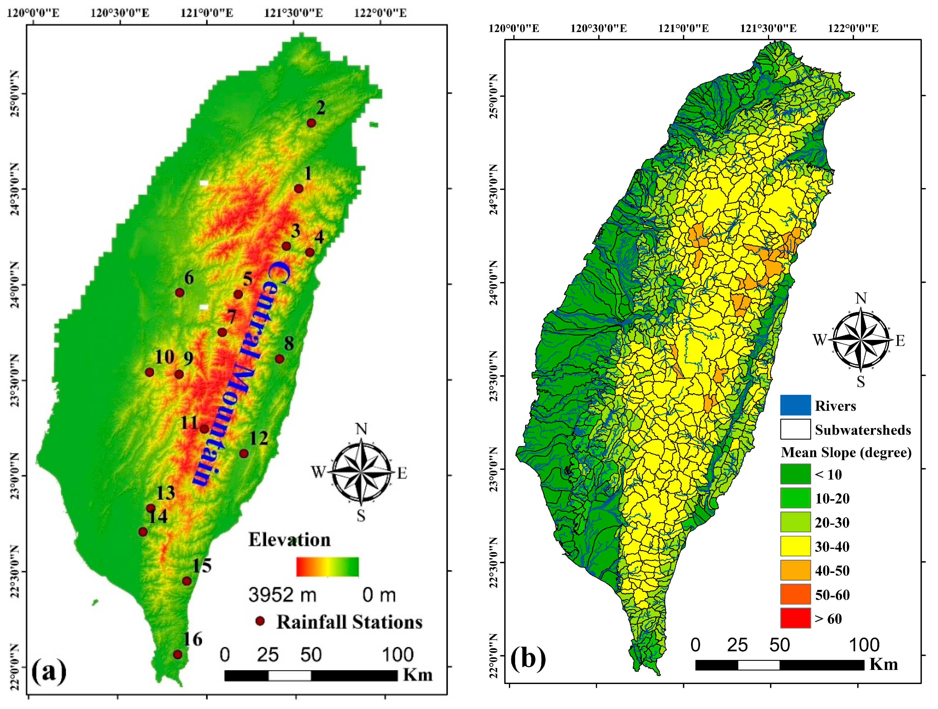
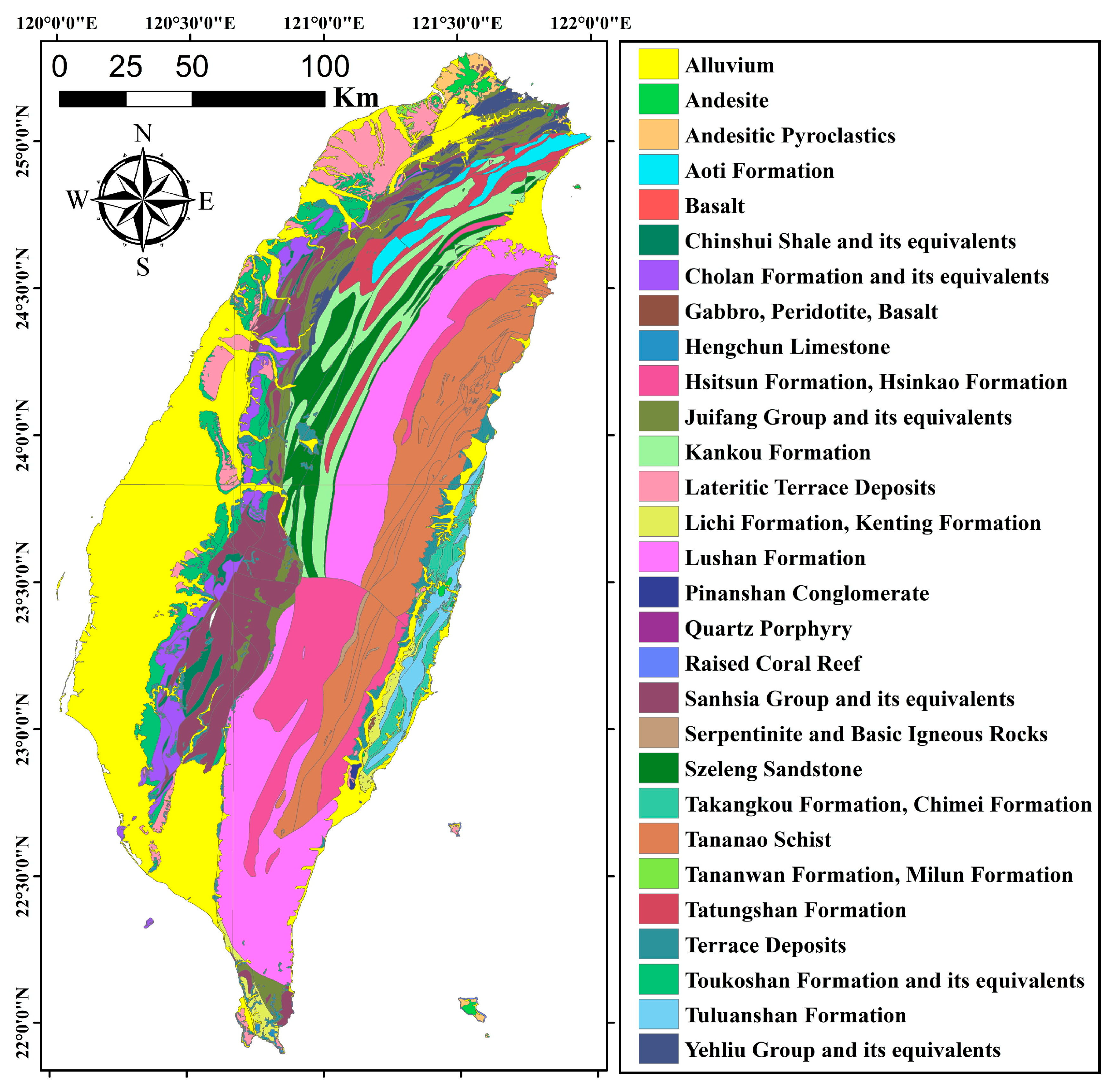
2. Study Area
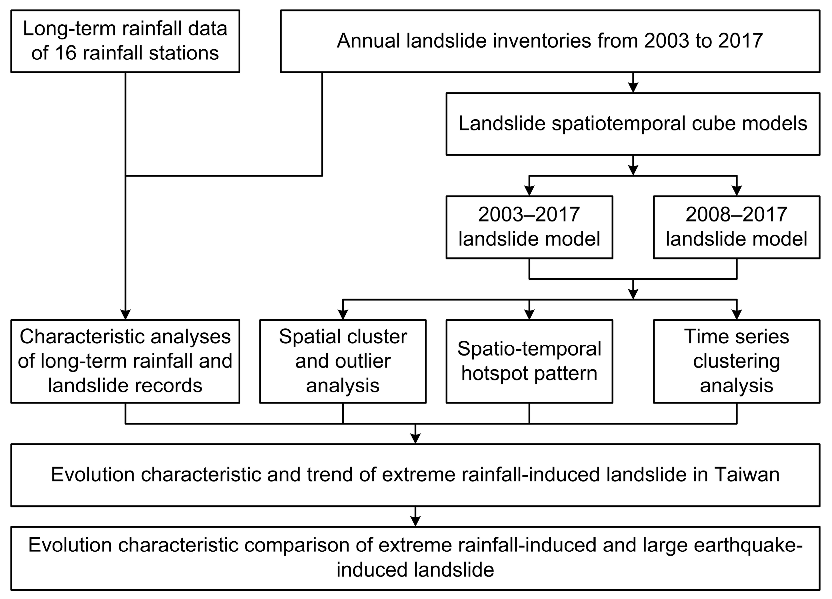
3. Materials and Method
3.1. Materials
3.2. Rainfall Seasonality Index (RSI)
3.3. Landslide Spatiotemporal Cube Models
3.4. Spatial Cluster and Outlier Analysis
3.5. Spatiotemporal Hot Spot Patterns
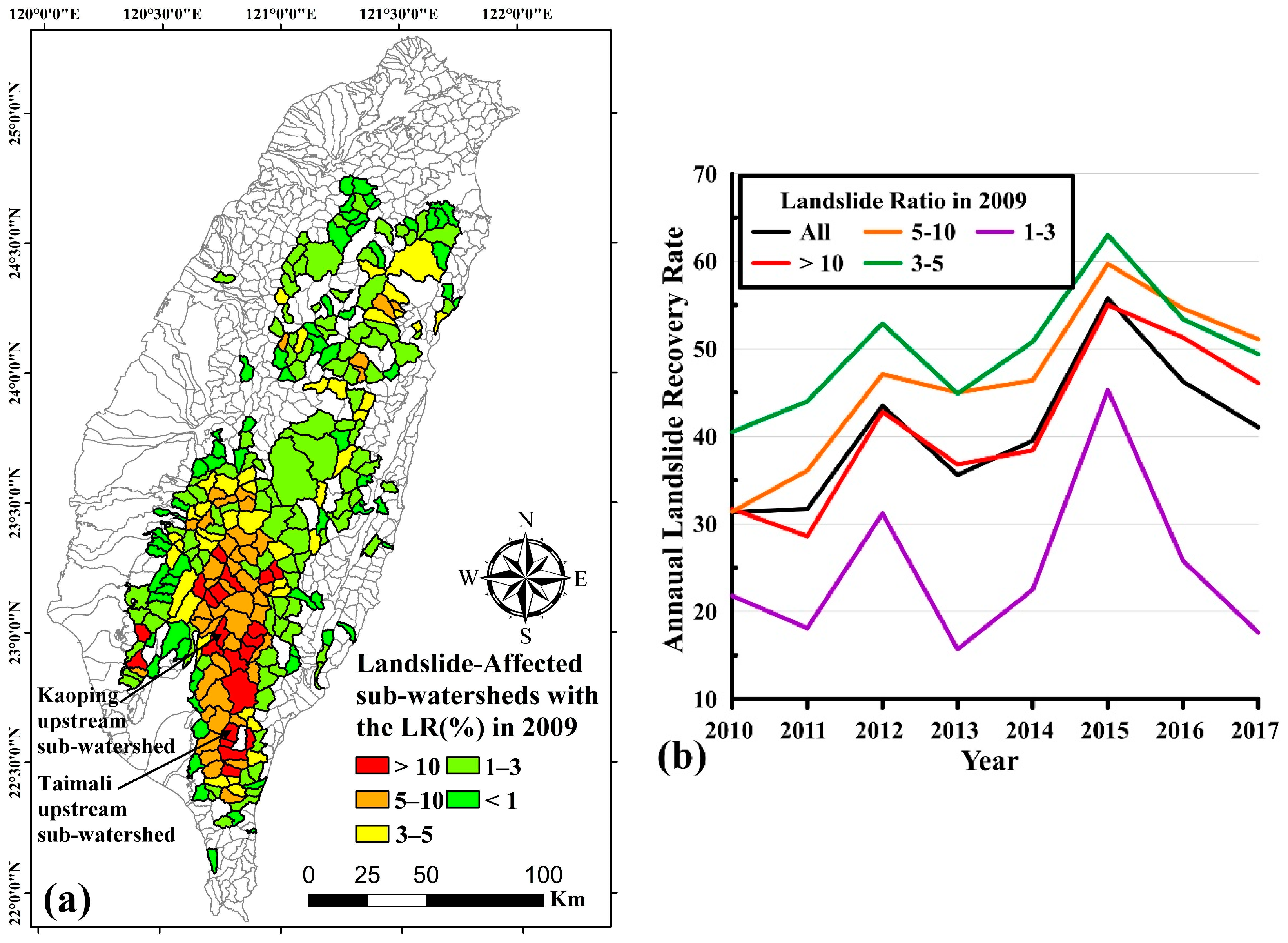
4. Results
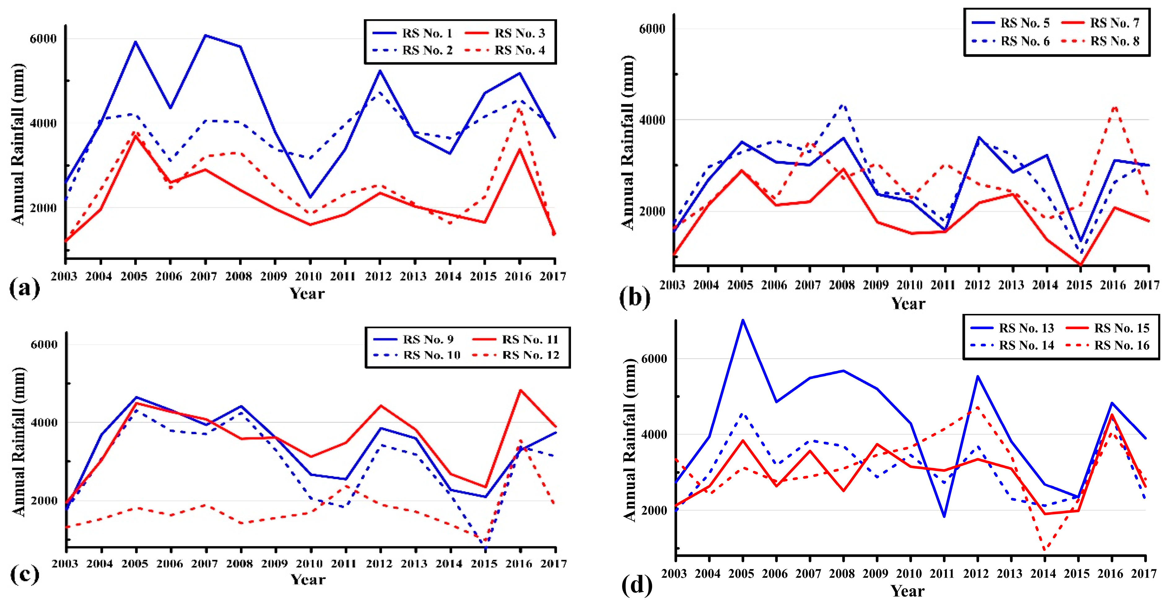
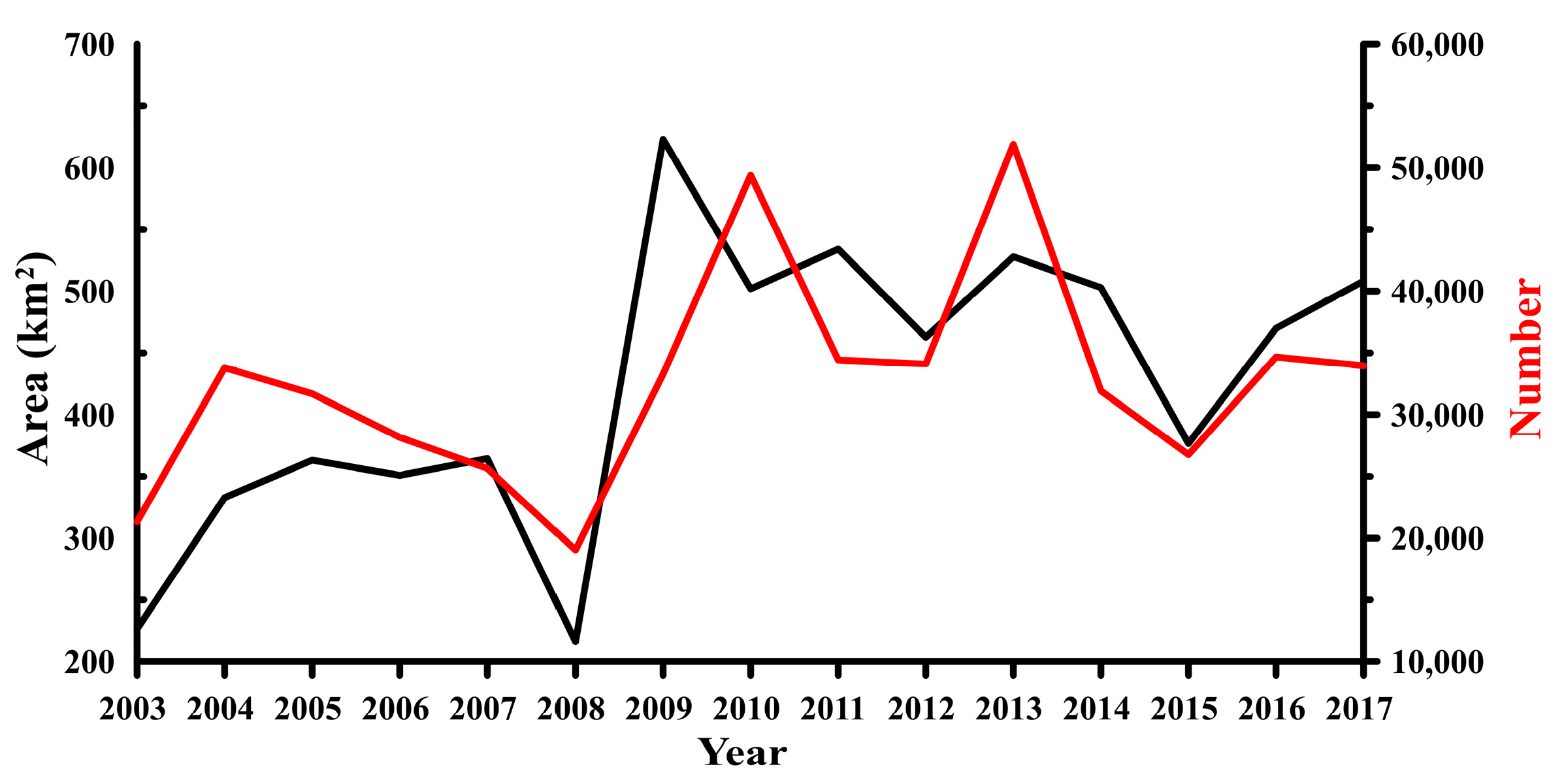
4.1. Long-Term Spatial and Temporal Distribution of Rainfall and Landslide Data in 2003–2017
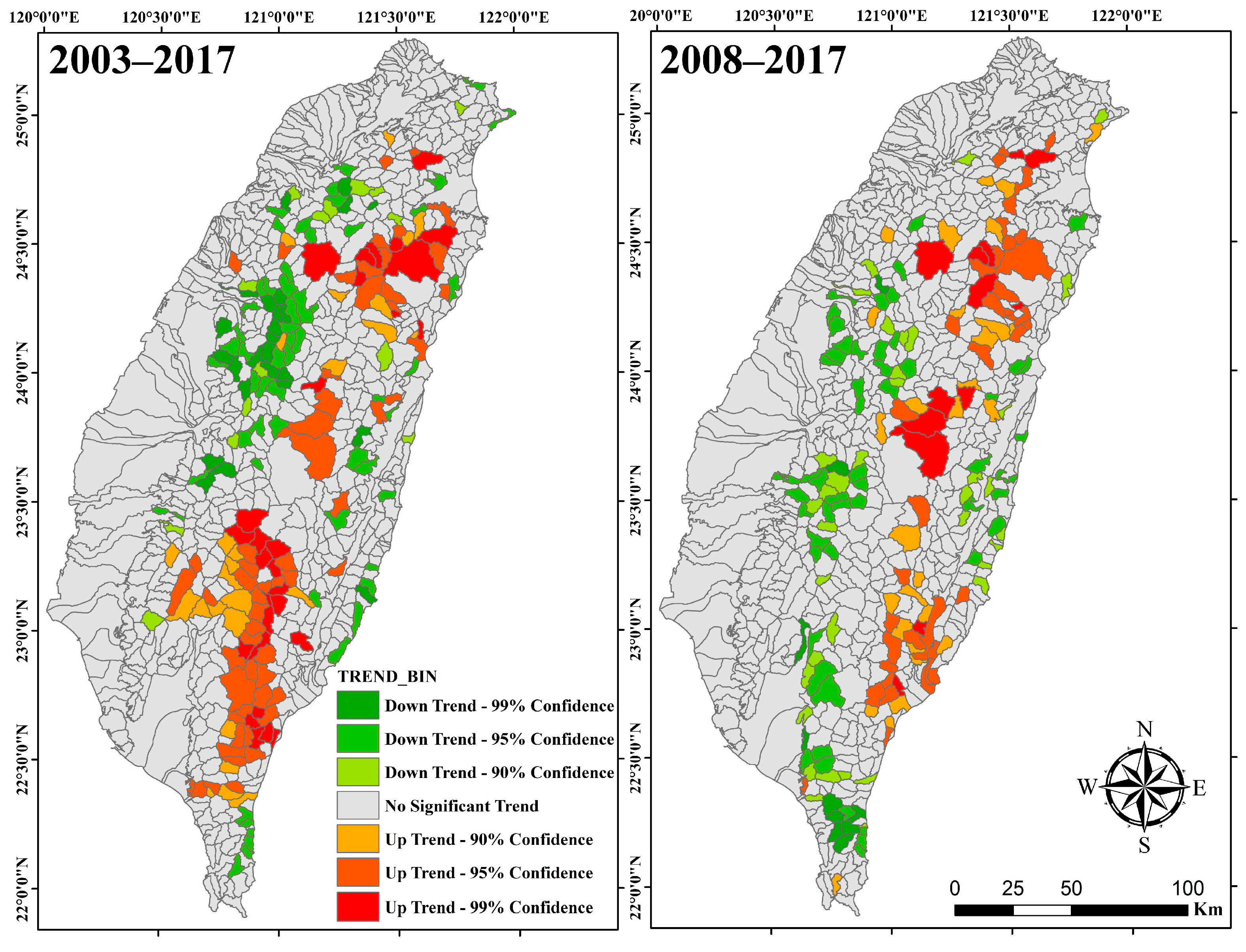
4.2. Landslide Spatialtemporal Cube Model and Trend
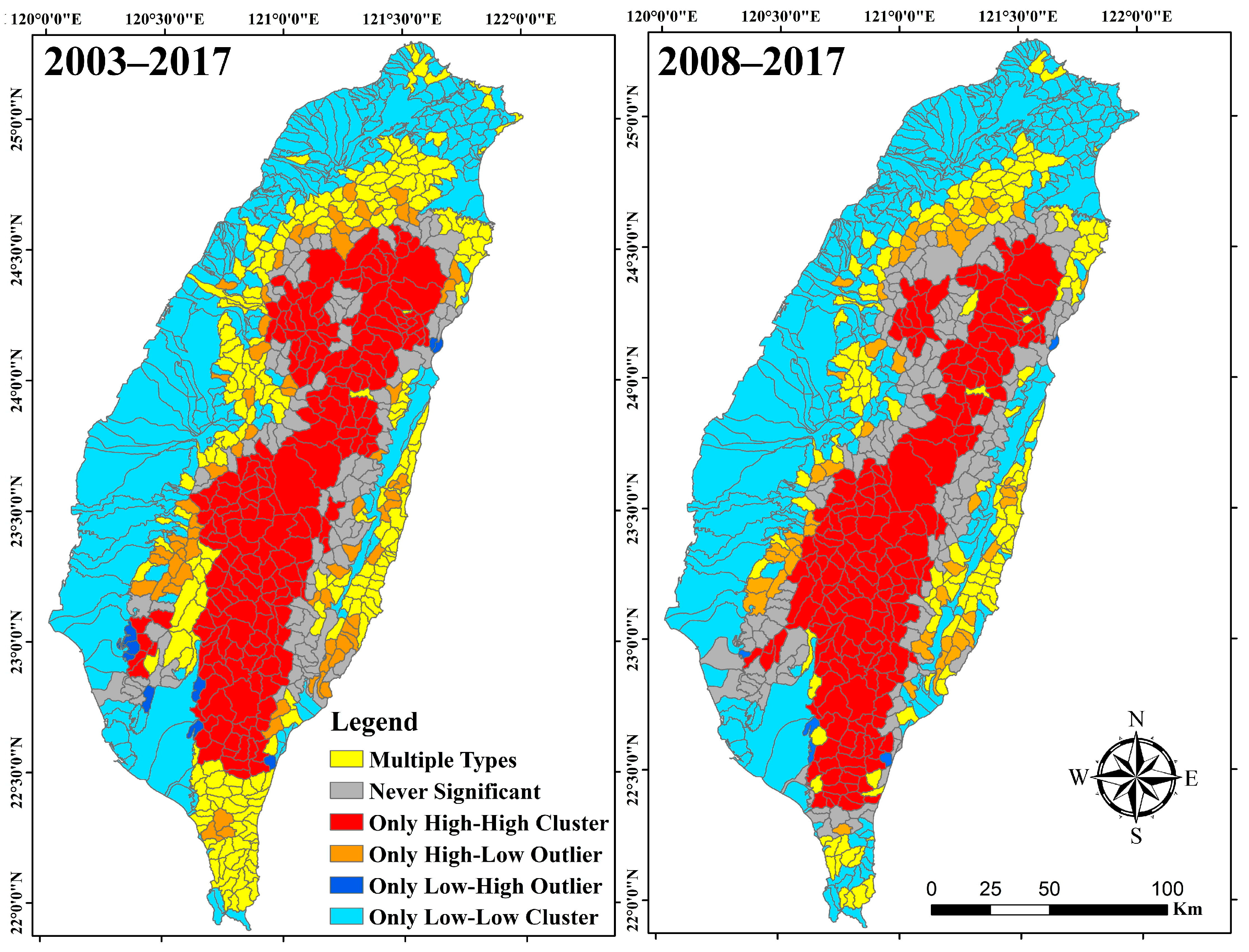
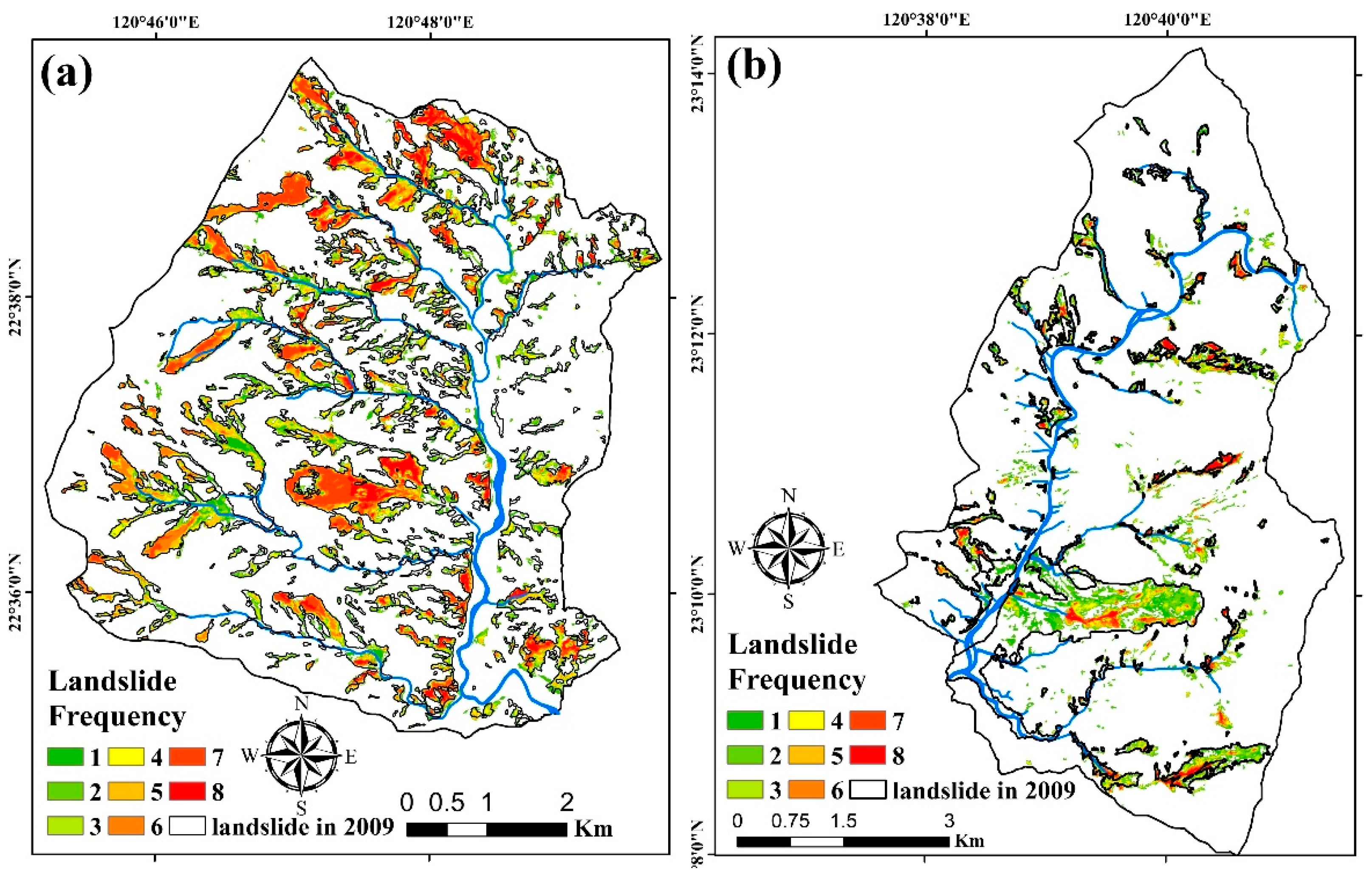
4.3. Results of Spatial Clusters and Outliers
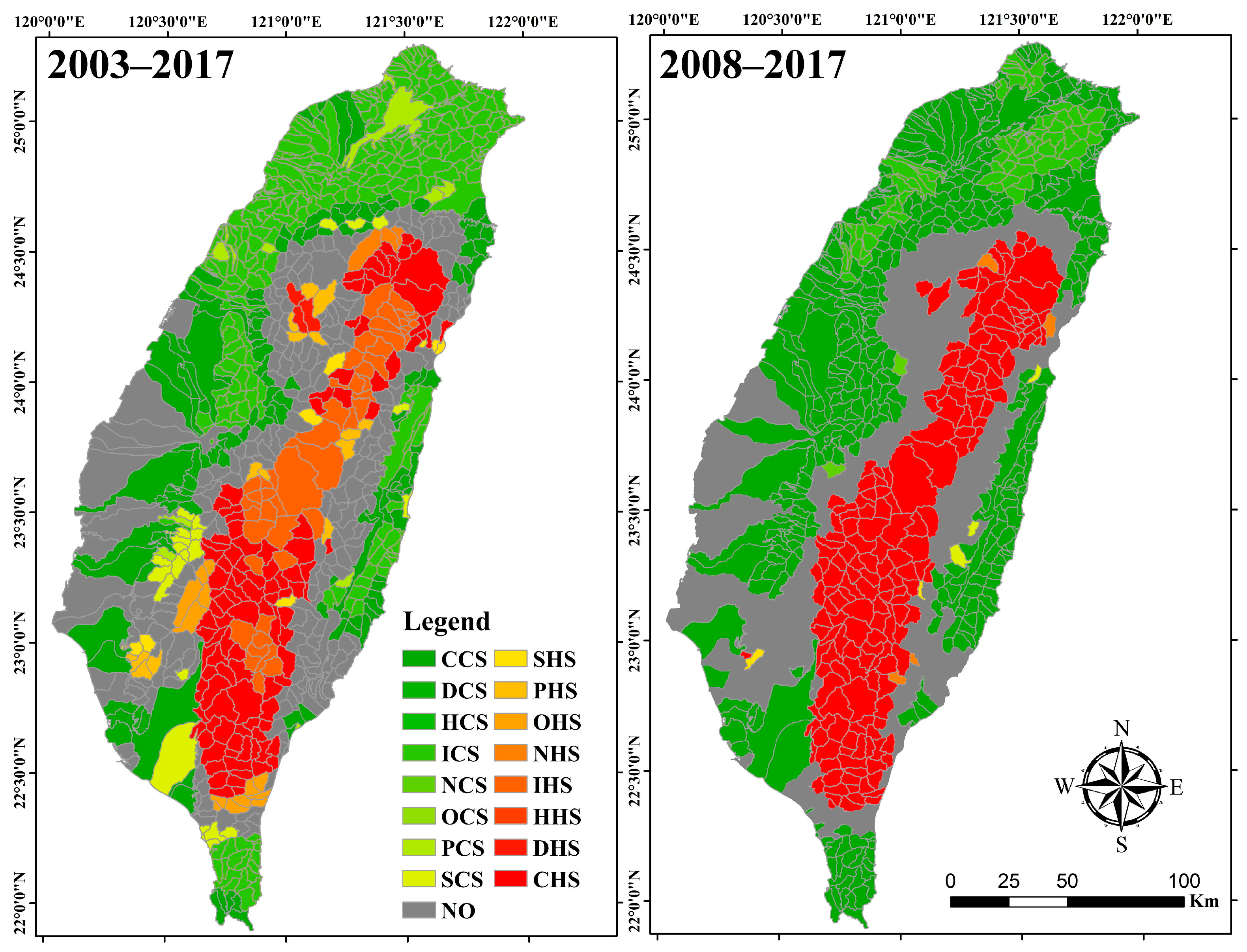
4.4. Landslide Spatiotemporal Hot Spot Analyses
5. Discussion
6. Conclusions
Supplementary Materials
Funding
Data Availability Statement
Conflicts of Interest
References
- Fowler, H.J.; Ali, H. Analysis of extreme rainfall events under the climatic change. In Rainfall Modeling, Measurement and Applications; Morbidelli, R., Ed.; Elsevier: Amsterdam, The Netherlands, 2022; pp. 307–326. [Google Scholar]
- Panagoulia, D.; Bárdossy, A.; Lourmas, G. Diagnostic statistics of daily rainfall variability in an evolving climate. Adv. Geosci. 2006, 7, 349–354. [Google Scholar] [CrossRef]
- Panagoulia, D.; Dimou, G. Sensitivity of flood events to global climate change. J. Hydrol. 1997, 191, 208–222. [Google Scholar] [CrossRef]
- Cheng, J.D.; Huang, Y.C.; Wu, H.L.; Yeh, J.L.; Chang, C.H. Hydrometeorological and landuse attributes of debris flows and debris floods during typhoon Toraji, July 29–30, 2001 in central Taiwan. J. Hydrol. 2005, 306, 161–173. [Google Scholar] [CrossRef]
- Milliman, J.D.; Lee, T.Y.; Huang, J.C.; Kao, S.J. Impact of catastrophic events on small mountainous rivers: Temporal and spatial variations in suspended- and dissolved-solid fluxes along the Choshui River, central western Taiwan, during typhoon Mindulle, July 2–6, 2004. Geochim. Cosmochim. Acta 2017, 205, 272–294. [Google Scholar] [CrossRef]
- Wu, C.H.; Chen, S.C.; Chou, H.T. Geomorphologic characteristics of catastrophic landslides during typhoon Morakot in the Kaoping Watershed, Taiwan. Eng. Geol. 2011, 123, 13–21. [Google Scholar] [CrossRef]
- Wu, C.H.; Chen, S.C.; Feng, Z.Y. Formation, failure, and consequences of the Xiaolin landslide dam, triggered by extreme rainfall from Typhoon Morakot, Taiwan. Landslides 2014, 11, 357–367. [Google Scholar] [CrossRef]
- Wu, C.; Lin, C. Spatiotemporal hotspots and decadal evolution of extreme rainfall-induced landslides: Case studies in southern Taiwan. Water 2021, 13, 2090. [Google Scholar] [CrossRef]
- Wu, C.H. Evaluating the landslide stability and vegetation recovery: Case studies in the Tsengwen reservoir watershed in Taiwan. Water 2021, 13, 3479. [Google Scholar] [CrossRef]
- Shafique, M. Spatial and temporal evolution of co-seismic landslides after the 2005 Kashmir earthquake. Geomorphology 2020, 362, 107228. [Google Scholar] [CrossRef]
- Yang, W.; Qi, W.; Wang, M.; Zhang, J.; Zhang, Y. Spatial and temporal analyses of post-seismic landslide changes near the epicentre of the Wenchuan earthquake. Geomorphology 2017, 276, 8–15. [Google Scholar] [CrossRef]
- Rosser, N.; Kincey, M.; Oven, K.; Densmore, A.; Robinson, T.; Pujara, D.S.; Shrestha, R.; Smutny, J.; Gurung, K.; Lama, S.; et al. Changing significance of landslide Hazard and risk after the 2015 Mw 7.8 Gorkha, Nepal Earthquake. Prog. Disaster Sci. 2021, 10, 100159. [Google Scholar] [CrossRef]
- Chen, C.W.; Chen, H.; Oguchi, T. Distributions of landslides, vegetation, and related sediment yields during typhoon events in northwestern Taiwan. Geomorphology 2016, 273, 1–13. [Google Scholar] [CrossRef]
- Qin, S.; Ding, J.; Ge, X.; Wang, J.; Wang, R.; Zou, J.; Tan, J.; Han, L. Spatio-Temporal Changes in Water Use Efficiency and Its Driving Factors in Central Asia (2001–2021). Remote Sens. 2023, 15, 767. [Google Scholar] [CrossRef]
- Zhao, Z.; Tang, X.; Wang, C.; Cheng, G.; Ma, C.; Wang, H.; Sun, B. Analysis of the Spatial and Temporal Evolution of the GDP in Henan Province Based on Nighttime Light Data. Remote Sens. 2023, 15, 716. [Google Scholar] [CrossRef]
- Wang, S.; Cui, G.; Li, X.; Liu, Y.; Li, X.; Tong, S.; Zhang, M. GRACE Satellite-Based Analysis of Spatiotemporal Evolution and Driving Factors of Groundwater Storage in the Black Soil Region of Northeast China. Remote Sens. 2023, 15, 704. [Google Scholar] [CrossRef]
- Aeberli, A.; Phinn, S.; Johansen, K.; Robson, A.; Lamb, D.W. Characterisation of Banana Plant Growth Using High-Spatiotemporal-Resolution Multispectral UAV Imagery. Remote Sens. 2023, 15, 679. [Google Scholar] [CrossRef]
- Mansour, S.; Ghoneim, E.; El-Kersh, A.; Said, S.; Abdelnaby, S. Spatiotemporal Monitoring of Urban Sprawl in a Coastal City Using GIS-Based Markov Chain and Artificial Neural Network (ANN). Remote Sens. 2023, 15, 601. [Google Scholar] [CrossRef]
- Chen, M.; Tang, C.; Xiong, J.; Shi, Q.Y.; Li, N.; Gong, L.F.; Wang, X.D.; Tie, Y. The long-term evolution of landslide activity near the epicentral area of the 2008 Wenchuan earthquake in China. Geomorphology 2020, 367, 107317. [Google Scholar] [CrossRef]
- Tang, C.; Van Westen, C.J.; Tanyas, H.; Jetten, V.G. Analysing post-earthquake landslide activity using multi-temporal landslide inventories near the epicentral area of the 2008 Wenchuan earthquake. Nat. Hazards Earth Syst. Sci. 2016, 16, 2641–2655. [Google Scholar] [CrossRef]
- Liu, C.C.; Liu, J.G.; Lin, C.W.; Wu, A.M.; Liu, S.-H.; Shieh, C.-L. Image processing of formosat-2 data for monitoring south Asia tsunami. Int. J. Remote Sens. 2007, 28, 3093–3111. [Google Scholar] [CrossRef]
- Liu, C.C.; Ko, M.H.; Wen, H.L.; Fu, K.L.; Chang, S.-T. Instability Index Derived from a Landslide Inventory for Watershed Stability Assessment and Mapping. ISPRS Int. J. Geo-Inf. 2019, 8, 145. [Google Scholar] [CrossRef]
- Wu, C. Certainty Factor Analyses and Spatiotemporal Characteristics of Landslide Evolution: Case Studies in the Chishan River Watershed in Taiwan. ISPRS Int. J. Geo-Inf. 2022, 11, 382. [Google Scholar] [CrossRef]
- Ma, S.; Qiu, H.; Zhu, Y.; Yang, D.; Tang, B.; Wang, D.; Wang, L.; Cao, M. Topographic Changes, Surface Deformation and Movement Process before, during and after a Rotational Landslide. Remote Sens. 2023, 15, 662. [Google Scholar] [CrossRef]
- Kuang, J.; Ng, A.H.-M.; Ge, L.; Metternicht, G.I.; Clark, S.R. Joint Use of Optical and Radar Remote Sensing Data for Characterizing the 2020 Aniangzhai Landslide Post-Failure Displacement. Remote Sens. 2023, 15, 369. [Google Scholar] [CrossRef]
- Li, C.; Wang, M.; Liu, K. A decadal evolution of landslides and debris flows after the Wenchuan earthquake. Geomorphology 2018, 323, 1–12. [Google Scholar] [CrossRef]
- Kincey, M.E.; Rosser, N.J.; Robinson, T.R.; Densmore, A.L.; Shrestha, R.; Pujara, D.S.; Oven, K.J.; Williams, J.G.; Swirad, Z.M. Evolution of Coseismic and Post-seismic Landsliding After the 2015 Mw 7.8 Gorkha Earthquake, Nepal. J. Geophys. Res. Earth Surf. 2021, 126, e2020JF005803. [Google Scholar] [CrossRef]
- Roback, K.; Clark, M.K.; West, A.J.; Zekkos, D.; Li, G.; Gallen, S.F.; Chamlagain, D.; Godt, J.W. The size, distribution, and mobility of landslides caused by the 2015 Mw7.8 Gorkha earthquake, Nepal. Geomorphology 2018, 301, 121–138. [Google Scholar] [CrossRef]
- Zhang, X.; Chen, L.; Zhou, C. Deformation Monitoring and Trend Analysis of Reservoir Bank Landslides by Combining Time-Series InSAR and Hurst Index. Remote Sens. 2023, 15, 619. [Google Scholar] [CrossRef]
- Medhat, N.I.; Yamamoto, M.-Y.; Ichihashi, Y. Inclinometer and Improved SBAS Methods with a Random Forest for Monitoring Landslides and Anchor Degradation in Otoyo Town, Japan. Remote Sens. 2023, 15, 441. [Google Scholar] [CrossRef]
- Conforti, M.; Mercuri, M.; Borrelli, L. Morphological Changes Detection of a Large Earthflow Using Archived Images, LiDAR-Derived DTM, and UAV-Based Remote Sensing. Remote Sens. 2021, 13, 120. [Google Scholar] [CrossRef]
- Lin, S.C.; Ke, M.C.; Lo, C.M. Evolution of landslide hotspots in Taiwan. Landslides 2017, 14, 1491–1501. [Google Scholar] [CrossRef]
- Science. A Massive Experiment in Taiwan Aims to Reveal Landslides’ Surprising Effect on the Climate. Available online: https://www.science.org/content/article/massive-experiment-taiwan-aims-reveal-landslides-surprising-effect-climate (accessed on 25 January 2023).
- Government Open Data. Available online: https://data.gov.tw/dataset/140111 (accessed on 24 September 2022).
- Hydrological Data in Taiwan. Available online: https://www.wra.gov.tw/cp.aspx?n=3168 (accessed on 24 September 2022).
- Walsh, R.P.D.; Lawler, D.M. Rainfall seasonality: Description, spatial patterns and change through time. Weather 1981, 36, 201–208. [Google Scholar] [CrossRef]
- Tanyas, H.; Kirschbaum, D.; Görüm, T.; van Westen, C.J.; Tang, C.; Lombardo, L. A closer look at factors governing landslide recovery time in post-seismic periods. Geomorphology 2021, 391, 107912. [Google Scholar] [CrossRef]
- Anselin, L. Local indicators of spatial association-LISA. Geogr. Anal. 1995, 27, 93–115. [Google Scholar] [CrossRef]
- Getis, A.; Ord, J.K. The analysis of spatial association by use of distance statistics. Geogr. Anal. 1992, 24, 189–206. [Google Scholar] [CrossRef]
- ESRI Website. Available online: https://pro.arcgis.com/en/pro-app/2.8/tool-reference/space-time-pattern-mining/emerginghotspots.htm (accessed on 24 September 2022).
- Liu, J.; Mason, P.J.; Bryant, E.C. Regional assessment of geohazard recovery eight years after the Mw7.9 Wenchuan earthquake: A remote-sensing investigation of the Beichuan region. Int. J. Remote Sens. 2018, 39, 1671–1695. [Google Scholar] [CrossRef]
- Tsai, S.R. Spatial Variation of Soil Properties in Kaoping River Basin Prior and Post Typhoon Morakot. Master’s Thesis, National Pingtung University of Science and Technology, Taiwan, 2011; p. 52. [Google Scholar]
- Lousada, S.; Cabezas, J.; Castanho, R.A.; Gómez, J.M.N. Hydraulic Planning in Insular Urban Territories: The Case of Madeira Is-land—Ribeira Brava. Water 2021, 13, 2951. [Google Scholar] [CrossRef]
- Lousada, S.; Gonçalves, L.; Atmaca, A. Hydraulic Planning in Insular Urban Territories: The Case of Madeira Island—São Vicente. Water 2022, 14, 112. [Google Scholar] [CrossRef]
- Lousada, S.; Castanho, R.A. GIS-Based Assessment of Morphological and Hydrological Parameters of Ribeira Dos Socorridos and Ribeira Do Vigario Basins, Madeira Island, Portugal. Curr. World Environ. 2021, 16, 408–426. [Google Scholar] [CrossRef]
- Lousada, S.A.N.; Moura, A.D.S.; Gonçalves, L.B. Numerical modelling of the flow rate in artificial water channels: Application to Ribeira Brava’s stream. Rev. Bras. Planej. Desenvolv. 2020, 9, 39–59. [Google Scholar] [CrossRef]
- Lousada, S.; Cabezas, J.; Castanho, R.A.; Gómez, J.M.N. Land-Use Changes in Insular Urban Territories: A Retrospective Analysis from 1990 to 2018. The Case of Madeira Island—Ribeira Brava. Sustainability 2022, 14, 16839. [Google Scholar] [CrossRef]
- Liu, C.-C.; Chen, P.-L. Automatic extraction of ground control regions and orthorectification of formosat-2 imagery. Opt. Express 2009, 17, 7970–7984. [Google Scholar] [CrossRef] [PubMed]
- Liu, C.-C.; Shieh, C.-L.; Wu, C.-A.; Shieh, M.-L. Change detection of gravel mining on riverbeds from the multi-temporal and high-spatial-resolution formosat-2 imagery. River Res. Appl. 2009, 25, 1136–1152. [Google Scholar] [CrossRef]


| RSI | Rainfall Regime |
|---|---|
| ≤0.19 | Very equable |
| 0.20–0.39 | Equable but with a definite wetter season |
| 0.40–0.59 | Rather seasonal with a short drier season |
| 0.60–0.79 | Seasonal |
| 0.80–0.99 | Markedly seasonal with a long drier season |
| 1.00–1.19 | Most rain in 3 months or less |
| ≥1.20 | Extreme, almost rain in 1–2 months |
| No. of RS 1 | Region | RSI | No. of RS 1 | Region | RSI |
|---|---|---|---|---|---|
| 1 | Northern Taiwan | 0.62 | 9 | Western Taiwan | 0.73 |
| 2 | 0.36 | 10 | 0.84 | ||
| 3 | Eastern Taiwan | 0.47 | 11 | Southeastern Taiwan | 0.76 |
| 4 | 0.65 | 12 | 0.70 | ||
| 5 | Western Taiwan | 0.56 | 13 | Southwestern Taiwan | 0.78 |
| 6 | 0.78 | 14 | 0.94 | ||
| 7 | Eastern Taiwan | 0.64 | 15 | Southern Taiwan | 0.74 |
| 8 | 0.45 | 16 | 0.64 |
| Type | Numbers of Sub-Watersheds | |
|---|---|---|
| 2003–2017 | 2008–2017 | |
| Mul. * | 214 | 137 |
| NS * | 101 | 142 |
| HH * | 206 | 197 |
| HL * | 68 | 53 |
| LH * | 9 | 5 |
| LL * | 241 | 305 |
| Pattern | Occupied Percentage | Pattern | Occupied Percentage | ||
|---|---|---|---|---|---|
| 2003–2017 | 2008–2017 | 2003–2017 | 2008–2017 | ||
| Cold spot | 50.1 | 52.8 | Hot spot | 24.2 | 22.6 |
| CCS | 15.5 | 44.0 | CHS | 13.2 | 21.9 |
| DCS | 0.0 | 0.0 | DHS | 0.4 | 0.0 |
| HCS | 0.0 | 0.0 | HHS | 0.0 | 0.0 |
| ICS | 30.5 | 8.2 | I HS | 6.0 | 0.0 |
| NCS | 0.0 | 0.2 | NHS | 0.4 | 0.5 |
| OCS | 0.0 | 0.0 | OHS | 1.5 | 0.0 |
| PCS | 1.2 | 0.0 | PHS | 1.8 | 0.0 |
| SCS | 2.9 | 0.4 | SHS | 1.0 | 0.2 |
| No pattern | 25.7 | 24.6 | |||
Disclaimer/Publisher’s Note: The statements, opinions and data contained in all publications are solely those of the individual author(s) and contributor(s) and not of MDPI and/or the editor(s). MDPI and/or the editor(s) disclaim responsibility for any injury to people or property resulting from any ideas, methods, instructions or products referred to in the content. |
© 2023 by the author. Licensee MDPI, Basel, Switzerland. This article is an open access article distributed under the terms and conditions of the Creative Commons Attribution (CC BY) license (https://creativecommons.org/licenses/by/4.0/).
Share and Cite
Wu, C. Using the Spatiotemporal Hot Spot Analysis and Multi-Annual Landslide Inventories to Analyze the Evolution and Characteristic of Rainfall-Induced Landslide at the Subwatershed Scale in Taiwan. Water 2023, 15, 1355. https://doi.org/10.3390/w15071355
Wu C. Using the Spatiotemporal Hot Spot Analysis and Multi-Annual Landslide Inventories to Analyze the Evolution and Characteristic of Rainfall-Induced Landslide at the Subwatershed Scale in Taiwan. Water. 2023; 15(7):1355. https://doi.org/10.3390/w15071355
Chicago/Turabian StyleWu, Chunhung. 2023. "Using the Spatiotemporal Hot Spot Analysis and Multi-Annual Landslide Inventories to Analyze the Evolution and Characteristic of Rainfall-Induced Landslide at the Subwatershed Scale in Taiwan" Water 15, no. 7: 1355. https://doi.org/10.3390/w15071355
APA StyleWu, C. (2023). Using the Spatiotemporal Hot Spot Analysis and Multi-Annual Landslide Inventories to Analyze the Evolution and Characteristic of Rainfall-Induced Landslide at the Subwatershed Scale in Taiwan. Water, 15(7), 1355. https://doi.org/10.3390/w15071355