1. Introduction
Ice and snow exist as the solid states of water at a low temperature and are highly related to atmosphere and hydrosphere. They are parts of human living environments in cold regions as well. In the context of global warming, ice and snow exhibit significant changes due to their sensitivity to temperature. The influences of these variations on human activity may seem to stand independently but are in fact integrated within the cryosphere if the scope is enlarged to a geographical scale. The IPCC WGI AR4 (2007) states that the main components of the cryosphere are snow, river and lake ice, sea ice, glaciers and ice caps, ice shelves, ice sheets, and frozen ground [
1].
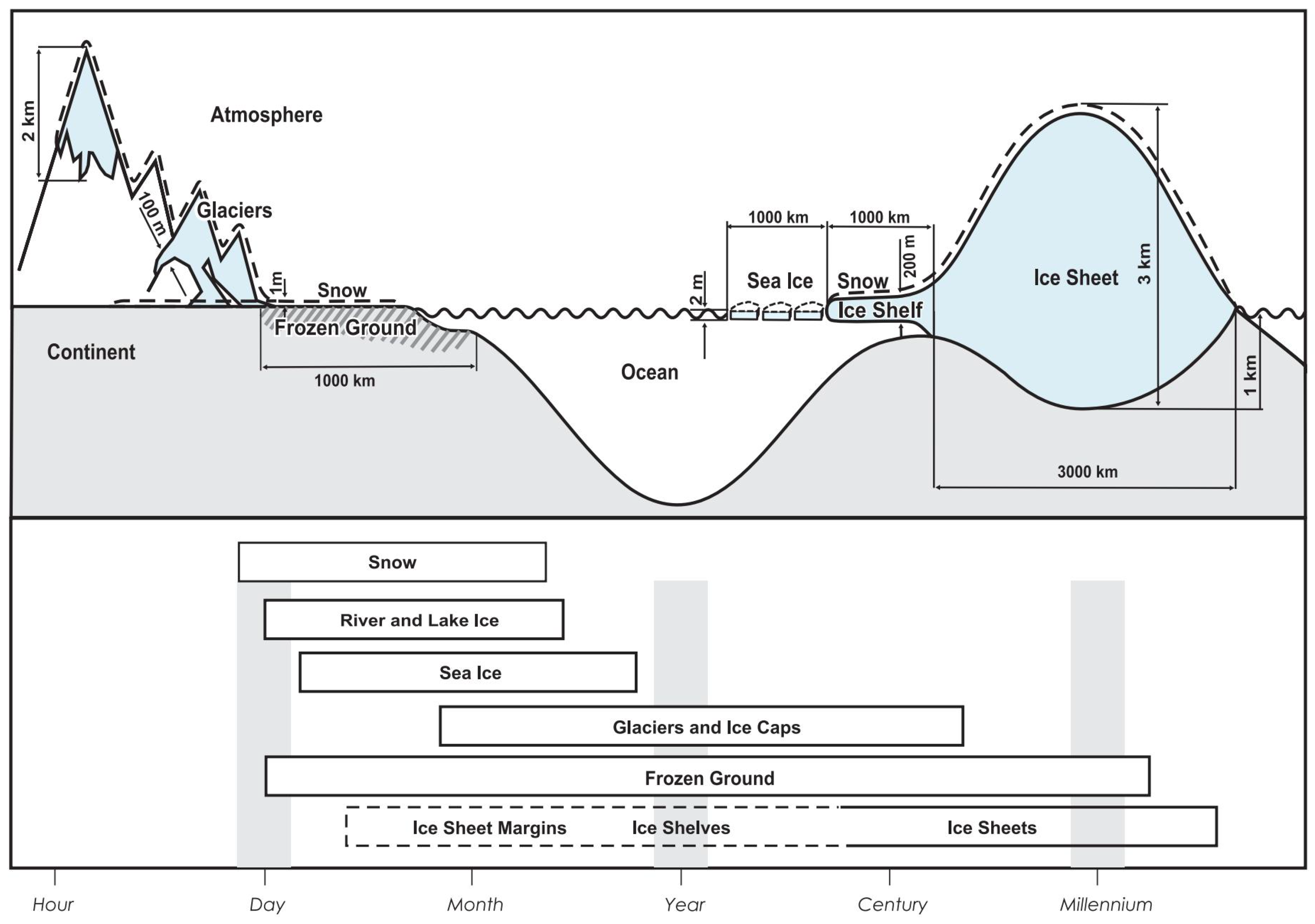
Figure 1 illustrates their connections at the spatial and temporal scales, showing both the independency and integration of these components. Being located at a medium latitude, China has no ice caps, but there are mountain glaciers in regions of high altitudes. The melting of glaciers provides water sources to rivers and lakes. Global warming has promoted the melting of glaciers and increased the water level of lakes in Northwest of China [
2,
3]. The water in these rivers and lakes then enter the sea via runoffs either above- or under- ground. Ice occurs in the Bohai Sea and the northern part of the Yellow Sea every winter, but most of the ice on Earth exists at polar regions of high latitudes.
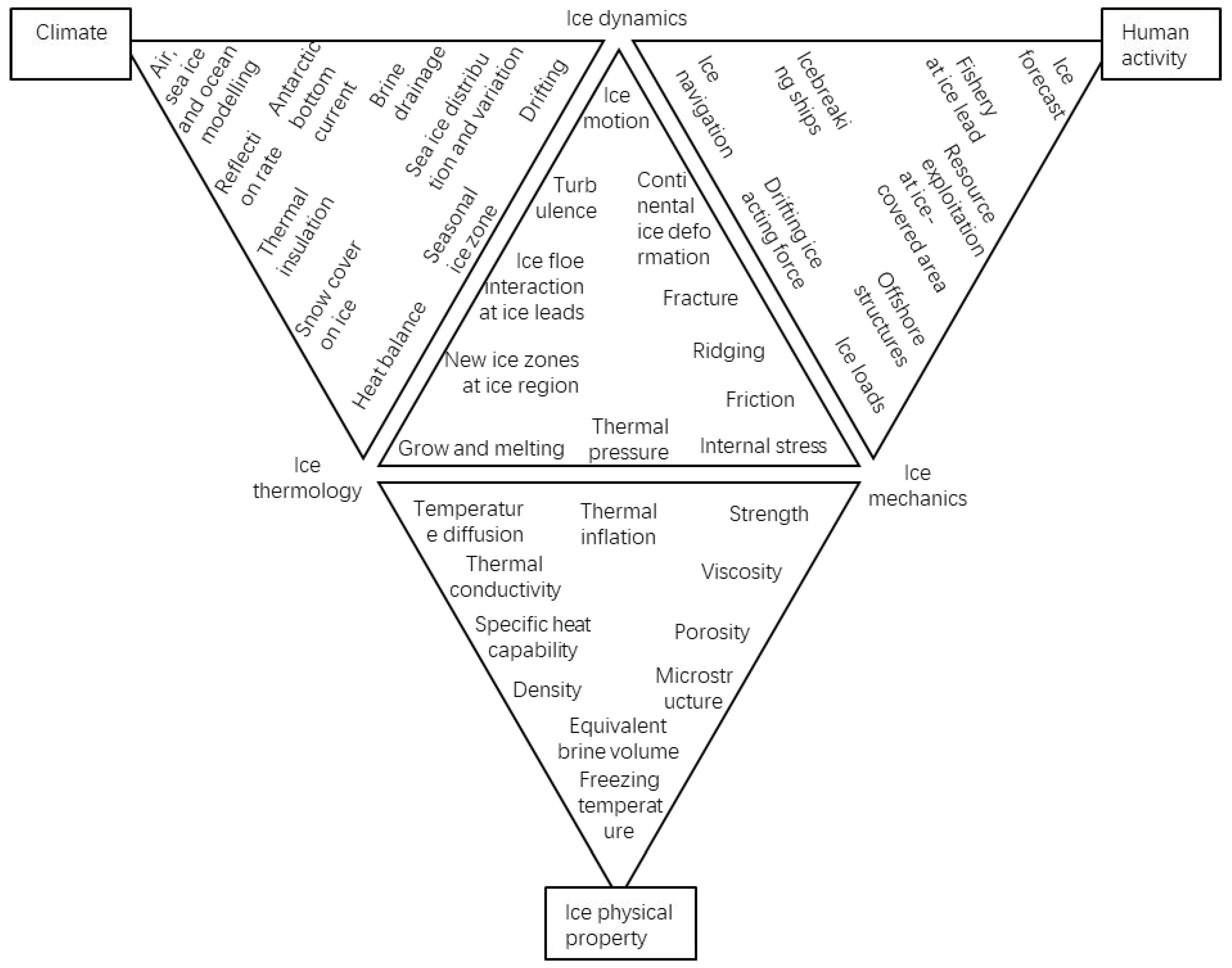
Research on ice engineering is driven by human activities and is essentially focused on the properties of ice, either at a small or a large scale. With sea ice as an example, Ding (1999) overviewed engineering properties of sea ice [
4] and introduced the tetrahedron proposed by a Japanese scientist summarizing the relationships between ice physical properties, climate, and human activities. This tetrahedron can be opened from the top to form a big triangle composed of four small triangles [
4], as shown in
Figure 2. Ice thermology, ice mechanics, and ice dynamics are the three basic apexes. Although this sketch does not cover all the aspects, it concisely conveys the interconnections between many ice-related research fields and reflects the fact that the physical property of sea ice is the fundament of other research topics. In recent years, increased navigation through the northern sea route in the Arctic regions has incurred a large number of research studies focusing on the interaction between ice and its structures [
5,
6].
Due to global warming, lake ice, river ice, and sea ice are all reducing. These cause delayed formation of ice, formation of thinner ice, and shorter duration of seasonal ice covers. Therefore, the geographical ice margin moves further away from the equator, multiyear ice becomes thinner and decreases in extent, and, as a result, the fraction of first-year ice becomes higher [
7]. There are also other phenomena, including an increase in ice temperature, a decrease in ice salinity, a reduction in ice density, and a widened varying range of ice density [
8]. It has become a new topic around the world as to whether these would induce an increase in under-ice radiation flux and water temperature [
9,
10], thereby affecting under-ice environments during freezing seasons. In China, many lakes are utilized for aquaculture, which is tightly related to these issues. It is important to investigate the changes in underwater ecosystems and form a holistic understanding of the changes at different latitudes and altitudes around the world. On the basis of this, it is of significance to connect the prediction of climate change to under-ice ecosystems in lakes. The Special Issue, entitled “Sea, River, Lake Ice Properties and Their Applications in Practices”, is proposed under such context, which invites researchers from different fields to contribute their investigation on scientific and technological problems at different temporal and spatial scales.
In this Special Issue, we focus on “higher temperature” ice properties and their applications. This Special Issue can guide future ice science and engineering in polar regions under climate change. Therefore, it covers the physical, thermal, mechanical, and electrical properties of any kind of crystal ice. The scope of this Special Issue also includes research on remote sensing, engineering, ecosystem, and entertainment through the use of multi-approaches of testing, theoretical analysis, numerical modeling, and physical modeling.
2. Summary of This Special Issue
This Special Issue received 24 manuscripts, of which 15 papers are published. The contents of these published papers are water resources from mountain glaciers, lake ice phenology, ice properties and their application in practices, sea ice engineering, and newly developed ecosystem environments under lake ice.
Two papers are published on water resources from mountain glaciers and mountain glaciers’ variation in the past 50 years in Xinjiang Area. Liu et al. [
11] proposed that the dynamic change in the glacier material balance in Tianshan Mountain is of significant scientific value for assessing the impact of climate on water resources. These water resources are the ecological barrier of the oasis in the northwest arid region in Xinjiang. The authors used a spatially distributed degree-day model using multi-source remote sensing data, such as MOD11C3 and TRMM3B43, to simulate the mass balance in the Tianshan Mountains’ south and north slope basins, and they compared and attributed the spatiotemporal heterogeneity of the mass balance by using a geographical detector. They obtained the changes in glacier size, distribution, material balance, as well as their formation causes, in typical basins on the northern and southern slopes of the Tianshan Mountains. The results show the characteristics of water resource changes and water resource regulation in the north and south slope basins of the Tianshan Mountains. The other contribution is from Zhang et al. (2022) [
12]. This paper combines GIS spatial analytical techniques to explore the characteristics of glacier changes in Xinjiang and its response to topography and climate change in the past 50 years. The results show that the glaciers in Xinjiang during these 50 years are mainly receding and splitting. In particular, small glaciers are more sensitive to climate change. Phenomena such as glacier extinction and splitting result in an increasing number of glaciers but a decreasing total area of glaciers in the southern mountains. Topographic relief is the most important factor controlling the spatial differentiation of glacier changes among the topographic factors. The lack of a corresponding increase in precipitation is one of the reasons for the apparent shrinkage of glacial resources in the study area. The changes in glacier resources and their meltwater runoff contributions in Xinjiang are of great significance to hydrological processes and water resource utilization.
On lake ice phenology, there are two papers published in this Special Issue. One paper covers the Eurasian Lakes, and the other paper focuses on the case of Wuliangsu Lake, about 200 km
2 in area located near the Yellow River in Inner Mongolia, China. The Eurasian freezing lakes has a vast scope, covering nearly one quarter of Earth, which ice phenology varies widely. The degree-day method is generally used to investigate variations in ice phenology, but it only pays attention to temperature without considering another critical factor—radiation. Thus, a mathematically complete and physically meaningful analytical model is introduced in the study by Leppäranta and Wen (2022) [
13], which provides a first-order tool for evaluating climate sensitivity of ice seasons. Their results show that local temperature, radiation, and their gradients are the key factors influencing ice phenology, especially in the Tibetan Plateau with strong radiation. Freezing depends on lake depth, and breakup depends on accumulated ice thickness The freezing date and breakup date both change by around five days per one-degree shift in air temperature away from the climatological ice margin. This work helps re-recognize freezing lakes’ ice phenology in the two dimensions of altitudes and spatial distribution and provides a supplement to our understanding of land–air interaction. Huoet al. (2022) [
14] studied the ice phenology of Wuliangsu Lake using optical satellite data. Considering the possible effect of clouds above the lake [
15], the authors developed a new algorithm based on remote sensing modeling to tackle this challenge. Finally, they effectively removed the influence of aquatic plants and clouds on lake ice identification and obtained satisfactory results with daily monitoring.
Ice properties and their applications in different practices, except for ice engineering, constitute a large part of the research in this Special Issue. There are four papers that rely on full-scale measurement data concerning Chinese river ice and the Antarctic ice sheet. In river management, to solve the problems of existing time-consuming and inaccurate ice velocity monitoring methods, Wang et al. (2022) [
16] proposed a new ice velocity extraction method based on a UAV-based remote sensing technology. High-resolution orthoimages were obtained with a UAV during the ice flood period, and the feature points in the drift ice images were then extracted using a scale-invariant feature transform (SIFT) algorithm. With the use of the random sample consensus (RANSAC) algorithm, the authors tracked the motion trajectories of these feature points, and an ice displacement rate field was finally established. Meanwhile, research on river ice thickness also calls for improvements of existing measuring techniques. Ground-penetrating radar (GPR) has proven to be a very effective method for examining ice thickness. Han et al. (2022) [
17] carried out a series of GPR surveys using dual-channel host 200 MHz shielded antennas at the Toudaoguai Hydrological Station on the Yellow River, China, and collected samples to analyze ice impurities and physical properties. A combination of GPR data, as well as ice impurities, porosity, density, and temperature, provides insights into the variability of radar transmission speed and the equivalent dielectric permittivity in river ice. The results show that the radar transmission speed falls between 0.141 m/ns and 0.164 m/ns, and the equivalent dielectric permittivity of river ice increases in concert with ice temperature. Lu et al. (2022) [
18] analyzed the ice fabrics and microstructures of 23 one-meter-long ice cores drilled from blue ice areas at the shear margin of Dalk Glacier, Antarctica. Their results show the type and evolution of ice fabrics under shear stress of ice flow and bedrock. The characteristics of grain and bubble properties are revealed, and the mechanism of the formation of ice layers in these study sites are discussed. The stable water isotopes of these ice cores are also analyzed to study the correlations with ice fabrics and microstructures.
Under laboratory conditions and with the use of non-natural ice, two papers present newly researched results. To understand disc ice floes’ surface melting, bottom melting, and lateral melting during the melting season, tests under controlled conditions were performed in a cold laboratory [
19]. The results show that the bottom melting rate is larger than the lateral melting rate, followed by the surface melting rate, and the smaller the size of an ice floe, the higher the lateral melting rate. According to the experimental data, a new indicator was created using the ratio of the diameter to the thickness of an ice sample. Therefore, the relationships between the surface/bottom melting rates and temperature gradient were formulated; the relationship among the lateral melting rate, the temperature difference, and the ratio of the diameter to the thickness was also quantified. These two equations can be applied to the melting parametrization scheme of ice for a range of diameters up to 100 m, which covers simulations of the energy and mass balance values of the Arctic sea ice and coastal fresh-water ice during the summer melting season [
19]. Zhang et al. (2022) [
20] studied the uniaxial compressive strength of distilled-water ice grown at different temperatures in a cryogenic laboratory, which differs from previous research that has mainly focused on the effect of test temperature. The results show that the uniaxial compressive strength of ice is a power function of the strain rate and has a linear relationship with the -1/2 power of grain size. Additionally, it is found that the peak compressive strength has a logarithmic relationship with the growth temperature. In addition, it is deduced that the growth temperature affects the strength of ice by controlling the grain size.
Liu et al. (2002) [
21] is the only paper that uses computer-assisted tools to apply ice properties to practice. Liu et al. (2022)’s paper combines various ice blasting theories and engineering practice results; specifically, the authors applied the blasting theory of Euler’s theorem and the JWL (Jones–Wilkins–Lee) state equation, and they used the ANSYS/LSDYNA software to simulate ice blasting effects under different ice conditions. Through an analysis of ice simulation data and a verification of the measured data, this paper summarizes and deduces the blasting vector mode which is suitable for the main stream of Heilongjiang Province, China.
Three papers examining the navigation problems of polar ships are included in this Special Issue. In the paper by Zhou et al. (2022a) [
22], the authors calculated ice resistance using the circumferential crack method and the Monte Carlo methods in a probabilistic way for the first time, considering the effect of both ice thickness and bending strength based on the measured data from the Chinese Xuelong Icebreaker. The simulation results show that the Burr distribution is the most suitable model to describe the distribution of the calculated ice resistance and the ice-force amplitude concentrated at a lower level. The numerical tool can provide a significant reference for ice-going ships sailing in level ice in most scenarios with regard to ice resistance and operational safety with high accuracy and computational efficiency. Meanwhile, Zhou et al. (2022b) [
23] proposed an overlapping grid method based on CFD to analyze propeller performance during a typical ice blockage condition. The ice blockage model is simulated by using a water-insoluble rectangular solid block, and ice blockage is measured by the distance between the solid block and the propeller. Compared to the model test data, it shows the numerical difference is less than 5%, which is quite accurate. The present method is reasonable and vital to propeller design and optimization. Other than ice forces on the ship body and propellers, icing is possible to occur in polar navigation vessels. In the paper by Chen et al. [
24], a study on the generation and distribution of sea spray is carried out to address the problem of ice accumulation forecasting for polar navigation vessels, and new research ideas and directions are proposed. In order to solve the problem that sea spray cannot be quantified using the traditional finite element grid calculation method, this research mainly adopts the calculation method of smoothed-particle hydrodynamics and uses the Lagrangian particle tracking idea to accurately capture the motion state of each particle and to calculate the relevant physical quantity in real time, which innovatively achieves an accurate measurement of sea spray, breaking through the traditional sea spray droplet on sailing ship coverage and the proportion of the difficult problem that cannot be quantified. The research results can serve as a guidance for other fields, such as marine structure design, polar ship icing forecast, and others.
The mooring system of a floating offshore structure in the Arctic region is another kind of engineering application in the Arctic. For instance, Zhang et al. (2022) [
25] investigated an optimal mooring system for the Kulluk platform operating in the Beaufort Sea under ice-free and ice-covered conditions during a whole year. In order to complete the layout design of the mooring system to satisfy the year-round operation, both the effects of wave loads and ice loads should be considered. This research establishes a coupled numerical production system composed of a platform and a mooring system. The nonlinear finite element method, the discrete element method, and empirical formula are used to analyze the ice loads. The simulated results are found to compare reasonably with the field measurements. A quantitative time-domain analysis is carried out to study the mooring line configurations. This research work will provide a reference for the optimal design of mooring systems of the platforms operating in the Arctic Sea.
In addition to traditional ice property application in ice engineering, water ecosystem environment under lake ice has become a new topic in Cryosphere Science [
26]. Although it is difficult to solve the collaborative carrying capacity of water resources, water environment, and water ecology in Wuliangsuhai Lake due to the long ice period, strong evapotranspiration, and intensified interference of human activities, Ren et al. [
27] innovatively construct an evaluation index system and method to evaluate the collaborative carrying capacity of Wuliangsuhai Lake water resources–water environment–water ecology, including the calculation module of ice period, and realizes the dynamic simulation and regulation of the collaborative carrying capacity under multiple scenarios. Their results have certain extensibility and portability. The primary productivity beneath the ice is an important variable for understanding of how temperate lake ecosystems are changing due to global warming.


