
Using Geographic Information Systems and Multi-Criteria Decision Analysis to Determine Appropriate Locations for Rainwater Harvesting in Erbil Province, Iraq

 ,
,  , ,
, ,
Abstract
:1. Introduction
2. Materials and Methods
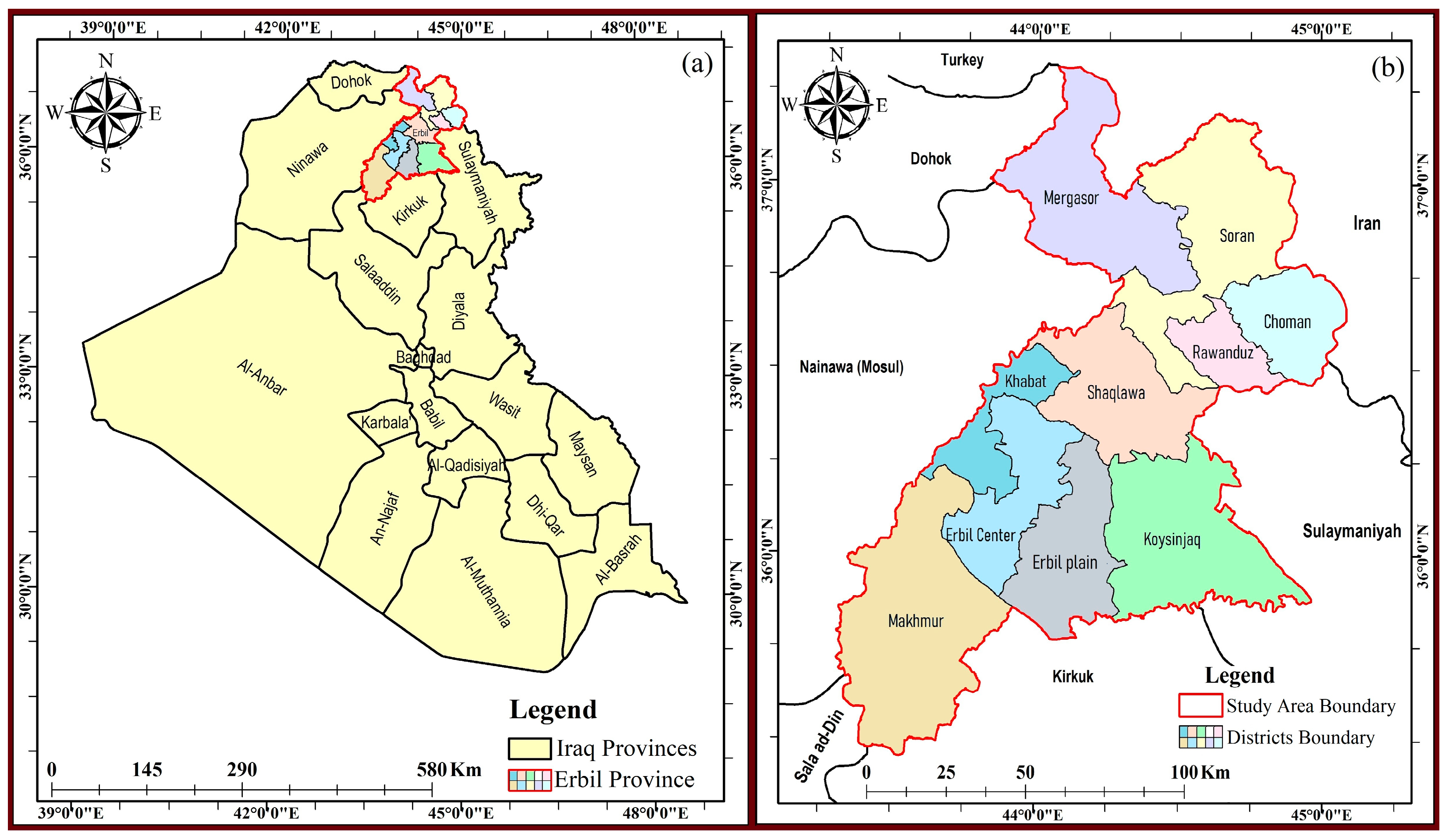
2.1. Study Area
2.2. Dataset
- Remote sensing data, including a Landsat 8 Operational Land Imager (OLI) satellite image dated 14 April 2023, and a Digital Elevation Model (DEM) sourced from the Shuttle Radar Topography Mission (SRTM) with a 30 m resolution, were accessed on 15 June 2023, from https://earthexplorer.usgs.gov [28].
- Rainfall data for 10 years (2014–2023) were obtained from 23 meteorological stations belonging to the Ministry of Agriculture and Water Resources (KRG).
- Soil data were retrieved from the digital soil map of the world (DSMW) developed by the Food and Agriculture Organization (FAO) and the United Nations Educational, Scientific, and Cultural Organization (UNESCO) (FAO-UNESCO 2008) [29], accessed on 10 July 2023.
2.3. Criteria Selection and Preparation
2.3.1. Rainfall
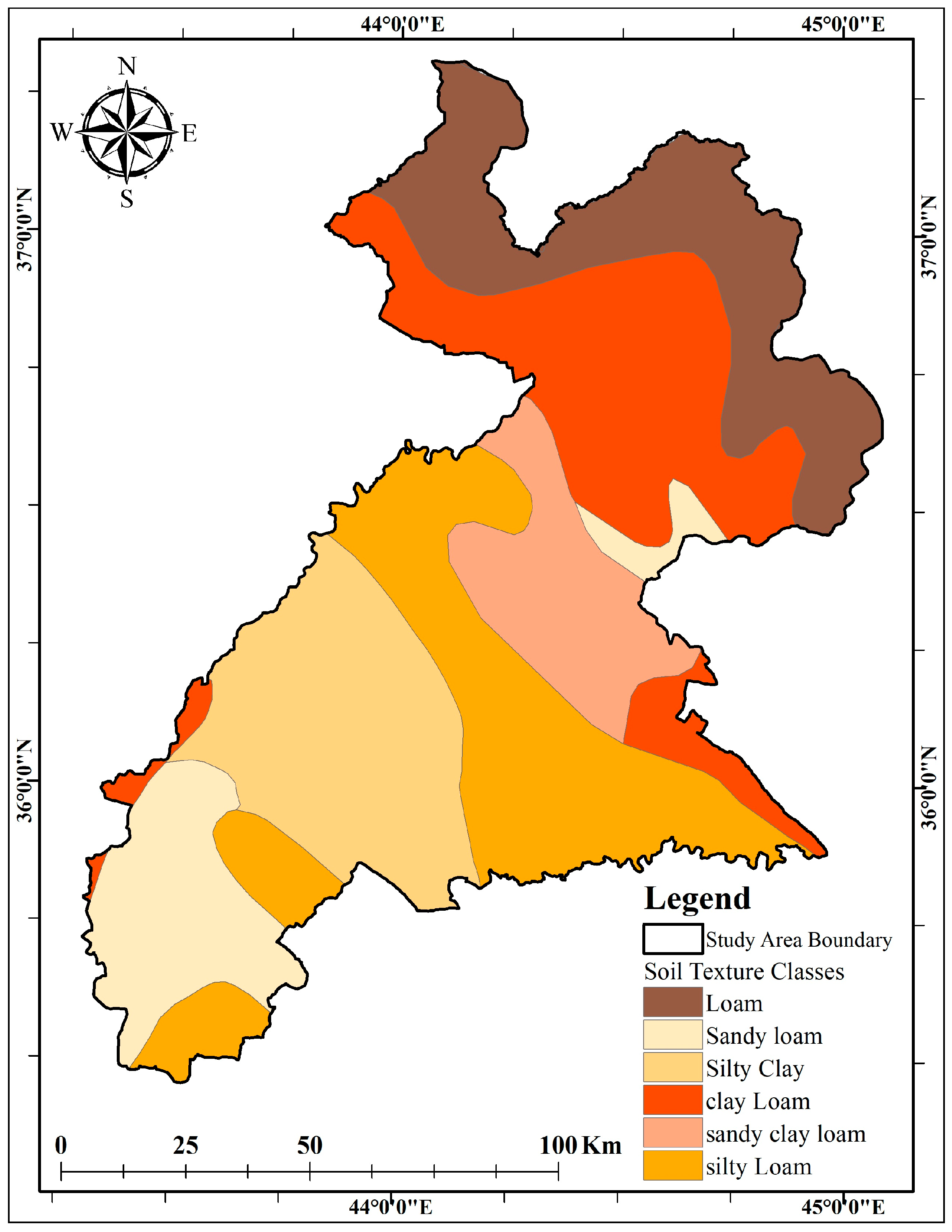
2.3.2. Soil Texture
2.3.3. Land Use and Land Cover (LU/LC)
2.3.4. Runoff Depth
2.3.5. Drainage Density (DD)
2.3.6. Slope
2.3.7. Topographic Wetness Index (TWI)
2.4. Criteria Prioritization
2.5. Multi-Criteria Decision Analysis (MCDA)
2.6. Generating the RWH Suitability Zone Map
2.7. Suitable Sites Selection for Different RWH Structures
2.8. Validation
3. Results and Discussion
3.1. Thematic Layers
3.1.1. Rainfall
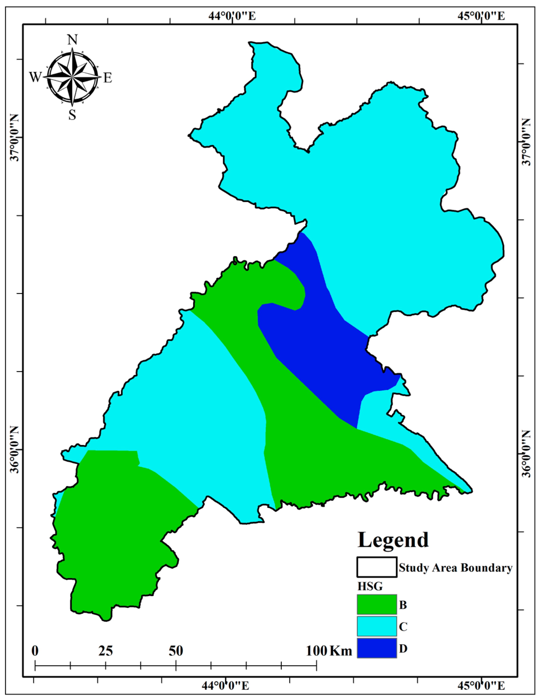
3.1.2. Soil Properties
3.1.3. LU/LC
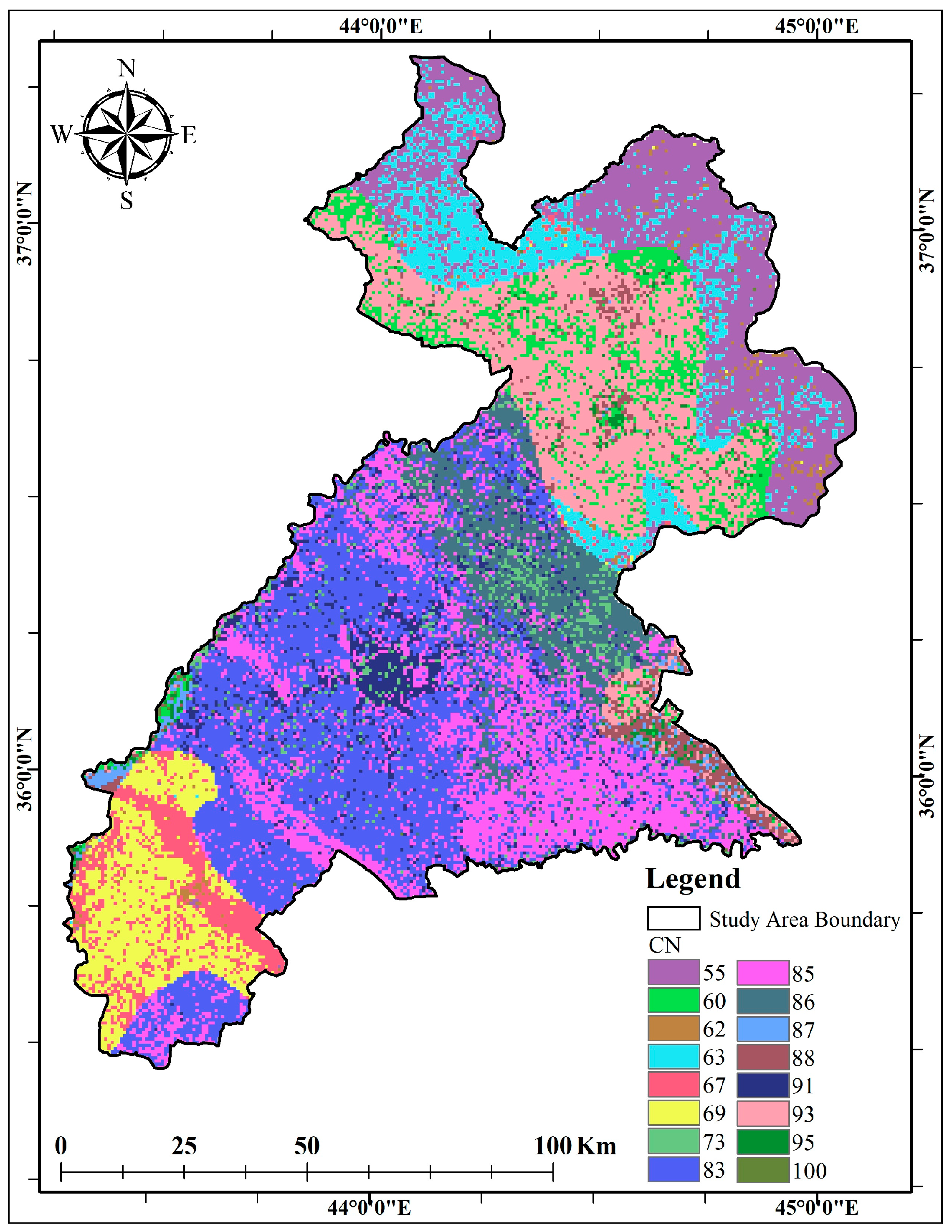
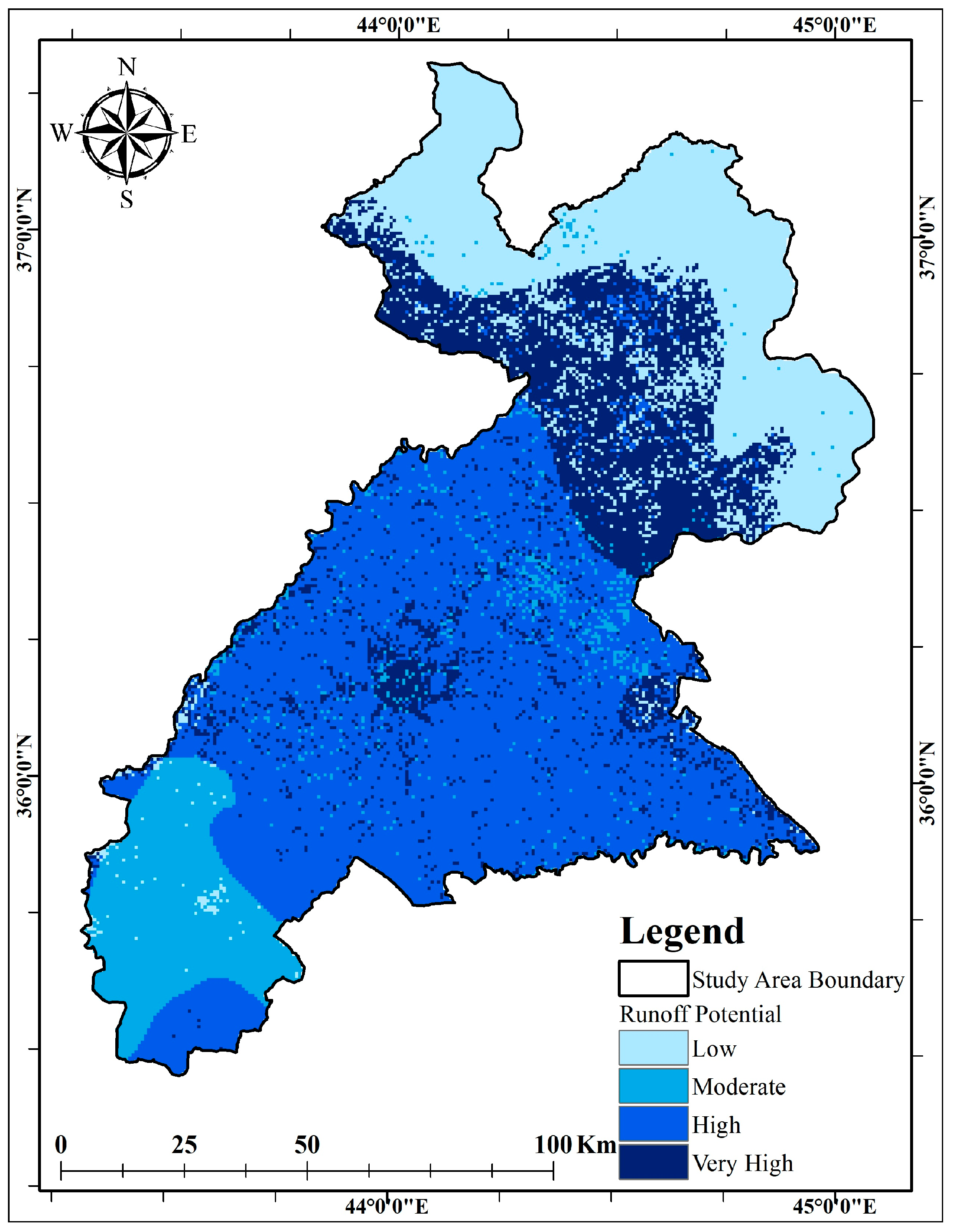
3.1.4. Runoff Estimation
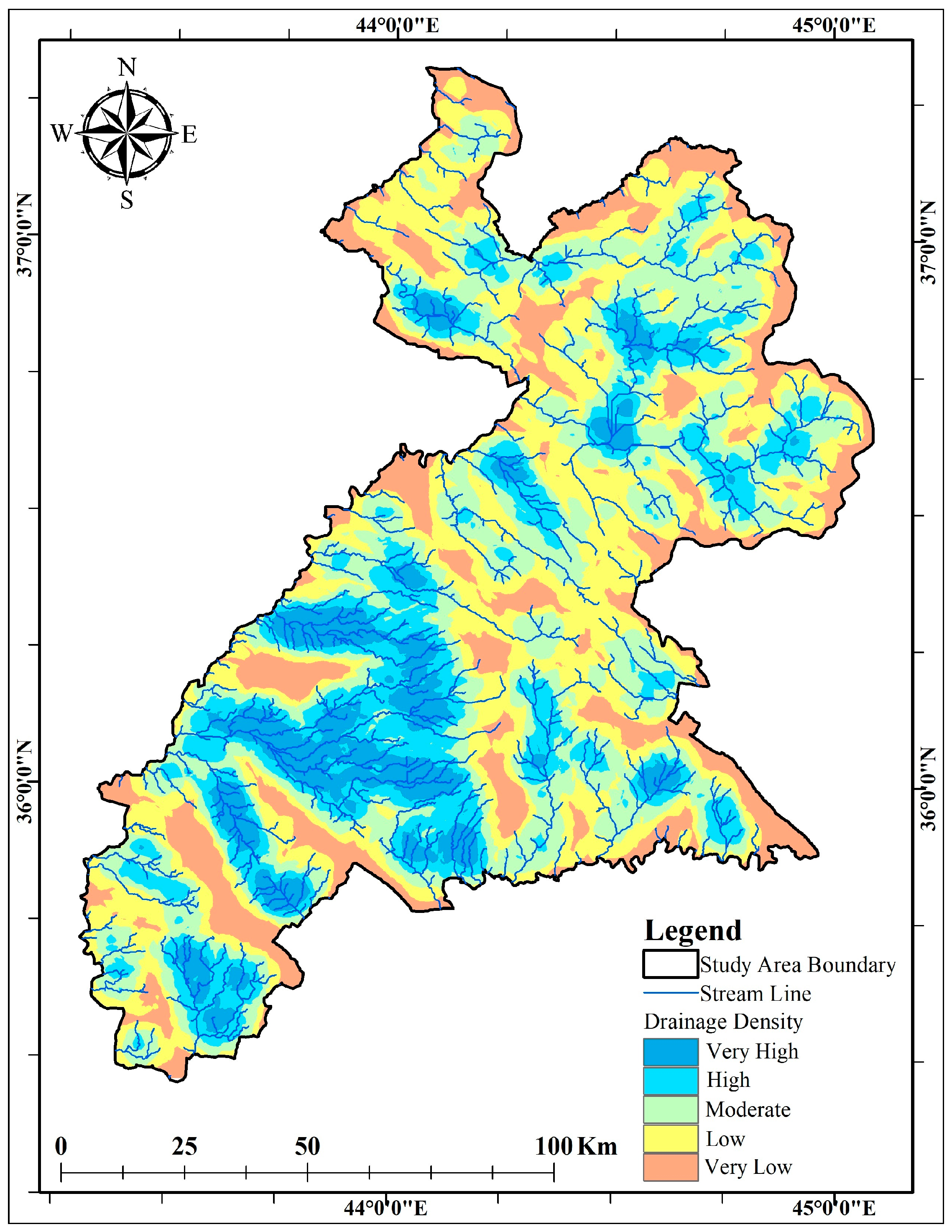
3.1.5. Drainage Density
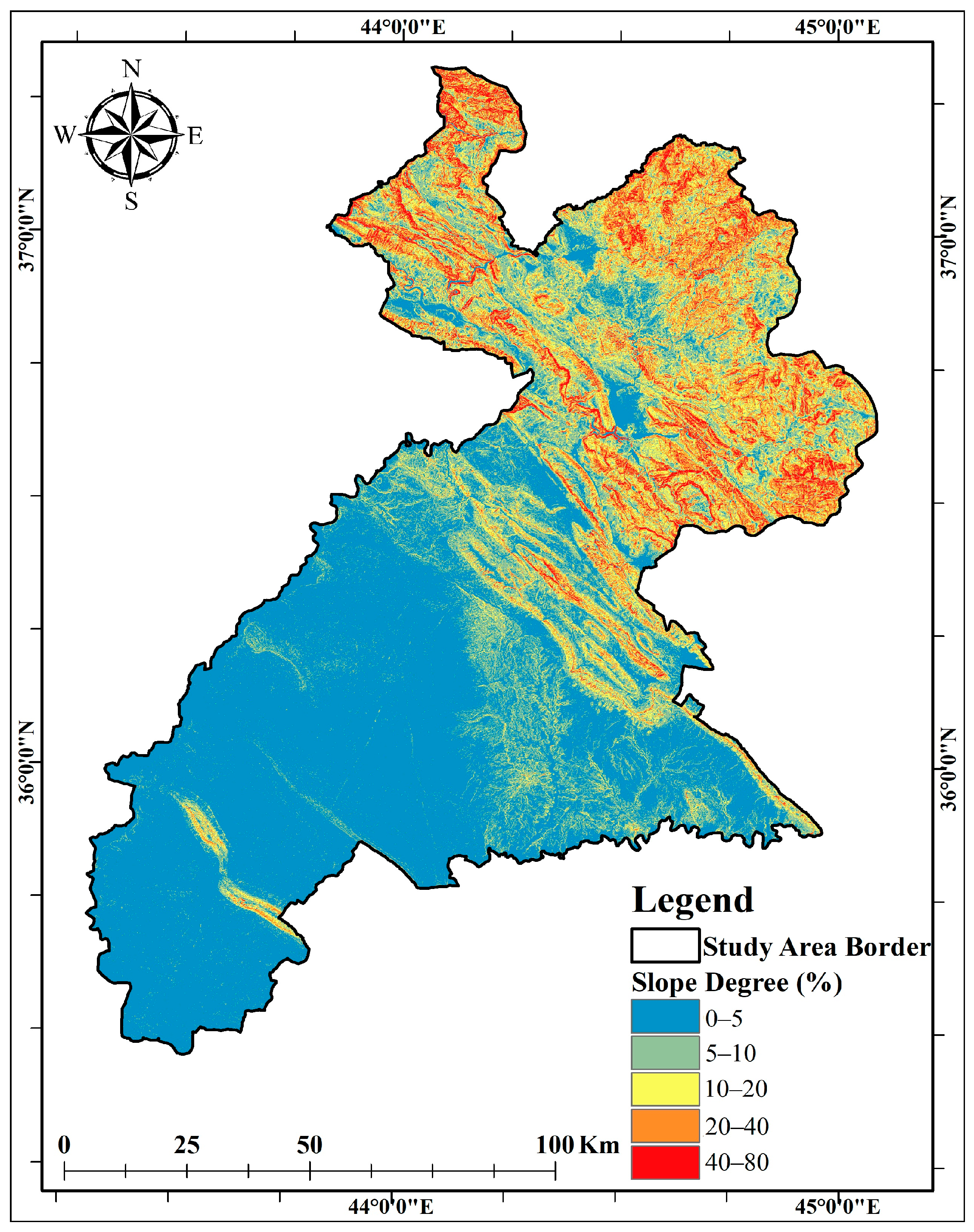
3.1.6. Slope
3.1.7. TWI
3.2. Criteria Prioritization and the MCDA Process
3.3. RWH Suitable Zone
3.4. Appropriate Sites for RWH Structures
3.5. Validation
4. Conclusions
Author Contributions
Funding
Data Availability Statement
Conflicts of Interest
References
- Abdalla, Z.F.; El-Sawy, S.; El-Bassiony, A.E.; Zhaojun, S.; Okasha, A.; Bayoumi, Y.; El-Ramady, H.; Prokisch, J. Is the Smart Irrigation the Right Strategy under the Global Water Crisis? A Call for Photographical and Drawn Articles. Environ. Biodivers. Soil Secur. 2022, 6, 207–221. [Google Scholar] [CrossRef]
- Salem, H.S.; Pudza, M.Y.; Yihdego, Y. Water Strategies and Water-Food Nexus: Challenges and Opportunities towards Sustainable Development in Various Regions of the World. Sustain. Water Resour. Manag. 2022, 8, 114. [Google Scholar] [CrossRef] [PubMed]
- Matomela, N.; Li, T.; Ikhumhen, H.O. Siting of Rainwater Harvesting Potential Sites in Arid or Semi-Arid Watersheds Using GIS-Based Techniques. Environ. Process. 2020, 7, 631–652. [Google Scholar] [CrossRef]
- Liu, X.; Liu, W.; Tang, Q.; Liu, B.; Wada, Y.; Yang, H. Global Agricultural Water Scarcity Assessment Incorporating Blue and Green Water Availability under Future Climate Change. Earth’s Future 2022, 10, e2021EF002567. [Google Scholar] [CrossRef]
- Gerten, D.; Heck, V.; Jägermeyr, J.; Bodirsky, B.L.; Fetzer, I.; Jalava, M.; Kummu, M.; Lucht, W.; Rockström, J.; Schaphoff, S.; et al. Feeding Ten Billion People Is Possible within Four Terrestrial Planetary Boundaries. Nat. Sustain. 2020, 3, 200–208. [Google Scholar] [CrossRef]
- Noori, S.; Ghasemlounia, R.; Noori, A.M. Site Suitability in Water Harvesting Management Using Remote Sensing Data and GIS Techniques: A Case Study of Sulaymaniyah Province, Iraq. Clim. Chang. Agric. Soc. 2023, 20, 227–257. [Google Scholar] [CrossRef]
- Gaznayee, H.A.; Al-Quraishi, A.M. Analysis of Agricultural Drought’s Severity and Impacts in Erbil Province, the Iraqi Kurdistan Region Based on Time Series NDVI and TCI Indices for 1998 through 2017. J. Adv. Res. Dyn. Control Syst. 2019, 11, 287–297. [Google Scholar] [CrossRef]
- Dizayee, R.H. Groundwater Degradation and Sustainability of the Erbil Basin, Erbil, Kurdistan Region, Iraq. Master’s Thesis, Texas Christian University, Fort Worth, TX, USA, August 2014. [Google Scholar]
- Faqe, H.M.; Hashemi, S.S. Impact of Urban Growth on Groundwater Levels Using Remote Sensing-Case Study: Erbil City, Kurdistan Region of Iraq. Nat. Sci. Res. 2015, 5, 72–84. [Google Scholar]
- Aziz, S.F.; Abdulrahman, K.Z.; Ali, S.S.; Karakouzian, M. Water Harvesting in the Garmian Region (Kurdistan, Iraq) Using GIS and Remote Sensing. Water 2023, 15, 507. [Google Scholar] [CrossRef]
- Hämmerling, M.; Kocięcka, J.; Liberacki, D. Analysis of the Possibilities of Rainwater Harvesting Based on the AHP Method. Rocz. Ochr. Sr. 2020, 22, 294–307. [Google Scholar]
- Prinz, D. Water Harvesting—Past and Future. Sustain. Irrig. Agric. 1996, 312, 137–168. [Google Scholar] [CrossRef]
- Li, F.; Cook, S.; Geballe, G.T.; Burch, W.R., Jr. Rainwater Harvesting Agriculture: An Integrated System for Water Management on Rainfed Land in China’s Semiarid Areas. Human Environ. 2000, 29, 477–483. [Google Scholar] [CrossRef]
- Waghaye, A.M.; Singh, D.K.; Sarangi, A.; Sena, D.R.; Sahoo, R.N.; Sarkar, S.K. Identification of Suitable Zones and Sites for Rainwater Harvesting Using GIS and Multicriteria Decision Analysis. Environ. Monit. Assess. 2023, 195, 279. [Google Scholar] [CrossRef] [PubMed]
- Modak, S.; Das, D. Delineation of Suitable Zone for Rainwater Harvesting in Upper Catchment of Kumari River Basin, West Bengal and Jharkhand, India: Using AHP and Geospatial Techniques. Paideuma 2022, 14, 20–43. [Google Scholar]
- Ngangom, B.; Das, A.; Lal, R.; Idapuganti, R.G.; Layek, J.; Basavaraj, S.; Babu, S.; Yadav, G.S.; Ghosh, P.K. Double Mulching Improves Soil Properties and Productivity of Maize-Based Cropping System in Eastern Indian Himalayas. Int. Soil Water Conserv. Res. 2020, 8, 308–320. [Google Scholar] [CrossRef]
- Shadeed, S. Developing a GIS-Based Suitability Map for Rainwater Harvesting in the West Bank, Palestine. In Proceedings of the International Conference on Environmental Education for Sustainable Development, Birzeit University, Birzeit, Palestine, 16 November 2011. [Google Scholar]
- Taherdoost, H.; Madanchian, M. Multi-Criteria Decision Making (MCDM) Methods and Concepts. Encyclopedia 2023, 3, 77–87. [Google Scholar] [CrossRef]
- Saaty, T.L. A Scaling Method for Priorities in Hierarchical Structures. J. Math. Psychol. 1977, 15, 234–281. [Google Scholar] [CrossRef]
- Jha, M.K.; Chowdary, V.M.; Kulkarni, Y.; Mal, B.C. Rainwater harvesting planning using geospatial techniques and multicriteria decision analysis. Resour. Conserv. Recycl. 2014, 83, 96–111. [Google Scholar] [CrossRef]
- Ezzeldin, M.; Konstantinovich, S.E.; Igorevich, G.I. Determining the Suitability of Rainwater Harvesting for the Achievement of Sustainable Development Goals in Wadi Watir, Egypt Using GIS Techniques. J. Environ. Manag. 2022, 313, 114990. [Google Scholar] [CrossRef]
- Beven, K.J.; Kirkby, M.J. A Physically Based, Variable Contributing Area Model of Basin Hydrology/Un Modèle à Base Physique de Zone d’Appel Variable de l’Hydrologie du Bassin Versant. Hydrol. Sci. J. 1979, 24, 43–69. [Google Scholar] [CrossRef]
- Rahmati, O.; Kalantari, Z.; Samadi, M.; Uuemaa, E.; Moghaddam, D.D.; Nalivan, O.A.; Destouni, G.; Tien Bui, D. GIS-Based Site Selection for Check Dams in Watersheds: Considering Geomorphometric and Topo-Hydrological Factors. Sustainability 2019, 11, 5639. [Google Scholar] [CrossRef]
- KRSO. Available online: https://krso.gov.krd/en/statistics/population/population (accessed on 8 November 2023).
- Erbil Governorate. Available online: https://www.hawlergov.org/app/en/geography (accessed on 8 November 2023).
- Hameed, H. Water harvesting in Erbil Governorate, Kurdistan region, Iraq: Detection of Suitable Sites Using Geographic Information System and Remote Sensing. Master’s Thesis, Lund University, Lund, Sweden, April 2013. [Google Scholar]
- Fadhil, A.M. Drought mapping using Geoinformation technology for some sites in the Iraqi Kurdistan region. Intern. J. Digit. Earth 2011, 4, 239–257. [Google Scholar] [CrossRef]
- USGS. United States Geological Survey. 2023. Available online: https://earthexplorer.usgs.gov/ (accessed on 14 April 2023).
- FAO. FAO-UNESCO Digital Soil Map of the World (DSMW). Food and Agriculture Organization of the United Nations. 2008. Available online: https://www.fao.org/soils-portal/data-hub/soil-maps-and-databases/faounesco-soil-map-of-the-world/en/ (accessed on 10 June 2023).
- Nyirenda, F.; Mhizha, A.; Gumindoga, W.; Shumba, A. A GIS-based approach for identifying suitable sites for rainwater harvesting technologies in Kasungu District, Malawi. Water SA 2021, 47, 347–355. [Google Scholar] [CrossRef]
- Al-Adamat, R. GIS as a Decision Support System for Siting Water Harvesting Ponds in the Basalt Aquifer/NE Jordan. J. Environ. Assess. Policy Manag. 2008, 10, 189–206. [Google Scholar] [CrossRef]
- Adham, A.; Riksen, M.; Abed, R.; Shadeed, S.; Ritsema, C. Assessing Suitable Techniques for Rainwater Harvesting Using Analytical Hierarchy Process (AHP) Methods and GIS Techniques. Water 2022, 14, 2110. [Google Scholar] [CrossRef]
- USDA; NRCS. Hydrology. In National Engineering Handbook; 2007; Chapter 7. Available online: https://directives.sc.egov.usda.gov/OpenNonWebContent.aspx?content=17757.wba (accessed on 15 July 2023).
- Soulis, K.X. Soil Conservation Service Curve Number (SCS-CN) Method: Current Applications, Remaining Challenges, and Future Perspectives. Water 2021, 13, 192. [Google Scholar] [CrossRef]
- Zhang, W.-Y. Application of NRCS-CN Method for Estimation of Watershed Runoff and Disaster Risk. Geomat. Nat. Hazards Risk 2019, 10, 2220–2238. [Google Scholar] [CrossRef]
- Doulabian, S.; Ghasemi Tousi, E.; Aghlmand, R.; Alizadeh, B.; Ghaderi Bafti, A.; Abbasi, A. Evaluation of Integrating SWAT Model into a Multi-Criteria Decision Analysis towards Reliable Rainwater Harvesting Systems. Water 2021, 13, 1935. [Google Scholar] [CrossRef]
- Farooq, S.; Mahmood, K.; Faizi, F. Comparative Simulation of GIS-Based Rainwater Management Solutions. Water Resour. Manag. 2022, 36, 3049–3065. [Google Scholar] [CrossRef]
- USDA; NRCS. Engineering. In National Engineering Handbook; 2021; Chapter 2. Available online: https://directives.sc.egov.usda.gov/OpenNonWebContent.aspx?content=46253.wba (accessed on 5 September 2023).
- Babir, G.B.; Ali, S.M. Hydrogeologic and water balance of Koi Sanjaq basin, northern Iraq. Iraqi J. Sci. 2016, 57, 432–435. [Google Scholar]
- Hameed, H.M. Estimating the Effect of Urban Growth on Annual Runoff Volume Using GIS in the Erbil Sub-Basin of the Kurdistan Region of Iraq. Hydrology 2017, 4, 12. [Google Scholar] [CrossRef]
- Majeed, H. Risks of rainfall intensity in Erbil’s Eastern Basins. J. Basic Sci. 2023, 9, 413–431. [Google Scholar]
- Melesse, A.M.; Shih, S.F. Spatially Distributed Storm Runoff Depth Estimation Using Landsat Images and GIS. Comput. Electron. Agric. 2002, 37, 173–183. [Google Scholar] [CrossRef]
- Al-Ghobari, H.; Dewidar, A.Z. Integrating GIS-Based MCDA Techniques and the SCS-CN Method for Identifying Potential Zones for Rainwater Harvesting in a Semi-Arid Area. Water 2021, 13, 704. [Google Scholar] [CrossRef]
- Mahmood, K.; Qaiser, A.; Farooq, S.; Nisa, M.U. RS- and GIS-Based Modeling for Optimum Site Selection in Rainwater Harvesting System: An SCS-CN Approach. Acta Geophys. 2020, 68, 1175–1185. [Google Scholar] [CrossRef]
- Balkhair, K.S.; Ur Rahman, K. Development and Assessment of Rainwater Harvesting Suitability Map Using Analytical Hierarchy Process, GIS and RS Techniques. Geocarto Int. 2021, 36, 421–448. [Google Scholar] [CrossRef]
- Setiawan, O.; Nandini, R. Identification of Suitable Sites for Rainwater Harvesting Using GIS-Based Multi-Criteria Approach in Nusa Penida Island, Bali Province, Indonesia. IOP Conf. Ser. Earth Environ. Sci. 2022, 1039, 012010. [Google Scholar] [CrossRef]
- Gao, H.; Liu, F.; Yan, T.; Qin, L.; Li, Z. Drainage Density and Its Controlling Factors on the Eastern Margin of the Qinghai–Tibet Plateau. Front. Earth Sci. 2022, 9, 755197. [Google Scholar] [CrossRef]
- Preeti, P.; Shendryk, Y.; Rahman, A. Identification of Suitable Sites Using GIS for Rainwater Harvesting Structures to Meet Irrigation Demand. Water 2022, 14, 3480. [Google Scholar] [CrossRef]
- Ahmed, S.; Jesson, M.; Sharifi, S. Selection Frameworks for Potential Rainwater Harvesting Sites in Arid and Semi-Arid Regions: A Systematic Literature Review. Water 2023, 15, 2782. [Google Scholar] [CrossRef]
- Khan, D.; Raziq, A.; Young, H.W.V.; Sardar, T.; Liou, Y.A. Identifying Potential Sites for Rainwater Harvesting Structures in Ghazi Tehsil, Khyber Pakhtunkhwa, Pakistan, Using Geospatial Approach. Remote Sens. 2022, 14, 5008. [Google Scholar] [CrossRef]
- Grabs, T.; Seibert, J.; Bishop, K.; Laudon, H. Modeling Spatial Patterns of Saturated Areas: A Comparison of the Topographic Wetness Index and a Dynamic Distributed Model. J. Hydrol. 2009, 373, 15–23. [Google Scholar] [CrossRef]
- Rana, M.S.; Mahanta, C. Spatial Prediction of Flash Flood Susceptible Areas Using Novel Ensemble of Bivariate Statistics and Machine Learning Techniques for Ungauged Region. Nat. Hazards 2023, 115, 947–969. [Google Scholar] [CrossRef]
- Saaty, T.L. Quantitative Assessment in Arms Control, 1st ed.; Springer: Boston, MA, USA, 1984; pp. 285–308. [Google Scholar] [CrossRef]
- Berhanu, B.; Bisrat, E. Identification of Surface Water Storing Sites Using Topographic Wetness Index (TWI) and Normalized Difference Vegetation Index (NDVI). J. Nat. Resour. Dev. 2018, 8, 91–100. [Google Scholar] [CrossRef]
- Alene, A.; Yibeltal, M.; Abera, A.; Andualem, T.G.; Lee, S.S. Identifying Rainwater Harvesting Sites Using Integrated GIS and a Multi-Criteria Evaluation Approach in Semi-Arid Areas of Ethiopia. Appl. Water Sci. 2022, 12, 238. [Google Scholar] [CrossRef]
- Gebremedhn, A.Y.; Getahun, Y.S.; Moges, A.S.; Tesfay, F. Identification of Suitable Rainwater Harvesting Sites Using Geospatial Techniques with AHP in Chacha Watershed, Jemma Sub-Basin Upper Blue Nile, Ethiopia. Air Soil Water Res. 2023, 16, 11786221231195831. [Google Scholar] [CrossRef]
- Wu, R.S.; Molina, G.L.; Hussain, F. Optimal Sites Identification for Rainwater Harvesting in Northeastern Guatemala by Analytical Hierarchy Process. Water Resour. Manag. 2018, 32, 4139–4153. [Google Scholar] [CrossRef]
- Mugo, G.M.; Odera, P.A. Site Selection for Rainwater Harvesting Structures in Kiambu County-Kenya. Egypt. J. Remote Sens. Space Sci. 2019, 22, 155–164. [Google Scholar] [CrossRef]
- Adham, A.; Riksen, M.; Ouessar, M.; Ritsema, C.J. A Methodology to Assess and Evaluate Rainwater Harvesting Techniques in (Semi-) Arid Regions. Water 2016, 8, 198. [Google Scholar] [CrossRef]
- Tahera, J.K.; Nasimib, M.N.; Nasimic, M.N.; Boyced, S.E. Identifying Suitable Sites for Rainwater Harvesting Using GIS & Multi-Criteria Decision-Making Techniques in Badghis Province of Afghanistan. Cent. Asian J. Water Res. 2022, 8, 46–69. [Google Scholar] [CrossRef]
- Surve, R.R.; Bhange, H.N.; Ayare, B.L.; Ingle, P.M.; Kolhe, P.R. Site Selection for Water Harvesting Structures in Tetavali Watershed Using Remote Sensing and GIS. Pharma Innovat. J. 2022, 11, 270–275. [Google Scholar]
- Singh, J.P.; Singh, D.; Litoria, P.K. Selection of Suitable Sites for Water Harvesting Structures in Soankhad Watershed, Punjab Using Remote Sensing and Geographical Information System (RS&GIS) Approach—A Case Study. J. Indian Soc. Remote Sens. 2009, 37, 21–35. [Google Scholar] [CrossRef]
- Ibrahim, G.R.F.; Rasul, A.; Ali Hamid, A.; Ali, Z.F.; Dewana, A.A. Suitable Site Selection for Rainwater Harvesting and Storage Case Study Using Dohuk Governorate. Water 2019, 11, 864. [Google Scholar] [CrossRef]
- Yegizaw, E.S.; Ejegu, M.A.; Tolossa, A.T.; Teka, A.H.; Andualem, T.G.; Tegegne, M.A.; Walle, W.M.; Shibeshie, S.E.; Dirar, T.M. Geospatial and AHP Approach Rainwater Harvesting Site Identification in Drought-Prone Areas, South Gonder Zone, Northwest Ethiopia. J. Indian Soc. Remote Sens. 2022, 50, 1321–1331. [Google Scholar] [CrossRef]
- Rajasekhar, M.; Raju, G.S.; Sreenivasulu, Y.; Raju, R.S. Delineation of Groundwater Potential Zones in Semi-Arid Region of Jilledubanderu River Basin, Anantapur District, Andhra Pradesh, India Using Fuzzy Logic, AHP, and Integrated Fuzzy-AHP Approaches. HydroResearch 2019, 2, 97–108. [Google Scholar] [CrossRef]
- Saha, A.; Ghosh, M.; Chandra Pal, S. Identifying Suitable Sites for Rainwater Harvesting Structures Using Runoff Model (SCS-CN), Remote Sensing, and GIS Techniques in Upper Kangsabati Watershed, West Bengal, India. In Geostatistics and Geospatial Technologies for Groundwater Resources in India; Springer: Berlin/Heidelberg, Germany, 2021; pp. 119–150. [Google Scholar] [CrossRef]
- Dragičević, N.; Karleuša, B.; Ožanić, N. Different Approaches to Estimation of Drainage Density and Their Effect on the Erosion Potential Method. Water 2019, 11, 593. [Google Scholar] [CrossRef]
- Khudhair, M.A.; Sayl, K.N.; Darama, Y. Locating Site Selection for Rainwater Harvesting Structure Using Remote Sensing and GIS. IOP Conf. Ser. Mater. Sci. Eng. 2020, 881, 012170. [Google Scholar] [CrossRef]
- Kadam, A.K.; Kale, S.S.; Pande, N.N.; Pawar, N.J.; Sankhua, R.N. Identifying Potential Rainwater Harvesting Sites of a Semi-Arid, Basaltic Region of Western India, Using SCS-CN Method. Water Res. Manag. 2012, 26, 2537–2554. [Google Scholar] [CrossRef]
- Tiwari, K.; Goyal, R.; Sarkar, A. GIS-based Methodology for Identification of Suitable Locations for Rainwater Harvesting Structures. Water Resour. Manag. 2018, 32, 1811–1825. [Google Scholar] [CrossRef]
- Kumar, T.; Jhariya, D.C. Identification of Rainwater Harvesting Sites Using SCS-CN Methodology, Remote Sensing, and Geographical Information System Techniques. Geocarto Intern. 2017, 32, 1367–1388. [Google Scholar] [CrossRef]
- Haile, G.; Suryabhagavan, K.V. GIS-Based Approach for Identification of Potential Rainwater Harvesting Sites in Arsi Zone, Central Ethiopia. Model. Earth Syst. Environ. 2019, 5, 353–367. [Google Scholar] [CrossRef]


| The Intensity of Importance Scale | Relative Importance Intensities | Description |
|---|---|---|
| 1 | Equally important | Two activities make an equal contribution to the objective. |
| 3 | Moderate important | One activity is slightly preferred over another. |
| 5 | Strong important | One activity is greatly preferred over another. |
| 7 | Very strong important | One activity is very strongly preferred over another, resulting in its dominance in practice. |
| 9 | Extremely Important | The evidence supporting one activity as compared to another is of the highest level of confirmation. |
| 2, 4, 6, 8 | Values between two adjacent judgments | Additional subdivision or compromise when required. |
| Order | 1 | 2 | 3 | 4 | 5 | 6 | 7 | 8 | 9 | 10 |
|---|---|---|---|---|---|---|---|---|---|---|
| RI | 0 | 0 | 0.52 | 0.89 | 1.11 | 1.25 | 1.35 | 1.40 | 1.45 | 1.49 |
| Rainfall Categories | Average Annual Rainfall (mm) | Area (km2) | Area (%) |
|---|---|---|---|
| Very low | 250–400 | 4201.37 | 28.32 |
| Low | 400–600 | 3193.66 | 21.52 |
| Moderate | 600–800 | 2877.27 | 19.39 |
| High | 800–1200 | 3810.31 | 25.68 |
| Very High | 1200–1400 | 754.39 | 5.08 |
| Total | 14,837 | 100 |
| Class No | Texture | Area (km2) | Area (%) |
|---|---|---|---|
| 1 | Silty Clay | 2597.69 | 17.51 |
| 2 | Loam | 2594.19 | 17.48 |
| 3 | Silty Loam | 3337.28 | 22.49 |
| 4 | Sandy Loam | 1649.88 | 11.12 |
| 5 | Sandy Clay Loam | 1438.50 | 9.70 |
| 6 | Clay Loam | 3219.46 | 21.70 |
| Total | 14,837 | 100 |
| Class No | HSG | Area (km2) | Area (%) |
|---|---|---|---|
| 1 | B | 4285.84 | 28.9 |
| 2 | C | 7398.93 | 49.9 |
| 3 | D | 3152.23 | 21.2 |
| Total | 14,837 | 100 |
| LU/LC Class | Area (km2) | Area (%) |
|---|---|---|
| Forest | 2937.46 | 19.80 |
| Rangeland | 3880.98 | 26.16 |
| Barren land | 3109.89 | 20.96 |
| Urban/Built-Up | 856.19 | 5.77 |
| Agricultural land | 4011.22 | 27.04 |
| Water Bodies | 41.26 | 0.28 |
| Total | 14,837 | 100 |
| LU/LC Class | HSGs CN | ||
|---|---|---|---|
| B | C | D | |
| Forest | 55 | 73 | 60 |
| Rangeland | 63 | 86 | 93 |
| Barren land | 67 | 85 | 88 |
| Urban/Built-Up | 62 | 91 | 95 |
| Agricultural land | 69 | 83 | 87 |
| Water Bodies | 100 | 100 | 100 |
| Class No | Runoff (mm) | Area (km2) | Area (%) |
|---|---|---|---|
| Very high | >1000 mm | 2752.50 | 18.6 |
| High | 800–1000 | 6781.20 | 45.7 |
| Moderate | 400–800 | 1733.60 | 11.6 |
| Low | 150–400 | 3569.62 | 24.1 |
| Total | 14,837 | 100 |
| Class | Value | Area (km2) | Area (%) |
|---|---|---|---|
| Very High | 0.62–0.94 | 1391.80 | 9.38 |
| High | 0.47–0.61 | 2552.12 | 17.20 |
| Moderate | 0.34–0.46 | 4074.23 | 27.46 |
| Low | 0.22–0.33 | 4729.72 | 31.88 |
| Very Low | 0–0.21 | 2089.13 | 14.08 |
| Total | 14,837 | 100 |
| Slope Classes | Slope Degree (%) | Area (km2) | Area (%) |
|---|---|---|---|
| Nearly Level | 0–5 | 6952.37 | 46.85 |
| Gentle | 5–10 | 2342.32 | 15.78 |
| Moderate | 10–20 | 2759.55 | 18.59 |
| High | 20–40 | 2555.39 | 17.25 |
| Very High | 40–80 | 227.37 | 1.53 |
| Total | 14,837 | 100 |
| TWI Classes | Value | Area (km2) | Area (%) |
|---|---|---|---|
| Excessively high | 20–25 | 321.66 | 2.17 |
| High | 15–20 | 1426.88 | 9.62 |
| Moderate | 10–15 | 2787.57 | 18.79 |
| Low | 5–10 | 6034.47 | 40.67 |
| Very low | 1–5 | 4266.42 | 28.75 |
| Total | 14,837 | 100% |
| Criteria | Criteria Ranking | Unit | Class | Suitability Ranges | Class Value | Weight (%) |
|---|---|---|---|---|---|---|
| Runoff | 9 | Mm | >1000 | Very high | 5 | 38 |
| 800–1000 | High | 4 | ||||
| 400–800 | Moderate | 3 | ||||
| 150–400 | Low | 2 | ||||
| Rainfall | 7 | mm | 250–400 | Very High | 5 | 20 |
| 400–600 | High | 4 | ||||
| 600–800 | Moderate | 3 | ||||
| 800–1200 | Low | 2 | ||||
| 1200–1400 | Very Low | 1 | ||||
| LULC | 5 | Class | Barren Land | Very High | 5 | 10 |
| Grassland | High | 4 | ||||
| Cultivated Land | Moderate | 3 | ||||
| Forest | Low | 2 | ||||
| Urban/Built-Up Area | Not Suitable | 0 | ||||
| Snow | Not Suitable | 0 | ||||
| Shadow | Not Suitable | 0 | ||||
| Water Bodies | Not Suitable | 0 | ||||
| Slope | 5 | Degree | 0–5 | Very high | 5 | 10 |
| 5–10 | High | 4 | ||||
| 10–20 | Moderate | 2 | ||||
| 20–40 | Not suitable | 0 | ||||
| 40–80 | Not Suitable | 0 | ||||
| Soil Texture | 5 | Type | Clay Loam | Very high | 5 | 10 |
| Silty Clay | High | 4 | ||||
| Sandy Clay Loam | Moderate | 3 | ||||
| Silty Loam | Moderate | 3 | ||||
| Sandy Loam | Moderate | 3 | ||||
| Loam | Low | 2 | ||||
| Drainage Density | 3 | Value | Very High | 0.62–0.94 | 5 | 6 |
| High | 0.47–0.61 | 4 | ||||
| Moderate | 0.34–0.46 | 3 | ||||
| Low | 0.22–0.33 | 2 | ||||
| Very Low | 0–0.21 | 2 | ||||
| TWI | 3 | Value | 20–25 | Very High | 5 | 6 |
| 15–20 | High | 4 | ||||
| 10–15 | Moderate | 3 | ||||
| 5–10 | Low | 2 | ||||
| 1–5 | Very Low | 1 |
| S.n | Suitability Classes | Area (km2) | Area (%) |
|---|---|---|---|
| 1 | Very High Suitable | 1583.25 | 10.67 |
| 2 | High Suitable | 4968.55 | 33.49 |
| 3 | Moderate Suitable | 5295.65 | 35.69 |
| 4 | Low Suitable | 2989.66 | 20.15 |
| Total | 14,837 | 100 |
| S.No | Structure Type | Latitude | Longitude |
|---|---|---|---|
| 1 | Medium dam | 36.6373 | 44.4924 |
| 2 | Medium dam | 36.8123 | 44.5312 |
| 3 | Medium dam | 36.5872 | 44.7966 |
| 4 | Check Dam | 36.0178 | 44.4388 |
| 5 | Check Dam | 35.8459 | 44.2902 |
| 6 | Check Dam | 36.4203 | 43.9298 |
| 7 | Check Dam | 36.5783 | 44.1114 |
| 8 | Check Dam | 36.0895 | 43.5968 |
| 9 | Check Dam | 36.0797 | 43.7136 |
| 10 | Farm Pond | 35.6295 | 43.5572 |
| 11 | Farm Pond | 35.6177 | 43.6601 |
| 12 | Farm Pond | 35.6884 | 43.3768 |
| 13 | Farm Pond | 35.8599 | 43.4097 |
| 14 | Farm Pond | 36.0570 | 43.5075 |
| 15 | Farm Pond | 36.1631 | 43.8435 |
| 16 | Farm Pond | 36.1350 | 43.9112 |
| 17 | Farm Pond | 36.2995 | 43.7578 |
| 18 | Farm Pond | 36.0185 | 43.6387 |
| 19 | Farm Pond | 35.8341 | 44.0945 |
| 20 | Farm Pond | 36.0403 | 44.3263 |
| 21 | Farm Pond | 36.0454 | 44.0596 |
| 22 | Farm Pond | 36.0441 | 44.1104 |
| 23 | Farm Pond | 36.0122 | 44.1259 |
| 24 | Farm Pond | 36.0038 | 44.7385 |
| 25 | Farm Pond | 35.9517 | 44.7632 |
| 26 | Farm Pond | 36.0223 | 44.6762 |
| 27 | Farm Pond | 36.5956 | 44.2806 |
| 28 | Farm Pond | 36.5556 | 44.2965 |
| 29 | Farm Pond | 35.9817 | 43.9354 |
| 30 | Farm Pond | 35.9711 | 43.9674 |
| 31 | Farm Pond | 35.9659 | 43.5463 |
| 32 | Farm Pond | 35.9640 | 43.6035 |
| 33 | Farm Pond | 35.5290 | 43.5719 |
| 34 | Farm Pond | 36.2770 | 43.8913 |
| 35 | Farm Pond | 36.2519 | 43.7665 |
| 36 | Farm Pond | 36.2472 | 43.8114 |
| S.No | Latitude | Longitude | Structure Type | Agreement |
|---|---|---|---|---|
| 1 | 35.87378 | 43.82843 | Check Dam | Agree |
| 2 | 35.89254 | 43.84918 | Farm Pond | Agree |
| 3 | 36.14142 | 44.34366 | Check Dam | Agree |
| 4 | 36.1028 | 44.21511 | Check Dam | Agree |
| 5 | 36.10235 | 44.59953 | Check Dam | Agree |
| 6 | 35.90128 | 44.75567 | Check Dam | Agree |
| 7 | 36.17284 | 44.38198 | Check Dam | Agree |
| 8 | 35.98385 | 44.58115 | Check Dam | Agree |
| 9 | 36.2823 | 44.1516 | Farm Pond | Agree |
| 10 | 36.30324 | 44.13427 | Farm Pond | Agree |
| 11 | 35.88617 | 44.76812 | Farm Pond | Agree |
| 12 | 36.10897 | 44.31211 | Farm Pond | Agree |
| 13 | 36.01644 | 44.56986 | Farm Pond | Agree |
| 14 | 35.9228 | 44.87123 | Farm Pond | Agree |
| 15 | 36.16533 | 44.58236 | Check Dam | Agree |
| 16 | 36.95956 | 44.34863 | Check Dam | Agree |
| 17 | 36.63323 | 44.19097 | Farm Pond | Agree |
| 18 | 36.62282 | 44.19402 | Check Dam | Agree |
| 19 | 36.60145 | 44.13792 | Farm Pond | Agree |
| 20 | 36.27569 | 44.28037 | Check Dam | Agree |
| 21 | 36.16454 | 44.58246 | Medium Dam | Agree |
| 22 | 35.53305 | 43.41075 | Farm Pond | Agree |
| 23 | 36.52808 | 43.95224 | Farm Pond | Agree |
Disclaimer/Publisher’s Note: The statements, opinions and data contained in all publications are solely those of the individual author(s) and contributor(s) and not of MDPI and/or the editor(s). MDPI and/or the editor(s) disclaim responsibility for any injury to people or property resulting from any ideas, methods, instructions or products referred to in the content. |
© 2023 by the authors. Licensee MDPI, Basel, Switzerland. This article is an open access article distributed under the terms and conditions of the Creative Commons Attribution (CC BY) license (https://creativecommons.org/licenses/by/4.0/).
Share and Cite
Ahmed, S.O.; Bilgili, A.V.; Cullu, M.A.; Ernst, F.; Abdullah, H.; Hamad, T.A.; Aziz, B.S. Using Geographic Information Systems and Multi-Criteria Decision Analysis to Determine Appropriate Locations for Rainwater Harvesting in Erbil Province, Iraq. Water 2023, 15, 4093. https://doi.org/10.3390/w15234093
Ahmed SO, Bilgili AV, Cullu MA, Ernst F, Abdullah H, Hamad TA, Aziz BS. Using Geographic Information Systems and Multi-Criteria Decision Analysis to Determine Appropriate Locations for Rainwater Harvesting in Erbil Province, Iraq. Water. 2023; 15(23):4093. https://doi.org/10.3390/w15234093
Chicago/Turabian StyleAhmed, Soran O., Ali Volkan Bilgili, Mehmet Ali Cullu, Fred Ernst, Haidi Abdullah, Twana Abdulrahman Hamad, and Barzan Sabah Aziz. 2023. "Using Geographic Information Systems and Multi-Criteria Decision Analysis to Determine Appropriate Locations for Rainwater Harvesting in Erbil Province, Iraq" Water 15, no. 23: 4093. https://doi.org/10.3390/w15234093
APA StyleAhmed, S. O., Bilgili, A. V., Cullu, M. A., Ernst, F., Abdullah, H., Hamad, T. A., & Aziz, B. S. (2023). Using Geographic Information Systems and Multi-Criteria Decision Analysis to Determine Appropriate Locations for Rainwater Harvesting in Erbil Province, Iraq. Water, 15(23), 4093. https://doi.org/10.3390/w15234093