Abstract
Flooding has become one of the most dangerous and expensive disasters due to urbanization and climate change. Tools for assessing flood impact are required to support the shift of flood mitigation management from post-disaster recovery and reconstruction to community-driven pre-disaster warning and preparation. This study aims to develop an integrated approach to spatially assess the economic and social losses and ecological gain and identify the geographical factors of locations with high impacts of floods in Brisbane using the datasets collected from both the 2011 and 2022 flood events. Water depth, inundated area, land cover, ecosystem service value, mortality, and morbidity were considered to assess flood impacts. It is found that downstream (above 23,500 m from the upper stream) riverside communities (within 800 m of the river) with low altitudes (below 15 m) are more likely to experience significant flood damage. Flood impacts have bell-shaped developments with elevation and direct distance to the upstream river source and an exponential decline with distances to the river. These findings have implications for formulating future urban land use and community-tailored mitigation strategies, particularly for flood warning and preparation.
1. Introduction
Flooding has become one of the most dangerous and expensive disasters since the last half of the 20th century. Direct economic damage from floods in Australia averaged $377 million per year between 1967 and 2005 [1]. The main economic losses are generally exposed in urban areas, which have the largest number of inhabitants and the highest asset values [2,3]. Urban flooding is not only threatening Australia’s east coastal cities, but most of the coastal low-lying cities around the world are facing varying degrees of flood damage [4,5]. Climate change, which may increase the frequency of thunderstorms in the warmer months [3,6] and sea levels [7], further exacerbates the impact of floods [8,9,10]. It is evidenced that the frequency of flooding has increased since the late 19th century, especially along Australia’s south-eastern coast [11]. He et al. [12] also illustrated that global warming leads to an increased number of people exposed to flood risks. The raised incidence of urban flooding over recent years highlights the need for reliable flood-mitigation strategies, and the expansion of the number of studies related to the modeling and management of urban flooding reveals an increasing awareness of the socio-economic losses and environmental impact of urban flooding [10]. Hence, flood impact assessment is of global significance for decision support and policy formulation in disaster management [13].
Floods have both negative and positive impacts [1]. On one hand, floods may cause damage to valuable assets, especially in high-density urban areas. The property damage includes but is not limited to buildings, motor vehicles, fences, and gardens. The cost of labor and materials required to clean up flooded buildings also accounted for some of the damage [14]. Studies also recognized that floods may lead to complex social impacts such as emotional stress, psychological and physical illness, and loss of life [14]. For example, Deloitte Access Economics [15] places a monetary value on broad social impacts, including health, employment, community, and education. On the other hand, flood plays an important role in maintaining the ecosystem functioning and biodiversity. The World Meteorological Organization [16] indicates that flooding serves several ecological functions, including the recharge of groundwater systems, the transport of essential nutrients and sediment to support plant growth, and the replenishment of wetlands, rivers, and lakes. The Queensland Government [1] has also recognized the importance of floods in supporting biodiversity. For aquatic life, floods replenish rivers and lakes and deliver food and energy to streams, especially to small streams where the amount of sunlight is limited [16,17]. Furthermore, floods provide ample energy for terrestrial plants to grow and reproduce. For example, flooding has a positive effect on the dispersal of cottonwood seeds and allows the elongated roots of new cottonwood and willow seedlings to track the receding water zone [18]. Górski et al. [19] explain that flooding not only replenishes wetlands and rivers, providing nursery habitats for aquatic species but also creates a nutrient-rich environment for larvae and juveniles. It is generally recognized that floods have positive impacts on ecology.
A simple and integrated approach to assessing flood impact is required. Firstly, it is the requirement of river basin governance for sustainable development. The current assessment of flood impact focuses on the socio-economic losses, which ignores the ecological gain, thus failing to support urban and rural planning of sustainable development. Secondly, the focus of flood mitigation management has shifted from post-disaster recovery and reconstruction to pre-disaster warning and preparation [20]. The current widely adopted methods of flood damage assessment require a large amount of data collection after hazards, and it cannot be assessed immediately. The total state-wide economic losses reported by the Queensland Government for the 2011 and 2022 flood events were estimated by collecting data from different departments, including the Insurance Commission of Australia and the Queensland Reconstruction Authority. It is difficult to have a comprehensive estimate of the extent and distribution of flood damage in a timely manner when a disaster occurs. Third, increasing recognition of the ‘soft’ community-driven adaptive approaches has led to a more cost-effective way to build community resilience and reduce flood losses compared to the traditional hard engineering technologies such as large infrastructures (e.g., levees, reservoirs, and land-use changes) for flood management [21]. This requires a simple, easy-to-use, spatially explicit approach to flood mitigation. However, the existing flood prediction and assessment tools were developed using complex hydrological and geochronological models, requiring large inputs and high computation [22,23,24], and thus are difficult for the public stakeholders to apply.
Flood hazard has become a key issue in lowlands since the beginning of the 21st century [25], particularly in South East Queensland. Brisbane is Australia’s third largest city with a population of over 2.5 million and is also a riparian city along the Brisbane River with a long history of flooding events. The impacts of flooding in Brisbane are expected to exacerbate in the future as urbanization accelerates [26,27]. Two of the most severe floods in Brisbane for the past 20 years took place in 2011 and 2022. The 2011 flood in Brisbane was considered one of the state’s most devastating and costly disasters, claiming 35 lives, affecting an estimated 35,000–40,000 homes, and costing about $20 billion, equivalent to 1.5% of Queensland’s annual GDP [28]. The 2022 flood was the most recent flooding with comparable damages, which claimed almost 200 injuries, damaging about 18,000 homes and facilities and costing $7.7 billion [29]. Comparing these two flood events, therefore, provides controlled evaluations on flooding impacts within the same geographical boundary and supports better design of mitigation strategies for future management. Moreover, current studies on Brisbane floods have mainly focused on analyzing the causes, impacts, and implications of the 2011 flood [28]; analyses of the 2022 flood event are still scarce, and the ecological gain and social cost affected by flooding remained largely unknown.
This study aims to develop an integrated approach to spatially assess the economic loss, ecological gain, and social damages of floods in Brisbane using the datasets collected from both 2011 and 2022 flood events. It includes two objectives: (1) spatially estimate the gains and losses for flood-inundated suburbs; (2) analyze the geographical factors (elevation, direct distance from river, and direct distance to upstream river source) that affect the flood gains and losses. It is expected that the approach developed from this study will contribute to community-driven strategies for flood mitigation and an integrated assessment of flood impact for future urban land-use planning.
2. Methods
2.1. Case Study
Brisbane is the capital city of Queensland, Australia (Figure 1). The Lower Brisbane River flows through the center of Brisbane, with high population density and high property values along the river. The river catchment includes a combination of natural forest, rural, industrial, commercial, and residential land covers. Brisbane is prone to river flooding [30], which can cause significant economic losses to riverside commercial and residential areas, whereas forests and lakes along the river can benefit from irrigation and replenishment. Two large dams, the Wivenhoe Dam and the Somerset Dam, were built to provide water supply and temporary flood storage for cities along the Brisbane River. They are capable of mitigating flooding events by reducing the downstream level of the Brisbane River and have a total flood storage capacity of 1974 GL at their full storage capacity [31].
Brisbane has a humid subtropical climate, with rainfall mainly occurring from December to March, averaging more than 100 mm per month. Since the start of the 21st century, Brisbane has suffered two significant floods, one in 2011 and one in 2022. For the 2011 event, the heaviest rainfall occurred inland along the western edge of the Brisbane River catchment. Recorded gauge levels for this event show Brisbane’s peak three-day rainfall was 166 mm, while the peak one-day total was 110 mm [31], resulting in the second-highest flood in the Brisbane River catchment after the 1974 flood event [14]. The peak level of the river at the Brisbane City gauge was 4.46 m [32], and a total of 94 Brisbane suburbs were affected. The flooding of February 2022 occurred in lower Brisbane River catchments and reached a flood peak of 3.85 m at the Brisbane City Gauge [33]. During the flood event, Brisbane received 78% of its average annual rainfall total between 23 and 28 February 2022 [34], a total of 887 mm of rainfall in February, and 177 suburbs were affected. Compared to the 2011 flood event, the 2022 flood event was more extensive and had greater impacts.
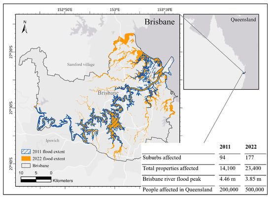
Figure 1.
Study area, flood extent, flood peak, number of suburbs, and people affected by floods in 2011 and 2022 [30,35,36].
2.2. Impact Assessment
2.2.1. Land-Use Classification
Different land-cover types have different values in the ecosystem and the society. The dataset of Queensland land use published by the Department of Environment and Science includes 32 land-cover types, which are classified according to the Australian Land Use and Management Classification. In this study, 15 land-cover types that appear in the Brisbane City Council area were selected and merged into 10 representative types using ArcGIS Pro 3.0.3 software (Table 1; Figure 2). The merged Brisbane land-use map includes open water, forest, wetlands, barren land, grass/rangelands, agriculture, residential, commercial, industrial, and other services. The land-cover map will be intersected with the flood extent of 2011 and 2022 in order to identify the land use of inundated areas and evaluate the level of socio-economic and ecological impacts in each land type.

Table 1.
Land-cover classes used in this study.
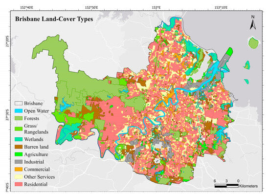
Figure 2.
Merged Brisbane land-cover map.
2.2.2. Economic Loss
The assessment of economic loss from floods is a quantitative evaluation of the adverse impacts on properties [37]. The property affected by floods is commonly divided into tangible and intangible assets. Tangible assets can be easily estimated in monetary terms [38]. Intangible assets cannot be easily assigned a dollar value since intangible damages occur when there are impacts that have no direct economic market [14]. For simplicity and practicality, in this paper, the most valuable tangible assets (buildings, equipment, crops, etc.) were selected to estimate the direct economic loss for urban areas and agricultural areas from floods.
There are various factors that affect flood damage, such as area of flooding, flow velocity, depth of flooding, duration of flooding, time of occurrence, rate of rise of flood water, water quality, and warning time [14,37,39,40]. Water depth is one of the commonly used. The Queensland Reconstruction Authority [41] gave different unit damage values of flood events at the water depths of 0.5 m and 1.5 m for different land uses. In order to improve the accuracy of this assessment, the water depths from 0 m to 1.5 m were further divided into 6 equal intervals, and the corresponding unit damage values were calculated. The water depth was calculated based on the data extracted from Flood Awareness Online by the Brisbane City Council records on historic flood height and floor height of buildings in Brisbane.
The flood depth map was interpolated from extracted depth points using a natural neighbor technique. Natural neighbor interpolation is considered a simple and fast algorithm for constructing grid digital elevation models from massive point clouds [42]. The algorithm finds the closest subset of input samples to a query point and applies weights to them based on proportionate areas to interpolate a value [43]. The equations are as follows:
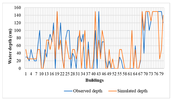
where is the estimated value for the surface at x, are the known depth data at , is the volume of the new cell centered at x, and is the volume of the intersection between the new cell centered at x and the old cell centered at . In this study, a total of 1600 depth points were interpolated in two steps to improve the efficiency and accuracy of interpolation. First, rough interpolation was carried out within the flood extent to determine the regions with flood depths of zero and greater than zero. The zero occurs because the height of the buildings was taken into account for accurate assessment. Second, a more intensive interpolation was performed in the regions where the water depth was not zero. These sampling points were distributed as evenly as possible in the floodplain. Water depth data of 80 buildings located on the estimated surface were extracted randomly for validation purposes. Nash–Sutcliffe efficiency coefficient (NSE), percent bias (PBIAS), and coefficient of determination (R2) were used to validate the simulated water depth with observed data obtained from Flood Awareness Online.
where is the observed water depth data, is the simulated water depth, is the average observed water depth, and is the average simulated water depth. Then, the economic losses for different land-cover classes at different water depths can be calculated (Table 2). For residential, commercial, industrial, other services, and agriculture land, the economic losses were calculated as follows:

Table 2.
The unit value of flood-induced gain and loss for different land-cover types.
- D = ;
- A = ;
- p = % of urban building-covered surface in a land-use type.
We randomly sampled 5% of each land-use area within the inundated area and outlined the buildings on satellite imagery. The percentage of urban fabric coverage of a land-use type was calculated through the area of building coverage and the area of the sample area.
Economic losses to open waters, forests, wetlands, barren lands, and grasslands were taken to be zero because there were not any tangible assets in these regions.
2.2.3. Ecological Gain
The ecological gain by floods was quantified as the values of ecosystem service in each land type. Sannigrahi et al. [44] explained ecosystem service value is the monetary value of an ecosystem and its key ecosystem goods and services. Thus, the ecological gain from floods can be quantified as the values of ecosystem service. The ecosystem service value given by Costanza et al. [45] was widely recognized since 1997; they estimated both the market and non-market components of the value of ecosystem services. De Groot et al. [46] then evaluated the ecosystem service values of 10 main biomes and created an ecosystem services value database that stored 300 case study locations. In 2014, Costanza et al. provided an updated estimate based on de Groot et al.’s study and land-use change. Their updated data were widely used in subsequent studies. In this paper, Costanza et al.’s ecosystem service value [47] was adopted to represent the level of unit ecological gain in five flood-affected land-cover types: open waters, forests, wetlands, barren lands, and grass/rangelands (Table 2). The values were converted into Australian dollars at the 2020 average exchange rate. The ecological gains of five land-cover types were calculated by unit gain and inundation area. The equation is as follows:
2.2.4. Social Losses
For social losses, intangible damages and losses, including loss of life, injury, diseases, stress, and anxiety, were considered [48]. These effects can be measured in terms of mortality, morbidity, value of life, and willingness to pay (Table 2). According to the data given by the Queensland Reconstruction Authority [41], mortality refers to the loss of life as a direct result of flooding, which is 0.31 deaths per 100,000 people in Queensland. In 2020 Australian dollars, the value of a statistical life is currently around $4.65 million. Morbidity is a maximum of $268 for a household willing to pay for injury, stress, mental health, and other health-related impacts. The number of people affected by floods in each suburb was determined by the total resident population in a suburb and the ratio of the inundated area to the suburb area. Estimated resident population by statistical area level 2 (SA2) in 2011 and 2021 was adopted to assess the social costs associated with flooding in each suburb. According to the Australian Bureau of Statistics, the average number of people per household in Australia was 2.6 in 2011 and 2.5 in 2021. The social losses for a suburb were calculated as follows:
2.3. Analysis of the Relationship between Flood Gains and Losses and the Geographical Factors
This analysis focuses on identifying the spatial factors closely related to high flood impacts. This provides easy identification of the high-risk areas and helps the design of corresponding mitigation strategies. The elevation, direct distance to the river center, and the direct distance to the upstream river source were included. The digital elevation model (DEM) with a 25 m grid obtained from the Queensland Spatial Catalogue was converted to a polygon feature output in ArcGIS Pro 3.0.3 software. The polygons were then reclassified and combined in intervals of every 5 m between −2 m and 1000 m above sea level. An intersection analysis of reclassified DEM and flood extent in 2011 and 2022 was performed using the spatial intersect tool to extract the inundation area on reclassified DEM. The total value of economic loss, ecological gain, and social cost for each inundated elevation polygon were calculated by using the area-weighted polygon method based on the land-cover types.
where is the area of a land-cover type in a polygon, and is the value of flood impact for a land-cover type. Zones were set up every 100 m within a catchment of 2000 m from the river center in order to analyze the relationship between flood effects and distance to the river. The overall values of economic loss, ecological gain, and social loss for each zone were calculated by using the area-weighted polygon method shown above. In order to explore the difference in flood effects between up- and downstream, inundated regions were divided into 10 intervals from west to east along the Brisbane River. The five intervals near the inland (0–23,500 m) were upstream, and the other five intervals near the estuary (23,500–42,300 m) were downstream, which can distinctly reflect the changes and fluctuations of the upstream and downstream flood impacts. An area-weighted polygon method was also adopted to calculate the total value for an interval.
Non-linear regression analysis was then conducted to identify the relationships of flood impacts (economic and social losses and ecological gain) with the elevation, direct distance to river, and direct distance to upstream of river source, respectively, using the “nls” function from the “stats” package in R version 4.2.3. This analysis does not imply causal relationships but rather identifies the geographical factors that characterize the regions with high socio-economic losses and ecological gains to facilitate flood impact mitigation design. We recognize that there are other factors that contribute to the extent of flood impacts (e.g., area of flooding, flow velocity, depth of flooding, duration of flooding, time of occurrence, rate of rise of flood water, contamination, and debris loads of the flood water) [14,37,39,40].
A summary of the datasets used in this study and their websites is shown in Appendix A.
3. Results
3.1. Economic, Ecological and Social Impacts
3.1.1. Economic Loss
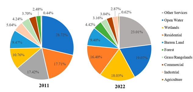
The total inundated area in the 2011 and 2022 floods was about 91 and 150 , around 17% and 16% of which were residential land exposed to economic losses, respectively (Figure 3, Appendix B). The total economic losses in 2011 and 2022 were estimated at $1.96 billion and $1.98 billion, respectively (Appendix C). In the 2011 flood, industrial land experienced the greatest economic loss, whereas commercial lands had the greatest losses in 2022. As shown in Figure 3, this was due to the fact that the 2011 flood inundation was concentrated in the south and the middle of Brisbane, whereas the 2022 flood was more widespread, with major economic losses occurring around the Brisbane River and its tributaries. In 2011, most suburbs suffered losses of less than $60 million, and two south Brisbane suburbs (Oxley, Rocklea) lost more than $120 million. In 2022, most of the suburbs had an economic loss within $50 million; Oxley, Rocklea, Deagon, and Gumdale lost more than $100 million. Finally, the validation of flood water depth shows that the simulated water depth is acceptable, with the coefficient of determination (R2) of 0.6, the Nash–Sutcliffe efficiency coefficient (NSE) of 0.58, and the percent bias (PBIAS) of −2.9% (see Appendix D for more details).
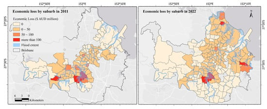
Figure 3.
Economic loss by suburb in the 2011 and 2022 flood events.
3.1.2. Ecological Gain
The overall ecological benefit in the 2022 flood (about $609 million) was estimated to be more than double than that in 2011 (about $251 million), as the inundated undeveloped area increased by 25 . A total of 46% and 45% of inundated regions achieved ecological gain in 2011 and 2022, respectively. Open water and wetlands, as the most valuable ecosystems, accounted for a large proportion of the total inundated area, resulting in the greatest ecological benefits. As a result of the difference in the natural landscape, the ecological gain showed obvious aggregation. During the 2011 flood event, ecological gains were concentrated along the Brisbane River, particularly in the Kholo and estuarine, areas where ecological gains were two to four times higher than in other suburbs (Figure 4). Most suburbs benefited from the floods in 2022, with major ecological gains concentrated in the coastal area and Kholo. Statistically, there were 17 suburbs achieved more than the average gain of 94 suburbs (around $2.67 million) in 2011, and 22 suburbs whose ecological benefits exceeded the average of 177 suburbs (about $3.44 million) in 2022.
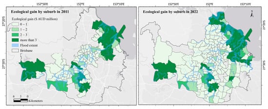
Figure 4.
Ecological gain by suburb in the 2011 and 2022 flood events.
3.1.3. Social Loss
Over 97,000 people in the Brisbane metropolitan were directly affected by the 2011 flood event, and this was even higher up to 187,000 in the 2022 flood event. The value of morbidity was estimated above $10 million and $20 million in the 2011 and 2022 floods, and the value of mortality was 1.4 million in 2011 and 2.7 million in 2022. The total social losses due to floods were $11.4 million and $22.7 million in 2011 and 2022, respectively (Figure 5). The suburbs with high social losses are mainly concentrated along the river. The suburbs located in the middle and south of Brisbane River (St Lucia, Rocklea–Acacia Ridge, New Farm, Indooroopilly, Chelmer–Graceville, West End) had the highest social losses (more than $416,000 per suburb) in 2011 and still had significant social costs in 2022. Due to the wider spread of the 2022 flood, additional significant social losses exceeding $606,000 were identified in Brisbane’s northeast suburbs (Newstead–Bowen Hills, Bald Hills, Wynnum West–Hemmant).
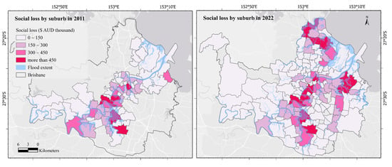
Figure 5.
Social loss by suburb in the 2011 and 2022 flood events.
3.2. The Relationship between Flood Impacts and the Geographical Factors
3.2.1. Elevation
Gaussian relationships indicating a bell-shaped development were identified for all economic, social, and ecological flood impacts with the elevation (Figure 6). The bell shapes were skewed to the left, indicating higher impacts at lower elevations (below 15 m). While the maximum economic losses (represented by the A coefficient in Figure 6d) were similar for the 2011 and 2022 floods ($1073.1 million in 2011 and $1141.05 million in 2022) (Figure 6a), the social losses and ecological gains (Figure 6b,c) were much higher for the 2022 floods (1.99 times higher for social and 2.43 higher for ecological). On the other hand, the maximum economic loss was reached at an elevation of approximately 8 m (i.e., the m coefficient) for the 2022 flood and close to 10 m for the 2011 flood, whereas the maximum social losses (at about 7 m) and ecological gains (at about 4.5 m) were reached at similar elevations for the 2011 and 2022 floods. Additionally, the extent of economic losses was comparatively more widely distributed across various elevations (represented by a greater d coefficient) for the 2022 flood, but the social losses and ecological gains were more dispersive for the 2011 flood. Finally, both economic and social losses tend to zero beyond an elevation of 20 m, whereas the ecological gains decrease more rapidly and reach zero at about 15 m.
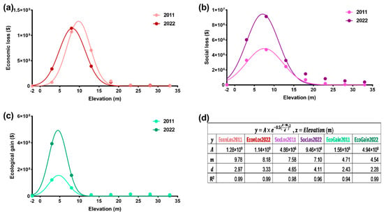
Figure 6.
The relationships between the elevations in Brisbane and the (a) economic loss, (b) social loss, (c) ecological gain, and (d) their regression coefficients in the 2011 and 2022 floods in Brisbane.
3.2.2. Direct Distance to the River
Exponentially decaying relationships were identified for all economic, social, and ecological flood impacts with the distance to the river (Figure 7). The economic losses in 2022 were smaller closer to the river (within 800 m) compared to that in 2011 and greater beyond 800 m (Figure 7a), whereas the social losses (Figure 7b) and ecological gains (Figure 7c) were consistently greater for the 2022 floods than that in 2011. The economic losses and ecological gains decayed more rapidly with distance to the river in the 2011 flood (1.99 times higher for social and 2.43 higher for ecological), whereas similar decay rates were identified for the social losses in 2011 and 2022 (represented by the k coefficient in Figure 7d). Additionally, the economic losses were identified across all distances (i.e., the smallest decay rates), but the social losses and ecological gains decayed to zero at about 250 m and 1250 m, respectively.
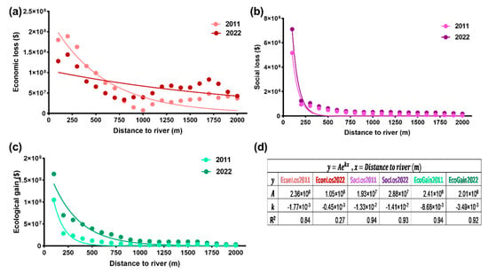
Figure 7.
The relationships between the distance to the Brisbane River and the (a) economic loss, (b) social loss, (c) ecological gain, and (d) their regression coefficients in the 2011 and 2022 floods in Brisbane.
3.2.3. Direct Distance to the Upstream River Source
Gaussian relationships indicating bell-shaped development were identified for all economic, social, and ecological flood impacts with the distance to the upstream river (Figure 8). It is not surprising that the shapes were skewed toward the right, indicating that the most significant impacts were concentrated at longer distances upstream of the Brisbane River. While the maximum economic losses (represented by the A coefficient in Figure 8d) were higher for the 2011 flood ($1187 million in 2011 and $763 million in 2022) (Figure 8a), the social losses and ecological gains (Figure 8b,c) were much higher for the 2022 floods (1.99 times higher for social and 2.43 higher for ecological). The maximum economic losses (30,000 m), social losses (30,000 m), and ecological gains (40,000 m) were reached at similar distances to the upstream river sources (i.e., the m coefficient) for the 2011 and 2022 floods. Additionally, the extents of economic losses, social losses, and ecological gains were all more widely distributed across various distances upstream (represented by a greater d coefficient) for the 2022 flood. It should also be noted that there is an additional peak for ecological gain (therefore relatively poor model fit) smaller 10,000 m upstream due to differences in natural landscape distribution.
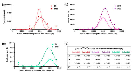
Figure 8.
The relationships between the distance to the upstream of the Brisbane River and the (a) economic loss, (b) social loss, (c) ecological gain, and (d) their regression coefficients in the 2011 and 2022 floods in Brisbane.
4. Discussion
This study developed a simple and integrated approach for spatially assessing the economic loss, ecological gain, and social cost in which the 2011 and 2022 floods in Brisbane were taken as case studies. The current studies of flood impact spatialization focus on assessing flood risk level rather than directly estimating flood impact in monetary value [4,5,12,25,49,50,51]. Compared to the existing flood assessment methods, this approach has the following strengths: (1) It provides a method to assess multiple flood impacts in monetary units, further supporting cost-benefit analysis in flood management decisions. (2) It incorporated the ecological gains into the assessment and thus could be used to support the urban green infrastructure planning and design by identifying potentially flood-beneficial regions (open water, forest, wetlands, barren land, grass/rangelands) [52,53]. (3) It spatially assessed the socio-economical losses at 25 m grid level and identified the relations between the flood impacts (ecological gain, socio-economic losses) and geographical factors (the elevation, direct distance from the river centerline, and direct distance to upstream river source). This approach supports community-driven flood mitigation, particularly for flood warning and preparation, by providing a simple, easy-to-use, spatially associated community assessment tool.
The key findings on the 2011 and 2022 flood events in Brisbane are summarized as follows:
- Downstream (above 23,500 m from the upper stream) riverside communities (within 800 m of the river) with low altitudes (below 15 m) are more likely to experience significant flood damage.
- Total economic losses in Brisbane were estimated at $1.96 billion and $1.98 billion in 2011 and 2022, respectively, which were consistent with former reports. Total ecological gains were approximately $251 million in 2011 and $609 million in 2022. Total social losses were $11.4 million and $22.7 million in 2011 and 2022, respectively.
- Flood impacts had a bell-shaped development with elevation. Regions with elevation below 15 m above sea level were most prone to be impacted. Flood impacts exponentially decayed with the distance to the river. Regions within 800 m of the Brisbane River were most prone to be impacted. Flood impacts had a bell-shaped development with distance to the upper stream of the river. Regions above 23,500 m from the upper stream were more prone to be impacted.
The government reports attest to the reliability of those findings. Queensland Reconstruction Authority [29] indicated that residential and commercial damage represents the highest tangible financial cost of the 2022 flood event, which was consistent with our findings. Damage to residential, commercial, public infrastructure, and agriculture cost approximately $2.74 billion in the 2022 South East Queensland rainfall and flooding event [29]. The Insurance Council of Australia [54] revealed the damage of the 2011 flood event was $2.38 billion across Queensland. Brisbane can be assumed to account for more than half of the total losses in Queensland flood events. This is because most of the Brisbane River catchment is rural (forestry and grazing land) and only includes the major metropolitan areas of Brisbane and Ipswich, as well as some smaller townships [28]. Ipswich is less than 7% of the area of Brisbane and only has a population of 242,653. In terms of Brisbane, it has the largest population, the highest asset values, and the highest residential density in Queensland, accounting for 46.4% of Queensland’s gross state product (GSP) [55]. Thus, the economic loss in Brisbane should be $1.19~2.38 billion in 2011 and $1.37~2.74 billion in 2022, which proves the reliability of estimated economic losses in this paper.
We estimated that over 97,000 people in the Brisbane metropolitan were directly affected by the 2011 flood event and up to 187,000 in the 2022 flood event. This number will be greater when considering the entire inundated region in Queensland. The current reports showed that more than 200,000 people were affected by the 2011 Queensland floods [56]; the 2022 flood affected more than double that number [35], which was consistent with our estimation. The mortality due to the floods in both years was estimated at one person in Brisbane. It is evidenced that Queensland Courts [57] reported a total of twenty-five deaths in Queensland; one death occurred at Durack in the southwest of Brisbane during the 2011 flood event and no loss of life as a result of the 2022 flood event [58]. Hence, the social losses calculated in this paper based on morbidity and mortality were reliable.
It should be noted that, besides the geographical factors, the climatic and hydrological factors also contribute to the flood impact, although beyond the community’s control. Appendix E shows the spatial distribution of average monthly rainfall (January to March) in Brisbane. The precipitation mainly concentrated to the west and north of Brisbane and showed a decreasing trend from inland to coastal regions. The rainfall resulted in the largest inflows into Wivenhoe Dam, which was situated on the upper Brisbane River to the northwest of Brisbane. In order to maintain the safety of the Dam and prepare for an incoming flood, Wivenhoe Dam released massive amounts of stored floodwater. Hydrologists appointed by the Insurance Council of Australia to investigate events leading to flood damage claims in Lower Brisbane River consider the Brisbane flood event to be a dam release flood [28]. This means that Brisbane’s flooding comes mainly from the release of water from the Dam. Seqwater [59] estimated that the peak flood height measured near Brisbane City would be about 2 m higher than experienced without the mitigating effects of Wivenhoe Dam. In 2022, precipitation was mainly concentrated in central Brisbane and presented a trend of first rising and then falling from the inland to the coast regions. The 2022 rainfall event had two major differences from the 2011 event. First, it had heavier rainfall and thus resulted in a larger inundated area. Secondly, the rainfall was more concentrated in Brisbane, and hence, the 2022 flood event was a rainfall flood. In other words, intense rainfall was a key reason for riverine flooding across large areas of Southeast Queensland in 2022 [60]. Therefore, to incorporate the spatial distribution of climatic and hydrological factors into this integrated assessment approach is a future direction.
This study has several limitations. The calculation of economic loss in this study was based on inundated building area, land covers, and water depth; however, the building footprint data cannot be extracted from available free satellite imagery. We replaced it by applying the building coverage rate, which reduced the accuracy of the estimated damage value. This study adopted relatively rough monetary values to assess the economic, social, and ecological impact, particularly because there are a lot of variations and uncertainties in the ecosystem services used to assess the ecological gains. Therefore, the approach can be mainly used to support community-driven flood mitigation and urban land-use planning rather than flood loss claims after a disaster. Qualitative studies, including semi-structured interviews with the local people, as well as environmental valuation studies, are also the direction of future research to complement the current method and provide a more accurate value for social costs and ecological gains.
5. Conclusions
The findings have implications for future flood management and urban land-use planning. Flood control infrastructure can be built at the community level according to the spatial distribution of flood damages and benefits, rather than just large hydraulic projects such as dams for the whole river basin, so as to increase the community’s flood storage and discharge channels. The resulting maps allow for the identification of suburbs with large exposure to damage, leading to potentially higher risk. Communities with high economic losses (mostly located in Rocklea, Oxley, Deagon, and Gumdale) should strengthen property protection, and economic losses can be minimized by raising the height of buildings and improving the drainage system. Communities with high potential social losses (located in St Lucia, Rocklea–Acacia Ridge, New Farm, Indooroopilly, Chelmer–Graceville, West End, Newstead–Bowen Hills, Bald Hills, and Wynnum West–Hemmant) should be given more attention to flood control and disaster relief. On the other hand, trade-offs should be considered with ecological gains in the natural landscapes that benefit from the floods (located in Kholo, Murarrie, Ransome, Lytton, Chuwar, Port of Brisbane, Nudgee Beach, Pinkenba, Brisbane Airport, and Bald Hills). These areas can act as temporary flood storage and reduce flood velocity through lake dredging, river widening, and tree planting, thereby enhancing ecological gains and reducing economic losses. The results of this study show that the inundated urban area is similar to the inundated natural land cover. This means Brisbane may have sufficient capacity to adapt to flooding, further minimizing economic loss and maximizing ecological gain.
In conclusion, this study developed a simple and integrated approach for spatially assessing the economic loss, ecological gain, and social cost, providing a three-dimensional perspective of flood impact analysis which takes into consideration the horizontal (direct distance to the river and direct distance to upstream river source) as well as the vertical dimensions (the elevation) of geographical space. As the incidence of urban flooding increases with global warming and urbanization, flood hazard has become a key issue in the lowlands, and this approach has implications for formulating urban land use and community-tailored mitigation strategies in Brisbane and other coastal cities globally.
Author Contributions
Conceptualization, Y.W., J.L., S.W. and Y.H.; methodology, Y.H., Y.W., J.L. and S.W.; software, Y.H. and S.W.; validation, Y.H.; formal analysis, Y.H. and S.W.; resources, Y.H.; data curation, Y.H. and S.W.; writing—original draft preparation, Y.H.; writing—review and editing, Y.W., S.W. and J.L.; visualization, Y.H. and S.W.; supervision, Y.W. All authors have read and agreed to the published version of the manuscript.
Funding
This research received no external funding.
Data Availability Statement
The raw data can be obtained through public websites, and the analyzed data used in this study can be accessed by contacting the corresponding author upon reasonable request.
Acknowledgments
The authors would like to thank the editor and the anonymous reviewers for their comments, which helped improve the quality of the paper.
Conflicts of Interest
The authors declare no conflict of interest.
Appendix A. The Summary of Datasets Used in This Study
The 2011 and 2022 Brisbane flood extents were taken from the Brisbane Open Data website, representing the maximum inundation line of the 2011 and 2022 flood events. Queensland local government area boundaries were used to identify the location of suburbs in Brisbane. The dataset of Queensland land use published by the Department of Environment and Science was used to identify the land-cover types in the Brisbane City Council area affected by the 2011 and 2022 floods. Estimated resident population by statistical area level 2 (SA2) is the smallest area for non-census and intercensal statistics published by the Australian Bureau of Statistics [61], which was used to assess the social costs associated with flooding in each suburb. Brisbane digital elevation model with a 25 m grid obtained from the Queensland Spatial Catalogue was used to analyze the relationship between elevation and flood impacts. Historic flood heights and floor heights of buildings were obtained from the Brisbane City Council on Flood Awareness Online.

Table A1.
Datasets used in this study.
Table A1.
Datasets used in this study.
| Data Name | Source |
|---|---|
| 2011 Brisbane flood extent | Brisbane Open Data website https://data.gov.au/dataset/ds-dga-35dc2150-5c72-4427-871f-650336e9151a/details (accessed on 21 October 2023) |
| 2022 Brisbane flood extent | Brisbane Open Data website https://www.data.brisbane.qld.gov.au/data/dataset/flood_awareness_historic_brisbane_river_and_creek_floods_feb_2022 (accessed on 21 October 2023) |
| Queensland local government area boundaries | Queensland Spatial Catalogue https://qldspatial.information.qld.gov.au/catalogue/custom/detail.page?fid={3F3DBD69-647B-4833-B0A5-CC43D5E70699} (accessed on 21 October 2023) |
| Queensland land-use mapping | Department of Environment and Science, 2022 https://qldspatial.information.qld.gov.au/catalogue/custom/detail.page?fid={C3CD23AD-7101-4765-8BED-AFC2C5DF1F5F} (accessed on 21 October 2023) |
| Estimated resident population by statistical area, level 2, Queensland, 2011 to 2021 | Australian Bureau of Statistics https://www.abs.gov.au/statistics/people/population/regional-population/latest-release (accessed on 21 October 2023) |
| Brisbane digital elevation model—25 m | Queensland Spatial Catalogue https://qldspatial.information.qld.gov.au/catalogue/custom/detail.page?fid={337F0DF2-64CD-4E26-AD21-7C63AEC1769E} (accessed on 21 October 2023) |
| Historic flood heights and floor heights of buildings | Flood Awareness Online https://fam.brisbane.qld.gov.au/?page=Map---Standard (accessed on 21 October 2023) |
Appendix B. The Proportion of Each Land-Use Type to the Total Inundated Area
Appendix C. Estimated Economic Losses
| Landuse | Building Coverage Rate | Economic Loss ($) 2011 | Economic Loss ($) 2022 |
| Commercial | 27.64% | 390,276,778.63 | 353,902,831.84 |
| Residential | 12.92% | 1,075,092,897.38 | 1,328,089,687.34 |
| Industrial | 27.02% | 479,879,966.44 | 288,991,955.43 |
| Other services | 0.27% | 10,277,924.20 | 13,282,016.26 |
| Agriculture | 100% | 59,021.55 | 58,729.56 |
| Total economic loss | $1,955,586,588.19 | $1,984,325,220.43 | |
Appendix D. Water Depth Validation
Appendix E. Brisbane Monthly Rainfall Distribution (January to March in 2011 and 2022)
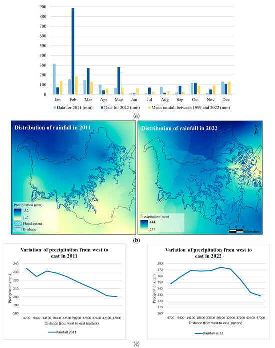
Figure A1.
(a) Brisbane monthly rainfall for 2011 and 2022 and Brisbane mean rainfall between 1999 and 2022 collected by Brisbane Climatological Station [62]. (b) Spatial distribution of average monthly rainfall (January to March in 2011 and 2022) in Brisbane. (c) Changes in precipitation from west to east during Brisbane flood events in 2011 and 2022.
References
- Queensland Government. Understanding Floods: Questions & Answers. 2011. Available online: https://www.chiefscientist.qld.gov.au/__data/assets/pdf_file/0022/49801/understanding-floods_full_colour.pdf (accessed on 21 October 2023).
- Konrad, C.P. Effects of Urban Development on Floods. U.S. Geological Survey–Water Resources. 2003. Available online: https://pubs.usgs.gov/fs/fs07603/pdf/fs07603.pdf (accessed on 21 October 2023).
- Hammond, M.J.; Chen, A.S.; Djordjević, S.; Butler, D.; Mark, O. Urban flood impact assessment: A state-of-the-art review. Urban Water J. 2015, 12, 14–29. [Google Scholar] [CrossRef]
- Garro-Quesada, M.d.M.; Vargas-Leiva, M.; Girot, P.O.; Quesada-Román, A. Climate Risk Analysis Using a High-Resolution Spatial Model in Costa Rica. Climate 2023, 11, 127. [Google Scholar] [CrossRef]
- Quesada-Román, A. Landslides and floods zonation using geomorphological analyses in a dynamic catchment of Costa Rica. Rev. Cartogr. 2021, 102, 125–138. [Google Scholar]
- NSW Government. Climate Change Impacts on Storms and Floods. 2022. Available online: https://www.climatechange.environment.nsw.gov.au/storms-and-floods (accessed on 21 October 2023).
- U.S. Department of Health and Human Services. Coastal Flooding, Climate Change, and Your Health What You Can Do to Prepare. 2017. Available online: https://www.cdc.gov/climateandhealth/pubs/CoastalFloodingClimateChangeandYourHealth-508.pdf (accessed on 21 October 2023).
- Hallegatte, S.; Green, C.; Nicholls, R.J.; Corfee-Morlot, J. Future flood losses in major coastal cities. Nat. Clim. Chang. 2013, 3, 802–806. [Google Scholar] [CrossRef]
- Vousdoukas, M.I.; Mentaschi, L.; Voukouvalas, E.; Bianchi, A.; Dottori, F.; Feyen, L. Climatic and socioeconomic controls of future coastal flood risk in Europe. Nat. Clim. Chang. 2018, 8, 776–780. [Google Scholar] [CrossRef]
- Cea, L.; Costabile, P. Flood risk in urban areas: Modelling, management and adaptation to climate change. A review. Hydrology 2022, 9, 50. [Google Scholar] [CrossRef]
- Power, S.B.; Callaghan, J. The frequency of major flooding in coastal southeast Australia has significantly increased since the late 19th century. J. South. Hemisph. Earth Syst. Sci. 2016, 66, 2–11. [Google Scholar] [CrossRef]
- He, Y.; Manful, D.; Warren, R.; Forstenhäusler, N.; Osborn, T.J.; Price, J.; Jenkins, R.; Wallace, C.; Yamazaki, D. Quantification of impacts between 1.5 and 4 C of global warming on flooding risks in six countries. Clim. Chang. 2022, 170, 15. [Google Scholar] [CrossRef]
- Djordjević, S.; Butler, D.; Gourbesville, P.; Mark, O.; Pasche, E. New policies to deal with climate change and other drivers impacting on resilience to flooding in urban areas: The CORFU approach. Environ. Sci. Policy 2011, 14, 864–873. [Google Scholar] [CrossRef]
- Haines, P.; Dearnley, C.; Wallace, S.; Ramilo, N.; Rodgers, B.; Filer, B.; Monhartova, P.; Kime, S.; McGuire, S.; Corkill, D.; et al. Technical Evidence Report—Brisbane River Strategic Floodplain Management Plan. 2018. Available online: https://cloudstor.aarnet.edu.au/plus/s/o7L0vJD0Uo5UO4B (accessed on 21 October 2023).
- Deloitte Access Economics. The Economic Cost of the Social Impact of Natural Disasters. 2016. Available online: http://australianbusinessroundtable.com.au/assets/documents/Report%20-%20Social%20costs/Report%20-%20The%20economic%20cost%20of%20the%20social%20impact%20of%20natural%20disasters.pdf (accessed on 21 October 2023).
- World Meteorological Organization. Environmental Aspects of Integrated Flood Management. 2006. Available online: https://www.floodmanagement.info/publications/policy/ifm_env_aspects/Environmental_Aspects_of_IFM_En.pdf (accessed on 21 October 2023).
- Peters, D.L.; Caissie, D.; Monk, W.A.; Rood, S.B.; St-Hilaire, A. An ecological perspective on floods in Canada. Can. Water Res. J. 2016, 41, 288–306. [Google Scholar] [CrossRef]
- Kalischuk, A.R.; Rood, S.B.; Mahoney, J.M. Environmental influences on seedling growth of cottonwood species following a major flood. For. Ecol. Manag. 2001, 144, 75–89. [Google Scholar] [CrossRef]
- Górski, K.; De Leeuw, J.J.; Winter, H.V.; Khoruzhaya, V.; Boldyrev, V.; Vekhov, D.A.; Nagelkerke, L.A.J. The importance of flooded terrestrial habitats for larval fish in a semi- natural large floodplain (Volga, Russian Federation). Inland Waters. 2016, 6, 105–110. [Google Scholar] [CrossRef]
- Australia Government. Australian Disaster Preparedness Framework. 2018. Available online: https://www.homeaffairs.gov.au/emergency/files/australian-disaster-preparedness-framework.pdf (accessed on 21 October 2023).
- Hallegatte, S.; Corfee-Morlot, J. Understanding climate change impacts, vulnerability and adaptation at city scale: An introduction. Clim. Chang. 2011, 104, 1–12. [Google Scholar] [CrossRef]
- Kazama, S.; Sato, A.; Kawagoe, S. Evaluating the cost of flood damage based on changes in extreme rainfall in Japan. Sustain. Sci. 2010, 4, 61–69. [Google Scholar] [CrossRef]
- Nafari, R.H.; Ngo, T.; Mendis, P. An assessment of the effectiveness of tree-based models for multi-variate flood damage assessment in Australia. Water 2016, 8, 282. [Google Scholar] [CrossRef]
- Jiménez-Jiménez, S.I.; Ojeda-Bustamante, W.; Ontiveros-Capurata, R.E.; Marcial-Pablo, M.D.J. Rapid urban flood damage assessment using high resolution remote sensing data and an object-based approach. Geomat. Nat. Hazards Risk 2020, 11, 906–927. [Google Scholar] [CrossRef]
- Pinos, J.; Quesada-Román, A. Flood risk-related research trends in Latin America and the Caribbean. Water 2021, 14, 10. [Google Scholar] [CrossRef]
- Chen, Y.; Zhou, H.; Zhang, H.; Du, G.; Zhou, J. Urban flood risk warning under rapid urbanization. Environ. Res. 2015, 139, 3–10. [Google Scholar] [CrossRef]
- Handayani, W.; Chigbu, U.E.; Rudiarto, I.; Putri, I.H.S. Urbanization and Increasing flood risk in the Northern Coast of Central Java—Indonesia: An assessment towards better land use policy and flood management. Land 2020, 9, 343. [Google Scholar] [CrossRef]
- Van den Honert, R.C.; McAneney, J. The 2011 Brisbane Floods: Causes, Impacts and Implications. Water 2011, 3, 1149–1173. [Google Scholar] [CrossRef]
- Queensland Reconstruction Authority. The Social, Financial and Economic Costs of the 2022 South East Queensland Rainfall and Flooding Event. 2022. Available online: https://www.qra.qld.gov.au/sites/default/files/2022-07/dae_report_-_south_east_queensland_rainfall_and_flooding_event_-_8_june_2022.pdf (accessed on 21 October 2023).
- Brisbane City Council. Brisbane’s FloodSmart Future Strategy. 2023. Available online: https://www.brisbane.qld.gov.au/community-and-safety/community-safety/disasters-and-emergencies/be-prepared/flooding-in-brisbane/flood-strategy/brisbanes-floodsmart-future-strategy (accessed on 21 October 2023).
- Joint Flood Taskforce. Joint Flood Taskforce Report March 2011. Report Prepared for the Brisbane City Council. 2011. Available online: http://www.floodcommission.qld.gov.au/__data/assets/file/0017/6443/BCC_Attachment_13_-_Joint_Flood_Taskforce_Report_March_2011.pdf (accessed on 21 October 2023).
- Bureau of Meteorology. Flood Summary for Brisbane River at Brisbane—December 2010 and January 2011. 2011. Available online: http://www.bom.gov.au/qld/flood/fld_reports/brisbane_fact_sheet_2011.pdf (accessed on 21 October 2023).
- Brisbane City Council. 2022 Brisbane Flood Review. 2022. Available online: https://www.brisbane.qld.gov.au/sites/default/files/documents/2022-06/20220623-Brisbane-Flood-Review-at-9-May-2022-tagged.pdf (accessed on 21 October 2023).
- Queensland Government. South East Queensland Rainfall and Flooding February to March 2022 Review. 2022. Available online: https://www.igem.qld.gov.au/sites/default/files/2022-10/PROTECTED%20SEQ%20Rainfall%20and%20Flooding%20Reviewreduced_0.pdf (accessed on 21 October 2023).
- Queensland Government. 2021–22 Southern Queensland Floods. 2022. Available online: https://www.qra.qld.gov.au/2021-22-Southern-Queensland-Floods (accessed on 21 October 2023).
- Queensland Reconstruction Authority. The State Community, Economic and Environmental Recovery and Reconstruction Plan 2011–2013. 2011. Available online: https://www.qra.qld.gov.au/sites/default/files/2020-03/Operation-Queenslander-implementation-plan.PDF (accessed on 21 October 2023).
- Hammond, M.; Djordjević, S.; Butler, D.; Chen, A.S. Flood Impact Assessment Literature Review. University of Exeter, United Kingdom, 15 August 2014. Available online: https://ore.exeter.ac.uk/repository/bitstream/handle/10871/21215/Flood%20Impact%20Assessment%20Literature%20Review.pdf?sequence=1 (accessed on 21 October 2023).
- Messner, F.; Evaluating Flood Damages: Guidance and Recommendations on Principles and Methods. Helmholz Unweltforschungszentrum (UFZ). 2007. Available online: https://repository.tudelft.nl/islandora/object/uuid%253A5602db10-274c-40da-953f-34475ded1755 (accessed on 21 October 2023).
- Merz, B.; Kreibich, H.; Schwarze, R.; Thieken, A. Review article “Assessment of economic flood damage”. Nat. Hazards Earth Syst. Sci. 2010, 10, 1697–1724. [Google Scholar] [CrossRef]
- Kundzewicz, Z.W.; Kanae, S.; Seneviratne, S.I.; Handmer, J.; Nicholls, N.; Peduzzi, P.; Mechler, R.; Bouwer, L.M.; Arnell, N.; Mach, K.; et al. Flood risk and climate change: Global and regional perspectives. Hydrol. Sci. J. 2014, 59, 1–28. [Google Scholar] [CrossRef]
- Queensland Reconstruction Authority. Economic Assessment Framework of Flood Risk Management Projects. 2021. Available online: https://www.qra.qld.gov.au/sites/default/files/2021-05/economic_assessment_framework_of_flood_management_projects_2021_0.pdf (accessed on 21 October 2023).
- Beutel, A.; Mølhave, T.; Agarwal, P.K. Natural neighbor interpolation based grid DEM construction using a GPU. In Proceedings of the 18th SIGSPATIAL International Conference on Advances in Geographic Information Systems, New York, NY, USA, 2–5 November 2010; pp. 172–181. [Google Scholar] [CrossRef]
- Sibson, R. Chapter 2 Interpolating Multivariate Data. In A Brief Description of Natural Neighbor Interpolation; John Wiley & Sons: New York, NY, USA, 1981; pp. 21–36. [Google Scholar]
- Sannigrahi, S.; Chakraborti, S.; Joshi, P.K.; Keesstra, S.; Sen, S.; Paul, S.K.; Kreuter, U.; Sutton, P.C.; Jha, S.; Dang, K.B. Ecosystem service value assessment of a natural reserve region for strengthening protection and conservation. J. Environ. Manag. 2019, 244, 208–227. [Google Scholar] [CrossRef] [PubMed]
- Costanza, R.; d’Arge, R.; De Groot, R.; Farber, S.; Grasso, M.; Hannon, B.; Limburg, K.; Naeem, S.; O’neill, R.V.; Paruelo, J.; et al. The value of the world’s ecosystem services and natural capital. Nature 1997, 387, 253–260. [Google Scholar] [CrossRef]
- De Groot, R.; Brander, L.; Van Der Ploeg, S.; Costanza, R.; Bernard, F.; Braat, L.; Christie, M.; Crossman, N.; Ghermandi, A.; Hein, L.; et al. Global estimates of the value of ecosystems and their services in monetary units. Ecosyst. Serv. 2012, 1, 50–61. [Google Scholar] [CrossRef]
- Costanza, R.; De Groot, R.; Sutton, P.; Van der Ploeg, S.; Anderson, S.J.; Kubiszewski, I.; Farber, S.; Turner, R.K. Changes in the global value of ecosystem services. Glob. Environ. Chang. 2014, 26, 152–158. [Google Scholar] [CrossRef]
- Olesen, L.; Löwe, R.; Arnbjerg-Nielsen, K. Flood Damage Assessment: Literature Review and Recommended Procedure. Cooperative Research Centre for Water Sensitive Cities, Melbourne, Australia. 2017. Available online: https://watersensitivecities.org.au/wp-content/uploads/2017/03/IN_PC956_B4-1_Flood_Damage_web.pdf (accessed on 21 October 2023).
- Quesada-Román, A. Disaster risk assessment of informal settlements in the Global South. Sustainability 2022, 14, 10261. [Google Scholar] [CrossRef]
- Reaney, S.M. Spatial targeting of nature-based solutions for flood risk management within river catchments. J. Flood Risk Manag. 2022, 15, e12803. [Google Scholar] [CrossRef]
- Ikirri, M.; Faik, F.; Echogdali, F.Z.; Antunes, I.M.H.R.; Abioui, M.; Abdelrahman, K.; Fnais, M.S.; Wanaim, A.; Id-Belqas, M.; Boutaleb, S.; et al. Flood hazard index application in arid catchments: Case of the taguenit wadi watershed, Lakhssas, Morocco. Land 2022, 11, 1178. [Google Scholar] [CrossRef]
- Liao, K.H.; Le, T.A.; Van Nguyen, K. Urban design principles for flood resilience: Learning from the ecological wisdom of living with floods in the Vietnamese Mekong Delta. Landsc. Urban Plan. 2016, 155, 69–78. [Google Scholar] [CrossRef]
- Hamel, P.; Tan, L. Blue–green infrastructure for flood and water quality management in Southeast Asia: Evidence and knowledge gaps. Environ Manag. 2022, 69, 699–718. [Google Scholar] [CrossRef] [PubMed]
- Australian Disaster Resilience. Queensland and Brisbane 2010/11 Floods. 2011. Available online: https://knowledge.aidr.org.au/resources/flood-queensland-2010-2011/#:~:text=The%20Insurance%20Council%20of%20Australia%20estimates%20the%202011%20damage%20at%20%242.38%20billion (accessed on 21 October 2023).
- Queensland Government. Experimental Estimates of Gross Regional Product. 2008. Available online: https://www.qgso.qld.gov.au/issues/3316/experimental-estimates-gross-regional-product-2005-06.pdf (accessed on 21 October 2023).
- McCall, B. Public Health Aspects of the Queensland Floods Dec 2010–Jan 2011. Pathology 2012, 44, S45–S46. [Google Scholar] [CrossRef]
- Queensland Courts. Inquest into the Deaths Caused by the South-East Queensland Floods of January 2011. 2012. Available online: https://www.courts.qld.gov.au/__data/assets/pdf_file/0019%252F152362%252Fcif-seq-floods-20120605.pdf (accessed on 21 October 2023).
- Brisbane City Council. Flood-Ex21 Local Recovery Plan. 2021. Available online: https://www.qra.qld.gov.au/sites/default/files/2022-10/Brisbane%20City%20Council%20-%20Local%20Recovery%20Plan%20-%20Southern%20Queensland%20Floods%202021-22.pdf (accessed on 21 October 2023).
- Seqwater. January 2011 Flood Event: Report on the Operation of Somerset Dam and Wivenhoe Dam. 2011. Available online: http://www.floodcommission.qld.gov.au/__data/assets/pdf_file/0017/4292/QFCI_Exhibit_24_January_2011_Flood_Event_Report_on_the_Operation_of_Somerset_and_Wivenhoe.pdf (accessed on 21 October 2023).
- Queensland Government. Review into the 2022 South East Queensland Rainfall and Flood Event. 2022. Available online: https://cabinet.qld.gov.au/documents/2022/Mar/IGEMReviewToR/Review%20into%20the%202022%20South%20East%20Queensland%20Rainfall%20and%20Flood%20event.DOCX (accessed on 21 October 2023).
- Australian Bureau of Statistics. Statistical Areas Level 2 (SA2). 2021. Available online: https://www.abs.gov.au/ausstats/abs@.nsf/Lookup/by%20Subject/1270.0.55.001~July%202016~Main%20Features~Statistical%20Area%20Level%202%20(SA2)~10014 (accessed on 21 October 2023).
- Bureau of Meteorology. Climate Statistics for Australian Locations. 2022. Available online: http://www.bom.gov.au/climate/averages/tables/cw_040842.shtml (accessed on 21 October 2023).
Disclaimer/Publisher’s Note: The statements, opinions and data contained in all publications are solely those of the individual author(s) and contributor(s) and not of MDPI and/or the editor(s). MDPI and/or the editor(s) disclaim responsibility for any injury to people or property resulting from any ideas, methods, instructions or products referred to in the content. |
© 2023 by the authors. Licensee MDPI, Basel, Switzerland. This article is an open access article distributed under the terms and conditions of the Creative Commons Attribution (CC BY) license (https://creativecommons.org/licenses/by/4.0/).