Article

Soil Moisture Distribution and Time Stability of Aerially Sown Shrubland in the Northeastern Margin of Tengger Desert (China)

1
College of Desert Science and Engineering, Inner Mongolia Agricultural University, Hohhot 010018, China
2
Yinshanbeilu National Field Research Station of Steppe Eco-Hydrological System, China Institute of Water Resources and Hydropower Research, Beijing 100038, China
3
Institute of Water Resources for Pastoral Area, Ministry of Water Resources, Hohhot 010020, China
*
Author to whom correspondence should be addressed.
Water 2023, 15(20), 3562; https://doi.org/10.3390/w15203562
Submission received: 13 September 2023 / Revised: 1 October 2023 / Accepted: 9 October 2023 / Published: 12 October 2023
(This article belongs to the Special Issue Remote Sensing-Based Study on Surface Water Environment)

Abstract

:
Considering the importance of soil moisture in hydrological processes, it is crucial to understand the water distribution and time stability of different aerial shrub soils. There are few studies on the soil moisture of aerial vegetation in the northeastern margin of the Tengger Desert. Based on long-term monitoring data from the aerial seeding area in the northeastern margin of the Tengger Desert, the distribution characteristics of soil moisture and the temporal stability of soil moisture were studied. From June to October 2022, the soil moisture monitoring instrument WatchDog was used to monitor the long-term soil moisture changes (0–200 cm) in the four aerial afforestation plots of Hedysarum scoparium, mixed forest land (Hedysarum scoparium dominant species), mixed forest land (Calligonum mongolicum dominant species), and Calligonum mongolicum. The Spearman rank correlation coefficient was used to study the temporal stability of soil moisture in the four plots. Rainfall data were collected through small weather stations. The results show that the average soil water storage of four kinds of aerial shrub land in the study area was the highest in August, and the average soil water storage of different forest lands was different. The soil water content of the surface layer (0–30 cm) fluctuated the most in different months. The variation in soil water content in the shallow layer (30–100 cm) was smaller than that in the surface layer. The fluctuation of soil water content in the middle layer (100–150 cm) and deep layer (150–200 cm) was relatively stable. There was no strong variability in soil moisture content, and the temporal variation coefficient of surface soil moisture was the highest (31.44–39.8%), which showed moderate variability. The temporal variation coefficient of soil moisture in the shallow, middle and deep layers of all kinds of plots was significantly reduced, and the soil moisture stability of different aerial shrub land was the same. Spearman rank correlation analysis showed that the spatial pattern of soil water content in the surface layer (0–30 cm) and deep layer (150–200 cm) was more stable over time, that is, the temporal stability of soil water content was higher, and the temporal stability of soil water content in the middle and shallow layers of different types of shrub land was different. The research results help us to understand the soil hydrological process in the aerial seeding afforestation area in the northeastern margin of Tengger Desert, rationally arrange soil moisture monitoring points, efficiently manage and utilize water resources in the aerial seeding area, and provide a theoretical basis for local vegetation restoration and the optimization of the ecological environment.

1. Introduction

Soil moisture is the main source of plant water, plays an important role in the material and energy conversion of the soil–vegetation–atmosphere system, and is the key factor in controlling the structure of an ecosystem [1,2]. For arid and semi-arid areas, due to the presence of less rainfall and large degrees of evaporation, soil moisture has become the core of ecosystem operation in this area. Soil moisture not only affects rainfall infiltration, evaporation, solute transport, runoff and sediment production, but also has close effects on and influence over soil texture, organic matter, topography, vegetation and human activities [3,4]. Therefore, soil moisture shows instability and variability in spatial and temporal distribution [5,6]. In this regard, in seeking to quickly obtain the average soil moisture status of a region, relevant studies have found that the spatial model of soil moisture has temporal stability, and the soil moisture of some monitoring points can represent the average status of the study area [1]. Further, all measurement points are arranged from small to large. Distinct measurements of some individual sample points always effectively represent the average soil moisture of the test site, while distinct measurements at other sample points will always be higher than or lower than the average soil moisture level of the entire plot. This phenomenon is defined as the temporal stability of soil moisture, and has been widely studied and applied. Its advantage is that it can help to optimize the number of sampling points, and enable us to quickly and accurately estimate the average soil moisture of a sample plot. The selected representative measuring points can be used to predict the average soil moisture in the study area. Therefore, when seeking to obtain the average soil moisture, a wide range of samples is no longer required, and only the soil moisture of the representative measuring points needs to be measured at a specific time point, which can save a lot of manpower and material resources. This phenomenon is defined as the temporal stability of soil moisture and has been widely studied and applied. At present, research on the temporal stability of soil moisture has gradually become the focus of many scholars. In recent years, many scholars have used the temporal stability of soil moisture in different scales [6,7,8] and different ecosystems [9,10]. Comegna and Basile et al. [11] found that there is no temporal stability of soil moisture in more homogeneous sandy volcanic soils. Penna et al. [12] studied the temporal stability of soil moisture in different soil layers of two alpine slopes under drought and wet conditions, and concluded that the soil moisture in the slopes had strong temporal stability and autocorrelation. Zhao [13] studied the dynamic characteristics of soil moisture stored in rock (ROC) environments, especially the spatial pattern of soil moisture (SMSP) and its temporal stability. The results show that the spatial heterogeneity of soil moisture was higher than that of other terrestrial ecosystems, but this area also maintained a high degree of temporal stability. Wang [14] and Gao [15] found that there were significant differences in the temporal stability of soil water content at different depths in the Loess Plateau. In addition, when scholars studied the influence of topography, vegetation and other factors on the temporal stability of soil water content, they found that when only geographical location and topography were considered, soil water showed a relatively stable spatial distribution structure over time, and when vegetation factors were added, the spatial distribution structure of soil water became unstable [16,17]. Y. Patrick Gbohou et al. [18] studied the climate and environmental changes in the Nakanb ‘e River watershed in the West Africa Sahel (WAS). The results show that climate and environmental changes have an impact on surface runoff in the Sahel region, further changing the state of soil moisture and thus affecting regional hydrological processes. Related studies have pointed out that vegetation characteristics affect the spatial distribution of soil moisture, and enhance or weaken the spatial heterogeneity of soil moisture to a certain extent [19,20,21]. However, different vegetation types have different demands as regards soil moisture, which leads to great differences in soil moisture characteristics under different vegetation types [22,23,24].
It has been more than 30 years since aerial seeding in 1992 in the northeastern margin of Tengger Desert. Before 1992, due to drought and overgrazing, the vegetation in the aerially seeded area declined and died, causing serious desertification. This, coupled with the forward movement of shifting sand, he fluctuating sand dunes were formed in the seeding area, accounting for 60% of the total seeding area. The vegetation coverage was less than 1%, and there was almost no vegetation growth. However, with the implementation of aerial seeding afforestation, vegetation restoration achieved remarkable results. With the survival of the aerial seeding vegetation types Hedysarum scoparium and Calligonum mongolicum, the vegetation coverage increased significantly. As shown in Figure 1, the overall vegetation coverage in the aerial seeding area has reached 20–30%. The increase in vegetation coverage has meant that the original moving dunes are now fixed or semi-fixed dunes, and the formation of soil crusts has improved the physical and chemical properties of the original soil, increasing the organic matter content, which has greatly improved the soil conditions. In addition, vegetation restoration has also improved the soil moisture conditions in the sowing area and actively promoted vegetation restoration. Aerial seeding afforestation has played a vital role in the ecological environment restoration of 92 planting areas, and the practice of aerial seeding afforestation, now undertaken for more than 30 years, has led to Hedysarum scoparium and Calligonum mongolicum becoming the main sandy shrub species in the study area, due to their strong ecological adaptability, as well as their windbreak and sand fixation abilities.
Artificial vegetation restoration can be enacted to select tree species with high survival rates and high economic benefits, as well as select suitable tree species according to local conditions. Another important contribution of artificial vegetation restoration is that it can supplement groundwater over a long period, especially through prioritization to further improve vegetation rooting depth, thereby promoting vegetation survival [25]. Soil moisture is one of the most important conditions for vegetation restoration, and important progress has been made in the study of soil moisture stability under different land use conditions in many regions. However, in recent years, with large-scale aerial seeding afforestation in the arid desert area of Northwest China, differences in soil moisture dynamics and time stability under different vegetation configuration modes in aerial seeding afforestation areas are rarely reported.
The temporal stability of soil moisture refers to the stability of the spatial distribution of soil moisture through time. It can be used to obtain representative measuring points of regional average soil moisture content, thus providing a convenient and effective approach to soil moisture monitoring and forecasting while ensuring the accuracy of soil moisture data. Artificial vegetation can better promote vegetation restoration in sandy areas. The reason for this is that artificial shrubs are more tolerant of and adaptable to abiotic factors such as drought and wind erosion, sand burial, and grazing interference. In the early stages of the establishment of sand-fixing vegetation, due to the low coverage of shrubs, sparseness of surface herbs, and the thin and small biological soil layers, sand-fixing vegetation can effectively use rainfall, and thus has little dynamic effects on deep soil moisture. With the increase in and development of shrub and herb coverage in vegetation, the interception of precipitation by the vegetation canopy has increased, and the thickening and evolution of biological crusts has significantly reduced precipitation infiltration. In addition, when rainfall is scarce or lacking, plants use a large amount of deep soil water, mainly derived from underground, as the roots of shrubs develop. The aerial seeding area of the Tengger Desert is a key area for vegetation restoration and construction. Artificially restored vegetation has greatly changed the soil moisture and vegetation characteristics of the region. How this huge disturbance affects the spatial and temporal heterogeneity and temporal stability of soil moisture remains to be studied.
Based on this, this study established a soil moisture observation point at the bottom of the windward slope of the fixed dune in the aerial seeding afforestation area in the northeastern margin of the Tengger Desert, and continuously monitored the soil moisture content of the shrub land covered by typical aerial seeding vegetation Calligonum mongolicum and Hedysarum scoparium from 0 to 200 cm. The temporal and spatial variation characteristics of soil moisture in different vegetation communities at different depths were analyzed. The temporal stability characteristics of soil moisture content were analyzed by Spearman rank correlation, and the temporal stability differences of soil moisture in four configuration modes were clarified. Understanding the temporal stability of soil moisture content at different depths is helpful to understanding what kind of sand-fixing vegetation configuration mode is suitable under the soil moisture conditions in a specific region, and to provide a scientific theoretical basis for the optimal allocation of vegetation and the construction of ecological environment stability in the region.

2. Materials and Methods
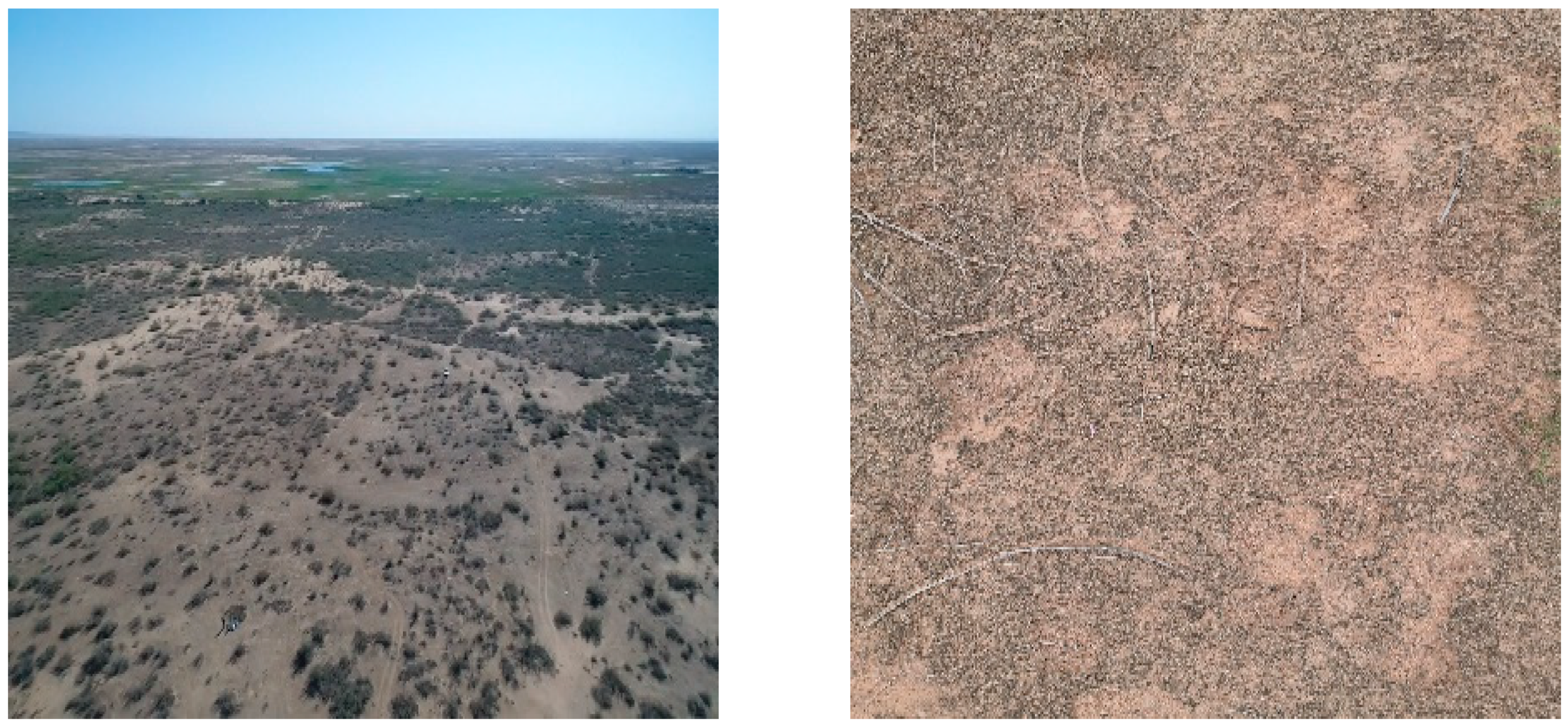
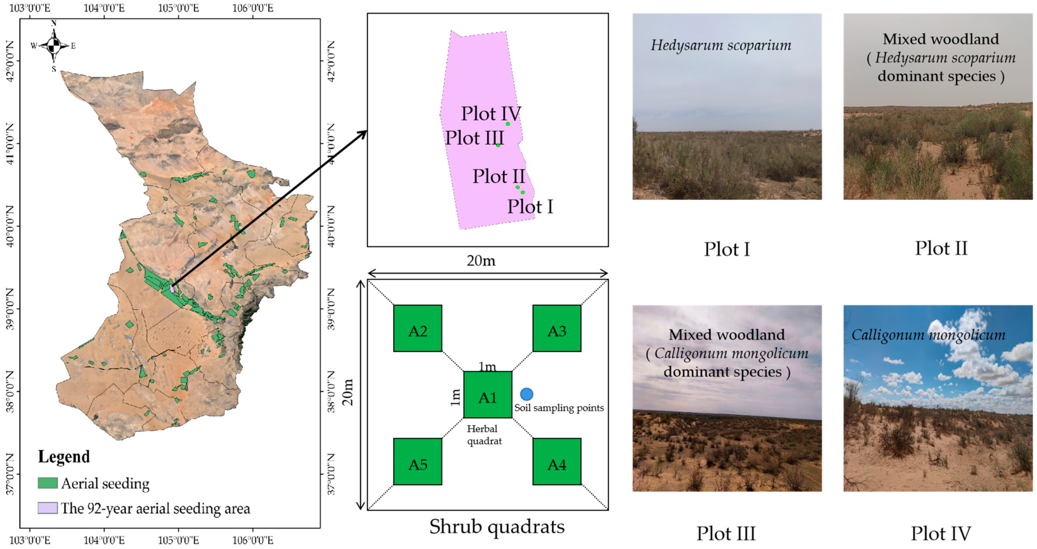
2.1. Study Area

This study was carried out from June to October 2022. The study area is located in the northeastern margin of the Tengger Desert in Alxa Left Banner. The aerial shrub forest area (39°11′–39°18′ N, 104°53′–104°57′ E) formed following the implementation of aerial afforestation in 1992. The area is 4025.33 hm2, and the average altitude is about 1265 m. The terrain is tilted from southeast to northwest. It belongs to the edge of the Helan Mountain alluvial fan. The terrain is open and the undulating dunes are connected. The surface wind erosion is strong. The soil types in the aerial seeding area are mainly gray desert soil and sandy soil [26]. The annual precipitation in this area is between 100 and 200 mm, with an average of 142.0 mm (2009–2020). The rainfall is mainly concentrated in June–September, accounting for about 62% of the whole year. The numbers of strong wind days in spring and winter are the most, the average annual wind speed is 7.1 m/s [27], and the maximum wind speed can reach 26 m/s. The average annual evaporation is 2258.8 mm, the frost-free period is 168 d/year, the light duration is 8.6 h/d, the solar radiation is 150 KJ/cm2, and the average annual temperature is 7.8 °C. The vegetation type is mainly composed of Hedysarum scoparium and Calligonum mongolicum.

2.2. Research Methods

2.2.1. Sample Plot Setting and Investigation

For soil moisture positioning monitoring, four plots were set up in the study area, and each plot featured a typical vegetation community from the bottom of the windward slope of the fixed dune (Table 1) as its research object. The soil moisture observation instrument was installed in June 2022, and the plot survey was carried out at the same time. Five 20 m × 20 m shrub quadrats were set up in each plot (Figure 2).
Before sampling, the basic information of each survey unit was recorded in the early stage, including soil characteristics such as soil crust coverage, soil bulk density and soil porosity, and vegetation characteristics such as shrub plant height, crown width, base diameter, density, and shrub and grass coverage. The location and plant composition information of each test plot were recorded during the investigation. The basic information of each experimental plot is shown in Table 1 and Table 2.

2.2.2. Sample Collection and Index Determination

Studies have shown that the roots of sand-fixing shrubs in the study area are mainly distributed in the 40–200 cm soil layer, which is the main layer of soil moisture [28]. Therefore, in this study, one standard aerial shrub plant was selected from each shrub quadrat, and a soil profile at a depth of 200 cm was manually dug under the plant. Soil moisture sensors were installed at 7 soil depths of 10 cm, 20 cm, 30 cm, 60 cm, 100 cm, 150 cm and 200 cm on the same side of the profile to observe the soil moisture content in real time. After the sensor was installed, the soil pit was backfilled, and the surface layer after backfilling was made as close as possible to the surrounding surface. The soil moisture was measured using a WatchDog (Spectrum Technologies, Aurora, IL, USA) data collector every 30 s, and the data were recorded at 15 min intervals. Meteorological data were automatically monitored by a small automatic weather station, recording atmospheric precipitation, temperature, wind speed, etc. (Table 3).

2.2.3. Data Processing

Calculation of Soil Water Storage

Soil water storage refers to the storage of soil moisture within a certain unit volume. In this study, the soil water storage per unit volume at a 0–200 cm soil depth was estimated according to the soil depth of 0–200 cm. Formulas (1) and (2) are shown below [29]:
S W S i = i = 1 7 S V W C i d i
S W C j ¯ = 1 7 i = 1 7 S W C i j
In the formula, SWSi is the water storage of the i-layer soil profile, SVWCi is the soil’s volumetric water content (m3/m3), di is the soil depth (mm), 7 is the number of soil layers observed in this study, and is S W C j ¯ is the average soil water content at time j (m3/m3).

Coefficient of Variation

The vertical variation coefficient was used to analyze the spatial variation characteristics of soil moisture in different vegetation types. In the formula, δ is the standard deviation and μ is the mean value.
C V = δ μ × 100 %
CV < 10% is weak variability; 10% ≤ CV ≤ 100% is moderate variability; CV ≥ 100% is strong variability [3].

Spearman Rank Correlation Coefficient

The Spearman rank correlation coefficient rs was used to analyze the stability of the ranks of different observation points over time in the growing season of 2022. It is calculated using the below formula [30]:
r s = 1 6 i = 1 n ( R i j R i l ) 2 n ( n 2 l )
In the formula, Rij is the rank of the soil water content value for the observation point i at the observation time j, Ril is the rank i of the measuring point l, and n is the total number of observation points. The closer rs is to 1, the more stable the spatial pattern of the soil water content is over time.
The statistical analysis applied in this paper was mainly performed using Excel and SPSS software, and the data mapping was carried out using Origin software.

3. Results and Analysis

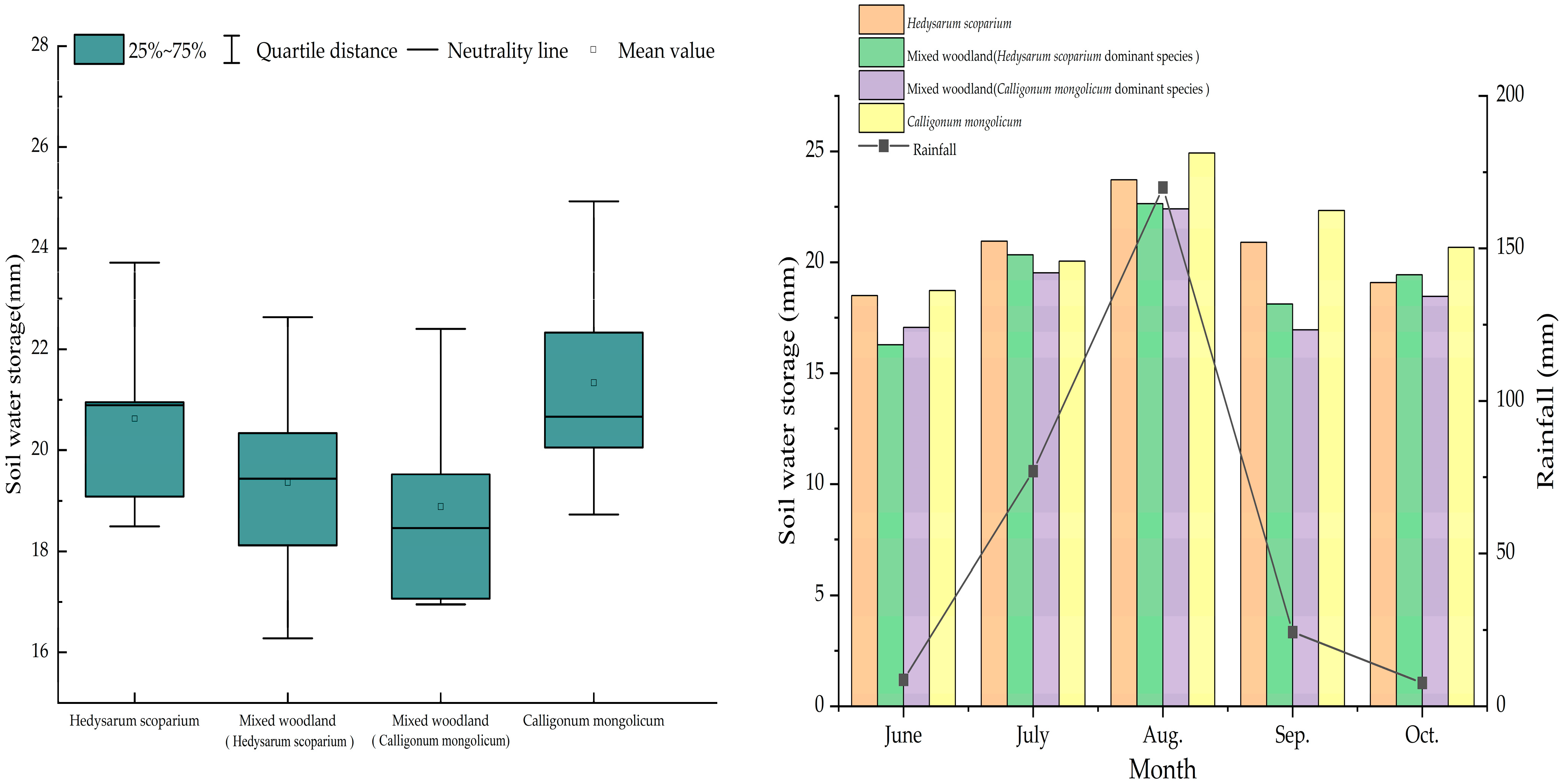
3.1. Soil Water Storage

As shown in Figure 3, from June to October 2022, the average soil water storage levels at the 0–200 cm layer of four kinds of aerial shrub land were between 18 and 21 mm. The average soil water storage levels of different aerial shrub land are as follows: Calligonum mongolicum forest land (21.34 mm) > Hedysarum scoparium forest land (20.63 mm) > mixed forest land (Hedysarum scoparium dominant species) (19.36 mm) > mixed forest land (Calligonum mongolicum dominant species) (18.88 mm). Comparing the soil water storage levels of the experimental plots in different months, it can be found that the soil water storage from June to October in the growing season was basically consistent with the trend of rainfall, and the average soil water storage in the study area reached the highest with rainfall in August. There were differences in the soil water storage of shrub land at different months with different aerial seeding types. In July, the soil water storage of Hedysarum scoparium shrub land was the highest (20.95 mm), while in June and August to October, the soil water storage of Calligonum mongolicum forest land was the highest, at 18.73 mm, 24.93 mm, 22.33 mm and 20.67 mm, respectively, indicating that soil water storage was mainly affected by rainfall.

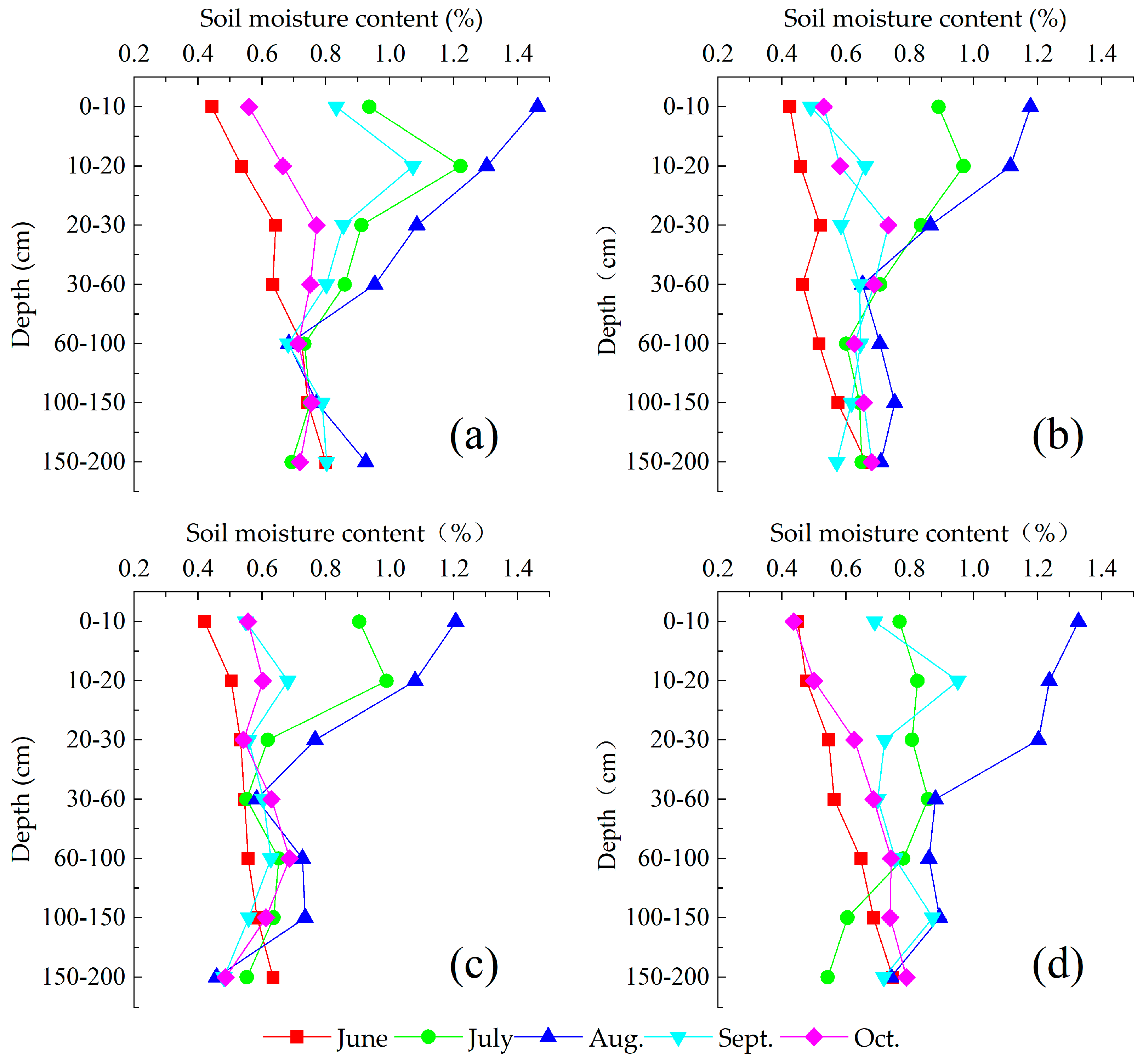
3.2. Spatial and Temporal Distribution Characteristics of Soil Moisture

The variation characteristics of soil moisture in the growing season of the four kinds of aerially sown shrublands are shown in Figure 4. The soil moisture contents in the 0–200 cm soil layer in the aerially sown area in different months show significant differences. Due to the scarce rainfall in June and before June, the strong level of soil evaporation mean that the surface soil moisture contents of the four kinds of aerially sown forest were less than 0.5%, and the soil moisture contents in different soil layers fluctuated only a little. In July and August, with the increase in rainfall, the average soil moisture contents of the four kinds of shrublands reached over 0.8%. Among these, in July, with the increase in soil depth, the soil water content showed a trend of increasing first and then decreasing. Among these, the soil water contents of Hedysarum scoparium forest land, mixed forest land (Hedysarum scoparium dominant species) and mixed forest land (Calligonum mongolicum dominant species) reached their maximum in the 10–20 cm soil layer, while the soil water content of Calligonum mongolicum forest land reached its maximum in the 30–60 cm soil layer. This result may be related to soil characteristics and the fine distribution of plant roots in the study area. In August, the average soil water content in the study area reached the highest value, and the change in surface soil water content was the most obvious. With the increase in soil depth, the soil water showed less fluctuation. Because the middle and deep layers were less affected by rainfall, the soil water contents below 100 cm in the four kinds of aerial shrub land did not change significantly at different times.
By comparing the soil moisture contents between different community plots (Figure 4a–d), it was found that the average soil moisture contents of the Hedysarum scoparium forest land were the highest among the four kinds of aerial seeding shrub lands, reaching 1.01%, and the average soil moisture content of the mixed forest land (Calligonum mongolicum dominant species) was 0.83%, which was the lowest compared with other shrub lands. In June, the average soil water content of the mixed forest land (Hedysarum scoparium dominant species) was the lowest, at 0.53%. The average soil water content of the Hedysarum scoparium forest land was the highest from July to August, at 0.83%. After September, the soil water contents of the Hedysarum scoparium forest land and the Calligonum mongolicum forest land showed a downward trend, while the soil water content of the mixed forest land (Hedysarum scoparium dominant species) and the mixed forest land (Calligonum mongolicum dominant species) showed an increasing trend. The vegetation growth condition of the mixed shrub land of Hedysarum scoparium and Calligonum mongolicum was better, so the degree of soil moisture consumption in these areas during the growing season with sufficient rainwater was larger, while the degrees of transpiration water consumption of Hedysarum scoparium forest land and Calligonum mongolicum forest land was relatively small, and the soil moisture content was higher.

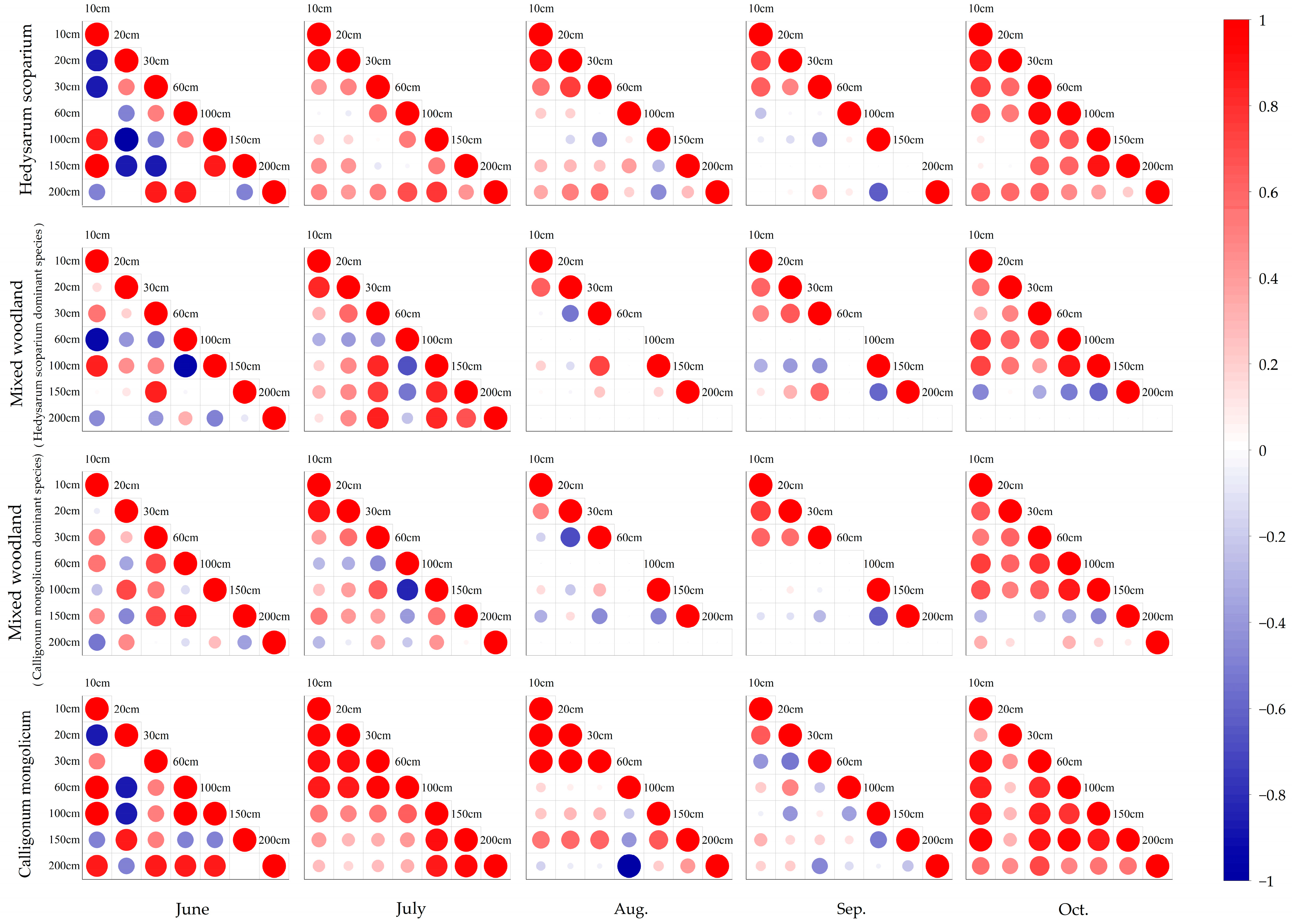
3.3. Spatiotemporal Variability of Soil Moisture

Relevant studies have found that the coefficient of variation (CV) can effectively describe the spatial and temporal variability of the statistical characteristics of soil water content. The smaller the coefficient of variation of soil water content, the more stable the change in soil water content, and the less affected it will be by the environment. In order to better reflect the change law of soil moisture in the study area, Table 4 shows the calculation of the time variation coefficient of soil moisture in four kinds of aerial shrub land. The time variation coefficient of different soil layers in four kinds of aerial shrub land shows that the variation coefficient of soil moisture in four kinds of aerial shrub land is less than 100%, indicating that there is no strong variability in soil moisture content. The temporal variation coefficient of soil moisture in the surface layer (0–30 cm) of the study area is above 10%, indicating that the surface soil water is greatly affected by precipitation, temperature, evaporation and other factors, and the water thus changes drastically. With the increase in soil depth, the temporal variation coefficients of soil water content in four kinds of aerially sown shrublands decreased to varying degrees, indicating that the stability of soil water in the lower layer was stronger than that in the surface layer. The soil water content in the shallow (30–100 cm) and middle (100–150 cm) layers of Hedysarum scoparium forest showed weak variability, and the variation coefficients were 7.81% and 2.73%, respectively. The variation coefficients of soil water content in the shallow (30–100 cm) and middle (100–150 cm) layers of Calligonum mongolicum forest, mixed forest (Hedysarum scoparium dominant species) and mixed forest (Calligonum mongolicum dominant species) were all greater than 10%, showing moderate variability. This phenomenon is related to the root distribution of Hedysarum scoparium and Calligonum mongolicum.
The variability in soil water content in the deep layers (150–200 cm) of the four kinds of aerial seeding shrubs was different. Among them, the maximum was 14.83% in the Calligonum mongolicum forest land, which indicates medium variability, and the minimum was 7.12% in the mixed forest land (Calligonum mongolicum dominant species), indicating weak variability. Under normal circumstances, soil moisture is less affected by precipitation, temperature, evaporation and other factors in the deep layer, and its stability is also the strongest. However, due to the influence of plant roots’ water consumption, there are some differences in soil moisture stability in the deep layers (150–200 cm) of different vegetation types. On the whole, the variation coefficients of soil moisture in each soil layer can be ranked as: Calligonum mongolicum forest land (22.5%) > mixed forest land (Hedysarum scoparium dominant species) (17.16%) > mixed forest land (Calligonum mongolicum dominant species) (16.79%) > Hedysarum scoparium forest land (14.1%).

3.4. Time Stability of Soil Water Content

The Spearman rank correlation coefficient can be used to analyze the temporal stability of the spatial pattern of soil water content. As shown in Figure 5, the Spearman rank correlation coefficients of soil water content in different soil layers of four kinds of aerial shrub land were analyzed. It was found that the soil water contents of the four kinds of aerial shrub land had high correlation coefficients in the surface layer (0–30 cm) and deep layer (150–200 cm), indicating that the spatial pattern of soil water content in the surface layer and deep layer of the study area was stable over time. From June to October, the correlation coefficients of the soil’s surface, middle and deep layers were high (0.438–0.931, −0.395–0.929, −0.457–0.849) and significant at the 0.01 level. The correlation coefficient of soil moisture in mixed forest land (Hedysarum scoparium dominant species) was smaller than that in Hedysarum scoparium forest land, and the correlations of the surface layer, shallow layer and deep layer were significant at the 0.01 level. The correlation coefficients of the soil’s surface and shallow layers in mixed forest land (Calligonum mongolicum dominant species) were higher (0.438–0.931, −0.395–0.929, −0.457–0.849), and were significant at the 0.01 level. The correlations of Calligonum mongolicum forest land at the soil surface, shallow and deep layers were significant. Comparing the Spearman rank correlation coefficient of soil water content from June to October in the growing season, it was found that the correlation coefficients of the four aerial shrub lands in June and October were higher, and the correlation coefficients in August and September were lower. The correlation coefficient in September was the lowest, with an average of 0.317, indicating that the spatial patterns of the surface and deep soil water contents in the growing season of the study area were stable in June and October, while the stability in September was the lowest.

4. Discussion

Soil moisture is the main restricting factor in relation to the growth and restoration of aerial seeding vegetation in the Tengger Desert. The soil moisture content in the growing season is higher. The average soil moisture contents of four kinds of aerial seeding shrubs from June to October were 0.81%, 0.68%, 0.65% and 0.75%, respectively. The variation characteristics of the average soil moisture contents and the corresponding precipitation in the study area show good synchronization on the whole, indicating that precipitation has a strong impact on the change of surface soil moisture content. The shallow layer is relatively less affected by rainfall, and the middle and deep layers are almost not affected by rainfall. Markewitz et al. [31] found that there was a linear relationship between soil water replenishment and rainfall, and the response of rainfall to soil moisture decreased with the increase in soil depth, which was consistent with this study. Chen [32] studied the artificial sand-fixing vegetation area in the loess hilly region. The results show that the soil moisture was mainly supplemented by rainfall in the 0–60 cm soil layer, and the soil moisture below the 100 cm soil layer remained stable, which result is similar to those regarding the low soil moisture content of the four vegetation communities in the 150–200 cm soil layer. Vegetation coverage will lead to inconsistencies between surface soil moisture content and rainfall, but the vegetation coverage in this study area is low, and the aboveground part of the vegetation intercepts rainwater less, so the change in surface soil moisture content is basically consistent with the change in rainfall.
We can infer from the temporal variation coefficient of soil moisture in different aerially sown shrublands that the spatial and temporal variation characteristics of soil moisture are generally moderate, and the soil moisture variability in the surface layer (0–30 cm) is higher. This is because the surface soil moisture is more susceptible to rainfall, infiltration, transpiration, evaporation and human activities [33,34], and the 0–30 cm soil layer soil moisture recharge in this area is also dominated by random and intermittent precipitation. and the 0–30 cm soil layer in this area is also dominated by random and intermittent precipitation. At the same time, the strong evapotranspiration of vegetation is an important channel of soil moisture output. These two factors cause the soil moisture in this layer to oscillate [35]. This finding is similar to the research results of Zhang [36] on the spatial and temporal variability of surface soil moisture in desert landscape in the middle reaches of the Heihe River. The degree of soil moisture variability in the shallow (30–100 cm) and middle (100–150 cm) layers of different aerially sown shrublands is quite different. This is due to the different vegetation compositions, root distributions and water consumptions, resulting in different soil moisture changes in the shallow and middle layers of different shrublands. The variation coefficients of soil moisture in the 150–200 cm soil layers of four kinds of aerial seeding shrub land in the study area are small, mainly because the 150–200 cm soil layer is protected by the upper soil and is less affected by external factors. Therefore, the time variation coefficient of each vegetation type decreases with the increase in soil depth, indicating that the time stability of soil moisture increases with the increase in depth. Chen et al. [37] studied the temporal stability of soil moisture in artificial Robinia pseudoacacia forests with different restoration years in the loess hilly region, and found that the influence of vegetation factors on the temporal stability of soil moisture was also very important. The temporal stability of soil moisture is a result of the interaction of vegetation, topography, climate, soil and many other factors. The dynamics of soil moisture in arid and semi-arid regions are mainly affected by precipitation infiltration, vegetation root absorption and soil evaporation [38,39,40]. Precipitation infiltration is determined by precipitation characteristics and soil characteristics. Plant roots determine the absorption of soil moisture. Soil evaporation is subject to vegetation coverage. The soil layer at about 1 m is less affected by evaporation than the surface layer, and deeper soil layers can be recharged by precipitation infiltration [41]. This soil layer is also where plants’ roots absorb water more actively. Precipitation infiltration recharge can also offset the absorption of vegetation roots to a certain extent [42]. Therefore, soil moisture at this depth shows obvious time stability.
The temporal stability of soil moisture can be analyzed using the Spearman rank correlation coefficient. This study found that the similarity in soil moisture contents in four spatial patterns was weak over time; that is, the spatial pattern of soil moisture content was less stable over time. Most researchers believe that the time stability of soil water content increases with the increase in soil depth and average water content [43]. Cosh et al. [44] studied the temporal stability characteristics of soil moisture content at the surface layer 5 cm, and also drew similar conclusions. Grant et al. [45] studied the 1.2 m soil moisture, and found that the Spearman rank correlation coefficient was more than 0.8, which is consistent with the results of this study. The temporal stability of the spatial distribution of surface soil moisture in the study area was worse than that in the deep layer. Gómez-Plaza [16] discussed the influence of topography, vegetation and other factors on the temporal stability of soil water. The results show that when the factors affecting soil water were limited to geographical location and topography, soil water showed a relatively stable spatial distribution in time. When factors such as vegetation also affect soil water, the spatial distribution structure of soil water becomes unstable. The stability of the spatial and temporal distribution of soil moisture shows that the method of studying spatial and temporal variation is soil moisture is reliable, and also provides a scientific basis for the management of the aerial seeding of plants in the Tengger Desert. Although the only source of soil moisture recharge for aerial seeding plants in desert areas is rainfall, the spatial and temporal stability of soil moisture is also affected by soil texture, topography, sandy vegetation, animals and local human activities. Therefore, the spatial and temporal distribution of soil moisture on a continuous long-term scale needs to be further studied, as do methods to ensure the temporal stability of soil moisture on a large scale and accurately select the appropriate representative sample points. Moreover, the limitation is that the temporal stability of soil moisture is controlled by the mixing of control factors, rather than a single factor. How to analyze the interaction of various factors affecting soil moisture stability is what we should explore in the future.

5. Conclusions

After 30 years of growth and recovery, the spatial and temporal characteristics of soil moisture in the Tengger Desert have changed significantly. The following conclusions are drawn:
(1)
The soil water storage of the four kinds of aerial shrub land reached their highest levels in August, and the average levels of soil water storage during the growing season can be ranked as Calligonum mongolicum forest land (21.34 mm) > Hedysarum scoparium forest land (20.63 mm) > mixed forest land (Hedysarum scoparium dominant species) (19.36 mm) > mixed forest land (Calligonum mongolicum dominant species) (18.88 mm);
(2)
The soil water content in the 0–200 cm layer of different aerial seeding shrub lands changed obviously with time. Among them, the surface soil water content fluctuated most in different months, the range of change in the shallow soil water content was smaller than that in the surface layer, and the fluctuations in the middle (100–150 cm) and deep layer soil water contents were stable;
(3)
There was no strong variability in soil moisture content in the study area. Further, the temporal variation coefficient of the soil moisture at the surface was the highest (31.44~39.8%), and the soil moisture stability was weak. The soil moisture stability of different aerial seeding shrub lands can be ranked as Hedysarum scoparium forest land > mixed forest land (Calligonum mongolicum dominant species) > mixed forest land (Hedysarum scoparium dominant species) > Calligonum mongolicum forest land;
(4)
The soil water contents of the four kinds of aerially sown shrub land showed high correlation coefficients in the surface layer (0–30 cm) and deep layer (150–200 cm), and the time stability of soil water was high. The temporal stability of surface and deep soil moisture during the growing season in the four kinds of aerial shrub land was high in June and October, and the lowest in September.

Author Contributions

Conceptualization, Z.Z. and G.T.; methodology, J.W., Y.L. and Y.G.; validation, G.T. and Z.Z.; writing—original draft preparation, Z.Z.; review and editing, J.W.; supervision, Y.G. and Y.L. All authors have read and agreed to the published version of the manuscript.

Funding

Inner Mongolia Autonomous Region Science and Technology Plan Project (2022YFHH0096); Basic scientific research business fee project of Chinese Academy of Water Sciences (MK0145B022021); 2020 Alashan Left Banner Aerial Seeding Afforestation Science and Technology Support Project (MK0199B012021)

Data Availability Statement

The data are not publicly available due to confidentiality. The data presented in this study are available on request from the corresponding author.

Acknowledgments

The authors are very grateful to all the partners who participated in this study and the research platform provided by the Institute of Water Resources for Pastoral Area Ministry of Water Resources. The authors would like to thank the reviewers for their help and constructive comments and suggestions, which greatly improved the quality of this manuscript.

Conflicts of Interest

The authors declare no conflict of interest.

References

  1. Vachaud, G.A.; Silans, A.P.D.; Balabanis, P.; Vauclin, M. Temporal Stability of Spatially Measured Soil Water Probability Density Function1. Soil Sci. Soc. Am. J. 1985, 49, 822–828. [Google Scholar] [CrossRef]
  2. Chen, H.M.; Shao, M.A.; Li, Y.Y. Soil desiccation in the Loess Plateau of China. Geoderma 2008, 143, 91–100. [Google Scholar] [CrossRef]
  3. Hu, W.; Shao, M.A.; Reichardt, K. Using a New Criterion to Identify Sites for Mean Soil Water Storage Evaluation. Soil Sci. Soc. Am. J. 2010, 74, 762–773. [Google Scholar] [CrossRef]
  4. Heathman, G.C.; Cosh, M.H.; Merwade, V.; Han, E.J. Multi-scale temporal stability analysis of surface and subsurface soil moisture within the Upper Cedar Creek Watershed, Indiana. Catena 2012, 95, 91–103. [Google Scholar] [CrossRef]
  5. Wang, G.H.; Chen, Z.X.; Shen, Y.Y.; Yang, X.L. Efficient prediction of profile mean soil water content for hillslope-scale Caragana korshinskii plantation using temporal stability analysis. Catena 2021, 206, 105491. [Google Scholar] [CrossRef]
  6. Liu, Z.B.; Wang, Y.H.; Yu, P.T.; Tian, A.; Wang, Y.R.; Xiong, W.; Xu, L.H. Spatial Pattern and Temporal Stability of Root-Zone Soil Moisture during Growing Season on a Larch Plantation Hillslope in Northwest China. Forests 2018, 9, 68. [Google Scholar] [CrossRef]
  7. Gao, L.; Shao, M.A.; Peng, X.H.; She, D.L. Spatio-temporal variability and temporal stability of water contents distributed within soil profiles at a hillslope scale. Catena 2015, 132, 29–36. [Google Scholar] [CrossRef]
  8. Ibrahim, H.M.; Huggins, D.R. Spatio-temporal patterns of soil water storage under dryland agriculture at the watershed scale. J. Hydrol. (Amst.) 2011, 404, 186–197. [Google Scholar] [CrossRef]
  9. Zhu, X.; He, Z.B.; Du, J.; Chen, L.F.; Lin, P.F.; Tian, Q.Y. Soil moisture temporal stability and spatio-temporal variability about a typical subalpine ecosystem in northwestern China. Hydrol. Process. 2020, 34, 2401–2417. [Google Scholar] [CrossRef]
  10. He, Z.B.; Zhao, M.M.; Zhu, X.; Du, J.; Chen, F.L.; Lin, P.F.; Li, J. Temporal stability of soil water storage in multiple soil layers in high-elevation forests. J. Hydrol. (Amst.) 2019, 569, 532–545. [Google Scholar] [CrossRef]
  11. Comegna, V.; Basile, A. Temporal stability of spatial patterns of soil water storage in a cultivated Vesuvian soil. Geoderma 1994, 62, 299–310. [Google Scholar] [CrossRef]
  12. Penna, D.; Brocca, L.; Borga, M.; Fontana, G.D. Soil moisture temporal stability at different depths on two alpine hillslopes during wet and dry periods. J. Hydrol. (Amst.) 2013, 477, 55–71. [Google Scholar] [CrossRef]
  13. Zhao, Z.M.; Shen, Y.X.; Wang, Q.H.; Jiang, R.H. The temporal stability of soil moisture spatial pattern and its influencing factors in rocky environments. Catena 2020, 187, 104418. [Google Scholar] [CrossRef]
  14. Wang, Y.Q.; Hu, W.; Zhu, Y.J.; Shao, M.A.; Xiao, S.; Zhang, C.C. Vertical distribution and temporal stability of soil water in 21-m profiles under different land uses on the Loess Plateau in China. J. Hydrol. (Amst.) 2015, 527, 543–554. [Google Scholar] [CrossRef]
  15. Gao, L.; Shao, M.A. Temporal stability of soil water storage in diverse soil layers. Catena 2012, 95, 24–32. [Google Scholar] [CrossRef]
  16. Gómez-Plaza, A.; Alvarez-Rogel, J.; Albaladejo, J.; Castillo, V.M. Spatial patterns and temporal stability of soil moisture across a range of scales in a semi-arid environment. Hydrol. Process. 2000, 14, 1261–1277. [Google Scholar] [CrossRef]
  17. Cho, E.; Choi, M. Regional scale spatiotemporal variability of soil moisture and its relationship with meteorological factors over the Korean peninsula. J. Hydrol. (Amst.) 2014, 516, 317–329. [Google Scholar] [CrossRef]
  18. Gbohoui, Y.P.; Paturel, J.; Tazen, F.; Mounirou, L.A.; Yonaba, R.; Karambiri, H.; Yacouba, H. Impacts of climate and environmental changes on water resources: A multi-scale study based on Nakanb’e nested watersheds in West African Sahel. J. Hydrol. Reg. Stud. 2021, 35, 100828. [Google Scholar] [CrossRef]
  19. Muratoglu, A.; Iraz, E.; Ercin, E. Water resources management of large hydrological basins in semi-arid regions: Spatial and temporal variability of water footprint of the Upper Euphrates River basin. Sci. Total Environ. 2022, 846, 153796. [Google Scholar] [CrossRef]
  20. Saeed, F.H.; Al-Khafaji, M.S.; Al-Faraj, F. Hydrologic response of arid and semi-arid river basins in Iraq under a changing climate. J. Water Clim. Chang. 2022, 13, 1225–1240. [Google Scholar] [CrossRef]
  21. Del Jesus, M.; Rinaldo, A.; Rodriguez-Iturbe, I. Point rainfall statistics for ecohydrological analyses derived from satellite integrated rainfall measurements. Water Resour. Res. 2015, 51, 2974–2985. [Google Scholar] [CrossRef]
  22. Priyadarshini, K.V.; Prins, H.H.; de Bie, S.; Heitkönig, I.M.; Woodborne, S.; Gort, G.; Kirkman, K.; Ludwig, F.; Dawson, T.E.; de Kroon, H. Seasonality of hydraulic redistribution by trees to grasses and changes in their water-source use that change tree-grass interactions. Ecohydrology 2016, 9, 218–228. [Google Scholar] [CrossRef]
  23. Amy, A.; McCole; Libby, A.S. Seasonal water use patterns of Juniperus ashei on the Edwards Plateau, Texas, based on stable isotopes in water. J. Hydrol. (Amst.) 2007, 342, 238–248. [Google Scholar] [CrossRef]
  24. Wu, H.W.; Li, X.Y.; Jiang, Z.Y.; Chen, H.Y.; Zhang, C.C.; Xiao, L. Contrasting water use pattern of introduced and native plants in an alpine desert ecosystem, Northeast Qinghai–Tibet Plateau, China. Sci. Total Environ. 2016, 542, 182–191. [Google Scholar] [CrossRef]
  25. Kafando, M.B.; Koïta, M.; Mathieu, L.C.; Yonaba, O.R.; Fowe, T.; Zouré, C.O.; Faye, M.D.; Leye, B. Use of Multidisciplinary Approaches for Groundwater Recharge Mechanism Characterization in Basement Aquifers: Case of Sanon Experimental Catchment in Burkina Faso. Water 2021, 13, 3216. [Google Scholar] [CrossRef]
  26. Tian, Y.J.; Si, J.H.; Cheng, Y.S.; Pang, D.S.; Xie, Z.C. Study on the experiment of aerial sowing afforestation in sandy area of Alxa. J. Arid Land Resour Environ. 2010, 24, 149–153. (In Chinese) [Google Scholar] [CrossRef]
  27. Zhao, C.G.; Li, H.Y.; Yu, T.F.; Chen, W.Y.; Xie, Z.C. Effects of artificial vegetation construction on soil physical properties in the northeastern edge of Tengger Desert. Arid Zone Res. 2022, 39, 1112–1121. (In Chinese) [Google Scholar] [CrossRef]
  28. Yang, T.T.; Musa, A.; Zhang, Y.S.; Wu, J.B.; Wang, A.Z.; Guan, D.X. Characteristics of soil moisture under different vegetation coverage in Horqin Sandy Land, northern China. PLoS ONE 2018, 13, e0198805. [Google Scholar] [CrossRef]
  29. Han, X.Y.; Liu, W.Z.; Cheng, L.P. Vertical distribution characteristics and temporal stability of soil water in deep profile on the Loess TablelanoNorthwest China. Chin. J. Appl. Ecol. 2017, 28, 430–438. (In Chinese) [Google Scholar] [CrossRef]
  30. Shan, Y.L.; Xie, J.C.; Han, Q.C.; Lei, N.; Dong, Q.G. Soil moisture characteristics and temporal stability on the slope of the Loess Plateau: A case study of Jjiulongquan ditch in Yan’an city. J. Soil Water Conserv. 2021, 19, 1–7. (In Chinese) [Google Scholar] [CrossRef]
  31. Markewitz, D.; Devine, S.; Davidson, E.A.; Brando, P.; Nepstad, D.C. Soil moisture depletion under simulated drought in the Amazon: Impacts on deep root uptake. New Phytol. 2010, 187, 592–607. [Google Scholar] [CrossRef] [PubMed]
  32. Chen, W.L.; Li, Z.S.; Jiao, L.; Wang, C.; Gao, G.Y.; Fu, B.J. Response of Soil Moisture to Rainfall Event in Black Locust Plantations at Different Stages of Restoration in Hilly-gully Area of the Loess Plateau, China. Chin. Geogr. Sci. 2020, 30, 19. [Google Scholar] [CrossRef]
  33. Seneviratne, S.I.; Corti, T.; Davin, E.L.; Hirschi, M.; Jaeger, E.B.; Lehner, I.; Orlowsky, B.; Teuling, A.J. Investigating soil moisture–climate interactions in a changing climate: A review. Earth-Sci. Rev. 2010, 99, 125–161. [Google Scholar] [CrossRef]
  34. Gao, L.; Shao, M.A. Temporal stability of shallow soil water content for three adjacent transects on a hillslope. Agric. Water Manag. 2012, 110, 41–54. [Google Scholar] [CrossRef]
  35. Zhao, X.; Zhu, C.; Zheng, Y.Z.; Li, T.T.; Yu, N. Temporal stability of soil moisture of Amygdalus pedunculate woodland in Mu Us sandy land. Sci. Soil Water Conserv. 2021, 19, 8–17. [Google Scholar] [CrossRef]
  36. Zhang, P.P. Soil Organic Carbon, Water Variability and Plant Diversity in Desert Landscape in the Middle Reaches of Heihe River Basin. Ph.D. Thesis, Northwest Agriculture and Forestry University, Yang Ling, China, 2014. [Google Scholar]
  37. Chen, W.L.; Wang, S.X.; Qi, T.X.; Jiao, L.; Wang, C.; Maierdang, K.; Li, Z.S.; Fu, B.J. Spatiotemporal dynamics and temporal stability of soil moisture at black locust plantations with different restoration years on hilly region of the loess plateau, China. Acta Ecol. Sin. 2021, 41, 5643–5657. [Google Scholar] [CrossRef]
  38. Zhang, P.; Xiao, P.Q.; Yao, W.Y.; Liu, G.B.; Sun, W.Y. Profile distribution of soil moisture response to precipitation on the Pisha sandstone hillslopes of China. Sci. Rep. 2020, 10, 9136. [Google Scholar] [CrossRef]
  39. Brandt, A.C.; Zhang, Q.; Caceres, M.L.L.; Hideki, M. Soil temperature and soil moisture dynamics in winter and spring under heavy snowfall conditions in North-Eastern Japan. Hydrol. Process. 2020, 34, 3235–3251. [Google Scholar] [CrossRef]
  40. Tian, J.; Zhang, B.Q.; He, C.S.; Han, Z.B.; Bogena, H.R.; Huisman, J.A. Dynamic response patterns of profile soil moisture wetting events under different land covers in the Mountainous area of the Heihe River Watershed, Northwest China. Agric. For. Meteorol. 2019, 271, 225–239. [Google Scholar] [CrossRef]
  41. Zhang, C.C.; Wang, Y.Q.; Jia, X.Y.; Shao, M.A.; An, Z.S. Variations in capacity and storage of plant-available water in deep profiles along a revegetation and precipitation gradient. J. Hydrol. (Amst.) 2020, 581, 124401. [Google Scholar] [CrossRef]
  42. Wang, J.; Fu, B.J.; Wang, L.X.; Lu, N.; Li, J.Y. Water use characteristics of the common tree species in different plantation types in the Loess Plateau of China. Agric. For. Meteorol. 2020, 288–289, 108020. [Google Scholar] [CrossRef]
  43. Xu, G.C.; Ren, Z.P.; Li, P.; Li, Z.B.; Yuan, S.L.; Zhang, H.; Wang, D.; Zhang, Z.Y. Temporal persistence and stability of soil water storage after rainfall on terrace land. Environ. Earth Sci. 2016, 75, 966. [Google Scholar] [CrossRef]
  44. Cosh, M.H.; Jackson, T.J.; Moran, S.; Bindlish, R. Temporal persistence and stability of surface soil moisture in a semi-arid watershed. Remote Sens. Environ. 2008, 112, 304–313. [Google Scholar] [CrossRef]
  45. Grant, L.; Seyfried, M.; McNamara, J. Spatial variation and temporal stability of soil water in a snow-dominated, mountain catchment. Hydrol. Process. 2004, 18, 3493–3511. [Google Scholar] [CrossRef]
Figure 1. Aerial seeding area in 1992.
Water 15 03562 g001
Figure 2. Geographical location of the study area and layout of survey plots.
Water 15 03562 g002
Figure 3. Changes of soil water storage in different aerially sown shrublands during the growing season.
Water 15 03562 g003
Figure 4. Spatial and temporal distribution of soil water content in different shrub lands. (a) Soil water content of Hedysarum scoparium sample plot; (b) soil water content of mixed forest land (Hedysarum scoparium dominant species); (c) soil moisture content of mixed forest land (Calligonum mongolicum dominant species); (d) soil moisture content of Calligonum mongolicum plot.
Water 15 03562 g004
Figure 5. Spearman rank correlation coefficient of soil water content in different soil layers of four kinds of aerial shrub land.
Water 15 03562 g005
Table 1. Basic information of test plots.
PlotSpecies CompositionPlant Height/cmTree Crown/cmBasal Diameter/cmHerbAltitude/mGradientSlope Aspect
IHedysarum scoparium100%176 ± 35179 ± 441.4 ± 0.8Bassia dasyphylla;
Stipa capillata;
Agriophyllum squarrosum
1254 ± 214 ± 1Northwest–Southeast
IICalligonum mongolicum9% + Hedysarum scoparium91%153 ± 51152 ± 422.5 ± 1.3Stipa capillata;
Bassia dasyphylla
1256 ± 211 ± 3Northwest–Southeast
IIIHedysarum scoparium25% + Calligonum mongolicum75%105 ± 28111 ± 301.4 ± 0.8Stipa capillata;
Agriophyllum squarrosum
1268 ± 212 ± 6Northwest–Southeast
IVCalligonum mongolicum100%104 ± 51111 ± 522.0 ± 1.6Allium mongolicum;
Artemisia ordosica Krasch
1273 ± 315 ± 2Northwest–Southeast
Table 2. Soil characteristics of different plant communities.
Soil Characteristics/Plot TypeHedysarum scopariumMixed Woodland
(Hedysarum scoparium Dominant Species)
Mixed Woodland
(Calligonum mongolicum Dominant Species)
Calligonum mongolicum
Crusts coverage (%)39 ± 9 ab 151 ± 18 a51 ± 17 a35 ± 12 b
Soil bulk density (g/cm3)1.45 ± 0.11 b1.50 ± 0.12 a1.46 ± 0.07 b1.46 ± 0.12 b
Soil porosity (%)45.27 ± 3.98 a43.37 ± 4.44 b44.77 ± 2.77 a45.05 ± 4.63 a
1 Lowercase letters indicate significant differences in soil characteristics of different plant communities (p < 0.05).
Table 3. Monitoring data of meteorological stations from June to October 2022.
MonthPrecipitation (mm)Average Temperature (°C)Average Wind Speed (m/s)
June8.7015.342.81
July77.0026.042.03
August170.0022.851.61
September24.3319.211.67
October7.678.871.28
Table 4. Spatial statistical characteristics of mean value, standard deviation and coefficient of variation of soil moisture content in different layers.
Plot TypeSoil DepthSoil Water Content
Average Value
Soil Water Content
Maximum Value
Soil Water Content
Minimum Value
Standard DeviationCoefficient of Variation
Hedysarum scoparium0~30 cm0.88701.28410.54110.294133.16%
30~100 cm0.75020.81810.66700.05867.81%
100~150 cm0.76020.78830.73380.02072.73%
150~200 cm0.79820.92530.69360.101212.68%
Mixed woodland (Hedysarum scoparium dominant species)0~30 cm0.72281.05320.46780.243533.69%
30~100 cm0.64550.75950.50030.094814.68%
100~150 cm0.64310.75350.54550.075111.68%
150~200 cm0.66360.71000.60740.04737.12%
Mixed woodland (Calligonum mongolicum dominant species)0~30 cm0.70111.01790.48570.220431.44%
30~100 cm0.63400.74010.54500.070911.18%
100~150 cm0.63680.80490.55890.099115.56%
150~200 cm0.58070.65820.49630.060810.47%
Calligonum mongolicum0~30 cm0.77141.25610.49110.307039.80%
30~100 cm0.75930.97470.58560.142118.72%
100~150 cm0.75520.89350.60550.125816.65%
150~200 cm0.72140.81600.54320.107014.83%
Disclaimer/Publisher’s Note: The statements, opinions and data contained in all publications are solely those of the individual author(s) and contributor(s) and not of MDPI and/or the editor(s). MDPI and/or the editor(s) disclaim responsibility for any injury to people or property resulting from any ideas, methods, instructions or products referred to in the content.

