Article

The Water Flow Regime in the Weir Area for Vascular and Rush Plant Species Composition

1
Department of Hydrotechnics, Technology and Management, Institute of Civil Engineering, Warsaw University of Life Sciences—SGGW, Nowoursynowska Street, 166, 02-787 Warsaw, Poland
2
Instytut Techniki Budowlanej, Filtrowa Street 1, 00-611 Warsaw, Poland
3
Department of Environmental Protection and Dendrology, Institute of Horticultural Sciences, Warsaw University of Life Sciences—SGGW, Nowoursynowska Street 159, 02-776 Warsaw, Poland
4
Department of Biometry, Institute of Agriculture, Warsaw University of Life Sciences—SGGW, 02-787 Warsaw, Poland
5
Faculty of Civil and Environmental Engineering, Warsaw University of Life Sciences—SGGW, 02-787 Warsaw, Poland
*
Author to whom correspondence should be addressed.
Water 2023, 15(18), 3189; https://doi.org/10.3390/w15183189
Submission received: 18 May 2023 / Revised: 28 August 2023 / Accepted: 4 September 2023 / Published: 7 September 2023
(This article belongs to the Section Water Erosion and Sediment Transport)

Abstract

:
The hydrotechnical construction, damming up the riverbed, creates two zones of hydraulic conditions, which affect the water discharge and sediment transport routes, as well as plant species composition, as a habitat answer to the hydraulic regime. This study examined the diversity of the vascular and rush plant species upstream and downstream of the weir. The Świder River, a small lowland river in Central Poland, was chosen as a study area. An examined river reach was located at 21 + 340 kilometers of the Świder River. Vegetation properties, plant species, and granulometric fraction composition were recognized at chosen cross-sections along the riverbed where specific hydraulic conditions could be met. The spatial distribution of vortices, smooth or rapid flow areas, and velocity pulsations influence the biotic environment, thereby affecting the species composition, quantity, and plant diversity. In the headwater zone, an environment more favorable to grain accumulation could be met, which was mixed with organic components in an agricultural catchment area. This phenomenon leads to creating favorable conditions for increased biodiversity. The present study demonstrated that small weirs could positively affect the composition of vascular and rush plants.

1. Introduction

The water and rush plant species diversity depend on many abiotic factors, i.e., the water reservoir depth, water movement, lighting—sun exposure, semishaded or shaded positions, origins of a given reservoir, as well as anthropogenic influences. The flora could be intentionally introduced as an engineering intervention, as well as as a result of the water fertility degree.
Hydrotechnical structure occurrence could also influence the plant species distribution within the river reach [1,2]. Weir construction can change proper habitat quality and the space for water and rush plants [3,4,5]. The damming of flowing waters significantly affects the water’s chemical, biochemical, and biological processes. In the case of polluted waters, damming the river can cause further deterioration of the water quality [5]. Although the environmental impact of large retention dams is well recognized in the literature, there is still insufficient knowledge regarding small hydraulic structures’ ecological influence [6] on the habitat.
By damming the riverbed, the hydraulic structure causes the formation of two zones of hydraulic conditions. Upstream of the structure, the velocity of the water decreases (A in Figure 1a) due to the water surface rising. This results in sedimentation and the accumulation of transported grains. At the same time, the stream has a smooth and uniform character [7,8,9]. A significant change in the flow’s nature to rapid and fast-changing (B in Figure 1a) could be met at the overflow. A hydraulic jump is formed (C in Figure 1a), where the stream’s internal energy is increased due to significant dispersive processes. Specific hydraulic features downstream of the weir, such as increased turbulence and increased flow velocities within the bed region, result in riverbed erosion processes (E in Figure 1a). The turbulence intensity is generated by stream–solid interactions, which are described by such parameters as the Manning’s roughness coefficient, which is derived from the bedload granulation, riverbed formations, and vegetation presence. The bottom material consists primarily of sand, dust or peat, and loose granular materials that are susceptible to erosion. The excessive, uncontrolled development of local erosive processes in the form of local scouring can threaten the damming structure’s stability. The stream velocity in the cross-section is equalized at a certain distance from the structure (D in Figure 1a).
Due to the interaction between the higher stream velocity in the main channel and the lower velocity in the riparian region, especially in compound channels, the high complexity of hydraulic processes can be observed (Figure 1b). This results in the formation of a vertically oriented shear layer stresses at the interface between the main channel and the floodplain [10,11]. This produces strong vortices with vertical axes.
The dammed water at the headwater of the weir is characterized by a reduced flow velocity compared to conditions in the undeveloped channel. This results in the occurrence of suspended load sedimentation and bedload accumulation. To prevent excessive sediment deposition, flushing drains or channels should be used (Figure 2).
Remarkably limited research has been conducted on the mechanical properties of aquatic plants, particularly when compared to the extensive body of literature available on seaweeds [12]. Aquatic plants are exposed to hydrostatic pressure, as well as hydrodynamic pressure. Bernoulli’s law, which is derived from the principle of the conservation of energy, can be written as follows for flowing rivers:
ρ g h h y d r o s t a t i c   p r e s s u r e + 1 2 ρ v 2 h y d r o d y n a m i c   p r e s s u r e + p a t m o s p h e r i c   p r e s s u r e   = c o n s t
where ρ is the fluid density [kg m−3]; g is the gravity acceleration [m s−2]; h is the water depth [m]; and v is the stream velocity [m s−1]. A water plant that is connected to the riverbed is subjected to hydrodynamic forces in the weir region. The total force applied to the various components of the plant can be described as the vector sum of two forces that act orthogonally and in opposite directions. The first force is the lift force, which acts perpendicular to the flow direction, and the second force consists of two horizontal components: the pressure force and the acceleration force (see Figure 3).
Most submerged plant species cope with these forces by easily bending, thus reducing resistance. Bending enables plants to absorb large amounts of energy without breaking. The longitudinal elasticity in plants could be described using the Young’s modulus, which is a hypothetical stress that would occur when the sample material is stretched to twice its length, assuming no change in its cross-section. However, such studies are primarily conducted in the field of materials engineering, and comprehensive research on plants, especially those growing on the edges and bottoms of channels, is lacking. Submerged and emergent aquatic plants often have a fairly flexible structure and resist the forces acting upon them through various strategies [13,14]. Fully submerged plants have a simplified structure, while some emergent plants possess specifically twisted stem structures that allow for strong bending without buckling.
The stream flowing out of the narrower channel gradually widens and, at some distance, covers the entire cross-section (A in Figure 4a). Therefore, areas of stream detachment and associated return flow areas (recirculation zones) appear (B in Figure 4a). Since the kinetic energy of the return flows is taken from the energy of the mainstream, such flows are associated with significant energy losses. In situ observations [15,16] and laboratory tests [17] have demonstrated that the major influences on the banks and floodplain erosion caused by coastal Kármán vortices with a vertical axis of rotation are the weir and bank connection manners. A parallel stream movement can be observed in weirs with vertical abutments or in conditions where only the centrally located slot is open (A in Figure 4b). They only detach from the sidewalls in the final part of an abutment, wherein they head towards the channel center. Simultaneously, those streams cause large vertical axis eddie formations (B in Figure 4b), which are located at the bank slopes within the unprotected area. A stream velocity concentration can also be observed in the river bed’s central region (C in Figure 4b).
Determining the total discharge for a given cross-section requires dividing the cross-section into smaller areas for which a constant velocity distribution can be assumed. As a basis for defining the boundaries of the subareas is the distribution of the channel roughness coefficient n. For each of the subareas, the flow rate is calculated according to the following form of the Manning’s equation (Equations (2) and (3)):
Q w = K · S f 1 / 2
K = 1 n A R h 2 / 3
where K is the cross-sectional conveyance module, expressing the flow rate at unit inclinations, and A is the flow area. The total flow coefficient is obtained by summing the values calculated for the left and right bank, as well as the main channel (Figure 5). If the roughness of the main channel is constant, then it is not necessary to divide it into smaller areas when calculating the conveyance module. If more than one value of the roughness coefficient n is present within a computational cross-section, an equivalent roughness coefficient nc is calculated. To determine its value, the main flow area is divided into N suareas with known values of the wetted perimeter Pi and the roughness coefficient ni. It can then be calculated according to the following formula:
n c = [ i = 1 N ( P i n i 3 / 2 ) P ] 2 / 3
where P is the whole flow area wetted perimeter.
The effect of the vegetation structure on the Manning coefficient is complex and depends on many factors, such as the plant species, their density, the layout of the river cross-section, and the variability in hydraulic conditions. The vegetation in rivers can affect the Manning coefficient by, among other things, lowering the flow velocity, creating local turbulence and backwater zones, changing the bed and the medium shear stress, or even creating conditions that are favorable for water retention.
Dense vegetation on the river bed and banks can inhibit the velocity of the water flow, thereby leading to increased resistance. The Manning coefficient is lower for slower-flowing velocities, so the presence of vegetation can result in an increase in its value. In addition, vegetation on the banks and bottom of the river can change the shape of the cross-section by creating obstacles to the water flow. These changes can affect the value of the Manning coefficient, especially if the flow depth and cross-sectional area change. The presence of vegetation on the river bottom can affect the friction between the water and the bottom. Some types of vegetation can change the frictional properties at the surface, which affects the value of the Manning coefficient.
River vegetation can be determined by the interactions of physical factors: water flow characteristics. They govern plant morphology, prevail over the growth-controlling factors, and influence the habitat. Therefore, turbulent flows will determine the presence or absence of instream vegetation and dominate even light access to the giver reach [18,19]. Considering the alluvial character of lowland rivers, decreased stream velocities are associated with a Nupharo–Nymphaeetum complex in Central European conditions. The flowing water vegetation is also represented by plant species whose organs, i.e., leaves, stems, and flowers, are completely submerged. These include, among others, Ceratophyllumdemersum, Elodea canadensis, and Potamogetonlucens [20].
The vegetation in rivers performs an essential role in shaping sediment transport. This influence is driven by a variety of mechanisms that plants use to affect water flow and granular particle transport. Aquatic plants can change the structure of the water flow, thus affecting the distribution of the velocities and stream directions. These alterations lead to the formation of low velocity zones, where most of the bed material transported by the river is deposited. Vegetation can also create barriers that impede the flow and cause particles sedimentation.
The roots of aquatic plants attach to granular particles, which affect their stability and durability. Plants form specific retention structures that are capable of retaining and collecting the material carried by water. Additionally, roots attached to river banks can maintain stability and reduce bank erosion.
Vegetation affects the sediment transport o by reducing the flow of energy. Plants inhibit the water velocity, thereby leading to the deposition of carried material. The increased resistance caused by vegetation also results in higher shear forces, which can result in bank erosion and changes in the riverbed.
The vegetation in rivers can reduce the velocity of the sediment transport, promote deposition, and stabilize the banks and riverbed. However, the effects of the vegetation on the sediment transport depend on many factors, such as the type of plants, their density and spatial arrangement, as well as the hydromorphological characteristics of a particular river environment.
Rushes are aquatic plants that thrive in the wetland habitats of both naturally formed bodies of water and artificially constructed water reservoirs. The vegetation zoning can especially be distinguished in reservoirs with stagnant water, i.e., lakeshores in oxbow lakes, where the side stream velocity is insignificant (Figure 6). Large-sized rushes are exemplified by Iridetumpseudoacori or Phalaridetumarundinaceae, among others. Iridetumpseudoacori, which comprises ornamental plant species with distinctive habits and flowers, such as Iris pseudoacorus, Rumexhydrolapathum, and Stellaria palustris, is a notable example.
Floodplains are often overgrown with rush communities, which are represented by Phragmitetumautralisand Typhetumangustifoliae, among others. Phragmitetumautralis prefers positions with stagnant and slow-flowing water, and its species composition includes, among others, Phragmitesaustralis, Typhalatifolia, and Rumexhydrolapathum. Another rush community that is mainly associated with stagnant water is Typhetumangustifoliae. The botanical assemblages are comprised of various plant species, including Typhaangustifolia, Phragmitesaustralis, and Rumexhydrolapathum. Communities representing the rush vegetation can be represented by Sparganietumerecti, which includes a unique plant, Sparganiumerectum, within its composition, which is characterized by very decorative flowers. The admixture also contains other plant species related to the aquatic environment, such as Phragmitesaustralis or Carexgracilis [20].
The overgrowth of moist areas with lichens and mosses could also be present on the abutment’s surface, where cracks and cavities are present. Various physicochemical reactions can be observed on hydrotechnical structures, including metal corrosion (the rusting of steel structures), scaling (the deposition of mineral salts on the structures’ surfaces), changes in the water pH, water pollution (by leaks of oil, fuel, or chemicals), chemical reactions between the structures’ materials and the water, the dissolution of building materials in the water (e.g., in the case of some types of mortars and plasters), and siltation. Such phenomena are factors that differentiate the biota on hydrotechnical structure elements [21].
This investigation aimed to discern the variances in both the aquatic and the rush communities situated upstream and downstream of a weir positioned in the Świder River in the central region of Poland. The formulated research hypotheses were distinguished as follows:
Hypothesis 1.
Changes in hydraulic stream characteristics can be observed within the riverbanks and the bed zone, both upstream and downstream of the weir, as a direct influence of the damming structure. In the biotic environment, these changes will affect the species composition, quantity, and species diversity of plants.
Hypothesis 2.
An environment more favorable to vegetation and increased biodiversity appears in the upstream zone.
Hypothesis 3.
The upper stand will be characterized by the presence of species that require more stable conditions: this includes a low variability in the water levels and slower stream velocities; meanwhile, due to hydraulic conditions downstream, species that are prone to rapid flows can be met.

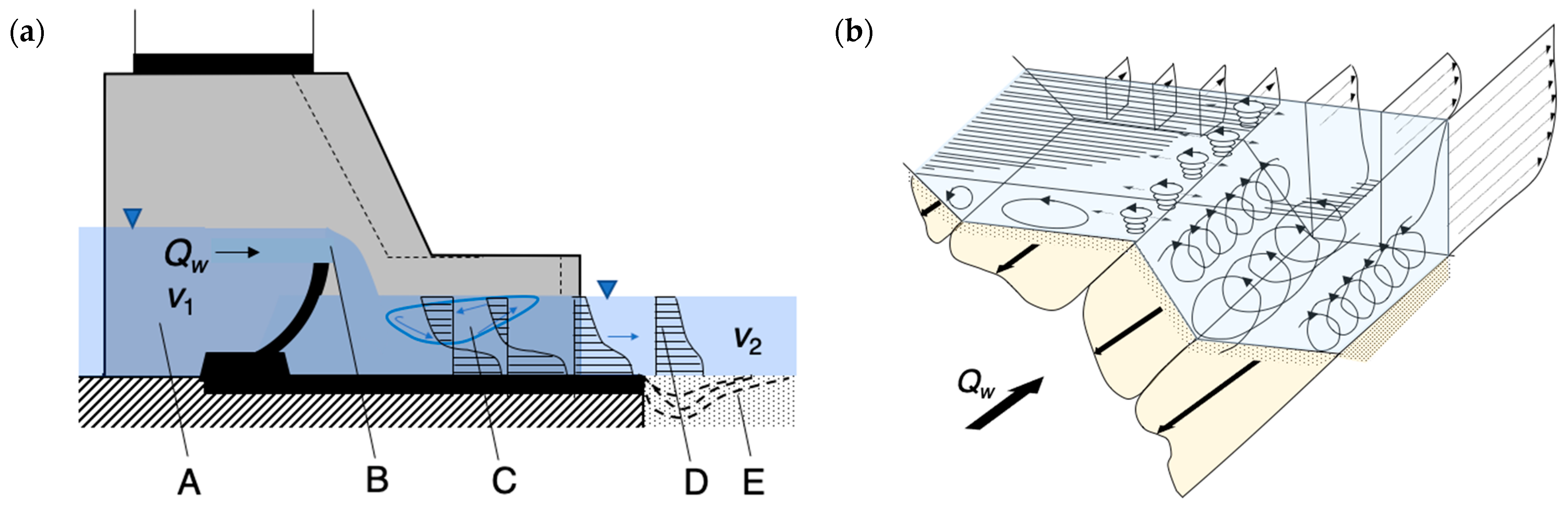
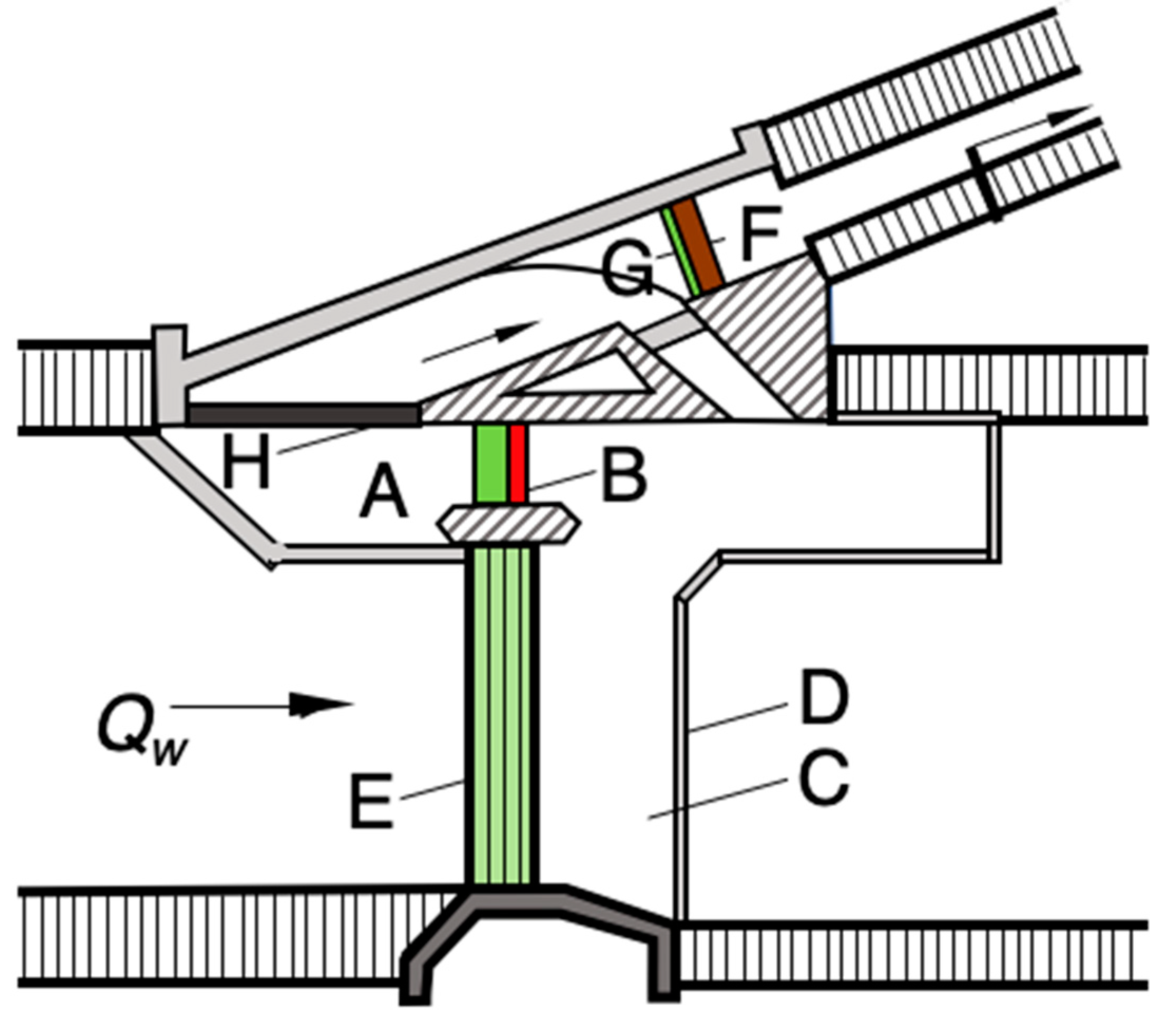
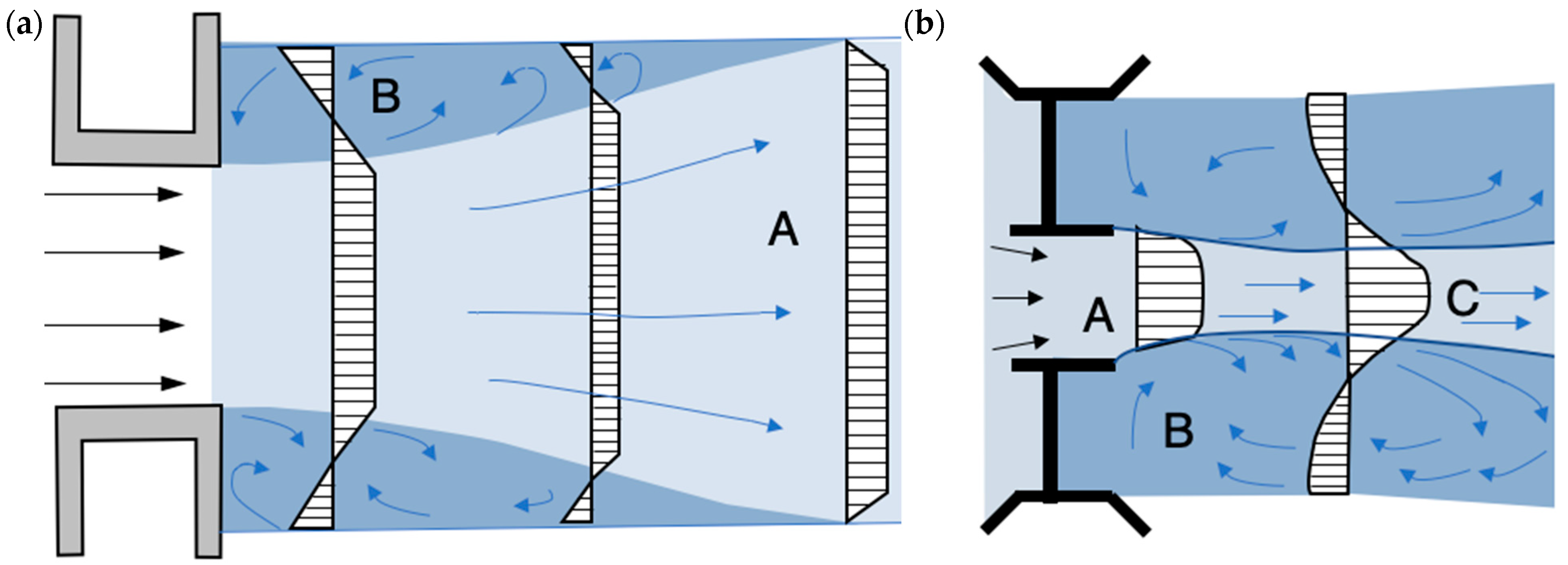
2. Materials and Methods
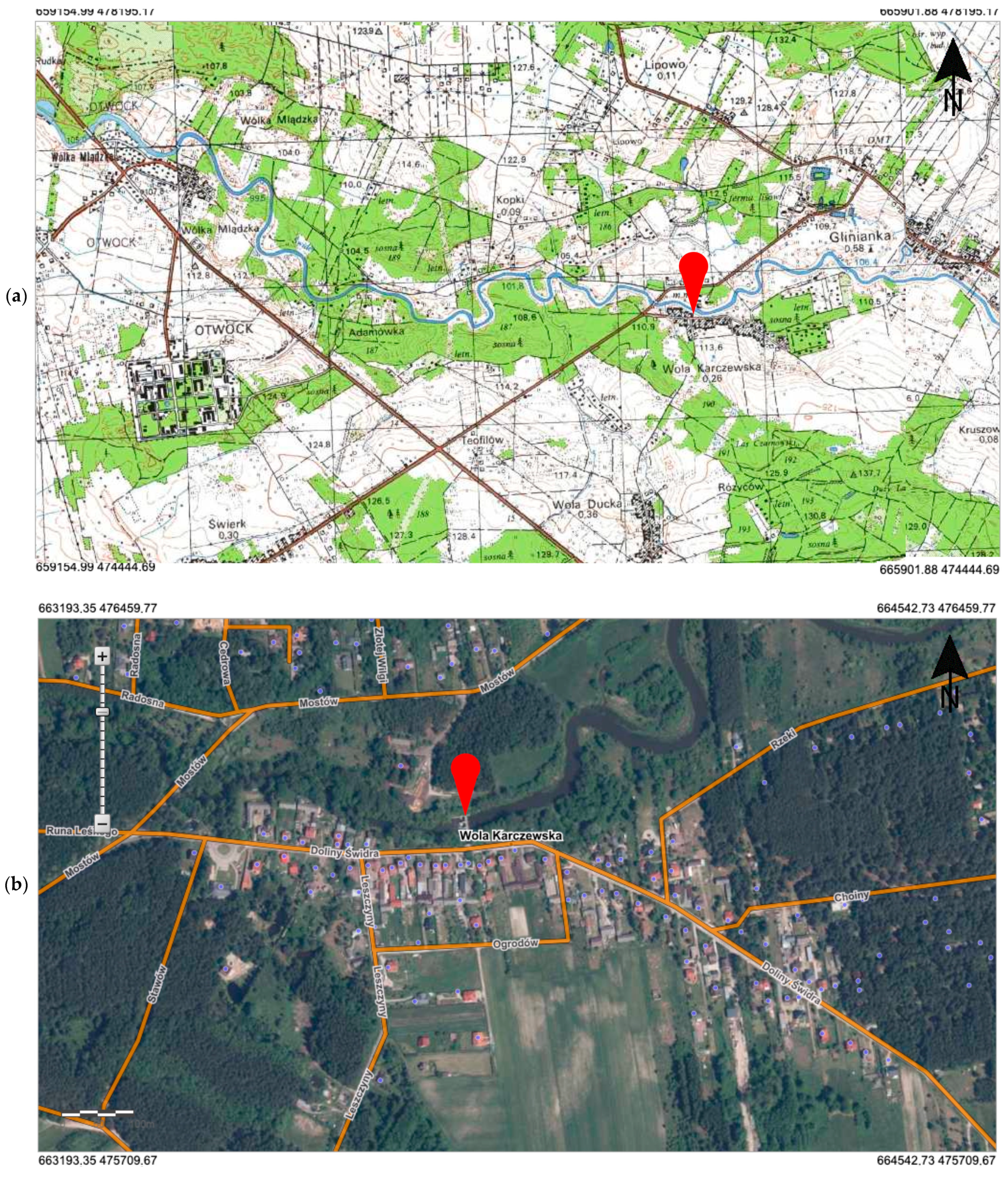
Study Area

The research site is situated both upstream and downstream of a concrete weir located at 21 + 340 km of the Świder River in the village of Wola Karczewska, which belongs to the Wiązowna commune and is located about 30 km away from the city center of Warsaw in Poland (Figure 7a,b). The main focus of the study was the concrete weir, which was constructed on the site of an old mill (as shown in Figure 8). As the mill was closed, and an old weir was out of service and not maintained, its machinery and construction became completely destroyed. Consequently, there was strong bed erosion at a significant river reach, thus leading to the groundwater level decrease. Wells in the WolaKarczewska village began to dry up. As a result of adjacent soil drying up, the soil’s suitability for agricultural purposes lost its properties, and trees along the river decayed. These undesirable changes led to the decision to pursue reconstruction efforts. The new weir construction, made of reinforced concrete, was carried out in order to accomplish the following:
-
The inhibition of the progressive bed erosion;
-
Prevent groundwater raising in the adjacent area;
-
Promote agricultural land irrigation on an area of about 150 ha;
-
For recreational purposes.
The weir was made as a monolithic reinforced concrete dock structure with a concrete compressive strength class of B15 (not less than 17 MPa), a watertight class of W4, and a frost resistance class of M100 according to Polish national standard [22]. The structure is classified as a class IV building according to Eurocode 2 [23]. The total weir passage is 21 m wide and is divided by two pillars into three 7 m passages with flap closures. The facility was put into service at the end of the 1990s. It has been used for about 25 years, and there are visible signs of exploitation and corrosion. Visible cracks and salt infiltration indicate the occurrence of alkali–aggregate corrosion, which is a frequent phenomenon occurring in this type of object and which sometimes leads to very serious failures [24].
The riverbed of the Świder River comprises a 20 m wide strip of banks that belongs to the “Świder” Landscape Reserve. The remaining land, within the impact of the backwater, is mainly covered with grasses and farm buildings, as well as by dense trees, especially on the right bank [25]. The impact of the weir on the crops was analyzed before building the construction; however, its influence on the wild plants and their biodiversity has not been discovered, which underlies the novelty of this paper.
The current scientific approach assumed 80 study plot distinctions on riverbanks downstream (A1, A2) and upstream (B1, B2) of the weir in the Świder River (Figure 9). The downstream section of the river is a sequence of meanders following one by one. Directly downstream of the structure, the left bank (A1) is a concave bank, and the right bank (A2) is convex. Study plots of 10 m2 area were located at a distance of 10 m from each other on every riverbank. It was located in 20 study plots on both banks. Water and rush plants were recognized using the Braun–Blanquet method [26], which assumed quantitative assessment of the total number of plant species, the number and share of water and rush plants, and the submerged and emerged species. Research involved characteristic plant species for weir stands: downstream and upstream.
A GLM (Generalized Linear Models) nested model compared the mean number of species per plot, as the main factor was taken as a position for weir (upstream/downstream) and as a nested factor for riverbank (A1 and A2 for upstream, B1 and B2 for downstream). This allowed us to assess the dam’s influence and the banks’ natural differences. Poisson distribution was used as the dependent variable model, which is a widely recommended practice. According to the same GLM model, the number and share of water, rush, submerged, and emerged species were compared. A dependent variable model was used for the Poisson distribution for species numbers and beta distributions for species shares. Finally, simple chi2 test frequencies (number of inhabited plots) for each species in the downstream and upstream zones (without division on banks) were compared, thus allowing us to find the species characteristics of each zone.

3. Results and Discussion

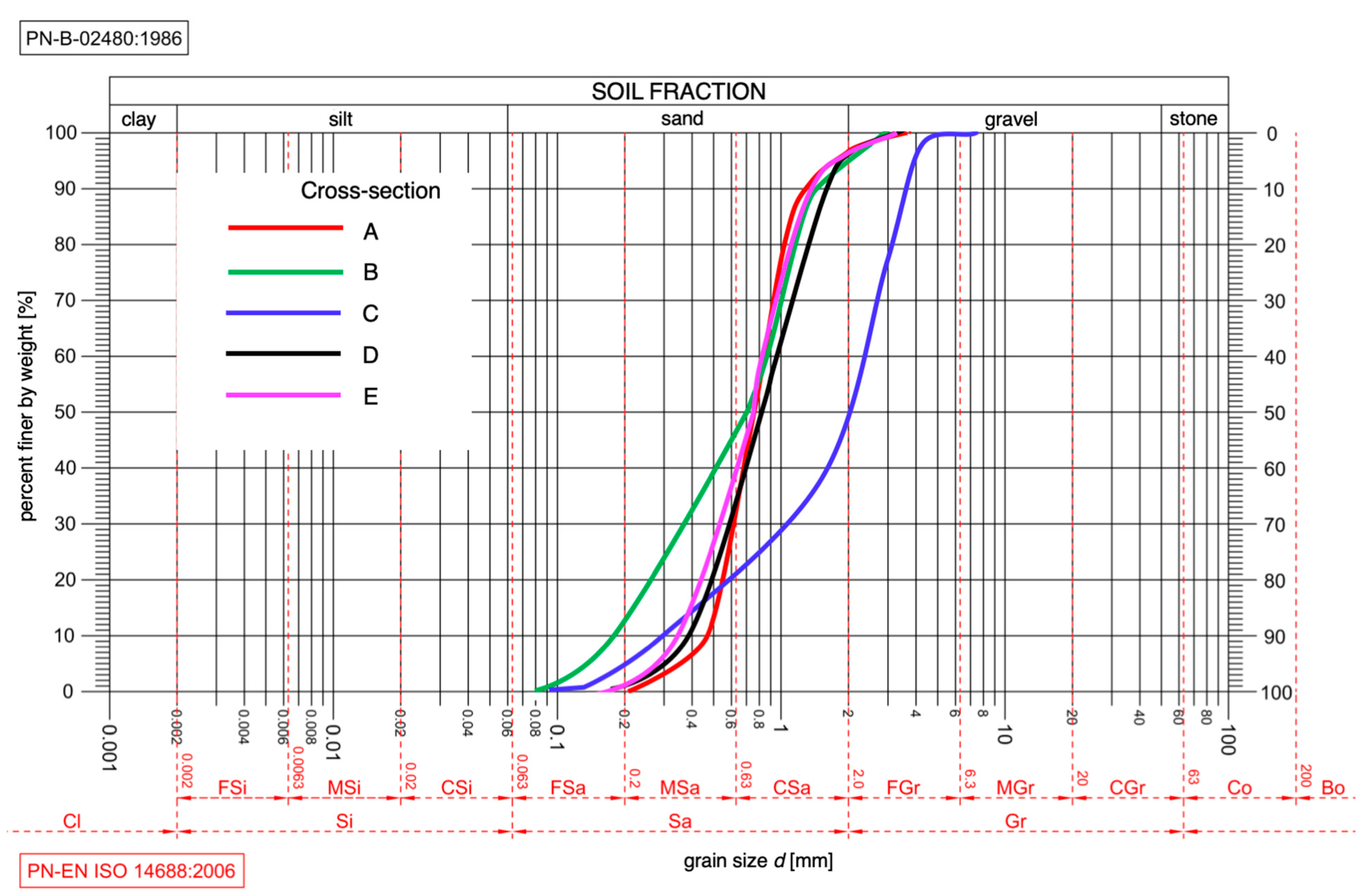
3.1. Granulometric Properties

The studied river section was characterized by the bed material granulometric variation and the cross-sectional shape of the riverbed (Figure 10). Granulometric analysis was performed on three samples, which were taken at the upper site (cross-sections A and B), at the tailwater site, in the energy dissipation basin region (cross-section C) at the downstream (cross-sections D, and E) (Table 1, Figure 11). If the following inequality is met, (d50/d10) > (d90/d50), that means that the examined reach could be characterized by the predominance of fractions smaller than d50 (asymmetry toward fine fractions). Inversely, failure to meet this inequality indicates the predominance of larger fractions.
It was reported that the highest unevenness of grain size, as measured by the uniformity coefficient Cu = d60/d10, occurred in the immediate vicinity of the structure (cross-sections B and C). The highest Cu value was observed in this section, thus allowing the soil to be classified as nonuniform with a significant predominance of the fraction smaller than d50. The residual cross-sections exhibited a consistent granularity throughout. Specifically, sections A and E, which are the farthest from the structure, displayed homogeneity in the distributions of particle diameters larger and smaller than d50.

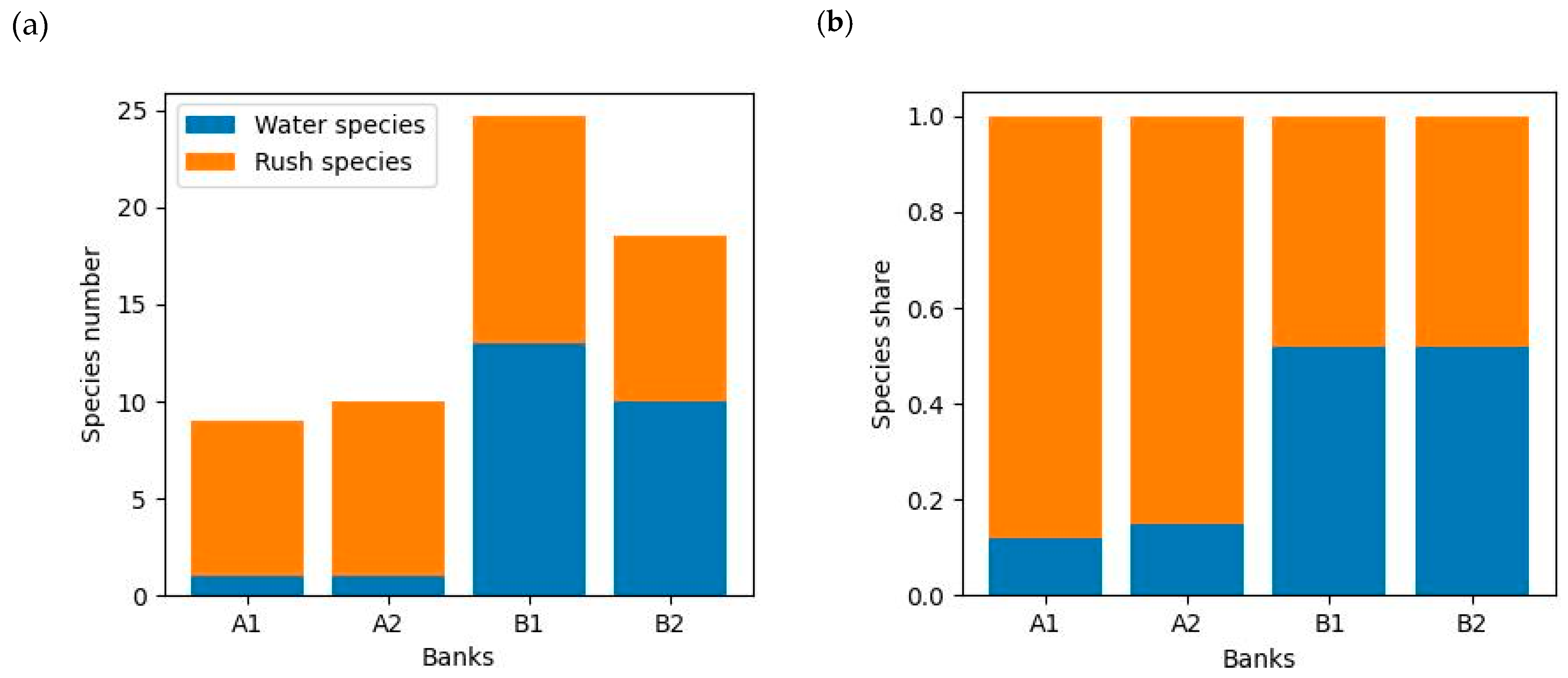
3.2. Total Species Number

In order to evaluate the effect of the weir on the diversity of the vegetation, an initial comparison was made between the total number of species per plot (Figure 12).
The total species number was significantly (p < 10−6) higher upstream (23.7) than downstream (10.3). There was also a significant (p < 10−6) difference between the banks observed, especially in the upstream area (27.8 species for B1 and 20.5 species for B2).

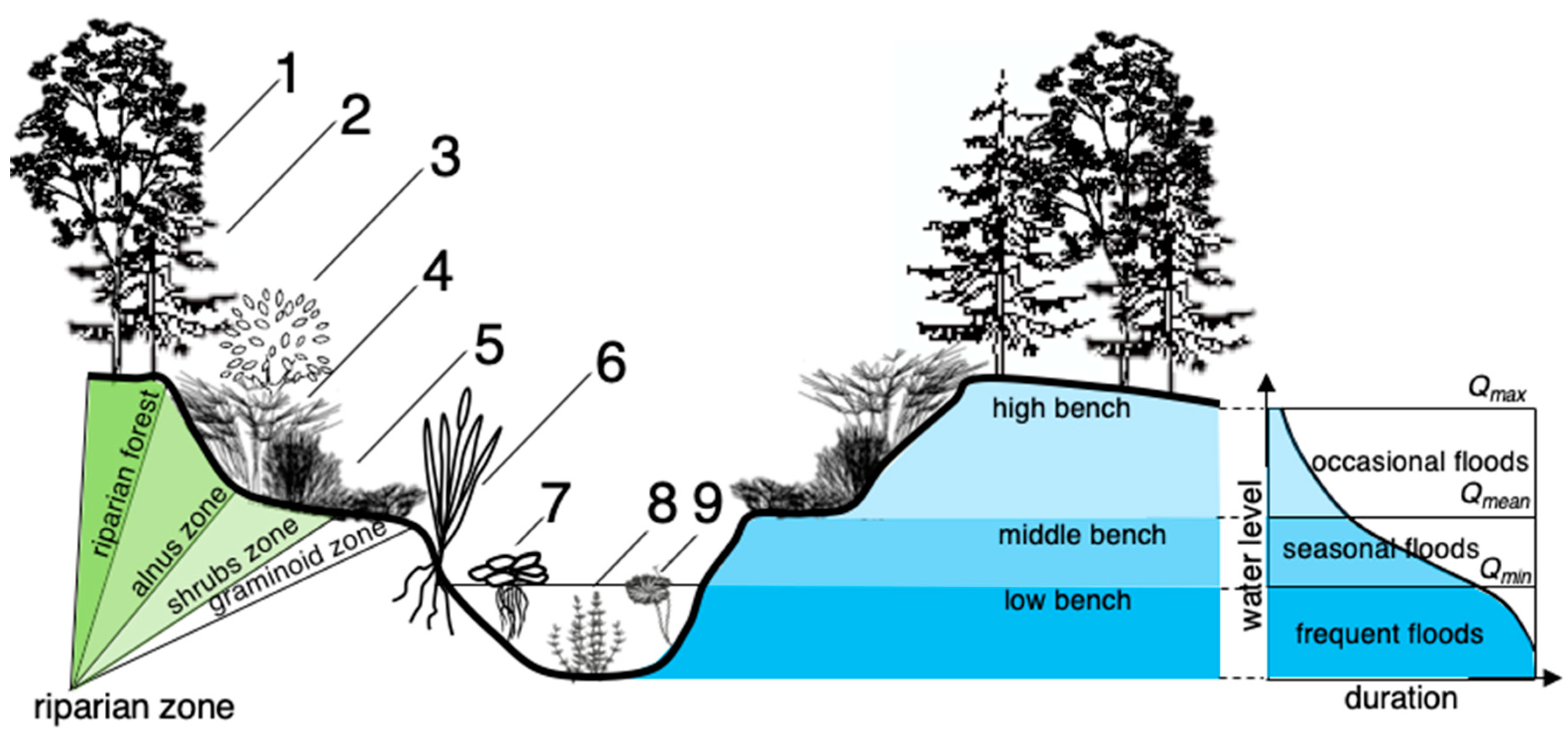
3.3. Water and Rush Species

The next step assessed the water and rush species’ proportions (Figure 13).
A remarkably higher (p < 10−6) number of water species was observed in the upstream area and in the differences between banks (p = 0.02). In the downstream area, mainly 1.4 water species were observed, and, in the upstream, 11.3 species were noticed. The number of rush species persisted similarly (p = 0.74) on both weir sides (10.4 species upstream and 8.1 species downstream).
The difference was especially noticeable considering the proportions of the species. The downstream domination was characterized by rush species (85%), and, on the upstream, there was a similar share of rush (47%) and water (53%) species. Interestingly, there was no difference (p = 0.83) between the banks.

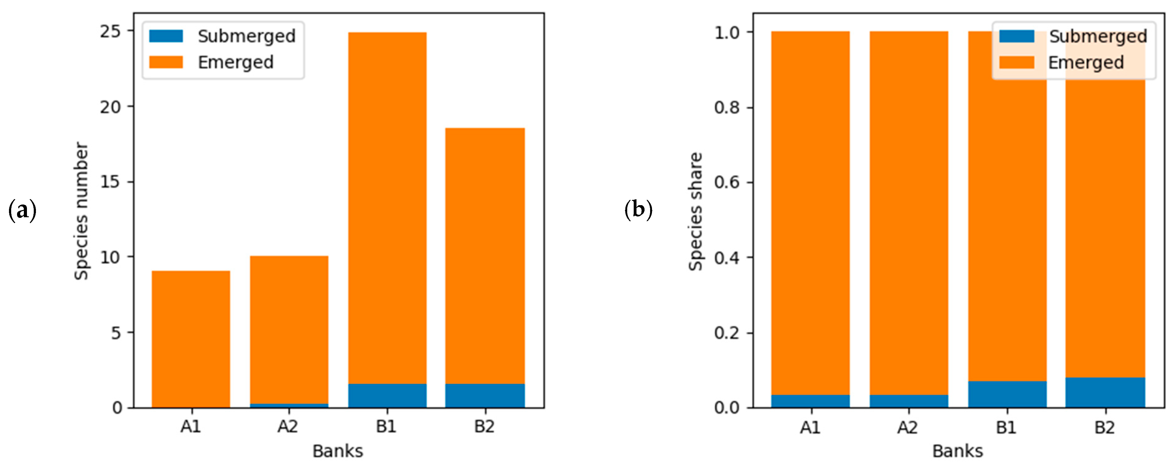
3.4. Submerged and Emerged Species

The prevalence of emerging species in the river undoubtedly establishes the dominance of flora in the ecosystem. The mean share of submerged species was only 6.6%, which corresponds to 0.9 species per plot (Figure 14). However, a significant difference (p = 0.000016) upstream and downstream of the weir was observed. In the downstream zone, submerged species were almost absent (mean of 0.3 species per plot); in the upstream zone, there was a mean share of 1.8 species per plot. The differences between the banks were elusive (p = 0.76).

3.5. Characteristic Species

In review of the chi2 test results, we identified a pool of species occurring mainly in the upstream zone and a group of species found on both sides of the weir. No species preferred the downstream site (Table 2).
The upper and lower structure stands were characterized by the variation in the watercourse’s prevailing hydraulic conditions. Upstream of the closures, the accumulation of water resulted in increments of water depth; thus, a decrease in the stream velocity relative to the lower site could be noticed. The aquatic vegetation morphology reflected the varying flow conditions. According to Järvelä [27], hydraulic conditions most significantly characterize the development of aquatic vegetation in rivers. Simultaneously, the hydraulic resistances and the morphology shaped by them constitute a feedback character, thereby influencing each other. This is one of the processes involved in forming a dynamic equilibrium in riverbeds [28,29].
The upstream water surface exhibited a prevalence of free-floating organisms, including Lemna minor, Lemnatrisculca, Utricularia vulgaris, and Potamogetonnatans, which are known to thrive in eutrophic waters with elevated temperatures. Furthermore, plants possessing supple stems that are capable of floating effortlessly within the water stream and that preferentially grow in substrates that are rich in organic matter, such as Batrachiumcircinatum, were observed in the upstream region. Additionally, a region comprised of stiff yet slender-stemmed rushes, such as Eleocharis palustris, could withstand the free-floating water’s flow. Our research findings, specifically Hypotheses 1 and 2, validate these observations.
The water surface upstream was characterized by free-floating species, which (for example, Lemna minor, Lemnatrisculca, Utricularia vulgaris, and Potamogetonnatans) could be recognized as occurring in waters with high organic content (eutrophic), and were well able to tolerate higher water temperatures. Plants with flexible stems that float freely in the depths of the water, preferably growing in a substrate rich in organic matter (for example, Batrachiumcircinatum), were also found upstream. Furthermore, there was also a zone of rushes with stiff but thin stems that were able to resist the current of free-floating water (for example, Eleocharis palustris). Therefore, the research confirmed Hypotheses 1 and 2.
According to Kazem et al. [29], downstream of the weir, the influence of vegetation causes a series of water flow disturbances, and this series is characterized by high velocity and high kinetic energy, as well as being not dispersed in the immediate region of the structure (Hypothesis 1). Kármán vortices are formed behind the plants rooted in the bottom in the detachment area behind the plant. These vortices cause periodic changes (pulsation) in the pressure, which then disappear due to kinetic energy dissipation. Vegetation can act as a barrier, deflecting the fluid flow around the plants, or as an obstacle, disrupting the flow and creating eddies and vortices. The presence of vegetation can alter the fluid flow, thus creating more complex and variable patterns of vortices in the wake of an object.
In the lower stand of the structure, there were few species with upright, straight-rising, usually branched stems and thick, robust rhizomes (Siumlatifolium, Rumexhydrolapathum). The present research indicates that the data support Hypothesis 3, as comparable outcomes were observed. Specifically, the degree of vegetation covering the water surface was significantly lower in the downstream region compared to the upstream area. Based on the study results, it can be inferred that the upstream zone provides a more conducive environment for vegetation growth and consequent biodiversity enhancement. This finding is consistent with previous research by Bredenhand and Samways [30] and confirms Hypotheses 2 and 3. Conversely, a lower-height vegetation stand may harbor species with certain traits that enable them to withstand the velocity pulsations and varied flow directions, such as sturdy stems, robust root systems, and elongated, sharp leaves.

4. Conclusions

The results offer insights into the influence of small hydrotechnical structures on water and rush plant species composition using the Świder River as an illustrative example. The Świder River represents small lowland rivers, which are prevalent in Poland. Typically, lowland rivers have a relatively limited variety of plant species. However, our study reveals that constructing a weir as an anthropogenic intervention can increase the growth of water and rushes plants due to its regulation of water flow and depth in the river. Evident dissimilarities in the granulometric composition between the upper and lower strata of the structure were observable, thereby potentially serving as a foundation not only for the development of characteristic alluvial bedforms, but also for the establishment of distinct plant species. Increasing the diversity of water and rushes plants is significant for strengthening the biodiversity of water ecosystems in the agricultural landscape in Poland. In recent years, the disappearance of water reservoirs in the agricultural landscape has been observed, e.g., due to climate changes (warming and land use), which also affect the loss of natural vegetation represented by aquatic and rush plant species.
Hydrotechnical structures, such as small weirs regulating water flow, facilitate plant communities’ emergence in aquatic environments, particularly species that thrive in highly turbulent and rapidly changing water currents. Additionally, vegetation can significantly impact the development of Kármán vortices, particularly in environments with consistent fluid flow. This can have practical implications for various systems, including wind energy production. Research has shown that vegetation can increase the frequency and strength of Kármán vortices. This can have important implications for various fields, such as engineering and ecology. For example, the presence of vegetation near bridges or other structures can increase the risk of vibration and damage due to Kármán vortex shedding.
Water and rush plant species serve as valuable natural aquatic habitats, which are currently inadequately represented in the agricultural regions of Poland. Land-living organisms, i.e., birds and small mammals, also need water and rush shelters for their well-being and the increased biodiversity of the region. It is important that the design and implementation of hydrotechnical structures be based on scientific research and consider local ecological conditions to minimize negative effects on the aquatic environment and to maximize the benefits to biodiversity. The positive effects of hydrotechnical structures on plant species composition can be used to improve the overall health and diversity of aquatic ecosystems in similar lowland rivers not only in Poland, but also in other regions.
  • Diverse habitats can be created for different plant species by designing and constructing a variety of hydraulic structures that create conditions with varying degrees of shading. This increases the biodiversity of the aquatic ecosystem.
  • The competent design of hydrotechnical structures can help create ecological corridors that allow plants and animals to migrate between various river zones. This can contribute to gene exchange and maintain healthy populations.
  • Weirs can reduce the fluctuations in river water levels. Then, stable water levels can create favorable conditions for vegetation, thereby reducing extreme environmental changes that could affect species that are sensitive to water fluctuations (swordfish, European catfish, pike, etc.).
  • The use of hydraulic structures to regenerate natural wetlands can help restore habitats for specialized plant species that have adapted to such conditions.
  • Hydraulic structures can be used to control invasive plant species by introducing physical barriers or by carrying out remedial measures to maintain a healthy species composition.
  • The systematic monitoring of vegetation along river courses and the impact of hydrotechnical structures analyses can provide valuable information on the effectiveness of measures and the needed adjustments to improve the health and diversity of aquatic ecosystems.
While the study highlights the positive impact of constructing weirs on water and rush plant species, it should also acknowledge any potential negative consequences or trade-offs associated with these anthropogenic interventions:
  • The hydrotechnical development of the riverbed leads to the stabilization of conditions above the water surface; however, in the lower position of the structure, unfavorable conditions may be created for some plant species, which poorly tolerate periodically low water surface levels or are not suitable for the constant availability of a certain water level. The construction of weirs may lead to a change in the natural water flow conditions, which may affect the availability of water for the vegetation on the banks and bottom of the river.
  • Weir construction may lead to changes in breeding habitats for aquatic vegetation. Nesting plants, such as species associated with submerged areas, may have difficulty reproducing, as these structures may disrupt their natural reproductive cycles.
  • Fluctuations in the water levels caused by weir operations can contribute to increased erosion of the river banks. This can lead to the loss of bank vegetation habitats and changes in the river ecosystem.
  • Vegetation on the riverbed and banks can be sensitive to changes in access to light. The construction of weirs may affect the shading of some areas, which may have a negative impact on plant species that require intense sunlight for photosynthesis.
Creating a vegetation structure within the weir area requires careful consideration of various factors, including hydrological conditions, native plant species, the river ecosystem, and the purpose of construction. Practical recommendations for managing the area adjacent to the hydrological tunnel structure can be summarized as follows:
-
First and foremost, prior to commencing the construction project, a thorough understanding of the river ecosystem where the vegetation structure will be established is of utmost importance. Conducting scientific research and consulting with experts can aid in selecting suitable plant species and determining the most appropriate areas for development.
-
Preferring native plant species that naturally occur in the region is advisable. This approach reduces the risk of disrupting the existing ecosystem and contributes to the preservation of biodiversity.
-
Planning of the vegetation structure should aim to create diverse habitats. Such planning must take into account the location of the structure (whether it is situated on the upper or lower part of the weir), which is characterized by varying water depths, shallow coastal zones, landforms, and areas with natural bends, in order to promote a diversity of vegetation and provide favorable conditions for different species.
-
In the lower section of the weir, where there is an increased vulnerability to erosion, it is crucial to select plant species that are well adapted to retaining soil and stabilizing the ground.
-
Following the completion of the construction project, consistent and vigilant monitoring of the vegetation’s condition and its effects on the ecological landscape is imperative.
Future research directions will depend on the changing needs and challenges of urbanization, climate change, and technological development. Research in this area is crucial for sustainable development, the protection of aquatic ecosystems, and the preservation of biodiversity. Future research directions regarding the topic of the impact of technical development on vegetation structure may focus on identifying optimal patterns and solutions for technical development that minimize the negative impacts on vegetation structure. This may include the development of guidelines for the design of hydraulic infrastructure that take into account the needs of vegetation. It is worth emphasizing the role of modeling studies and simulations in this regard. Ecological evaluation of the existing structures, on the other hand, could provide results for building a database that, enriched over time, could provide a basis for introducing artificial intelligence algorithms. These, in turn, are a very useful tool for optimizing solutions in qualitative and quantitative terms.

Author Contributions

Conceptualization, M.K. and F.C.; Methodology, M.K., B.F.-P. and F.C.; Validation, M.O. and B.F.-P.; Formal analysis, M.O.; Investigation, M.K., F.C., A.S. and B.F.-P.; Writing—original draft preparation, M.K., B.F.-P. and F.C.; Writing—review and editing, B.F.-P. and F.C. Visualization, M.K., A.S. and M.O.; Supervision, B.F.-P.; Funding acquisition, F.C., M.K., and B.F.-P. All authors have read and agreed to the published version of the manuscript.

Funding

This research received no external funding.

Institutional Review Board Statement

Not applicable.

Informed Consent Statement

Not applicable.

Data Availability Statement

Not applicable.

Conflicts of Interest

The authors declare no conflict of interest.

References

  1. Wollny, J.T.; Otte, A.; Harvolk-Schöning, S. Riparian plant species composition alternates between species from standing and flowing water bodies—Results of field studies upstream and downstream of weirs along the German rivers Lahn and Fulda. Ecol. Eng. 2019, 139, 105576. [Google Scholar] [CrossRef]
  2. Wollny, J.T.; Bergmann, W.; Otte, A.; Harvolk-Schöning, S. River regulation intensity matters: Riverbank vegetation is characterized by more typical riverbank plant species with increasing distance from weirs. Ecol. Eng. 2021, 159, 106082. [Google Scholar] [CrossRef]
  3. Mueller, M.; Pander, J.; Geist, J. The effects of weirs on structural stream habitat and biological communities. J. Appl. Ecol. 2011, 48, 1450–1461. [Google Scholar] [CrossRef]
  4. Almeida, E.F.; Oliveira, R.B.; Mugnai, R.; Nessimian, J.L.; Baptista, D.F. Effects of Small Dams on the Benthic Community of Streams in an Atlantic Forest Area of Southeastern Brazil. Int. Rev. Hydrobiol. 2009, 94, 179–193. [Google Scholar] [CrossRef]
  5. Brooks, A.J.; Wolfenden, B.; Downes, B.J.; Lancaster, J. Barriers to dispersal: The effect of a weir on stream insect drift. River Res. Appl. 2018, 34, 1244–1253. [Google Scholar] [CrossRef]
  6. Włodarczyk, A. The impact of Konstancin-Jeziorna weir on the quality and quantity of water resources and phytocenosis of Jeziorka River. Sci. Rev. Eng. Environ. Sci. 2006, 2, 121–129. [Google Scholar]
  7. Anggraheni, D.; Makrup, L.; Pratiwi, W.; Virgiawan, A. Hydraulic jump generation by weir model and leap length study for practice purpose. Int. J. Civ. Eng. Technol. 2017, 8, 1107–1119. [Google Scholar]
  8. Mossa, M.; Meftah, M.B.; De Serio, F.; Nepf, H.M. How vegetation in flows modifies the turbulent mixing and spreading of jets. Sci. Rep. 2017, 7, 6587. [Google Scholar] [CrossRef] [PubMed]
  9. Majewski, W. Hydraulic Model Tests in Water Engineering; Institute of Meteorology and Water Management, National Research Institute: Warsaw, Poland, 2019. (In Polish) [Google Scholar]
  10. Knight, D.W.; Shiono, K. River channel and floodplain hydraulics, floodplain processes. In Floodplain Processes; Anderson, M.G., Walling, D.E., Bates, P.D., Eds.; John Wiley and Sons Ltd.: Hoboken, NJ, USA, 1996. [Google Scholar]
  11. Västilä, K. Flow–Plant–Sediment Interactions: Vegetative Resistance Modeling and Cohesive Sediment Processes. Ph.D. Thesis, Aalto University, Aalto, Finland, 2015. [Google Scholar]
  12. Ennos, A.R. The aerodynamics and hydrodynamics of plants. J. Exp. Biol. 1999, 202, 3281–3284. [Google Scholar] [CrossRef]
  13. Wetzel, R.G. Land–water interfaces: Larger plants. Limnology 2001, 18, 527–575. [Google Scholar] [CrossRef]
  14. Tang, H.; Yuan, S.; Cao, H. Theory and Practice of Hydrodynamic Reconstruction in Plain River Networks. Engineering 2022, in press. [Google Scholar] [CrossRef]
  15. Ciullo, A.; Bruijn, K.M.; Kwakkel, J.H.; Klijn, F. Accounting for the uncertain effects of hydraulic interactions in optimising embankments heights: Proof of principle for the IJssel River. J. Flood Risk Manag. 2019, 12, e12532. [Google Scholar] [CrossRef]
  16. Thai, T.H.; Tri, D.Q. Combination of hydrologic and hydraulic modeling on flood and inundation warning: Case study at Tra Khuc-Ve River basin in Vietnam. Vietnam J. Earth Sci. 2019, 41, 240–251. [Google Scholar] [CrossRef]
  17. Calabresi, G.; Colleselli, F.; Danese, D.; Giani, G.; Mancuso, C.; Montrasio, L.; Nocilla, A.; Pagano, L.; Reali, E.; Sciotti, A. Research study of the hydraulic behaviour of the Po River embankments. Can. Geotech. J. 2013, 50, 947–960. [Google Scholar] [CrossRef]
  18. Dawson, F.H. Water Flow and the Vegetation of Running Waters. In Vegetation of Inland Waters; Springer Netherlands: Dordrecht, The Netherlands, 1988; pp. 283–309. [Google Scholar]
  19. Tang, C.; Yi, Y.; Jia, W.; Zhang, S. Velocity and turbulence evolution in a flexible vegetation canopy in open channel flows. J. Clean. Prod. 2020, 270, 122543. [Google Scholar] [CrossRef]
  20. Matuszkiewcz, W. Guide to the Determination of Plant Communities in Poland; Polish Scientific Publishing House PWN: Warsaw, Poland, 2012. (In Polish) [Google Scholar]
  21. Halabowski, D.; Lewin, I. Impact of anthropogenic transformations on the vegetation of selected abiotic types of rivers in two ecoregions (Southern Poland). Knowl. Manag. Aquat. Ecosyst. 2020, 421, 35. [Google Scholar] [CrossRef]
  22. BN-62/6738-05; Hydrotechnical Concrete—Concrete Tests. Polish Committee for Standardization: Warsaw, Poland, 2005.
  23. EN 1992-1-1:2008; Eurocode 2: Design of Concrete Structures—Part 1-1: General Rules and Rules for Buildings. European Committee for Standardization: Brussels, Belgium, 2008.
  24. Adamo, N.; Al-Ansari, N.; Sissakian, V.; Laue, J.; Knutsson, S. Dam Safety: Technical Problems of Ageing Concrete Dams. J. Earth Sci. Geotech. Eng. 2020, 10, 241–279. [Google Scholar]
  25. Drągowski, Z. Water Management Instructions for Damming the Waters of the Świder River on a Reinforced Concrete Weir at km 21 + 340 Wola Karczewska; Wiązowna Commune: Warsaw, Poland, 2013. (In Polish) [Google Scholar]
  26. Braun-Blanquet, J. Pflanzensoziologie, 2nd ed.; Springer: Wiena, Austria, 1951. [Google Scholar]
  27. Jarvela, J. Flow resistance of flexible and stiff vegetation: A flume study with natural plants. J. Hydrol. 2002, 269, 44–54. [Google Scholar] [CrossRef]
  28. Coscarella, F.; Penna, N.; Ferrante, A.P.; Gualtieri, P.; Gaudio, R. Turbulent Flow through Random Vegetation on a Rough Bed. Water 2021, 13, 2564. [Google Scholar] [CrossRef]
  29. Kazem, M.; Afzalimehr, H.; Sui, J. Characteristics of Turbulence in the Downstream Region of a Vegetation Patch. Water 2021, 13, 3468. [Google Scholar] [CrossRef]
  30. Bredenhand, E.; Samways, M.J. Impact of a dam on benthic macroinvertebrates in a small river in a biodiversity hotspot: Cape Floristic Region, South Africa. J. Insect Conserv. 2009, 13, 297–307. [Google Scholar] [CrossRef]
Figure 1. Hydraulic conditions (a) on the weir and (b) on the main channel and the floodplain, where Qw is the water discharge [m3s−1]; and v1 and v2 are the stream velocities upstream and downstream of the structure, respectively. A is the upper stand of the structure; B is the overflow area; C is the hydraulic jump; D is the velocity equalization cross-section; and E is the local scour region (own elaboration).
Water 15 03189 g001
Figure 2. The weir with flushing channel scheme, where A is the gate valve; B is the flushing channel; C is the substrate; D is the pile sheet; E is the flap closure; F is the footbridge; G is the closure; H is the thin grating; and I is the channel (own elaboration).
Water 15 03189 g002
Figure 3. Distribution of hydrodynamic forces acting on submerged plant, where h1, h2, and h3 are the water depths [m]; P1, P2, and P3 are the hydrodynamic pressure levels impacting the weir area [N]; p, p1, p2, and p3 are the hydrostatic pressure levels [Pa]; γ is the water volume weight [kg m3]; L is the lifting force [N]; and F is the acceleration force [N] (own elaboration).
Water 15 03189 g003
Figure 4. Stream expansion downstream of the weir region (a) at the outlet from a narrower cross-section channel to a broader cross-section channel, where A is the gradually widened channel; and B is the recirculation zone; stream expansion downstream of the weir region (b) at the weir where only central gate is opened, where A is the parallel stream lines zone; B is the vertical axis eddies zone; and C is the stream velocity concentration zone (own elaboration).
Water 15 03189 g004
Figure 5. Cross-sectional conveyance module K assignment procedure, where Ki are conveyance modules for subsections, which are described by roughness coefficients ni.
Water 15 03189 g005
Figure 6. Well-developed river vegetation zoning, where 1 represents deciduous trees; 2 represents coniferous trees; 3 represents alnus trees; 4 represents high grass and shrubs; 5 represents low grass; 6 represents emergent plants and roots in water; 7 represents floating species; 8 represents submerged species; 9 represents rooted floating species; Qmin is the minimal (biological) discharge; Qmean is the mean discharge; and Qmax isthe maximal discharge (own elaboration).
Water 15 03189 g006
Figure 7. Weir location generated by QGIS software 3.32 Lima using WMS system implementation: (a) topographical map; (b) photogrametric map, including the surrounding communities.
Water 15 03189 g007
Figure 8. Concrete weir on Świder river (downstream view) (Authors’ property).
Water 15 03189 g008
Figure 9. Study plot locations (red squares) on riverbanks (A1, A2, B1, and B2) downstream and upstream of the weir.
Water 15 03189 g009
Figure 10. Locations of cross-sections A–E (self-development), where Qw is the water discharge, *—discretized cross section.
Water 15 03189 g010
Figure 11. Soil granulation in cross-sections A–E.
Water 15 03189 g011
Figure 12. Number of plant species per plot.
Water 15 03189 g012
Figure 13. Number (a) and share (b) of water and rush species.
Water 15 03189 g013
Figure 14. Number (a) and share (b) of submerged and emerged species.
Water 15 03189 g014
Table 1. Granulometric parameters of soil samples.
Cross-Sectiond10d50d60d90CuGranulation Uniformityd50/d10d90/d50Fraction Predominance
[m][m][m][m][-][-][-][-]
A0.00050.00070.00080.00111.70U *1.531.53none
B0.00020.00070.00100.00125.28N *3.891.71d < d50 (MS **)
C0.00030.00200.00220.00357.33N6.671.75d < d50 (S **)
D0.00040.00080.00090.00132.30U2.051.59d < d50
E0.00030.00060.00070.00122.19U1.941.94none
Note(s): * Cu—soil granulation uniformity coefficient; U—uniform; N—nonuniform; ** MS—moderately significant; S—significant.
Table 2. Frequency of species in the upstream and downstream zones. Species preferring upstream site are marked green, and species frequent in both zones are marked blue.
SpeciesUpstreamDownstreamp
Lemna minor0345.5 × 10−9
Lemnatrisculca0339.2 × 10−9
Hydrocharismorsus-ranae0312.5 × 10−8
Batrachiumcircinatum0281.2 × 10−7
Hottoniaplaustris0272.0 × 10−7
Eleocharis palustris0255.7 × 10−7
Nuphar luteum1278.9 × 10−7
Utricularia vulgaris0249.6 × 10−7
Alismaplantago-aquatica1244.2 × 10−6
Callitriche verna0191.3 × 10−5
Spirodelapolyrhiza0191.3 × 10−5
Ceratophyllumdemersum3261.9 × 10−5
Stratoidesaloides0182.2 × 10−5
Potamogetonnatans3245.3 × 10−5
Numphaea alba1195.7 × 10−5
Glyceria maxima4265.9 × 10−5
Myriophyllum spicatum0125.3 × 10−4
Potamogetonlucens6241.0 × 10−3
Nymphaea canadensis084.6 × 10−3
Rumexhydrolapathum11279.4 × 10−3
Iris pseudoacorus5170.011
Siumlatifolium14290.022
Galiumpalustre18330.035
Carexacutiformis21330.102
Typha latifolia33220.138
Carexelata21260.466
Mentha aquatica32280.605
Phalarisarundinacae26280.785
Phragmites australis29270.789
Acorus calamus30320.799
Carexgracilis26250.889
Rorippaamphibia33320.901
Sagittariasagitiifolia29291
Disclaimer/Publisher’s Note: The statements, opinions and data contained in all publications are solely those of the individual author(s) and contributor(s) and not of MDPI and/or the editor(s). MDPI and/or the editor(s) disclaim responsibility for any injury to people or property resulting from any ideas, methods, instructions or products referred to in the content.

