1. Introduction
Global warming has become a global consensus among governments. Under the trend of global warming, precipitation changes have become more extreme. Many studies have shown that extreme precipitation is often associated with flooding. The increasing frequency and intensity of extreme-precipitation events have caused severe social and ecological impacts and destructive power, and have thus attracted increasing attention [
1,
2]. In addition, extreme precipitation is one of the 15 major natural disasters announced and focused on by the United Nations. It is the most frequent and one of the most severe damages caused by several disasters, which results in significant losses to the social, economic, and ecological environment [
3]. The study of the spatial and temporal distribution characteristics of extreme precipitation can provide a basis for decision-making and a theoretical foundation for government departments.
The Yangtze River Basin is home to an extensive water system that straddles three terrain levels in China. The Yangtze River, spanning a length of 6236 km and with an expansive watershed covering approximately 1.8 million
, holds the distinction of being the largest river in China and also encompasses a densely populated region [
4]. The monsoon climate’s impact results in an uneven distribution of precipitation, rendering the area susceptible to frequent floods and droughts, which are further exacerbated by water-scarcity issues. It has a complex topography and is influenced by both the southwest and southeast monsoons, resulting in an uneven spatial and temporal distribution of annual mean precipitation and heavy rainfall. Furthermore, the upper reaches are influenced by the Tibetan Plateau, making it an area sensitive and vulnerable to climate change [
5,
6]. Among them, the Yangtze River Delta region is one of the fastest-growing regions in China in terms of economic development and urbanization [
7]. Since 1990, the frequency of extreme-precipitation events in this region has increased significantly, with a clear upward trend in the amount and frequency of extreme precipitation in the middle and lower reaches of the Yangtze River [
8]. Wang et al. [
9] concluded that not only is there a perfect correlation between the extreme-precipitation index and total precipitation in the middle and lower reaches of the Yangtze River, but the extreme-precipitation index in this region also showed an increasing trend from 1960 to 2005. Extreme precipitation has shown a more pronounced increasing trend in the last 52 years, with an increased rate of 9.3 mm/10a [
10]. Additionally, extreme precipitation is characterized by more pronounced interannual fluctuations [
9,
10]. There are differences in the spatial distribution of extreme precipitation, with most of the significant upward trends in the extreme-precipitation index occurring in the upper Dongting Lake Basin, the lower reaches of the Yangtze River, and the Taihu Lake Basin [
11]. Zhou et al. [
1] concluded from a study of precipitation data in the Yangtze River Delta region in the last 53 years that extreme-precipitation frequency and total amount are higher in southwestern Zhejiang and southeastern coastal islands.
CMIP6 (Coupled Model Intercomparison Project in Phase 6) incorporates numerical simulations from 46 climate models in various countries worldwide to analyze possible future climate changes. CMIP6 focuses on answering essential questions in the design of numerical-simulation science experiments, including how the Earth system responds to external forcing and how to assess future climate change under the influence of internal climate variability, predictability, and scenario uncertainty [
12]. With higher spatial resolution and improved parameterization schemes than previous versions, the CMIP6 model can better describe the physical and biogeochemical processes of the climate system, and its outputs have been widely used in studies related to climate change and climate extremes [
13,
14]. CMIP6-MME significantly improves upon CMIP5-MME in the simulation of the spatial distribution and interannual variability of extreme-precipitation indices [
15,
16]. Currently underway, CMIP6 proposes the latest shared socioeconomic pathways (SSPs) that improve the long-standing problems of model bias and the poor quantification of radiative forcing in CMIP5 [
17]. The CMIP6 future climate-projection scenarios integrate shared socioeconomic pathways (SSPs) and representative concentration pathways (RCPs). Unlike earlier versions, the new scenarios include future social and economic developments such as population, economic development, ecosystems, resources, and social factors, as well as future mitigation, adaptation, and response efforts to climate change [
18].
Most Chinese studies concerning precipitation and extreme precipitation have primarily focused on larger regional scales, such as the global and national levels, with limited attention given to the Yangtze River Basin. Furthermore, there remains a dearth of investigations into the prospective spatial and temporal evolution trends of precipitation and extreme precipitation within the Yangtze River Basin under various SSP scenarios. To address this gap, the present paper assesses the simulation capability of 30 climate model datasets sourced from NASA Earth Exchange Global Daily Downscaled Projections (NEX-GDDP-CMIP6) for precipitation and extreme precipitation within the Yangtze River Basin, utilizing historical period observations (1985–2014). Three 21st-century scenarios (SSP1-2.6, SSP2-4.5, and SSP5-8.5) have been selected for evaluating the interannual variability and spatial trends of precipitation and extreme precipitation in the future, along with contrasts against the historical period. The overarching goal is to offer guidance for CMIP6 model selection in the examination of climate change within the Yangtze River Basin, as well as for enhancing extreme-precipitation-disaster forecasting and emergency management.
2. Materials and Methods
2.1. Study Area
The Yangtze River Basin (
Figure 1), spanning from 24° N to 35° N and 90° E to 122° E, ranks as the third-largest river basin globally. Encompassing 19 provinces, cities, and autonomous regions across eastern, central, and western China, the basin hosts an intricate water network. Encompassing a vast expanse of 1.8 million km
2, it constitutes 18.8% of China’s total land area [
16]. Despite its substantial average precipitation of 1126 mm over multiple years, the basin’s spatial distribution exhibits unevenness, manifesting a decreasing trend from the southeast to the northwest [
4,
6]. The basin experiences high population density, and owing to the impact of the monsoon climate, precipitation displays uneven distribution. Frequent occurrences of both floods and droughts, along with water-scarcity issues, stand out as significant challenges.
2.2. Data Source
The day-by-day precipitation observations in China encompass the EA05, APHRO, and CN05.1 datasets. Among these, the CN05.1 dataset stands out as the most suitable choice due to its higher spatial resolution and the greater number of observing stations compared to the other datasets, which have lower spatial resolution and fewer observing stations [
19]. The CN05.1 dataset, obtained by Wu et al. [
19] based on processed observations from 2416 ground-based meteorological stations in China, is used in this study. It covers the period 1961–2018 and has a grid resolution of 0.25° × 0.25°. Data for the future scenarios SSP1-2.6, SSP2-4.5, and SSP5-8.5 originate from the NEX-GDDP-CMIP6 dataset [
20]. This dataset comprises global downscaled climate scenarios obtained through simulations conducted by General Circulation Models (GCMs) within the context of the Coupled Model Intercomparison Project in Phase 6 (CMIP6). The dataset provides daily data at a resolution of 0.25° × 0.25°. The NEX-GDDP-CMIP6 dataset serves the purpose of furnishing a collection of high-resolution, globally encompassing, and bias-corrected climate change projections. These projections are designed to facilitate the assessment of climate change impacts on processes that exhibit sensitivity to fine-scale climate gradients and the influence of local topography on climatic conditions. Daily precipitation observations from 1985 to 2014 are employed to assess the simulation capability of 30 CMIP6 climate model datasets sourced from the NEX-GDDP-CMIP6 dataset. This assessment pertains to the spatial and temporal distribution of precipitation within the Yangtze River Basin. Each model’s simulation capability is evaluated and scored, subsequently guiding the assignment of distinct weighting coefficients based on the scores. This process culminates in the derivation of a weighted-ensemble average of the models.
The NEX-GDDP-CMIP6 dataset model information employed in this study encompasses historical climate-simulation data derived from the CMIP6 climate model, as well as future-scenario experimental data that integrate shared socioeconomic pathways (SSPs) and representative concentration pathways (RCPs). A comprehensive selection of multiple CMIP6 participating models was made for this study, encompassing 30 historical and future-scenario data releases, as detailed in
Table 1. In the “Variant” column, the letter “r” represents a specific number of experimental repetitions, “i” denotes a particular initial condition, “p” signifies a distinct set of physical parameters, and “f1” indicates a specific external forcing or radiative forcing. During the assessment phase of the historical climate model, daily precipitation data from 1985 to 2014 were employed. For the future-projection phase, the experimental daily precipitation scenario data for the years 2015–2100 were chosen, encompassing three distinct scenarios: SSP1-2.6, SSP2-4.5, and SSP5-8.5, which correspond to the sustainable-pathway scenario (low-forcing emissions), the medium-emissions pathway (medium-low radiative forcing), and the high-fossil-fuel-emissions pathway (high radiative forcing) for the three future forcing scenarios [
21].
2.3. Methods
2.3.1. Quantile Mapping
The quantile mapping method was used to perform bias revisions on the CMIP6 daily precipitation data. This method relies on the cumulative probability-distribution function to establish the transfer function, which can be based on either the theoretical probability distribution or the empirical probability distribution. However, some studies have shown that the first method is less effective in revising the precipitation extremes [
22]. In precipitation simulated by climate models, there is often a high number of gross rain days. To revise the precipitation days, the daily precipitation is sorted from large to small. Once the observed precipitation days are reached, the remaining precipitation is assigned a value of 0, resulting in a new daily precipitation series. Upon calculating the frequency of precipitation days using observed data within the historical period in the Yangtze River Basin, it was determined that the rs-MME data were attributed a value of 0 mm for precipitation amounts below 3.1199 mm, which represents the regional average. Next, the observed data from 1985 to 2014 (reference period) were used along with the CMIP6 model data to establish the transfer function:
where
F is the transfer function,
is the original output value of the pattern, and
is the revised value.
This paper employs the nonparametric transformation ROUANT [
22] to build the transfer function. The empirical cumulative probability-distribution function of the raw data output is made as close as possible to the observation in the reference period. Specifically, we use the following equation:
The established transfer function is then applied to the future period, resulting in revised data
, where:
Here, , and , represent the model data and their corresponding empirical cumulative distribution functions (CDFs) for the reference time period and future period, respectively, while and correspond to the observed data and their empirical CDF, respectively. We use a local linear least-squares regression approach for interpolation between the fitted transfer values.
2.3.2. Evaluating Model Skill
To assess the performance of each model more intuitively, we used Taylor plots [
23] based on the correlation coefficient, the ratio of standard deviation, and the regularized root-mean-square error of the model data to the observed data. To address the issue that the root-mean-square error does not satisfy the problem that the skill score should increase as the variance of the model data approaches the variance of the observed data in the case of relatively low correlation, we introduce the skill score
and improve it. We also introduce the skill score
to provide a quantitative description of the model’s simulation ability. The skill score equations are as follows:
Here, R is the correlation coefficient, is the maximum possible correlation coefficient, and is the ratio of the standard deviation of the simulated values to the observed values. The skill score approaches zero as the correlation becomes increasingly negative or as the model variance approaches zero or infinity. Conversely, as the correlation approaches its maximum value, the skill score approaches 1, indicating a more effective model simulation. Equation (5) places more emphasis on the importance of variance compared to Equation (4).
2.3.3. Model Variability Index
We introduced the Model Variability Index (MVI) [
24] to assess the simulation results of multi-year changes in regional mean precipitation-model simulations. The MVI is defined as follows:
where
denotes the inter-month standard deviation of each grid point in the simulated field, and
denotes the inter-month standard deviation of each grid point in the observed field. The standard deviation of monthly precipitation was calculated for each grid point in the region and subsequently averaged across all grid points within the same region. The MVI assumes values within a range greater than 0; the closer the MVI is to 0, the better it represents the ability to simulate interannual variability. The MVI is a dimensionless number.
2.3.4. Improved RS Evaluation Method
The improved rank scoring method [
25] is used to comprehensively evaluate each model, enabling a more intuitive and objective comparison of the simulation performance of different models. This method distinguishes between relative and non-relative error indicators, thus avoiding inconsistent evaluation results caused by the original method’s failure to differentiate these indicators. The rank score is given separately and calculated as follows for each element and evaluation index corresponding statistic:
Here,
is the rating value of the “
ith” model,
is the calculated value of the “
ith” model according to the specific evaluation index, and
and
are the maximum and minimum values of the corresponding evaluation index, respectively. In this study, the relative error evaluation index is the Model Variability Index (MVI) and the non-relative error evaluation index is the
and
skill scores. The RS value ranges from 0 to 1, where higher values indicate better performance. The total score is obtained by taking a weighted average of all evaluation index scores, with a higher total score indicating better simulation performance. The
and
skill scores are different indexes indicating the same feature, and thus they are given equal weights of 0.5, while other single indexes are given a weight of 1.0. Model results are affected by many factors, and the multi-model ensemble (MME) method is better for reducing model simulation uncertainty and is widely used in model simulation [
17]. Hence, within the model evaluation phase of this study, the simulation performance of 30 models was assessed. Utilizing the RS assessment method, scores were attributed to each model. Subsequently, to evaluate future precipitation and extreme precipitation in the Yangtze River Basin, distinct weighting coefficients were assigned based on the RS scores. This resulted in the creation of a multi-model weighted ensemble (rs-MME).
2.3.5. Multi-Model Weighted-Ensemble Mean
Due to the systematic bias of numerical models and the uncertainty in initial conditions, relying on a single “optimal” model can result in significant biases that influence the assessment of climate change impacts [
26]. Transitioning from a single numerical model to a multi-model ensemble forecast is an effective strategy to enhance model accuracy. In this study, we employ both multi-model ensemble (MME) averaging and multi-model weighted-ensemble averaging fusion, utilizing RS scores to assign weights, in order to achieve a multi-model weighted-ensemble average.
Here, represents the multi-modal ensemble average, denotes the simulation result of the “ith” model, indicates the result of the multi-modal weighted-ensemble average based on the RS score, and corresponds to the RS score of the “ith” model.
2.3.6. Extreme-Precipitation Index
The World Meteorological Organization Climate Committee (WMO-CCD) recommends 27 extreme climate indices, comprising 16 extreme temperature indices and 11 extreme-precipitation indices. The latter are categorized into absolute, relative, intensity, and persistence indices.
Table 2 provides a detailed list of these indices and their definitions. In this study, we utilize the 11 extreme-precipitation indices to evaluate the simulation performance of the revised rs-MME model data, aiming to assess its capability in replicating the intensity, frequency, and duration of extreme-precipitation events within the Yangtze River Basin. We then used these evaluations to predict the temporal and spatial changes of extreme precipitation under different SSP scenarios in the future.
3. Model Performance Evaluation
During the model evaluation stage, a range of evaluation metrics, including spatial correlation coefficients, standard deviations, and root-mean-square errors (RMSEs), were employed to assess the performance of the 30 models in replicating the spatial and temporal precipitation distributions from 1985 to 2014. Weighting coefficients were allocated to each model based on their respective RS scores, resulting in the derivation of a multi-model weighted-ensemble average. Subsequently, the multi-model weighted-ensemble average underwent refinement through the application of the quantile mapping method, leading to the formation of a revised multi-model weighted-ensemble average (rs-MME). This revised rs-MME was then utilized to appraise the models’ simulation capability concerning both precipitation and extreme precipitation during the historical period.
3.1. Precipitation-Simulation Performance Evaluation
The disparity between model data and observed data stands as a fundamental metric for evaluating the efficacy of model simulations. Illustrated in
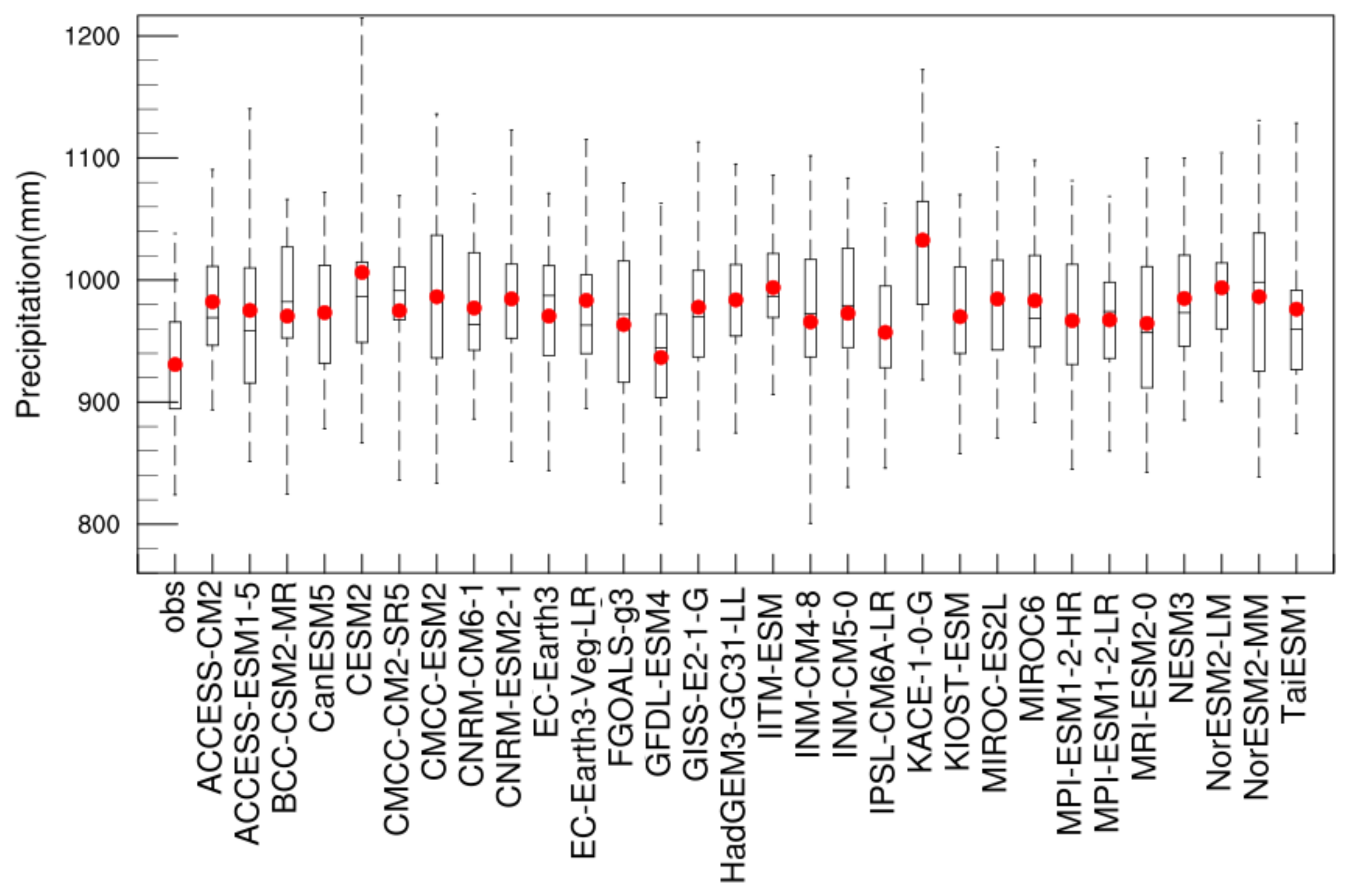
Figure 2 are box plots portraying the annual mean precipitation of each model’s data juxtaposed with observed data spanning the years 1985 to 2014. The figure reveals a notable coherence among the models’ simulation outcomes. The observed data display an average annual precipitation of 949.94 mm, with the median closely aligning with the average. The mean annual precipitation achieves a maximum value of 1049.90 mm, whereas the minimum rests at 832.06 mm. Examining the boxplot 25% and 75% positions, a concentration of mean annual precipitation in the range of 904.90 to 975.61 mm within the Yangtze River Basin becomes evident. With the exception of GFDL-ESM4, the remaining models generally exhibit an overestimation of annual precipitation within the Yangtze River Basin. The majority of simulated annual precipitation falls within the range of 950 to 1000 mm. Notably, the KACE-1-0-G model displays the most pronounced overestimation, registering a substantial 1064.47 mm.
From the evaluation indexes presented in
Table 3, it becomes evident that the spatial correlation coefficients depicting the correspondence between model data and observational data within the NEX-GDDP-CMIP6 dataset generally span the range of 0.68 to 0.72. Notably, the KACE-1-0-G model displays a relatively inferior spatial correlation coefficient for precipitation, registering only 0.6415. A significant enhancement in the spatial-simulation performance of precipitation emerges in contrast to the original CMIP6 data, indicating a substantial improvement across the CMIP6 dataset. The standard deviation ratios (SDRs) of simulated-model precipitation fields in relation to observed precipitation fields all remain below 1, denoting a reduction in precipitation fluctuations relative to actual conditions. However, these SDR values consistently surpass 0.9, with EC-Earth3 and EC-Earth3-Veg-LR models exhibiting SDRs that closely approach 1, surpassing the threshold of 0.98. The standardized root-mean-square errors (RMSEs) for simulated-model precipitation fields in comparison to observed fields consistently fall within the range of 0.36 to 0.44. A lower standardized RMSE value indicates a closer alignment between the simulated precipitation field and the observed field, underscoring the proximity between the two datasets.
Furthermore, the distribution range of skill score
for each model ranges from 0.80 to 0.85, while the distribution range of skill score
ranges from 0.39 to 0.46, as per Equations (4) and (5). From the skill scores
and
, it can be inferred that CanESM5 is relatively good at simulating the spatial distribution of precipitation, with both skill scores being in the top five. The results from various evaluation metrics demonstrate that the 30 sets of climate model data exhibit minimal variability across each metric. This suggests a consistency in the simulation of precipitation over the historical period among the different model datasets. To gain a more intuitive comprehension of the simulation performance of each model, the RS rating method was employed to rank them. Evaluation metrics encompassing
,
, and MVI were selected to comprehensively assess the simulation efficacy of each model with regard to spatial distribution and temporal evolution. As depicted in
Table 3, the leading models in terms of their performance are CanESM5, CNRM-ESM2-1, KIOST-ESM, CMCC-ESM2, and ACCESS-ESM1-5.
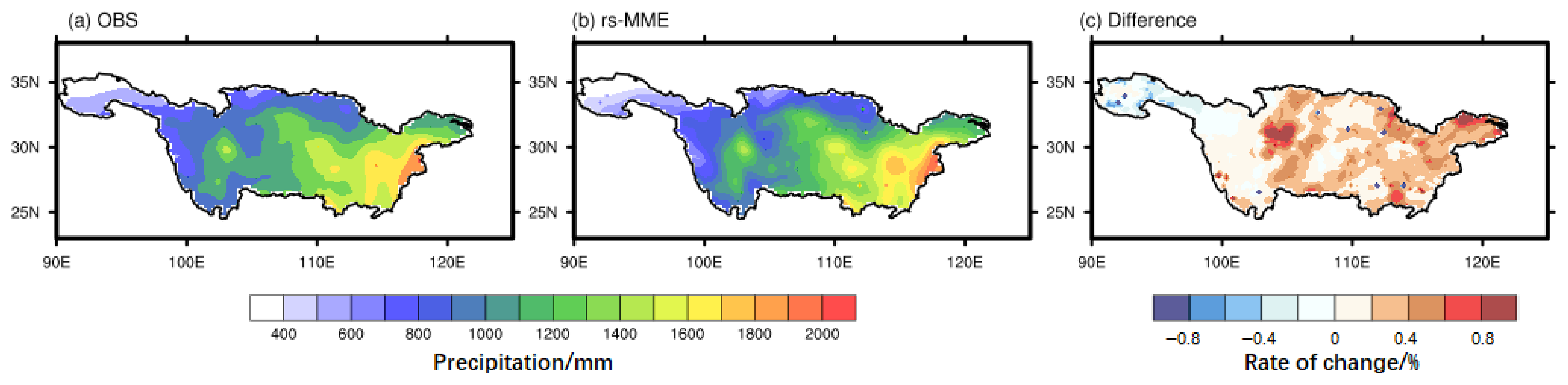
After conducting the aforementioned analysis, we proceed to adjust the bias using the weighted pooled-mode average of the RS scores. The observational data, the revised rs-MME outcomes, and the corresponding rate of change in their discrepancies will be presented individually. As depicted in
Figure 3, the average annual precipitation across the Yangtze River Basin exhibits a west-to-east increase, ranging from less than 400 mm at the river’s source to 1200 mm in the middle reaches, and reaching 1600 mm in the lower reaches and mouth of the Yangtze River. The revised rs-MME demonstrates improved accuracy in capturing the intensity and the eastward rise in the spatial distribution of average annual precipitation in this area. The plot depicting the rate of change in the difference between modeled and observed annual mean precipitation (
Figure 3c) indicates that the revised rs-MME marginally underestimates mean annual precipitation by approximately 0.4% in the headwaters and upstream regions of the Yangtze River Basin, and slightly overestimates it by less than 0.6% in the middle and lower reaches of the Yangtze River.
As depicted in
Figure 4a, annual precipitation within the Yangtze River Basin exhibits a rise of approximately 20 mm·
at the headwaters, an increase of around 80 mm·
in the northern section of the middle reaches and the southern region of the lower reaches, and a decrease of about 40 mm·
in the southern areas of the middle and upper reaches. In
Figure 3b, the revised rs-MME model effectively captures the increasing trend at the source of the Yangtze River Basin and the declining trend in the southern portion of the middle and upper reaches, yet the simulation intensity is slightly exaggerated. However, the model’s representation of the annual precipitation trend in the middle and lower reaches of the Yangtze River Basin is less satisfactory. While the revised rs-MME model provides an improved spatial distribution of annual precipitation, its effectiveness in simulating the trend of annual average precipitation is limited.
3.2. Extreme-Precipitation Performance-Simulation Evaluation
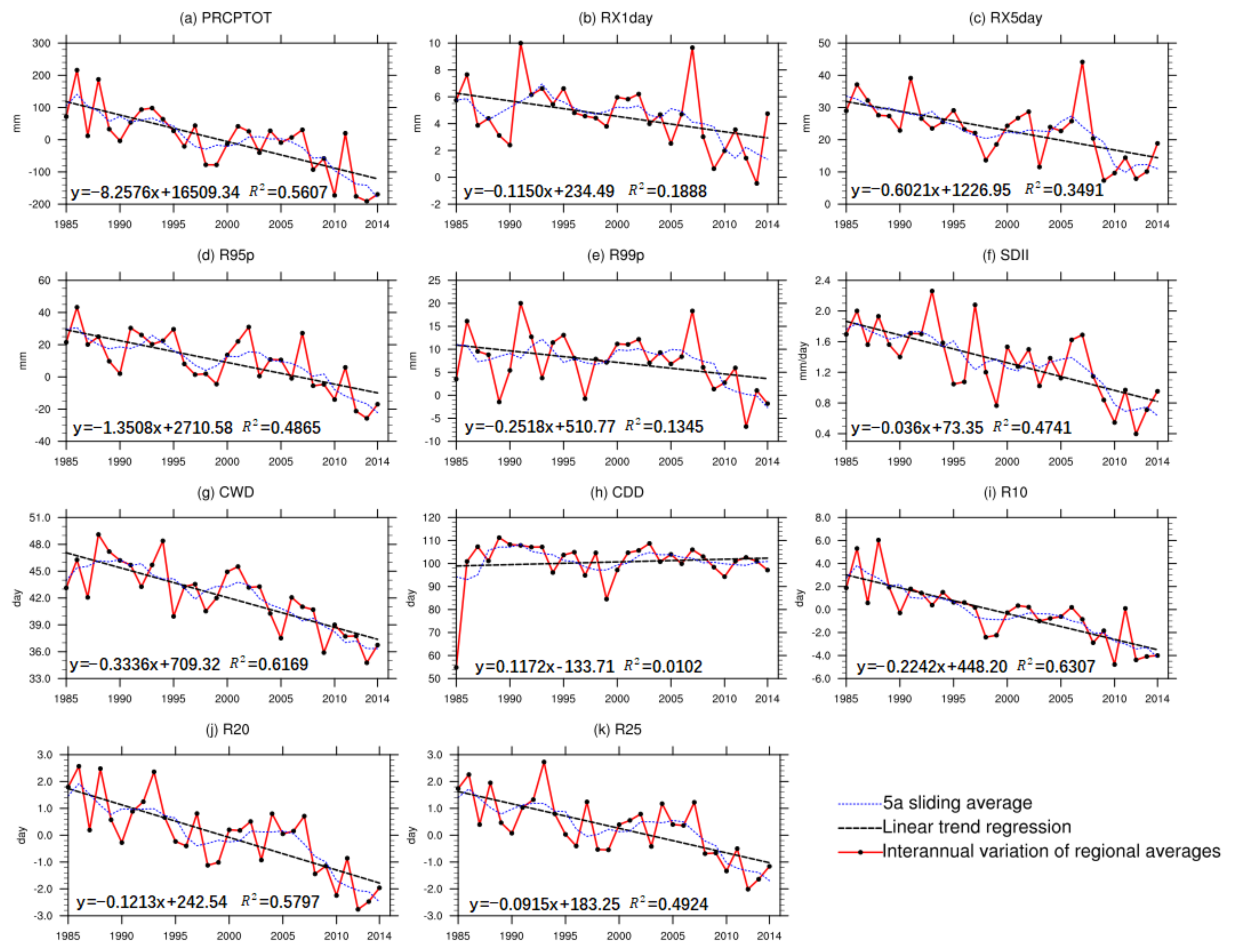
Figure 5 illustrates the trend of differences between extreme-precipitation indicators calculated from the revised rs-MME data and observed precipitation data for the Yangtze River Basin. Positive values indicate overestimation, while negative values indicate underestimation. As depicted in
Figure 5a, the PRCPTOT simulated by the revised rs-MME data fluctuates above and below 0 mm, spanning from −200 mm to 200 mm, with a decreasing trend in differences over time. In
Figure 5b, the post-revision rs-MME data simulate RX1day with a slight overestimation, reaching a maximum overestimation of nearly 10 mm in 1991 and 2007. This trend exhibits a gradual decrease toward 0 mm differences over time. A similar pattern can be observed in
Figure 5c, where RX5day is slightly overestimated, reaching a maximum overestimation of nearly 40 mm in 2007. The trend indicates a decrease in differences over time, gradually approaching 0 mm. In the cases of R95p (
Figure 5d) and R99p (
Figure 5e), the revised rs-MME data initially overestimate and subsequently underestimate, with both indicators exhibiting a decreasing trend in differences over time. The SDII simulated by the revised rs-MME data is generally overestimated and demonstrates a slightly decreasing trend over time (
Figure 5f). Conversely, CWD is significantly overestimated, ranging from about 36 to 48 days, and the difference displays a substantial decreasing trend over time (
Figure 5g). Similarly, CDD is significantly overestimated, fluctuating around 100 days, with no significant trend in the difference (
Figure 5h). The indices R10, R20, and R30 denote absolute precipitation indices. The performance of RX1day, RX5day, R95p, and R99p indicates that the revised rs-MME model mitigates the initial underestimation of extreme precipitation. Differences show a slight decreasing trend with time, eventually leading to underestimation in later periods. The 5-year smoothed line graph confirms that the line closely aligns with the x-axis, affirming the successful simulation of extreme-precipitation indices using the revised rs-MME model data.
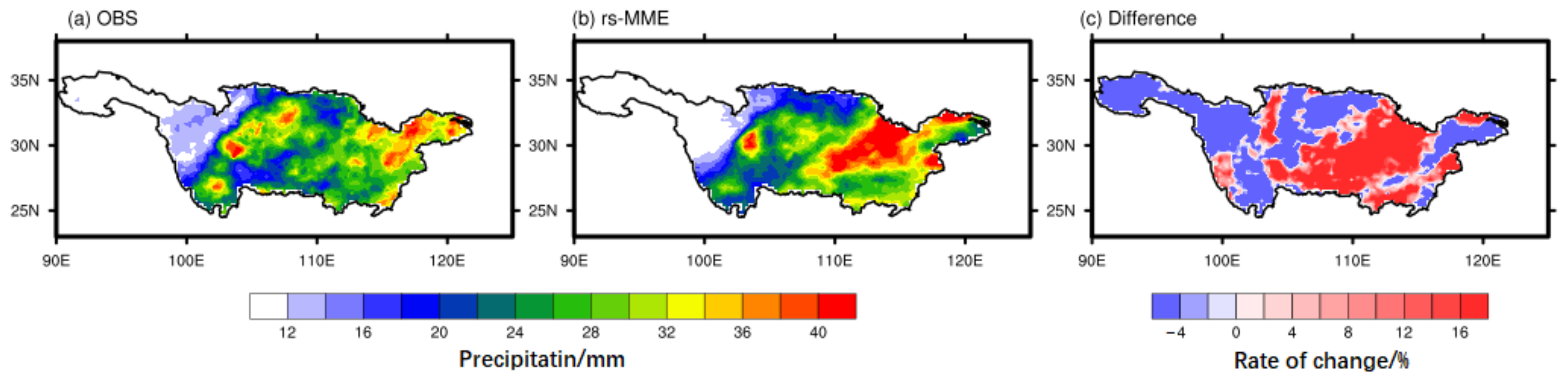
The spatial distribution of the 95% daily precipitation thresholds in the Yangtze River Basin is illustrated in
Figure 6a. It is evident from the figure that the extreme-precipitation thresholds in the headwaters and upstream of the Yangtze River Basin primarily fall within the range of 12–16 mm, while in the middle reaches and downstream regions, they are concentrated between 26 and 36 mm. The most substantial extreme-precipitation thresholds are situated downstream and at the river’s mouth, where the 95% quantile threshold for daily precipitation reaches 38 mm.
Figure 6b portrays the spatial distribution of the 95% quantile thresholds for daily precipitation in the revised rs-MME model data. The outcomes demonstrate a superior simulation of extreme-precipitation thresholds using the revised rs-MME model data. Not only do they more accurately depict the spatial distribution of the 95% quantile precipitation threshold but they also closely align with observations in terms of intensity. By examining the distribution of differences in extreme-precipitation thresholds between observations and rs-MME model data (
Figure 6c), it is evident that the revised rs-MME model slightly overestimates extreme-precipitation thresholds in the middle and lower reaches by approximately 16%. In other areas, the model underestimates the threshold marginally by around 4%.
Figure 3 and
Figure 6 demonstrate the enhanced capacity of the revised BMME model data to accurately simulate both annual precipitation and the spatial distribution of extreme precipitation across the Yangtze River Basin. Additionally,
Figure 5a,f indicates that the revised rs-MME exhibits stronger alignment with observed results for PRCPTOT and SDII indicators, effectively addressing the issue of overestimated mean precipitation in the model data. Furthermore, the oscillating trend around 0 observed in
Figure 5d,e,k for R95p, R99p, R10, R20, and R25 indices suggests that the revised BMME model effectively rectifies the problem of underestimated extreme precipitation within the model data. Based on the comprehensive evaluation provided above, we deduce that the revised rs-MME model adeptly captures the spatial distribution of annual mean precipitation and extreme-precipitation indices. However, its estimations of CWD and CDD are notably overestimated, and its simulation performance regarding the linear trend changes in average annual precipitation is moderate.
4. Future Precipitation and Extreme-Precipitation Changes under Different Scenarios
The rs-MME data for the historical period underwent revisions, and these revised data were employed to evaluate precipitation and extreme-precipitation patterns in the Yangtze River Basin from 1985 to 2014. The outcomes align with the anticipated spatial distribution of precipitation, extreme precipitation, and the corresponding extreme-precipitation index. In the subsequent phase, we intend to further refine the precipitation data across the Yangtze River Basin for the forthcoming three scenarios (SSP1-2.6, SSP2-4.5, and SSP5-8.5). This will be accomplished by employing a transfer function rooted in the cumulative probability-distribution function of the historical period. Consequently, we aim to predict the spatial and temporal distribution of precipitation and extreme precipitation within the region for the forthcoming period.
4.1. Forecast of Future Precipitation Changes
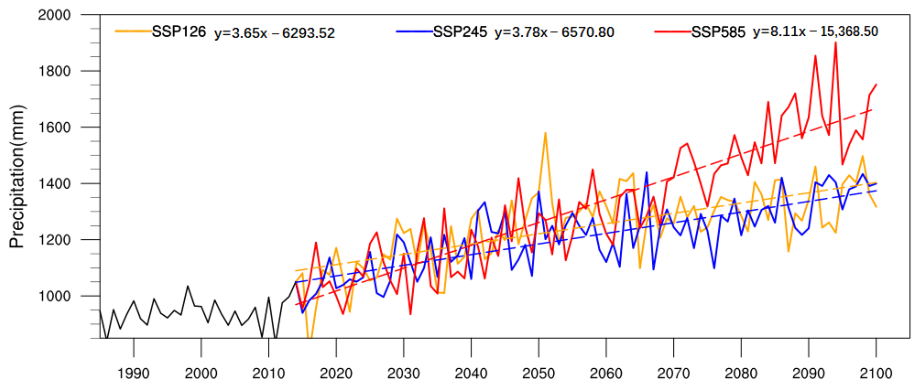
As depicted in
Figure 7, the mean annual precipitation within the Yangtze River Basin is projected to undergo an increase throughout the 21st century across all three scenarios: SSP1-2.6, SSP2-4.5, and SSP5-8.5. These trends exhibit statistical significance at the 0.05 level (
t-test), with noticeable rises in mean annual precipitation fluctuations as well. It is of significance to highlight that the SSP5-8.5 scenario manifests the most prominent upward trend, marked by a precipitation increase of 81.1 mm·
. On the other hand, the SSP1-2.6 and SSP2-4.5 scenarios depict relatively modest upward trends, recording increases of 36.5 mm·
and 37.8 mm·
, respectively.
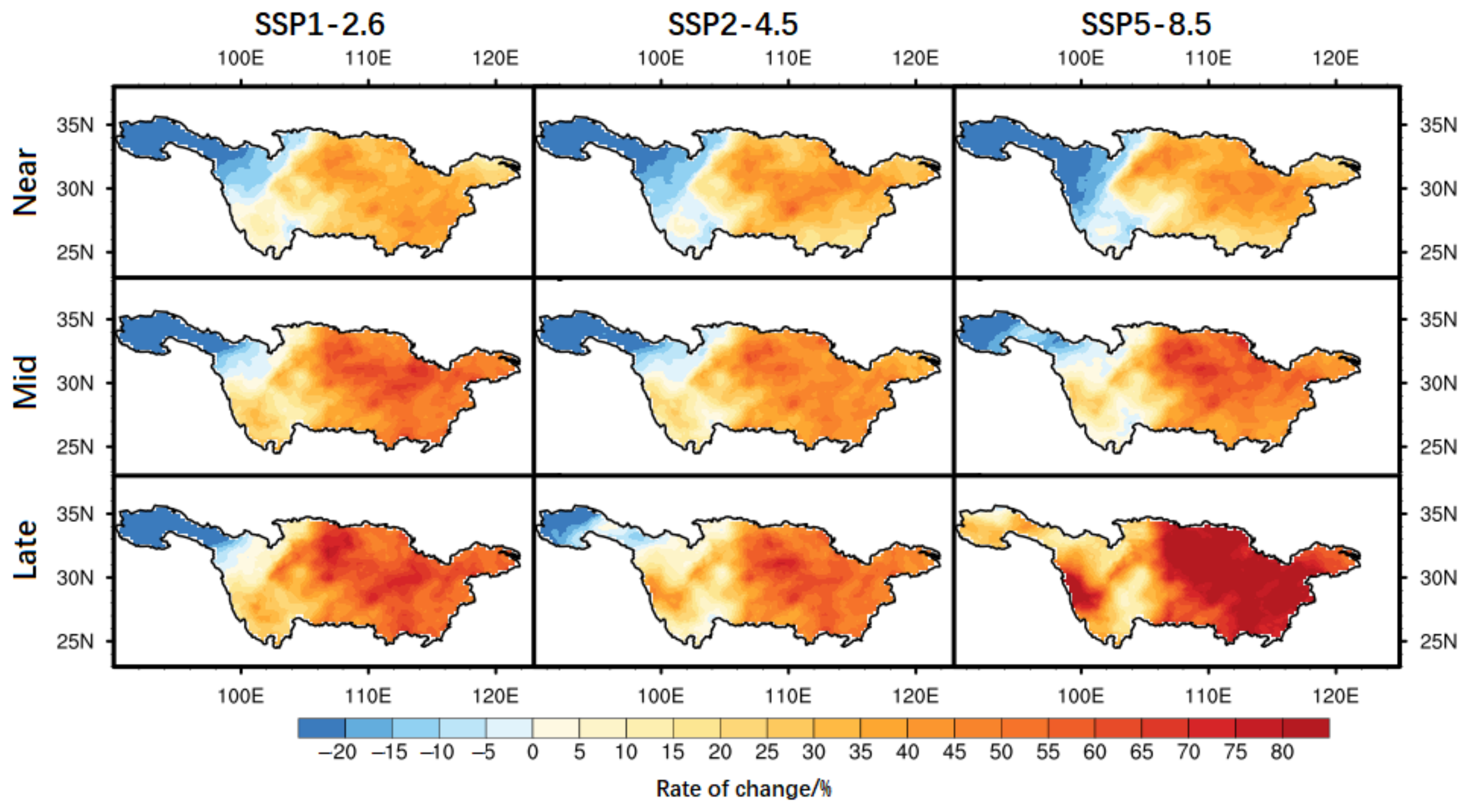
By segmenting the 21st century (21C) into three distinct time intervals—Near 21C (2021–2040), Middle 21C (2041–2070), and Late 21C (2071–2100)—we showcase the spatial variations in mean annual precipitation across the Yangtze River Basin under different scenarios, contrasting them with the historical period (1985–2014), as depicted in
Figure 8. The figure highlights the following observations: In the Near 21C period, the spatial distribution of the mean annual precipitation rate of change across the Yangtze River Basin under the three SSP scenarios exhibits remarkable similarity. Notably, there is a reduction in mean annual precipitation at the headwaters and upstream areas, decreasing by approximately 20% compared to the historical period. Conversely, there is a substantial increase of around 30% in the middle and downstream areas. During the Middle 21C period, the spatial distribution of the mean annual precipitation rate of change closely resembles that of the Near 21C period across different SSP scenarios. In the middle and lower reaches of the Yangtze River Basin, a discernible upward trend in mean annual precipitation emerges, with notable variability concentrated in the middle reaches. Furthermore, the rate of increase surpasses that of the Near 21C period. Among the scenarios, the most significant rise in precipitation, almost 60%, is observed under SSP1-2.6 and SSP5-8.5. Anticipating the Late 21C period, precipitation trends closely mirror those observed during the Mid 21C and Near 21C periods. The only deviation is the notable rise in precipitation levels at the headwaters of the Yangtze River, particularly apparent within the SSP5-8.5 scenario. The central point of the high variability values remains situated within the middle and lower reaches of the basin, reaching a substantial increase of 70%. It is important to highlight that the most significant surge in precipitation is observed during the Late 21C period, followed by the Mid 21C and Near 21C periods. Furthermore, among the scenarios, the SSP5-8.5 scenario exhibits the most considerable increase, succeeded by SSP1-2.6 and SSP2-4.5.
In summary, the mean annual precipitation in the upper reaches of the Yangtze River Basin exhibits a pronounced decreasing trend across all scenarios, with the exception of the SSP5-8.5 scenario, which displays an increasing trend during the Late 21C period. Furthermore, the region characterized by a substantial increase in precipitation change rate is primarily situated within the middle reaches of the Yangtze River Basin. The augmentation of mean annual precipitation demonstrates a progressive increase over time. Importantly, among the three scenarios, the SSP5-8.5 scenario stands out for showcasing the most significant rise in precipitation.
4.2. Forecast of Future Extreme-Precipitation Changes
Figure 9 depicts the normal distributions of the four extreme-precipitation indices for both the historical period and the future scenarios spanning 2021–2100: SSP1-2.6, SSP2-4.5, and SSP5-8.5. In comparison to the historical period, the curves corresponding to the RX1day, RX5day, R95p, and R25 indices for the three future scenarios have shifted towards the right, while their shapes have become flatter. This indicates an augmentation in both the mean and standard deviation of these indices. Specifically, substantial increases are observed in the standard deviation and mean of the maximum daily precipitation for various future scenarios. The shaded region in
Figure 9a highlights the extremities of the future daily maximum precipitation scenarios. Notably, the SSP5-8.5 scenario registers the most substantial surge, with the mean of the maximum daily precipitation nearing 80 mm. This is followed by the SSP2-4.5 scenario and then the SSP1-2.6 scenario.
Figure 9b portrays the normal distribution of the maximum five-day precipitation, revealing that the SSP5-8.5 scenario exhibits a mean maximum five-day precipitation surpassing 220 mm. In comparison, the SSP1-2.6 and SSP2-4.5 scenarios display means of maximum five-day precipitation closer to 210 mm. As demonstrated in
Figure 9c, the normal distributions of the R95p and RX5day indices closely resemble each other. The SSP1-2.6 and SSP2-4.5 scenarios share similar mean values for the R95p index, with both exceeding 300 mm. Nonetheless, they remain smaller than the value of 340 mm in the SSP5-8.5 scenario.
Figure 9d indicates that the number of days with daily precipitation exceeding 25 mm during the year for the next three SSP scenarios hovers around 12, significantly higher than the 5 days recorded during the historical period. The normal distributions of the four aforementioned extreme-precipitation indices underscore that the mean and standard deviation of these indices in the future SSP5-8.5 scenario outpace those in the SSP2-4.5 and SSP1-2.6 scenarios. Notably, the intensification and frequency of extreme precipitation experience the most pronounced rise in the SSP5-8.5 scenario, while minor differences persist between the SSP2-4.5 and SSP1-2.6 scenarios.
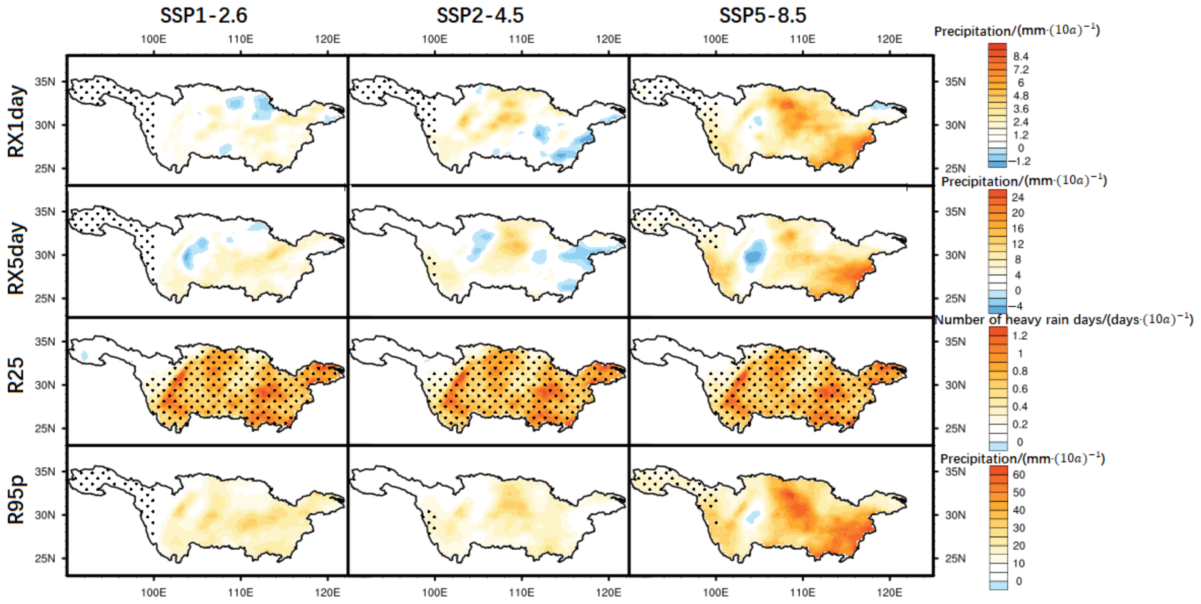
Figure 10 presents the spatial distribution of linear trend changes in four precipitation indices—namely, daily maximum precipitation, five-day maximum precipitation, number of stormy days, and heavy precipitation—in the Yangtze River Basin, considering various SSP scenarios. Within the annual daily maximum precipitation map, the SSP1-2.6 scenario demonstrates a marginal upward trend in the Yangtze River Basin, with a focal point of relatively higher upward trend values situated in the lower reaches of the Yangtze River. Similarly, under the SSP2-4.5 scenario, the Yangtze River Basin manifests a minor upward trend, most notably exhibiting an increase of over 2.4 mm·
in the middle reaches of the river. In contrast, the SSP5-8.5 scenario showcases a conspicuous rise in the maximum daily precipitation throughout the year in the Yangtze River Basin, particularly notable with an increase of 6 mm·
in the middle and lower reaches of the river. The trends in five-day maximum precipitation closely mirror those observed in daily maximum precipitation, indicating a similar pattern of increase. Notably, a small negative center emerges in the upper and middle sections of the Yangtze River under various SSP scenarios. Additionally, a negative center forms at the mouth of the river under the SSP2-4.5 scenario, resulting in a decrease of 4 mm·
. The examination of heavy rainfall days reveals a consistent upward trajectory across the Yangtze River Basin under different SSP scenarios. While the distinctiveness of the upward trend varies minimally among the different scenarios, a significant increase is evident in the midstream and downstream regions of the Yangtze River Basin, reaching up to 1.0 day·
. Furthermore, the heavy precipitation map highlights an augmentation in heavy precipitation events across the Yangtze River Basin in response to different SSP scenarios. This increase is especially pronounced in the midstream and downstream sections of the Yangtze River, particularly evident in the SSP5-8.5 scenarios, where heavy precipitation intensifies significantly. Specifically, the SSP5-8.5 scenario witnesses heavy precipitation, reaching 55 mm.
In summary, the Yangtze River Basin demonstrates a prevailing trend of increased daily and five-day maximum precipitation throughout the year, with the sole exception of a negative center at the river’s mouth within the SSP2-4.5 scenario. Both the number of heavy rainfall days and the quantity of heavy precipitation exhibit an upward trajectory within the basin, with the most prominent rise evident in the middle and lower reaches. Among the extreme-precipitation indices, there is a discernible upward trend in both the intensity and frequency of extreme-precipitation events in the Yangtze River Basin, with the most significant increase observed under the SSP5-8.5 scenario.
5. Conclusions
Utilizing the CMIP6 model data, we assessed the simulation capacity of climate model data from 30 NEX-GDDP-CMIP6 datasets for precipitation, with CN05.1 observations serving as validation data for the Yangtze River Basin. We conducted a weighted-ensemble averaging (rs-MME) of the models based on RS scores, following this by applying the quantile mapping technique to rectify rs-MME data biases. We then evaluated both precipitation and extreme precipitation over the historical period (1985–2014). Subsequently, we conducted evaluations and predictions for precipitation and extreme precipitation within the Yangtze River Basin under the SSP1-2.6, SSP2-4.5, and SSP5-8.5 scenarios for the years 2021–2100. The primary findings are summarized as follows.
The five models exhibiting the most proficient precipitation-simulation performance in the Yangtze River Basin are CanESM5, CNRM-ESM2-1, KIOST-ESM, MPI-ESM1-2-LR, and CMCC-ESM2. The simulation outcomes for precipitation in the historical period within the Yangtze River Basin reveal that differences among the models within the NEX-GDDP-CMIP6 dataset are not substantial; all of them effectively simulate precipitation within the Yangtze River Basin. Each of these models demonstrates satisfactory precipitation simulation within the Yangtze River Basin.
The revised rs-MME model rectifies the overestimation of low values and the underestimation of high values present in the earlier model data. Additionally, it offers an improved simulation of mean annual precipitation, 95% quantile precipitation thresholds, and extreme-precipitation indices throughout most of the historical period. However, the simulation of linear trend changes in mean annual precipitation was moderately accurate, while the CDD and CWD indices were notably overestimated.
We predict that annual mean precipitation in the Yangtze River Basin will increase significantly in the future as the level of forcing radiation rises for different scenarios. The increase in precipitation in the SSP1-2.6 scenario is 36.5 mm·; the increase in precipitation in the SSP2-4.5 scenario is 37.8 mm·; and the increase in precipitation in the SSP5-8.5 scenario is the largest at 81.1 mm·. The spatial distribution of annual average precipitation in the Yangtze River Basin for future time periods reveals that, except for the scenario SSP5-8.5 in the 21st century, which displays an upward trend in annual precipitation at the headwaters and upstream of the Yangtze River Basin, the region demonstrates a downward trend in all other scenarios. Concurrently, the central and downstream regions of the Yangtze River Basin exhibit an upward trend in precipitation, with the most notable rates of change centered within the Yangtze River Basin.
The daily maximum precipitation, five-day maximum precipitation, number of heavy rainfall days, and heavy precipitation amount in the Yangtze River Basin exhibit a slight upward trend in the headwaters under different SSP scenarios in the future. Conversely, there is a noteworthy overall increase in each extreme-precipitation index across the middle and lower reaches of the Yangtze River Basin. Moreover, all extreme-precipitation indices experience a substantial increase under the SSP5-8.5 scenarios.
Author Contributions
Conceptualization, C.Z. and Q.Y.; methodology, C.Z.; software, C.Z. and J.H.; validation, C.Z; formal analysis, C.Z.; investigation, C.Z. and Q.Y.; resources, C.Z.; data curation, C.Z.; writing—original draft preparation, C.Z.; writing—review and editing, C.Z. and Q.Y.; visualization, C.Z. and J.H.; supervision, Q.Y.; project administration, Q.Y.; funding acquisition, Q.Y. All authors have read and agreed to the published version of the manuscript.
Funding
This research was funded by the National Natural Science Foundation of China Project (41671396).
Data Availability Statement
All data included in this study are available upon request by contact with the corresponding author.
Conflicts of Interest
The authors declare no conflict of interest.
References
- Zhou, B.P.; Shi, J.Q.; Li, S.K.; Chen, T.; Ma, L. Spatio-temporal variations of extreme precipitation in the Yangtze River Delta during 1960–2012. J. Yangtze River Sci. Res. Inst. 2016, 33, 5–9. [Google Scholar]
- Wang, J.D.; Su, Z.J.; Zhang, L.N.; Zhang, Y.B. Characteristics of temporal and spatial variation of extreme precipitation index in Gansu Province. Res. Soil Water Conserv. 2022, 29, 270–276+291. [Google Scholar]
- Feng, Y.L.; He, Z.H.; Jiao, S.L.; Liu, W. Scenario prediction of extreme precipitation in Guizhou Province based on CMIP6 climate model. Res. Soil Water Conserv. 2023, 30, 282–290. [Google Scholar]
- Wu, J.; Xia, J.; Zeng, S.D.; Liu, X.; Fan, D. Evaluation of the performance of CMIP6 models and future changes over the Yangtze River basin. Earth Sci. Front. 2023, 30, 515–528. [Google Scholar]
- Sun, C.; Wang, F.; Zhou, Y.H.; Li, L. An assessment on extreme precipitation events in Yangtze River basin as simulated by CWRF regional climate model. Adv. Clim. Change Res. 2022, 18, 44–57. [Google Scholar]
- Ye, X.C.; Wu, Z.W. Contrasting impacts of ENSO on the interannual variations of summer runoff between the upper and mid-lower reaches of the Yangtze River. Atmosphere 2018, 9, 478. [Google Scholar] [CrossRef]
- Shang, Y.C. Population-Economy Coupling in Urban Agglomerations from the perspective of coordinated development of regions. Econ. Rev. J. 2023, 7, 119–128. [Google Scholar]
- Su, B.D.; Xiao, B.; Zhu, D.M.; Jiang, T. Trends in frequency of precipitation extremes in the Yangtze River basin, China: 1960–2003. Hydrol. Sci. J. 2005, 50, 479–492. [Google Scholar]
- Wang, J.; Jiang, Z.H.; Yan, M.L.; Zhang, J.L. Trend of extreme precipitation indices in the mid-lower Yangtze River valley of China during 1960–2005. J. Meteorol. Sci. 2008, 28, 384–388. [Google Scholar]
- Wang, M.; Yin, S.Y. Spatio-temporal variations of the extreme precipitation of middle and lower reaches of the Yangtze River in recent 52 years. Resour. Environ. Yangtze Basin 2015, 24, 1221–1229. [Google Scholar]
- Zou, L.; Xia, J.; Zhang, Y. Spatial-Temporal Characteristics of Extreme Precipitation in the Middle and Lower Reaches of the Yangtze River. Resour. Environ. Yangtze Basin 2021, 30, 1264–1274. [Google Scholar]
- Zhou, T.J.; Zou, L.W.; Chen, X.L. Commentary on the Coupled Model Intercomparison Project Phase 6 (CMIP6). Adv. Clim. Change Res. 2019, 15, 445–456. [Google Scholar]
- Zhu, H.H.; Jiang, S.; Jiang, Z.H. Projection of climate extremes over China in response to 1.5/2.0 °C global warming based on the reliability ensemble averaging. Adv. Earth Sci. 2022, 37, 612–626. [Google Scholar]
- Wang, Y.; Li, H.X.; Wang, H.Q.; Sun, B.; Chen, H.P. Evaluation of CMIP6 model simulations of extreme precipitation in China and comparison with CMIP5. Acta Meteorol. Sin. 2021, 79, 369–386. [Google Scholar]
- Zhu, H.H.; Jiang, Z.H.; Li, J.; Li, W.; Sun, C.; Li, L. Does CMIP6 inspire more confidence in simulating climate extremes over China? Adv. Atmos. Sci. 2020, 37, 119–1132. [Google Scholar] [CrossRef]
- Pan, H.; Jin, Y.J.; Zhu, X.C. Comparison of Projections of Precipitation over Yangtze River Basin of China by Different Climate Models. Water 2022, 14, 1888. [Google Scholar] [CrossRef]
- Li, X.L.; Wang, W.G.; Zhang, S.L. A trend analysis of future precipitation in the Yangtze River Basin based on CMIP6 multi-model. China Rural Water Hydropower 2022, 3, 1–7, 12. [Google Scholar]
- Jin, C.X.; Jiang, C.; Zhang, X.Y. Evaluation and Projection of Temperature in Southwestern China by CMIP6 Models. Chin. J. Agrometeorol. 2022, 43, 597–611. [Google Scholar]
- Wu, J.; Gao, X.J. A gridded daily observation dataset over China region and comparison with the other datasets. Chin. J. Geophys. 2013, 56, 1102–1111. [Google Scholar]
- Thrasher, B.; Wang, W.; Michaelis, A.; Melton, F.; Lee, T.; Nemani, R. NASA Global Daily Downscaled Projections, CMIP6. Sci. Data 2022, 9, 262. [Google Scholar] [CrossRef]
- O’neill, B.C.; Tebalidi, C.; van Vuuren, D.P.; Eyring, V.; Friedlingstein, P.; Hurtt, G.; Knutti, R.; Kriegler, E.; Lamarque, J.F.; Lowe, J.; et al. The scenario model intercomparison project (ScenarioMIP) for CMIP6. Geosci. Model Dev. 2016, 9, 3461–3482. [Google Scholar] [CrossRef]
- Tong, Y.; Gao, X.J.; Han, Z.Y.; Xu, Y. Bias correction of daily precipitation simulated by RegCM4 model over China. Chin. J. Atmos. Sci. 2017, 41, 1156–1166. (In Chinese) [Google Scholar]
- Taylor, K.E. Summarizing multiple aspects of model performance in a single diagram. J. Geophys. Res. Atmos. 2001, 106, 7183–7192. [Google Scholar] [CrossRef]
- Gleckler, P.J.; Taylor, K.E.; Doutriaux, C. Performance metrics for climate models. J. Geophys. Res. 2008, 113, D06104. [Google Scholar] [CrossRef]
- Liu, Z.F.; Wang, R.; Yao, Z.J. Air temperature and precipitation over the Mongolian Plateau and assessment of CMIP 5 climate models. Resour. Sci. 2016, 38, 956–969. [Google Scholar]
- He, C.F.; Lou, C.Y.; Chen, F.L.; Long, A.; Tang, H. CMIP6multi-modelpredictionoffutureclimatechangeintheHotan River Basin. Earth Sci. Front. 2023, 30, 515–528. [Google Scholar]
- Peterson, T.; Folland, C.; Gruza, G.; Hogg, W.; Mokssit, A.; Plummer, N. Report on the Activities of the Working Group on Climate Change Detection and Related Rapporteurs 1998–2001; WMO: Geneve, Switzerland, 2001; 143p. [Google Scholar]
Figure 1.
River network and topography of the Yangtze River Basin. The orange curve represents the main course of the Yangtze River.
Figure 1.
River network and topography of the Yangtze River Basin. The orange curve represents the main course of the Yangtze River.
Figure 2.
Box plots of annual mean precipitation for each model’s data and observation data from 1985 to 2014. • Average annual mean precipitation representing model data and observed data.
Figure 2.
Box plots of annual mean precipitation for each model’s data and observation data from 1985 to 2014. • Average annual mean precipitation representing model data and observed data.
Figure 3.
Spatial variation of observed data, revised rs-MME model, and rate of change in difference between observed data and revised rs-MME model for mean annual precipitation in the Yangtze River Basin (1985–2014).
Figure 3.
Spatial variation of observed data, revised rs-MME model, and rate of change in difference between observed data and revised rs-MME model for mean annual precipitation in the Yangtze River Basin (1985–2014).
Figure 4.
Spatial variation of linear trends in observed annual mean precipitation and revised rs-MME in the Yangtze River Basin (1985–2014). Note: Black dots indicate passing the significance test at the 95% confidence level.
Figure 4.
Spatial variation of linear trends in observed annual mean precipitation and revised rs-MME in the Yangtze River Basin (1985–2014). Note: Black dots indicate passing the significance test at the 95% confidence level.
Figure 5.
Interannual trends in the difference of regional average extreme-precipitation indicators calculated based on CMIP6 model data and observation data.
Figure 5.
Interannual trends in the difference of regional average extreme-precipitation indicators calculated based on CMIP6 model data and observation data.
Figure 6.
Spatial variation of observed data, revised rs-MME model, and difference from observed data to revised rs-MME model for the 95% quantile threshold of annual precipitation in the Yangtze River Basin (1985–2014).
Figure 6.
Spatial variation of observed data, revised rs-MME model, and difference from observed data to revised rs-MME model for the 95% quantile threshold of annual precipitation in the Yangtze River Basin (1985–2014).
Figure 7.
Projected annual mean precipitation variations in the Yangtze River Basin during 2015–2100 across various SSP scenarios.
Figure 7.
Projected annual mean precipitation variations in the Yangtze River Basin during 2015–2100 across various SSP scenarios.
Figure 8.
Spatial distribution of annual mean precipitation in the Yangtze River Basin in the near, mid, and long term relative to the historical-period change rate under different SSP scenarios.
Figure 8.
Spatial distribution of annual mean precipitation in the Yangtze River Basin in the near, mid, and long term relative to the historical-period change rate under different SSP scenarios.
Figure 9.
Normal distribution of extreme-precipitation index for different SSP scenarios in historical period and future. Note: The dashed line indicates the mean and the colored shaded area indicates the higher 5% distribution.
Figure 9.
Normal distribution of extreme-precipitation index for different SSP scenarios in historical period and future. Note: The dashed line indicates the mean and the colored shaded area indicates the higher 5% distribution.
Figure 10.
Spatial distribution of linear trend changes of the four extreme-precipitation indices in the Yangtze River Basin region under different SSP scenarios. Note: The black dots indicate that the significance test at 95% confidence level is passed.
Figure 10.
Spatial distribution of linear trend changes of the four extreme-precipitation indices in the Yangtze River Basin region under different SSP scenarios. Note: The black dots indicate that the significance test at 95% confidence level is passed.
Table 1.
Model names, originating countries, and variants for 30 CMIP6 General Circulation Models (GCMs).
Table 1.
Model names, originating countries, and variants for 30 CMIP6 General Circulation Models (GCMs).
| Model ID | Modeling Country | Variant | Model ID | Modeling Country | Variant |
|---|
| ACCESS-CM2 | Australia | r1i1p1f1 | IITM-ESM | India | r1i1p1f1 |
| ACCESS-ESM1-5 | Australia | r1i1p1f1 | INM-CM4-8 | Russia | r1i1p1f1 |
| BCC-CSM2-MR | China | r1i1p1f1 | INM-CM5-0 | Russia | r1i1p1f1 |
| CanESM5 | Canada | r1i1p1f1 | IPSL-CM6A-LR | France | r1i1p1f1 |
| CESM2 | USA | r4i1p1f1 | KACE-1-0-G | Korea | r1i1p1f1 |
| CMCC-CM2-SR5 | Italy | r1i1p1f1 | KIOST-ESM | Korea | r1i1p1f1 |
| CMCC-ESM2 | Italy | r1i1p1f1 | MIROC-ES2L | Japan | r1i1p1f2 |
| CNRM-CM6-1 | French | r1i1p1f2 | MIROC6 | Japan | r1i1p1f1 |
| CNRM-ESM2-1 | French | r1i1p1f2 | MPI-ESM1-2-HR | Germany | r1i1p1f1 |
| EC-Earth3 | Europe | r1i1p1f1 | MPI-ESM1-2-LR | Germany | r1i1p1f1 |
| EC-Earth3-Veg-LR | Europe | r1i1p1f1 | MRI-ESM2-0 | Japan | r1i1p1f1 |
| FGOALS-g3 | China | r1i1p1f1 | NESM3 | China | r1i1p1f1 |
| GFDL-ESM4 | USA | r1i1p1f1 | NorESM2-LM | Norway | r1i1p1f1 |
| GISS-E2-1-G | USA | r1i1p1f2 | NorESM2-MM | Norway | r1i1p1f1 |
| HadGEM3-GC31-LL | UK | r1i1p1f3 | TaiESM1 | Taiwan, China | r1i1p1f1 |
Table 2.
Extreme-precipitation index [
27].
Table 2.
Extreme-precipitation index [
27].
| Abbreviations | Indicator Name | Definition | Unit |
|---|
| PRCPTOT | Annual precipitation | Daily precipitation ≥ 1 mm daily accumulation of precipitation | mm |
| RX1day | Maximum daily precipitation | Maximum 1-day precipitation during the year | mm |
| RX5day | 5-day maximum precipitation | Maximum continuous 5-day precipitation for the year | mm |
| SDII | Precipitation intensity | Annual precipitation/number of precipitation days | mm/d |
| R10 | Number of days of light rain | Number of days with daily precipitation ≥ 10 mm | d |
| R20 | Number of days of moderate rain | Number of days with daily precipitation ≥ 20 mm | d |
| R25 | Number of days of heavy rain | Number of days with daily precipitation ≥ 25 mm | d |
| R95p | Strong precipitation | Total precipitation with daily precipitation > 95% quantile threshold | mm |
| R99p | Extreme heavy precipitation | Total precipitation with daily precipitation > 99% quantile threshold | mm |
| CDD | Continuous dry period | Maximum number of consecutive days without precipitation | d |
| CWD | Continuous wet period | Maximum number of consecutive precipitation days | d |
Table 3.
Each evaluation index and overall ranking of precipitation-simulation results of each model from 1985 to 2014.
Table 3.
Each evaluation index and overall ranking of precipitation-simulation results of each model from 1985 to 2014.
| Model ID | Correlation Coefficient (R) | Ratio of Standard Deviation ) | Normalized Root-Mean-Square Error (NRMSE) | Skill Score ) | Skill Score ) | Skill Score (MVI) | Mode Score | Overall Ranking |
|---|
| CanESM5 | 0.7101 | 0.9478 | 0.3679 | 0.8393 | 0.6075 | 0.4025 | 1.7917 | 1 |
| CNRM-ESM2-1 | 0.6889 | 0.9681 | 0.3872 | 0.8355 | 0.5969 | 0.3935 | 1.7736 | 2 |
| KIOST-ESM | 0.7046 | 0.9440 | 0.3763 | 0.8372 | 0.6129 | 0.4217 | 1.6034 | 3 |
| MPI-ESM1-2-LR | 0.6959 | 0.9544 | 0.3943 | 0.8289 | 0.5817 | 0.3971 | 1.5672 | 4 |
| CMCC-ESM2 | 0.7170 | 0.9473 | 0.3749 | 0.8410 | 0.6248 | 0.4381 | 1.5547 | 5 |
| ACCESS-ESM1-5 | 0.7066 | 0.9623 | 0.3875 | 0.8319 | 0.5927 | 0.4100 | 1.5399 | 6 |
| IITM-ESM | 0.6932 | 0.9459 | 0.3935 | 0.8321 | 0.5959 | 0.4122 | 1.5382 | 7 |
| EC-Earth3 | 0.6994 | 0.9851 | 0.3703 | 0.8360 | 0.6070 | 0.4234 | 1.5381 | 8 |
| BCC-CSM2-MR | 0.7105 | 0.9332 | 0.3759 | 0.8311 | 0.5977 | 0.4165 | 1.4919 | 9 |
| NorESM2-LM | 0.6966 | 0.9594 | 0.3915 | 0.8364 | 0.6074 | 0.4310 | 1.4712 | 10 |
| CESM2 | 0.7054 | 0.9521 | 0.3786 | 0.8354 | 0.6067 | 0.4292 | 1.4711 | 11 |
| CNRM-CM6-1 | 0.6879 | 0.9546 | 0.4010 | 0.8267 | 0.5800 | 0.4064 | 1.4369 | 12 |
| NorESM2-MM | 0.6864 | 0.9542 | 0.3985 | 0.8315 | 0.5955 | 0.4215 | 1.4352 | 13 |
| MIROC-ES2L | 0.7259 | 0.9147 | 0.3668 | 0.8342 | 0.6164 | 0.4388 | 1.4031 | 14 |
| MPI-ESM1-2-HR | 0.6987 | 0.9620 | 0.3886 | 0.8290 | 0.5864 | 0.4186 | 1.3814 | 15 |
| INM-CM5-0 | 0.6874 | 0.9746 | 0.4053 | 0.8328 | 0.5909 | 0.4285 | 1.3565 | 16 |
| MIROC6 | 0.7073 | 0.9264 | 0.3786 | 0.8251 | 0.5852 | 0.4175 | 1.3351 | 17 |
| GISS-E2-1-G | 0.6929 | 0.9248 | 0.4032 | 0.8273 | 0.5975 | 0.4352 | 1.2558 | 18 |
| IPSL-CM6A-LR | 0.7171 | 0.9179 | 0.3878 | 0.8310 | 0.6103 | 0.4498 | 1.2297 | 19 |
| HadGEM3-GC31-LL | 0.7000 | 0.9168 | 0.3904 | 0.8261 | 0.5925 | 0.4338 | 1.2258 | 20 |
| EC-Earth3-Veg-LR | 0.6966 | 0.9766 | 0.3828 | 0.8267 | 0.5799 | 0.4304 | 1.1981 | 21 |
| CMCC-CM2-SR5 | 0.7052 | 0.9452 | 0.3864 | 0.8278 | 0.5918 | 0.4441 | 1.1423 | 22 |
| NESM3 | 0.7072 | 0.9385 | 0.3882 | 0.8322 | 0.6045 | 0.4569 | 1.1416 | 23 |
| MRI-ESM2-0 | 0.6956 | 0.9539 | 0.3986 | 0.8272 | 0.5871 | 0.4407 | 1.1411 | 24 |
| FGOALS-g3 | 0.7200 | 0.9192 | 0.3826 | 0.8294 | 0.5995 | 0.4540 | 1.1065 | 25 |
| INM-CM4-8 | 0.6870 | 0.9805 | 0.4041 | 0.8325 | 0.5896 | 0.4548 | 1.0831 | 26 |
| ACCESS-CM2 | 0.7218 | 0.9254 | 0.3766 | 0.8236 | 0.5878 | 0.4452 | 1.0547 | 27 |
| KACE-1-0-G | 0.6415 | 0.9714 | 0.4348 | 0.8020 | 0.5355 | 0.4253 | 0.6825 | 28 |
| TaiESM1 | 0.6901 | 0.9278 | 0.4000 | 0.8135 | 0.5657 | 0.4621 | 0.6311 | 29 |
| GFDL-ESM4 | 0.6890 | 0.9047 | 0.4376 | 0.8132 | 0.5761 | 0.4937 | 0.3717 | 30 |
| Disclaimer/Publisher’s Note: The statements, opinions and data contained in all publications are solely those of the individual author(s) and contributor(s) and not of MDPI and/or the editor(s). MDPI and/or the editor(s) disclaim responsibility for any injury to people or property resulting from any ideas, methods, instructions or products referred to in the content. |
© 2023 by the authors. Licensee MDPI, Basel, Switzerland. This article is an open access article distributed under the terms and conditions of the Creative Commons Attribution (CC BY) license (https://creativecommons.org/licenses/by/4.0/).


