Protecting Built Heritage against Flood: Mapping Value Density on Flood Hazard Maps
Abstract
:1. Introduction
2. Assessment of Vulnerable Value: Quick Flood Risk Scan
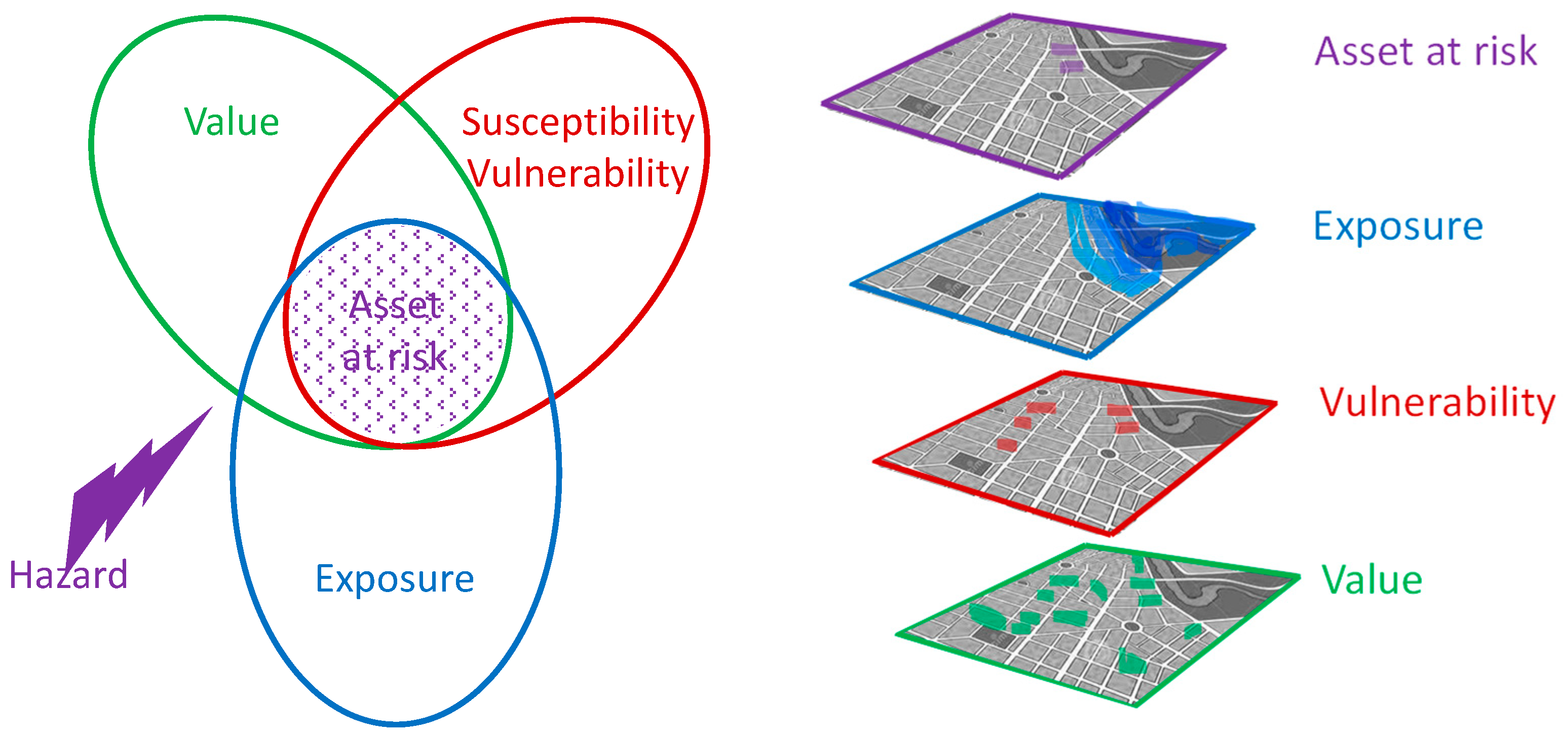
2.1. Principle behind the Method
2.2. Refinement of the Method—Using Expert Opinion
2.3. The Refined Method: Quick Flood Risk Scan
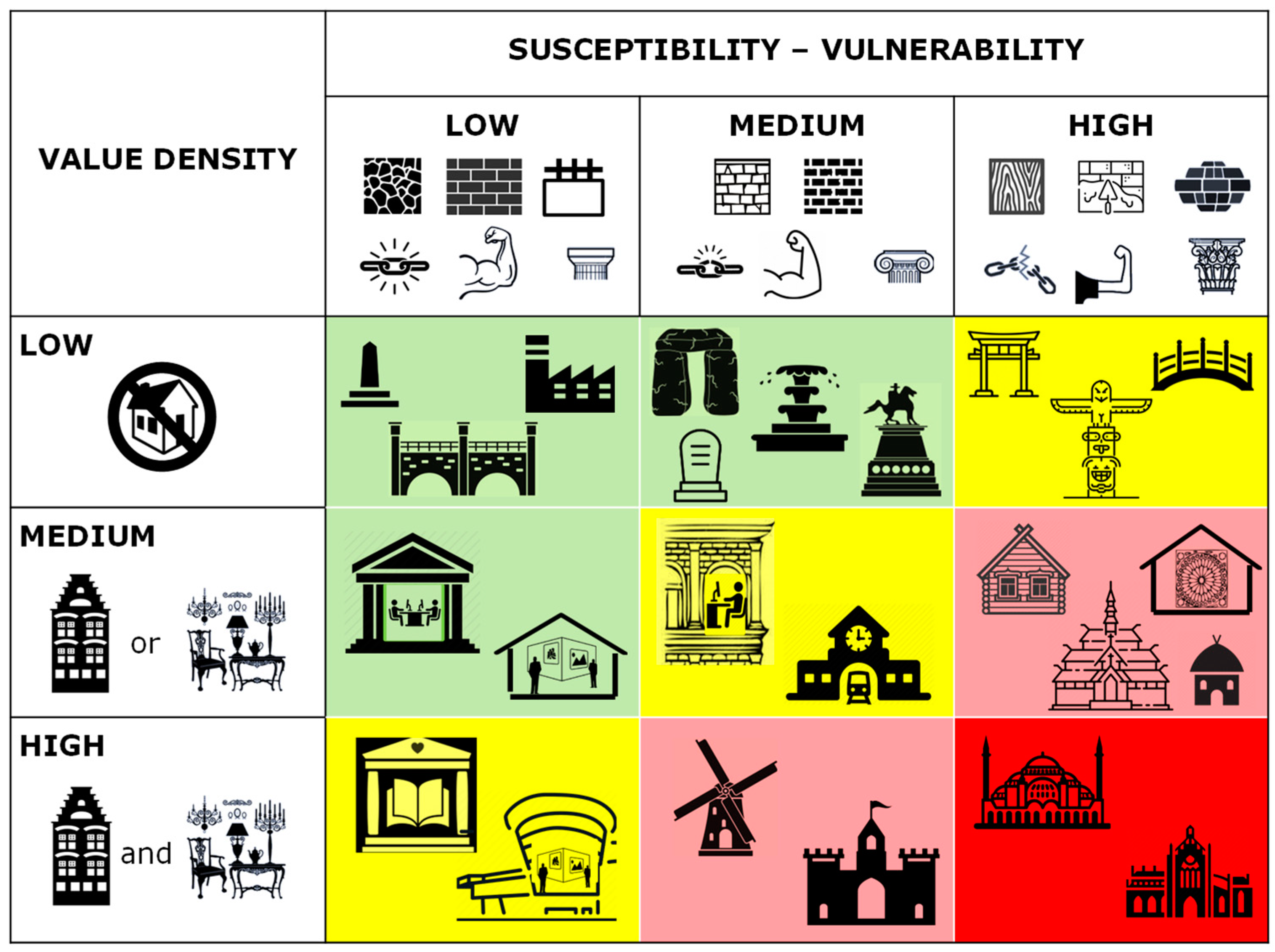
2.3.1. Value Density
- Low:
- A monument that is not a building but a man-made structure above ground that cannot be entered such as street furniture, border markers, tombstones, bridges.
- A building that has lost its original function; it can be an empty building or a building that is listed because of its original function and design but does not function as such any longer, for example, bunkers, fortification towers, brick factory, sheds.
- Medium:
- A significant building with an insignificant interior or content; the building is listed because of its architectural-historic value while the interior is no longer original or has been adapted to a new function, for example, a historic house that is adapted to modern living comfort, a modernised farmhouse, a repurposed windmill.
- A significant interior or content in an insignificant building; the building is listed because of the cultural value of its interior design or the moveable heritage inside, such as a museum in a modern building.
- High:
- A significant building with a significant interior or content; both the building and the interior or moveable heritage inside have cultural value, for example, historic house museums, castles, country estates, and in the Netherlands, certainly the Rijksmuseum.
2.3.2. Vulnerability
- Low:
- Concrete, hard stone, robust material and construction, in reasonable to good condition, probably relatively young (for example >1900);
- Medium:
- Softer, more porous stone, older monuments in a suboptimal condition, low-quality masonry;
- High:
- Plaster, adobe and wood, either used inside or outside, with finer details then the other vulnerability classes.
3. Application of the Quick Flood Risk Scan Method
3.1. Application to Existing Data Sets
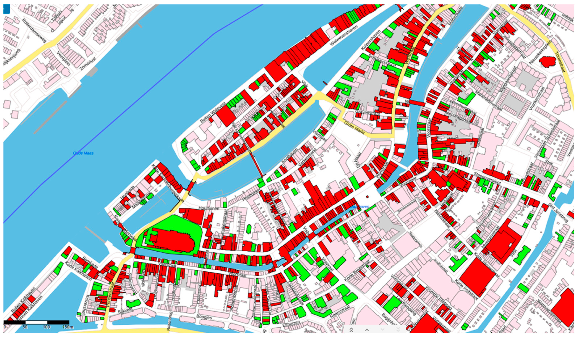
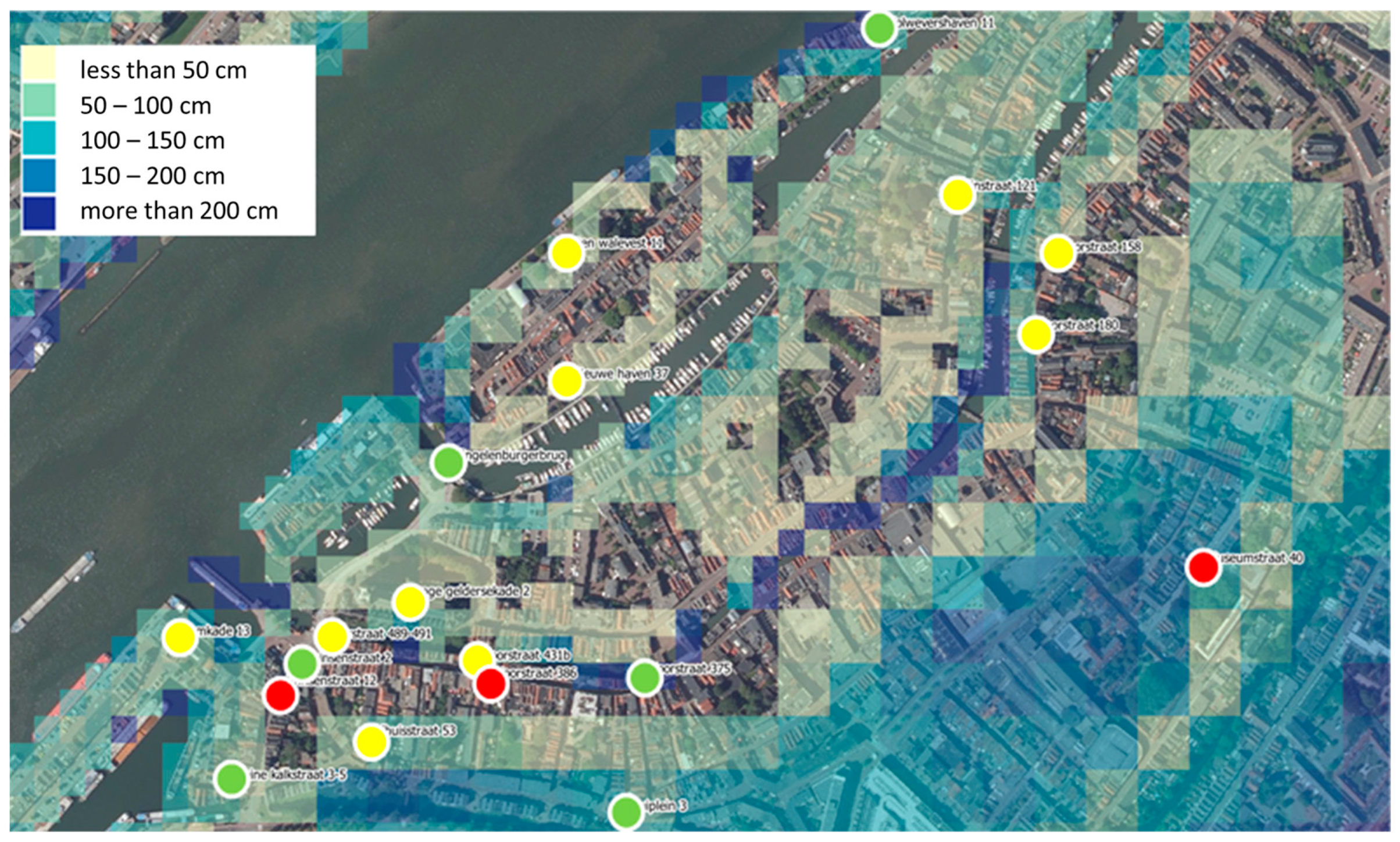
3.2. Field Test for the City of Dordrecht
4. Discussion
4.1. Reflection on the Applicability by Responsible Experts (RQ1)
4.2. Reflection on the Results Obtained (RQ2)
4.3. Value for Informing (Local) Policy Making (RQ3)
5. Conclusions
Author Contributions
Funding
Institutional Review Board Statement
Informed Consent Statement
Data Availability Statement
Acknowledgments
Conflicts of Interest
References
- Arrighi, C. A Global Scale Analysis of River Flood Risk of UNESCO World Heritage Sites. Front. Water 2021, 3, 764459. [Google Scholar] [CrossRef]
- Appiotti, F.; Assumma, V.; Bottero, M.; Campostrini, P.; Datola, G.; Lombardi, P.; Rinaldi, E. Definition of a Risk Assessment Model within a European Interoperable Database Platform (EID) for Cultural Heritage. J. Cult. Herit. 2020, 46, 268–277. [Google Scholar] [CrossRef]
- Durrant, L.J.; Vadher, A.N.; Teller, J. Disaster Risk Management and Cultural Heritage: The Perceptions of European World Heritage Site Managers on Disaster Risk Management. Int. J. Disaster Risk Reduct. 2023, 89, 103625. [Google Scholar] [CrossRef]
- UNESCO. Convention Concerning the Protection of the World Cultural and Natural Heritage. In Proceedings of the 17th Session General Conference, Paris, France, 17 October–21 November 1972; Volume 16. [Google Scholar]
- UNESCO. UNESCO Strategy for Action on Climate Change. In Proceedings of the General Conference 39th Session, (doc 39 C/46), Paris, France, 30 October–14 November 2017. [Google Scholar]
- Center, A.D.R. Sendai Framework for Disaster Risk Reduction 2015–2030; United Nations Office for Disaster Risk Reduction: Geneva, Switzerland, 2015. [Google Scholar]
- European Commission. European Framework for Action on Cultural Heritage; European Commission: Brussels, Belgium, 2019. [Google Scholar]
- European Commission. Directive 2007/60/EC of the European Parliament and of the Council of 23 October 2007 on the Assessment and Management of Flood Risks. Off. J. Eur. Union L. 2007, 288, 27–34. [Google Scholar]
- Garry, G.; Graszk, E.; Hubert, T.; Guyot, T. Plans de Prévention Des Risques Naturels (PPR): Risques d’inondation: Guide Méthodologique; Ministere de l’Aménagement du Territoire et de l’Environnement, Ministere de l’Équipement, Documentation Française: Paris, France, 1999.
- Santato, S.; Bender, S.; Schaller, M. The European Floods Directive and Opportunities Offered by Land Use Planning: CSC Report 12; Climate Service Center: Hamburg, Germany, 2013. [Google Scholar]
- Teruel Cano, D.; Fatorić, S.; Manders, M. The Impacts of Climate Change on Cultural Heritage in the Netherlands: A Preliminary Assessment of Exposure; Delft University of Technology: Delft, The Netherlands, 2020. [Google Scholar]
- Bonazza, A.; Maxwell, I.; Drdácký, M.; Vintzileou, E.; Hanus, C. Safeguarding Cultural Heritage from Natural and Man-Made Disasters: A Comparative Analysis of Risk Management in the EU; Publications Office of the European Union: Luxembourg, 2018. [Google Scholar]
- Romão, X.; Bertolin, C. Risk Protection for Cultural Heritage and Historic Centres: Current Knowledge and Further Research Needs. Int. J. Disaster Risk Reduct. 2022, 67, 102652. [Google Scholar] [CrossRef]
- Crowley, K.; Jackson, R.; O’connell, S.; Karunarthna, D.; Anantasari, E.; Retnowati, A.; Niemand, D. Cultural Heritage and Risk Assessments: Gaps, Challenges, and Future Research Directions for the Inclusion of Heritage within Climate Change Adaptation and Disaster Management. Clim. Resil. Sustain. 2022, 1, e45. [Google Scholar] [CrossRef]
- Arrighi, C.; Brugioni, M.; Castelli, F.; Franceschini, S.; Mazzanti, B. Flood Risk Assessment in Art Cities: The Exemplary Case of Florence (Italy). J. Flood Risk Manag. 2018, 11, S616–S631. [Google Scholar] [CrossRef]
- Figueiredo, R.; Romao, X.; Paupério, E. Flood Risk Assessment of Cultural Heritage at Large Spatial Scales: Framework and Application to Mainland Portugal. J. Cult. Herit. 2020, 43, 163–174. [Google Scholar] [CrossRef]
- Vojinovic, Z.; Hammond, M.; Golub, D.; Hirunsalee, S.; Weesakul, S.; Meesuk, V.; Medina, N.; Sanchez, A.; Kumara, S.; Abbott, M. Holistic Approach to Flood Risk Assessment in Areas with Cultural Heritage: A Practical Application in Ayutthaya, Thailand. Nat. Hazards 2016, 81, 589–616. [Google Scholar] [CrossRef]
- Marzeion, B.; Levermann, A. Loss of Cultural World Heritage and Currently Inhabited Places to Sea-Level Rise. Environ. Res. Lett. 2014, 9, 034001. [Google Scholar] [CrossRef]
- Daungthima, W.; Hokao, K. Analysing the Possible Physical Impact of Flood Disasters on Cultural Heritage in Ayutthaya, Thailand. Int. J. Sustain. Future Hum. Secur. J-SustaiNVol 2013, 1, 35–39. [Google Scholar] [CrossRef]
- Reimann, L.; Vafeidis, A.T.; Brown, S.; Hinkel, J.; Tol, R.S.J. Mediterranean UNESCO World Heritage at Risk from Coastal Flooding and Erosion Due to Sea-Level Rise. Nat. Commun. 2018, 9, 4161. [Google Scholar] [CrossRef]
- Stephenson, V.; D’ayala, D. A New Approach to Flood Vulnerability Assessment for Historic Buildings in England. Nat. Hazards Earth Syst. Sci. 2014, 14, 1035–1048. [Google Scholar] [CrossRef]
- Godfrey, A.; Ciurean, R.L.; Van Westen, C.J.; Kingma, N.C.; Glade, T. Assessing Vulnerability of Buildings to Hydro-Meteorological Hazards Using an Expert Based Approach–An Application in Nehoiu Valley, Romania. Int. J. Disaster Risk Reduct. 2015, 13, 229–241. [Google Scholar] [CrossRef]
- Gandini, A.; Egusquiza, A.; Garmendia, L.; San-José, J.-T. Vulnerability Assessment of Cultural Heritage Sites towards Flooding Events. In Proceedings of the IOP Conference Series: Materials Science and Engineering; IOP Publishing: Bristol, UK, 2018; Volume 364, p. 012028. [Google Scholar]
- Trizio, F.; Torrijo, F.J.; Mileto, C.; Vegas, F. Flood Risk in a Heritage City: Alzira as a Case Study. Water 2021, 13, 1138. [Google Scholar] [CrossRef]
- Brokerhof, A.W.; Bülow, A.E. The QuiskScan—A Quick Risk Scan to Identify Value and Hazards in a Collection. J. Inst. Conserv. 2016, 39, 18–28. [Google Scholar] [CrossRef]
- Luger, T.; Brokerhof, A.; Hartog, S.; Huisman, G. Assessing Museum Collections: Collection Valuation in Six Steps; Cultural Heritage Agency of the Netherlands: Amersfoort, The Netherlands, 2014; Available online: http://cultureelerfgoed.nl/publicaties/assessing-museum-collections (accessed on 28 March 2017).
- FEMA Understanding Your Risks–Identifying Hazards and Estimating Loss Potential. Available online: https://mitigation.eeri.org/wp-content/uploads/FEMA_386_2.pdf (accessed on 8 July 2023).
- Zakharovskyi, V.; Németh, K. Quantitative-Qualitative Method for Quick Assessment of Geodiversity. Land 2021, 10, 946. [Google Scholar] [CrossRef]
- Zakharovskyi, V.; Németh, K. Qualitative-Quantitative Assessment of Geodiversity of Western Samoa (SW Pacific) to Identify Places of Interest for Further Geoconservation, Geoeducation, and Geotourism Development. Geographies 2021, 1, 362–380. [Google Scholar] [CrossRef]
- Brokerhof, A.W.; Ankersmit, H.A.; Ligterink, F.J. Risk Management for Collections; Cultural Heritage Agency of the Netherlands: Amersfoort, The Netherlands, 2017; ISBN 9057992833. [Google Scholar]
- Center for Disaster Management and Risk Reduction Technology (CEDIM). Risk Map Germany>Earthquake Risk. Website, Karlsruhe Institute of Technology. Available online: https://www.cedim.kit.edu/english/1017.php (accessed on 10 August 2023).
- Technalia Shelter Website. Available online: https://shelter-project.com/ (accessed on 8 July 2023).
- Bloemen, P.J.T.M.; Hammer, F.; van der Vlist, M.J.; Grinwis, P.; van Alphen, J. DMDU into Practice: Adaptive Delta Management in the Netherlands. In Decision Making under Deep Uncertainty: From Theory to Practice; Springer: Cham, Switzerland, 2019; pp. 321–351. [Google Scholar] [CrossRef]
- Slager, K. Handboek Overstromingsrisico’s Op de Kaart: Over de Methode van Kaartproductie, Project Number 11203685-006; Deltares: Delft, The Netherlands, 2019. [Google Scholar]
- City of Dordrecht Monumentenkaart. Available online: https://www.monumentenzorgdordrecht.nl/monumenten/monumentenkaart (accessed on 8 July 2023).
- Tyagunov, S.; Grünthal, G.; Wahlström, R.; Stempniewski, L.; Zschau, J. Seismic Risk Mapping for Germany. Nat. Hazards Earth Syst. Sci. 2006, 6, 573–586. [Google Scholar] [CrossRef]
- Wu, J.; He, X.; Ye, M.; Wang, C. Energy and Asset Value Elasticity of Earthquake-Induced Direct Economic Losses. Int. J. Disaster Risk Reduct. 2019, 33, 229–234. [Google Scholar] [CrossRef]
- Zuzak, C.; Mowrer, M.; Goodenough, E.; Burns, J.; Ranalli, N.; Rozelle, J. The National Risk Index: Establishing a Nationwide Baseline for Natural Hazard Risk in the US. Nat. Hazards 2022, 114, 2331–2355. [Google Scholar] [CrossRef]
Disclaimer/Publisher’s Note: The statements. opinions and data contained in all publications are solely those of the individual author(s) and contributor(s) and not of MDPI and/or the editor(s). MDPI and/or the editor(s) disclaim responsibility for any injury to people or property resulting from any ideas. methods. instructions or products referred to in the content. |


| ID | Designation | Type | Figueiredo et al. | Quick Flood Risk Scan | |||||
|---|---|---|---|---|---|---|---|---|---|
| Value Index | Vul Class | HFI (RP = 1000 y) | Flood Impact | Val Den | Vul | Vul Val | |||
| 1 | Mosteiro de Ermelo | Monastery | 15 | A | 5.00 | 75.00 | H | M | HM |
| 2 | Termas Medicinais Romanas de Chaves | Bath house | 15 | B | 4.00 | 60.00 | M | M | MM |
| 3 | Capela do Anjo da Guarda | Chapel | 15 | B | 4.00 | 60.00 | M | M | MM |
| 4 | Convento de São Gonçalo de Amarante | Convent | 15 | A | 5.00 | 75.00 | H | H | HH |
| 5 | Igreja de Santa Maria sobre o Tâmega | Church | 10 | A | 5.00 | 50.00 | H | H | HH |
| 6 | Igreja Paroquial de S. Nicolau | Church | 10 | A | 5.00 | 50.00 | H | H | HH |
| 7 | Capela de São Lázaro | Chapel | 10 | A | 5.00 | 50.00 | M | H | MH |
| 8 | Igreja da Misericórdia de Constância | Church | 10 | A | 5.00 | 50.00 | H | H | HH |
| 11 | Pelourinho de São Nicolau de Canaveses | Pillory | 15 | D | 3.00 | 45.00 | L | M | LM |
| 12 | Castelo de Almourol | Castle | 15 | C | 3.00 | 45.00 | M | M | MM |
| 14 | Casa Júlio Resende | House | 10 | B | 4.00 | 40.00 | H | M | HM |
| 15 | Casa dos Arcos/Casa de Camões | House (ruin) | 10 | B | 4.00 | 40.00 | L | H | LH |
| 16 | Edifício da Capitania do Porto de Aveiro | Building | 10 | B | 4.00 | 40.00 | H | M | HM |
| 17 | Ermida de Nossa Senhora do Ameal | Chapel | 15 | A | 4.69 | 70.35 | M-H | H | MH-HH |
| 18 | Igreja da Misericórdia de Ponte de Lima | Church | 10 | A | 5.00 | 50.00 | H | H | HH |
| 19 | Torres de São Paulo e da Cadeia | Tower | 10 | B | 4.00 | 40.00 | M | L | M |
| 20 | Piscina de D. Afonso Henriques | Bath house (ruin) | 15 | E | 3.00 | 45.00 | L | H | LH |
| 21 | Igreja Paroquial da Póvoa de S. Adrião | Church | 15 | A | 1.43 | 21.45 | H | H | HH |
| 22 | Convento e Igreja de Santa Iria | Convent | 15 | A | 3.69 | 55.35 | H | H | HH |
| 23 | Torre de Lapela | Tower | 15 | B | 4.00 | 60.00 | M | L-M | ML-MM |
| 24 | Capela de N. S. da Penha de França | Chapel | 10 | A | 5.00 | 50.00 | H | H | HH |
| 25 | Central de Captação de Água da Foz do Sousa | Pumping station | 10 | E | 3.00 | 30.00 | L-M | L-M | LL-MM |
| 27 | Cruzeiro do Senhor da Boa Passagem | Calvary | 10 | D | 3.00 | 30.00 | L | M | M |
| 29 | Cais em Abrantes | Pier | 10 | E | 3.00 | 30.00 | L | L | LL |
| 35 | Pelourinho de Constância | Pillory | 10 | D | 3.00 | 30.00 | L | M | LM |
| 47 | Padrão de D. Sebastião | Stone pillar | 10 | D | 3.00 | 30.00 | L | M | LM |
| ID | Designation | Type of Building | Vulnerability Index | Quick Flood Risk Scan | ||
|---|---|---|---|---|---|---|
| Value Density | Vulnerability | Vulnerable Value | ||||
| 1 | Barton Street. Tewkesbury | Timber frame residential. NL 1 | 215/500 | 0 | H | 0H |
| 2 | Mill Bank. Tewkesbury | Timber frame residential. GII 2 | 290/500 | M | H | MH |
| 3 | Water Lane. Winchester | Brick masonry residential. NL | 177.5/500 | 0 | M | 0H |
| 4 | Kingsgate Street. Winchester | Brick masonry residential. GII | 327.5/500 | M | M | MM |
| 5 | Riverfront. York | Brick masonry commercial. NL | 185/500 | 0 | M | 0M |
| 6 | Fishergate. York | Brick masonry commercial. GII | 305/500 | M | M | MM |
Disclaimer/Publisher’s Note: The statements, opinions and data contained in all publications are solely those of the individual author(s) and contributor(s) and not of MDPI and/or the editor(s). MDPI and/or the editor(s) disclaim responsibility for any injury to people or property resulting from any ideas, methods, instructions or products referred to in the content. |
© 2023 by the authors. Licensee MDPI, Basel, Switzerland. This article is an open access article distributed under the terms and conditions of the Creative Commons Attribution (CC BY) license (https://creativecommons.org/licenses/by/4.0/).
Share and Cite
Brokerhof, A.W.; van Leijen, R.; Gersonius, B. Protecting Built Heritage against Flood: Mapping Value Density on Flood Hazard Maps. Water 2023, 15, 2950. https://doi.org/10.3390/w15162950
Brokerhof AW, van Leijen R, Gersonius B. Protecting Built Heritage against Flood: Mapping Value Density on Flood Hazard Maps. Water. 2023; 15(16):2950. https://doi.org/10.3390/w15162950
Chicago/Turabian StyleBrokerhof, Agnes W., Renate van Leijen, and Berry Gersonius. 2023. "Protecting Built Heritage against Flood: Mapping Value Density on Flood Hazard Maps" Water 15, no. 16: 2950. https://doi.org/10.3390/w15162950
APA StyleBrokerhof, A. W., van Leijen, R., & Gersonius, B. (2023). Protecting Built Heritage against Flood: Mapping Value Density on Flood Hazard Maps. Water, 15(16), 2950. https://doi.org/10.3390/w15162950


